Civic Center District
|
|
|
- Jasper Fleming
- 5 years ago
- Views:
Transcription
1
2 Civic Center District The Civic Center district is the civic and social heart of Warrenville, containing such public buildings as the City Hall, Warrenville Public Library, Police Station, Park District Recreation Center, and Community Building. This district also functions as an important community gateway due to its exposure along Butterfield Road, a major arterial slated for future expansion, and along the Prairie Path, a prominent regional bike trail. The Subarea Plan recommendations for the Civic Center district are intended to preserve the small town neighborhood character of the area, and increase its level of activity and vitality by introducing residential and commercial uses in key locations. Major components of the Preferred Concept for the Civic Center include: Enhancements within and along the Butterfield Road right-of-way that improve bicycle, pedestrian, and vehicular access to the District and provide it with a distinct identity Redevelopment of old industrial sites with residential uses, particularly the City-owned Musselman Lumber site adjacent to the Library Retail and mixed-use development focusing on the Butterfield/Batavia intersection to create a strong area gateway and capitalize on its traffic and visibility Improved physical connections between the core of the Civic Center and DuPage River, allowing the river to function as a major amenity for the district Reconfiguration of key local streets such as Manning Avenue, Rockwell Street, and Stafford Place to improve access, circulation, and safety Maintaining and enhancing the publicly owned open space available for community events S. B. Friedman & Company 16 The Lakota Group.
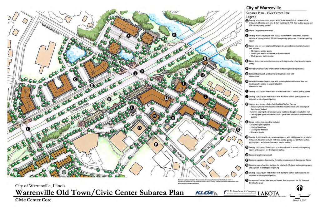
3 CIVIC CENTER SITE-SPECIFIC RECOMMENDATIONS Civic Center Core In addition to several civic/governmental facilities, the core of the Civic Area also includes the Prairie Path, a gazebo, the Roundhouse, and the Veterans and War Memorials. The Subarea Plan seeks to enhance these facilities and spaces while providing additional retail and housing opportunities to add vitality to the Civic Center. Stafford Place/Civic Green Area. To improve and green the front door of the Civic Center along Butterfield Road and increase the districts visibility, the Subarea Plan recommends a major reorganization of open space and parking lots, including the following changes: o Realign the Prairie Path closer to Butterfield Road to provide safer crossings for pedestrians and bicyclists at the Batavia Road and Rockwell Street intersections and increase useable open space near the civic buildings o Thin out overgrown landscaping along the Prairie Path to improve visibility between the Civic Center, path, and roadway o In the larger open space, create a community garden to add color and beauty to the area and help reinforce this location as an attractive front door to the district o In the new open space, establish a Great Lawn that can be a passive recreational space as well as a staging area for community events o Reduce the size and prominence of the parking lot in front of City Hall by reconfiguring off-street and on-street parking in the core. o Create a two-lane travel loop through the reconfigured parking areas o Create a wide landscaped island within the travel loop to accommodate the Roundhouse and memorial o Enhance the north façade of the existing commercial building at the northwest corner of Warren and Manning Avenues Oakbrook Bank Site. To further enhance the visibility of the Civic Center district, a three-story mixed-use building is shown as a prominent focal point at the highly visible intersection of Butterfield Road and Batavia Road. The mixed-use building also helps frame the new Main Street along Batavia Road, which includes new retail/restaurant buildings between the Prairie Path and Tracy Place. These buildings would replace the stormwater detention pond in front of the Police Station, some dated or inefficient commercial buildings, and two homes on the north side of Batavia. Some public workshop participants voiced a desire for existing angle parking to be converted to S. B. Friedman & Company 20 The Lakota Group.
4 Parallel to reduce conflicts with traffic on Batavia Road. This change could be considered in conjunction with new development on the site if it results in a substantial improvement of the pedestrian along Batavia. Manning Avenue. To increase access to the new Main Street shops along Batavia and to the river, Manning Avenue is shown as a full intersection at Batavia and extends north into a parking lot behind the shops. This lot could be shared by shoppers and those seeking recreational access to the river and the Prairie Path. A boat house/canoe launch is shown along the river at the intersection of the Prairie Path and a new trail that would run along the River to the Old Town District. New commercial development is continued south along Manning with a small retail building at Warren and a single-family home potentially converted into a restaurant or tea house. Parking for these new uses includes a combination of small shared on-site lots and on-street spaces. Stresney Piano Site. At the northeast corner of Butterfield and Batavia, a mixed-use development is shown with a restaurant overlooking the river and a new multi-use trail on the north side of Butterfield. This restaurant could include an outdoor dining patio, taking advantage of views of water and woods. The Plan also shows a second restaurant along Batavia Road and a condominium building at the river. North Side of Butterfield East of Rockwell. To the west between Butterfield Road and the Post Office, the Plan shows the vacation of a portion of Calumet Avenue between Rockwell and Butterfield, which removes an angled intersection near the busy Batavia and Butterfield Road intersection, and opens up a highly visible development opportunity site. An extension of Rockwell to Butterfield provides access from the west side of this site. Between Batavia and Rockwell, the Plan masses retail and mixed-use buildings along Butterfield Road to frame the roadway with new activity and visually connect it to the Civic Center Core. Rather than placing buildings away from the road, behind large parking fields, the Plan creates a one-way edge road or boulevard street accessible from Butterfield Road, Batavia Road, and Rockwell Street. The Plan shows two retail-only buildings and a mixed-use building along Butterfield west of Rockwell. The buildings are envisioned with entrances oriented to the proposed edge road, but include parking pockets to allow convenient auto access. Stormwater detention is indicated at the rear of the site, where a low area already exists. The site access point on Batavia closest to Butterfield would likely be limited to right-in turning movements only, while the access point farther to the west near the Post Office would allow all turning movements. The figure on the following page summarizes the key transportation-related recommendations for the Civic Center district, including key site access issues. S. B. Friedman & Company 21 The Lakota Group.

5 Summary of Key Transportation Improvements in Civic Center Civic Center Alternate An alternate concept shows restaurants, retail buildings and/or mixed-use buildings with ground floor commercial and upper floor office or residential forming a more continuous street wall along the edge road with parking and stormwater detention at the rear of the site. This orientation relocates the larger parking pods to the north side of the buildings. It is important that these retail buildings maintain working entrances oriented to the edge road in order to achieve the desired character. This may create a need for pedestrian pass-throughs between retail spaces to access rear parking areas or encourage double-sided retail buildings. Civic Center Residential Area To the west of City Hall and the Library, the Subarea Plan shows a mix of new housing, including townhomes, single-family homes, and a 90-unit senior rental housing building. These new residential opportunities are shown on the currently vacant Musselman lumber site, on currently industrial blocks south of Butterfield and west of Rockwell, and vacant or underutilized parcels north of Butterfield and west of Rockwell. Rockwell Realignment. To facilitate redevelopment and traffic safety in this area, Rockwell Street is shown reconfigured to take out its angled intersections with both S. B. Friedman & Company 22 The Lakota Group.
6 Stafford and Butterfield. The new orientation of Rockwell creates 90-degree intersections with both streets and the Prairie Path and improves sight lines for motorists and bicyclists. It also provides a clearer travel path via Stafford to the existing civic facilities and new retail activity proposed along Stafford and Batavia. Musselman Lumber Site. The redevelopment of the Musselman site is envisioned as an alley-loaded townhome project that creates a front-door presence for the Civic Center on Stafford, and is accessed from Mount Street and Manning Avenue to the south. The townhomes would act as a transition from Butterfield Road to the single-family homes along Ray Street to the south. Three single-family homes with detached garages accessed off the proposed private alley are recommended along the Ray Street frontage of the site. Industrial Area (NWC of Rockwell and Main). On the west side of Rockwell, the existing industrial properties are shown redeveloped with a new senior housing building, and townhomes. The taller senior building is set to the northwest side of the property, farther from single-family uses. The senior housing concept is in response to a projected demographic trend noted in the Residential Market Analysis (see Volume 2 of this report) of growth in households headed by people over 65 years in age with annual incomes of $50,000 or less. To address this trend, the City may wish to explore configuring this building as an income-restricted project benefiting from Section 42 tax credits to enhance affordability. North Side of Butterfield West of Rockwell. Three mixed-use buildings and two condominium buildings are shown oriented around a detention feature. The retail components of the development are oriented towards the boulevard-style edge road along Butterfield that continues through this development and connects to an existing office development to the west. Large landscape buffers would create screening and separation from the single-family residential to the north. Additional Plan Recommendations Parking. The recommended development projects shown in the Subarea Plan offer some potential for sharing of parking between sites and uses. In mixed-use districts, this concept can allow for reductions in the overall amount of needed parking spaces. Shared parking opportunities exist where land uses grouped within a short walking distance generate different parking demand peaks. For example, office uses tend to have maximum parking demand during normal business hours, while restaurants peak at lunch and/or in the evening. The City should explore shared parking opportunities wherever possible, potentially using this concept as a basis for reduced parking ratios for new development in some locations. The best opportunities appear to exist: o In the Civic Center core area, where public uses such as City Hall the Library, and public river access are clustered with proposed retail and restaurant development S. B. Friedman & Company 23 The Lakota Group.
7 o To a lesser extent in the Old Town area around the Warrenville/River/Batavia Road intersection, where restaurant, condo, and recreational/open space uses are located adjacent to proposed shared surface parking lots Building Height. Participants in the community workshops held during the planning process indicated general sensitivity to building height, but recognized the need for sufficient development density to allow economically feasible projects. Based on participant feedback, an incremental additional amount of height and/or density (e.g. one additional story) beyond that shown in the Subarea Plan may be tolerable in some portions of the Study Area if it can be demonstrated to substantially improve the feasibility of a proposed development project. The areas where this concept applies are specifically called out in the Subarea Plan exhibits in this section, and discussed further in the Policies and Implementation Action Steps chapter of this report. Butterfield Road Expansion. The plan for the Civic Center Area incorporates the premise that IDOT will work with the City to adjust the proposed design for the future expansion of Butterfield Road to be more sensitive to the existing small town character of Warrenville and reflective of the traditional/walkable character this plan promotes. The public and numerous stakeholders repeatedly voiced this expectation throughout the public input process for this plan. In an effort to satisfy the community s expectations and at the same time recognize IDOT s responsibility to provide safe and efficient regional and sub-regional traffic movement, this plan recommends a boulevard treatment in the future Butterfield Road expansion project. As shown in the illustrative development concepts included in this Plan, a key component of the boulevard design is separating regional and sub-regional traffic from local traffic by providing a one-way local access road generally within the existing 200 foot wide Butterfield Road right-of-way (ROW). The one-way local access road would be located in the north edge of the Butterfield Road ROW, would provide safe and efficient vehicular access to a significant amount of existing and proposed new development, and would include either parallel and/or angled parking. The proposed boulevard treatment also includes significant streetscape and at-grade pedestrian improvements that collectively work together to prevent Butterfield Road from becoming a major divisive physical barrier. As discussed further in the following chapter, the City will need to coordinate extensively with IDOT during ongoing efforts to finalize the design for this roadway expansion project in order to achieve the ultimate implementation of the proposed boulevard treatment. The following guidelines should be considered as the City and IDOT refine the design of the boulevard treatment: o Whenever possible, new buildings should face the street and have pedestrian access from sidewalks that run parallel with the local access lane o A strong pedestrian realm (the space between the building facades and the curb line of the regional through lanes of traffic) should represent at least 50% of the total ROW width S. B. Friedman & Company 24 The Lakota Group.
8 o Safe pedestrian areas of refuge should be provided in the center median at the Batavia Road and Rockwell Street Intersections o The transition between the traveled way (center lanes) and the pedestrian realm should be defined by a continuous median planted with at least one uninterrupted, closely spaced (no more than 35 feet apart), line of deciduous trees that extends all the way to the intersections o The median along the north side of Butterfield Road should contain the proposed new east-west multi-purpose trail and other pedestrian amenities such as benches. o Lighting is recommended in the pedestrian realm and should be designed for pedestrians: closely spaced, relatively low in height, and preferably warm in color o Space should be preserved on the median that separates the traveled way and local access road for a potential future bus stop o The local access road should only have one relatively narrow (9-11 feet) travel lane and should include either parallel and/or angled parking. Ideally, the slowmoving nature of the local access road should be accentuated by a slight change in elevation from the through street portion of Butterfield, and potentially different (perhaps rougher) surface material o The width of the through traffic lanes should not exceed 12 feet o Access priority for vehicles at intersections should be given to the through lanes on the traveled way first, then to the crossing traffic on intersecting side streets, and then finally to movement on the local access road Sustainable/Green Urbanism Principles. Participants in public workshops for the Subarea planning process voiced a desire to promote green building and sustainable design principles in the future development of Old Town/Civic Center. In keeping with this input and with its recent efforts to promote cutting-edge stormwater management practices, the City should pursue policies and projects that promote sustainable design/green urbanism principles. In particular, these principles can be incorporated into design guidelines/regulations and/or guidelines for the use of TIF funds, as described in the next chapter. Utility Undergrounding. In conjunction with private development or redevelopment initiatives and wherever possible, the City should purse the undergrounding of aboveground utilities. Floodplain Land Acquisition/Dedication. As opportunities arise, the City should pursue dedication and/or acquisition of land and easements on floodplain areas. S. B. Friedman & Company 25 The Lakota Group.
EXISTING COMPREHENSIVE PLAN
 EXISTING COMPREHENSIVE PLAN Town Center Land Use Element: V. LAND USE POLICIES Town Center Mercer Island's business district vision as described in "Your Mercer Island Citizen-Designed Downtown" was an
Town Center (part of the Comprehensive Plan)
") Town Center (part of the Comprehensive Plan) Mercer Island Town Center Looking North (2014) In 1994, a year-long process culminated in a set of design guidelines and code requirements for the Town Center
Town Center (part of the Comprehensive Plan) Mercer Island Town Center Looking North (2014) In 1994, a year-long process culminated in a set of design guidelines and code requirements for the Town Center
Policies and Code Intent Sections Related to Town Center
 Policies and Code Intent Sections Related to Town Center The Town Center Vision is scattered throughout the Comprehensive Plan, development code and the 1994 Town Center Plan. What follows are sections
Clairtrell Area Context Plan
 Clairtrell Area Context Plan March 2005 Urban Development Services City Planning Contents 1. Introduction... 4 2. Development Structure... 6 2.1 Streets... 7 2.1.1 Sheppard Avenue and Bayview Avenue...
Establish a network of streetscaped vehicle and pedestrian routes that connect within and outside the Plan area.
 This Plan s urban design goals are to create an urban scale, walkable community with connections to transit, parks, and services and with amenities and facilities for residents and employees. The 1992
appendix and street interface guidelines
 appendix five: building and street interface guidelines appendix 5 building and street interface guidelines BOULEVARDS Boulevards are generally characterized by higher levels of traffic movement at higher
PUBLIC RIGHT-OF-WAY IN THIS CHAPTER PUBLIC REALM
 PUBLIC RIGHT-OF-WAY This section provides design guidelines for improvements in the public right-of-way. The public right-of-way refers to streets, sidewalks, non-vehicular thoroughfares, parks and greenways
DRAFT. October Wheaton. Design Guidelines
 October 2011 DRAFT Wheaton Design Guidelines 2 Draft - Design Guidelines - Wheaton Sector Plan Contents 04 Section 1: Introduction 06 Section 2: Context 08 Section 3: Design Guidelines 09 Goal 1: Create
DRAFT. 10% Common Open Space
 % OF CHARLOTTE IS CATEGORIZED AS A. LAND USES : Placeholder map displaying location of Place Type GOALS: Accommodate XX% of future growth. Provide a concentration of primarily commercial and civic activity
A. Background Summary of Existing Challenges and Potential Possibilities. 1. Summary of Existing Assets and Potential Opportunities
 A. Background 1 A Main Street Master Plan Study was performed and completed in October of 2007. The study was initiated to review current land uses and development patterns along Main Street, from Parrish
WEST LOOP DESIGN GUIDELINES CHECKLIST
 WEST LOOP DESIGN GUIDELINES CHECKLIST Section 1.0 General Strategies 1.1 DESIGN EXCELLENCE: ENCOURAGE HIGH QUALITY AND INNOVATIVE DESIGN OF NEW BUILDINGS WITHIN THE WEST LOOP WITHOUT BEING PRESCRIPTIVE
Neighborhood Districts
 NEIGHBORHOOD DISTRICTS SEVEN MAIN DISTRICTS Neighborhood Districts While the Development Plan provides a broad-scale overview of the neighborhood, this section focuses on uses and relationships at the
The transportation system in a community is an
 7 TRANSPORTATION The transportation system in a community is an important factor contributing to the quality of life of the residents. Without a sound transportation system to bring both goods and patrons
4.0 Design Guidelines For The Village Centre. South fields Community Architectural Design Guidelines Town of Caledon
 4.0 Design Guidelines For The Village Centre 4.0 Design Guidelines for the Village Centre The Village Centre is the focal point of the entire South Fields Community and is designed as a traditional commercial
Planning Board Briefing
 Planning Board Briefing Why Now? The Sector Plan Implementation Chapter States: Before Stage 1 begins, the following must occur: Approval of the Sectional Map Amendment. Approval of the Greater Lyttonsville
Planning Districts INTRODUCTION
 INTRODUCTION To facilitate detailed examination of development prospects for all areas of the community, Delano has been divided into 14 planning districts. The location of these planning districts is
URBAN DESIGN BRIEF URBAN DESIGN BRIEF 721 FRANKLIN BLVD, CAMBRIDGE August 2018
 URBAN DESIGN BRIEF URBAN DESIGN BRIEF 721 FRANKLIN BLVD, CAMBRIDGE August 2018 DESIGN BRIEF CONTENTS PART A 1.0 INTRODUCTION 2.0 DESCRIPTION & ANALYSIS OF SITE CONTEXT 3.0 DESIGN CONSTRAINTS AND OPPORTUNITIES
Metro. Activity Center Design Guidelines. Recommendations For Developing Focused, Mixed-Use Commercial/Residential Centers
 Metro Activity Center Design Guidelines Recommendations For Developing Focused, Mixed-Use Commercial/Residential Centers Metro Activity Centers What is a MAC? Legacy, the adopted guide for the future growth
Executive Summary. NY 7 / NY 2 Corridor
 Executive Summary NY 7 / NY 2 Corridor Transportation and Land Use Study December 2005 Prepared for: Town of Colonie Capital District Transportation Committee Prepared by: Introduction: Land use decisions
Lehigh Acres Land Development Regulations Community Planning Project
 Lehigh Acres Land Development Regulations Planning Effort Summary In July, 2010 Commissioner Frank Mann invited the Lehigh Acres community to start discussing how to achieve their recently adopted community
Gold Line Bus Rapid Transit Transit Oriented Development (BRTOD) Helmo Station Area Plan
 Helmo Station Area Plan") Appendix F Gold Line Bus Rapid Transit Transit Oriented Development (BRTOD) Helmo Station Area Plan Introduction and Purpose of the Plan The Gold Line Bus Rapid Transit facility is an eleven-mile dedicated
Appendix F Gold Line Bus Rapid Transit Transit Oriented Development (BRTOD) Helmo Station Area Plan Introduction and Purpose of the Plan The Gold Line Bus Rapid Transit facility is an eleven-mile dedicated
Chapter 1: Introduction
 Chapter 1: Introduction The Penn Avenue Community Works Corridor Vision and Implementation Framework presents an integrated communitybased vision and a coordinated, long-term implementation framework for
This Review Is Divided Into Two Phases:
 Semiahmoo Town Centre Review The purpose of this review: To review the Semiahmoo Town Centre Concept Plan, originally approved in 1993, to ensure that this centre will continue to serve the needs of South
VISION AND GUIDING DESIGN PRINCIPLES
 pleasure point commercial corridor VISION AND GUIDING DESIGN PRINCIPLES Public Draft November 26, 2018 County of Santa Cruz with assistance from MIG CONTENTS PART I: INTRODUCTION AND VISION... 3 Community
City of Farmington. Downtown Plan. Amendment to the 1998 Master Plan Adopted October 11, 2004
 City of Farmington Amendment to the 1998 Master Plan Adopted October 11, 2004 Introduction Planning Background 1 Scope and Components of the Plan Amendment 2 Concept Introduction 3 Plan Concepts 3 Conceptual
Ten Mile Creek Planning Area
 PLANNING AREA POLICIES TEN MILE CREEK Ten Mile Creek Planning Area Location and Context The Ten Mile Creek Planning Area ( Ten Mile Creek area ) is located south of the current Boise AOCI, generally south
Wheaton CBD & Vicinity Sector Plan D E S I G N G U I D E L I N E S
 Wheaton CBD & Vicinity Sector Plan D E S I G N G U I D E L I N E S 1 a b s t r a c t This document contains the design guidelines the property owners, community members, and planners should use to implement
Carlsbad Village Redevelopment Concept Summary of Features
 Carlsbad Village Redevelopment Concept Summary of Features Calthorpe Associates November 5, 2003 The Redevelopment Concept illustrates a vision for the future of Carlsbad Village. The overall vision of
Mill Woods Town Centre Proposed Rezoning LDA
 Mill Woods Town Centre Proposed Rezoning LDA15 0649 The City of Edmonton has received an application for rezoning and an amendment to the Mill Woods Station Area Redevelopment Plan (ARP) for the Mill Woods
Table of Contents. Elm Avenue Improvement Plan City of Waco, Texas. Introduction 1. Existing Context 1 Figure 1 2.
 Table of Contents Introduction 1 Existing Context 1 Figure 1 2 Plan Guidelines 3 Future Urban Form 4 The West-End 4 Main Street 6 The East-End 7 Figure 2 9 Public Improvement Recommendations 7 General
Implementation Guide Comprehensive Plan City of Allen
 Implementation Guide 2030 Comprehensive Plan City of Allen DRAFT 2015 Implementation Guide Allen 2030 Comprehensive Plan INTRODUCTION The Comprehensive Plan serves as a guide for the growth and development
7Page 91 CLEMMONS COMMUNITY COMPASS 7 COMMUNITY CHARACTER
 7 Community Character The beauty of Clemmons won t necessarily be a reflection of our past, but our future. This quote from Comprehensive Plan Steering Committee member Wayne Dodson captures the essence
Transportation. Strategies for Action
 Transportation A major priority for the Overlake Neighborhood is to develop a multimodal transportation system. To achieve this system, a balance has to be found among travel, circulation and access needs;
Town Center. Block 5 Existing multifamily residential units are expected to remain.
 Area Guidelines Germantown s districts should be developed as distinct communities with unique features that are supported through the guidelines. The guidelines not only help distinguish these districts
URBAN DESIGN BRIEF. 2136&2148 Trafalgar Road. Town of Oakville
 URBAN DESIGN BRIEF 2136&2148 Trafalgar Road Town of Oakville Prepared By: METROPOLITAN CONSULTING INC For 2500674 Ontario Inc November 2016 TABLE OF CONTENTS Page No. 1.0 Introduction/Description of Subject
Hockessin Community Redevelopment Plan
 Hockessin Community Redevelopment Plan 3.1 Introduction The Community Redevelopment Plan for the Village of Hockessin is the result of the people s vision for a distinct village center that serves as the
Regency Developments. Urban Design Brief. Holyrood DC2 Rezoning
 Regency Developments Urban Design Brief Holyrood DC2 Rezoning Stantec Consulting Ltd. 7-31-2017 1. Overview Regency Developments intends to rezone the lands located at 8510 and 8511 93 Avenue, within the
SECTION TWO: Urban Design Concepts
 SECTION TWO: Urban Design Concepts The Gardnerville Plan for Prosperity shapes economic opportunities presented by regional growth. The Urban Design Concepts provide policies and concepts for land use,
RESEDA - WEST VAN NUYS COMMUNITY PLAN
 RESEDA - WEST VAN NUYS COMMUNITY PLAN Executive Summary As part of the initial outreach effort, the Department of City Planning hosted two workshops for the Reseda-West Van Nuys Community Plan Area during
Comprehensive Plan ADOPTED APRIL 2014
 Comprehensive Plan ADOPTED APRIL 2014 8 8. Outstanding Recreational & Cultural Opportunities We are proud of our community s parks and recreation system. Our community will ensure that the legacy of our
ESTABLISH AN EFFICIENT TOWN CENTER
 ESTABLISH AN EFFICIENT TOWN CENTER 4 Overview Lisbon residents are proud of the history of Newent and at the same time recognize its current importance as a centralized location for a variety of municipal
Commercial Node Plan Devine Street/Jackson Blvd. COLUMBIA, SC
 Commercial Node Plan Devine Street/Jackson Blvd. COLUMBIA, SC 9.17.13 AGENDA 1 Introductions 2 Project Update 3 Concepts 4 Recommendations 5 Next Steps Introductions Project Update Process 5-Phase Process
NEIGHBORHOOD DESIGN ELEMENT
 NEIGHBORHOOD DESIGN ELEMENT INTRODUCTION The following recommendations constitute an urban design oriented "neighborhood analysis" of Plantation. It is an optional Comprehensive Plan Element. The five
The Five Components of the McLoughlin Area Plan
 The Five Components of the McLoughlin Area Plan This documents contains the complete language of the five components of the McLoughlin Area Plan: The Vision Statement The Values The Guiding Principles
City of Fairfax, Virginia City Council Work Session
 City of Fairfax, Virginia City Council Work Session Agenda Item # WS 2 City Council Meeting 7/5/2016 TO: FROM: SUBJECT: Honorable Mayor and Members of City Council Robert Sisson, City Manager Request of
Review of Opportunity Area C Draft Comprehensive Plan and Draft BOS Follow-On Motions. Special Working Group Meeting March 4, 2015
 Review of Opportunity Area C Draft Comprehensive Plan and Draft BOS Follow-On Motions Special Working Group Meeting March 4, 2015 The slides that follow identify where the draft Comprehensive Plan has
CITY OF WARRENVILLE SOUTHWEST DISTRICT PLAN MAY 25, 2016
 CITY OF WARRENVILLE SOUTHWEST DISTRICT PLAN MAY 25, 2016 2 INTRODUCTION INTRODUCTION Table of Contents 3 EXECUTIVE SUMMARY AND GOALS OF THE SOUTHWEST DISTRICT PLAN INTRODUCTION... page 1 TRANSPORTATION...
VICTORIA DOWNTOWN DEVELOPMENT PLANNING
 VICTORIA DOWNTOWN DEVELOPMENT PLANNING A Vision & Guide for the Future Downtown Victoria thrives as a center for the community, offering a great mix of entertainment, culture, business, and recreational
Seneca Meadows. Block 4 Locate office, technology, and medical development adjacent to I Screen views of garage structures from I-270.
 Seneca Meadows Seneca Meadows has an industrial park in its southern end and a mixed-use employment area planned for the north end. The district benefits from extensive I-270 visibility, stream valley
VEHICULAR AND PEDESTRIAN CIRCULATION
 This perspective sketch communicates the intended character and quality of a proposed streetscape design. Locate benches near a major intersection where people tend to gather. Seating and lighting provide
Lower Merion Commercial Districts Issues and Characteristics Handbook November 2013
 Lower Merion Commercial Districts Issues and Characteristics Handbook November 2013 DRAFT TOWNSHIP-WIDE VISION: To maintain and enhance commercial areas to complement the surrounding high-quality residential
Status Update (2006 vs. Now) Citizen s Advisory Committee February Plan for Prosperity
 Citizen s Advisory Committee February Plan for Prosperity") Status Update (2006 vs. Now) Citizen s Advisory Committee February 2018 Plan for Prosperity 2000 2017 2000 2017 Gardnerville Population 6,000 5,760 5746 5,500 5,000 5,067 5,550 5,165 5,394 5,412 5,250
Status Update (2006 vs. Now) Citizen s Advisory Committee February 2018 Plan for Prosperity 2000 2017 2000 2017 Gardnerville Population 6,000 5,760 5746 5,500 5,000 5,067 5,550 5,165 5,394 5,412 5,250
3. STRATEGY FOR NEIGHBORHOOD SUSTAINABILITY
 3. STRATEGY FOR NEIGHBORHOOD SUSTAINABILITY This neighborhood plan focuses on assuring that Government Hill retains a high degree of sustainability, in that it conserves built resources that are part of
ELMVALE ACRES SHOPPING CENTRE MASTER PLAN
 ELMVALE ACRES SHOPPING CENTRE MASTER PLAN Contents 1.0 INTRODUCTION... 2 2.0 LOCATION... 2 3.0 EXISTING CONTEXT... 2 4.0 VISION & GUIDING PRINCIPLES... 2 5.0 LAND USE AND BUILT FORM... 4 5.1 St. Laurent
Draft Memorandum #1: Goals and Vision for Revitalization
 Keizer Revitalization Plan Draft Memorandum #1: Goals and Vision for Revitalization Submitted to: City of Keizer April 12, 2018 (revised) Prepared By: Angelo Planning Group and Otak, Inc. Project No. 17482.A
Bank Street Secondary Plan
 1.1 Introduction The is a guide to the long term design and development of the portion of Bank Street between Riverside Drive and Ledbury Park, and provides direction on land use, built form, design, parking,
Land Use. Hardware Street Vendor Mixed-Use
 Land Use Definition Land Use is the way a piece of real estate is utilized. Existing, proposed, and adopted land uses all play a role in the planning process. Once a land use plan is adopted, the next
DRAFT ROOSEVELT ROAD. District Recommendations. Figure 5.23 The Roosevelt Road Corridor
 CHAPTER 5 Figure 5.23 The Road Corridor Road will develop as a mixed-use corridor, emphasizing regional retail, west of the river and mixed-use development east of the river. KEY RECOMMENDATIONS 1. High
II. SINGLE FAMILY RESIDENTIAL
 II. SINGLE FAMILY RESIDENTIAL Castle Rock is made up of numerous individually built houses and subdivision tracts that have been developed during the past century. Some of the tracts are diverse in architectural
Chapter 5.0 Guiding Principles
 Chapter 5.0 Guiding Principles TOD in the station area is more than adding higher density housing on the vacant sites near the Thornton Crossroads at 104th Station. The interweaving of the transit station,
Bourne Downtown Site Planning
 Prepared for: The Town of Bourne, MA In Cooperation with: Bourne Financial Development Corporation Prepared by:, Inc. June 24, 2009 Table of Contents Introduction and Summary... 1 Site Existing Conditions...
C. Westerly Creek Village & The Montview Corridor
 C. Westerly Creek Village & The VISION Community Vision When the goals of the city are achieved Westerly Creek Village, a distinctive community defined by Montview Boulevard and Westerly Creek, is a strong
NWI Wetland Public Waters Inventory Low Density Residential Medium Density Residential. High Density Residential. Public or Institutional
 Map 1.1 Future Land Use Jennings Bay West Arm Dutch Lake Harrisons Bay Lake Langdon Seton Lake Emerald Lake Black Lake Cooks Bay Halstead Bay Priest Bay Phelps Bay NWI Wetland Public Waters Inventory Low
PORT WHITBY COMMUNITY
 PORT WHITBY COMMUNITY SECONDARY PLAN UPDATE COMMUNITY IMPROVEMENT PLAN URBAN DESIGN GUIDELINES September 2015 DRAFT PROPOSED AMENDMENT NUMBER # to the Whitby Official Plan PURPOSE: The intent of this Amendment
SPRINGHILL LAKE TRANSIT VILLAGE
 Greenbelt Metro Area Sector Plan - Subarea Design Policies and Guidelines - Springhill Lake Transit Village 113 SPRINGHILL LAKE TRANSIT VILLAGE Residential Neighborhood and Village Center CONCEPT Springhill
PROPOSED REDEVELOPMENT OF THE GLEN ABBEY GOLF CLUB. STREETSCAPE DESIGN STUDY (excerpt from the Urban Design Brief) TOWN OF OAKVILLE.
 TOWN OF OAKVILLE.") PROPOSED REDEVELOPMENT OF THE GLEN ABBEY GOLF CLUB STREETSCAPE DESIGN STUDY (excerpt from the Urban Design Brief) TOWN OF OAKVILLE OCTOBER, 2016 for 2.4.2 STREETS Streets are the single largest component
PROPOSED REDEVELOPMENT OF THE GLEN ABBEY GOLF CLUB STREETSCAPE DESIGN STUDY (excerpt from the Urban Design Brief) TOWN OF OAKVILLE OCTOBER, 2016 for 2.4.2 STREETS Streets are the single largest component
Urban Design Brief. Watson Parkway North & Watson Road North Guelph, Ontario. Prepared by Coletara Development
 Urban Design Brief Watson Parkway North & Watson Road North Guelph, Ontario Prepared by Coletara Development December, 2013 Urban Design Brief, Coletara Development 1 Introduction This Urban Design Brief
McDonald s Restaurant - Purcellville Town of Purcellville Special Use Permit Statement of Justification July 24, 2014
 Introduction / Written Statement McDonald s Restaurant - Purcellville McDonald s Corporation is proposing to redevelop the existing McDonald s eating establishment with a drive-through located at 121 N
THE CIVIC DISTRICT DEVELOPMENT OPPORTUNITIES
 1 THE CIVIC DISTRICT DEVELOPMENT OPPORTUNITIES The Civic District is the physical and emotional heart of the downtown. It is also a major gateway into the central core, establishing the image and identity
Sheridan Boulevard S TAT I O N A R E A P L A N S H E R I D A N B O U L E VA R D S TAT I O N A R E A P L A N
 Sheridan Boulevard S TAT I O N A R E A P L A N 1 City of Lakewood Adopted November, 2006 S H E R I D A N B O U L E VA R D S TAT I O N A R E A P L A N The Vision The City of Lakewood s overall vision is
Windsor Locks Transit-Oriented Development Planning Grant Request. Project Background
 Windsor Locks Transit-Oriented Development Planning Grant Request Project Background Downtown Windsor Locks runs along Main Street in the vicinity of the intersection of Routes 159 and 140. The current
CHAPTER 3 VISION, GOALS, & PLANNING PRINCIPLES. City of Greensburg Comprehensive Plan. Introduction. Vision Statement. Growth Management Goals.
 CHAPTER 3 VISION, GOALS, & PLANNING PRINCIPLES Introduction The Greensburg Comprehensive Plan is intended as a working community document. A combination of long and short-term goals, this document is intended
3.1 community vision. 3.3 required plan elements
 Chapter 3 Community Form 3.1 community vision 3.2 Parks & landscaping concepts 3.3 required plan elements D R A F T 20 Community Form Chapter 3 3.0 Community form 3.1 community vision The Specific Plan
CHAPTER 2: FUTURE LAND USE CONCEPTS
 CHAPTER 2: FUTURE LAND USE CONCEPTS INTRODUCTION The future land use concepts presented in this chapter are an expression of community support for a viable and vital US 50 Corridor. Land use recommendations
Public Meeting March 10 th 2011
 Public Meeting March 10 th 2011 Agenda 6:00-6:15 6:15-7:00 7:00-8:00 8:00-8:30 8:30-9:00 9:00 Welcome and Introductions Presentation» Project Overview» Recap Existing Conditions / Issues & Opportunities»
East Bayshore Road Neighbourhood
 East Bayshore Road Neighbourhood Northridge Property Management Urban Design Brief 3195 East Bayshore Road City of Owen Sound January 2016 East Bayshore Road Neighbourhood Northridge Property Management
The Village. Chapter 3. Mixed Use Development Plan SPECIFIC PLAN
 The Village SPECIFIC PLAN Chapter 3 3.1 INTRODUCTION 3.1.1 Purpose This Chapter describes the development regulations applicable to the Mixed-Use and Transit Center Planning Areas. These form-based regulations
Section4 Design Vision & Implementation Plan
 Section4 Design Vision & Implementation Plan W Woodschurch Rd 4.1 Design Focus Areas The Framework Plan is simply the starting point for directing the design and implementation of a wide range of transportation
NORTH COLLEGE PARK. Residential Neighborhood and Neighborhood Center OBJECTIVES EXISTING SITUATION AND ISSUES CONCEPT
 Greenbelt Metro Area Sector Plan - Subarea Design Policies and Guidelines - North College Park 119 NORTH COLLEGE PARK Residential Neighborhood and Neighborhood Center CONCEPT North College Park is envisioned
ARLINGTON COUNTY, VIRGINIA
 ARLINGTON COUNTY, VIRGINIA County Board Agenda Item Meeting October 15, 2005 DATE: September 28, 2005 SUBJECT: Request to Advertise the adoption of the 2005 Clarendon Sector Plan C. M. RECOMMENDATION:
EXISTING PLANS Harriet Festing Center for Neighborhood Technology Midlothian Community Meeting March 12, 2015
 EXISTING PLANS Harriet Festing Center for Neighborhood Technology Midlothian Community Meeting March 12, 2015 BENEFITS Bring economic, community + environmental benefits Enhance property values Use
implementation10 Village of Greendale Comprehensive Plan: Greendale, Wisconsin. Revisiting a Greenbelt Community
 implementation10 Village of Greendale Comprehensive Plan: 2010 - Village of Greendale Comprehensive Plan: 2010 - Implementation The recommendations of this Plan must be implemented by the Village of Greendale,
DOWNTOWN RESIDENTIAL DISTRICT DEVELOPMENT OPPORTUNITES
 DOWNTOWN RESIDENTIAL DISTRICT DEVELOPMENT OPPORTUNITES Out of all the areas in Downtown Painesville, this district provides the greatest opportunity for change with the vacation of Lake East Hospital.
4.9 Mendocino Avenue Corridor Plan Design Guidelines
 4.9 Mendocino Avenue Corridor Plan Design Guidelines The Mendocino Avenue Corridor Plan addresses the area between College Avenue and Steele Lane. Mendocino Avenue is a busy arterial that runs parallel
QUEEN-RIVER SECONDARY PLAN
 34 QUEEN-RIVER SECONDARY PLAN 34. QUEEN RIVER SECONDARY PLAN 1. INTRODUCTION The Queen-River area is approximately 6.4 hectares and is located at the eastern edge of the Downtown as shown on Map 34-1.
ATTACHMENT A. SILVERDALE DESIGN STANDARDS Amendments to the Waaga Way Town Center Chapter
 ATTACHMENT A SILVERDALE DESIGN STANDARDS Amendments to the Waaga Way Town Center Chapter Chapter 10. Waaga Way Town Center 10.1 Physical Identity Elements & Opportunities The Waaga Way Town Center includes
38 Queen s University Campus Master Plan Part 1
 38 Queen s University Campus Master Plan Part 1 46 The Campus at the City Scale Chapter 4 The Campus at the City Scale 39 Queen s is an urban University centrally located in Kingston. Decisions made by
Tonight s Agenda. 7:45 p.m. Next Steps 8:00 p.m. Close
 Community Workshop #3 January 28, 2016 Team Tonight s Agenda 6:00 p.m. Welcome and Introductions! 6:15 p.m. Draft Specific Plan Overview Project Process Update Vision and Objectives Overview Key Findings
The Cambie Corridor 2015 Fall workshop series. What we heard WORKSHOP OUTLINE
 The Cambie Corridor 2015 Fall workshop series W 16 AVE Area 5 CAMBIE CORRIDOR Phase 3 What we heard ovember 21, 2015, 9am-noon, 1:30-4:30pm Peretz Centre 89 Participants* WORKSHOP OUTLIE Introductions
Chapter 4. Linking Land Use with Transportation. Chapter 4
 Chapter 4 Linking Land Use with Transportation Chapter 4 59 Chapter 4 Linking Land Use with Transportation Community Design and Transportation Program Introduction Since the 1950s, the predominant development
Bel-Air Lexus Automobile Service Station
 Bel-Air Lexus Automobile Service Station Design Brief 443-447 McArthur Avenue Ottawa April 30, 2015 14-1299-MCA Site Details Application: Site Plan Control Legal Description and Municipal Addresses: 443
Robbinsdale LRT Station. CDI Development Guidelines. August Overview
 Robbinsdale LRT Station August 2018 Overview The City of Robbinsdale may have the coolest opportunity site along the 13 mile stretch of the Bottineau LRT corridor / Blue Line extension. Located a block
Forest Hills Improvement Initiative A Partnership for Building a Better Community. Use & Design Guidelines September 23, 2008
 Forest Hills Improvement Initiative A Partnership for Building a Better Community City of Boston Thomas M. Menino, Mayor Emerging Community Vision p. 2 Site Use & Design Guidelines p. 3 to 21 Arborway
Stakeholders Advisory Working Groups (SAWGs) Smart Growth and TOD Land Use (#11) SAWG Meeting
 Smart Growth and TOD Land Use (#11) SAWG Meeting") Presentation - Part II Tappan Zee Bridge/I-287 Corridor Project July 21, 2010 Slide 1. David Kooris (Regional Plan Association) welcomed members of the Land Use Stakeholders Advisory Working Groups (SAWGs)
Presentation - Part II Tappan Zee Bridge/I-287 Corridor Project July 21, 2010 Slide 1. David Kooris (Regional Plan Association) welcomed members of the Land Use Stakeholders Advisory Working Groups (SAWGs)
EAST COLFAX EAST OF I-225 CORRIDOR PLAN
 EAST COLFAX EAST OF I-225 CORRIDOR PLAN INTRODUCTION East Colfax Avenue and the history of the City of Aurora are deeply intertwined. Long before Interstate 70 was built, East Colfax Avenue was the travel
Wadsworth Boulevard S TAT I O N A R E A P L A N
 Wadsworth Boulevard S TAT I O N A R E A P L A N City of Lakewood Adopted November, 2006 The Vision The City of Lakewood s overall vision is to transform the area around the light rail station into a mixed-use
V. Vision and Guiding Principles
 V. Vision and Guiding Principles The Master Plan for the Powers Ferry Corridor seeks a foundation in the desires of the community. At times, various elements of the community offered opposing viewpoints,
Complete Neighbourhood Guidelines Review Tool
 Complete Neighbourhood Guidelines Review Tool Prepared By: City of Regina Planning Department October 2014 Page 1 of 14 Community Development Review Checklist for Secondary Plans and Concept Plans The
AMITY STATION Revised Concept Plan Review West Rosemary Street Chapel Hill, NC September 27, 2016
 AMITY STATION Revised Concept Plan Review West Rosemary Street Chapel Hill, NC September 27, 2016 DEVELOPER'S PROGRAM Introduction This is a request for review of a Revised Concept Plan by Chapel Hill
3. VISION AND GOALS. Vision Statement. Goals, Objectives and Policies
 Vision Statement Queen Creek s interconnected network of parks, trails, open spaces and recreation opportunities provide safe and diverse activities and programs that sustain its unique, small town, equestrian