\JIL1 u ) i r. [ouu r fo. /~ap< s 4^ (*7 S (0. uul ooo
|
|
|
- Mae Williams
- 5 years ago
- Views:
Transcription
1 \JIL1 u ) [ouu r fo i r /~ap< s 4^ (*7 I S (0 uul ooo B
2 ML000776E Consulting Engineers Land Surveyors * Professional Planners James P. Kovacs, P.E., L.S. Henry J. Ney, P.E. Peter R. Gallo, P.E. Andre Groenhoff Lawrence E. Kovacs, P.E. J u n e 1 7» J Thomas Krakow, P.E. File No Chester P. DiLorenzo, P.E. Kevin P. McDonough William T. Wentzien, P.E. Sterns, Herbert & Weinroth 186 West State Street P.O. Box 1298 Trenton, N.J Attn: Re: Cranbury Mount Laurel 11 Litigation Dear Mr. Herbert: As requested, I have reviewed the Zirinsky property in Cranbury to determine the traffic implications resulting from the development of this site in accordance with the Mount Laurel housing proposal. It is proposed to develop the subject property at 8 dwelling units per acre for a total of 1,152 dwelling units. The Zirinsky property, also known as Site 6, contains approximately acres of land and is located in the northern portion of Cranbury Township, west of U.S. Route 130. Access to the site would be provided from Main Street and Plainsboro-Cranbury Road. The scope of this study included a review of the roadway conditions in the general site vicinity, a review of existing traffic flow patterns and a determination of the anticipated access locations as they relate to the historic district of Cranbury Township. A number of documents were reviewed prior to the preparation of this report, including the Mount Laurel II Compliance Program for Cranbury Township, New Jersey, prepared by the Cranbury Township Committee and Cranbury Township Planning Board; the Masters Report, prepared by Philip B. Caton, AICP; and the Cranbury Township Land Use Plan. Gibson East Buildino 90. Gibson Plare Freehold New Jersev O772R 701 /4R
3 Page -2- An assessment was conducted of existing and proposed developments in an effort to establish existing and future travel desire lines from the subject property. Estimates of traffic to be generated by the 1,152 dwelling units were developed based on studies published nationally by the Institute of Transportation Engineers and from research data compiled by this firm at similar developments. Based on the anticipated travel desire lines, site traffic was distributed to the adjacent street system and an assessment made of the impact on the historic district in downtown Cranbury Township. The anticipated access locations for the subject property were assessed to determine the impact said locations would have on traffic movements through the historic district. The accessibility to the Village area and the commercial facilities provided therein was reviewed with respect to pedestrian and vehicle access. Upon a review of the foregoing information, a final conclusion was reached as to the overall impacts anticipated to occur within the historic district of Cranbury Township, should the development of Site 6 for 1,152 dwelling units receive approval. The roadway system in the general Cranbury Township area consists of principal arterial highways, major and minor collector roadways and local roadways. The principal arterial roadways in the general site vicinity are U.S. Route 130 located east of Site 6 and U.S. Route 1 located to the west of the subject property. These roadways are multi-lane, divided arterials, providing region wide service. The New Jersey Turnpike, also located to the east of the site, is a multi-lane, north-south limited access arterial providing interchange location from New Jersey Route 32 in Monroe Township and New Jersey Route 33 in Hightstown. The New Jersey Department of Transportation is presently studying the location and construction of Route 92 which has been proposed as an east-west connector roadway in the general area. Several alternative alignments for Route 92 are presently under consideration. Although the westerly terminus is anticipated to occur at Route 206 in Montgomery Township, the location of the easterly terminus is still in question. The primary locations for the easterly terminus include New Jersey Route 33 in Hightstown and New Jersey Route 32 near^ the turnpike interchange in Monroe.
4 Page -3- The major collector roads in the general site vicinity include County Route 535-, Dey Road, Station Road, and Main Road. Plainsboro-Cranbury Road is also a collector type roadway, providing a direct connection from County Route 535 west to U.S. Route 1. A review was conducted of the anticipated development in the region as outlined in the "Mount Laurel II Compliance Program for Cranbury Township, New Jersey". The major developments presently proposed or under construction are oriented primarily to the U.S. Route 1 corridor located west of the subject development. The following figure depicts the location of the major developments located proximate to Cranbury Township.
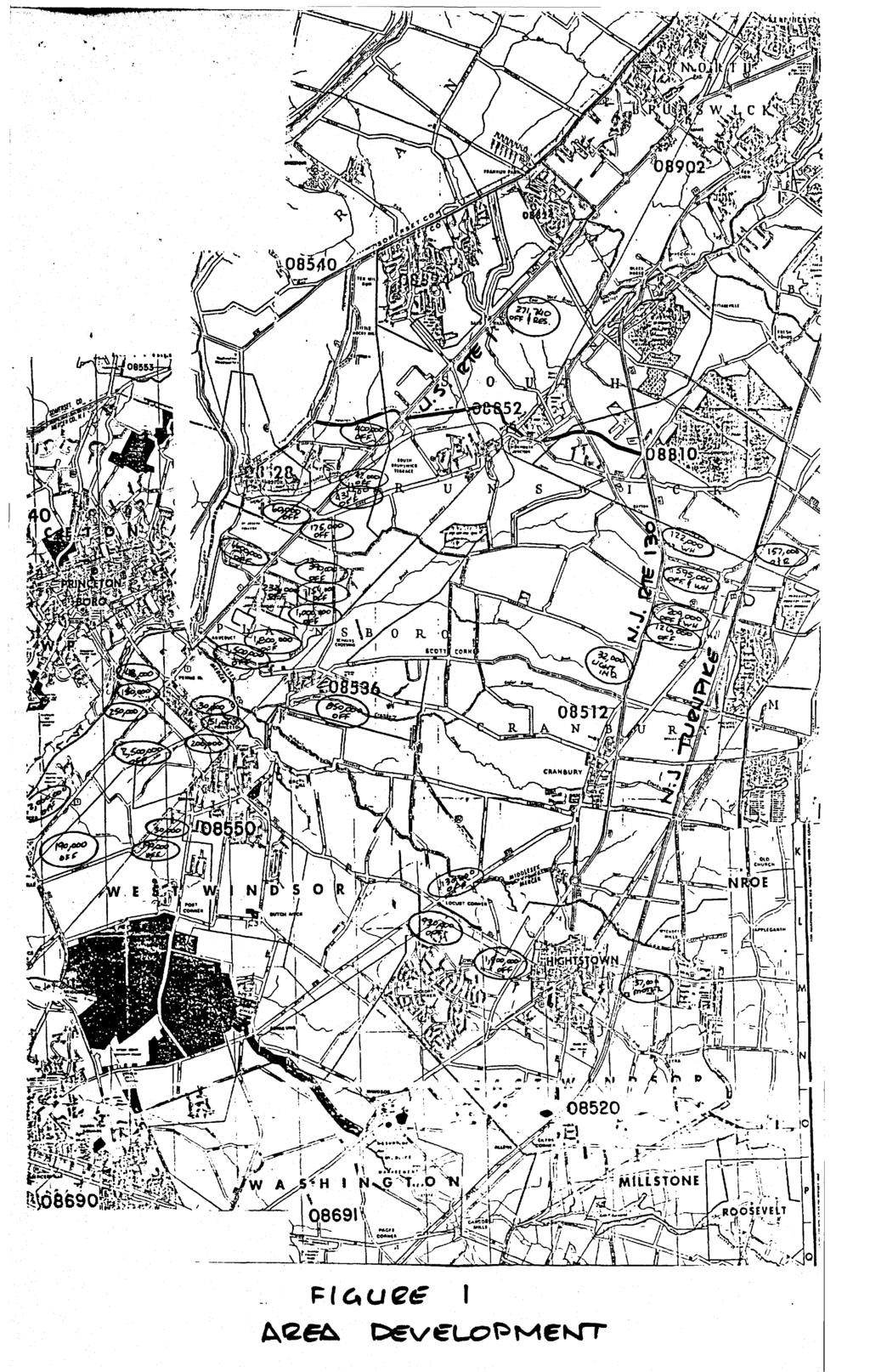
5
6 Page -5- As can be seen from Figure 1, the Route 1 corridor represents the substantial growth area from the standpoint of industrial and commercial activity. With respect to Site 6, Plainsboro-Cranbury Road provides direct access to the Route 1 corridor without the need to traverse the Historic Village area of Cranbury Township. It is this firm's judgment that the majority of site generated traffic will be drawn in a westerly direction as a result of the extensive Route 1 corridor development. It is estimated that approximately 50% of site generated traffic will be oriented toward the Route 1 corridor. Twenty-five (25%) percent of site generated traffic is anticipated to be oriented toward the New Jersey Turnpike and Monroe Township area, with 10% oriented toward East Windsor Township, and the remaining 15% oriented to the south and west toward the West Windsor area. With respect to the impact on the Historic Village of Cranbury, it is anticipated that only the 10% of site generated traffic oriented toward the East Windsor Township area would require the use of roadways traversing the Historic Vi1lage area. Based on studies published nationally by the Institute of Transportation Engineers, as well as research data compiled by this firm, trip generation estimates have been developed for the 1,152 multi-family units proposed. Table I has been prepared to outline this anticipated trip generation. TABLE I Trip Generation A.M. Peak Street Hour P.M. Peak Street Hour ie Out Total Hi Out Total As can be seen from Table I, and as is typical of residential developments, the primary movements will occur as outbound movements during the A.M. Peak Street Hour and inbound movements during the P.M. Peak Street Hour. Based on the site traffic distribution outlined above, the following figure depicts the traffic volumes anticipated to be generated by the proposed development and the orientation of said volumes.
7 TRAFFIC Figure 2 DISTRIBUTION 5^36
8 Page -7- In comparison with other sites considered for Mount Laurel development, particularly those to the east of U.S. Route 130, it is evident that the development along the U.S. Route 1 corridor will tend to pull this traffic to the west and require crossing through the Historic Village of Cranbury Township. It is anticipated that the development of tracts to the east of Route 130 will have a more significant impact on the Historic Village than development of Site 6. As previously mentioned, access to the subject property is anticipated to be provided in the northeasterly corner of the site on Main Street and in the southerly portion of the site, on Plainsboro-Cranbury Road. This interconnected access system will enable much of site generated traffic to circulate through the site and onto the adjacent street system of Cranbury Township, at the same time minimizing the use of Main Street south of the site access location. Figure 3 has been provided to depict the anticipated location of the proposed site access.
9 Figure 3 SITE ACCESS LOCATIONS 5236
10 Page -9- As can be seen from the foregoing, access to Site 6 is such that impacts on the Historic Village area can be minimized. The link provided between Plainsboro-Cranbury Road and North Main Street provides in effect a diversion route enabling a bypass of the downtown area. Although it is not predicted that vast numbers of motorists presently using the downtown area intersections will utilize this diversion route, it is anticipated that some diversions will occur, further reducing overall impacts on the downtown village area. It is also important to consider that although the Department of Transportation has not finalized the Route 92 location, all of the locations presently under consideration would result in accessibility to Route 92 from Site 6, occurring primarily to the west of the site. Although an interchange for Route 92 has been proposed at Cranbury Road, westbound traffic from Site 6 would have more efficient access to Route 1 from Plainsboro-Cranbury Road and would in all probability not use the Cranbury Road interchange. Westbound traffic from sites east of Route 130 would utilize the Cranbury Road interchange with Route 92. Again, the anticipated locations for Route 92 and the development of the Route 1 corridor, as well as the proposed access concept, combine to reduce overall impacts from this site on the Historic Village of Cranbury Township. The downtown area of Cranbury Township provides commercial activity, police and fire services and elementary school services. Of all of the sites under consideration, Site 6 is the only site with significant proximity to the downtown area to foster pedestrian use of the facilities provided. Access to the village area would range from one-half to three-quarters of a mile from the subject property, well within reasonable walking distance for. minor shopping trips. The result of this proximity would be decreased automobile usage from the subject property to the downtown area than could be anticipated from the development of many of the other properties under consideration. It is certain that some additional vehicle movements will be generated through the village area as a result of shopping trips, however, the development of Site 6 lends itself well to minimizing these additional traffic movements. Referring to the Masters Report, "Site 6 is clearly the superior location among the four plaintiff sites" as it relates to pedestrian access. The Masters Report further states that n...this proximity would diminish the residents 1 reliance on the automobile and act to ease the traffic congestion which has been discussed previously."
11 Page -10- In conclusion, the development of Site 6 for 1,152 multi-family units is, in my judgment, a development scheme that will have minimal impacts on the downtown Historic Village of Cranbury Township. My conclusions are summarized as follows: Site generated traffic will be oriented primarily toward the Route 1 corridor, with a secondary impact north of the site toward Monroe, resulting in no impact to the village area. It is estimated that some 10% of site generated traffic may utilize the downtown area to gain access to locations southeast of the site, primarily the East Windsor Township area. This additional traffic volume generated is minor in comparison to the anticipated impact generated by developments east of Route 130 which, in light of the Route corridor distribution, will traverse the village area. o The site development plan calls for a connector road from Plainsboro-Cranbury Road to North Main Street, creating a bypass of the village area. This connector will provide a diversion for some percentage of traffic presently utilizing the village street system to gain access to the Turnpike and points north. The North Main Street access, as proposed, will service traffic oriented to Monroe and the New Jersey Turnpike from the site without the need to traverse the downtown village area. The construction of Route 92 is oriented primarily west of the site, further accommodating a westerly distribution from Site 6. A review of the location of Site 6 as it relates to the village area indicates said site to be particularly suited for pedestrian access to the village area. This should result in a reduced impact on the village from the standpoint of commercial trips. The advantage of this pedestrian access is further supported in the Masters Report. It is therefore my conclusion that Site 6 represents a feasible location for the proposed Mount Laurel units and the development of same will not have a detrimental impact on the Historic Village area of Cranbury Township. Very truly vours, HJN:KPM:ms Henr^Cff. Ney, P.E.
MEMORANDUM. Date: May 31, West Windsor Township Planning Board
 Date: May 31, 2007 MEMORANDUM To: From: Subject: West Windsor Township Planning Board Dan Dobromilsky, Landscape Architect James Parvesse, Township Engineer John Madden, Professional Planner Ted Ehrlich,
2.0 PURPOSE AND NEED. 2.1 Purpose. 2.2 Need Traffic Congestion in and around Downtown Derry
 2.0 PURPOSE AND NEED Taking into consideration agency and public input, the purpose and need for the Project was identified early in Project planning. As noted in Appendix A, for purposes of meeting the
Existing Transportation System 5-1
 5-1 The Jackson County transportation system is served by several modes of transportation including streets and highways, multi-modal, non-motorized, rail, and aviation. While the focus of the transportation
NORTH-SOUTH CORRIDOR STUDY EXECUTIVE SUMMARY. Executive Summary
 Executive Summary Background As congestion continues to affect mobility in the region, the Ozarks Transportation Organization (OTO) is particularly concerned with traffic movement. The North-South Corridor
PREPARED FOR: PLATTEVIEW ROAD CORRIDOR STUDY EXECUTIVE SUMMARY
 PREPARED FOR: PLATTEVIEW ROAD CORRIDOR STUDY EXECUTIVE SUMMARY SEPTEMBER 2016 Introduction The Platteview Road Corridor Study was led by the Metropolitan Area Planning Agency (MAPA) with assistance from
Amendment C146 Melton Planning Scheme Expert Evidence Statement Traffic & Transport Beattys Road, Plumpton
 235 311 Beattys Road, Plumpton 16585REP001C-F 21 November 2016 onemilegrid.com.au 1/59 Keele Street, Collingwood, VIC 3066 (03) 9939 8250 onemilegrid ABN: 79 168 115 679 (03) 9939 8250 1/59 Keele Street
Access Management: An Overview
 Figures 1-5 Below Evolution of development along a highway. In the early stages, land along the road is used for farming with little traffic generated. As time passes, the highway corridor becomes a de
3. Additional driveways may be permitted where determined by the Planning Commission to adequately accommodate traffic or ensure public safety.
 ARTICLE 10 ACCESS MANAGEMENT Section 10.01 Purpose. The purpose of this Article is to protect the substantial public investment in the City s street system by preserving the traffic capacity of existing
MODEL ACCESS MANAGEMENT PLAN MINNESOTA TRUNK HIGHWAY 7 COMPREHENSIVE PLAN AMENDMENT (HUTCHINSON SEGMENT)
") MODEL ACCESS MANAGEMENT PLAN MINNESOTA TRUNK HIGHWAY 7 (HUTCHINSON SEGMENT) COMPREHENSIVE PLAN AMENDMENT INTRODUCTION. The purpose of this plan is to provide consistent access management in the Trunk
MODEL ACCESS MANAGEMENT PLAN MINNESOTA TRUNK HIGHWAY 7 (HUTCHINSON SEGMENT) COMPREHENSIVE PLAN AMENDMENT INTRODUCTION. The purpose of this plan is to provide consistent access management in the Trunk
Bypass #16 - Bend Parkway (new alignment for US 97) (MP )
 (MP )") Bypass #16 - Bend Parkway (new alignment for US 97) (MP 134.76-141.83) Description: The Parkway is on new alignment for US 97 through Bend. US 97 is a Statewide Highway on the National Highway System that
Bypass #16 - Bend Parkway (new alignment for US 97) (MP 134.76-141.83) Description: The Parkway is on new alignment for US 97 through Bend. US 97 is a Statewide Highway on the National Highway System that
Pine Island Road Corridor Master Plan
 RECOMMENDED DEVELOPMENT PLAN Figure 9: Del Prado Village District Conceptual Framework The Conceptual Framework (Figure 8) for development of the Pine Island Corridor is to encourage mixed-use development
Whitehurst Freeway Deconstruction Feasibility Study
 Whitehurst Freeway Deconstruction Feasibility Study Draft Existing Conditions Report Prepared By: For: District Department of Transportation District of Columbia October 2005 TABLE OF CONTENTS 1. INTRODUCTION...1-1
2040 Long Range Transportation Plan
 2040 Long Range Transportation Plan Adopted: April 15, 2013 APPENDIX D HIGHWAY NEEDS PLAN PROJECTS FREDERICKSBURG Existing and Committed Projects Fall Hill Avenue/Mary Washington Blvd. (Fredericksburg)
Evaluation of Strobe Lights in Red Lens of Traffic Signals
 36 TRANSPORTATION RESEARCH RECORD 1495 Evaluation of Strobe Lights in Red Lens of Traffic Signals BENJAMIN H. COTTRELL, JR. Strobe lights are used as a supplement to the red lens to draw the attention
Baumgarten MPUD. Exhibit 3 Evaluation Criteria
 Pursuant to LDC subsections 10.02.13 B, 10.02.08 F and Chapter 3 G. of the Administrative Code, staff s analysis and recommendation to the Planning Commission, and the Planning Commission s recommendation
and services The protection and conservation of environmentally significant and sensitive natural heritage features and functions.
 6. Land Use 6.0 Preamble A healthy and livable city is one in which people can enjoy a vibrant economy and a sustainable healthy environment in safe, caring and diverse neighbourhoods. In order to ensure
Micco Park Village Development
 FOR SALE Call For Pricing Micco Park Village Development Proposed Project Property Details Micco Park Village Development PRICE Call For Pricing A monumental development opportunity of a lifetime! The
BROOKHILL NEIGHBORHOOD MODEL ZONING MAP AMENDMENT PREFACE TO APPLICATION
 BROOKHILL NEIGHBORHOOD MODEL ZONING MAP AMENDMENT PREFACE TO APPLICATION June 15, 2015 Revised: August 1, 2016 I. VISION Brookhill is a proposed community based upon the principles of Albemarle County
Advance Engineering & Surveying PLLC
 Advance Engineering & Surveying, PLLC Consulting in: Civil & Environmental Engineering Land Surveying Land Development 11 Herbert Drive Phone: (518) 698-3772 Latham, N.Y. 12110 Email:ncostape@gmail.com
Alternatives Development Three conceptual alternatives were developed for the Race Road/Jessup Village Planning Study and are described below:
 Race Road/Jessup Village Planning Study (H550601) Project Newsletter Spring 2015 Project Description The Study Team, consisting of staff from Anne Arundel County (Department of Public Works and Department
RE: AMENDMENT C375 GEELONG PLANNING SCHEME 1900 BARWON HEADS ROAD, BARWON HEADS
 Reference: #V157080 14 August 2018 Barwon Heads Lifestyle Group Pty Ltd C/- Best Hooper Lawyers Level 9, 451 Little Bourke Street MELBOURNE VIC 3000 Attention: Mr. Edward Mahony (Lawyer) Dear Edward RE:
4.11 TRAFFIC Existing Conditions Existing Project Site. Existing Street System
 4.11 TRAFFIC This traffic and circulation section is based on a Traffic Impact Study conducted by Linscott Law & Greenspan Engineers, which is provided in full in Appendix F. This traffic analysis has
Transportation Research Center
 Increasing Design Flexibility in the AASHTO Green Book Your Department Name Presentation to AASHTO Subcommittee on Design Doug Harwood, MRIGlobal July 2017 Transportation Research Center Resolution of
BUILDER LOTS FOR SALE
 BUILDER LOTS FOR SALE NORTHERN CULPEPER - 135 ACRES RESIDENTIAL DEVELOPMENT 1256 Old Bridge Road, Amissville, VA 20106 SALE PRICE: $995,000 LOT SIZE: 135+ Acres APN #: Tax Map 2 Parcel 23 ZONING: R-1 ACCESS:
Chapter 1 - General Design Guidelines CHAPTER 1 GENERAL DESIGN GUIDELINES
 CHAPTER 1 GENERAL DESIGN GUIDELINES 1.0 INTRODUCTION This Publication has been developed to provide current, uniform procedures and guidelines for the application and design of safe, convenient, efficient
City Of Sparks Planning Commission Item
 Page 1 of 12 City Of Sparks Planning Commission Item Meeting Date: May17, 2012 Subject: PCN12009, Public Hearing, Consideration and possible action on a Master Plan Amendment and Rezoning request to change
11 May 9, 2012 Public Hearing APPLICANT: KROGER LIMITED PARTNERSHIP I
 REQUEST: Conditional Use Permit (Automobile Service Station (Fuel Sales) ADDRESS / DESCRIPTION: 3901 Holland Drive 11 May 9, 2012 Public Hearing APPLICANT: KROGER LIMITED PARTNERSHIP I PROPERTY OWNER:
Princess Anne Road. Phase VII (CIP 2-195) Citizens Information Meeting
 Citizens Information Meeting") Citizens Information Meeting Princess Anne Road Phase VII (CIP 2-195) Wednesday, May 5, 2004 4:30 PM to 7:00 PM Red Mill Elementary School 1860 Sandbridge Road Virginia Beach, VA Welcome to the Citizens
Citizens Information Meeting Princess Anne Road Phase VII (CIP 2-195) Wednesday, May 5, 2004 4:30 PM to 7:00 PM Red Mill Elementary School 1860 Sandbridge Road Virginia Beach, VA Welcome to the Citizens
SBCAG STAFF REPORT. MEETING DATE: March 17, 2016 AGENDA ITEM: 5I
 SBCAG STAFF REPORT SUBJECT: Cabrillo-UPRR Bridge Project MEETING DATE: March 17, 2016 AGENDA ITEM: 5I STAFF CONTACT: Fred Luna RECOMMENDATION: Authorize the chair to sign a Memorandum of Understanding
Section 1. Executive Summary
 Executive Summary (This page left blank intentionally) Executive Summary Background Economic growth in southern Leavenworth County over the past decade has been strong. As both the number of business and
MASTER DEVELOPMENT DRAINAGE PLAN FOR MONUMENT HEIGHTS
 MASTER DEVELOPMENT DRAINAGE PLAN FOR MONUMENT HEIGHTS DRAINAGE REPORT STATEMENT ENGINEER'S STATEMENT: The attached drainage plan and report were prepared under my direction and supervision and are correct
KANATA CENTRUM 255 KANATA AVENUE OFFICIAL PLAN AMENDMENT ZONING BY-LAW AMENDMENT
 KANATA CENTRUM 255 KANATA AVENUE OFFICIAL PLAN AMENDMENT ZONING BY-LAW AMENDMENT JUNE 2015 PREPARED BY: FOTENN Consultants Inc. 223 Mcleod Street Ottawa, ON K2P OZ8 (613) 730-5709 PREPARED FOR: Kanata
CHAPTER 7: Transportation, Mobility and Circulation
 AGLE AREA COMMUNITY Plan CHAPTER 7 CHAPTER 7: Transportation, Mobility and Circulation Transportation, Mobility and Circulation The purpose of the Transportation, Mobility and Circulation Chapter is to
TOWNSHIP OF WEST WINDSOR
 TOWNSHIP OF WEST WINDSOR EDINBURG VILLAGE SUBCOMMITTEE OF THE PLANNING BOARD EDINBURG VILLAGE CIRCULATION ANALYSIS AND RECOMMENDATIONS ALAIMO GROUP February 20, 2002 F:\HTML FILES\WW_NEW\MASTERPLAN\EDINBURG
9 CITY OF VAUGHAN OFFICIAL PLAN AMENDMENT NO BOCA EAST INVESTMENTS LIMITED
 9 CITY OF VAUGHAN OFFICIAL PLAN AMENDMENT NO. 631 - BOCA EAST INVESTMENTS LIMITED The Planning and Economic Development Committee recommends the adoption of the recommendations contained in the following
Eastern Terminus TECHNICAL MEMORANDUM CENTRAL BROWARD EAST-WEST TRANSIT ANALYSIS BROWARD COUNTY, FLORIDA
 Eastern Terminus TECHNICAL MEMORANDUM CENTRAL BROWARD EAST-WEST TRANSIT ANALYSIS BROWARD COUNTY, FLORIDA FINANCIAL PROJECT ID NUMBER 411189-2-22-01 FLORIDA DEPARTMENT OF TRANSPORTATION DISTRICT 4 Prepared
Issues Requiring Future Study
 Issues Requiring Future Study Transportation planning is an ongoing process that tends to identify new issues as it finds solutions for others. Some issues are so complex that a solution to one problem
Equity and Environmental Justice B. MINORITY, ELDERLY, AND LOW INCOME POPULATIONS IN THE STUDY AREA
 Chapter 16: Equity and Environmental Justice A. INTRODUCTION The proposed project alternatives would traverse a large study area that contains a wide range of neighborhoods, residents, and workers. The
OVERVIEW OF PLANS FOR THE JEFFERSON COUNTY COUNTRYSIDE FARM In the Context of Quality Place Characteristics
 OVERVIEW OF PLANS FOR THE JEFFERSON COUNTY COUNTRYSIDE FARM In the Context of Quality Place Characteristics By Steve Grabow, Professor and Community Development Educator University of Wisconsin-Extension,
PUBLIC OPEN HOUSE SEPTEMBER 8 TH, 2010 CITY OF LETHBRIDGE DEVELOPMENT SERVICES
 PUBLIC OPEN HOUSE SEPTEMBER 8 TH, 2010 CITY OF LETHBRIDGE DEVELOPMENT SERVICES INTRODUCTION Why is the City creating the West Lethbridge Employment Centre Area Structure Plan? West Lethbridge Urbanization
ANTONIO R. VILLARAIGOSA MAYOR. Transmitted herewith, is the City Engineer's report dated September 28, 2006 for Council review and approval of:
 BOARD OF PUBLIC WORKS MEMBERS CYNTHIA M. RUIZ PRESIDENT VALERIE LYNNE SHAW COMMISSIONER YOLANDA FUENTES COMMISSIONER DAVID SICKLER COMMISSIONER - c.tv OF LOS ANGELt:S CALIFORNIA DEPARTMENT OF PUBLIC WORKS
14 October 10, 2012 Public Hearing APPLICANT: MPB, INC
 14 October 10, 2012 Public Hearing APPLICANT: MPB, INC PROPERTY OWNER: MUNDEN & ASSOCIATES, LP STAFF PLANNER: Karen Prochilo REQUEST: Conditional Change of Zoning (AG-1 & AG-2 to Conditional O-2) ADDRESS
Further input invited as Colchester Growth Strategy nears final phase
 IUE 3 / NOVEMBER 2015 Further input invited as Colchester Growth trategy nears final phase trathcona County is seeking public feedback as it enters the final phase of work on a Growth Management trategy
LAND USE OVERVIEW WHAT YOU WILL FIND IN THIS CHAPTER
 LAND USE WHAT YOU WILL FIND IN THIS CHAPTER Information about the City s expected population and employment growth. Description and capacity of existing and future land use designations. Policies that
2014 PSPE Philadelphia Chapter Outstanding Engineering Achievement Award Nomination
 2014 PSPE Philadelphia Chapter Outstanding Engineering Achievement Award Nomination Route 29 Roadway Improvement Project SR 0029, Section AL2 Charlestown Township, Chester County, PA Nomination Form Route
OP Council Resolution June 16, Planning and Development Services
 OP-08-01 Council Resolution June 16, 2008 Planning and Development Services Kingsgate Landing Outline Plan Table of Contents 1.0 Introduction 1 1.1 Purpose of Plan 1 1.2 Plan Area Location 1 1.3 Ownership
Integrating Land Use and Transportation
 FEATURE Integrating Land Use and Transportation For years the transportation profession has emphasized mobility in the development of plans, programs, and projects. This emphasis on mobility moving people
GENERAL LAND USE PLAN ELEMENT
 CITY OF Prepared by City of Medford Planning Department 200 South Ivy Street Medford, Oregon 97501 plnmed@ci.medford.or.us James E. Huber, AICP, Planning Director COMPREHENSIVE PLANNING SECTION John Adam,
Services Department B September 10, 2007
 Report To: Development Services Committee Item: Date of Report: DS-07-246 September 5, 2007 From: Commissioner, Development File: Date of Meeting: Services Department B7200-0001 September 10, 2007 Subject:
2. AGENCY COORDINATION AND PUBLIC INVOLVMENT
 2. AGENCY COORDINATION AND PUBLIC INVOLVMENT This chapter discusses the process carried out for conducting agency coordination and public involvement activities. TECHNICAL ADVISORY COMMITTEE A Technical
I. DESCRIPTION OF PROPOSED ACTION... 1 A. General Description... 1 B. Historical Resume and Project Status... 2 C. Cost Estimates...
 PROJECT COMMITMENTS SUMMARY... S-1 1. Type of Action... S-1 2. Description of Action... S-1 3. Summary of Purpose and Need... S-1 4. Alternatives Considered... S-2 5. NCDOT Alternatives Carried Forward...
Hastings Area Roadway System Study. February 2009
 Hastings Area Roadway System Study February 2009 TABLE OF CONTENTS EXECUTIVE SUMMARY... iii I. INTRODUCTION & BACKGROUND... 1 A. STUDY GOAL & STUDY AREA... 1 B. NEED FOR STUDY... 1 C. AGENCY COORDINATION
RESOLUTION NO R
 e e RESOLUTION NO R04 0054 BE IT RESOLVED by the Mayor and City Council ofthe City ofpapillion that The Papillion Comprehensive Plan is hereby amended to incorporate the Option A Future Land Use Map Transportation
D3 January 14, 2015 Public Hearing
 D3 January 14, 2015 Public Hearing APPLICANT: DONALD J. BOUCHER, JR. PROPERTY OWNER: D.J.B. SERVICE CENTER, LLC STAFF PLANNER: Kristine Gay REQUEST: A. Conditional Change of Zoning (I-1 to B-2) B. Conditional
A raised and landscaped median will be constructed in South College Avenue between Trilby Road and Skyway Drive.
 5.0 ACCESS CONTROL PLAN This section presents the Access Control Plan Update which has been formulated through the considerable input of the governing agencies, business owners, organized homeowner groups,
Request for Statement of Interest in Implementation of the Roosevelt Road Redevelopment Plan
 425 Hillside Avenue Request for Statement of Interest in Implementation of the Roosevelt Road Redevelopment Plan I. INTRODUCTION The is seeking the services of a qualified consulting firm to prepare plans
Date: April 10, 2017 City Council Work Session April 24, 2017: Status Report on the Comprehensive Plan Update and Transportation Master Plan
 AGENDA REPORT To: From: By: Honorable Mayor and City Council Members Warren Hutmacher, City Manager Sharon Ebert, Director Community Development Date: April 10, 2017 Agenda: City Council Work Session April
Chapter V-Transportation
 Town of Vernon 2026 Smart Growth Plan Chapter V-Transportation DEVELOPMENT OBJECTIVES Transportation System Objective - To provide an integrated transportation system which, through its location, capacity,
ARLINGTON COUNTY, VIRGINIA. County Board Agenda Item Meeting of January 28, 2017 SUPPLEMENTAL REPORT
 ARLINGTON COUNTY, VIRGINIA County Board Agenda Item Meeting of January 28, 2017 SUPPLEMENTAL REPORT DATE: January 26, 2017 SUBJECT: The Virginia Department of Transportation s Transform I-66 Inside the
5.1 Site Plan Guidelines
 5. Community Core Guidelines Development of the Community Core will take place by plan of subdivision and site plan approval. It will occur in a phased manner that will reflect the timing of residential
E. RURAL COMMERCIAL/INDUSTRIAL PARK MODEL
 E. RURAL COMMERCIAL/INDUSTRIAL PARK MODEL 1. PURPOSE The purpose of the Rural Commerce/Industrial Park Model is to provide parameters within which a grouping of business buildings with parking, loading
Definitions. Average Daily Traffic Demand (ADT): The actual number or projected number of cars that pass a point in a 24-hour period.
: The actual number or projected number of cars that pass a point in a 24-hour period.") Definitions Access Management: A combination of physical techniques and transportation policies used to control the flow of traffic between roads and the surrounding lands. Alternative City Form Scenarios:
Definitions Access Management: A combination of physical techniques and transportation policies used to control the flow of traffic between roads and the surrounding lands. Alternative City Form Scenarios:
4.1.3 LAND USE CATEGORIES
 4.1.3 LAND USE CATEGORIES a. City Center District The City Center District incorporates the existing character and mix of uses in downtown Belmont to encourage redevelopment and new development in keeping
GDP BOUNDARY Christopher A. Brooks, PLS for and on behalf of Matrix Design Group, Inc. VICINITY MAP SCALE: N.T.S.
 COVER SHEET I, Christopher A. Brooks, a Registered Land Surveyor in the State of Colorado, do hereby certify that the description as shown on Sheet 2, for the Buckley Annex General Development Plan was
Review of Opportunity Area C Draft Comprehensive Plan and Draft BOS Follow-On Motions. Special Working Group Meeting March 4, 2015
 Review of Opportunity Area C Draft Comprehensive Plan and Draft BOS Follow-On Motions Special Working Group Meeting March 4, 2015 The slides that follow identify where the draft Comprehensive Plan has
ITEM #8. Regional Smart Growth Program. Regional Smart Growth Program. Presentation Overview. Coast Highway Vision and Stategic Plan.
 Regional Smart Growth Program Economic Development Commission What is Smart Growth? Adopted as part of the Regional Comprehensive Plan (RCP) RCP provides vision for region based on Smart Growth and sustainability
include playgrounds, sports fields, community gardens and picnic areas.
 DEVELOPMENT PLAN OPEN SPACE SYSTEM OPEN SPACE SYSTEM The neighborhood provides for a range of open space types. The Village Square is an important open space in the neighborhood. It serves as a gathering
Regency Developments. Urban Design Brief. Holyrood DC2 Rezoning
 Regency Developments Urban Design Brief Holyrood DC2 Rezoning Stantec Consulting Ltd. 7-31-2017 1. Overview Regency Developments intends to rezone the lands located at 8510 and 8511 93 Avenue, within the
NOTE: PLEASE REFER TO MISSISSAUGA PLAN FOR ADDITIONAL CITY-WIDE POLICIES WHICH APPLY TO THIS DISTRICT.
 NOTE: THE POLICIES IN THIS DOCUMENT ARE SPECIFIC TO THE FAIRVIEW PLANNING DISTRICT OF, AND MUST BE READ IN CONJUNCTION WITH ALL THE POLICIES OF PLEASE REFER TO FOR ADDITIONAL CITY-WIDE POLICIES WHICH APPLY
Transportation. Strategies for Action
 Transportation A major priority for the Overlake Neighborhood is to develop a multimodal transportation system. To achieve this system, a balance has to be found among travel, circulation and access needs;
Right-of-Way Acquisitions and Relocations Technical Memorandum
 Right-of-Way Acquisitions and Relocations Technical Memorandum Southeast Extension Project Lincoln Station to RidgeGate Parkway Prepared for: Federal Transit Administration Prepared by: Denver Regional
AWH REPORT OF THE PLANNING AND DEVELOPMENT DEPARTMENT FOR APPLICATION FOR REZONING ORDINANCE TO PLANNED UNIT DEVELOPMENT
 AWH REPORT OF THE PLANNING AND DEVELOPMENT DEPARTMENT FOR APPLICATION FOR REZONING ORDINANCE TO PLANNED UNIT DEVELOPMENT MAY 8, 2014 The Planning and Development Department hereby forwards to the Planning
Economic Development & Housing Council Committee Comprehensive Plan Update September 20, 2005
 1 Economic Development & Housing Council Committee Comprehensive Plan Update September 20, 2005 Purpose To update the Committee on the ForwardDallas! Plan, including: Status Anticipated Products Public
September 25th, 2018 $2000 fee pd CC
 2.7267 acres 2018I-00075 September 25th, 2018 $2000 fee pd CC Rezoning Review Criteria Analysis - Map Amendment Application Number: 2018I-00075 805 W. 38 th Avenue October 19, 2018 (amd.) September 17,
PROJECT STATEMENT LOCATION/DESIGN PUBLIC HEARING. 19 th AVENUE NORTH EXTENSION PROJECT FROM SPRINGDALE DRIVE TO NORTH 2 ND STREET/U.S.
 PROJECT STATEMENT LOCATION/DESIGN PUBLIC HEARING 19 th AVENUE NORTH EXTENSION PROJECT FROM SPRINGDALE DRIVE TO NORTH 2 ND STREET/U.S. 67 HEARING LOCATION: ERICKSEN COMMUNITY CENTER 1401 11 TH AVENUE NORTH
PROTOTYPE DESIGN/INTRODUCTION
 PART III: PROTOTYPE DESIGN These concepts and guidelines described earlier were used to develop a prototype design for an emerging suburban area located west of the City of Milwaukee. This was done to
1.0 INTRODUCTION 1.1 TH 14 WEST STUDY AREA Project Description Functional Classification Purpose of the Project
 1.0 INTRODUCTION 1.1 TH 14 WEST STUDY AREA 1.1.1 Project Description The Trunk Highway (TH) 14 West Corridor is a two-lane roadway approximately 22 miles in length. Located in Nicollet County, the corridor
DRAFT SECTION 4(f) EVALUATION INTERSTATE 73 FEIS: I-95 to I-73/I-74 in North Carolina
 EVALUATION INTERSTATE 73 FEIS: I-95 to I-73/I-74 in North Carolina") DRAFT SECTION 4(f) EVALUATION INTERSTATE 73 FEIS: I-95 to I-73/I-74 in North Carolina 1.0 INTRODUCTION Section 4(f) of the Department of Transportation Act of 1966, 49 U.S.C. 303, requires that prior to
DRAFT SECTION 4(f) EVALUATION INTERSTATE 73 FEIS: I-95 to I-73/I-74 in North Carolina 1.0 INTRODUCTION Section 4(f) of the Department of Transportation Act of 1966, 49 U.S.C. 303, requires that prior to
BACKGROUND, GOALS, STUDY AREA, EVALUATION CRITERIA, ORGANIZATION
 CHAPTER 1 BACKGROUND, GOALS, STUDY AREA, EVALUATION CRITERIA, ORGANIZATION 1.0 INTRODUCTION The Executive Office of Transportation and Public Works Office of Transportation Planning (Planning) initiated
Department of Community Development Engineering Office NJDOT Municipal Aid Program - Cottrell Road Pedestrian Safety
 Department of Community Development Engineering Office Nicole S. Shapiro, PE, PP, CME Director of Community Development & Township Engineer Parminder Sumal, PE, PP, CME Assistant Engineer MEMO TO: Mayor
Executive Summary. NY 7 / NY 2 Corridor
 Executive Summary NY 7 / NY 2 Corridor Transportation and Land Use Study December 2005 Prepared for: Town of Colonie Capital District Transportation Committee Prepared by: Introduction: Land use decisions
Director, Community Planning, Toronto and East York District
 Lower Yonge Precinct Plan Update STAFF REPORT ACTION REQUIRED Date: October 16, 2012 To: From: Wards: Reference Number: Toronto and East York Community Council Director, Community Planning, Toronto and
East River Waterfront Esplanade and Piers New York, New York Draft Environmental Impact Statement
 East River Waterfront Esplanade and Piers New York, New York Draft Environmental Impact Statement October 12, 2006 CEQR No.: TO COME ULURP Nos.: TO COME Lead Agency: Lower Manhattan Development Corporation
DOWNTOWN JACKSONVILLE MASTER PLAN S T R E E T H I E R A R C H Y
 DOWNTOWN JACKSONVILLE MASTER PLAN S T R E E T H I E R A R C H Y Gateway Intra-District Business Inter-District 44 CELEBRATING THE RIVER: A PLAN FOR DOWNTOWN JACKSONVILLE The Transportation Network This
CHAPTER 2 SUMMARY 1. PROJECT SUMMARY DATA
 CHAPTER 2 SUMMARY This is an Initial Study format used to determine, pursuant to CEQA Guidelines Section 15177, whether a project 1) is within the scope of a Master EIR (MEIR), 2) may result in additional
PORT UNION VILLAGE COMMUNITY SECONDARY PLAN
 4 PORT UNION VILLAGE COMMUNITY SECONDARY PLAN 4. PORT UNION VILLAGE COMMUNITY SECONDARY PLAN The following policies and principles apply to the area herein referred to as Port Union Village, as outlined
ARTICLE VI: SITE PLAN REVIEW
 Section 6.01 - Site Plan Review (All Districts) ARTICLE VI: SITE PLAN REVIEW Site plans give the Planning commission an opportunity to review development proposals in a concise and consistent manner. The
Outline Plan in Belvedere (Ward 9) at Street SE, LOC (OP)
 at Street SE, LOC (OP)") 2018 October 04 Page 1 of 12 EXECUTIVE SUMMARY This outline plan application was submitted by B&A Planning Group on 2016 July 15, on behalf of Tristar Communities Inc. for 50.14 hectares (123.89 acres)
2018 October 04 Page 1 of 12 EXECUTIVE SUMMARY This outline plan application was submitted by B&A Planning Group on 2016 July 15, on behalf of Tristar Communities Inc. for 50.14 hectares (123.89 acres)
MEMORANDUM. California State University Channel Islands Evacuation Planning Analysis
 MEMORANDUM Date: To: From: Subject: Maggie Tougas, Cary Bearn & Miguel Nunez, AICP Evacuation Planning Analysis LA17-2966 This memorandum was prepared to assist (CSUCI) with evacuation planning at the
12 January 12, 2011 Public Hearing APPLICANT: TAILWIND DEVELOPMENT GROUP,LLC PROPERTY OWNER: CITY OF VIRGINIA BEACH
 12 January 12, 2011 Public Hearing APPLICANT: TAILWIND DEVELOPMENT GROUP,LLC PROPERTY OWNER: CITY OF VIRGINIA BEACH STAFF PLANNER: Faith Christie REQUEST: Conditional Change of Zoning (from PD-H1 Planned
Scope of Services. River Oaks Boulevard (SH 183) Corridor Master Plan
 Corridor Master Plan") Scope of Services River Oaks Boulevard (SH 183) Corridor Master Plan PROJECT AREA The project area consists of the River Oaks Boulevard (SH 183) corridor bounded by SH 199 at the northern end and the Trinity
Scope of Services River Oaks Boulevard (SH 183) Corridor Master Plan PROJECT AREA The project area consists of the River Oaks Boulevard (SH 183) corridor bounded by SH 199 at the northern end and the Trinity
Public Information Centre #1
 and Highway 401 Interchange Improvements WELCOME Public Information Centre #1 Veterans Memorial Parkway Extension and Highway 401 Interchange Improvements Study May 23, 2012 4 p.m. to 7 p.m. Brief Overview
NEIGHBORHOODS ELEMENT
 PREPARED BY CITY OF MEDFORD PLANNING DEPARTMENT 200 SOUTH IVY STREET MEDFORD, OREGON 97501 ROBERT O. SCOTT, AICP, PLANNING DIRECTOR COMPREHENSIVE PLANNING SECTION MARK GALLAGHER, AICP, PRINCIPAL PLANNER
ARLINGTON COUNTY, VIRGINIA. County Board Agenda Item Meeting of January 28, 2017 SUPPLEMENTAL REPORT-2
 ARLINGTON COUNTY, VIRGINIA County Board Agenda Item Meeting of January 28, 2017 SUPPLEMENTAL REPORT-2 DATE: January 27, 2017 SUBJECT: The Virginia Department of Transportation s Transform I-66 Inside the
TRANSPORTATION ELEMENT GOALS, OBJECTIVES, AND POLICIES
 TRANSPORTATION ELEMENT GOALS, OBJECTIVES, AND POLICIES GOAL 2 The City shall provide a safe, convenient, effective, and energy efficient multimodal transportation system which is coordinated with the Future
Be it enacted by the Town Board of the Town of Guilderland that the following new A (Transit Oriented Development (TOD) District) is adopted:
 District) is adopted:") Local Law No. 4 of 2018 (Adoption of 280-18A (Transit Oriented Development District) Be it enacted by the Town Board of the Town of Guilderland that the following new 280-18A (Transit Oriented Development
Local Law No. 4 of 2018 (Adoption of 280-18A (Transit Oriented Development District) Be it enacted by the Town Board of the Town of Guilderland that the following new 280-18A (Transit Oriented Development
WEST HILL BUSINESS PARK AREA STRUCTURE PLAN
 MUNICIPAL DISTRICT OF PEACE NO. 135 WEST HILL BUSINESS PARK AREA STRUCTURE PLAN Prepared by: TABLE OF CONTENTS 1.0 Introduction... 1 1.1 Purpose of Plan........ 1 1.2 Plan Area..... 1 1.3 Existing Conditions...
New Auburn Village Center Study Auburn, Maine
 Auburn, Maine Option Review Summary Prepared for: Androscoggin Transportation Resource Center and City of Auburn Prepared by: T.Y. Lin International MRLD October 10, 2013 1. Introduction This memo summarizes
SHEFFIELD PARK Paulding County, GA DRI #588
 SHEFFIELD PARK Paulding County, GA DRI #588 Supplemental Information for RDC s DRI (Form 2) Review August 16, 2004 Prepared for: Mr. David Howerin Coosa Valley RDC 1 Jackson Hill Drive Rome, GA 30161 P.O.
Ref: March 21, Ms. Jody Kablack Director of Planning and Community Development Town of Sudbury 278 Old Sudbury Road Sudbury, MA 01776
 35 New England Business Center Drive Suite 140 Andover, MA 01810-1066 Office: 978-474-8800 Fax: 978-688-6508 Web: www.rdva.com Ref: 7198 Director of Planning and Community Development Town of Sudbury 278