Part 4.25 Pasminco Area Plan
|
|
|
- Rosanna Marshall
- 5 years ago
- Views:
Transcription


 Industrial (Core) to 2(1)")

1 1 INTRODUCTION The purpose of this Area Plan is to guide the redevelopment of the former Pasminco Cockle Creek Smelter site and the former Incitec Pivot Fertilizer site. The Pasminco and Incitec sites are located north of the historic village of Boolaroo, between Cockle Creek and Munibung Hill. 1.1 EXTENT OF AREA PLAN This Area Plan currently only applies to land shown in Figure 1, and includes deferred land. The deferred land is subject to Draft Amendment No. 83 to Lake Macquarie Local Environmental Plan (LM LEP) 2004 that proposes to rezone the land from 4(1) Industrial (Core) to 2(1) Residential. The Area Plan will apply to the deferred land, once Draft Amendment No. 83 to LM LEP 2004 has been gazetted, and the land has been rezoned 2(1) residential under LM LEP Figure 1 - Extent of Area Plan Page 1 F2011/00731
2 1.2 HISTORY The Pasminco Cockle Creek Smelter site and Incitec Pivot Fertilizer site are located within the traditional country of the Awabakal people. European settlement of the land began in the s and consisted of small-scale agriculture and coal mining. Industrial activities commenced in the 1890s and included lead smelting and fertiliser production. Industrial activities ceased on the Pasminco site in 2003, and the Incitec site in EXISTING CHARACTER Topography The topography varies between 1.5m to 160m above sea level and includes low-lying land adjacent to Cockle Creek and ridgelines associated with Munibung Hill. Cockle Creek and Munibung Hill are both culturally important landscapes to the Awabakal people. Munibung Hill also has high scenic values. Activities and Uses The Pasminco Cockle Creek Smelter site and Incitec Pivot Fertilizer site predominantly consist of cleared, former industrial land. Part of the Pasminco Cockle Creek Smelter site includes remnant native vegetation with significant biodiversity values. Built form The majority of the industrial buildings and equipment associated with the two sites has been demolished. The only exception is the former Pasminco laboratory building which is a listed heritage item. Transport Network Main Road, T.C. Frith Avenue and Munibung Road provide vehicle access to the Pasminco Cockle Creek Smelter site. First Street provides vehicle access to the Incitec Pivot Fertilizer site The Cockle Creek railway station is located north of the Pasminco Cockle Creek Smelter site and provides train services to Newcastle and Sydney. Bus services to Warners Bay and Newcastle (via Glendale) are accessible from Boolaroo. A pedestrian link is located along Main Road and T.C. Frith Avenue (north of Main Road), and provides access between Boolaroo and Argenton. However, the pedestrian link is not completely paved along T.C. Frith Avenue and pedestrian access from Main Road to T.C. Frith Avenue is constrained by high traffic volumes. A road refuge to facilitate road crossings is not provided. 1.4 ENVIRONMENTAL CONSTRAINTS Land Contamination The Pasminco Cockle Creek Smelter site and Incitec Pivot Fertilizer site are declared remediation sites under the Contaminated Land Management Act Remediation is subject to project approvals under Section 75J of the Environmental Planning and Assessment Act (EP&A Act) Remediation will include excavation of contaminated material and placement into a containment cell (hazardous waste storage facility) on the Pasminco site. The containment cell will store the contaminated material indefinitely and will require long-term management and maintenance. Several bushland areas (Angophora inopina Reserve and Munibung Hill Reserve) will not be completely remediated and will also require long-term management and maintenance. Restrictions on the use of ground water may also apply across the site. The containment cell will be retained in private ownership, and Angophora inopina Reserve and Munibung Hill Reserve are anticipated to be retained in private ownership. Implementation of long-term management plans for the containment cell, Angophora inopina Reserve and Munibung Hill Reserve are necessary to ensure that these areas do not re-contaminate the surrounding land, proposed to be used for residential housing and business development. Note: Council will not accept ownership or management responsibility for the containment cell, or any land that is contaminated, including roads or stormwater infrastructure. Council will not consider accepting Page 2 F2011/00731
3 ownership or management responsibility of Angophora inopina Reserve and Munibung Hill Reserve unless management plans have been prepared and implemented to the satisfaction of Council. 2 DESIRED FUTURE CHARACTER Desired Urban Structure It is envisaged that the site will be remediated and redeveloped to provide residential and employment areas which: respect the cultural value of Munibung Hill to the Awabakal people; recognise the history of the industrial activity in the area; integrate future development into the existing urban and natural environment; reinforce the existing character of Main Road and the village of Boolaroo; enhance the natural environment such as watercourses and biodiversity values including native flora species Angophora inopina; retain and enhance the scenic amenity and significance of Munibung Hill; provide a range of choice in housing types; and encourage walking and cycling and facilitate the use of public transport. An urban structure map and a cycleway, heritage and open space map outlining the desired future character is presented in Figure 2 and Figure 3. The key elements of the urban structure map include: integration industrial heritage values, the containment cell and remediated land into the existing urban fabric; a range of residential lands consisting of low to medium density residential development, and employment lands for mixed use and light industrial development; new environmental conservation and Aboriginal heritage areas including the establishment of Angophora inopina Reserve and Munibung Hill Reserve; and transport upgrades and linkages within the site and surrounding area. Desired Urban Character (Key transport and landuse interface areas only) The intersection of Main Road and First Street: Residential development located adjacent to the intersection of Main Road and First Street should complement the streetscape and built form of the Boolaroo Heritage Precinct. Residential development should be two storeys high to match the scale of adjoining commercial development. Residential development should be designed with building frontages and entries clearly addressing either Main Road or First Street. Windows of habitable rooms should overlook Main Road or First Street. Front fencing should not exceed 1.2m high. Main Road: Residential development should be designed with building frontages and entries clearly addressing Main Road. Windows of habitable rooms should overlook Main Road. Front fencing should not exceed 1.2m high. If site grades on the western-side of Main Road constrain development from addressing the street, a landscaped buffer area should separate residential development from Main Road. The indicative location of the landscape buffer is shown in Figure 2. An indicative cross section of Main Road with a landscape buffer is provided in Figure 4. Rear fencing of residential development adjoining Main Road must be consistent along the entire length of Main Road. Sheet steel fencing is not acceptable. The fencing design must be resolved at subdivision stage and be compatible with noise attenuation requirements. T.C. Frith Avenue and Munibung Road: Residential development along T.C. Frith Avenue and Munibung Road should be separated by a landscaped buffer and local road as shown indicatively in Figure 2. Building frontages and entries should clearly address local road. Windows of habitable rooms should overlook the local road. Front fencing should not exceed 1.2m high. An indicative cross section of T.C. Frith Avenue and Munibung Road is provided in Figure 4. Page 3 F2011/00731


4 Residential / Industrial Interfaces: Residential development south of Munibung Road should be separated from light industrial development by a landscape buffer and a local road as shown indicatively in Figure 2. Building frontages and entries should clearly address the local road. Windows of habitable rooms should overlook the local road. An indicative cross section of the landscape buffer and local road is shown in Figure 4. Rear fencing of industrial properties must be consistent. Sheet steel fencing is not acceptable. Residential / Riparian and Detention Basin Interfaces: Residential lots should be separated from riparian linkages and detention basins by a local road as shown in Figure 5. Residential buildings should be designed with windows of habitable rooms overlooking riparian linkages and detention basins. Residential lots must not be designed with rear boundaries and fences adjoining riparian linkages and detention basins. Riparian linkages and detention basins should be landscaped and provide opportunities for passive recreation and vehicle access for ease of maintenance. Figure 2 - Urban Structure Map Page 4 F2011/00731


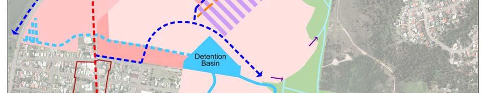
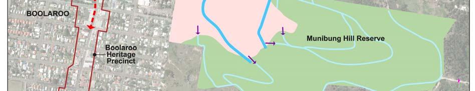
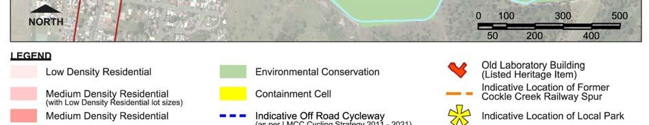
5 Figure 3 - Cycleway, Heritage and Open Space Map Page 5 F2011/00731
6 Figure 4 - Indicative Cross-sections of Selected Roads Note: Landscape buffer plantings should consist of large trees, with a low maintenance understorey or grass, and must be determined in consultation with Council. Page 6 F2011/00731
7 Figure 5 - Indicative residential development interface with riparian linkages and detention basins Page 7 F2011/00731
8 3 CONTAMINATION 3.1 CONTAMINATED LAND a. To ensure land surrounding the containment cell, Angophora inopina Reserve and Munibung Hill Reserve is not subject to contamination risk and is suitable for development in accordance with 79C(c) of the EP&A Act Note: Contamination risk includes contaminating substances moving from the containment cell, Angophora inopina Reserve and Munibung Hill Reserve onto surrounding land. Refer to Section 4.3 of the Managing Land Contamination: Planning Guidelines SEPP 55 Remediation of Land for further details on contamination risk. 1 Consent to subdivide land surrounding the containment cell into standard mixed use, commercial or residential lots must not be granted until a long-term management plan for the containment cell has been prepared and implemented to the satisfaction of Council. 2 Consent to subdivide residential land located adjacent to Angophora inopina Reserve and Munibung Hill Reserve into standard residential lots must not be granted until long-term management plans for these areas have been prepared and implemented to the satisfaction of Council. Note: 1 and 2 do not apply to the subdivision of land into super lots. 3.2 CONTAINMENT CELL a. To provide physical separation between the containment cell and adjacent land uses. b. To provide an access road around the cell. c. To provide passive surveillance of the containment cell. d. To prevent erosion on the site and promote visual integration of the containment cell into the landscape character of Munibung Hill. e. To ensure appropriate levels of public access and signage to the containment cell. f. To ensure the public are not exposed to contaminated material. 1. A road must be provided around the perimeter of the containment cell. 2. The perimeter road must not be located within the containment cell lot. 3. The perimeter road must be located on a separate road reserve in public ownership. 4. Buildings adjacent to the containment cell must be oriented and designed to provide passive surveillance of the containment cell. 5. A landscape master plan must be prepared for the containment cell and should be consistent with the following requirements: i. the top of the containment cell should be grassed; ii. the slopes of the containment cell should be vegetated with dense shrubs; iii. a band of informally planted trees should be planted along the perimeter edge of the top of the containment cell; iv. any containment cell infrastructure such as detention basins or swales should be landscaped; and Page 8 F2011/00731
9 v. details of proposed maintenance access points, public access points, public signage and fencing must also be included in the landscape master plan. 6. Any excavation within the containment cell site must be performed in consultation with an accredited land contamination site auditor under the NSW site auditor scheme. 3.3 ANGOPHORA INOPINA RESERVE AND MUNIBUNG HILL RESERVE a. To ensure biodiversity values, bushfire risk and land contamination issues associated with Angophora inopina Reserve and Munibung Hill Reserve are appropriately managed. b. To enhance the existing landscape and scenic qualities of Munibung Hill. c. To ensure residential development is separated from land with bushfire risk, land contamination and biodiversity values. 1 Management plans for the Angophora inopina Reserve and Munibung Hill Reserve must address the following matters: i. the proposed land tenure and managing body for the reserves; ii. the rehabilitation and ongoing management of native vegetation areas; iii. bushfire control, fire trails, weed and feral animal management measures; Note: The location of fire trails should utilise the alignment of existing trails where possible, and connect to the local road network to enable emergency vehicle access. iv. the management and stabilisation of any contaminated soil to prevent public contact and contaminated soil leaving the site including in the event of fire or in stormwater runoff; v. stormwater treatment to ensure contaminated material does not leave the site and contaminate off-site stormwater infrastructure and residential areas; vi. the identification of areas suitable for public access and recreation; vii. proposed buffers, edge treatments and management measures to reduce ongoing impacts and management costs at the interfaces between the reserves, and urban areas; and viii. the establishment of a ridge line native vegetation regeneration link 50m wide as shown in Figure 3. 2 A road must separate residential development from the Angophora inopina Reserve and Munibung Hill Reserve. 3 The road must be located on a separate road reserve in public ownership. 4 SITE ACCESS, MOBILITY AND CONNECTIVITY WITH ADJOINING AREAS a. To create a transport network that provides access, mobility and connectivity within the site and to adjoining areas with regards to vehicles, pedestrians and bicycles. b. To promote development that integrates with the existing subdivision pattern of Boolaroo, the Cardiff Industrial area and Munibung Hill. c. To encourage safe and effective pedestrian and cycle networks. 1 Road links and cycleways should be provided in accordance with Figure 2 and Figure 3. Page 9 F2011/00731
10 2 Primary road linkages must be designed in accordance with the following requirements: i. Munibug Road extension (road reservation and carriageway) must be an industrial road and must include footpaths; ii. All other primary roads are collector roads and must cater for buses; and iii. The proposed intersection between Munibung Road, Main Road and T.C. Frith Avenue must be designed to accommodate safe vehicular, pedestrian and cycle movements. 3 An underground water main located along the eastern side of Main Road (within lot 2 D.P ) should be: i. incorporated into the front setback area of residential development addressing Main Road (the front setback should not be greater than 11m); or ii. relocated into the existing Main Road, road reserve. 4 The local road network in residential areas should be designed to achieve: i. a subdivision pattern consistent with the existing grid subdivision pattern of Boolaroo residential lots and with good solar access; ii. connections with existing local roads to Council s satisfaction; iii. a low speed environment (50 km/h speed zoning); and iv. a walkable and permeable street network avoiding long street blocks. 5 Pedestrian links and cycleways must connect with Cockle Creek Station and the Lake Macquarie bicycle network. A safe pedestrian / cyclist crossing must be provided across T.C. Firth Avenue at a location and type to be determined by Roads and Maritime. 6 The implications of the proposed road network on the efficiency and safety of traffic movement in Boolaroo must be investigated and mitigation measures must be included in any development application that proposes changes to the existing road network. Note: To limit adverse impacts on the existing local road network, traffic management measures may be required to limit traffic volumes entering existing local roads during peak periods. 5 EMPLOYMENT LANDS a. To ensure development on employment related land does not result in unacceptable amenity impacts on surrounding residential or conservations areas. 1. Light industrial development adjacent to residential areas must comply with the following requirements: i. development must not have an unacceptable adverse impact on the amenity of surrounding residential areas by virtue of noise, vibration, air / odour pollution, traffic generation and/or hours of operation; ii. iii. development must be designed to promote the protection of the amenity of surrounding residential areas through a range of measures including appropriate land uses, location of access and parking, use of acoustic screens, and controls on hours of operation; development applications must be accompanied by an acoustic and vibration study establishing that noise criteria for residential amenity and intrusive industrial noise specified in the NSW Industrial Noise Policy (INP) will be achieved at the boundary of the nearest residential property; Page 10 F2011/00731
11 iv. development proposals must ensure that lot size and dimensions are adequate to enable implementation of noise controls; and 2 development adjacent to the Angophora inopina Reserve must incorporate measures that prevent encroachment of industrial activities, weed invasion, and access into the reserve. 6 NOISE ATTENUATION a. To ensure development achieves acceptable levels of amenity in relation to road and rail traffic noise and vibration. b. To ensure any noise walls do not compromise pedestrian / bicycle links and are not a maintenance liability to Council. 1. Subdivision applications for the creation of residential or commercial / mixed use lots adjoining T.C. Frith Avenue, Munibung Road, Main Road and the Great Northern Railway must be accompanied by a detailed acoustic and vibration study prepared to the satisfaction of Council. Acoustic modelling must be based on the proposed subdivision pattern and finished ground levels and include: i. the location and the elevation of noise sources such as vehicles; and ii. the location and elevation of noise receptors such as building windows of new development. 2. Noise acoustic treatments should consist of: i. a continuous building frontage comprising of building facades connected by solid fencing located at least 1m behind the front building line; ii. acoustic treatments to building facades and windows; and iii. the placement of noise sensitive rooms and private outdoor areas away from noise sources. 3. Noise walls should only be provided where the above acoustic treatments cannot achieve levels of acoustic amenity to the satisfaction of Council. 4. Any proposed noise walls must be designed to the satisfaction Council and accompanied by a funded maintenance plan where the noise wall is proposed to be maintained by Council. 5. Bicycle / pedestrian links must be provided through any proposed noise walls. 7 HERITAGE CONSERVATION AND INTERPRETATION a. To acknowledge the value of Munibung Hill to the Awabakal people. b. To conserve, interpret and incorporate industrial heritage as part of future development. c. To encourage development that respects the history of the site s development and former industrial use. d. To retain and adaptively reuse the Old Laboratory Building as a landmark within the site. e. To integrate interpretative material with the emerging urban form. 1. Development must be in accordance with the Heritage Interpretation Plan and the Conservation Management Plan - Former Sulphide Corporation Assay Building, prepared by Graham Brooks and Associates Pty Ltd, November Page 11 F2011/00731
12 Note: An electronic version of the Heritage Interpretation Plan and the Conservation Management Plan is available on request from Council. 2. A site wide Heritage Interpretation Masterplan must be prepared prior to superlot subdivision to ensure a meaningful and consistent approach to the interpretation of heritage matters is achieved across the Pasminco Cockle Creek Smelter site and Incitec Pivot Fertilizer sites. The Heritage Interpretation Strategy must include: i. a schedule of plaques, public artworks, and commemorative displays to be provided across the site; ii. a list of Aboriginal names prepared in consultation with local Aboriginal stakeholders to be used in the naming of parks and reserves; iii. a list of former long serving workers at the Pasminco Cockle Creek Smelter site and Incitec Pivot Fertilizer site to be used in the naming of local streets; and iv. a schedule of salvaged materials from the Pasminco Cockle Creek Smelter and Incitec Pivot Cockle Creek sites that must be incorporated into the design of the landscaping and the public domain in consultation with Council. 3. Development must be in accordance with the site wide Heritage Interpretation Masterplan. 4. Development should ensure that: i. the Old Laboratory building is retained in a prominent location in the site layout and with an appropriate curtilage; ii. the alignment of the former Cockle Creek spur railway line is maintained over most of its length as part of the movement system of the site; and iii. the public domain includes salvaged items from the Pasminco and Incitec sites in landscaping. Note: Refer to Figure 3 for the location of the Old Laboratory building and former Cockle Creek spur railway line. 5. Development that includes plaques, public artworks, commemorative displays and salvaged items must be accompanied by a schedule outlining the ongoing maintenance activities for the items, and the funding arrangements for lifecycle management of the items to the satisfaction of Council. 6. Development of the land associated with the Old Laboratory building must be accompanied by a Heritage Assessment and Statement of Heritage Impact, and must outline: i. appropriate curtilage for the Old Laboratory Building site; and ii. appropriate setbacks and building heights for development adjacent to the Old Laboratory Building. 8 LANDSCAPING AND THE PUBLIC DOMAIN a. To ensure that landscaping recognises and enhances the local character of the area. 1. A landscape plan must be prepared for any landscape buffer between residential development and T.C. Frith Avenue. 2. A streetscape master plan must be prepared for Main Road upgrade and Munibung Road extension. 3. Landscaping adjacent to the Angophora inopina Reserve is to consist of native species grown from local seed. Page 12 F2011/00731
13 4. Landscaping should include salvaged materials from the Pasminco Cockle Creek Smelter site and Incitec Pivot Fertilizer site. Note: For containment cell landscaping requirements refer to Section LOCAL PARK a. To establish a local park in accordance with the desired urban structure for the area. b. To provide for the local recreational needs of future residents and workers. 1. A local park must be established as part of the subdivision of 13A Main Road (Lot 2, D.P ) into standard mixed use, commercial or residential lots. Note: Control 1 does not apply to the subdivision of the land into superlots. 2. The local park must be established to the satisfaction of Council and should be: i. Located in the vicinity of the location shown in Figure 3; ii. iii. iv. 5000m 2 area and be square or rectangular in configuration; Consist of flat land or land with a gentle slope; Have street frontage extending along at least two of the side boundaries; and v. Be fit for purpose for development as a local park and not have any constraints. Page 13 F2011/00731
Part 12 Precinct Area Plans - Wyee West
 TABLE OF CONTENTS 1 INTRODUCTION... 1 1.1 BACKGROUND... 1 1.2 EXTENT OF AREA PLAN... 1 1.3 EXISTING CHARACTER... 2 1.4 ENVIRONMENTAL ATTRIBUTES AND CONSTRAINTS... 2 1.5 DESIRED FUTURE CHARACTER... 3 1.6
I615. Westgate Precinct
 I615. Westgate Precinct I615.1. Precinct Description The Westgate Precinct is located approximately 18km west of the Auckland city centre. There are seven Sub-precincts in the Westgate Precinct: Sub-precinct
Lake Macquarie City. A copy of the published amendment including the instrument and maps, is provided in Attachment 7 of this report.
 Planning Proposal Amendment No. 77 to Lake Macquarie Local Environmental Plan 2004 and proposed Amendment to Draft Lake Macquarie Local Environmental Plan 2013 Minor Zone Boundary Adjustment - Pasminco
Draft Ada Street Cardiff Area Plan
 Draft Ada Street Cardiff Area Plan (Draft Amendment to Lake Macquarie Development Control Plan 2014) Exhibition: The draft Area Plan is on public exhibition from 29 February 2016 to 29 March 2016. Submissions:
I539. Smales 2 Precinct
 I539. Smales 2 Precinct I539.1. Precinct Description The Smales 2 Precinct applies to a 4.8 hectare block of land located on the southern side of Northcote Road and fronting Lake Pupuke, Takapuna. The
4.3 Dudley Area Plan. Introduction. History and Existing Character. Desired Future Character for Dudley
 4.3 Dudley Area Plan Introduction The suburb of Dudley has developed as a result of various circumstances including its topography, history and mineral resources. Dudley development has been identified
Part 10 Town Centre Area Plans Toronto
 CONTENTS: 1 INTRODUCTION... 3 1.1 BACKGROUND... 3 1.2 EXISTING CHARACTER... 4 1.3 ENVIRONMENTAL CONSTRAINTS... 6 1.4 DESIRED FUTURE CHARACTER... 6 2 DEVELOPMENT CONTROLS... 8 2.1 BLOCK CONTROLS... 9 3
Subdivision Design Criteria. Penihana North GUIDELINES TO THE RULES
 Created September 2013 Penihana North Subdivision Design Criteria GUIDELINES TO THE RULES This part of the Plan sets out the design criteria for subdivision in Penihana North. The criteria will be considered
I404 Beachlands 2 Precinct
 I404. Beachlands 2 I404.1. Precinct Description The Beachlands 2 precinct covers approximately 6 hectares of land at the corner of Beachlands and Whitford Maraetai Roads. Its purpose is to provide for
I609. Penihana North Precinct
 I609. Penihana North Precinct I609.1. Precinct description The Penihana North Precinct is located south of the Swanson Railway Station, adjacent to the Rural Urban Boundary (RUB) and Waitakere Ranges Heritage
Development Control Plan
 Development Control Plan Rhodes Corporate Park (Also known as the Digital Site) Development Control Plan Date of Adoption: 4 September 2007 Effective Date: 7 March 2008 Index 1 INTRODUCTION... 3 1.1 LAND
AMENDMENTS. Date Effective. Amendment No. Council. DCP 14 Davidson St, Greenacre Page 2
 AMENDMENTS Amendment No. Description Adopted by Council Date Effective DCP 14 Davidson St, Greenacre Page 2 TABLE OF CONTENTS 1.0 INTRODUCTION... 4 1.1 NAME OF THIS PLAN... 4 1.2 COMMENCEMENT OF DEVELOPMENT
SECTION 7A: WHAKARONGO RESIDENTIAL AREA
 SECTION 7A: WHAKARONGO RESIDENTIAL AREA CONTENTS 7A.1 Introduction 1 7A.2 Resource Management Issues 1 7A.3 Objectives and Policies 1 7A.4 Methods 4 7A.5 Residential Zone 4 7A.5.1 Rules: Controlled Activities
Keystone Business Park Precinct Structure Plan North East Industrial Precinct. Part 2 Design Principles
 Keystone Business Park Precinct Structure Plan North East Industrial Precinct Part 2 Design Principles Context Issues Services Landform Issues Geotech and contamination Ecology Traffic and access Issues
SCHEDULE 10 TO THE URBAN GROWTH ZONE. Shown on the planning scheme map as UGZ10. Truganina Precinct Structure Plan. 1.0 The Plan
 SCHEDULE 10 TO THE URBAN GROWTH ZONE Shown on the planning scheme map as UGZ10 Truganina Precinct Structure Plan 1.0 The Plan Map 1 shows the future urban structure proposed in the Truganina Precinct Structure
Planning Proposal Toronto Road, Booragul. Amendment to Lake Macquarie Local Environmental Plan (LMLEP) 2014
 2014") Planning Proposal Toronto Road, Booragul Amendment to Lake Macquarie Local Environmental Plan (LMLEP) 2014 Local Government Area: Name of Draft LEP: Subject Land: Land Owner: Applicant: Folder Number:
Planning Proposal Toronto Road, Booragul Amendment to Lake Macquarie Local Environmental Plan (LMLEP) 2014 Local Government Area: Name of Draft LEP: Subject Land: Land Owner: Applicant: Folder Number:
Planning Proposal Concurrent DA/LEP Amendment for Belmont North Pharmacy Amendment No. 24 to Lake Macquarie Local Environmental Plan (LMLEP) 2014
 2014") Planning Proposal Concurrent DA/LEP Amendment for Belmont North Pharmacy Amendment No. 24 to Lake Macquarie Local Environmental Plan (LMLEP) 2014 Local Government Area: Name of Draft LEP: Subject Land:
Planning Proposal Concurrent DA/LEP Amendment for Belmont North Pharmacy Amendment No. 24 to Lake Macquarie Local Environmental Plan (LMLEP) 2014 Local Government Area: Name of Draft LEP: Subject Land:
I611. Swanson North Precinct
 I611. Swanson North Precinct I611.1. Precinct Description Swanson North is located in the north eastern foothills of the Waitakere Ranges. It is outside the Waitakere Ranges Heritage Area Act and the Waitakere
I403 Beachlands 1 Precinct
 I403. Beachlands 1 I403.1. Precinct Description Beachlands is a rural and coastal village located on the eastern side of Auckland, adjoining the Tamaki Strait coastline. The original Beachlands village
Next Steps / Development Process. Structure Plan. June submitted to City of Fremantle. Structure Plan. July supported for advertising
 overview What is today about? In July 0, the City of Fremantle resolved that the be advertised for public comment. Today is about: Understanding the history and context of the site Having your say on the
11.3 SPECIAL CHARACTER ZONE HAWKE S BAY REGIONAL SPORTS PARK
 11.3 SPECIAL CHARACTER ZONE HAWKE S BAY REGIONAL SPORTS PARK 11.3.1 INTRODUCTION The availability of sports and recreation activities and facilities is important for the maintenance and enhancement of
Section 12C Subdivision in the Rural Residential Zone
 Section 12C 12C Subdivision in the Rural Residential Zone The Rural Residential Zone provides part of the range of residential opportunities within the City. Land zoned rural residential is considered
The West Vaughan Employment Area Secondary Plan Policies
 Part 2: The West Vaughan Employment Area Secondary Plan Policies 2.1 General Policies It is the policy of Council: 2.1.1. That the West Vaughan Employment Area (the WVEA), identified on Schedule 1, will
4 Residential and Urban Living Zones
 4 Residential and Urban Living Zones Refer to Chapters 11 to 20 for additional rules that may apply to these zones. 4.1 OBJECTIVES AND POLICIES Objective Res1 Policy 1 Policy 2 Policy 3 Policy 4 Policy
Lake Macquarie Development Control Plan 2014 Revision 19
 Lake Macquarie Development Control Plan 2014 Revision 19 Part 8 Subdivision Development Adopted by Council 25 June 218 Page 0 F2018/00436 TABLE OF CONTENTS: 1 INTRODUCTION... 4 1.1 HOW TO USE THIS PLAN...
Cape Cabarita (Formerly known as the Wellcome Site) Development Control Plan. Date of Adoption: 4 September 2007 Effective Date: 7 March 2008
 Development Control Plan. Date of Adoption: 4 September 2007 Effective Date: 7 March 2008") Cape Cabarita (Formerly known as the Wellcome Site) Development Control Plan Date of Adoption: 4 September 2007 Effective Date: 7 March 2008 Development Control Plan Index 1 INTRODUCTION...3 1.1 LAND TO
Cape Cabarita (Formerly known as the Wellcome Site) Development Control Plan Date of Adoption: 4 September 2007 Effective Date: 7 March 2008 Development Control Plan Index 1 INTRODUCTION...3 1.1 LAND TO
QUEENSTOWN LAKES DISTRICT COUNCIL SUBDIVISION DESIGN GUIDELINES
 Attachment C: Draft QLDC Subdivision Design Guidelines QUEENSTOWN LAKES DISTRICT COUNCIL DESIGN GUIDELINES A DESIGN GUIDE FOR AND DEVELOPMENT IN THE URBAN ZONES QUEENSTOWN OFFICE 10 Gorge Road Queenstown
Division 13 Local Business and Industry Buffer Zone: Assessment Criteria and Assessment Tables
 Division 13 Local Business and Industry Buffer Zone: Assessment Criteria and Assessment Tables 4.13.1 Local Business and Industry Buffer Zone The provisions in this division relate to the Local Business
39 WALLACEVILLE STRUCTURE PLAN
 39 WALLACEVILLE STRUCTURE PLAN PRECINCT DESCRIPTIONS, INTENTIONS AND OUTCOMES Wallaceville Living Precinct Area A At approximately 13.4ha, this precinct is the largest precinct and the precinct provides
SCHEDULE THREE TO THE DEVELOPMENT PLAN OVERLAY EASTERN GOLF COURSE KEY REDEVELOPMENT SITE
 DD/MM/YY SCHEDULE THREE TO THE DEVELOPMENT PLAN OVERLAY Shown on the planning scheme map as DPO3 EASTERN GOLF COURSE KEY REDEVELOPMENT SITE 1.0 A permit may be granted before a development plan has been
4 RESIDENTIAL ZONE. 4.1 Background
 4 RESIDENTIAL ZONE 4.1 Background The residential areas within the City are characterised by mainly lowrise dwellings sited on individual allotments. Past architectural styles, settlement patterns and
DAVENPORT VILLAGE SECONDARY PLAN
 27 DAVENPORT VILLAGE SECONDARY PLAN 27. DAVENPORT VILLAGE SECONDARY PLAN 1. VISION FOR THE DAVENPORT VILLAGE SECONDARY PLAN Davenport Village, municipally known as 830, 940, 980 and 1100 Lansdowne Avenue,
URBAN DESIGN BRIEF URBAN DESIGN BRIEF 721 FRANKLIN BLVD, CAMBRIDGE August 2018
 URBAN DESIGN BRIEF URBAN DESIGN BRIEF 721 FRANKLIN BLVD, CAMBRIDGE August 2018 DESIGN BRIEF CONTENTS PART A 1.0 INTRODUCTION 2.0 DESCRIPTION & ANALYSIS OF SITE CONTEXT 3.0 DESIGN CONSTRAINTS AND OPPORTUNITIES
SCHEDULE 12 TO THE DESIGN AND DEVELOPMENT OVERLAY GLEN WAVERLEY ACTIVITY CENTRE STRUCTURE PLAN
 DD/MM/YY Proposed C120 SCHEDULE 12 TO THE DESIGN AND DEVELOPMENT OVERLAY Shown on the planning scheme map as DDO12. GLEN WAVERLEY ACTIVITY CENTRE STRUCTURE PLAN 1.0 Design objectives DD/MM/YY Proposed
NORTH COFFS DEVELOPMENT CONTROL PLAN ABN
 NORTH COFFS DEVELOPMENT CONTROL PLAN ABN 79 126 214 487 CONTENTS PART 1 INTRODUCTION... 1 PREAMBLE... 1 AMENDMENTS... 1 RELATIONSHIP WITH OTHER DCP S... 1 OBJECTIVES... 1 HOW TO USE THIS DCP... 2 PROCEDURES...
Department of Planning
 NSW GOVERNMENT Department of Planning Contact: Sumathi Navaratnam Phone: 02 9228 6361 Fax: 02 9228 6540 E-mail: sumathi.navaratnam@planning.nsw.gov.au Mr Robert Domm Chief Executive Officer Redfern - Waterloo
Chapter 5 Urban Design and Public Realm
 5.1 Introduction Public realm is all areas of the urban fabric to which the public have access. It is where physical interaction takes place between people. It therefore, includes buildings and their design,
Wingecarribee Shire Council
 Connell Wagner Pty Ltd ABN 54 005 139 873 2 Palmer Street North Parramatta New South Wales 2151 Australia Telephone: +61 2 8896 4100 Facsimile: +61 2 9890 3558 Email: cwpar@conwag.com www.conwag.com Moss
I602. Birdwood Precinct
 I602. Birdwood Precinct I602.1. Precinct description The Birdwood Precinct applies to an area west of Don Buck Road and south of Red Hills Road in west Auckland. It incorporates subdivision and development
Memorial Business Park Site. Proposed Future Development. Design guidelines. August
 Memorial Business Park Site Proposed Future Development Design guidelines August 2014 www.designenvironment.co.nz 0064 3 358 3040 Contents 1.0 Background 1.1 Introduction 3 1.2 Objectives 4 2.0 Context
Carter Street Precinct. Development Control Plan 2016
 Carter Street Precinct Development Control Plan 2016 Adopted 13 January 2016 To view an electronic version in PDF format, visit www.planning.nsw.gov.au Crown Copyright 2016 Department of Planning & Environment
Planning Proposal Wangi Power Station Complex Administrative Amendment Lake Macquarie Local Environmental Plan 2014
 Planning Proposal Wangi Power Station Complex Administrative Amendment Lake Macquarie Local Environmental Plan 2014 (Post Exhibition Version) Local Government Area: Name of Draft LEP: Subject Land: Land
North Ryde Station Precinct
 North Ryde Station Precinct Development Control Plan Contents 1 Introduction 1 1.1 Introduction 3 1.2 Name and Application of this Plan 3 1.3 Land to which this Plan applies 3 1.4 Purpose of this Plan
Development Control Plan
 Development Control Plan Liberty Grove Development Control Plan Date of Adoption: 4 September 2007 Effective Date: 7 March 2008 Index 1 INTRODUCTION... 3 1.1 NAME OF PLAN... 3 1.2 AREA TO WHICH THIS PLAN
Authority. any changes required as a result of the approved CHMP.
 PLANNING PERMIT Permit No. Planning Scheme Responsible Authority../2013 Greater Geelong Planning Scheme Greater Geelong City Council ADDRESS OF THE LAND 5, 15, 21, 23, 1/23, 25, 33, 40 and 50 Caddys Road;
THREE PARKS ZONE Three Parks Special Zone The process of applying for resource consents in the zone.
 .25 Three Parks Special Zone The purpose of this zone is to provide for growth and to give effect to the Wanaka 2020 Community (2002) and the more recent Wanaka Structure (2007) and Wanaka Transport Strategy
open space environment
 This section updated August 09 GUIDELINE TO THE RULES The Open Space Environment Rules apply to activities on sites within the Open Space Environment as shown on the Human Environments Maps. Most of the
RURAL ZONE - POLICY. Rural Zone Policy. Issue: Rural Environment. Ruapehu District Plan Page 1 of 8
 Rural Zone Policy RU2 RURAL ZONE - POLICY RU2.1 Introduction The natural resources of the rural environment in the Ruapehu District provide the basis for the existing and potential character, intensity
Wingecarribee Shire Council
 Connell Wagner Pty Ltd ABN 54 005 139 873 2 Palmer Street North Parramatta New South Wales 2151 Australia Telephone: +61 2 8896 4100 Facsimile: +61 2 9890 3558 Email: cwpar@conwag.com www.conwag.com Moss
Planning Proposal Charlestown Swim and Leisure Centre LEP Amendment
 Planning Proposal Charlestown Swim and Leisure Centre LEP Amendment Amendment No. 4 to Lake Macquarie Local Environmental Plan 2014 (PP_2014_LAKEM_005_00) Local Government Area: Name of Draft LEP: Lake
Appendix 1 Structure plan guidelines
 Appendix 1 Structure plan guidelines This appendix forms part of the regional policy statement [rps]. 1.1. Introduction Structure plans are an important method for establishing the pattern of land use
City of Sydney. Sydney Development Control Plan (Harold Park) 2011
 2011") City of Sydney Sydney Development Control Plan (Harold Park) 2011 February 2011 Prepared by City of Sydney This DCP was approved by Council on 14 February 2011 City of Sydney. All rights reserved. No part
City of Sydney Sydney Development Control Plan (Harold Park) 2011 February 2011 Prepared by City of Sydney This DCP was approved by Council on 14 February 2011 City of Sydney. All rights reserved. No part
AOTEA SUPERMARKET ZONE. Zone Introduction
 C18 AOTEA SUPERMARKET ZONE Zone Introduction C18.1 Objective This zone identifies a specific area in Aotea for a stand alone supermarket. The zone is site specific and has a range of objectives, policies
H14. Business General Business Zone
 H14. Business General Business Zone H14.1. Zone description The Business General Business Zone provides for business activities from light industrial to limited office, large format retail and trade suppliers.
MASTER PLAN NO. 60 (SITE DEVELOPMENT PLAN EASTBANK/REGATTA NORTH PRECINCTS 2 4) 2008
 2008") Page 2 TABLE OF CONTENTS PAGE 1 PRELIMINARY... 5 1.1 CITATION... 5 1.2 TYPE OF MASTER PLAN... 5 1.3 LEGAL REQUIREMENT FOR MASTER PLAN... 5 1.4 LEGAL EFFECT OF THE MASTER PLAN... 5 2 DESCRIPTION OF LAND...
Page 2 TABLE OF CONTENTS PAGE 1 PRELIMINARY... 5 1.1 CITATION... 5 1.2 TYPE OF MASTER PLAN... 5 1.3 LEGAL REQUIREMENT FOR MASTER PLAN... 5 1.4 LEGAL EFFECT OF THE MASTER PLAN... 5 2 DESCRIPTION OF LAND...
Sawtell Town Centre Development Control Plan
 Sawtell Town Centre Development Control Plan ABN 79 126 214 487 CONTENTS INTRODUCTION... 1 PREAMBLE... 1 HOW TO USE THIS DCP... 1 LAND TO WHICH THIS PLAN APPLIES... 1 MASTERPLAN... 2 VISION... 2 CHARACTER
Site layout, density and housing type
 Site layout, density and housing type How can the high densities (up to 30 lots/hectare) be justified in this area and protect adjoining neighbourhood character? The overall site density (15-18 lots/ha)
medium desnity housing
 This section updated September 2013 This part of the Plan sets out the assessment criteria for medium density housing. The criteria are designed to give designers and builders flexibility and to provide
AGINCOURT SECONDARY PLAN
 1 AGINCOURT SECONDARY PLAN 1. AGINCOURT SECONDARY PLAN The following policies and principles apply to the area herein referred to as Agincourt, as outlined on Map 1-1. 1. GENERAL POLICIES 1.1 This Secondary
1. Assessment of Environmental Effects
 1. Assessment of Environmental Effects Table of Contents 1. Introduction and Overview 1 2. Statutory Assessment 3 3. Site Description 5 4. Proposal Description 7 5. Assessment of Effects on the Environment
COMMUNITY DESIGN. GOAL: Create livable and attractive communities. Intent
 COMMUNITY DESIGN Intent An attractive, well-designed County will attract quality development, instill civic pride, improve the visual character of the community, and create a strong, positive image for
Section 6A 6A Purpose of the Natural Features and Landscapes Provisions
 Section 6A 6A Purpose of the Natural Features and Landscapes Provisions This Chapter addresses the protection and management of natural features and landscapes within the City. The City has a number of
GREENBANK DEVELOPMENT MASTERPLAN
 DEVELOPMENT MASTERPLAN POTENTIAL TRAIN STATION COMMUNITY CENTRE Greenbank will be a connected masterplanned community providing easy access to local and surrounding amenity. Affordable quality homes, green
REMARKABLES PARK ZONE
 .10 Remarkables Park Zone.10.1 Resources, Activities and Values The Remarkables Park Area comprises approximately 150 hectares of perimeter urban land in the vicinity of Frankton and occupies a strategic
Planning Proposal. Part of the Former Swansea Bowling Club Rezoning at Charles Street and Lake Road, Swansea
 Planning Proposal Part of the Former Swansea Bowling Club Rezoning at Charles Street and Lake Road, Swansea Draft Amendment No. 26 to Lake Macquarie Local Environmental Plan 2014 As Published 16/03/2018
8.0 Design and Form of Development 43/
 42/ 8.0 Design and Form of Development 43/ Rothwells Farm, Golborne/ Development Statement Figure 7. Site Constraints Key 44/ Site Boundary 360 Bus Route/Stops Existing Trees Underground Water Pipe Sensitive
statement of environmental effects
 for single dwelling houses, granny flats and associated ancillary structures only property details Please provide the following details Lot N o/s. Section N o. DP N o. A statement of environmental effects
Lake Macquarie Development Control Plan 2014 Revision 17
 Lake Macquarie Development Control Plan 2014 Revision 17 Part 4 Development in Business Zones Page 0 F2017/00418 Table of Contents: 1 INTRODUCTION... 4 1.1 HOW TO USE THIS PLAN... 4 1.2 ADDITIONAL CONTROLS
64 Mineral Extraction Area Rules
 64 Mineral Extraction Area Rules 64.1 Introduction For the purposes of this Chapter: Active Area, in relation to a Mineral Extraction Area (MEA), is that part of the Mineral Extraction Area which is owned
TIDAPA Structure Plan
 TIDAPA Structure Plan Prepared by Tract Consultants 28 MARCH 2017 0217-0074 Table of Contents 01 STRATEGIC CONTEXT Executive Summary Regional Context Page 3 Page 4 02 LOCAL CONTEXT Aerial Photograph Local
NORTH EAST INDUSTRIAL ZONE
 SECTION 12A: NORTH EAST INDUSTRIAL ZONE CONTENTS 12A.1 Introduction 1 12A.2 Resource Management Issues 2 12A.3 Objectives and Policies 3 12A.4 Rules: Permitted Activities 8 R12A.4.1 Permitted Activities
North Oakville East Parks Facilities Distribution Plan. November, 2009
 North Oakville East November, 2009 POLICY CONTEXT 1) Purpose a) The purpose of this document is to be a guide for the location, configuration, design and development of the parks system for the North Oakville
PORT WHITBY COMMUNITY
 PORT WHITBY COMMUNITY SECONDARY PLAN UPDATE COMMUNITY IMPROVEMENT PLAN URBAN DESIGN GUIDELINES September 2015 DRAFT PROPOSED AMENDMENT NUMBER # to the Whitby Official Plan PURPOSE: The intent of this Amendment
UNIVERSITY TOWN NEIGHBOURHOODS 5.2 ECO-CORRIDOR MELBOURNE CAMPUS MASTER PLAN 2014
 5.2 ECO-CORRIDOR 37 ECO-CORRIDOR EXISTING CONDITIONS & VISION NEIGHBOURHOOD VISION Investment in the Eco-corridor Neighbourhood will signify the University s commitment to supporting local ecology and
I333 Three Kings Precinct
 I333. Three Kings I333.1. Precinct description The Three Kings Precinct provides for the development of a vibrant, sustainable urban village on the former quarries and the adjacent land at Three Kings.
SECTION 2.4 URBAN DEVELOPMENT AND STRATEGIC URBAN DIRECTIONS
 SECTION 2.4 URBAN DEVELOPMENT AND STRATEGIC URBAN DIRECTIONS 2.4.1 INTRODUCTION In 1993/94 the Hastings District Council completed the Hastings Urban Development Strategy. The purpose of this study was:
I412. Flat Bush Precinct
 I412. Flat Bush Precinct I412.1. Precinct description The Flat Bush precinct covers approximately 1730ha of land adjacent to the Rural Urban Boundary. The Flat Bush Precinct incorporates the provisions
Establish a network of streetscaped vehicle and pedestrian routes that connect within and outside the Plan area.
 This Plan s urban design goals are to create an urban scale, walkable community with connections to transit, parks, and services and with amenities and facilities for residents and employees. The 1992
SPECIAL 35 (HIBISCUS COAST GATEWAY) ZONE
 ZONE") `` 12.8.35 SPECIAL 35 (HIBISCUS COAST GATEWAY) ZONE 12.8.35.1 Issues The following provisions relate to the Hibiscus Coast Gateway Zone. This zone is located at Silverdale in the area bounded by State
`` 12.8.35 SPECIAL 35 (HIBISCUS COAST GATEWAY) ZONE 12.8.35.1 Issues The following provisions relate to the Hibiscus Coast Gateway Zone. This zone is located at Silverdale in the area bounded by State
SECTION ONE North East Industrial Zone Design Guide Palmerston North City Council June 2004
 SECTION ONE North East Industrial Zone Design Guide Palmerston North City Council June 2004 young heart easy living 1 Preface Industrial areas are a very important component of the economic well-being
and services The protection and conservation of environmentally significant and sensitive natural heritage features and functions.
 6. Land Use 6.0 Preamble A healthy and livable city is one in which people can enjoy a vibrant economy and a sustainable healthy environment in safe, caring and diverse neighbourhoods. In order to ensure
MASTER PLAN NO. 62 (SITE DEVELOPMENT PLAN BIRTINYA VILLAGE CENTRE) 2009
 2009") Development Agreement, Development Control Plan 1 - Kawana Waters and Section 6.1.45A (Development Control Plans under Repealed Act) of the Integrated Planning Act 1997 MASTER PLAN NO. 62 (SITE DEVELOPMENT
Development Agreement, Development Control Plan 1 - Kawana Waters and Section 6.1.45A (Development Control Plans under Repealed Act) of the Integrated Planning Act 1997 MASTER PLAN NO. 62 (SITE DEVELOPMENT
II. SINGLE FAMILY RESIDENTIAL
 II. SINGLE FAMILY RESIDENTIAL Castle Rock is made up of numerous individually built houses and subdivision tracts that have been developed during the past century. Some of the tracts are diverse in architectural
Planned Development Review Revisions (Project No. PLNPCM )
") Planned Development Review Revisions (Project No. PLNPCM2014-00139) Standard residential development Planned Development Example: Smaller lot sizes than what is allowed to create open space amenity. What
Planned Development Review Revisions (Project No. PLNPCM2014-00139) Standard residential development Planned Development Example: Smaller lot sizes than what is allowed to create open space amenity. What
5.0 VILLAGE AREAS. February 2008 Municipality of West Elgin ~ Official Plan 5-1
 5.0 VILLAGE AREAS This section of the Official Plan deals with the villages of Rodney and West Lorne being the two largest and only fully serviced settlement areas in West Elgin and the most logical and
Water Sensitive Urban Design Site Development Guidelines and Practice Notes. Appendix
 Water Sensitive Urban Design Site Development Guidelines and Practice Notes Appendix 108 Appendix A Water sensitive developments involve simple design and management practices that take natural site features
URBAN DESIGN BRIEF 305, 309, & 315 SOUTHDALE ROAD WEST LONDON ONTARIO
 URBAN DESIGN BRIEF 305, 309, & 315 SOUTHDALE ROAD WEST LONDON ONTARIO CARVEST PROPERTIES LTD. December 2013 Section 1 - Land Use Planning Context 1.1 Subject Lands The subject lands are located immediately
1.0 INTRODUCTION. Brantham Industrial Area Regeneration - Factory Lane - Brantham
 1.0 INTRODUCTION Welcome to this exhibition of our proposals for the regeneration of the Brantham Industrial Area located off Factory Lane in Brantham. This presentation will give you an opportunity to
Division 7 Character Areas Housing Zone: Assessment Criteria and Assessment Tables
 Division 7 Character Areas Housing Zone: Assessment Criteria and Assessment Tables 4.7.1 Character Areas Housing Zone The provisions in this division relate to the Character Areas Housing Zone as follows
8 Oak Street - Official Plan and Zoning By-law Amendment Application - Preliminary Report
 STAFF REPORT ACTION REQUIRED 8 Oak Street - Official Plan and Zoning By-law Amendment Application - Preliminary Report Date: March 17, 2014 To: From: Wards: Reference Number: Planning and Growth Management
The Proposed Auckland Unitary Plan (notified 30 September 2013)
") 3 Business zones Introduction There are 10 business zones in the Unitary Plan: City Centre Metropolitan Centre Town Centre Local Centre Neighbourhood Centre Mixed Use General Business Business Park Light
3 Business zones Introduction There are 10 business zones in the Unitary Plan: City Centre Metropolitan Centre Town Centre Local Centre Neighbourhood Centre Mixed Use General Business Business Park Light
URBAN DESIGN BRIEF. 2136&2148 Trafalgar Road. Town of Oakville
 URBAN DESIGN BRIEF 2136&2148 Trafalgar Road Town of Oakville Prepared By: METROPOLITAN CONSULTING INC For 2500674 Ontario Inc November 2016 TABLE OF CONTENTS Page No. 1.0 Introduction/Description of Subject
CONTENTS 6.1 URBAN DESIGN
 6-2 Urban Design and Sustainable Development 6.0 URBAN DESIGN AND SUSTAINABLE DEVELOPMENT CONTENTS 6.1 URBAN DESIGN 6.1.1 General Policies 6.1.2 The Public Realm 6.1.3 Streets and Blocks 6.1.4 Streetscapes
Chapter 13 Residential Areas: Appendices APPENDIX 1 Residential Areas
 Chapter 13 Residential Areas: Appendices Page 1 Chapter 13 Residential Areas: Appendices APPENDIX 1 Residential Areas Design Code for Intensive Housing INTRODUCTION DESIGN ELEMENTS A NEIGHBOURHOOD DESIGN
Lake Macquarie Development Control Plan Revision 20
 Lake Macquarie Development Control Plan 2014 - Revision 20 LMCC DCP 2014 Revision 20 Page 0 F2016/01470 TABLE OF CONTENTS: 1 INTRODUCTION... 3 1.1 HOW TO USE THIS PLAN... 3 1.2 ADDITIONAL CONTROLS FOR
Regency Developments. Urban Design Brief. Holyrood DC2 Rezoning
 Regency Developments Urban Design Brief Holyrood DC2 Rezoning Stantec Consulting Ltd. 7-31-2017 1. Overview Regency Developments intends to rezone the lands located at 8510 and 8511 93 Avenue, within the
Lake Macquarie Development Control Plan 2014 Revision 19. Adopted by Council 25 June 2018
 Lake Macquarie City Council Lake Macquarie Development Control Plan 2014 Revision 19 DISCLAIMER When preparing and assessing development applications, the summarised changes outlined in the revision history
I209 Quay Park Precinct
 I209. Quay Park I209.1. Precinct description The Quay Park Precinct is located on reclaimed land at the eastern end of the city centre and along the City Centre waterfront. It is dissected to the east
Hearnes Lake/Sandy Beach
 Hearnes Lake/Sandy Beach Source: National Marine and Science Centre Development Control Plan ABN 79 126 214 487 CONTENTS PART 1 THE PLAN...1 PREAMBLE...1 AMENDMENTS...1 OBJECTIVES...1 HOW TO USE THIS DCP...1
HURON COMMUNITY PLAN
 CITY OF KITCHENER DEPARTMENT OF DEVELOPMENT AND TECHNICAL SERVICES PD 94/7 HURON COMMUNITY PLAN Recommended by Planning and Economic Development Committee: October 31, 1994 Adopted by Kitchener City Council: