M E M O R A N D U M. DATE: July 19, Patrick D. O Keeffe, City Manager. Economic Development & Housing
|
|
|
- Laura Joseph
- 5 years ago
- Views:
Transcription
1 M E M O R A N D U M DATE: July 19, 2011 TO: FROM: Patrick D. O Keeffe, City Manager Economic Development & Housing SUBJECT: Resolution of the City Council of the City of Emeryville Approving the Application for the Urban Greening Planning Grant for $200,000 for the Temescal Creek Greenway Implementation Plan Under the Safe Drinking Water, Water Quality and Supply, Flood Control, River and Coastal Protection Bond Act of 2006 (Proposition 84) RECOMMENDATION Approve the resolution of the City Council of the City of Emeryville approving the application for the Urban Greening Planning Grant for $200,000 for the Temescal Creek Greenway Implementation Plan under the Safe Drinking Water, Water Quality and Supply, Flood Control, River and Coastal Protection Bond Act of 2006 (Proposition 84). BACKGROUND On May 2, 2011, the Strategic Growth Council (SGC) announced a July 1, 2011 deadline for Urban Greening Plans eligible under Proposition 84 bond proceeds throughout California and a June 17 th deadline for Projects. Staff contacted the Strategic Growth Council regarding a proposal to prepare a grant application for the Temescal Creek Greenway Implementation Plan. Since the final segments of the north-south Emeryville Greenway are planned to be completed in 2012, it was appropriate to begin to plan for the east-west Greenway identified in the Emeryville General Plan. As conceived in the General Plan and highlighted in the Emeryville Parks and Recreation Strategic Plan (Strategic Plan), the Temescal Creek Greenway would be an eligible project or plan under the call for applications. The City s General Plan describes the City s greenways as follows: Greenways. Two greenways will traverse the city, one north-south and the other east-west. To the extent possible these will be off-street linear parks with pedestrian and bicycle paths, small gathering places, and recreational facilities. Where necessary, the greenways may be along streets. The north-south greenway will follow old railroad spurs, and will connect Berkeley in the north to the Park Avenue District, Bay Trail, and West Oakland in the south. The eastwest greenway will generally follow the alignment of Temescal Creek (currently in an underground pipe) and will include water features, daylighted portions above the culverted creek, and other amenities to celebrate the creek. This greenway
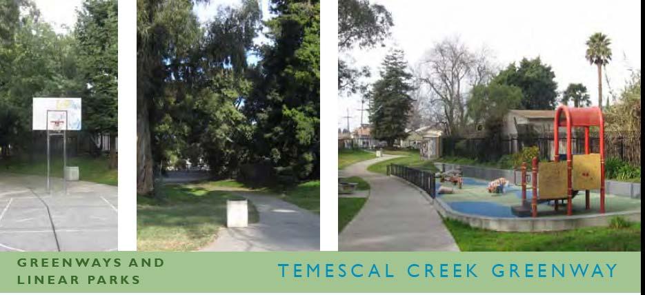
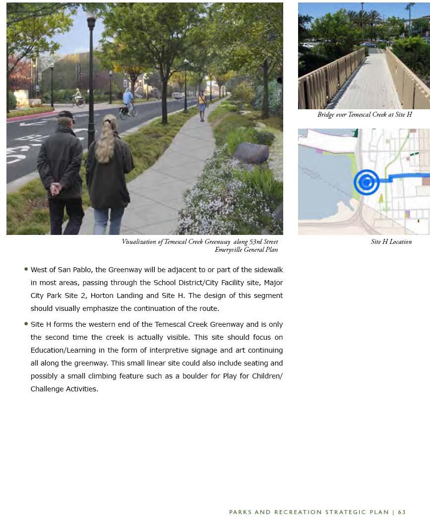
2 City Council Agenda July 19, 2011 Temescal Creek Greenway Implementation Plan Page 2 of 7 will connect North Oakland in the east to the Bay Trail and San Francisco Bay in the west. As described in the Strategic Plan, the Temescal Creek Greenway will include Temescal Creek Park, the continuation of the underground creek between 48th Street and 53 rd Street to San Pablo Avenue, on-street connections to Horton Landing Park, and connections to the mouth of Temescal Creek. The description of the Temescal Creek Greenway from the Strategic Plan is presented as Attachment 1. SGC staff advised staff to pursue the Urban Greening Grant as a plan rather than a project given the preliminary nature of the concept to date and highlight the following: the multiple benefits of the plan, the regional nature of the Greenway s proposed use and coordination and collaboration with numerous relevant agencies and stakeholders. The SGC advisors particularly highlighted the tribal significance of the prior creek route, opportunities to integrate interpretive materials and treatments sensitive to the Ohlone heritage, and the regional value of the route in connecting Oakland and Berkeley to Treasure Island. This is the second of three rounds of funding. Staff was encouraged to apply next year if an application was not feasible this year. Due to the July 1 st deadline for the grant application, staff has already submitted the grant. If the City Council does not approve the grant application, staff will withdraw the submittal. DISCUSSION/ANALYSIS The Temescal Creek Greenway Implementation Plan will assess how this critical open space and transportation network can: Provide pedestrian and bicycle access to local and regional users including school children and their families and regional commuters from Berkeley and Oakland seeking to access Treasure Island or Bay Street; Serve pre-school through high-school users who have a critical need for additional naturalized park spaces. With three school sites directly adjacent to the planned route, including the Emeryville Center for Community Life (ECCL) site, Escuela Bilengua and the Child Development Center, the Greenway could offer not only recreation but key curriculum opportunities to students via access to daylighted creek elements, riparian plantings and interpretive elements; Serve seniors (with the City s only senior facility three blocks east);
3 City Council Agenda July 19, 2011 Temescal Creek Greenway Implementation Plan Page 3 of 7 Promote tribal interests (with historic hunting and burial grounds all along the route of the now undergrounded creek);and Serve Eastshore State Park users south of Powell Avenue. The Plan will analyze the feasibility of and barriers to: Limited daylighting of creeklet segments, consideration of pipe outlets for recreated seasonal creeks varying from steady stream to or frog creeks in which seasonal water flows offer some opportunity for children to pay. Installing Creek crossings at street intersections with bioswale treatments and possible limited daylighting; Installing bicycle and pedestrian improvements to the right of way on 53 rd Street and the San Pablo Avenue offset crossing; Developing riparian improvements to existing open culverts; Constructing phased improvements at up to four publicly owned sites adjacent to the route (Emeryville Center for Community Life, Temescal Park, 48 th Street Community Garden, and Horton Street Landing Park); Developing Conditions of Approval or Design Guidelines for the development of the site owned by the Emeryville Redevelopment Agency at I-80 (including an existing open culvert and pedestrian bridge); and Upgrading improvements at the terminus of the greenway, at the mouth of the creek and the Bay, including an evaluation of Eastshore Park restrictions and opportunities. Interpretive signage and wayfinding will also be evaluated. The plan will consider improvements on the Temescal Greenway that can provide for adaptation to sea rise and risk of increased flooding. The Plan will evaluate easements and acquisition strategies for the most direct route alignment and evaluate alternative routes to implement phased development should acquisition be infeasible and use of existing right of way and public sites be necessary. Staff will work closely with other agencies and cities controlling adjacent land: the Alameda Flood Control Agency (which owns two parcels along the creek between City property at the 48 th Street Garden and Temescal Creek Park), East Bay Regional Park District/State Parks and the City of Oakland. The Plan, as proposed, is an Implementation Strategy designed to identify the physical, political, engineering, organizational, and financial limits to realizing the vision of the General Plan and address each as possible or modify the project as necessary. The Strategy will develop a project scope targeted to publically owned right of way or minimal property acquisition. The Strategy will be designed to account for security issues, flooding, and climate change. Budget estimates will be developed to evaluate capital and operating/maintenance funding feasibility.
4 City Council Agenda July 19, 2011 Temescal Creek Greenway Implementation Plan Page 4 of 7 The Workplan submitted with the grant application is presented as Attachment 2. Requirements of the Grant Plans submitted for an Urban Greening Planning Grant must receive a minimum of 65 points to be considered for funding. Points can be received for meeting program objectives, priority considerations or demonstrated organizational capacity. There are no minimum grant applications, but the maximum grant is $250,000. Proposals will be scored on the following Plan Objectives: Demonstrated need via Work Plan Identifies active involvement of community Integrates entities with jurisdiction over existing resources covered by the plan Promotes healthy community development Demonstrated organizational capacity Additional priority is given for proposals that: Are more vulnerable to climate change Serve disadvantaged or severely disadvantaged communities This grant proposal will receive priority consideration as the Triangle Neighborhood of Emeryville is defined as a qualifying disadvantaged community and Emeryville is a community of additional risk due to sea rise. A letter of concurrence was obtained from ABAG documenting the regional significance of the Plan. Letters of support were obtained from the City of Oakland, the East Bay Bicycle Coalition, the Emeryville Unified School District and Merritt College Environmental Management and Technology Program. Preliminary Scope of Work Project administration and contracting Project administration and contracting will not be charged to the grant but rather stated as an in-kind contribution including: Project Initiation / Kick-off Meeting Establish Inter-Agency Participation Process Preparation of a Request for Proposal (RFP) for consultant selection Evaluation of a Proposals and Award of consultant contract
5 City Council Agenda July 19, 2011 Temescal Creek Greenway Implementation Plan Page 5 of 7 Public outreach to Identify Existing Challenges and Opportunities Public outreach will include: Meetings with Public Agency staff including City of Oakland, Eastshore State Park, Alameda County Flood Control, Emeryville Unified School District, AC Transit Park, Cycling, Education Stakeholders and City Advisory Bodies Property Stakeholders Tribal Stakeholders These stakeholder focus groups will allow the Consultant to refine the scope of services and identify barriers to alternative alignments, key security, flooding and climate change concerns, to identify opportunities for partnership and collaboration. Conceptual Design The conceptual design will consist of evaluating three basic alternatives for the Greenway scope: 1. A greenway limited to existing right of way, city parks, and City/Agency owned property. No creek daylighting would be included in this alternative. 2. A greenway with limited creek daylighting provided through constructed creek elements on a portion of the public right of way and public property. 3. A maximized restoration or re-creation of the prior creek including targeted acquisition of property to allow continuous alignment. Budget The grant application proposes that the City bear the in-kind costs of initiating collaboration with stakeholders, selecting a consultant through an RFP process, and ongoing project management. These in-kind costs are presented as a match to the grant (about 20%, at just under $50,000) and, while not required, will give the grant application a competitive advantage. The estimated project budget is as follows: Public Outreach and Identification of Existing Challenges and Opportunities - $68,000 Conceptual Design - $ 52,000 Feasibility Analysis - $36,000 Final Temescal Greenway Implementation Plan and Feasibility Analysis - $16,000
6 City Council Agenda July 19, 2011 Temescal Creek Greenway Implementation Plan Page 6 of 7 Contingency - $20,000 Printing and graphics - $8,000 The total grant request is $200,000, with in-kind support provided by City staff in the form of project management and interagency collaboration, estimated at $47,520. Next Steps The Grant Application was submitted July 1. Preliminary meetings over the summer and fall of 2011, in advance of a grant award, may be initiated with affected agencies (such as property holders including Alameda County Flood District and East Bay Regional Parks, easement holders including East Bay Municipal Utility District, and regulators including the Bay Conservation and Development Commission to refine the scope of the request for proposals (RFP). Notification of an award is not expected until the end of the year or early spring If awarded, staff would convene initial stakeholders to a project scoping meeting in spring, and by summer of 2012, a RFP to consultants would be released. It is anticipated that the Implementation Plan would be completed by mid-year FINANCIAL CONSIDERATIONS A request of $200,000 is proposed to fund the scope of the study. No match is required by this grant source but an in-kind match is highlighted in the budget proposal and priority is given to proposals which leverage funds. LEGAL CONSIDERATIONS The City Attorney has reviewed and approved the resolution as to form.
7 City Council Agenda July 19, 2011 Temescal Creek Greenway Implementation Plan Page 7 of 7 Amber Evans, CED Coordinator Economic Development & Housing Department Helen Bean, Director Economic Development & Housing Department APPROVED AND FORWARDED TO THE CITY COUNCIL of THE CITY OF EMERYVILLE Patrick D. O Keeffe, City Manager Attachments: Resolution Attachment 1 - Description of Temescal Creek Greenway Attachment 2 Work Plan of Application to Strategic Growth Council
8 RESOLUTION NO. RESOLUTION OF THE CITY COUNCIL OF THE CITY OF EMERYVILLE APPROVING THE APPLICATION FOR THE URBAN GREENING PLANNING GRANT FOR $200,000 FOR THE TEMESCAL CREEK GREENWAY IMPLEMENTATION PLAN UNDER THE SAFE DRINKING WATER, WATER QUALITY AND SUPPLY, FLOOD CONTROL, RIVER AND COASTAL PROTECTION BOND ACT OF 2006 (PROPOSITION 84) WHEREAS, the Legislature and Governor of the State of California have provided funds for the Sustainable Communities Planning Grant and Incentives Program under the Safe Drinking Water, Water Quality And Supply, Flood Control, River And Coastal Protection Bond Act Of 2006 (Proposition 84); and WHEREAS, the Strategic Growth Council has been delegated the responsibility for the administration of this grant program, establishing necessary procedures; and WHEREAS, said procedures by Strategic Growth Council require a resolution certifying the approval of application(s) by the Applicants governing board before submission or provide a draft resolution and commitment to approve such a resolution at the next board meeting in such cases as the board is meeting after the submittal deadline; and WHEREAS, the applicant, if selected, will enter into an agreement with the State of California to carry out the development of the Urban Greening Plan; NOW, THEREFORE, BE IT RESOLVED that the CITY COUNCIL OF THE CITY OF EMERYVILLE hereby: 1. Approves the filing of an application for the Temescal Creek Greenway Implementation Plan, and 2. Certifies that applicant understand the assurances and certification in the application; and 3. Certifies that Applicant will have sufficient funds to develop the Plan or will secure the resources to do so, and 4. Certifies that applicant will work towards the State s Planning Priorities intended to promote equity, strengthen the economy, protect the environment and promote public health and safety as identified in Government Code Section , and 5. Appoints the City Manager, or designee, as agent to conduct all negotiations, execute and submit all documents, including, but not limited to applications, agreements, and payment requests, and so on, which may be necessary for the completion of the aforementioned project(s).
9 Resolution City Council Agenda July 19, 2011 Temescal Creek Greenway Implementation Plan Page 2 of 2 ADOPTED by the City Council of the City of Emeryville at its regular meeting held Tuesday, July 19, 2011 by the following vote: AYES: NOES: EXCUSED: ABSTAINED: ABSENT: MAYOR ATTEST: APPROVED AS TO FORM: CITY CLERK CITY ATTORNEY

10
11
12
13 Attachment 2 Urban Greening Planning Grant Application: Temescal Creek Greenway Implementation Plan Work Plan The Temescal Creek Greenway Implementation Plan is split into two phases. The first phase, without support from the grant, will be provided by the City of Emeryville as an in kind match and will include: Project Initiation / Kick off Meeting Establish Inter Agency Participation Process Development of an RFP for consultant selection (state review of this scope of work will be arranged as necessary) Award of consultant contract This phase will determine the alternatives to be considered in the contracted scope including key alternative routes, key acquisition sites to be evaluated and the scope of a financing strategy related to these acquisitions and project development. There are three alternatives to the planned route, to be explored and potentially included in the scope of work, these are: a. Basic Greenway plant trees and plant palette consistent with Bayfriendly palette, create interpretive signage and bicycle and pedestrian amenities from Adeline Street through Temescal Creek Park to 53 rd Street to Horton Landing Park and the South Bayfront Bridge to Ohlone way and the pedestrian bridge over the culvert at the mouth of the creek at the San Francisco Bay. b. Creek Crossings and Greenway Consider a variety of options for creek interpretation, bioswale development, and possible release of seasonal flow from the existing storm drain into proposed bioswale(s) installed in curb extensions along 53 rd Street. c. Limited Daylighting of the Creek and Greenway Consider a variety of options for daylighting, re creation of creek beds, creek interpretation, release of seasonal flow from the existing storm pipes and other water features in the park and greenway segments along the proposed greenway route including: Temescal Creek Park 48 th Street Community Garden Alameda County Flood District lands Emeryville Unified School District property A major park acquisition site at the existing PGE facility Novartis parking facilities Horton Landing Park 1
14 CDC property at the culvert at the mouth of the creek The second phase will be initiated with a consulting contract funded by the proposed grant for the development of a Temescal Creek Greenway Implementation Plan and include the following elements: Public Outreach Identify Existing Challenges and Opportunities Public Agency Staff Meeting Park and Cycling Stakeholder Focus Group Property Stakeholder Focus Group City Advisory Body Focus Groups Education, Senior and Disabled Service Provider Focus Group Tribal Stakeholder Focus Group Survey of utilities Research of as built utilities/sonar detection for right of way constraint analysis Develop Community Meeting #1 Materials Website Development & Support Community Workshop #1 Conceptual Design Evaluate existing right of way and daylighting and greenway potential Evaluate existing public property and daylighting and greenway potential Conceptual Design Alternatives daylighting and stormwater diversion Draft plant palette Inventory Trees and compatibility with stormwater modifications Community Workshop #2 Feasibility Analysis Easement acquisition strategy Fee title acquisition strategy Public project phasing and project modification Draft Conditions of Approval for adjacent properties Capital and operating cost projections Funding options Safety and public access analysis Community Workshop #3 Final Temescal Greenway Implementation Plan and Feasibility Analysis Draft Final Implementation Plan and Feasibility Analysis City Council and Planning Commission Meetings (5) Final Report Temescal Creek Greenway Implementation Plan will assess how a critical open space and transportation network can serve: 2
15 Local and regional pedestrian and bicycle access (including school children and their families served by facilities along the greenway and regional commuters from Berkeley and Oakland seeking to access Treasure Island or Bay Street Center); Pre school through high school users who have a critical need for additional naturalized park spaces. With three school sites directly adjacent to the planned route, including the Emeryville Center for Community Life (ECCL) site, Escuela Bilengua and the Child Development Center, the Greenway could offer not only recreation but key curriculum opportunities to students via access to daylighted creek elements, riparian plantings and interpretive elements; Seniors (with City s only senior facility three blocks east); Tribal interests (with historic hunting and burial grounds all along the route of the now undergrounded creek); Eastshore State Park users; and Adjacent public and private property owners with limited exposed creek segments in culverts through out the Greenway possible routing. The Plan will analyze the feasibility of and barriers to: Limited daylighting of creeklet segments, consideration of pipe outlets for recreated seasonal creeks varying from steady stream to padding or frog creeks and exploration of creek crossings at street intersections (with bioswale treatments and possible limited daylighting); Bicycle and pedestrian improvements to the right of way on 53 rd Street and the San Pablo Avenue offset crossing; Riparian improvements to existing open culverts; Phased improvements at up to four publicly owned sites adjacent to the route (ECCL, Temescal Park, 48 th Street Community Garden, Horton Street Landing Park); Conditions of approval or design guidelines for the development site owned by the Emeryville Redevelopment Agency at I 80 (including an existing open culvert and pedestrian bridge); Consideration of site acquisition or easements where park, access or daylighting could be expanded via a feasible acquisition from a willing seller; and The mouth of the creek, bay interface, Eastshore State Park restrictions and opportunities, storm water system outlet, and the terminus of the greenway plan. Interpretive signage and wayfinding will also be evaluated. The plan will consider improvements on the Temescal Creek Greenway that can provide for adaptation to sea rise and risk of increased flooding. The Plan will evaluate easements and acquisition strategies for the most direct route alignment and evaluate alternative routes to 3
16 implement phased development should acquisition be infeasible and use of existing right of way and public sites be necessary. Staff will work closely with other agencies and cities controlling adjacent land: the Alameda Flood Control Agency (which owns two parcels along the creek between City property at the 48 th Street Garden and San Pablo Avenue), East Bay Regional Park District/State Parks and the City of Oakland. Plan as proposed is an Implementation Strategy designed to identify the physical, political, engineering, organizational, and financial limits to realizing the vision of the General Plan and then address them. The Strategy will develop a project scope targeted to publically owned right of way or minimal property acquisition. The Strategy will be designed to account for security issues, flooding, and climate change. Budget estimates will be developed to evaluate capital and operating/maintenance funding feasibility. 4
CITY OF LARKSPUR Staff Report. August 21, 2013 Council Meeting UPDATE ON TRANSPORTATION AUTHORITY OF MARIN (TAM) GREENBRAE CORRIDOR WORKING GROUP
 GREENBRAE CORRIDOR WORKING GROUP") AGENDA ITEM 7.1 CITY OF LARKSPUR Staff Report August 21, 2013 Council Meeting DATE: August 16, 2013 TO: FROM: SUBJECT: Honorable Mayor Hillmer and Members of the City Council Dan Schwarz, City Manager
AGENDA ITEM 7.1 CITY OF LARKSPUR Staff Report August 21, 2013 Council Meeting DATE: August 16, 2013 TO: FROM: SUBJECT: Honorable Mayor Hillmer and Members of the City Council Dan Schwarz, City Manager
Honorable Mayor and Members of the City Council. Submitted by: Eric Angstadt, Director, Planning and Development
 Office of the City Manager ACTION CALENDAR January 29, 2013 To: From: Honorable Mayor and Members of the City Council Christine Daniel, City Manager Submitted by: Eric Angstadt, Director, Planning and
ADOPTION OF THE REVISED OPEN SPACE AND CONSERVATION ELEMENT OF THE GENERAL PLAN
 TO: FROM: SUBJECT: Honorable Mayor and City Council Planning Department ADOPTION OF THE REVISED OPEN SPACE AND CONSERVATION ELEMENT OF THE GENERAL PLAN RECOMMENDATION: It is recommended that the City Council:
DRAFT PLAN PRESENTATION
 DRAFT PLAN PRESENTATION 1.23.2018 AGENDA Process Project Schedule Results from Visioning Workshop Draft Plan Highlights Concept Plans Feedback Next Steps PROJECT SCHEDULE KICK-OFF WORKSHOP August 29 th
Submitted by: Phillip L. Harrington, Director, Department of Public Works. Framework for Green Infrastructure Plan Development
 Page 1 of 8 Office of the City Manager CONSENT CALENDAR June 13, 2017 To: From: Honorable Mayor and Members of the City Council Dee Williams-Ridley, City Manager Submitted by: Phillip L. Harrington, Director,
Berkeley Strategic Transportation Plan
 Berkeley Strategic Transportation Plan 48 4. Priming the Pipeline 4. Priming the Project Pipeline Building on our history Using past studies that required the effort and input of all of Berkeley s distinct
CITY OF CHARLOTTESVILLE, VIRGINIA CITY COUNCIL AGENDA
 CITY OF CHARLOTTESVILLE, VIRGINIA CITY COUNCIL AGENDA Agenda Date: December 16, 2013 Action Required: Adoption of Resolution Presenter: Staff Contacts: Title: James E. Tolbert, AICP, Director of NDS James
Support the implementation of Cape Coral's Comprehensive Plan. Protect and utilize the unique natural resources in the City.
 7.0 OVERVIEW - RECOMMENDATIONS Chapter 7 The preparation of the Cape Coral Parks and Recreation Master Plan spanned a period of approximately 12 months. Plan preparation included the input of a wide range
RESOLUTION NO. R Refining the route, profile and stations for the Downtown Redmond Link Extension
 RESOLUTION NO. R2018-32 Refining the route, profile and stations for the Downtown Redmond Link Extension MEETING: DATE: TYPE OF ACTION: STAFF CONTACT: Capital Committee Board PROPOSED ACTION 09/13/2018
CONSENT CALENDAR September 27, 2005
 Office of the Executive Officer September 27, 2005 To: From: Submitted By: Subject: Honorable Chairperson and Members of the Redevelopment Agency Phil Kamlarz, Executive Officer Dan Marks, Director, Planning
AGENDA ITEM: IOWA. west] that were not FISCAL IMPACT. the City of Clive. STAFF REVIEW. Resolution II. Amendment PREPARED BY: REVIEWED BY:
![AGENDA ITEM: IOWA. west] that were not FISCAL IMPACT. the City of Clive. STAFF REVIEW. Resolution II. Amendment PREPARED BY: REVIEWED BY:](/thumbs/93/112428810.jpg "AGENDA ITEM: IOWA. west] that were not FISCAL IMPACT. the City of Clive. STAFF REVIEW. Resolution II. Amendment PREPARED BY: REVIEWED BY:") AGENDA ITEM: CITY OF WAUKEE, IOWA CITY COUNCIL MEETING COMMUNICATION MEETING DATE: March 7, 2016 AGENDA ITEM: Consideration of approval of a resolution approving Engineering Services Amendment No. 1 with
AGENDA ITEM: CITY OF WAUKEE, IOWA CITY COUNCIL MEETING COMMUNICATION MEETING DATE: March 7, 2016 AGENDA ITEM: Consideration of approval of a resolution approving Engineering Services Amendment No. 1 with
Summary of Action Strategies
 Strategic Action Plan 6 Summary of Action Strategies Action Strategy Categories: 1. Organization and Management 2. Implementation 3. Marketing and Promotion This chapter summarizes all of the action strategies
Council Agenda Report
 Agenda Item #5.4. Council Agenda Report SUBJECT: BRIDGE TO BEACH MULTI-USE PATHWAY PROJECT SIGNAGE, KIOSKS AND MAP DESIGN APPROVAL MEETING DATE: JUNE 21, 2012 RECOMMENDATION Staff recommends that the City
Urban Greening Plan Proposed Policies and Programs Matrix Existing City Plans and Goals Programs Policies Notes/Comments
 Urban Greening Plan Circulation Plan for Bicyclists and Pedestrians (2007) 1.1 - Develop a coordinated Trail Maintenance Volunteer Program that identifies funding and leverages community efforts and partnerships
COASTAL CONSERVANCY. Staff Recommendation March 25, 2004 LOS ANGELES GREEN VISION PLAN. File No.: Project Manager: Marc Beyeler
 COASTAL CONSERVANCY Staff Recommendation March 25, 2004 File No.: 04-014 Project Manager: Marc Beyeler RECOMMENDED ACTION: Authorization to disburse up to $50,000 to the University of Southern California
3. VISION AND GOALS. Vision Statement. Goals, Objectives and Policies
 Vision Statement Queen Creek s interconnected network of parks, trails, open spaces and recreation opportunities provide safe and diverse activities and programs that sustain its unique, small town, equestrian
Streets for People, Place-Making and Prosperity. #TOcompletestreets
 COMPLETE STREETS FOR TORONTO Streets for People, Place-Making and Prosperity COMPLETE STREETS: A NEW APPROACH A Complete Streets design approach considers the needs of all users people who walk, bicycle,
Philip A. Ginsburg, General Manager Dawn Kamalanathan, Director, Planning and Capital Projects
 Date August 5, 2015 To: Through: From: Subject: Recreation and Park Commission Capital Committee Philip A. Ginsburg, General Manager Dawn Kamalanathan, Director, Planning and Capital Projects Nicole Avril,
The transportation system in a community is an
 7 TRANSPORTATION The transportation system in a community is an important factor contributing to the quality of life of the residents. Without a sound transportation system to bring both goods and patrons
STAFF REPORT TO THE CITY COUNCIL. Conduct Public Hearing to vacate certain public right of way adjacent to Sycamore Avenue and San Pablo Avenue
 STAFF REPORT TO THE CITY COUNCIL DATE: Adjourned Regular Meeting of December 16, 2014 TO: SUBMITTED BY: SUBJECT: Mayor and Members of the City Council Holly Smyth, Planning Director Conduct Public Hearing
Provide and maintain sufficient public parks, recreation facilities, and open space to meet the recreational needs of County residents and visitors.
 (ROS) Goal Provide and maintain sufficient public parks, recreation facilities, and open space to meet the recreational needs of County residents and visitors. OBJECTIVE ROS.01 The County shall acquire,
RECREATION AND OPEN SPACE ELEMENT GOALS, OBJECTIVES, AND POLICIES
 RECREATION AND OPEN SPACE ELEMENT GOALS, OBJECTIVES, AND POLICIES Goal 7 To provide park facilities, recreation programs, and open space resources that are safe, adequate, and accessible to all City residents,
Presentation Item C Annotated Model Outline for a Framework for a Green Infrastructure Plan
 Date: August 17, 2016 To: From: Subject: Management Committee Dan Cloak, Consultant Presentation Item C Annotated Model Outline for a Framework for a Green Infrastructure Plan Recommendation: Receive the
India Basin/Hunters Point Shoreline Community Workshop May 21, 2008
 India Basin/Hunters Point Shoreline Community Workshop May 21, 2008 Workshop Agenda Welcome Process Overview Context & Existing Conditions Presentation of Draft Concepts Land Use and Open Space Priorities
COASTAL CONSERVANCY. Staff Recommendation June 5, 2008 SAN DIEGO RIVER TRIBUTARY CANYONS PROJECT. File No Project Manager: Megan Johnson
 COASTAL CONSERVANCY Staff Recommendation June 5, 2008 SAN DIEGO RIVER TRIBUTARY CANYONS PROJECT File No. 08-059 Project Manager: Megan Johnson RECOMMENDED ACTION: Authorization to disburse an amount not
REPORT TO MAYOR AND COUNCIL
 AGENDA ITEM NO..e REPORT TO MAYOR AND COUNCIL TO THE HONORABLE MAYOR AND COUNCIL: DATE: March 1, 1 SUBJECT: ADOPTING RESOLUTION NOS. 1-, 1-, 1-, and 1- ORDERING THE PREPARATION OF THE ENGINEER S REPORT
FOUR MILE RUN VALLEY WORKING GROUP AND CHARGE Adopted April 16, 2016 Amended July 19, 2016
 FOUR MILE RUN VALLEY WORKING GROUP AND CHARGE Adopted April 16, 2016 Amended July 19, 2016 Working Group Charge The Working Group is charged by the County Board to collaborate with staff to provide commission,
CHARLES COUNTY GOVERNMENT RFP NO POPES CREEK RAIL TRAIL DESIGN
 CHARLES COUNTY GOVERNMENT Department of Fiscal and Administrative Services Purchasing Division Telephone: 301-645-0656 July 7, 2015 RFP NO. 16-02 POPES CREEK RAIL TRAIL DESIGN ADDENDUM NUMBER ONE TO: All
CITY OF VAUGHAN EXTRACT FROM COUNCIL MEETING MINUTES OF NOVEMBER 15, 2016
 Item 11, Report No. 38, of the Committee of the Whole, which was adopted without amendment by the Council of the City of Vaughan on November 15, 2016. Regional Councillor Di Biase declared an interest
FOUR MILE RUN VALLEY WORKING GROUP AND CHARGE
 FOUR MILE RUN VALLEY WORKING GROUP AND CHARGE Adopted April 16, 2016 Amended July 19, 2016 Overview of Integrated Effort The overall goal of the Four Mile Run Valley (4MRV) initiative is to develop a comprehensive
WOONASQUATUCKET RIVER WATERSHED COUNCIL REQUEST FOR PROPOSALS DESIGN OF GREENWAY PALETTE, SIGNAGE AND AMENITIES
 WOONASQUATUCKET RIVER WATERSHED COUNCIL REQUEST FOR PROPOSALS DESIGN OF GREENWAY PALETTE, SIGNAGE AND AMENITIES PROJECT BACKGROUND The Woonasquatucket River Watershed Council (WRWC) is a 501(c)3 organization
Comprehensive Plan ADOPTED APRIL 2014
 Comprehensive Plan ADOPTED APRIL 2014 8 8. Outstanding Recreational & Cultural Opportunities We are proud of our community s parks and recreation system. Our community will ensure that the legacy of our
This page intentionally blank.
 This page intentionally blank. Parks, Recreation, and Open Space Chapter Relationship to Vision Vision Parks, Recreation and Open Space Chapter Concepts County Government. County government that is accountable
Development Solicitation Request for Qualifications. The Historic Hollering Place Development
 City of Coos Bay Urban Renewal Agency Development Solicitation Request for Qualifications The Historic Hollering Place Development For More Information Contact: Eric Day Community Development Director
A BLUEPRINT FOR BROCKTON A CITY-WIDE COMPREHENSIVE PLAN
 A BLUEPRINT FOR BROCKTON A CITY-WIDE COMPREHENSIVE PLAN Public Meeting October 2016 1 Plan Summary and Discussion Public Meeting May 4 2017 City of Brockton Bill Carpenter, Mayor Department of Planning
SAN RAFAEL GENERAL PLAN 2040 INTRODUCTION AND OVERVIEW
 SAN RAFAEL GENERAL PLAN 2040 INTRODUCTION AND OVERVIEW Steering Committee Presentation February 14, 2018 Purpose of General Plan Guide land use and development decisions Coordinate transportation, infrastructure,
METROPOLITAN COUNCIL 390 North Robert Street, St. Paul, MN Phone (651) ; TDD (651)
 ; TDD (651)") DATE: December 20, 2011 METROPOLITAN COUNCIL 390 North Robert Street, St. Paul, MN 55101 Phone (651) 602-1000; TDD (651) 291-0904 TO: Metropolitan Parks and Open Space Commission FROM: Tori Dupre, Senior
DATE: December 20, 2011 METROPOLITAN COUNCIL 390 North Robert Street, St. Paul, MN 55101 Phone (651) 602-1000; TDD (651) 291-0904 TO: Metropolitan Parks and Open Space Commission FROM: Tori Dupre, Senior
REPORT TO MAYOR AND COUNCIL
 REPORT TO MAYOR AND COUNCIL AGENDA ITEM NO. 5.a TO THE HONORABLE MAYOR AND COUNCIL: DATE: May 26, 2015 SUBJECT: ADOPT RESOLUTION NOS. 15-33, 15-34, 15-35, AND 15-36, CONFIRMING THE ASSESSMENT DIAGRAMS
Public Open House. Overview of the Downtown Plan Official Plan Amendment April 23, 2018
 Public Open House Overview of the Downtown Plan Official Plan Amendment April 23, 2018 1 A 25-Year Plan for Downtown To ensure growth contributes positively to Toronto s Downtown as a great place to live,
CITY OF VACAVILLE PLANNING COMMISSION Agenda Item No. G. 1 STAFF REPORT August 4, Staff Contact: Tricia Shortridge (707)
") CITY OF VACAVILLE PLANNING COMMISSION Agenda Item No. G. 1 STAFF REPORT August 4, 2009 Staff Contact: Tricia Shortridge (707) 449-5140 TITLE: REQUEST: LONGS / CVS DRIVE-THRU PHARMACY & REMODEL TIME EXTENSION
CITY OF VACAVILLE PLANNING COMMISSION Agenda Item No. G. 1 STAFF REPORT August 4, 2009 Staff Contact: Tricia Shortridge (707) 449-5140 TITLE: REQUEST: LONGS / CVS DRIVE-THRU PHARMACY & REMODEL TIME EXTENSION
Potential Green Infrastructure Strategies May 6, 2015 Workshop
 Potential Green Infrastructure Strategies May 6, 2015 Workshop Background The City of Cortland is developing the Tioughnioga Urban Headwaters Green Infrastructure Action Plan with funding from the National
A larger version of this map is located on the last page of this PDF.
 MAP Committee Input McLoughlin Area Draft Vision Map A larger version of this map is located on the last page of this PDF. 1. The map above is intended to portray a vision for the McLoughlin area. It highlights
Planning Commission Report
 Planning Commission Report To: From: Subject: Planning Commission Meeting: January 6, 2016 Agenda Item: 8-B Planning Commission David Martin, Planning & Community Development Director Introduction to the
Report Date: June 25, 2013 Contact: Nick Kassam Contact No.: RTS No.: VanRIMS No.: Meeting Date: July 10, 2013
 ADMINISTRATIVE REPORT Report Date: June 25, 2013 Contact: Nick Kassam Contact No.: 604.829.2097 RTS No.: 10051 VanRIMS No.: 08-2000-20 Meeting Date: July 10, 2013 TO: FROM: SUBJECT: Standing Committee
At first Work Session on October 22, At second Work Session on November 19, At third Work Session on December 3, 2015
 At first Work Session on October 22, 2015 Staff Reviewed Infrastructure: Transportation Capacity School Capacity Willett Branch Proposed Staging Language At second Work Session on November 19, 2015 Land
Mississippi Skyway Preliminary Engineering Report
 EXECUTIVE SUMMARY Mississippi Skyway Preliminary Engineering Report CITY OF RAMSEY, MINNESOTA DECEMBER 2014 City of RAMSEY EXECUTIVE SUMMARY Project Need and Intent The Mississippi Skyway pedestrian bridge
Silverdale Regional Center
 Silverdale Regional Center Vision for Silverdale Regional Center The Silverdale Regional Center Plan (Plan) will guide the evolution of the Silverdale Regional Center from a collection of strip malls and
Call for Artists for: Design and Construction of Environmental Art Activation Story Mill Community Park, Bozeman, MT
 Call for Artists for: Design and Construction of Environmental Art Activation Story Mill Community Park, Bozeman, MT Seeking artists to design, fabricate and install art elements in the nature sanctuary
G. RECREATION AND OPEN SPACE ELEMENT. The following summarizes the Recreation and Open Space Element:
 G. RECREATION AND OPEN SPACE ELEMENT The purpose of the Element is to provide the framework and direction for a comprehensive system of public and private sites for recreation, including, but not limited
Beautification Advisory Committee Mission Statement and Goals & Objectives
 Beautification Advisory Committee Mission Statement and Goals & Objectives 2011-2012 MISSION STATEMENT To advise the Marco Island City Council on beautifying the community s landscape in a way consistent
The City shall enhance and improve the accessibility of parks and recreational facilities while protecting their quality. by:
 GOALS, OBJECTIVES AND POLICIES GOAL 1: To provide open space and recreation as an essential element needed for the betterment of the City s character and quality of urban life. The City shall plan for
RECREATION, OPEN SPACE AND GREENWAYS ELEMENT GOALS, OBJECTIVES, AND POLICIES
 RECREATION, OPEN SPACE AND GREENWAYS ELEMENT GOALS, OBJECTIVES, AND POLICIES GOAL R-1: DEVELOP A RECREATION, OPEN SPACE AND GREENWAYS SYSTEM AS AN INTEGRAL COMPONENT OF AN OVERALL, COUNTY-WIDE ECONOMIC
DATE: January 19, WCA Governing Board. Johnathan Perisho, Project Manager. Mark Stanley, Executive Officer
 DATE: January 19, 2016 TO: FROM: THROUGH: SUBJECT: WCA Governing Board Johnathan Perisho, Project Manager Mark Stanley, Executive Officer Item 18: Consideration of a resolution to approve contract amendment
Yadkin River Greenway Feasibility Study Fact Sheet Village of Clemmons, Town of Lewisville, Town of Bermuda Run
 Fact Sheet Village of Clemmons, Town of Lewisville, Town of Bermuda Run Project Background The Yadkin River Greenway Feasibility Study is a joint project with the Village of Clemmons, the Town of Bermuda
The Five Components of the McLoughlin Area Plan
 The Five Components of the McLoughlin Area Plan This documents contains the complete language of the five components of the McLoughlin Area Plan: The Vision Statement The Values The Guiding Principles
Transportation Committee
 Transportation Committee Business Item No. 2013-286SW Meeting date: October 14, 2013 For the Metropolitan Council meeting of October 16, 2013 Subject: Southwest Light Rail Transit (Green Line Extension):
IMPACT ON FINANCIAL AND PERSONNEL RESOURCES:
 MEMORANDUM TO: FROM: CITY COUNCIL GEOFF ENGLISH, PUBLIC WORKS DIRECTOR SUBJECT: CONSIDERATION OF ADOPTION OF RESOLUTIONS ORDERING THE PREPARATION AND FILING OF ANNUAL ENGINEER S REPORTS FOR THE PARKSIDE
Support for Walnut Creek Watershed Council. Adopt resolution of support for the newly formed Walnut Creek Watershed Council.
 CITY OF MARTINEZ CITY COUNCIL AGENDA March 6, 2013 TO: FROM: SUBJECT: DATE: Mayor and City Council Tim Tucker, City Engineer Support for Walnut Creek Watershed Council March 1, 2013 RECOMMENDATION: Adopt
Update on the Bayfront Canal Bypass Project. Recommendation This an informational item only. No City Council action is required at this time.
 AGENDA ITEM H-7 continued from 4/18 Public Works STAFF REPORT City Council Meeting Date: 4/18/2017 Staff Report Number: 17-081-CC Informational Item: Update on the Bayfront Canal Bypass Project Recommendation
CHAPTER 8 ISSUES, CONCERNS, CONSTRAINTS AND OPPORTUNITIES
 CHAPTER 8 ISSUES, CONCERNS, CONSTRAINTS AND OPPORTUNITIES Introduction This River Conservation Plan was developed during a time of tremendous activity and effort in planning the transformation of the Delaware
AGENDA # Copy Mailed to Alderperson
 City of Madison, Wisconsin AGENDA # Copy Mailed to Alderperson SUBSTITUTE RESOLUTION Adopting Approving the Growing a Stronger Community with Community Gardens: An Action Plan for Madison and the Committee
Preliminary Plan Framework: Vision and Goals
 Preliminary Plan Framework: Vision and Goals Draft: May 2015 Introduction Since the Town of Milliken s comprehensive plan was last updated in 2010, the community was heavily impacted by the 2013 flood,
Town Center (part of the Comprehensive Plan)
") Town Center (part of the Comprehensive Plan) Mercer Island Town Center Looking North (2014) In 1994, a year-long process culminated in a set of design guidelines and code requirements for the Town Center
Town Center (part of the Comprehensive Plan) Mercer Island Town Center Looking North (2014) In 1994, a year-long process culminated in a set of design guidelines and code requirements for the Town Center
SUBJECT: Waterfront Hotel Planning Study Update TO: Planning and Development Committee FROM: Department of City Building. Recommendation: Purpose:
 Page 1 of Report PB-23-18 SUBJECT: Waterfront Hotel Planning Study Update TO: Planning and Development Committee FROM: Department of City Building Report Number: PB-23-18 Wards Affected: 2 File Numbers:
City of Mahtomedi Park System Plan Public Hearing Draft: September 13, 2006
 Chapter 6: IMPLEMENTATION INTRODUCTION Earlier chapters of this Plan analyzed existing conditions, identified park and recreation needs, and proposed park, trail, and open space recommendations. This chapter
Pedestrian and Bike Bridge LOGO
 6.2.2 Pedestrian and Bike Bridge The proposed pedestrian and bike crossing re-envisions the existing bridge at Pismo Creek on Cypress Street. The bridge is currently underutilized by vehicular through
~!VAUGHAN NOV Z November 21, Mr. Denis Kelly, Regional Clerk The Regional Municipality of York Yonge Street Newmarket, ON L3Y 6Z1
 ~!VAUGHAN NOV Z 5 2016 November 21, 2016 Mr. Denis Kelly, Regional Clerk The Regional Municipality of York 17250 Yonge Street Newmarket, ON L3Y 6Z1 Dear Mr. Kelly: RE: NEW KIRBY GO STATION IN BLOCK 27
Visioning Committee Kick-Off Meeting
 Visioning Committee Kick-Off Meeting June 11, 2018 The Team Project management, technical analysis, implementation, report preparation Public engagement, park review Recreation facilities review, operations
AGENDA ITEM # 13A/B. AGENDA ITEM EXECUTIVE SUMMARY Village Board Meeting December 10, 2018
 AGENDA ITEM # 13A/B AGENDA ITEM EXECUTIVE SUMMARY Village Board Meeting December 10, 2018 Item Title: Main Street Parking Improvements Parking Lot Project Change Order #2 and Final Pay Request Staff Contact:
CITY OF BEACON NOTICE TO LANDSCAPE ARCHITECTS GENERAL INFORMATION AND REQUEST FOR PROPOSALS
 CITY OF BEACON NOTICE TO LANDSCAPE ARCHITECTS GENERAL INFORMATION AND REQUEST FOR PROPOSALS The City of Beacon (the CITY) is issuing this Request for Proposals (RFP) for the selection of a landscape architect
MEETING DATE: November 12, 2013 SUBJECT: Accept Borden Road Bridge Improvement (CIP No )
") AGENDA REPORT Meeting of the San Marcos City Council MEETING DATE: November 12, 2013 SUBJECT: Accept Borden Road Bridge Improvement (CIP No. 88165) Recommendation Staff recommends the City Council adopt
AGENDA REPORT Meeting of the San Marcos City Council MEETING DATE: November 12, 2013 SUBJECT: Accept Borden Road Bridge Improvement (CIP No. 88165) Recommendation Staff recommends the City Council adopt
Arlington, Virginia is a worldclass
 EXECUTIVE S U M M A RY Arlington maintains a rich variety of stable neighborhoods, quality schools and enlightened land use policies, and received the Environmental Protection Agency s highest award for
Durango Parks & Recreation Department. Strategic Plan
 Durango Parks & Recreation Department Strategic 2019-2023 Adopted April 2019 Overview The purpose of the adopted 2010 Parks, Open Space, Trails and Recreation Master is to provide a 10-year road map for
PROJECT BACKGROUND. Preliminary Design Scope and Tasks
 PROJECT BACKGROUND Preliminary Design Scope and Tasks The purpose of this Study is the development of preliminary designs for intersection improvements for Trunk Highway (TH) 36 at the intersections of
Corridor Vision. 1Pursue Minnehaha-Hiawatha Community Works Project. Mission of Hennepin County Community Works Program
 1Pursue Minnehaha-Hiawatha Community Works Project Minnehaha-Hiawatha Community Works is a project within the Hennepin Community Works (HCW) program. The mission of the HCW program is to enhance how the
SOUTH AFRICA S PREPARATIONS FOR HABITAT III COMMON AFRICAN POSITION FOR HABITAT III. Habitat III Urban Breakfast 5 October 2016
 SOUTH AFRICA S PREPARATIONS FOR HABITAT III COMMON AFRICAN POSITION FOR HABITAT III Habitat III Urban Breakfast 5 October 2016 Context and Background 1. Africa intends actively shaping the New Urban Agenda,
TOWN OF WHITBY REPORT RECOMMENDATION REPORT
 TOWN OF WHITBY REPORT RECOMMENDATION REPORT REPORT TO: Council REPORT NO: PL 95-09 DATE OF MEETING: October 13, 2009 PREPARED BY: Planning/Public Works Joint Report FILE NO(S): N/A LOCATION: N/A REPORT
Rio de Janeiro - Brazil. Urban Regeneration & Climate Change
 Rio de Janeiro - Brazil Urban Regeneration & Climate Change 2017 Rio de Janeiro - Brazil introduction slide 1 BRASIL 204.5 million inhabitants RIO DE JANEIRO STATE 16.5 million inhabitants RIO DE JANEIRO
Chapter 1: Introduction
 Chapter 1: Introduction The Penn Avenue Community Works Corridor Vision and Implementation Framework presents an integrated communitybased vision and a coordinated, long-term implementation framework for
SPECIFIC PLAN Requirements
 CITY OF LANCASTER PLANNING DEPARTMENT 44933 Fern Avenue, Lancaster, California 93534 (661) 723-6100 SPECIFIC PLAN Requirements Purpose The purpose of a specific plan is to provide for the logical development
Portage County Parks, Trails and Greenways Plan
 Portage County Parks, Trails and Greenways Plan Agenda for Local Planning Meeting Introductory Presentation Why we need a Plan Plan project goals and process Benefits Overview of local planning region
RFP REQUEST FOR PROPOSALS CITY OF PORTSMOUTH, NH. DESIGN ENGINEERING SERVICES North Mill Pond Trail and Greenway
 RFP 61-18 REQUEST FOR PROPOSALS CITY OF PORTSMOUTH, NH DESIGN ENGINEERING SERVICES North Mill Pond Trail and Greenway Sealed Requests for Proposals, plainly marked RFP 61-18 Design Engineering Services
Historic Preservation Element
 Casa Gardens by Carolyn Pelkey Historic Preservation Element Incorporated in 1928, the City of San Clemente was among the first master planned communities in the U.S. built from open grazing land. Before
S A C R A M E N T O C O U N T Y JACKSON HIGHWAY & GRANT LINE EAST VISIONING STUDY
 JACKSON HIGHWAY & GRANT LINE EAST S A C R A M E N T O C O U N T Y P L A N N I N G D E P A R T M E N T SUMMARY AND WORKBOOK November 19, 2008 History of the Visioning Study Sacramento County has two growth
MAIN STREET ECONOMIC DEVELOPMENT STRATEGY
 MAIN STREET ECONOMIC DEVELOPMENT STRATEGY A PATHWAY TO A BETTER POUGHKEEPSIE DRAFT Working Paper #2: Planning Strategies Submitted December 1 st, 2015 to the City of Poughkeepsie LAND USE LAW CENTER PACE
implementation r expression in landscape
 6 ubc okanagan implementation campus plan r expression in landscape 68 6 implementation campus plan sections The Campus Plan supports the academic mission, values and commitments of the University by providing
PUBLIC SERVICES ELEMENT GOALS / POLICIES / MEASURES
 PUBLIC SERVICES ELEMENT GOALS / POLICIES GOALS / POLICIES / MEASURES Authority The Public Services Element addresses provision of municipal services to City residents. The following paragraphs provide
City Council Special Meeting AGENDA ITEM NO. C.
 City Council Special Meeting AGENDA ITEM NO. C. DATE: 01/04/2019 TO: Honorable Mayor and City Council Members SUBJECT: Transit Villages Specific Plan project Study Session (Development Services Director
10 Implementation. Implementation. Responsibility for Implementation. Blueprint for Bloomsburg. Town of Bloomsburg Comprehensive Plan 10-1
 Implementation 10 Implementation This chapter overviews how to use the comprehensive plan as a land use and programming tool for the Town of Bloomsburg and recommends annual review of the plan by the Town
8implementation. strategies
 PROGRAM STRATEGIES 8implementation strategies T he implementation actions of this chapter are designed to support and carry out the land use, economic development, transportation, urban design, and program
Get Connected: Balancing Built and Natural Environments for Sustainability
 Get Connected: Balancing Built and Natural Environments for Sustainability The Mid-South Regional Greenprint and Sustainability Plan seeks to connect a network of green space across Shelby County TN, Fayette
SAN RAFAEL CITY COUNCIL AGENDA REPORT
 Agenda Item No: 7.b Meeting Date: December 4, 2017 SAN RAFAEL CITY COUNCIL AGENDA REPORT Department: Public Works/City Attorney Prepared by: Kevin McGowan, Asst. Director of Public Works Lisa Goldfien,
DRAFT Subject to modifications
 TREASURE COAST REGIONAL PLANNING COUNCIL DRAFT M E M O R A N D U M To: Council Members AGENDA ITEM 7C From: Date: Subject: Staff September 17, 2010 Council Meeting Commuter Rail Update Resolution of Support
San Diego River Coalition 2012 Work Plan
 San Diego River Coalition 2012 Work Plan Adopted November 18, 2011 The mission of the San Diego River Coalition is preserve and enhance the San Diego River, its watershed, and its natural, cultural and
ALLEN CREEK GREENWAY. Citizens Advisory Committee Meeting #5 July 19, Allen Creek Greenway Master Plan. July 2017
 1 ALLEN CREEK GREENWAY MASTER PLAN Citizens Advisory Committee Meeting #5 July 19, 2017 Agenda 2 Final DRAFT Preferred Plan (30 min) Master Plan Document Outline (5 min) Potential Implementation Strategy
PARTF Scoring System for Grants
 PARTF Scoring System for Grants The members of the N.C. Parks and Recreation Authority use the PARTF scoring system as one of several tools to select grant recipients. Please provide all of the information
Re: Alameda Point Update Review and Comment on SunCal s September 19, 2008 Development Concept
 Alameda Reuse and Redevelopment Authority Memorandum ITEM 10-A To: From: Honorable Chair and Members of the Alameda Reuse and Redevelopment Authority Debra Kurita Executive Director Date: November 5, 2008
Parks Master Plan Implementation: Phase I Waterfront Use and Design REPORT #: September 7, 2016 File #
 0 'O DI Lan-171-14 1 - THE CORPORATION OF THE TOWN OF COBOURG..,. STAFF REPORT TO: FROM: Mayor and Members of Council Dean A. Hustwick, Director of Recreation and Culture DATE OF MEETING: Committee of
MISSISSIPPI GORGE REGIONAL PARK MASTER PLAN
 MISSISSIPPI GORGE REGIONAL PARK MASTER PLAN Minneapolis Park and Recreation Board CAC MEETING #1 APRIL 23, 2018 AGENDA Mississippi Gorge Regional Park Master Plan CAC #1 01 / Welcome and Calling Circle
HILLSBOROUGH COUNTY Greenways and Trails Plan Update. Executive Summary. Date
 HILLSBOROUGH COUNTY Greenways and Trails Plan Update Executive Summary Date PURPOSE AND PROJECT OVERVIEW The Hillsborough County Greenways Master Plan (1995) and the City of Tampa s Greenways and Trails