PREPARED BY: City of Omak
|
|
|
- Justin Evans
- 5 years ago
- Views:
Transcription
1 GREATER OMAK AREA COMPREHENSIVE PLAN PREPARED BY: City of Omak ASSISTED BY: Highlands Associates MAPS PREPARED BY: Highlands Associates IN COOPERATION WITH: Confederated Tribes of the Colville Reservation, Okanogan County and City of Okanogan
2 REVISIONS TO THE 1993 GREATER OMAK AREA COMPREHENSIVE PLAN MAP REVISIONS: Resolution June 30, 1995 Amend land use designation: a) Orchards commercial Center from Residential Low Density to Mixed Use; b) Shellrock Point Partnership from Residential Low Density to Mixed Use; c) North Omak Properties Parcel A from Residential Low Density to Mixed Use Ordinance 1408 June 2, 1999 Sunrise Investments Amend land use designation from Residential Low Density to Mixed Use Resolution February 22, 2000 Turnbull property Amend land use designation from Residential Low Density to Mixed Use Resolution May 1, 2000 Wenatchee Valley College-North Amend land use designation from Residential High Density to Public Use Resolution March 10, 2004 Amendments to the Land Use and Transportation Element maps Resolution July 2005 Amendments to include Community Facilities map TEXT AMENDMENTS: Resolution March 10, 2004 Amendments to the Land Use and Transportation Elements (A & B) and maps. Resolution July 2005 Amendments to update the Public Utilities, Economic Development, Cultural Preservation, Community Facilities, and Citizen Participation Elements (C, D, E, F, and G) and corresponding maps
3 This document represents an update of the November 1993 plan that was dedicated to the memory of Carl Lyons. Carl served on the City s Planning Commission for over 20 years and worked tirelessly for the good of the people of Omak. The Plan is intended to guide land use and development decisions within the City of Omak and provide Okanogan County and the Confederated Tribes of the Colville Indian Reservation a clear idea on the City s long range plans and community vision City Council of Omak Dale Sparber, Mayor Michael Foth Leanne Leifer Cindy Gagne City Clerk Trish Butler Public Works Director Fred Sheldon Steve Clark Clinton Watts Donna Short Deputy Clerk Kathy Lobdell City Attorney Michael D. Howe Building Inspector/Permit Administrator Craig Raymond City Planning Commission Del Shove, Chairman Mary Henrie Marie Fry Esther Rabchuk Jane Lynch Jack Brauer Sandy Thomas Consulting Planner Highlands Associates
4 TABLE OF CONTENTS PART I: FOUNDATION...1 DESCRIPTION OF PLANNING AREA... 1 PURPOSE... 1 AUTHORITY TO PREPARE AND IMPLEMENT PLAN... 3 PUBLIC INVOLVEMENT IN PLAN DEVELOPMENT... 3 GOALS... 4 EVOLVING NATURE OF COMPREHENSIVE PLAN... 9 ELEMENTS OF THE GREATER OMAK AREA COMPREHENSIVE PLAN PART II: PLAN ELEMENTS... A-11 PLAN ELEMENT A: LAND USE...A-11 Population......A-12 Existing Land Uses...A-20 General Land Use Goals and Policies...A HOUSING & RESIDENTIAL DEVELOPMENT...A-24 Policies for Housing and Residential Development...A-24 Comprehensive Plan for Housing and Residential Development...A COMMERCIAL DEVELOPMENT...A-28 Policies for Commercial Development...A-28 Comprehensive Plan for Commercial Development...A INDUSTRIAL DEVELOPMENT...A-31 Policies for Industrial Development...A-32 Comprehensive Plan for Industrial Development in the Greater Omak Area...A PUBLIC USES...A-34 Policies for Public Uses...A RESOURCE LANDS, CRITICAL AREAS AND SHORELINES...A-35 Policies for Resource Lands, Critical Areas and Shorelines...A OPEN SPACE...A-55 Policies for Open Space...A GROWTH AND FRINGE AREAS AND ANNEXATION...A-57 Policies for Growth and Fringe Areas and Annexation...A IMPLEMENTATION...A-59 Policies for Implementation...A-59 Methods of Implementation...A-59
5 9. RECOMMENDATIONS FOR THE LAND USE ELEMENT...A-64 General......A-64 Residential Development......A-64 Commercial Development......A-64 Industrial Development......A-66 Public Uses......A-66 Resource Lands, Critical Areas and Shorelines......A-66 Open Space......A-66 Urban Growth and Fringe Areas and Annexation......A-67 Implementation......A-67 PLAN ELEMENT B: TRANSPORTATION/CIRCULATION... B-69 Goals, Policies, and Objectives for Transportation/Circulation in the Greater Omak Area... B PUBLIC TRANSPORTATION... B-77 Surface Transit... B-77 Senior Citizens... B-77 Tribal Van Pool... B AIR TRANSPORT... B VEHICULAR CIRCULATION... B PEDESTRIAN/NON-MOTORIZED CIRCULATION... B RECOMMENDATIONS FOR TRANSPORTATION/CIRCULATION... B-91 Vehicular Transportation... B-91 Pedestrian/Non-Motorized Circulation... B-92 PLAN ELEMENT C: PUBLIC UTILITIES...C-94 Policies for Public Utilities Element... C WATER SYSTEM... C-96 Recommended Summary of Capital Works for Water in the Greater Omak Area. C-99 Prioritized Improvements... C WASTE WATER TREATMENT SYSTEM... C-100 Recommended Summary of Capital Works for Waste Water Treatment in the Greater Omak Area... C STORM DRAINAGE... C PUBLIC UTITLIES AND ANNEXATION POLICY... C SOLID WASTE... C-102
6 6. IMPLEMENTATION OF PUBLIC UTILITIES ELEMENT CAPITAL FACILITIES PLANNING... C RECOMMENDATIONS FOR THE PUBLIC UTILITIES ELEMENT... C-104 PLAN ELEMENT D: ECONOMIC DEVELOPMENT...D BACKGROUND...D-106 The Vision Statement...D-107 Policies for Economic Development...D-108 Comprehensive Plan for Economic Development...D-110 Implementation...D RECOMMENDATIONS FOR THE ECONOMIC DEVELOPMENT ELEMENT...D-110 PLAN ELEMENT E: CULTURAL PRESERVATION... E BACKGROUND... E-113 Indian Culture... E-113 Anglo Culture... E-113 Hispanic Culture... E-113 Policies for the Cultural Element... E RECOMMENDATIONS... E-115 PLAN ELEMENT F: COMMUNITY FACILITIES... F BACKGROUND...F-116 Policies for Community Facilities...F-116 Public Parks and Recreation Facilities...F-117 City of Omak Park Plan...F117 Okanogan County Outdoor Recreation Plan...F119 Community Facilities/Services...F RECOMMENDATIONS FOR COMMUNITY FACILITIES...F-124 PLAN ELEMENT G: CITIZEN PARTICIPATION...G BACKGROUND...G-126 Policies for Citizen Participation...G RECOMMENDATIONS...G-127
7 APPENDIX OF MAPS MAP I PLANNING AREA MAP II CITY CORE AREA CURRENT LAND USE MAP III URBAN GROWTH AREA CURRENT LAND USE MAP IV LAND USE DESIGNATIONS CITY CORE AREA MAP V LAND USE DESIGNATION CITY AND URBAN GROWTH AREA MAP VI SOILS MAP CITY CORE AREA MAP VII SOILS MAP CITY AND URBAN GROWTH AREA MAP VIII WETLANDS MAP CITY CORE AREA MAP IX WETLANDS MAP CITY AND URBAN GROWTH AREA MAP X PRIORITY HABITAT AND SPECIES MAP CITY CORE AREA MAP XI PRIORITY HABITAT AND SPECIES MAP CITY/URBAN GROWTH AREA MAP XII STEEP SLOPES MAP CITY CORE AREA MAP XIII STEEP SLOPES MAP CITY/URBAN GROWTH AREA MAP XIV FLOOD HAZARD MAP CITY CORE AREA MAP XV FLOOD HAZARD MAP CITY AND URBAN GROWTH AREA MAP XVI FUNCTIONAL CLASSIFICATION MAP CITY CORE AREA MAP XVII FUNCTIONAL CLASSIFICATION MAP CITY/URBAN GROWTH AREA MAP XVIII PROPOSED ROADS MAP CITY CORE AREA MAP XIX PROPOSED ROADS MAP CITY AND URBAN GROWTH AREA MAP XX EXISTING PEDESTRIAN & NON-MOTORIZED CIRCULATION MAP (CITY) MAP XXI EXISTING PEDESTRIAN & NON-MOTORIZED CIRCULATION MAP (UGA) MAP XXII PROPOSED PEDESTRIAN & NON-MOTORIZED CIRCULATION MAP (CITY) MAP XXIII PROPOSED PEDESTRIAN & NON-MOTORIZED CIRCULATION MAP (UGA)
8 COMPREHENSIVE PLAN UPDATE PART I: FOUNDATION DESCRIPTION OF PLANNING AREA The planning area covered by this plan encompasses the present corporate limits and the Urban Growth Area 1, an area of approximately 4,000 acres along both sides of the Okanogan River with the City of Omak occupying the south central portion of the area. The Omak Airport, while outside of the Planning Area described above, is also considered in this plan 2. Map I depicts the planning area. PURPOSE It has been a decade since the original Greater Omak Comprehensive Plan was prepared. That landmark effort, the first cooperative planning venture between an incorporated community, Okanogan County and the Confederated Tribes of the Colville Reservation, provided the framework and guidelines needed to maintain a healthy environment, create a sustainable economic base and protect the quality of life by cooperatively: Managing the resources of the physical and social environment comprising the planning area; Planning for new development and change within the City and in its surrounding area; Providing a mechanism for intergovernmental review, development and correlation of regulations, controls, programs and services; Reviewing the coordination of planning and administration by all agencies of the city, tribal, county and adjacent city governments, utilities, private organizations and individual property owners, as well as all residents involved in the development of the planning area. Maintaining the integrity of existing commercial, residential and industrial areas. Providing a plan to manage change in a manner acceptable to the majority of area residents Providing a means for the community to control its own destiny The purpose for planning remains the same today as in The outlined purpose provides a basis for the goals, objectives and policies that form the heart of the Plan. The purposes are expressed directly or by implication in the text and planning maps and together these constitute the Greater Omak Area Comprehensive Plan. 1 -the UGA was confirmed by the City Council on DATE, please refer to the Omak Airport Business and Industry Park Conceptual Master Plan, October 16,2000, for detailed plans for this important area. 1 Part I - Foundation
9 COMPREHENSIVE PLAN UPDATE This update is intended to further the cooperative planning effort used to prepare the 1993 plan. It is of paramount concern that the Tribes and County agree to adopt and utilize the plan to guide actions affecting land uses within the planning area. 2 Part I - Foundation
10 COMPREHENSIVE PLAN UPDATE AUTHORITY TO PREPARE AND IMPLEMENT PLAN This Plan is a legally recognized document that provides the framework for making land use and other planning decisions. It is adopted under the authority of RCW This Act provides authority for decisions and procedures to follow that guide and regulate physical development. Although adopted by ordinance, it is a policy document; the primary regulatory tools the City has to implement the policies are the Zoning and Subdivision Ordinances. PUBLIC INVOLVEMENT IN PLAN DEVELOPMENT The Planning Commission, City staff and consulting planner, prepared this update to the 1993 plan. The Commission worked on the update at their regular monthly meetings beginning in 2001 and continued throughout Public involvement in the development of the 1993 comprehensive plan was crucial in making the document an accurate reflection of the community's needs and desires. Throughout the planning process, citizen input has been sought in the form of public workshops and meetings, appearances on a local radio program, presentations to various civic, educational and business organizations and through informal contact with community members. The public involvement process revealed one main overriding theme for why people live, work and play in the Greater Omak Area - the rural, small town lifestyle. Characteristics of this theme include: quietness, traditional values, rural atmosphere, open and friendly community, low crime rate, cultural diversity, clean environment and lack of traffic problems. Another important outcome of the public involvement process was the identification of major improvements that would make life in the Omak area better. The most common input was a desire for more economic development, particularly industrial and a wider variety of commercial activities, and a growing concern about traffic congestion, specifically in the commercial areas of the community. The need for industrial development was also supported. Industrial development, especially light, environmentally sound businesses was a very common answer. The result of the public involvement efforts is the expression of the needs, desires and dreams of area citizens. Community input during the update process reflected a continued desire to maintain the direction established in In conclusion, public sentiment clearly favors a balance between growth (all types) and maintenance of the rural quality of life. 3 Part I - Foundation
11 COMPREHENSIVE PLAN UPDATE GOALS The essence of the Comprehensive Plan lies in the goals, objectives for the plan in general and policies for specific plan elements. The outcome of the public involvement process played an important role in the formation of overall goals and objectives for the Comprehensive Plan. Policies, which arise from the general goals and objectives, are included in each plan element. These specific policies are intended to guide decisions regarding land use activities. Goals, Objectives and Policies are defined as follows: Goals are defined as "ends to be aimed at", or "desires" or "ambitions" Objectives are defined as "specific purposes to achieve broad goals." Policies are defined as "prudent courses of action chosen to attain specific objectives." In the following text these concepts will be used as points of reference from which the overall Comprehensive Plan and its individual elements will be developed. The goals and objectives for the development of the Greater Omak Area follow: 4 Part I - Foundation
12 COMPREHENSIVE PLAN UPDATE GOAL To protect and promote the health, safety, efficiency, economy, convenience, aesthetics and general welfare of the Greater Omak Area by guiding development while preserving the environment and managing resources through the planning process Objectives Create a positive climate for change and community involvement in all levels of decision making Develop a community where young persons are actively encouraged to participate in community development efforts Encourage all types of cultural, recreational and education opportunities and events as a means of stimulating responsible community involvement Encourage the design and development of a community which promotes a healthy and safe environment Create a positive atmosphere for sustainable and diverse economic activity Actively promote the development and redevelopment of the Central Business District as a vital link in preserving Omak as a self reliant community Create linkages that promote cooperative efforts between: business; city, county and tribal governments; citizens; civic organizations; and, environmental interests Recognize cultural diversity as a positive force in the community 5 Part I - Foundation
13 COMPREHENSIVE PLAN UPDATE GOAL To protect and preserve the rural quality of life enjoyed by area residents Objectives Maintain ready physical access to open spaces in the community as well as to publicly owned lands in the surrounding area Ensure visual access to open spaces within and surrounding the community Ensure that development along the Okanogan River provides for pedestrian access but does not substantially detract from the natural character of the shoreline Protect agricultural lands of long term economic significance from urbanization Maintain street and transportation systems that are uncongested and safe for motorized and non-motorized travel Maintain the small town atmosphere and the relatively crime free environment Ensure that growth and development do not significantly degrade the environmental quality (air, water, rural landscape, etc...) of the area Ensure that growth and development are limited as much as possible to the valley floor and benchlands to reduce or eliminate disturbance of the hillsides, bluffs and other "critical" areas 6 Part I - Foundation
14 COMPREHENSIVE PLAN UPDATE GOAL To provide for controlled growth within limits established by the resources and services the City, County and Tribes can efficiently and effectively develop and maintain Objectives Establish and plan for an urban growth area based on the City, County and/or Tribes ability to provide and maintain services Coordinate and cooperatively plan for the provision of services needed for urban type development Coordinate and cooperatively manage development to ensure growth does not significantly degrade environmental quality Ensure that growth and development does not exceed the limits of the City's ability to provide for transportation/circulation, parks and recreation, public safety, public utilities and education 7 Part I - Foundation
15 COMPREHENSIVE PLAN UPDATE GOAL To ensure that land uses and development within the Colville Indian Reservation are driven by and sensitive to the cultural and economic needs of the Native American community Objectives Recognize and respect the sovereignty of the Confederated Tribes of the Colville Reservation Work with the Tribal Government for guidance and recommendations when considering land use actions that directly or potentially affect portions of the planning area lying within the exterior boundaries of the Colville Indian Reservation Foster cooperative planning and regulation among the City, Tribes, County, State and public and private utilities for land use, utility development, economic growth and environmental protection Strive to understand the needs and desires of reservation residents when considering land use actions Respect cultural differences and their various manifestations in land use and development Recognize and encourage efforts to mitigate the separation of East Omak resulting from construction of Highway 97 8 Part I - Foundation
16 COMPREHENSIVE PLAN UPDATE GOAL To provide policy direction to appointed and elected officials charged with making recommendations and decisions regarding development and infrastructure improvements Objectives Involve affected neighbors in the decision making process Consider planning, regulatory and project impacts on neighborhoods Encourage citizens to take responsibility for their community Review and update this plan at least once every five years Refer to this plan whenever recommendations or decisions are made that may impact any of the elements addressed herein These goals extend across all aspects of community life, and involve preservation of those things that are good as well as the willingness to provide for orderly change through private and public participation. EVOLVING NATURE OF COMPREHENSIVE PLAN A comprehensive plan is never final as the community described in the plan is ever changing and the goals, dreams and desires of community members change to reflect current conditions. Therefore it should be understood that the City Planning Commission should initiate a public review of the plan at a minimum of every five years to ensure that the plan meets the changing needs of the community. This 2005 update is the second significant review to take place since the original plan was adopted in Part I - Foundation
17 COMPREHENSIVE PLAN UPDATE ELEMENTS OF THE GREATER OMAK AREA COMPREHENSIVE PLAN Elements selected for review and objective consideration in this update of the plan are as follows: C. PUBLIC UTILITIES 1. Water System 2. Wastewater Treatment System 3. Storm Drainage 4. Public Utilities and Annexation Policy 5. Solid Waste D. ECONOMIC DEVELOPMENT 1. Background 2. Recommendations E. CULTURAL PRESERVATION 1. Background 2. Recommendations F. COMMUNITY FACILITIES 1. Background 2. Recommendations G. CITIZEN PARTICIPATION 1. Background 2. Recommendation 10 Part I - Foundation
18 COMPREHENSIVE PLAN UPDATE PART II: PLAN ELEMENTS PLAN ELEMENT A: LAND USE How the land is used and the resulting impacts on the social, economic, cultural and environmental fabric of a community make up the primary reasons, beyond regulatory mandates, for preparing a comprehensive land use plan. Community desires for a rural lifestyle, clean air and water, uncongested streets (a transportation system, vehicular and non-vehicular, based on land uses rather than land uses determined by transportation systems), affordable housing, economic opportunity and open spaces and recreation now and in the future are all dependent on how the land is used. The Land Use Element of the Comprehensive Plan is an important tool for promoting orderly community growth over time. Land Use planning takes existing residential, commercial, industrial, public and other uses into account and balances those existing uses with environmental, economic and human factors. It incorporates requirements under the Growth Management and Shoreline Management Acts to designate and protect lands that are environmentally significant. The Land Use Element is intended to be a Plan that guides everyday land use decisions, as well as future development. For the Element to succeed in its purpose, the analysis, goals, and policies it sets forth must interact closely with zoning, subdivision, shorelines, critical areas, and other land use regulations. The plan should provide a structure that the public, landowners, and government entities can look to in maintaining the City of Omak as a desirable place to live, do business, work, and recreate. As such, the Land Use Element is a guide for the preservation and development of the community's public and private property within the established general pattern and desired future of the community. The Land Use Element of this plan is intended to provide direction for managing change in the following areas: Housing and Residential Development; Commercial Development; Industrial Development; Public Uses; Resource Lands, Critical Areas and Shorelines; Open Space; Urban Growth Areas and Annexation; and, Implementation. This element provides the foundation from which the remaining elements (e.g. transportation/circulation, public utilities, etc...) are built. All other plan elements must be driven by the land use element, which by virtue of its central role, must be based on the broadest consensus possible in terms of the community's vision and desires. The update of this plan element is keyed on an inventory of existing land uses, environmental constraints, public input and cooperative review by affected agencies, governments and utilities. The Land Use Element covers lands within the corporate limits of the City of Omak, as well as those lands within the adopted Urban Growth Boundary (see the Planning Area Map). A-11 Part II Land Use Element
19 COMPREHENSIVE PLAN UPDATE POPULATION Information on the resident population of Omak is an important part of the picture of land use within the community. Changes in the population affect the demand for housing, infrastructure, and services to a community, which in turn influences the pattern of development. For that reason, some basic information about the population of Omak is included in this Element. This section first examines population trends and develops 5, 10, 15, and 20-year population projections for the City and Urban Growth Area (UGA). It then offers buildout projections for the City and UGA. The following tables and figures show historical population data for the City of Omak. This data provides a starting point for projecting population changes. Table II.1 details changes in the City s population by decade from 1910 to Figure II.1 illustrates the growth in numbers of residents from 1980 to Table II.1 - Historical City of Omak Population Trends Year Population % Change , % , % , % , % , % , % , % , % , % A-12 Part II Land Use Element
20 COMPREHENSIVE PLAN UPDATE Figure II.1 Population Trend Popul ation Year As the data shows, growth during the 1990s far outpaced that of the 1980s. Over the decade growth averaged 1.2% per year, for a total of 14.7% (or 601 people) between 1991 and POPULATION PROJECTIONS For planning purposes, four population projections have been prepared for the City and the UGA. The first, referred to as slow growth, assumes an annual population growth of.5%, which would continue the trend established during the late 1980's and early 1990's. The second, referred to as moderate growth, assumes an annual population growth of 1% that is closest to the average of 1.2% per year through the 1990s. The third, referred to as fast growth, assumes an annual rate of 2% that reflects annual electrical load increases experienced by the Public Utility District during the mid-1990s. The fourth, referred to as very rapid growth, assumes an annual rate of 3% that recognizes the Omak area's movement into an era of supporting new development. The large number of annexations over the past decade have resulted in new residential and commercial development, resolution of the City's water supply and storage problems and recently completed upgrades to the sewer treatment system. These changes help make the case for assuming the City will continue to see the higher growth rates experienced in the mid and late 1990's. For example, in that decade, the City brought in the Wildwood residential development with the understanding it would see an eventual build out of 453 dwelling units. This growth alone, spread over 20 years at the current average household size ( ), would be nearly equivalent to 1% per year growth. Combined with other growth, the City clearly has potential to grow at a rate in excess of 1% in the coming decades. It must be noted, however, that all Census figure A-13 Part II Land Use Element
21 COMPREHENSIVE PLAN UPDATE population projections are speculative and should be regularly adjusted in the light of actual population figures. Table II.2 presents population projections for the City based on the.5%, 1%, 2% and 3% annual growth figures. Table II.2 - City Population Projections Slow Growth - 0.5% 4,721 4,840 4,962 5,088 5,216 increase from Moderate Growth 1% 4,721 4,962 5,215 5,481 5,761 increase from Fast Growth - 2% 4,721 5,212 5,755 6,354 7,015 increase from ,034 1,633 2,294 Very Rapid Growth - 3% 4,721 5,473 6,345 7,355 8,527 increase from ,624 2,634 3,806 The other population projection that affects land use as well as capital planning is the potential increase of persons residing in the unincorporated portion of City's Urban Growth Area (UGA). Current population of the UGA outside the City limits is estimated at 831, based on data from the Okanogan County Assessors office on land uses in the area and average household size (2.46). Using this number and the same growth rates used to project City population growth, the following table shows projections for the unincorporated portions of the UGA: A-14 Part II Land Use Element
22 COMPREHENSIVE PLAN UPDATE Table II.3 - Unincorporated UGA Population Projections Slow Growth 0.5% increase from Moderate Growth - 1% ,014 increase from Fast Growth 2% ,013 1,118 1,235 increase from Very Rapid Growth - 3% ,117 1,295 1,501 increase from Table II.4 presents an overall population projection for the entire UGA (both incorporated and unincorporated areas). Table II.4 - Urban Growth Area Population Projections Slow Growth 0.5% 5,552 5,692 5,836 5,983 6,134 increase from Moderate Growth - 1% 5,552 5,835 6,133 6,446 6,774 increase from ,222 Fast Growth 2% 5,552 6,130 6,768 7,472 8,250 increase from ,216 1,920 2,698 Very Rapid Growth - 3% 5,552 6,436 7,461 8,650 10,028 increase from ,909 3,098 4,476 A-15 Part II Land Use Element
23 COMPREHENSIVE PLAN UPDATE OTHER POPULATION DATA The projections agree relatively well with other available population and growth data. Between 1990 and 2000, Okanogan County s population increased approximately 19%, from 33,350 to 39,564. That increase equates to around 1.7% per year, as compared with the City s growth of 1.2% per year. The discrepancy shows that growth has been slightly higher in unincorporated areas. While somewhat out of date the 1995 document, A Housing Needs Assessment and Strategies for Okanogan County, indicates growth trends in excess of 2%. In the past decade, Eastern Washington saw growth rates of 2.3% per year, while in the State as a whole non-metropolitan areas grew at a rate of 2.5% per year. This population growth is reported to be primarily the result of migration to rural areas, a trend occurring throughout the nation. 4 Past population projections have used information on electrical demand from Okanogan County PUD to help complete the picture of growth. As this update is being prepared, however, several factors, including shifts in the economy, power rates, conservation efforts, and a new substation serving the area, render that data much less useful for substantiating current growth rates. Omak School District enrollments have also been used in the past to substantiate population trends. However, the District has seen significant decreases each year since Table II.5 below illustrates the changes through the 1990's. School district figures may not match overall population growth for three reasons. First, the boundaries of the District are much larger than those of the City. Second, census figures show that the largest component of the current population has been in the age group. Third, there has been a continuing trend, both nationwide and regionally, to smaller family sizes. 4 - A Housing Needs Assessment & Strategies for Okanogan County, Tom Phillips & Associates with Raj Joshi. March, A-16 Part II Land Use Element
24 COMPREHENSIVE PLAN UPDATE Table II.5 - School District Enrollment Data Year Total Enrollment % Change from Previous Year ,816-6% , % , % ,028-2% , % , % ,125 +1% , % , % , % , % ,997 BUILDOUT PROJECTIONS Buildout projections are a calculation of the maximum population growth that can be expected in the City's Urban Growth area (both incorporated and unincorporated), based on reasonable assumptions about infill of vacant lots, annexations, and density of development. Maximum growth is important to consider when the City designates land for future land uses, designs streets, sewer lines, water lines, parks, etc. It is generally much less expensive to install an oversized water or sewer line which will meet the 10-year or 20-year demand than to install a line to meet current needs which must eventually be replaced as demand increases. This buildout projection is based largely upon the analysis contained in the City of Omak Residential Land Use Analysis, completed in November of 1998 by Highlands Associates. The study looked at the ability of lands within the existing incorporated limits to accommodate projected growth. Undeveloped parcels were identified in each zoning district. Based upon zoning and landscape characteristics, each parcel was assigned a potential buildout in dwelling units. In summary the study found that the 1998 City Limits were sufficient to accommodate A-17 Part II Land Use Element
25 COMPREHENSIVE PLAN UPDATE growth by 4,027 people, assuming an average family size of 2.46 persons and 1,637 new residential units. Table II.6 below shows the calculation of parcels for each zoning district. Table II.6 - Buildout by Zoning District Zone Residential development potential Population potential at 2.46 persons per household RS RD RM 476 1,171 CB 0 0 PS 0 0 HB LI PU 0 0 Total 1,637 4,027 From 1999 through the end of 2002, the City of Omak issued building permits for 9 singlefamily dwellings and a 26 unit apartment complex. In 2002, two homes were moved from outside the City Limits to new locations within the city, and a new manufactured home was also permitted. This, in theory, uses up 38 of the 1,637 dwelling units identified in the 1998 study, thus dropping the number of potential dwelling units to 1,599. The potential buildout for the City of Omak has also been altered through annexation of additional lands. The Turnbull-Walla Annexation in 1999 added 38 acres of Residential Single- Family (RS) land and 56 acres of Residential Duplex (RD). Based on the location and existing development patterns, it is assumed the 1 dwelling unit per acre for RS lands and 4 dwelling units per acre for the RD lands. All together the Turnbull-Walla Annexation is assumed to provide space for 262 dwelling units. At 2.46 people per household, this results in accommodation for 644 additional residents. Thus, potential buildout within the existing city limits would accommodate 1,861 dwelling units. This equates to 4,578 people. Based on this calculation, the City has more than enough land within the existing corporate limits to allow for very rapid growth (3%) for the next 20 years. In addition, a combination of undeveloped, open space, and agricultural lands in the Urban Growth Area yields 1,248 acres of land with development potential. If a figure of 2.5 units per acre is assigned, this results in 3,120 additional dwelling units. At 2.46 persons per household, that would mean the Urban Growth Area could accommodate 7,675 more people. The total buildout A-18 Part II Land Use Element
26 COMPREHENSIVE PLAN UPDATE calculation for the city and UGA would yield a population of 16,974. Even under the most vigorous of growth conditions, this is highly unlikely to occur within the next 20 years. (See FigureII.2 for the assumptions used to develop population and buildout projections.) Figure II.2 - Growth Assumptions 1. Average housing density will be two and one half units per acre. New development around Omak (such as Wildwood) is being planned at four units per acre, and its reasonable to assume that some new apartment units will be built. However, the area east of S.R. 97 has typically been subdivided to larger lots, as has the unincorporated area to the west of the City. The 2.5 units per acre figure is meant as an average, and should be examined and adjusted as development continues. 2. Average household size is assumed to be This figure is derived from the 2000 Census. The average household size is somewhat larger statewide, at As was noted in the 1996 Capital Facilities Plan forecast, the average household size has been falling steadily all over Eastern Washington. It seems reasonable to expect that much of the new construction in the Omak area will attract mostly older and wealthier residents, who typically have smaller household sizes. 3. In calculating the acres available, no allowance was made for land that cannot be developed due to steep slopes, wetlands, or other constraints. Such factors are rare in this particular area, thought it is possible that slope may limit a few sites. 4. The population for the Urban Growth Area was calculated based on information from the Okanogan County Assessors database. Parcels with residential uses were tallied and multiplied by 2.46, the average household size. 5. To calculate buildout in the Urban Growth Area, the acreage of all lands coded as agricultural, open space agriculture, or undeveloped was tallied. That acreage was multiplied by 2.5 which generated the total number of dwelling units. The number of dwelling units was multiplied by 2.46 to yield the potential population. A-19 Part II Land Use Element
27 COMPREHENSIVE PLAN UPDATE EXISTING LAND USES Maps II and III illustrate the current development pattern within the City and its UGA. The incorporated limits of Omak encompass approximately 1,786 acres of land. According to Okanogan County Assessor s records for land use, just over 68.58% percent of the total acreage is developed land. Of the 1,786 acres that comprise the City of Pateros, 20% of the land is developed with residential uses; 8% percent is commercial; 4% is industrial; 11% serves public or semi-public uses (schools, parks, churches, and City-owned properties); 1% is held in trust by the Colville Tribes; and 24% is made up of road right-of-ways. These figures, as well as the number of acres, parcels and percentage of developed area for each type of land use, are shown in Table II.7 below. This assessment of existing land uses, in combination with assumptions about population growth, are the basis for projecting the City s future needs. A-20 Part II Land Use Element
28 COMPREHENSIVE PLAN UPDATE Table II Land Use WITHIN CITY LIMITS WITHIN URBAN GROWTH AREA TOTAL CITY OF OMAK AND UGA % OF % OF TOTAL NUMBER % OF % OF TOTAL NUMBER % OF % OF TOTAL NUMBER DEVELOPED LAND OF DEVELOPED LAND OF DEVELOPED LAND OF LAND USE ACRES AREA AREA PARCELS ACRES AREA AREA PARCELS ACRES AREA AREA PARCELS Residential Single Family % 18.11% % 22.94% % 21.32% 450 Multi Family % 2.26% % 1.07% % 1.47% 51 Commercial % 8.38% % 1.75% % 3.96% 109 Industrial Light % 1.08% % 0.09% % 0.42% 17 Heavy % 2.81% % 0.00% % 0.94% 3 Public/Semi Public 0.00% 0.00% % 0.00% 0 City % 1.34% % 1.24% % 1.27% 41 Park & Rec % 5.80% % 0.00% % 1.94% 9 Schools % 2.39% % 0.27% % 0.98% 10 State % 0.38% % 0.52% % 0.47% 14 County % 0.26% % 0.15% % 0.19% 11 Churches % 0.55% % 0.11% % 0.26% 18 Tribe % 1.29% % 16.57% % 11.46% 80 Streets, Alley, ROW, Other % 23.94% % 3.30% % 10.21% 47 Developed Area % 68.58% % 48.02% % 33.68% 860 Agriculture Agriculture- Open Space Undeveloped % % % 325 Total Land Area A-21 Part II - Land Use Element
29 COMPREHENSIVE PLAN GENERAL LAND USE GOALS AND POLICIES The following goals and policies are intended to reinforce and support the Comprehensive Plan Goals and Policies found in Part I: LAND USE GOAL 1: Manage land use in such a way to maintain and improve Omak as a comfortable, aesthetically pleasing, healthy and safe place to live. Policy 1.1: Use Comprehensive Plan guidelines and other local ordinances to maintain a livable and safe community. LAND USE GOAL 2: Protect the rights of individual property owners without sacrificing community-wide goals. Policy 2.1 Provide an adequate public review process for all land use decisions using the media and any other resources available that will encourage participation by the public. LAND USE GOAL 3: Encourage land use practices that protect the integrity of the natural environment to ensure that the community has an adequate source of clean water and air and to otherwise maintain a healthy human environment. Policy 3.1 Ensure that all proposed land uses are analyzed for impacts to local ground water. Policy 3.2 Require that all future growth be connected to City sewer and water utilities. Policy 3.3 Utilize SEPA, the Shoreline Master Program, and Critical Areas policies and regulations to ensure protection of the natural environment and critical resources. LAND USE GOAL 4: Coordinate the varied pattern of land use with circulation routes and public facilities so as to promote convenience, efficiency, health and welfare of the city. Policy 4.1 Ensure that the review of all development proposals includes traffic and transportation considerations. Policy 4.2 Enhance pedestrian access in and around the community in order to reduce the unnecessary use of automobile transportation that contributes to degradation of air quality and waste of non-renewable resources. LAND USE GOAL 5: Protect and help develop, whenever possible, desirable public and private investments in land and improvements. Policy 5.1 Foster partnerships among agencies, organizations, and businesses to encourage and entice new development. A-22 Part II - Land Use Element
30 COMPREHENSIVE PLAN LAND USE GOAL 6: Encourage planned growth in and around Omak that is sensitive to the preservation of the area's agricultural economy. Policy 6.1 Encourage agricultural development beyond the Urban Growth Boundary. Policy 6.2 Encourage development of businesses or industries that utilize locally produced crops. LAND USE GOAL 7: Ensure that the costs of development do not create an unfair economic burden for the taxpayers of the community. Policy 7.1 Require developers to pay proportional costs for upgrades of existing infrastructure needed to adequately serve new development. A-23 Part II - Land Use Element
31 COMPREHENSIVE PLAN 1. HOUSING & RESIDENTIAL DEVELOPMENT Shelter is a primary need and providing safe, adequate and affordable housing is becoming an acute problem in the Greater Omak Area. While the availability of land and good transportation links are assets to the supply of available building sites and housing, the cost and availability of city services, various state and local requirements and other costs, make development of new affordable housing a serious problem. Policies for Housing and Residential Development The following policies are intended to guide decision-making regarding housing and residential development in the Greater Omak Area. The City, County and Tribes shall: Policy 1: encourage and support the provision of a variety of healthy, safe housing units within the economic reach of all residents. Policy 2: encourage provision of areas for new low and medium density single-family housing as well as the infrastructure needed to serve these areas. Policy 3: each develop and require standards for where factory, modular and manufactured homes (both designated and non-designated) may be placed on individual lots. Policy 4: provide for medium and high density multi-family residential areas near commercial zones. Policy 5: designate an Urban Growth Area that protects existing agricultural and lowdensity rural residential uses in the planning area and restrict urban type residential development to those areas with appropriate levels of services. Policy 6: establish appropriate levels of service for residential development and require improvements in new developments consistent with these levels. Policy 7: encourage development and redevelopment of appropriate lands within the existing corporate limits in addition to annexing new areas for residential purposes. Policy 8: support the rehabilitation and redevelopment of mixed-use areas throughout the planning area. Policy 9: agree that the processing agency for any housing or residential developments that require plan or project review within the planning area will refer the proposal to the other affected governments (City, County and/or Tribe) for an official opportunity to review and comment. A-24 Part II - Land Use Element
32 COMPREHENSIVE PLAN Policy 10: provide for a wide range of day care opportunities consistent with applicable and current state and/or federal regulations. Policy 11: encourage provision of long term residential care for the elderly, handicapped or functionally disabled in all density designations. Policy 12: encourage the development of regulations to ensure that supported living arrangements and residential and congregate care facilities are compatible with the residential areas in which they are allowed. Policy 13: should prohibit the storage, treatment and/or processing of reportable quantities of hazardous materials and hazardous wastes in residential areas. Policy 14: encourage the consolidation and conversion of older properties into higher uses and densities where appropriate infrastructure is either available or will be constructed by the developer. Policy 15: agree that the City should maintain its existing policy of not extending City services (water and sewer) to properties outside the corporate limits. Policy 16: agree that provisions should be made for home occupations in all residential areas, providing such uses do not conflict with the primary use of the area for residential purposes. Policy 17: permit conversion of existing dwellings in commercial zones for commercial use. Policy 18: agree to develop standards and requirements for pedestrian and non-motorized access within residential areas and to connect residential areas with commercial, industrial and public use areas. Comprehensive Plan for Housing and Residential Development The Comprehensive Plan for Housing and Residential Development consists of a set of residential designations that define areas for certain types of residential uses. The types and location of residential use designations are planned to: a. recognize and protect existing uses b. recognize and protect environmental concerns, natural resource lands, critical areas while providing adequate areas for present and future housing needs c. recognize the changing size, make up and income levels of the family unit A-25 Part II - Land Use Element
33 COMPREHENSIVE PLAN The plan calls for four basic residential designations and one mixed-use designation. Each basic designation is keyed on allowable densities (number of dwelling units per acre) and availability of City services. The mixed-use designation allows a wide range of uses and densities dependent upon the type of use and development proposal. While there is a need for residential development of all densities, this plan calls for an emphasis on low urban densities (2-6 dwellings per acre) in existing single family areas and low rural densities (1 or fewer dwellings per two acres) in outlying, agriculturally oriented areas, and on medium to high density residential development in areas currently served by public utilities that lie in close proximity to higher intensity commercial uses and have access to relatively complete circulation systems. The density designations for housing and residential development are as follows: Agricultural/Residential: 1 or less units/two acres (single family detached housing and designated manufactured homes primarily related to agricultural or small farm type uses) The Agricultural/Residential designation is intended for those portions of the planning area outside of the designated Urban Growth Area. Areas designated as Agricultural/Residential generally do not have access to public water, sewer or other services required to support higher densities and are primarily devoted to agricultural activities. These areas are typically larger lot (one or more acres per dwelling), detached single-family developments supported by individual wells and septic systems and most commonly associated with some form of agricultural use. Low Density: 2 to 6 units/acre (single family detached housing) The Low Density designation is intended for existing or potential single family housing areas within the Urban Growth Area. These areas are either currently served by city services or are located in fringe areas of the City that may have access to public water (small "private" community systems) and a transportation network suitable for low density, single-family development. Medium Density: 5 to 10 units/acre (duplex, triplex, apartments, planned developments and manufactured home parks) The Medium density designation is intended for areas inside the Urban Growth Area within or immediately adjacent to the existing corporate limits. Medium Density areas either are presently developed and served by city utilities or are undeveloped and have access to city services and contain larger parcels of land suitable for medium density development. High Density: 9 to 36 units/acre (condominiums, townhouses, apartments, planned developments and manufactured home parks) The High Density designation is intended for areas within the Urban Growth Area that are either within or adjoining the corporate limits that are served or have access to public water, sewer, transportation systems, pedestrian ways, parking and other services needed A-26 Part II - Land Use Element
34 COMPREHENSIVE PLAN to support such development. In addition, High Density residential areas are located adjacent to commercial areas that provide shopping and other urban services needed to support the higher population densities. These areas typically contain high-density housing in the form of apartments, manufactured home parks and planned developments that provide for open space, parking and other facilities needed for residents. Due to the diverse forces at work in the development of the Greater Omak Area and continued uncertainty of Tribal plans for East Omak and other portions of the Planning Area within the bounds of the Reservation, the plan also makes provisions for a mixeduse designation. The mixed-use designation provides for a mixture of residential, commercial and industrial uses, the type and scope of which would be determined on the relative merits of the proposals. The mixed-use designation is described as follows: Mixed Use Residential, Commercial, Industrial: 1 to 30 units per acre for residential uses, professional, retail and wholesale commercial, and primarily light industrial. The mixed-use designation is intended for those areas that are planned for development or redevelopment that lie within or immediately adjacent to existing corporate limits. The mixed uses should have ready access to full city services and the existing transportation network. Areas with this designation should be given a priority for annexation and/or extension of city utilities. Full utilization of properties so designated for residential, commercial and/or industrial uses should be contingent upon annexation (if required), approval of a planned development and connection to city services. Maps IV and V depict those areas designated for residential development. A-27 Part II - Land Use Element
35 COMPREHENSIVE PLAN 2. COMMERCIAL DEVELOPMENT Commercial development and the retail sales revenue it generates provide a very significant part of City s revenue. Commercial development is also the source of employment opportunities as well as contributions to the community's well being. Thus this portion of the plan will significantly affect the continued growth and development of the planning area, particularly how future residents perceive the community. The City of Omak's 1980 Comprehensive Plan stated the following: "If the Central Business District is not promoted and rehabilitated industriously, the possibility of a designed shopping center package becomes more tenable. Although the present Plan does not recommend the development of such a facility, it would be unrealistic to neglect the possibility." This indeed became a reality in 1987 when the Omache Center opened began phased development. north and east of the intersection of Riverside Drive and Highway 97. Development at the shopping center has continued with the most recent additions a fast food restaurant that relocated from downtown and an expansion of an existing mini-lube car wash. While plans for additional development are uncertain, this plan assumes continued commercial development in and near Omache Center. The annexation and development of Omache Center set off nearly a decade of annexations that has added over 200 acres to the City s northeast side extending the corporate limits over a mile east of SR 97 north of Engh Road. Nearly all of the land annexed in the past decade has been designated for mixed uses, including commercial, industrial and residential. The development of Omache Center, the Wal-Mart Super Center, Omak Clinic and the other developments in the area over the past decade confirms that Omak will not only continue as the commercial center of the Okanogan Valley for some years to come but is rapidly becoming a regional commercial center. Policies for Commercial Development The following policies are intended to guide decision-making regarding commercial development in the Greater Omak Area. The City, County and Tribes shall: Policy 1: cooperate to develop and concentrate commercial activities in areas with the necessary infrastructure to serve not only existing and future populations in the Greater Omak Area, but also the trading region and tourism as well. A-28 Part II - Land Use Element
36 COMPREHENSIVE PLAN Policy 2: encourage private renewal and local business ownership in the Central Business District and East Omak in order to provide a full range of goods and services. Policy 3: support and encourage both public and private action in revitalizing older commercial buildings in designated areas. Policy 4: recognize and encourage the potential for Omak as a regional shopping center with strong consideration of the need to protect the rural, small town feeling valued by community members. Policy 5: support planning for the location of commercial uses so that the installation of needed infrastructure, including transportation facilities, compliments the community as a whole while ensuring that the Central Business District will not be weakened. Policy 6: encourage planned commercial development that compliments and enhances the viability of the Central Business District and tribal business interests in East Omak; limits strip development; and, protects the small town atmosphere. Policy 7: encourage and support requirements for pedestrian and non-motorized access to and within all commercial areas. Policy 8: encourage and support requirements for off-street parking in commercial development. Policy 9: support the location of family, mini and day care centers as permitted uses in commercial areas. Policy 10: encourage improvements to Riverside Drive and other streets and pedestrian ways providing access to the growing commercial area in Northeast Omak. Policy 11: support and encourage formation of a Central Area business oriented Local Improvement District by Central area business people and landowners to continue implementation of the City's Downtown Revitalization Plan. Policy 12: support and encourage, through the formation of a Local Improvement District or other mechanism, the provision of additional pedestrian and other non-motorized transportation links between the growing commercial area in the Northeastern part of the City with downtown and East Omak. Policy 13: encourage efforts to improve State and in particular Canadian tourist promotion. A-29 Part II - Land Use Element
37 COMPREHENSIVE PLAN Policy 14: encourage the development and implementation of municipal utility and land use policies for all commercially designated lands within the Planning Area. Policy 15: encourage development of regulations that provide for residential and congregate care facilities in commercial areas. Comprehensive Plan for Commercial Development The Comprehensive Plan for commercial development in the Greater Omak Area consists of a set of commercial use designations that generally classify areas for one of three basic commercial designations and one mixed use designation (see Housing and Residential Development Element for description of the mixed use designation). The three basic commercial designations are described as follows: Central Business District: is intended primarily to accommodate stores, offices, service establishments, motels/hotels, governmental and cultural centers and other business establishments at the central focal point of the area's transportation network where they can conveniently serve the population of the Greater Omak Area, State and Region. Planned Shopping District: is intended primarily for large scale shopping complexes that include major retailers, grocers, chain stores, hotels/motels and other businesses that cater to the traveling public. Planned Shopping Districts should be designated in areas adjacent to major transportation corridors and be served by adequate urban types of utilities. Auto-Oriented Commercial: is intended primarily for commercial areas accommodating businesses that provide products or services that require a majority of customers to access the business by automobile Maps IV and V depict the commercial designations. A-30 Part II - Land Use Element
38 COMPREHENSIVE PLAN 3. INDUSTRIAL DEVELOPMENT Industry is of prime importance to the Greater Omak Area as a source of employment to local residents and for property taxes that provide needed dollars for local governments. While Tribal enterprises, the tree fruit industry and ranching are employers whose objectives should be supported in full, there are other basic industries not so easily recognized where local planning, promotion, and development can be helpful in expansion and enhancement of existing industries. In addition to enhancement of the existing economic base, new locations for the development of a sustainable and diversified industrial sector must be considered. An increasing interest in the Okanogan Valley in general as a potential location for industrial development geared towards the Canadian market spurred by recent "Free Trade" legislation should be considered when planning land uses in the Greater Omak Area. Two studies prepared in the early and mid 1990 s by Hovee and Company of Vancouver, Washington, the "Central Okanogan Valley Strengths, Weaknesses, Opportunities and Threats Analysis" and the "Okanogan County Economic Diversification Plan", found that the lack of ready-to-build industrial sites was hurting chances of economic recovery in the area. The studies also focused on the need to diversify the area's economy in order to reduce dependence on traditional resource based industries. The annexation and development of areas in northeast Omak have provided such ready-to-build sites. Other factors concerning industrial development that warrant consideration are the potential for negative impacts on tourism, environmental quality, rural lifestyle and the increasing number of persons seeking Omak as a place to retire. The industrial future for the Greater Omak Area, while still heavily reliant on natural resource industries (wood products, orcharding, and agriculture), must also look to value added products from existing industries, enhancement of existing home based enterprises and recruitment of outside businesses that fit into the community's vision for the future. A critical component of these efforts must be the identification and designation of areas for industrial development along with installation of the infrastructure needed to serve potential businesses. The City s current effort to develop a business incubator is in a large measure geared towards taking advantage of such opportunities. A-31 Part II - Land Use Element
39 COMPREHENSIVE PLAN Policies for Industrial Development The following policies are intended to guide decision-making regarding industrial development in the Greater Omak Area. The City, County and Tribes shall: Policy 1: cooperatively designate areas for industrial development that are beneficial for all residents of the Planning Area. Policy 2: cooperatively work to enhance and expand existing industries through value added or new products and strive to attract new industrial businesses that compliment existing industries, promote diversification and create a sustainable economic base. Policy 3: encourage existing and new industrial uses to locate in areas planned and developed for industrial activities. Policy 4: cooperatively upgrade services and utilities and promote industrial expansion and use in existing and planned industrial areas where industrial uses may locate with consideration of changing transportation modes, proper access, and the availability of public services and utilities. Policy 5: withhold all services to lands that are not suitable for industrial development. Policy 6: preplan and guarantee appropriate access for industrial land uses in both existing and planned new areas. Policy 7: agree to develop and enforce standards for industrial development so that adjacent land uses are not negatively impacted and can develop in a compatible atmosphere. Policy 8: encourage the rehabilitation, redevelopment or conversion of obsolete or inefficient industrial buildings in East Omak. Policy 9: encourage the provision of public assistance for the replatting, consolidation and conversion of industrial tracts in East Omak. Policy 10: cooperate in the provision of an expanded advertising, promotional and recruitment program with particular respect to light, environmentally sound industrial businesses. Policy 11: cooperatively seek funding from Local, State, and Federal sources for Policies 9 and 10 above. A-32 Part II - Land Use Element
40 COMPREHENSIVE PLAN Policy 12: acknowledge the potential for an increased retirement base as one means of diversifying the economy. This sector should be considered in the future in the Greater Omak Area. This industry is a highly significant portion of the economy in the northern Okanogan (Canada) and there is every reason to assume that it will increase substantially in the southern Okanogan as well. Comprehensive Plan for Industrial Development in the Greater Omak Area Planning has somewhere been described as "An intelligent compromise with the inevitable." Due to the changing modes of transportation, a highway oriented Industrial Park is "inevitable". The 1980 Comprehensive Plan proposed that an area between Shumway Road and Jonathan Avenue extended, laying adjacent and west of Highway 97 be considered as a highway oriented Industrial Park. The 1993 expanded this vision and this update is intended to further refine the City s vision for provision of areas for industrial development The Comprehensive Plan for industrial development in the Greater Omak Area consists four industrial designations. Airport Industrial: The Airport Industrial designation is intended for application to property encompassing and adjoining the Omak Municipal Airport. This designation provides for a wide range of industrial activities deemed compatible with the primary use of the area as an airport. Uses that have the potential of adversely affecting the operation of the airport are prohibited and encouraged to locate in another, more appropriate industrial area. Agridustrial: The Agridustrial Designation is intended as a "floating" designation for properties in the unincorporated area that either currently or potentially could be the site of agricultural/natural resource oriented businesses. Examples include dried floral storage and processing facilities, tree fruit processing and storage facilities and other industrial uses devoted solely to the processing, storage or manufacture of products derived from agricultural/natural resource production. Light Industrial: The Light Industrial designation is intended for those areas where industrial uses which do not generate significant quantities of noise, dust, smoke, traffic, fumes, light or glare, toxic substances and other undesirable characteristics may be located and be compatible with existing and planned adjoining uses. Heavy Industrial: The Heavy Industrial designation is intended for those areas presently containing heavy industrial uses or which are deemed to be environmentally suited for such uses. Heavy industrial uses typically entail manufacturing, processing and storage of products and generate hazardous wastes, significant noise, dust, fumes, smoke, heavy truck traffic, light and glare, toxic substances and other impacts associated with such industrial uses. Maps IV and V show those areas designated for industrial development. A-33 Part II - Land Use Element
41 COMPREHENSIVE PLAN 4. PUBLIC USES Public uses within the Greater Omak area consist of a wide range of uses from schools and parks to a fish hatchery, hospital and Tribal Community Center. These public uses, which are comprised of publicly owned, operated and maintained facilities or property, provide a valuable resource and play an important part of the quality of life. Policies for Public Uses The following policies are intended to guide decision-making regarding public uses in the Greater Omak Area. The City, County and Tribes shall: Policy 1: acknowledge the importance of public uses to the general health, safety, welfare and economic well being of area citizens and will strive to protect such uses for future generations. Policy 2: work to ensure that if present public use areas are converted to other, nonpublic uses, that the original public use will be replaced with a similar if not enhanced facility. Policy 3: strive to ensure that all public facilities are developed with recognition of the diverse cultural, social and economic sectors of the planning area. Policy 4: encourage that public uses, when appropriate, provide protection for natural areas including fish and wildlife habitat, wetlands, flood prone areas, steep slopes and the general landscape character. Policy 5: encourage the development of pedestrian/non-motorized trails, walkways and/or sidewalks to link public uses areas with one another and with residential, commercial and industrial areas. Policy 6: encourage the development of cultural activities and facilities in appropriate public use areas (e.g. Eastside Park). Policy 7: strive to insure that all public uses areas are "barrier free" and provide opportunities, where appropriate, for all age groups and cultures. Maps IV and V show those areas designated as public use areas. A-34 Part II - Land Use Element
42 COMPREHENSIVE PLAN RESOURCE LANDS, CRITICAL AREAS AND SHORELINES There is a growing body of state and federal laws, which mandate that City and County identify and protect certain types of land uses and environmentally sensitive areas. Although the Tribes are generally exempt for sovereignty reasons, they have adopted measures of their own. The State of Washington's Growth Management Act (GMA) requires the City and County to classify and designate resource lands and to classify, designate, and regulate development in critical areas. The Shoreline Management Act of 1971 mandated that the City and County prepare and enforce shoreline master programs, comprised of a comprehensive plan and zoning ordinance for shoreline areas; and it required the City and County to adopt and enforce flood damage prevention ordinances. The federal government has not established regulations directly affecting local land use planning but has passed laws that regulate development of wetlands, construction in flood hazard areas and impact development through clean air and water regulations. This section of the land use element is intended to ensure that the Greater Omak Area is meeting the requirements of the Growth Management Act and the Shoreline Management Act. The City and County have historically worked cooperatively to comply with GMA requirements and other environmental protection mandates. The Colville Confederated Tribes have adopted similar measures, including a Land Use and Development Code and a Shoreline Management Plan. The Land Use and Development Code zones those portions of the Greater Omak Planning Area within the boundaries of the Reservation as Special Requirement. This code in many ways embodies all the regulations presently utilized by the City and County, and it requires review and permitting for all land uses. The Tribes Shoreline Management Plan provides comparable protections for the shoreline environments in the portion of the planning area that lies on the Reservation. Area residents are concerned about their "quality of life" and the environmental attributes that contribute to the rural lifestyle. Resource Lands, Critical Areas, and Shorelines all play a significant role in the "quality of life" enjoyed by people living, working or playing in the Greater Omak Area. Therefore this section of the plan plays a crucial role in maintaining community desires into the future. Growth Management Act In 1990, the Washington State Legislature passed the Growth Management Act (GMA) in response to rapid growth that was occurring in certain areas of the state. Counties that are either required or have opted to plan under GMA have a wide array of planning issues to address. Jurisdictions in counties that aren't required to plan under the Act or have not chosen to plan are still required to address certain issues. Okanogan County and Omak fall within the latter category; the Tribes are exempted, although, fee lands within the boundaries of the Reservation are subject to the Act. In 2000, the State Legislature amended the Growth Management Act to include new rules for including Best Available Science in critical area policies and regulations. Specifically, the new regulations state: A-35 Part II - Land Use Element
43 COMPREHENSIVE PLAN Counties and cities must include the best available science when developing policies and development regulations to protect the functions and values of critical areas and much give special consideration to conservation or protection measures necessary to preserve or enhance anadromous fisheries. Because this is a relatively new ruling, the City of Omak is among the first communities to work to incorporate it into the Comprehensive Plan. Meetings were conducted throughout 2001 to review and update the City s critical areas information; this included tours of critical areas within the planning area. The City worked closely with Department of Ecology and Department of Fish and Wildlife in developing the classification, designation, and policies for critical areas within the greater Omak planning area. The Colville Confederated Tribes played an active role in the process, both in providing information on local fisheries projects and in helping shape the critical areas element. The Okanogan Conservation District provided valuable information on irrigation practices, water quality, and potential for nutrient loading. Efforts were made to coordinate critical areas planning with Okanogan County. The resulting classifications, designations, and policy guidance incorporate best available science with reasonable use of lands within the City and Urban Growth Area. Shoreline Management Act Enactment of the Shoreline Management Act in 1971 (RCW 90.58) reflected a growing concern among the residents of Washington State with the adverse effects of unplanned and uncoordinated development on the states shorelines. The Shoreline Management Act establishes a cooperative program of shoreline management between local government and the state. Local government has the primary responsibility for initiating and administering the regulatory program for shoreline development. The state Department of Ecology acts primarily in a supportive and review capacity with primary emphasis on ensuring consistency between local policy and provisions of the Act. In Omak, the Okanogan River is designated a "shoreline of statewide significance", and thus, the City is required to give priority to statewide objectives and goals enumerated in RCW Omak regulates its shorelines through a Shoreline Master Program adopted in In 2003, the State Legislature enacted new shoreline rules that require all such Programs to be updated by Until this happens, application of critical areas policies and regulations in shoreline areas may fill in certain gaps in shoreline protection. The main purpose in including a reference to the shorelines in this section of the land use element is to provide a link between the comprehensive land use plan and shoreline master programs. A-36 Part II - Land Use Element
44 COMPREHENSIVE PLAN General Policies for Resource Lands, Critical Areas and Shorelines The following policies are intended to guide decision-making regarding resource lands, critical areas and shorelines in the Greater Omak Area. The City, County and Tribes shall: Policy 1: agree to develop plans, programs and intergovernmental cooperation aimed at ensuring resource lands, critical and shoreline areas are not subject to unnecessary impacts. Policy 2: cooperatively develop strategies for meeting the requirements of the Growth Management Act for the Planning Area. Policy 3: coordinate and cooperate on the review and revision of critical areas ordinances to reflect changes in local, tribal, state and federal regulations. Policy 4: cooperate on identification of resource lands and critical areas. This would simplify the administration of existing ordinances consequently promoting compliance. Policy 5: agree that development in areas outside of shoreline and floodplain areas should be subject to review under the State Environmental Policy Act and/or Tribal environmental review procedures to ensure disclosure of potential environmental impacts. Policy 6: agree to inform the public of resource protection and permitting requirements for resource lands, critical areas and shorelines using news media and educational materials available from local, tribal, state and federal agencies. Policy 7: agree to provide for reasonable use of developable lands and to use enhancement measures to mitigate effects of development. A-37 Part II - Land Use Element
45 COMPREHENSIVE PLAN A. RESOURCE LANDS As identified under GMA, natural resource lands include three distinct categories to be classified and designated: agricultural lands, forest lands, and mineral resource lands. Agricultural Lands of Long-Term Commercial Significance 1. Classification Okanogan County uses six criteria to classify the long-term value of agricultural lands outside of the City of Omak. For the sake of consistency, this classification scheme is also used by the City to determine the extent of agricultural lands of long-term significance within and around the City. In order to be classified as Agricultural Lands of Long-Term Commercial Significance, land must meet at least four of the following six criteria: Land is currently in agricultural use. Land has one or more of the following improvements in place: Irrigation facilities (public or private) Drainage facilities (public or private) Fencing, stock watering, or other physical improvements that enhance the land s suitability for commercial agricultural production Land is enrolled in Agricultural Open Space taxation program. Land is surrounded by lands primarily in agricultural use with few non-farm commercial, industrial or residential uses and is not located in areas with clear potential for more intense uses of land Land is not located within areas identified for urban or suburban growth (or similar designation) in official city, town, or county comprehensive plans Land is not located within an area served by domestic sewer or domestic water service districts. 2. Designation In applying the classification to the Greater Omak planning area it has been determined that there are no parcels of land that meet 4 of the above mentioned 6 criteria. A-38 Part II - Land Use Element
46 COMPREHENSIVE PLAN Forest Resource Lands of Long-Term Commercial Significance 1. Classification For the initial purposes of classification of Forest Lands for timber production and harvest, the City of Omak intends to designate Land grades 1 through 5 pursuant to WAC , as forest lands of long-term commercial significance. 2. Designation The Washington State Department of Natural Resources Private Forest Land Grading Productivity maps are used to designate Forest Resource Lands in Okanogan County. No forest resource lands of long-term commercial significance have been identified within the City of Omak nor the associated planning area. Mineral Lands of Long-Term Commercial Significance 1. Classification A four-tiered classification scheme presented in a report by Alan Robert Grant to the U.S. Forest Service (May 3, 1982) is the basis for the five-tiered system developed by the Okanogan County GMA Mineral Resource Lands subcommittee to classify these resource lands within the county. The Okanogan County classification system is based on the "likelihood of activity" which includes the following categories: Area I has Very Good Potential for development of minerals of long-term commercial significance. These areas will see continued exploration activities and includes areas that have historic mineral resources, which include some identified and demonstrated reserves, with a very good potential for undiscovered reserves. Area II has Good Potential and includes areas geologically favorable with some identified reserves and good potential for undiscovered reserves. Area III has moderate potential and includes areas geologically favorable with some identified reserves and moderate potential for undiscovered reserves. Also included are areas where rock units of poor potential obscure underlying areas of good and very good potential. Area IV has Fair Potential and includes areas geologically unfavorable overall, but includes certain areas that require additional geologic investigation. Also included are areas where rock units of poor potential obscure underlying areas of moderate, good and very good potential. Area V has Poor Potential and includes areas that are geologically unfavorable with poor potential for undiscovered reserves. A-39 Part II - Land Use Element
47 COMPREHENSIVE PLAN 2. Designation In Okanogan County, mineral resource lands are mapped based on information from the following sources: US Forest Service, US Bureau of Mines, Landsat, Colville Confederated Tribes Geology Department, Washington State Department of Natural Resources, personal knowledge of the members of the Okanogan County GMA Mineral Resources Subcommittee and others. Mineral resource lands of long-term significance in Okanogan County, including the City of Omak and its urban growth area have been designated according to the above classification criteria. West of the Okanogan River, the designation for the Greater Omak Area is IV, Fair Potential. East of the river, on the Reservation, the designation is Area III, Moderate Potential. The Mineral Resource Lands Designation Map for Okanogan County is located at Okanogan County Department of Planning and Building. Resource Land Goals The Comprehensive Planning Goals for resource lands of long-term commercial significance are: 1) Respect and support existing agricultural operations, both within and surrounding the City and its projected growth area, while protecting the health, safety and welfare of those persons living, working or recreating within areas targeted for future growth. 2) Encourage mineral development in areas where it can be accommodated with historic, present, and projected land use patterns for the area, while recognizing that mineral development can only occur where economically viable deposits exist. Resource Land Policies The policies intended to implement the general land use and specific resource lands goals are: 1) Zoning within the City shall treat agricultural land as a non-conforming use that can continue but cannot expand or be substantially changed. 2) The City of Omak shall encourage the establishment of sufficient buffers for proposed non-agricultural activities that adjoin existing agricultural uses in order to protect the public health and safety and welfare. 3) Existing or proposed urban uses within the incorporated boundaries of the City shall be given acknowledgment and priority consideration over agricultural uses while appropriate and effective buffers should be encouraged between such uses to protect the health, safety and welfare of citizens choosing to live, work and play within the City. A-40 Part II - Land Use Element
48 COMPREHENSIVE PLAN 4) The City of Omak shall encourage and strictly enforce the control of noxious weeds throughout its jurisdiction. 5) The City shall encourage the use of "best management practices" (defined by the particular agricultural industry) on all agricultural lands as a means to reduce potential conflicts with adjoining landowners, particularly in those areas where agricultural and non-agricultural uses presently co-exist. 6) The City shall recognize and support the multiple uses and beneficial role agricultural resource lands play in the provision of open spaces, enhancement of wildlife habitat and the rural qualities prized by the community. 7) The City shall encourage growth where urban services are available and where such growth has the least potential for impact on any lands identified as agricultural lands of long-term commercial significance. 8) The City shall provide opportunities for affected citizens to be involved in the preparation of plans and regulatory programs intended to protect natural resources, including agriculture. 9) Residential and commercial development shall take priority over any proposed mineral exploration of development. 10) In the event that substantial mining development occurs, the City shall incorporate the preceding goal and these policy statements into regulations specific to mining exploration, development and reclamation. 11) The City shall coordinate with relevant county, state, federal and tribal entities in at least the three following areas: Access to mineralized lands. Opportunities for development of mineralized lands. Reclamation of the land according to an approved site reclamation plan. 13) Lands that are already developed for urban uses shall be protected from the hazards of mine development. 14) Lands being considered for annexation that have known mineral development sites shall include zoning designations that would allow the use or potential use to take place while providing protection for urban uses (including gravel or soil extraction). A-41 Part II - Land Use Element
49 COMPREHENSIVE PLAN B. CRITICAL AREAS Classifying, designating and regulating "critical areas" is a required task for all cities, towns and counties in the State. Critical areas include wetlands, aquifer recharge areas, frequently flooded areas, fish and wildlife conservation areas, and geologically hazardous areas that include erosion hazard, landslide hazard, mine hazard, seismic hazard and volcanic hazard areas. During 1993 and 1994, the City of Omak and other Okanogan County communities participated in a coordinated planning effort that included broad citizen participation in order to comply with the critical areas provisions of the Growth Management Act (GMA). In 2001, the legislature adopted new requirements for consideration of best available science in the classifying, designating and regulating of critical areas. Again, the local jurisdictions joined together to craft locally and regionally relevant policy for meeting GMA requirements. In an attempt to maintain reasonable consistency among the different municipalities and Okanogan County, information that was collected in these joint planning activities is used in this Plan for the management of critical areas. The City of Omak has used shoreline and conservancy overlays, in combination with development standards set forth in the City s Shoreline Master Program and Zoning Ordinance to regulate critical areas. In the past, these largely served to cover critical areas requirements. Upon review, however, it appears development may occur in some critical areas without the additional consideration required under GMA. The goals, policies, classifications and designations contained in this Comprehensive Plan are intended to support the use of best available science in regulating critical areas through a comprehensive overlay. Maps of critical areas within the City of Omak were prepared by the Okanogan County Office of Planning Development using the best data available. The maps accompany the classifications and designations of this Plan. While they show known critical areas, the classification and designation of new sites is implicit in the goals and policies herein. Goals for Critical Areas C. A. Goal 1 Use Best Available Science in classifying, designating and regulating Critical Areas within the City of Omak. C.A. Goal 2 Provide flexibility in critical areas regulations, recognizing that the Growth Management Act encourages development within cities in order to limit the geographic extent of human impacts. C. A. Goal 3 Protect the aquifer recharging functions of land located within and adjacent to the City. C. A. Goal 4 Maintain a high standard of quality for both groundwater and surface water resources. A-42 Part II - Land Use Element
50 COMPREHENSIVE PLAN C. A. Goal 5 Increase and maintain awareness in the community of the roles and functions of various natural systems in maintaining water quality and quantity. C. A. Goal 6 Recognize fish and wildlife habitat as an attractive amenity of the City of Omak and, protect its valuable role in the local and regional economy. C. A. Goal 7 Ensure that the Omak area experiences no net loss of the functions and values provided by its remaining wetlands. C. A. Goal 8 Manage land use in such a way that flood damage potential is minimized and development that increases flood potential is avoided. C. A. Goal 9 Avoid the loss of life and property due to development in areas determined to be geologically hazardous. Policies for Critical Areas C.A. Policy 1. C.A. Policy 2. Review and incorporate best available science into all critical areas regulations. Use the following criteria to determine the best available science for developing and implementing critical areas regulations: 1. Meets the definition under WAC Such sources may include natural resource science, documented and verifiable research using valid scientific methods, and scientific reports that offer decision making processes and/or tools. 2. Regionally relevant and defensible. This includes scientific studies conducted within the region, specific to habitat and/or species known to exist in the region, science generally accepted through past use. See Priority Habitat Species MAP X and XI. 3. Locally (sub-regionally) relevant. This includes science which is specific to the local area. 4. Isolated/Unique. Such sources would include studies of isolated or unique features, not adequately covered in larger scale scientific sources. 5. Anecdotal. Where recognized science does not adequately address a specific situation or location, anecdotal information which can be verified and documented by historical records, photos, or other means. C.A. Policy 3. Develop and maintain a bibliography of best available science consistent with the criteria in Policy 2. A-43 Part II - Land Use Element
51 COMPREHENSIVE PLAN C.A. Policy 4. C.A. Policy 5. C.A. Policy 6. C.A. Policy 7. C.A. Policy 8. C.A. Policy 9. C.A. Policy 10. C.A. Policy 11. C.A. Policy 12. C.A. Policy 13. C.A. Policy 14. C.A. Policy 15. Update critical areas maps as new scientific information becomes available. Discourage the release of hazardous wastes or materials, regardless of their risk potential, through setting an example and providing educational materials. Shorelines, zoning, and all other pertinent regulations shall appropriately limit impervious lot coverage and provide for adequate stormwater drainage. When the City is requested to comment on any land use applications or rezones outside the City boundaries, the critical areas classification criteria shall be applied in developing comments for the particular development proposal. Critical Areas classification criteria shall be applied when annexations are considered, and areas identified in any of the aquifer recharge classifications should be appropriately zoned and protected. Upon discovery, those areas that have critical potential for recharge shall be subject to limits on the construction of impervious surfaces and protection against ground and surface water contamination. Lands that are classified as having high or moderate potential recharge shall be identified in zoning overlay maps and a lower allowable impervious surface coverage should be applied. The City shall request that the Okanogan County Health Department notify them of moderate to critical potential soil types as soil analysis is accomplished for septic siting purposes. Ensure that all City staff is given the opportunity to learn how the City can protect and enhance fish and wildlife habitat while using these areas as an opportunity to make Omak a unique and attractive community. Use the Priority Habitat and Species program, or other best available scientific information, to meet fish and wildlife habitat needs while providing options for property owners to effectively coexist with critical habitat. Look for opportunities to maintain, improve and restore habitat. Avoid the creation of unnecessary layers of bureaucracy through implementation of an efficient review system. A-44 Part II - Land Use Element
52 COMPREHENSIVE PLAN C.A. Policy 16. C.A. Policy 17. C.A. Policy 18. C.A. Policy 19. C.A. Policy 20. C.A. Policy 21. C.A. Policy 22. C.A. Policy 23. C.A. Policy 24. C.A. Policy 25. C.A. Policy 26. C.A. Policy 27. Existing and ongoing commercial and agricultural activities in wetland areas that are legally conducted activities shall be allowed to continue, so long as further degradation does not occur. Buffer zones shall be established for wetlands that are based on the particular wetland functions and values but shall be flexible enough for adjustment for specific situations. Wetland alteration proposals shall be approved only if no alternative is available. When no alternative exists, wetlands replacement or enhancement shall be used to mitigate impacts and should based on the functions and values of the particular wetland being impacted. The City shall utilize the Washington State Wetland Rating System for Eastern Washington to identify wetlands. Provisions for development of frequently flooded areas of local concern shall allow similar options for development as allowed under existing and/or model regulations for floodways and 100-year flood plains. The City shall require that areas identified as steep slopes must be subject to more extensive review and more stringent development standards than other areas. Areas identified as Erosion Hazard Areas shall not be developed unless it is demonstrated that the project is structurally safe from the potential hazard, and that the development will not increase the hazard risk. Reasonable setback or design considerations for development on or next to an Erosion Hazard Area shall be established on a case-by-case basis. Existing uses legally established in Erosion Hazard Areas shall be allowed to continue while expansion of any existing use shall meet structural standards that ensure the safety of the project. A run-off management plan or an erosion control plan shall be required of anyone proposing to develop in an area identified as an Erosion Hazard Area, to reduce sedimentation problems. Disturbance of an Erosion Hazard Area shall require reseeding with native vegetation, to assist in stabilization of the area and to discourage the infiltration of invasive weeds. Areas identified as Landslide Hazard Areas shall not be developed unless it is demonstrated that the project is structurally safe from the potential hazard, and that the development will not increase the hazard risk. A-45 Part II - Land Use Element
53 COMPREHENSIVE PLAN C.A. Policy 28. C.A. Policy 29. C.A. Policy 30. C.A. Policy 31. C.A. Policy 32. A reasonable setback for development near a Landslide Hazard Area shall be established on a case-by-case basis, based on the type of development proposed and the type and extent of Landslide Hazard present. Should a mine hazard area be identified in Omak, the site shall be noted on site plans for any development activity, a geotechnical report shall be required to determine safety distances. Development of a site that contaminated by previous mining activities shall require the applicant to prepare and implement a reclamation plan, if the hazard is determined to be one constituting a significant hazard to health or the environment. All development activities shall be required to conform to the applicable provisions of the Uniform Building Code that contains structural safeguards to reduce the risks from seismic activity. No development shall occur on any known active fault line that has the potential to cause severe damage to structures. A reasonable setback for development shall be required on a case-by-case basis (based on the type and recent activity of the particular fault and the proposed development). Aquifer Recharge Areas In general, aquifer recharge areas are those areas that, due to the presence of certain soils, geology, and surface water, act to recharge ground water by percolation. Among these areas, some have a critical recharging effect on aquifers used for potable water. Aquifer recharge areas serve the vital function of replenishing groundwater resources that provide potable water, an essential life-sustaining element. Aquifers not only provide water for domestic use but influence water availability for fish, wildlife, recreation and agriculture in wetlands, lakes, rivers and streams. Groundwater contributes to these water bodies while they return the favor when groundwater supplies become depressed. This, in turn, lowers surface water levels, thus, risking the viability of those dependent on these water sources. In addition to the amount of water available for recharge, water quality is a crucial factor. Once ground water is contaminated it is difficult, costly and sometimes impossible to clean up. Preventing contamination is necessary to avoid potential physical harm to people, hardships and exorbitant rehabilitation and clean-up costs. Preserving aquifer recharge areas is also critical in the replenishing of the City's ground water supply. In urban areas, another benefit of maintaining aquifer-recharging capability is related to storm water management. Soil and vegetation tend to reduce runoff by slowing the velocity of water; thereby reducing erosion and potential flooding. As water velocity is slowed by vegetation and soil, it is more easily absorbed by permeable soil, providing a filtering function for various A-46 Part II - Land Use Element
54 COMPREHENSIVE PLAN contaminants, e.g., heavy metals. This process serves to protect the water quality of surface waters. As the physical development of the City increases, the need to treat storm water before it is discharged to surface water bodies also increases. This amounts to a costly endeavor. Consequently, reducing storm water runoff by collecting it onsite and using any natural means available, is desirable. 1. Classification To date, no specific aquifer recharge studies have been performed in the City of Omak. However, it is generally acknowledged that the following areas have the potential to be aquifer recharge areas: rivers and creeks especially at their headwaters, wetlands, lakes and ponds, alluvial fans, and areas within the 100 year flood plain. These areas are usually lower in elevation than their surrounding landscape. Therefore, coupled with certain porous soil types as identified by the Soil Conservation Service (SCS), 1980 Soil Survey of Okanogan County, Washington, (MAP VI and VII) these areas are considered to have high potential for aquifer recharge and should be afforded a higher degree of protection than other areas. The following three-level classification scheme should be used to determine the level of protection necessary for land areas: Critical Potential - Rivers, creeks, wetlands, lakes and ponds; and lands that have been specifically identified as critical recharge areas based on reliable scientific data. High Potential - Lands adjacent to rivers, creeks, wetlands, lakes and ponds that include soils that show permeability ratings in the county soil survey of more than 20 inches per hour within 60 inches of the soil surface. Soils over 20 per hour within 60 of soil include: 52 Ewall Sand (1-60 ); 53, 54, 55 Ewall Loamy Fine (15-60 ); 138 Okanogan Loam, Gravelly Substratum (40-60 ); 145, 146, 147, 148 Pogue Fine Sandy Loam (29-60 ); 149, 150, Pogue Gravelly Fine Sandy Loam (29-60 ); 151, 152 Pogue Extremely Stony Fine Sandy Loam (29-60 ); 163 Skaha Loamy Sand (23-60 ); 164, 165, 166 Skaha Gravelly Loam Sand ((23-60 ) Moderate Potential - Lands with soils that show permeability ratings in the county soil survey of more than 20 inches per hour within 60 inches of the soil surface. Soils over 20 per hour within 60 of soil include: 52 Ewall Sand (1-60 ); 53, 54, 55 Ewall Loamy Fine (15-60 ); 138 Okanogan Loam, Gravelly Substratum (40-60 ); 145, 146, 147, 148 Pogue Fine Sandy Loam (29-60 ); 149, 150, Pogue Gravelly Fine Sandy Loam (29-60 ); 151, 152 Pogue Extremely Stoney Fine Sandy Loam (29-60 ); 163 Skaha Loamy Sand (23-60 ); 164, 165, 166 Skaha Gravelly Loam Sand ((23-60 ) 2. Designation No aquifer recharge areas are known to have been mapped within the City or surrounding planning area. Therefore, aquifer recharge areas in Omak shall be designated as they are identified in accord with the classification provisions. Because the classification focuses on areas where recharge is generally known to occur, protections shall be broad enough to preserve essential aquifer recharge functions and values. A-47 Part II - Land Use Element
55 COMPREHENSIVE PLAN Fish and Wildlife Habitat Conservation Areas Fish and wildlife are public resources. Protection of fish and wildlife is generally accomplished through a range of land management practices and regulations, mainly focused on the habitat required to support various animal populations. In Washington, protection of fish and wildlife habitat is vested with the Washington Department of Fish and Wildlife (WDFW) and is achieved through the State Environmental Policy Act (SEPA), Growth Management Act (GMA), Forest Practices Act (FPA), Shoreline Management Act (SMA), and the actions of landowners and government agencies. Fish and wildlife habitat conservation areas are typically home to species designated by federal or state government as endangered, threatened or sensitive. Federally designated species are those identified by NOAA Fisheries or US Fish and Wildlife Service as being in danger of extinction or likely to become endangered. Current listing of these species is available from NOAA or USFWS. Species designated at the state level include those animals native to the state which WDFW has identified as being in danger of extinction, vulnerable, or declining and likely to become endangered or threatened in a significant portion of their range without cooperative management or removal of threats. WDFW should be consulted for the most current listing of species and habitats. Fish and wildlife habitat areas vary considerably throughout the state and within jurisdictions. While some habitats, such as wetlands, shorelines, or streams, tend to be easily recognized, other areas, such as prairie, shrub steppe or urban open space, may not be as obvious. 1. Classification WDFW has identified those fish and wildlife resources that are considered a priority for management and conservation. Priority habitats are those with unique or significant value to many fish or wildlife species. Priority species are those which require special efforts to ensure their perpetuation because of their low numbers, sensitivity to habitat alteration, tendency to form vulnerable aggregations or because they are hold commercial, recreational, or tribal importance. Omak shall use the WDFW Priority Habitat and Species program, as amended, to classify all fish and wildlife habitat conservation areas within the City and urban growth boundary. In using this information, the City recognizes that data should be verified on the ground, and that other relevant sources of best available science should be considered. The City shall use two general classifications of habitat conservation areas. These classifications are not intended to prioritize protection of one over the other, but to recognize that the two types of habitat areas have differing functions and values within the urban environment: Riparian Habitat Conservation Areas. With this classification, the City recognizes that riparian habitat within Omak and its urban growth area is likely to coincide with shoreline areas, flood hazard areas, wetlands and aquifer recharge areas. Riparian areas typically offer relatively contiguous habitat that is essential to a diverse array of fish and wildlife species. Best Available A-48 Part II - Land Use Element
56 COMPREHENSIVE PLAN Science seems to indicate that these areas are especially sensitive to pressures from urban development, and that they provide important habitat functions and values for anadromous fish. Upland Habitat Conservation Areas. With this classification, the City recognizes that those upland areas within the defined City limits and urban growth boundary, which are not otherwise designated as aquifer recharge areas, wetlands, or geologically hazardous areas, are frequently the most suited for human development. This classification is intended to take into account that upland habitats that support federal or state identified endangered, threatened or sensitive species, or any habitats which are identified as providing a high level of functions and values must be protected to the extent possible. However, in considering Best Available Science, this classification also is intended to ensure that development is not subject to burdensome regulation in those areas most suited to support it. Such areas shall include all portions of the City and urban growth area where a development pattern is already established such that connectivity of native habitat has already been broken and protection of identified habitat areas is unlikely to provide particular benefit to any of the priority species identified by WDFW. 2. Designation Wetlands Fish and wildlife conservation areas are designated under the Washington Department of Fish and Wildlife Priority Habitat and Species Program. Priority habitats are considered to be priorities for conservation and management. Priority species require protective measures for their perpetuation due to their population status, sensitivity to habitat alteration, and/or recreational, commercial, or tribal importance. Priority Habitat and Species maps prepared by Okanogan County based on WDFW data depict habitat conservation areas. However, it must be noted that populations and habitat systems are dynamic in nature. Therefore, site review should be used to verify the presence of a given habitat or species. Washington uses the same definition for wetlands as the federal government. Under that definition, wetlands are: areas that are inundated or saturated by surface or ground water at a frequency and duration sufficient to support, and that under normal circumstances do support, a prevalence of vegetation adapted for life in saturated soil conditions. Wetlands generally include swamps, marshes bogs and similar areas. [RCW 36.70A.030(20)] Some wetlands, such as swamps or marshes, are easy to identify, while others are less obvious and may actually be dry during the summer months. Wetlands act like sponges to absorb enormous quantities of water during heavy rainstorms and periods of flooding. The water retained by wetlands can significantly decrease peak river flows during storms, reducing the effects of flooding. Some of this water percolates from the wetland into the ground, where it replenishes groundwater. Where wetlands are located adjacent to A-49 Part II - Land Use Element
57 COMPREHENSIVE PLAN streams, stored water is slowly released as surface water, which drains into streams and helps to keep stream flows continuous - an important factor in maintaining habitat for fish. Because the vegetation within a wetland slows the movement of the water, silt, and other particles drop out of the water and settle to the bottom. Certain pollutants and excess nutrients are also filtered from water that passes through the wetland. By reducing sedimentation and lowering pollutant and nutrient levels in rivers and streams, wetlands further protect fish habitats and improve water quality in streams, rivers, and groundwater. Wetlands are nature's rich nurseries for fish and wildlife. About 85 percent of Washington's wildlife species use wetlands and their buffers for breeding and feeding. Waterfowl and other resident and migratory birds, many of which are popular targets for hunters, rely on wetlands for feeding and nesting grounds. Numerous plants, invertebrates, reptiles, amphibians, fish and mammals also depend on the biologically rich environment of a wetland. Buffers are needed to protect wetlands so they can perform public health and safety functions such as filtering ground water and controlling floods. Without adequate buffers, wetlands can become so degraded that they no longer provide these functions. Buffers are also needed to protect wetlands because they are an essential part of a wetland system. Fish need buffers to protect water quality and many wetland dependent species rely on adjacent upland buffers for nesting, foraging, and cover. Effective non-wildlife functions often occur in areas from 50 to 300 feet from the wetland edge, while many fish and wildlife species rely on land as far out as 800 feet from the actual wetland. More so than other land use issues, wetlands protection is controversial, making it necessary to ensure that a reasonable balance exists between the goal of wetlands protection and private property rights. Wetland areas in Omak are most likely to be associated with the Okanogan River, Jasmine Creek, and small springs along the hillsides that form the western boundary of the City. These wetlands can be expected to coincide with floodplain and wildlife habitat areas and, therefore, have received some protection to date through good implementation of the Omak Shoreline Master Program. 1. Classification Wetlands in Omak shall be classified into the following categories according to the Washington State Wetlands Rating System for Eastern Washington: Category I Category I wetlands are those that: 1. Represent a unique or rare wetland type; 2. Are sensitive to disturbance; 3. Are relatively undisturbed and contain ecological attributes that are impossible to replace within a human lifetime; or 4. Provide a very high level of functions. A-50 Part II - Land Use Element
58 COMPREHENSIVE PLAN We do not wish to risk any degradation to these wetlands. Generally, these wetlands are not common and make up a small percentage of the wetlands in Eastern Washington. Category I wetlands include alkali wetlands, bogs, Natural Heritage wetlands, mature and old-growth forested wetlands with slow growing trees, and wetlands that perform many functions well, as measured by the rating system. Category II Category II wetlands are: 1. Forested wetlands in the channel migration zone of rivers; 2. Mature forested wetlands containing fast growing trees; 3. Vernal pools present within a mosaic of other wetlands; or 4. Those wetlands with a moderately high level of functions. These wetlands are difficult, though not impossible, to replace. They provide high levels of some functions. These wetlands occur more commonly than Category I wetlands, but still need a high level of protection. Category III Category III wetlands are: 1. Vernal pools that are isolated; or 2. Wetlands with a moderate level of functions, as measured by the rating system. These wetlands have generally been disturbed in some manner, and are often smaller, less diverse and/or more isolated in the landscape that Category II wetlands. They may not require as much protection as Category I and II wetlands. Category IV Category IV wetlands have the lowest levels of functions, as measured by the rating system, and are often heavily disturbed. These are wetlands that we should be able to replace, and in some cases improve. These wetlands do provide some important functions, and should be afforded some degree of protection. 2. Designation To date there has been no wetlands mapping done specifically for the Omak area. To remedy this, the City should pursue an accurate accounting of all wetlands in its planning area based on the Washington State Wetlands Rating System for Eastern Washington. However, until funding is obtained to conduct a comprehensive inventory of wetlands, the National Wetlands Inventory (NWI) maps shall be used as a base designation. NWI Map VIII and IX, along with other supportive documentation, shall be used to review development proposals, but because the National Wetlands Inventory was done at such a broad scale, local verification according to the classification criteria shall be part of the standard process for identifying and designating wetlands. A-51 Part II - Land Use Element
59 COMPREHENSIVE PLAN Frequently Flooded Areas Frequently flooded areas are those that experience a general and temporary condition of partial or complete inundation of normally dry areas from the overflow of inland waters and/or the unusual and rapid accumulation of runoff of surface waters from any source. Such areas include the 100-year flood plain as defined and mapped by the Federal Emergency Management Administration (FEMA). Omak s frequently flooded areas are primarily associated with the Okanogan River. See Flood Hazard Maps XIV and XV. The 100-year floodplain is defined by a levee along both banks of the river. However, much of the south, central, and eastern portions of the City fall within the 500-year floodplain. These areas area regulated by the City s flood damage prevention ordinance. 1. Classification The classification system for frequently flooded areas follows: Class I Class II The floodway of any river or stream as designated by FEMA; and draws, alluvials and flood channels that are not mapped by FEMA but are areas of local concern that have a historical reoccurrence of flood events characterized by significant damage from flood flows. All areas mapped by FEMA as 100-year flood plain; and, those areas of local concern that experience recurrences of flooding that are characterized by damage due primarily to inundation. 2. Designation The City of Omak designates those areas of special flood hazard indicated in the Flood Hazard Boundary Map/Flood Insurance Rate Map and Flood Boundary/Floodway Map, together with the accompanying Flood Insurance Study for Community Number C, revised November 16, As information becomes available, the City should pursue mapping of areas of local concern that have a tendency to flood, despite being outside the levee. Geologically Hazardous Areas Geologically hazardous areas consist of the following types: Erosion Hazard Areas; Landslide Hazard Areas; Mine Hazard Areas; Seismic Hazard Areas; and Volcanic Hazard Areas. Each type has different criteria for determining and evaluating the extent of the hazard area, however all types, when necessary, will use the same classification system. Based upon the risk to development in geologically hazardous areas, the following categories will be used: 1. Known or Suspected Risk 2. No Risk A-52 Part II - Land Use Element
60 COMPREHENSIVE PLAN 1. Classification 3. Risk Unknown (Data not available to determine presence of absence of a geological hazard). Erosion Hazard Areas - Erosion hazard areas are those areas that contain all three of the following characteristics: 1. A slope of 30% or greater, Cashmere Fine Sandy Loam (25-65% slopes); Cashmont Extremely Stony Sandy Loam (25-45% slopes); Ewall Loamy Fine Sand (25-45% slopes); Haley Fine Sandy Loam (25-45% slopes); Lithic Xerochrepts-Cashmont Complex (15-45% slopes); Pogue Extremely Stony Fine Sandy Loam (25-65% slopes); Skaha Gravelly Loam y Sand (25-65% slopes); Tonasket Silt Loam (25-45% slopes) 2. Soils identified by the Natural Resource Conservation Service (NRCS) as unstable and having a high potential for erosion, and 3. Areas that are exposed to the erosion effects of wind or water. No soils identified by NRCS as unstable Landslide Hazard Areas - Landslide hazard areas may include: 4. All areas that have historically been prone to land sliding. 5. All areas containing soil types identified by the Natural Resource Conservation Service (NRCS) as unstable and prone to landslide hazard. 6. All areas that show evidence of or are at risk from snow avalanches. 7. All areas that are potentially unstable as a result of rapid stream incision or stream bank erosion. Mine Hazard Areas - Mine Hazard Areas include: Areas that are directly underlain by, adjacent to, or affected by mine workings such as adits, tunnels, drifts, or air shafts with the potential for creating large underground voids susceptible to collapse, tailings piles, and waste rock. In addition, steep and unstable slopes created by open mines, tailings and waste rock piles have the potential for being mine hazard areas. Mine hazard areas are based upon the identification of active or historic mining activity and site-specific information regarding topography and geology. Seismic Hazard Areas - Areas subject to sever risk of damage as a result of earthquake induced ground shaking, slope failure, settlement or soil liquefaction. Volcanic Hazard Areas - Areas that are subject to pyroclastic flows, lava flows, and inundation by debris flows, mudflows, or related flooding resulting from volcanic activity. A-53 Part II - Land Use Element
61 COMPREHENSIVE PLAN 2. Designation Geologically Hazardous Areas - Each type of geologically hazardous area is designated based on different factors. The designation process for each type follows: Erosion Hazard Areas Soil Conservation Service (SCS) soil erosion-hazard ratings are interpretations of the potential for erosion, applied to broadly generalized map units. They do not pinpoint erosion sites, but rather areas that, because of soil properties, availability of water, etc., are more susceptible to severe erosion than others. The SCS maps will be used to identify areas of erosion potential. The soil information needs to be combined with site-specific information (rills, inter-rills, and wind erosion) to determine if erosion hazard is present on the site. The soil types that have erosion hazard potential have been identified within the urban growth area in the County. In Omak' case, most of the land within the incorporated boundaries is already developed and soil stability has been proven. Landslide Hazard Areas - Lands that meet the classification criteria are hereby designated as landslide hazard areas and should be mapped, as resources become available. Mine Hazard Areas - Lands that meet the classification criteria are hereby designated as mine hazard areas and will be mapped, as resources become available. Seismic Hazard Areas - There are no known active faults in Omak. The majority of the City is located within Seismic Zone 2B in accordance with the Uniform Building Code (1991 Edition, as amended). Volcanic Hazard Areas - There are no volcanic hazard areas in Omak. There are, however, several active volcanoes that could have impacts on areas of Omak, particularly the fallout of ash. There is no way to prevent the impacts of fallen ash, but there are ways to respond to the ash that could lessen its impacts. Maps VI through XV depict the various Critical Areas in Omak. A-54 Part II - Land Use Element
62 COMPREHENSIVE PLAN 6. OPEN SPACE Open space is the land set aside for uses other than buildings, roads or parking lots. It includes the open space between buildings, buffers between conflicting land uses, parks, recreation sites, play fields, rivers, lakes, ponds and marshes as well as such areas as airport "clear" zones. It is not simply leftover, unbuilt upon land, but land that serves one or more of the following functions: Recreation: human physical and psychological needs. Amenity and Aesthetics: visual and environmental land features conducive to pleasant surroundings and human needs. Conservation: fish and wildlife habitat and environmental preservation. Production: primarily agricultural This section of the plan, while partially repetitive of the preceding sections on Public Uses and Resource Lands, Critical Areas and Shorelines, is important in that it recognizes the values expressed during the public involvement process. Furthermore, the preservation and utilization of open spaces plays a critical role in the "quality of life" enjoyed by area residents. Policies for Open Space The following policies are intended to guide decision-making regarding open space in the Greater Omak Area. The City, County and Tribes shall: Policy 1: encourage the preservation, development and maintenance (by public and/or private means) of significant landscape features (steep slopes), trees, natural shrubs and landscape, rivers, streams, wild areas, important fish and wildlife habitat and other lands which meet local and other needs. The maintenance of such local spaces and configurations includes not only parks and play areas but the Okanogan River itself, the surrounding bench lands and even such marks on the horizon as Coleman Butte. Policy 2: seek to preserve the bench land profile (steep slopes) surrounding the City and which for the boundaries of the Planning Area in a way that is complimentary to the natural landscape. Policy 3: recognize and should seek to protect the Okanogan River as one of the Greater Omak Area's (and the regions) major landscape assets. Policy 4: ensure that development along the River recognizes and preserves open space and the unique and pleasant qualities of this historic feature. A-55 Part II - Land Use Element
63 COMPREHENSIVE PLAN Policy 5: coordinate park, recreation and open space projects with other local jurisdictions as well as the State and Federal governments. Policy 6: agree that the native vegetation and important fish and wildlife habitat along the bluffs surrounding Omak and the banks of the Okanogan River should be considered priorities for open space protection measures. A-56 Part II - Land Use Element
64 COMPREHENSIVE PLAN 7. GROWTH AND FRINGE AREAS AND ANNEXATION Until recently, the majority of the area within the corporate limits of Omak was developed. However, within the past year several significant annexations have taken place and more are being proposed. While past plans stressed the desire to focus on redevelopment of areas within the corporate limits in order to reduce the costs of infrastructure extensions, the availability of larger parcels desired by the development community has resulted in an increase in annexations. The current rush of annexations began in the late 1980's with the annexation and subsequent development of the Omache Center. Since 1990 approximately 200 acres have been annexed into the City with the majority located in the northeastern portion of the City near the Omache Center. As annexations are proposed, consideration must be given to topography, other physical restraints, jurisdictional issues and present and proposed land uses. Annexation of areas already developed reduces flexibility of land use planning for the expansion of the community since many land uses will be established before annexations can occur. Since it is difficult and often economically unfeasible to annex for the sake of planning, the type of coordination represented in this plan between the City, Okanogan County and the Tribes is imperative. Therefore, this plan calls for the definition of an Urban Growth Area. The Urban Growth Area is defined by a line drawn in the unincorporated area around the present corporate limits of Omak that defines the projected corporate limits of Omak (a 20 to 40 year projection). The Urban Growth Area defines those lands that should be considered priority annexation areas and includes those lands that the City needs to plan for extension of public utilities. If the City and County were planning fully under the Growth Management Act, they would have to adopt a capital facilities plan for how utilities and other infrastructure would be provided for all lands within the Urban Growth Area. While the City, County and Tribes are not subject this requirement, such planning makes sense and the Urban Growth Area has been established with an understanding that this level of utilities planning will take place. Policies for the Urban Growth Areas and Annexations The following policies are intended to guide decision making regarding the establishment of the Urban Growth Area and annexation priorities in the Greater Omak Area. The City, County and Tribes shall: Policy 1: establish an Urban Growth Area that surrounds those lands expected to ultimately be incorporated into the City or eventually be characterized by suburban type of development. Policy 2: agree that City services should only be extended to areas within the Urban Growth Area that are presently within or will be annexed into the City. A-57 Part II - Land Use Element
65 COMPREHENSIVE PLAN Policy 3: agree that all costs and impacts to the City, County and Tribes resulting from annexation should be considered prior to acting on any annexation request. Policy 4: encourage the implementation of a requirement that annexation requests should be subject to planned development approval except those annexations of property which have already been developed or will only be used as a single family residence. Policy 5: agree that as new areas are considered for annexation, analysis should be conducted that involve cost/benefit, infrastructure, land capability and solicitation of public opinion. Policy 6: encourage the preparation of annexation studies for the following areas: northeast of the City where interest in annexation has been the greatest; for areas adjoining the corporate limits on the east side of the Okanogan River in order to identify sites for annexation which are suitable for industrial and high intensity commercial development; and other areas with the potential for growth in order to promote and prepare for economic development. Policy 7: ensure that redevelopment and annexation proposals include adequate usable open space. Policy 8: ensure that all proposed annexations will be reviewed by the City, County and/or Tribal Planning Commissions (as appropriate) for recommendations to the City Council, County Board of Commissioners and/or Tribal Business Council. Policy 9: encourage and support development of private/public community water and wastewater treatment systems in the Urban Growth Area. Policy 10: agree that commercial and industrial development should be strictly limited within Urban Growth Area in order to protect and preserve the rural character of the area Policy 11: encourage and support the location of most commercial and industrial uses within the Urban Growth Area. Policy 12: agree to limit development on those lands outside of the Urban Growth Area to that deemed compatible with the use of these areas for agricultural purposes (excepting those areas specifically designated for other uses in this plan). Policy 13: agree to review the Urban Growth Area at a minimum of every five years. A-58 Part II - Land Use Element
66 COMPREHENSIVE PLAN 8. IMPLEMENTATION The Land Use Element of the Greater Omak Area Comprehensive Plan is an expression of how the City and its surrounding area should grow and develop. Consistent with the State Planning Enabling Act (RCW 35.63), the Comprehensive Plan is to serve as a guide to future development and redevelopment. Thus, the goals, objectives, policies and recommendations contained in the plan are guidelines, not regulations. In order for the plan to serve its function it must be implemented. There are four basic ways to implement this element of the comprehensive plan. These are through adoption of zoning, subdivision, planned development and binding site plan regulations. Implementation of other elements of the plan is also furthered by these regulations in addition to development of capital facilities plans which address the fiscal implications of implementation. The implementation of other plan elements will be specifically addressed in each element. Policies for Implementation The following policies are intended to guide decision-making regarding implementation of this plan. The City, County and Tribes shall: Policy 1: agree to cooperatively develop strategies, regulations and plans that ensure full implementation of the recommendations contained in this plan. Policy 2: work cooperatively on development of implementation strategies that will be adopted and enforced by each jurisdiction. Policy 3: agree to develop implementation measures that provide a fair balance between the rights of the public and the rights of the individual. Policy 4: agree that implementation measures should consider the diverse cultural, social and economic makeup of the Planning Area. Policy 5: agree that the main purpose of implementation measures should be to further the goals, objectives and policies of this plan. The implementation of a land use plan may take many approaches. The following ordinances, codes and programs are either presently in place (at the City, County or Tribal level) and will be amended or will be prepared as the primary means to implement the goals, objectives and policies and recommendations of the Greater Omak Area Comprehensive Plan: Methods of Implementation a. Zoning: Zoning is the most important legal tool which can be used to implement the land use plan. The basic purpose of zoning is to promote the City's public A-59 Part II - Land Use Element
67 COMPREHENSIVE PLAN health, safety, and welfare, and to assist in the implementation of the comprehensive plan. In a zoning ordinance the city is divided into zoning districts, with types of uses, permit requirements and other land use regulations defined for each district. The most basic regulations pertain to: 1) the height and bulk of buildings; 2) the percentage of the lot which may be occupied and the size of required yards; 3) the density of population; and 4) the use of buildings and land for residential, commercial, industrial, and other purposes. At the present time the City has a zoning ordinance which places all areas of the city with one of several residential, commercial or industrial zoning districts; the County's zoning ordinance zones all unincorporated areas covered by this plan as "Minimum Requirement"; and, the Tribes recently adopted Land Use Development Code zones all reservation lands within the Planning Area as "Special Requirement". It is important that zoning within the Planning Areas be closely coordinated in order to effectively implement this plan. b. Subdivision: Subdivision regulations are intended to regulate the manner in which land may be divided and prepared for development. They apply whenever land is divided for purposes of sale, lease or transfer. State law specifies that any subdivision of land that results in the creation of a parcel of less than 5 acres in size must comply with state and local subdivision requirements. There are two basic forms of subdivision: long plats, which contain 5 or more lots; and, short plats, which contain four or fewer lots. Regulations pertaining to both types of subdivisions are adopted and enforced at the local level in accordance with provisions and statutory authority contained in state law. The regulations specify methods of subdivision procedures for the developer and the local government, minimum improvements (streets, utilities, etc.) to be provided by the developer, and design standards for streets, lots, and blocks. Subdivision regulations are intended to encourage the orderly development and redevelopment of large tracts in the Planning Area. At present the City is nearing the completion of a new subdivision ordinance; the County recently adopted a new subdivision ordinance; and, the Tribes regulate subdivision activity through their Land Use Development Code. Development of subdivisions and subdivision regulations within the Planning Area should be closely coordinated between the City, County and Tribes. A-60 Part II - Land Use Element
68 COMPREHENSIVE PLAN c. Planned Development: Planned development regulations are intended to provide an alternative method for land development which: 1) Encourages flexibility in the design of land use activities so that they are conducive to a more creative approach to development which will result in a more efficient, aesthetic and environmentally responsive use of the land; 2) Permits creativity in the design and placement of buildings, use of required open spaces, provision of on-site circulation facilities, offstreet parking, and other site design elements that better utilize the potential of special features, such as, geography, topography, vegetation, drainage, and property size and shape; 3) Facilitates the provision of economical and adequate public improvements, such as, sewer, water, and streets; and 4) Minimize and/or mitigate the impacts of development on valuable natural resources and unique natural features such as agricultural lands, steep slopes, and floodplain and shoreline areas. Planned development regulations may be incorporated into a jurisdiction's zoning ordinance or developed as a separate ordinance. It is also possible for the City, County or Tribes to use the planned development process for certain uses which due to their nature may be more appropriately reviewed under such regulations. At present, the City has a very limited planned development section in it's zoning code; the County has a well developed planned development section in it's zoning code; and, the Tribes do not presently provide for this alternative means of land development. As with zoning and subdivision regulations, the City, County and Tribes will need to closely coordinate and cooperate on development and implementation of planned development provisions. d. Binding Site Plan: The binding site plan is a relatively new method for dividing property for commercial and industrial purposes, and in some cases for residential uses such as manufactured home and recreational vehicle parks where the individual parcels are not to be sold. This method for regulating development is intended to provide a flexible alternative to developers and requires that a specific site plan be developed which shows the layout of streets and roads and the location of utilities required to serve the property. The binding site plan is a legally enforceable document which, when required, can be amended to reflect changing conditions. The plan also must be reviewed to ensure that the cost of providing basic services and the maintenance of those services does not represent an unreasonable burden on residents of the Planning Area. A-61 Part II - Land Use Element
69 COMPREHENSIVE PLAN At present the City and County have approved binding site plan regulations while the Tribes do not. It is important that whatever regulations are prepared, revised or amended are closely coordinated among the three jurisdictions with interest in the Planning Area. e. Shoreline Master Programs: The City and County both have adopted Shoreline Master Programs (SMP) developed in compliance with the State Shoreline Management Act of The Tribes are not subject to this Act and have not yet developed regulations specifically for the shoreline areas. The SMP is, in effect, a special comprehensive plan and zoning ordinance for those areas falling under shoreline jurisdiction. The SMP compliments this Comprehensive Plan. The City revised it's SMP in 1991 which regulates development within 200 feet landward on a horizontal plan from the ordinary high water mark or floodway boundary, whichever is greater, of the Okanogan River. The City's SMP requires review and approval by a letter of exemption, substantial development permit, variance or conditional use permit all development within the shoreline area. Furthermore, the City designated shorelines within the eastern portion of Omak, which until the new plan was adopted did not fall under the Act. The County has been working on a new SMP, but as of the date of the adoption of this plan had not completed the approval process. The major difference between the City and County SMPs is the area of shoreline jurisdiction. The County's plan includes all lands within 200 feet landward on a horizontal plan from the ordinary high water mark or floodway boundary, or 100-year floodplain, whichever is greater, of the Okanogan River. Furthermore the County's plan does not regulate any shoreline areas within the reservation. f. Grading and Filling Ordinances: Grading and filling ordinances may be used to regulate development that does not involve building, land use or other permits. Such an ordinance may be a useful addition to the tools available to local governments as means of protecting the area's environmental quality. g. State Environmental Policy Act (SEPA): While SEPA is not necessarily an implementation tool, local requirements for SEPA review provides land use administrators with useful information on potential impacts and proposed measures to mitigate such impacts. The City, County and Tribes all have similar requirements for environmental review and should continue to use these tools as a means of implementing the goals, objectives and policies of this plan. h. Growth Management Act: While not necessarily an implementation tools, the Growth Management Act does provide significant direction for planning and regulation of land use. In accordance with RCW 36.70, by July 1, 1993, all City and County ordinances must be consistent with the Comprehensive Plan. Those ordinances found to be inconsistent may be held invalid. A-62 Part II - Land Use Element
70 COMPREHENSIVE PLAN i. Conservation Easements and Transferable Development Rights: These implementation tools, used primarily for the protection of environmentally sensitive areas and/or wildlife habitat, is not presently used by any of the jurisdictions cooperating on this plan. Such easements or rights may be considered in the future as a means of protecting and preserving open space, critical areas and other unique features as a part of development agreements. Conservation easements and transferable most commonly entail a payment to a private party to offset the cost of leaving part of a project undeveloped or result in the transfer of development rights to another party. j. Uniform Building Code: The Uniform Building Code (UBC) is a uniform set of regulations all three jurisdictions use to regulate and enforce construction activities. The UBC may be used in conjunction with other implementation tools to ensure compliance and conformance with the comprehensive plan. k. Flood Damage Prevention Ordinance: Flood Damage Prevention ordinances are required for jurisdictions which have areas subject to inundation by 100-year flood events. The purpose of this type of implementation tool is to ensure that new or substantially improvement structures and fills are constructed in a manner which not only will minimize flood damage to the structure but also minimize the potential for increasing the flood hazard on adjacent properties. l. Airport Overlay Zone: Encourage Okanogan County to develop and implement an airport overlay district for the unincorporated area surrounding the Omak Airport. The intent of the overlay is to protect present and future airport operations and expansion. A-63 Part II - Land Use Element
71 COMPREHENSIVE PLAN 9. RECOMMENDATIONS FOR THE LAND USE ELEMENT General : That changes be initiated to County and Tribal zoning to establish larger minimum lot sizes, provide for cluster housing development and protect and preserve agricultural areas outside of Urban Growth Areas. That the County be encouraged to implement policies from the 1964 Comprehensive Plan that favor continued agricultural use of important agricultural land, and to discourage its subdivision. Develop and implement educational programs on one or more of the following, and present these programs at schools, community groups, local governments, and the community at large: the multiple values of shoreline areas the potential dangers of building in flood hazard areas the economic advantages of our present environment and the economic costs of environmental degradation. the Growth Management Act, the GMA process and the potential advantages and disadvantages for the Central Okanogan Valley the custom, culture and traditions of the natural resource industries in Okanogan County That efforts continue to expand joint planning efforts between city, county and tribal governments. That stronger, locally derived, planning, land use and growth-management policies be developed. That plans for growth be developed based on the ability of local governments to provide services on a sustainable basis. Residential Development : Explore the use of housing trusts and/or other mechanisms to promote home ownership. Commercial Development : That joint efforts be made to upgrade, including the rehabilitation of existing buildings, commercial areas to provide for a more pleasant, pedestrian oriented shopping environment. A-64 Part II - Land Use Element
72 COMPREHENSIVE PLAN That a joint City/County/Tribal Planning Committee be charged with the task of developing requirements for pedestrian access, off-street parking and linkages between all parts of the planning area. That efforts be made to increase parking availability and convenience in the Central Business District. That commercial development be limited to those lands within the Urban Growth Areas. That commercial developments consider the following items when designing, building and/or upgrading existing or new commercial structures/areas: Elimination of overhanging signs and their replacement with building front flush type signs and/or small overhanging signs. Elimination of flashing signs and moving signs whether illuminated or not. Inclusion of a variety of ground treatments of different materials to give some special emphasis at different places - or even the complete replacement of concrete sidewalks with brick, flagstone or other textured material. Provision of street "furniture" should all be considered in a coordinated way so that their character in some way reflects and/or relates to the materials and design of the area as a whole. Street "furniture" may include: - curbs - flower planters - tree planters - newspaper boxes - mail boxes - telephone booths - fire hydrants - storm grates - tree grates - parking lot lights and standards - manhole covers - regulatory signs - street signs - store numbers - speed and stop signs - power poles, etc. Provision of sidewalks which can be widened in some areas to create mini parks with street trees, park benches, a drinking fountain or a street kiosk. That support be given to efforts to revitalize the downtown Omak A-65 Part II - Land Use Element
73 COMPREHENSIVE PLAN Industrial Development : That the City pursue development of a Business Incubator in cooperation with the Economic Alliance and Okanogan County. That standards be developed for future industrial use which will minimize identified impacts. That industrial development utilize best management practices for conservation and efficiency in operations and fire protection. That any industrial development be compatible with surrounding land uses. That the development of Omak Municipal Airport for industrial uses be encouraged. That the City, county and Tribes cooperatively identify and develop new sites for lit industry. Consider at least the following sites, develop strategic partnerships between public and private interests and possibly acquire or secure options (if needed): Public Uses : Omak Airport Tribal industrial site at Precision Pine Northeast Omak annexation area East Omak tribal areas That the public use designation be applied to those publicly owned lands of sufficient size that will remain in public use for the foreseeable future. That public use areas provide an example/model of efficient management, intergovernmental cooperation, environmental and cultural awareness and barrier free access. That acquisition of land for public uses place a priority on provision of parks and recreation areas, protection of environmental quality, public access to the Okanogan River and preservation of open space. Resource Lands, Critical Areas and Shorelines That all development in areas identified as Critical Areas and Shorelines be regulated through one or more of the following: the City's Shoreline Master Program, Flood Damage Prevention Ordinance, Tribal Land Use and Development Code or through SEPA and/or Tribal environmental review if floodplain, shoreline or Tribal zoning regulations do not apply. That development within areas designated as Resource Lands, Critical Areas or Shorelines be required to submit a State Environmental Policy Act (SEPA) checklist or Tribal A-66 Part II - Land Use Element
74 COMPREHENSIVE PLAN environmental review checklist as part of the development proposal and be required to comply with City, County or Tribal environmental review policies and procedures. That the storage, treatment, manufacture and processing of hazardous materials and hazardous wastes be strictly limited in the Critical Areas and Shorelines to prevent contamination of soils and ground and surface waters. That developments within Critical Areas be limited to those which are proven to have a minimal impact on the environment. That developments within Resources Lands be limited to those which are compatible with the current uses in the area. That developments within Shorelines be subject to, strict compliance with City, County or Tribal Shoreline Master Programs. That clearing, grading and filling of lands within Critical Areas and Shorelines be limited to the minimum required to accomplish an allowed use. That use of Critical Areas and Shorelines for parks, paths, trails and other public uses be encouraged, however, protection of fish and wildlife and fish and wildlife habitats within such areas should be emphasized and any development occurring in these areas should be planned to have the least possible impact on fish and wildlife and their habitats. That SEPA, NEPA and Tribal environmental review processes be used more effectively as a means to protect critical areas and resource lands. Open Space : While many of the open space policies focused on preservation and protection of open spaces, this is not to say that some of these areas should not be developed, rather that any development should be complimentary to the image which the Greater Omak Area seeks to project. Intergovernmental cooperation is the cornerstone if these efforts are to be successful. This plan recommends the following actions to ensure open spaces receive the attention they deserve: That the Critical Areas designation, as described in Element A, Section 4, include the steep slopes surrounding the City which lead up to the benches on either side of the Okanogan river and the steep slopes along the northern bank of the Okanogan River. See Steep Slopes Maps XII and XIII. That as the Okanogan River is developed, the preservation of riparian areas be required to provide needed open space within the urban center. That local land trusts be formed to receive donations of land for open space, conservation easements, recreational trail easements etc... A-67 Part II - Land Use Element
75 COMPREHENSIVE PLAN That changes be initiated to local open-space taxation policies to provide incentives for land preservation which is not directly tied to commodity production or necessarily to provision of public access. Urban Growth and Fringe Areas and Annexation That priority for annexation be given to lands wholly or substantially surrounded by existing corporate limits that lie within the Urban Growth Area. That all lands to be annexed lie within the Urban Growth Area and be required to connect to City services. That all extensions of City services to lands outside the corporate limits require annexation into the City. That annexations to the City be done in a coordinated manner taking in as many parcels as feasible in selected areas. That growth outside of the Urban Growth Area be limited to that deemed compatible with the agricultural use of the area. That the city/county/tribes formalize cooperation on annexation policies through memorandums of understanding or intergovernmental agreements. Implementation : That the City, County and Tribes review and approve this plan and subsequently cooperatively develop and adopt consistent implementation measures. continue to cooperatively plan and regulate land use. cooperatively adopt policies and procedures for the implementation and enforcement of the State Environmental Policy Act (SEPA) or similar environmental review regulations. develop a system of land use regulation that is seamless with respect to which is government processes or enforces permits or violations. work to pass and enforce reasonable shoreline, floodplain and other land use regulations. A-68 Part II - Land Use Element
76 COMPREHENSIVE PLAN PLAN ELEMENT B: TRANSPORTATION/CIRCULATION The movement of goods, services, and people to and through the Planning Area plays a large role in the quality of life experienced in our community. Traffic congestion and unsafe pedestrian and non-motorized transportation corridors detract from the rural, small town feeling that Omak residents regard highly. A well-maintained, safe, and efficient transportation/circulation system, for motorized and non-motorized uses can go a long way towards protecting the rural lifestyle even with increased population growth. Comprehensive planning seeks to link transportation/circulation improvements with current and projected land uses. The transportation/circulation system in the Greater Omak Area has changed significantly in the past decade, especially given the tremendous growth in commercial and residential development in the northern portion of the City. While the existing system is almost exclusively bound to vehicle transport, there is a growing demand for safe and convenient pedestrian and bikeways in the area. Several recent studies and planning efforts impact the development of this updated transportation element. These include: the North Central Regional Transportation Plan (1998); Okanogan County Transportation Element (1996); Northwest Omak Transportation Study (1997); Central Okanogan Valley Transportation Study (1994); Okanogan County Transit Authority Comprehensive Transit Plan (1997); Omak-Okanogan Greenway Trail Concept and Analysis (1994); and SR-215 Corridor Study (1998). The implications of these studies for comprehensive planning are summarized below. The North Central Washington Regional Transportation Plan examines the transportation network in the entire region, and mainly addresses routes of regional significance. This regional plan was developed using Okanogan County's Transportation Element as a building block; its goals and policies are broad since they try to incorporate the interests of the entire region. The Okanogan County Transportation Element is the first plan to address a coordinated transportation system that includes all jurisdictions and unincorporated rural areas in the county. Omak s transportation planning seeks to be consistent with regional and county standards. The Central Okanogan Valley Transportation Study (COVTS) examined existing and future traffic conditions for the area's transportation facilities. While, at the time of completion, the study found few problems with existing levels of service and accident histories, the projections for 2000 and 2010 raised concerns about several roadways and intersections within Omak's planning area. SR-215 (Riverside Drive) from US Highway 97 to Downtown Omak; SR-215 between Omak and Okanogan; and SR-155 west of Highway 97 were identified as likely to exceed acceptable levels of service by Intersections at SR-215 and Omache, SR-215 and Quince, SR-215 and Euclid, SR-215 and Ross Canyon Road, and Highway 97 and Dayton were all projected to exceed acceptable levels of service by The Northwest Omak Transportation Study (NWOTS), completed in 1997, was conducted to anticipate changing transportation needs resulting from planned development in northwest Omak. The study involved cooperation by City of Omak, City of Okanogan, Okanogan County, WSDOT, Colville Confederated Tribes, North Omak Partnership, and other private development B-69 Part II Transportation Element
77 COMPREHENSIVE PLAN interests. Recommendations stemming from the study included, signalization of three intersections with SR-215--Quince, Dewberry, and Robinson Canyon Road--by year 2000, and channelization to restrict southbound left turns from Omache Drive to SR-215 and widening of SR-215 to five lanes from Highway 97 to Downtown Omak by the year This study will be updated in Phase 1 of the SR-215 Corridor Study was completed in November of This plan addresses the particular significance of SR-215 as the main arterial and intercity connection for the cities of Omak and Okanogan. Many of the improvements recommended in the above studies are along the SR-215 corridor. Comprehensive planning for this corridor is vital to the ease of travel in the Greater Omak area. In 1996, the County Commissioners created the Okanogan County Transit Authority (OCTA), which includes all but 432 square miles of Okanogan County. A citizen's advisory committee was formed to undertake a survey to assess the need for public transportation. Survey results illustrated strong support for a countywide public transportation system. In its comprehensive plan, OCTA details policy and funding recommendations for this service. Despite the apparent support for public transportation, voters rejected special election proposition 1 on May 20, 1997, which would have funded a public transportation system in the Okanogan Public Transportation Benefit Area by instating a.04% sales tax. In an effort to plan for non-motorized transportation, Okanogan County Office of Planning and Development undertook a study in 1994 to identify the scope, public support, funding, feasibility, and potential routes for a Greenway Trail that would link Omak and Okanogan. The resulting document includes background and context for a trail, land use specifics for the study area, route alternatives, and future connections. Although the idea still has support, there has been no sustained leadership and opposition from property owners along proposed routes has essentially stopped further exploration. Nonetheless, the analysis is useful as Omak works to provide more routes for pedestrians and bicycles. A renewed effort with determined citizen backing could bring a Greenway Trail under consideration again. The above plans and studies anticipate that there will be further changes in vehicle travel and the bulk transport of materials to and through the Greater Omak Area as well as throughout the Okanogan Valley. Additionally, the high level of public support for public transit and nonmotorized travel along bike paths and pedestrian ways indicates a need to incorporate planning for such alternatives. These are the issues that inform the goals and policies for transportation/circulation in the Greater Omak Area. B-70 Part II Transportation Element
78 COMPREHENSIVE PLAN Goals, Policies, and Objectives for Transportation/Circulation The types of transportation considered in the plan include public transit, vehicular circulation, pedestrian, and non-motorized circulation. The following goals and policies are intended to guide decision-making regarding the transportation/circulation system in the Greater Omak Area. Goal 1 Establish an efficient, safe, and environmentally sensitive road system that supports desired development pattern. Policies Policy 1.1: Policy 1.2: Encourage provision of a safe, efficient, and environmentally sensitive transportation/circulation system for the movement of goods, services and people to places of employment, shopping, education, recreation and residence within the area and region. Encourage development of an overall transportation/circulation system in the Greater Omak Area which is responsive to the Land Use Element, land ownership patterns, the Okanogan County Transportation Element, and the North Central Regional Transportation Plan. Objectives Obj 1.1 Obj 1.2 That storm drain grates throughout the City need to be raised level to road surface to eliminate bicycle hazards. That all major construction or reconstruction of existing or new streets and roads should include provisions for pedestrian and non-motorized access. Goal 2: Utilize to best advantage the existing vehicular, non-motorized, and pedestrian transportation systems and provide for upgrading and extension of these systems to serve future development and increased volumes. Policies Policy 2.1: Policy 2.2: Encourage the provision of a vehicular, pedestrian, and non-motorized transportation/circulation system that connects land uses within the Greater Omak Area and other outlying areas and promotes efficient land use. Cooperatively evaluate existing and planned arterial and collector routes to meet State and Federal requirements and to provide guidelines for priority street improvement programs. B-71 Part II Transportation Element
79 COMPREHENSIVE PLAN Policy 2.3: Policy 2.4: Policy 2.5: Policy 2.6: Policy 2.7: Encourage the consideration of traffic control, turn lanes and other traffic channeling devices as part of planning for new developments or improvements to existing transportation systems. Coordinate the development of standards for off street loading, parking and delivery service standards for new or substantially improved existing developments. Agree to cooperatively evaluate subdivision and Planned Development standards with respect to arterial and collector streets and pedestrian access combined with local access loops and the inclusion of alleys in new designs. Encourage the maintenance and development of vehicular transportation systems that operate at level of service C or above except during peak periods. Utilize state access management standards as a means to maintain safety and capacity on local state routes. Objectives Obj 2.1 Obj 2.2 Obj 2.3 Obj 2.4 Obj 2.5 Obj 2.6 Obj 2.7 Continue efforts to construct an east leg of the new Highway 97-Shumway intersection. Identify and encourage development of a frontage road along the east side of Highway 97 from Engh road via Enterprise Drive northward to intersection of Sand Flat Road and Highway 97. Continue efforts to develop and implement a design for improvements to the intersection of SR-215 with Robinson Canyon, Oak, and Grape, including eventual signalization and pedestrian crossings. Continue to study options and warrants for traffic controls at SR-215 and Ross Canyon Road. Continue efforts to identify options for improving the safety and efficiency of the Jasmine Street - SR-215 intersection. Develop access that connects Copple Road to Epley Road and provides a direct route to Conconully Highway. That the potential of acquiring right-of-way to develop a bridge over Highway 97 to connect Dewberry with the Omak River Road (formerly Dewberry extension prior to the construction of Highway 97) be examined. This new facility may mean the upgrade of the eastern potions B-72 Part II Transportation Element
80 COMPREHENSIVE PLAN of Dewberry from a minor collector to major collector. Development of this facility should be tied to future growth and annexation. Goal 3: Provide safe and convenient pedestrian and non-motorized transportation routes. Policies Policy 3.1: Policy 3.2: Policy 3.3: Policy 3.4: Recognize the importance of pedestrian and non-motorized travel in contributing to the physical health of residents and the economic well being of the Greater Omak community. Provide for improved standards of road widths to include pedestrian routes and other non-motorized transportation/circulation corridors. Encourage development of street systems that complement other new utility, non-motorized, and pedestrian pathways so that the service patterns can be coordinated and therefore serve more than one purpose in the most economical way. Agree to explore options for constructing trails and pathways, such as the proposed Okanogan-Omak Greenway, which would provide connections among recreation sites and community features. Objectives Obj 3.1 Obj 3.2 Obj 3.3 Obj 3.4 Obj 3.5 Obj 3.6 Require all new developments to provide sidewalks or other forms of pedestrian and non-motorized transportation. Strive to provide sidewalks or other off-street pedestrian ways on both sides of all roadways within the city. Strive to provide bike lanes on all arterial and collector roadways. That while concrete sidewalks are preferred, walkways that use other types of surfacing can alternatively satisfy the demand for safe pedestrian circulation routes. Continue efforts to develop the Cariboo Trail as a pedestrian and nonmotorized link between Omak and Okanogan. Assign top priority to development of pedestrian and non-motorized transportation links between public facilities. B-73 Part II Transportation Element
81 COMPREHENSIVE PLAN Obj 3.7 Obj 3.8 Obj 3.9 Initiate amendments to city, county and tribal land use codes to increase requirements for pedestrian and non-motorized access in new developments. That new construction, reconstruction, or overlay projects include smooth shoulders wherever possible to facilitate safer, more convenient bicycle travel. That the following design standards be adopted by the City and implemented through planning and regulatory programs. Bike Paths Within the Right of Way. Bike lanes with a minimum width of five feet should be developed in conjunction with all new and substantial upgrades to state highways, community arterials, and collectors. Surfacing for bike lanes should be comparable to that used on adjoining roadway. Pedestrian Ways within the Right of Way. Sidewalks and pedestrian ways within the right of way should be constructed to a minimum width of six feet, except for along Local Access streets where they should be a minimum of 5 feet. Wherever possible sidewalks should be located along both sides of streets/roadways. Surfacing should be constructed of asphalt or concrete, and must meet ADA guidelines for accessibility. Bike Paths and Pedestrian Ways out of Right of Way (if connecting to other existing or planned pedestrian ways). Wherever possible and practical, development of bike paths and pedestrian ways with a minimum width of six feet one way or ten feet two way should be developed adjacent or in close proximity to community arterials, and community collectors, and residential access streets. Surfacing should be comparable to that used on roadways, but can be compacted gravel or other low maintenance surface. Bike Path and Pedestrian Ways Not Tied to Vehicular Routes. Wherever possible and practical, development of bike paths and pedestrian ways with a minimum width of six feet one way or ten feet two way that are not tied to vehicular routes should be developed to provide linkages between public uses, residential and commercial areas. Such paths should be developed to provide alternative transportation routes for recreation and commuting. Surfacing should be compatible with the intended use, but at a minimum should be compacted gravel or other low maintenance surfaces. Goal 4: Participate in cooperative transportation/circulation planning efforts and provide for an equitable distribution of new development costs, services and maintenance between local governments and developers. B-74 Part II Transportation Element
82 COMPREHENSIVE PLAN Policies Policy 4.1: Policy 4.2: Policy 4.3: Continue to support and participate in the Regional Transportation Planning Organization (RTPO) comprised of Okanogan, Chelan and Douglas Counties, the Colville Tribes, incorporated communities and other interested agencies and businesses within the named counties. Engage developers in cooperative transportation planning efforts to meet the needs of new residential, commercial, or industrial development. Ensure that developers fund an equitable share of the vehicle, pedestrian, and non-motorized transportation improvements, service, and maintenance necessary to accommodate development. Objectives Obj 4.1 Obj 4.2 Continue work with WSDOT, qualified engineers/transportation planners, and land owners to develop a preferred option to ease current and projected traffic flow problems at the intersections Omache Drive and Quince Street with SR-215. Continue efforts to implement and refine the recommendations of SR-215 Corridor Study. Goal 5: Policies Encourage public transportation (air, rail, and bus) and the provision of central facilities for these uses. Policy 5.1: Policy 5.2: Continue to evaluate the possibility of establishing public transportation system to serve the Greater Omak Area and the County. Support the establishment of a passenger air service at the Omak Municipal Airport. Objectives Obj 5.1 Obj 5.2 Continue to support efforts to bring Public Transit to the Central Okanogan Valley. Continue efforts to upgrade and expand the Omak Airport, specifically the development of a water source for industrial development at the site, reconstruction of existing runway, installation and FAA approval of landing systems, and addition of passenger service. B-75 Part II Transportation Element
83 COMPREHENSIVE PLAN Goal 6: Improve recognition and alignments of the main access points to Highway 97, and explore possibilities for new access points. Policies Policy 6.1: Continue to study and evaluate additional interchange points on Highway 97, both east and west of the Okanogan River and pursue such alternatives with the State Department of Transportation. Objectives Policy 6.2: Perform on-going evaluations of the SR-215/Riverside Drive-Highway 97 intersection for safety improvements. Obj 6.1 Obj 6.2 Obj 6.3 Obj 6.4 Obj 6.5 Explore potential for new diamond interchange with Highway 97 at SR- 155 overpass. Study potential improvements to existing Highway 97 intersection at Dayton Street, including an exit to the east. Work with WSDOT and area businesses to develop a comprehensive sign program to direct traffic flow onto and off of Highway 97 in North Omak. Implement signing that directs traffic off of Highway 97 into Omache Shopping Center or towards downtown, and that directs traffic north along Omache Drive out of the shopping center. Continue efforts to improve the intersection of Highway 97 and Riverside Drive to create a safe, attractive, and functional entrance to the community through the following actions. Coordinate with WSDOT on traffic management and improvements. Work with WSDOT, business owners, Omak Tree Board, and Chamber of Commerce to develop a portal park at southwest corner of the intersection. B-76 Part II Transportation Element
84 COMPREHENSIVE PLAN 1. PUBLIC TRANSPORTATION Surface Transit: Empire Buslines formerly supplied regional public transport. This service was discontinued in In March 2000, a demonstration Intercity Bus Service funded by WSDOT began providing public transportation throughout Okanogan County with connections to Wenatchee. The program represents a coordinated effort between Okanogan County Public Transportation Benefit Area (PTBA), Okanogan County Transportation (operated by Okanogan County Senior Citizens Association), and Northwestern Trailways. The project is intended to determine the public transportation needs of Okanogan County. The service travels three routes: between Winthrop/Twisp and Okanogan/Omak; between Oroville/Tonasket and Okanogan/Omak; and Okanogan/Omak to Wenatchee with stops in Brewster and Pateros. The Wenatchee route is served by Northwestern Trailways. Okanogan County Transportation/Senior Citizens Association: The Okanogan County Senior Citizens Association has contracts through Columbia River Area Agency, Urban Mass Transportation Administration and other state and federal sources to provide transportation not only in the Greater Omak Area but also throughout Okanogan County. The transportation program began in Currently there are 11 buses in the system countywide. Ten of these are accessible for wheelchairs. One bus serves the Methow; one the Tonasket area; one the Oroville area; one the Brewster/Pateros area; and four serve the Omak/Okanogan area. Two buses are held as backup. Although originally the service was oriented towards senior citizens and disabled persons, it now serves the entire public. Local service is available Monday through Friday from 8 to 5. Office hours are the same and rides can be scheduled by calling the office. The fare for riders from the general public is $1 per boarding in the city limits and $2 per boarding beyond for travel beyond the city limits. Senior citizens and disabled persons receive the service for free or on donation. Trips are available from Omak to Wenatchee twice each month and to Omak from outlying communities once each month. Funding sources include CR Area Agency, UMTA, Medicaid, and participant donations. Tribal Van Pool: The Colville Confederated Tribes run a van each day from East Omak to Nespelem that provides Tribal employees with an alternative to driving their own vehicles. The pool is utilized by an average of 27 people per day and has been in operation since B-77 Part II Transportation Element
85 COMPREHENSIVE PLAN 2. AIR TRANSPORT A municipal airport, located four miles north of Omak, is owned and operated by the City of Omak. The airport has a single north-south runway, designated as Runway 17/35. It is 4,654 feet long, 150 feet wide (with 75 wide new runway surface), and has an elevation of 1,301 feet. The airport was originally constructed in 1943 to accommodate B-17 and B-26 bombers as an alternate Army Air Force landing field. The hard surfaced runway is adequate for air cargo and commuter passenger service in support of the Okanogan Valley. The airport services approximately 2,000 operations (take off and landing) and sells 50,000 gallons of fuel on average per year. Businesses that use the airport regularly include Federal Express, UPS, Lifeline, and Omak Aircraft Services (aircraft repair). The later business is located on adjacent private property. During summer months, the BIA stations an air tanker at the airport for use during wildfires. A private instructor offers lessons based out of the airport. The City has studied the feasibility and worked steadily towards bringing a passenger air service to the Omak Airport that would offer flights to Wenatchee, Spokane, and/or Seattle. Currently, the City is looking at options among carriers that offer passenger service and has forwarded market information to Harbor Air for review. The other remaining step is full FAA approval of the GPS and NDB (Navigation Directional Beacon) landing systems. These systems are in place and functional. An Airport Layout and Improvement Plan was prepared in 1990 and has been aggressively implemented since that time. Recent improvements have included: Crackseal of runway (1996?) Installation of an automated weather station (1992) Relocation of fueling area (1997) Complete automated fueling system (1997) Completion of a parallel taxiway (Phase II completed, 1997) Parking area (1997) Runway lighting (1997) Completion of a cargo and itinerant aircraft apron (1997) Reconstruction of primary runway (2002) Another portion of the layout plan is the planned addition of an industrial park to be located on the southeast corner of the airport property. The City, using a mix of grants and city funds, has developed a conceptual master plan the proposed business and industry park. One major obstacle to this area is the lack of water available to the property. There is an existing well that has been used by the Forest Service and BIA, however there are questions regarding use of the well for the industrial park. As the master plan is implemented, there will be further efforts to identify and develop an adequate water supply. Water supply is sufficient for current plans, B-78 Part II Transportation Element
86 COMPREHENSIVE PLAN however as development occurs, further sources will be needed. Generally, the city does not anticipate development that will involve high levels of water use. Increased community awareness and support of the Omak Airport is necessary to allow continued growth and improvement to services provided by the airport, and to further enhance the growth of the City of Omak and the entire Okanogan County. B-79 Part II Transportation Element
87 COMPREHENSIVE PLAN 3. VEHICULAR CIRCULATION The Greater Omak Area, particularly the northeast part of Omak, has experienced significant surges of growth in the past couple of decades. Growth and projections for continued activity have resulted in an increased need to plan for both vehicular and non-motorized transportation/circulation. COVTS, NWOTS, and the SR-215 Corridor Study each identify areas where reduced levels of service and increased congestion are expected in coming years. The State highway system incorporates US Highway 97/State Route 20 as the major north-south route through North Central Washington; State Route 155 as access to the Colville Reservation, Coulee Dam, Spokane, and other points to the east and south; and State Route 215 as the main business thoroughfare for both Okanogan and Omak. The area is further served by a network of collector streets and roads maintained by the state, county and city. As growth continues and fuel costs fluctuate, and as more people explore non-motorized or public transit options, uses of the vehicle transportation system can be expected to fluctuate. Central Avenue Bridge is an 80-year-old bridge construction was completed in The bridge is known to the WDOT as Bridge 155/111SP because it is a part of State Route 155 spur that connects SR 155 along Omak Avenue and Central Avenue to the Junction with SR 215. And the present bridge is identified as needing replacement, under the Subprogram I1 Mobility 20-year Strategies, in the Washington State Highway System Plan (HSP). The bridge is essential to the community for transportation circulation. It is the only pedestrian access across the Okanogan River between west and east Omak. The bridge is a transportation bottleneck too narrow for today s safety standards. It is an accident risk for vehicles and pedestrians. It is an important pedestrian route for school children. The State and County use five functional classifications for roadways, and in the interest of maintaining consistency, Omak has used these categories in addition to its own categories of local major and local minor collectors to describe the vehicular transportation system. Where appropriate, roadways should considered for reclassification in order to ensure consistency between this plan and other city, county, regional, or state transportation plans. The seven functional classifications, as they apply to Omak, are: Principal Arterial (Rural Interstate) - Streets and highways which contain the greatest portion of through or long-distance travel. Such facilities serve the high-volume travel corridors that connect the major generators of traffic. The selected routes provide an integrated system for complete circulation of traffic, including ties to the major rural highways entering the urban area. Generally major arterials include high traffic volume streets. In the Greater Omak Area, US Highway 97/SR-20 is classified as a Principal Arterial. Minor Arterial (Rural Minor) - Streets and highways which connect with remaining arterial and collector roads that extend into the urban area. Minor arterial streets and highways serve less concentrated traffic-generating areas such as neighborhood shopping B-80 Part II Transportation Element
88 COMPREHENSIVE PLAN centers and schools. Minor arterial streets serve as boundaries to neighborhoods and collect traffic from collector streets. Although the predominant function of minor arterial streets is the movement of through traffic, they also provide for considerable local traffic that originates or is destined to points along the corridor. Minor Arterials in the Omak area include SR-215, SR-155 and the Dayton Street exit off of Highway. Major Collector (Rural Major Collector) - These routes should provide service to the county seat if not on an arterial route, to larger towns not directly served by the higher systems, and to other traffic generators of equivalent inter-county importance, such as consolidated schools, shipping points, county parks, important agricultural areas, etc. In addition, these routes should link larger towns and/or cities with routes of higher classification, and should serve the more important inter-county travel corridors. Major collectors in the Greater Omak Area include, Conconully Highway, Oak St/Robinson Canyon Road, Cherry St/Kermel Road and the Old Riverside Highway. Minor Collector (Rural Minor Collector) - These routes should be spaced at intervals, consistent with population density, collect traffic from local roads and bring all developed areas within a reasonable distance of a collector road. In addition, these routes should provide service to the remaining smaller communities, and link the locally important traffic generators with their rural hinterland. Minor collectors in the Greater Omak Area include, Ross Canyon Road, Duck Lake Road, Engh Road, Sandflat Road, Eighth Avenue East, Jackson Avenue, Rodeo Trail Road and the Columbia River Road. Local Major Collector - These routes should provide service from higher classified roads and to other traffic generators, such as schools, shipping points, commercial areas, developed residential areas, parks, important agricultural areas, etc. In addition, these routes should link larger towns and/or cities with routes of higher classification, and should serve the more important inter-county travel corridors. Local Major collectors in the Greater Omak Area include, Copple Road, Shumway Road/Ironwood St., W. Bartlett/Jasmine St., Ash St., Omache Drive, Koala Drive, Quince St., Oak St., Dewberry Ave., Locust St./Hopfer Road, Fourth Ave. and Garfield St./Fifth Ave./Edmonds St. Local Minor Collector - These routes should be spaced at intervals, consistent with population density, collect traffic from local access roads and bring all developed areas within a reasonable distance of minor collectors and local and major collectors. Local Minor collectors in the Greater Omak Area include, W. Apple Ave., Central Ave., First Ave., Second Ave., Third Ave., W. Sixth Ave. Emery St., Ridge St/Ridge Drive, Columbia St./Fifth Ave./Benton St., N. Ash St./Grape Ave./Ironwood St., Grape Ave. Local Access (Rural Unclassified) - Streets not selected for inclusion in the arterial or collector classes. They allow access to individual homes, shops, and similar traffic destinations. Direct access to abutting land is essential, for all traffic originates from or is destined to abutting land. Through traffic should be discouraged by appropriate geometric design and/or traffic control devices. The remainder of Omak s streets that are not classified above are designated as local access. B-81 Part II Transportation Element
89 COMPREHENSIVE PLAN Tables II.8 and II.9 describe the design standards for roadways by these functional classifications. Maps XVI and XVII illustrate Omak s vehicle transportation system according to functional classifications. B-82 Part II Transportation Element
90 COMPREHENSIVE PLAN Functional Classification Right-of- Way Width Table II.8 - Design Standards State and Federal Classified Roads Roadway Width Access Conditions Design and Location Features Principal Arterial ft. 4 lanes desirable; 2 lanes acceptable with 12 ft lanes and minimum 4 ft shoulders. Intersection at grade with direct access to adjacent property. Located in community so as to provide access without negatively impacting major shopping centers, parks, and other major developments. Surfacing should be asphalt, concrete, or a mixture of the two. Minor Arterial 84 ft. 4 lanes desirable; 2 lanes acceptable with 12 ft lanes and minimum 4 ft shoulders. Intersection at grade with direct access to adjacent property. Generally located to continue access from the County s arterial system into the City, providing access to major developments. Surfacing should be asphalt, concrete or a mixture of the two. Provisions should be made for pedestrian and bicycle access along the route. Major Collector ft. 2 lanes, ft wide and 2 parking lanes 8 ft wide. Intersection at grade with direct access to adjacent property. Generally located to provide access to the community s major developments, schools, parks, and shopping areas. Surfacing should be asphalt, concrete or a mixture of the two. Provisions should be made for pedestrian and bicycle access along the route. Minor Collector ft. 2 lanes, ft wide and 2 parking lanes 8 ft wide. Intersection at grade with direct access to adjacent property. Located so as to channel traffic between residential areas and higher traffic areas such as downtown and arterials. Surfacing should be asphalt, concrete or a mixture of the two. Provisions should be made for pedestrian and bicycle access along the route. B-83 Part II Transportation Element
91 COMPREHENSIVE PLAN Functional Classification Right-of- Way Width Table II.9 - Design Standards Locally Classified Roads Roadway Width Access Conditions Design and Location Features Local Major Collector ft. 2 lanes, ft wide and 2 parking lanes 8 ft wide. Intersection at grade with direct access to adjacent property. Generally located to provide access to the community s major developments, schools, parks, and shopping areas. Surfacing should be asphalt, concrete or a mixture of the two. Provisions should be made for pedestrian and bicycle access along the route. Local Minor Collector ft. 2 lanes, ft wide and 2 parking lanes 8 ft wide. Intersection at grade with direct access to adjacent property. Located so as to channel traffic between residential areas and higher traffic areas such as downtown and arterials. Surfacing should be asphalt, concrete or a mixture of the two. Provisions should be made for pedestrian and bicycle access along the route. Local Access ft. At less than 500' long, need 60' and 100' cul-de-sac. Over 500 ft long: two 10 ft lanes, and two 8 ft parking lanes. Less than 500 ft long and not extendable: two 10 ft lanes and one 8 ft parking lane. Intersection at grade with direct access to adjacent property. Traffic control measures as warranted to provide adequate sight distance and safety. Should be designed and located to prevent continuous or unobstructed flow of traffic through residential areas. Provisions should be made for pedestrian and bicycle access along the route. B-84 Part II Transportation Element
92 Level-of-Service Standards Roadway and bridge operations are typically classified using national standards which measure a roadway s level-of-service (LOS). Level-of-Service for two lane highways is determined by both mobility and accessibility. The primary measure of service quality is percent time delay, with speed and capacity utilization used as secondary measures. The Highway Capacity Manual (HCM) contains a method for estimating the LOS of two lane highways where time delay data is not available. Quality of traffic is graded into one of six levels--a, B, C, D, E, or F. LOS A and B represent the best traffic operation. LOS C represents acceptable traffic operation. LOS D is unacceptable. LOS E means the roadway is at capacity while LOS F represent total breakdown or gridlock. The Central Okanogan Transportation Study (1994) determined the LOS for major roadways. That information is presented below in Table II.10. Roadway SR 97 SR 20 SR 215 SR 155 Table II.10 - Level of Service LOS B A B-C* B-C* * Isolated segments approach volumes normally associated with LOS C. Intersection operation is also a critical element of how well the transportation system operates. Intersection capacity analysis provides a measure of how well an intersection operates. Intersection capacity analysis is generally performed for the peak hour of an average day because the peak hour represents the most severe traffic condition that occurs on a regular basis. Capacity analysis is based on a series of procedures described in the HCM. Using these procedures, the quality of traffic can be identified. The Central Okanogan Valley Transportation Study (1994) used preexisting data from the study area and made field observations on delay characteristics in the field. The intersections were considered in the study are included below in Table II.11.
93 Intersection SR 97/SR 215 (Riverside) SR 215/Quince SR 215/Omache SR 155/SR 215 (Main Street) SR 155 (Omak Avenue)/Dayton SR 215 (Second Avenue)/Oak SR 20/SR 215 (Second Avenue) SR 20/SR 97 SR 97/Dayton SR 97/Airport Road (County Road #3187) SR 97/Wakefield-Cameron Lake Road LOS A A-B A* B A-B B A-B A-B A-B A-B A-B * The southbound left turn movement from Omache to SR 215 has been identified as LOS E due to significant delay. Level-of-Service Standards - Bridges Central Avenue Bridge (Bridge Number 155/111SP) Details Location: State Route 155 Spur-Omak at MP to MP crossing the Okanogan River in the City of Omak. State Route: Rural Minor Arterial Classification Posted Speed: 25 MPH Construction: 443 ft. long concrete arch bridge completed ft. wide lanes, with 5 ft. sidewalks on each side (In an effort to protect pedestrians, steel posts and rails were installed 1960 on the north sidewalk narrowing the walk to 3 ft. 2 in. wide) Bridge Approaches West Approach: Central Avenue is 223 ft. long from the signalized intersection with SR 215 Main Street to an angle point at the west end of the bridge. Central Avenue is 54 ft. wide between Main Street and the west bridge end, with two 13.5 ft. lanes, an 11 ft. left turn, and 8 ft. parking lanes both sides. At the angle point on the west end of the bridge, two 13.5 ft. lanes, and the 11 ft. left turn lane, narrow to two 10 ft. wide bridge lanes. East Approach: Omak Avenue transitions in 321 ft. from the same 54 ft. wide roadway width as Central Avenue to the two 10 ft. bridge lanes, with an angle point in the middle of the transition. Operational Uses The bridge is the only pedestrian access across the Okanogan River that bisects residential and commercial areas of the City of Omak. It is used by children walking to Oak High School
94 of the bridge. The bridge is the principal city access across the river for police, fire trucks, and other emergency vehicles. Besides passenger vehicles, the bridge is used by school buses, logging trucks, freight trucks, RVs, and snow plows. At the angle at the wet end of the bridge, an eastbound vehicle, with a long wheelbase, will occasionally ride up over the sidewalk as the driver tries to avoid oncoming vehicles a hazard to pedestrians. Located at the east end of the bridge, the Eastside Park and Stampede Grounds hosts the famous Omak Stampede rodeo and Suicide Race a cultural and historical event important to the region and local economy. Pedestrian and vehicle traffic across the bridge is greatly increased during this annual event. The WSDOT Annual Traffic Report records a year 2002 average annual daily traffic volume of 7,900 across the bridge an increase of 6.8% over the 1999 volume. This volume is based on an actual traffic count that is averaged across 24 hours a day for the entire year. Community residents know that the traffic volumes are much higher during start and end times for schools, for daily work start and end times, and during the Omak Stampede. The WSDOT Accident History Report, for a vive-year period ending December 31, 2003, records four reported accidents, -- all minor non-injury from the SR 155 Junction east of the bridge to the SR 215 Junction at Main Street. The bridge also carries a 12-inch City water main across the river from wells in east Omak. 4. PEDESTRIAN/NON-MOTORIZED CIRCULATION Presently, pedestrian access ways are limited to sidewalks in and/or near the downtown core. The Greater Omak Area generally suffers from a lack of safe and convenient pedestrian routes, as evidenced by accidents and fatalities. Some high traffic areas, such as Okoma Drive and Koala Drive lack sidewalks. The fact that there are no sidewalks connecting downtown and residential areas with Omak Schools raises particular concern about the safety of children walking to and from school. Striped and designated bike lanes are notably absent on frequently traveled routes. This plan calls for improvements and additions to the existing sidewalks, and the development of new routes for pedestrians, bicycles, and other forms of non-motorized transportation. Maps XX and XXI depict existing pedestrian and non-motorized circulation routes. Walking and bicycling serve both transportation and recreation purposes. In the course of a day, virtually everyone is pedestrian. In fact, 40 percent of the population of the United States does not drive. There is significant evidence to indicate that pedestrian and non-motorized trail systems can bring economic revitalization to a community. Walking and biking routes help
95 The Pedestrian Facilities Guidebook for the state of Washington identifies a need to increase the level of pedestrian facilities that serve communities. The guidebook also notes that pedestrian travel increases where pedestrian facilities are available. An increase in pedestrian and nonmotorized routes in the Greater Omak Area would lead to improved safety, as well as contribute substantially to the health of residents and the economic well-being of the area. Table II.12 - Recommended Dimensions for Sidewalks and Walkways Road Type Principal Minor Major Minor Local Commercial Arterial Arterial Collector Collector Residential Access Sidewalk Widths No buffer Desirable 8 ft 8 ft 6 ft 6 ft 5 ft* 6 ft Minimum 6 ft 6 ft 6 ft 6 ft 5 ft* 6 ft With planting strip/buffer 6 ft 6 ft 6 ft 5 ft* 5 ft* 5 ft* With street trees, no buffer 10 ft 10 ft 8 ft 8 ft Central Business District ft ft Varies Location Desirable Both sides Both sides Minimum Both Sides Both Sides Both Sides Both Sides One Side** One Side** or*** Planting Buffer Width When Used Desirable 5 ft 5 ft 5 ft 5 ft 5 ft 5 ft Minimum 4 ft 4 ft 4 ft 4 ft 4 ft 4 ft * If mailboxes or other obstructions are located within sidewalk, make sure a dear width of 5 ft is provided. ** In areas where residential densities exceed 4 dwelling units per acre and where regular pedestrian access to commercial services is anticipated, sidewalks on both sides are recommended. For densities of 1 to 4 dwelling units per acre or less, sidewalks on both sides are preferred, but one side is the minimum recommendation. *** If no sidewalk, provide delineated/striped walkways or shoulders.
96 COMPREHENSIVE PLAN Sidewalks and walkways within right of way are the key to pedestrian circulation. Table II.11 above details WSDOT recommendations for sidewalk and walkway dimensions. Sidewalks are typically constructed of concrete and are raised and located adjacent to curbs or separated from curbs by a linear planting strip. Walkways are usually constructed level with the street or road, with separation by a planting buffer or ditch. Non-motorized transportation, typically by bicycle, is facilitated by adding bike lanes between motor vehicle lanes and sidewalks or walkways. This provides a buffer between pedestrians and motor vehicles. Figure 1 illustrates a possible configuration for pedestrian walkways, bike lanes, and motor vehicle lanes. Pedestrian and non-motorized circulation is further enhanced by trails and pathways that allow safe travel along routes that are independently aligned and not typically located parallel to streets or within road rights-of-way. Figure 1 - Pedestrian, Bicycle, and Motor Lanes. B-89 Part II Transportation Element
97 COMPREHENSIVE PLAN 5. RECOMMENDATIONS FOR TRANSPORTATION/CIRCULATION Vehicular Transportation Continue to examine alternatives for relieving congestion in Downtown area through the following possibilities (see potential schematics in Figure 2 below): One way couplets along Main and Ash streets. Bridge at Fourth Street and access to Highway 97. Designate Ash Street as SR-215. Figure 2 - Schematics for downtown traffic control alternatives Add right hand turn lane on north side of SR-215 from Highway 97 to Omache Drive and continue working with WSDOT and adjoining landowners on long term solutions to increasing traffic issues. Adopt Level of Service C as the standard for area streets and roads. Widen or replace Central Avenue Bridge. Update NWOTS study and begin planning for new road providing direct, lower grade access from Highway 97 to Conconully Highway. B-90 Part II Transportation Element
98 COMPREHENSIVE PLAN Improve, construct, and/or reclassify the following roadways to Major Collector standards: Ross Canyon Road from SR-215/Riverside Drive north and west to the Conconully Highway. Engh Road from Highway 97/Riverside Drive intersection east then north to intersection with Highway 97. Sand Flat Road from intersection with Engh Road north to intersection with Highway 97. Entire length of Shumway Road from Highway 97 and Ironwood Street to Ross Canyon Road. Copple Road from Robinson Canyon Road east to Highway 97. Improve, construct, and/or reclassify the following roadways to Minor Collector standards: Enterprise Drive from Engh Road north to proposed frontage road along east side of Highway 97, then along this frontage road to the planned east intersection of Shumway and Highway 97. Koala Avenue east from Locust/Hopfer Road to Koala Drive. New road providing access from Shumway to Wildwood. Quince Street from Koala Avenue to Shumway. Improve, and construct the following roadways to Local Access standards: All residential streets in downtown/central Omak. Jonathan Avenue from Oak Street east to Quince Street. Koala Avenue from Kenwood Street east to Oak Street. New street running from Oak Street east (between Riverside Drive and Dewberry) to the rear of the Texaco Food Mart property. Pedestrian and Non-Motorized Circulation: That the following priorities for improvements to pedestrian circulation be pursued to provide safe and efficient access throughout the Planning Area: B-91 Part II Transportation Element
99 COMPREHENSIVE PLAN Walkways from the downtown core up Ross Canyon to Ironwood north to and along Shumway to Koala Drive. Pedestrian ways along West Bartlett, Granite, and Jasmine Streets. Pedestrian ways along both sides of Central and Omak Avenues from Granite Street east to corporate limits. Pedestrian ways from Highway 97 east along Engh Road Pedestrian ways from Engh Road north along Sand Flat to Highway 97 Sidewalk north along Quince from Riverside to Koala. Sidewalk along Riverside Drive east from Quince to Highway 97. Sidewalk along Omache Drive from Riverside Drive to Koala. Sidewalks along the length of Okoma Drive. Sidewalks along the length of Koala Drive. That the following priorities for improvements to bicycle and other non-motorized circulation be pursued to provide safe and efficient access throughout the Planning Area: Bike lanes along both sides of Rodeo Trail from Omak to Okanogan. Bike lanes along both sides of Central and Omak Avenues from Granite Street east to corporate limits. Pedestrian/bike ways along West Bartlett, Granite, and Jasmine Streets. Bike lanes along the length of Okoma Drive. Bike lanes from Ross Canyon Road north along Duck Lake Road. Bike lanes from Highway 97 east along Engh Road. Bike lanes from Engh Road north along Sand Flat Road to Highway 97. Omak/Okanogan Greenway linking Eastside Park with the County Fairgrounds, Okanogan Sports Plex and Alma Park. That the following priorities for improvements to combined pedestrian/non-motorized circulation be pursued to provide safe and efficient access throughout the Planning Area: B-92 Part II Transportation Element
100 COMPREHENSIVE PLAN Pedestrian/bike way along Ross Canyon from Riverside Drive north to Duck Lake road and beyond to the Conconully Highway. Pedestrian/bike way connecting Cherry Street with Ross Canyon up the old road through the canyon along the western edge of the Harrison Addition. Pedestrian/bike trail that between Eastside Park and Omache shopping center area along Highway 97 and via bridge under Hwy 97 bridge at Eastside Park. Pedestrian/bike way from East Omak Community Center along flood control levee north to Eastside Park and Highway 97 bridge. Pedestrian/bike way along Robinson Canyon from Riverside Drive north, with special priority being access to the school. Pedestrian/bike trail between Omak and Okanogan. Pedestrian/bike way along Cherry and Kermel Grade from Main Street. Maps XXII and XXIII depict proposed pedestrian and non-motorized circulation routes. B-93 Part II Transportation Element
101 DRAFT COMPREHENSIVE PLAN PLAN ELEMENT C: PUBLIC UTILITIES The plan for public utilities represents a brief summary of public utilities available in the Greater Omak Area and requirements for future development of the area as well as reference to studies prepared by the City Public Works Department, City engineering consultants, the County and other governmental agencies. Utilities such as storm drainage, sanitary sewers, water, gas, telephone, and electricity allow people to live in urban concentrations. The appropriate location and sizing of these utilities and the proper functioning of such networks is necessary for efficient, cost effective operation and a healthy environment. Municipal utilities become more important as the concept of establishing an Urban Growth Area is implemented. The provision of utilities can and should be used by the City, County and Tribes to improve existing areas where deficits occur (as in the case of Omak's storm water drainage system), or as a tool to shape new growth patterns beyond the existing corporate limits. Planning for the extension of water and sewer by the City into areas selected for future growth in advance of development has a strong influence on development. It is not absolute however if other sources for these utilities are available (e.g. the independent private community water systems in the northern part of the planning area). Policies for Public Utilities Element The policies for the Public Utilities Element are. The City, County and Tribes: Policy 1: should provide maximum protection of public health through provision of adequate and efficient public utility services to those lands within established utility service areas. Policy 2: should use development of new, and extension of existing public utilities as a means to guide desirable future growth. Policy 3: encourage the conservation of all existing utility sources specifically water. Policy 4: should assign a first priority to the conservation of non-renewable resources, namely water. The distribution and consolidation of existing as well as possible new water sources is of prime importance. This matter has been a concern to the City and its consultants for over 35 years ago and has continued to be a City concern. It is now a very serious planning concern with respect to all utility considerations. Policy 5: should adopt standards from the Eastern Washington Stormwater Management Manual and plan for improvements to the storm drainage system serving the entire City. C-94 Part II Public Utilities Element
102 DRAFT COMPREHENSIVE PLAN Policy 6: should provide utility lines and structures in locations which will be compatible with neighboring uses and require all new or upgraded utilities to be placed underground whenever feasible. Policy 7: should observe all State, Tribal and Federal standards for public utilities. Policy 8: should conduct engineering studies into the costs of construction, operation and maintenance of utility services which could vary on the basis of usage and within or without the corporate limits. Policy 9: should consider development of regulations that restrict excessive use of water dependent landscaping materials. Policy 10: should continue improvements to the capacity of wastewater collection lines. Policy 11: should develop additional water storage capacity and conservation measures in the Greater Omak Area. Policy 12: should develop a cooperative approach to reduction of solid waste through recycling, composting and other programs. Policy 13: should develop a mechanism for the take over of private water and other utility systems as such systems are annexed into the City or are requested to be taken over by the City or County. C-95 Part II Public Utilities Element
103 DRAFT COMPREHENSIVE PLAN 1. WATER SYSTEM The provision of water for domestic use and irrigation within the Greater Omak Area is handled in one of four ways: via the City's municipal water system; through one of many private community systems; through a public or private irrigation district (irrigation water only); or from individual wells. There are presently four community water systems within Omak s future service area boundary. These water systems currently provide water to over 300 residential services. Omak currently has no water service agreements with any of these four community water systems. In addition, Omak currently has no water service area agreement with its nearest municipal neighbor, the City of Okanogan, which owns and operates its own municipal water system. While these private systems are important to future growth, the primary focus of this plan will be the City's municipal system. In 1990, the City s Engineering Consultants, Huibregtse, Louman Associates completed the City s first Comprehensive Water Plan, which provided Omak with an in-dept look at their system, its deficiencies, and potential growth. An update of the 1990 plan was completed in The 1996 plan update, prepared in accordance with Washington State Department of Social and Health Services guidelines, detailed the City's present system including supply, storage and transmission capacities as well as projecting future system needs. Later in 2003, Huibregtse, Louman Associates, Inc. began an update of the City s 1996 Comprehensive Domestic Water System Plan. This update was approved in The water system plan contains discussions of current land uses and zoning, future population and growth projections, including distribution and recommendations for system improvements. Readers interested in the engineering and other details of the City's water system are urged to obtain a copy of the City of Omak s Comprehensive Water Plan to review. Future Service Area The Future Service Area for the City s water system is somewhat smaller than the Urban Growth Area established in 1993 and affirmed by the City Council in Approximately 3,553 acres of property are included within the UGA, but outside the current City Limits. The primary reason is the UGA was not developed with consideration of future utility service, but rather with the notion of informing Okanogan County as to the City s long range planning desires for that area. Map XXIV in the Map Appendix shows the Water System Service Area. Current Water Consumption and Production Current water services are divided into the following four categories: Residential, Outside Residential, Senior Residential, and Commercial. Commercial services are further divided into a subcategory know as Select Commercial Services. Within this category are the following types: Schools, Grocery, Medical, Restaurant, Motels, Mobile Home Parks, Laundry, and Apartments. Omak s 1998 metered water system users are presented in the following table. C-96 Part II Public Utilities Element
104 DRAFT COMPREHENSIVE PLAN Table Omak s 1998 Annual Water Consumption By Category User Type 1998 Annual Consumption (million gallons) Average Daily Consumption (million gallons) Residential 1, School Grocery Medical Restaurant Motel Mobile Home Park Laundry Apartment Other Commercial* Total 1, * Includes City and Government Services Forecast of Future Water Demand Water use is contingent upon a number of varying and uncertain factors, which make forecasting future demand difficult. Of primary importance are the following factors: population, type of residential development, per capita income, type of commercial and industrial enterprises, climate, irrigation use of water, and price charged for water and type of rate structure. Future water services are based upon the City decision and water service population projections. Water service projections can be found in the City s Comprehensive Water Plan In reviewing the future water service population projections, Omak became aware of the impacts on the City s existing water rights and reservoir storage capacity that providing water service to residents of the City and the UGA would create. As a result, the City determined it would only provide water service to new customers within Omak s UGA under certain conditions. Further definition of these conditions may be found in the City s Comprehensive Water Plan. The table below represents the forecasted future water demand for the City of Omak in C-97 Part II Public Utilities Element
105 DRAFT COMPREHENSIVE PLAN Table Omak s Future Water Demand By Category User Type 2023 Annual Consumption (million gallons) Average Daily Consumption (million gallons) Residential 2, School Grocery Medical Restaurant Motel Mobile Home Park Laundry Apartment Other Commercial* East Omak Park % Contingency Total * Includes City and Government Services 2, Conservation Program, Water Rights, System Reliability, and Initerties A water conservation plan, in compliance with the conservation planning requirements, is required for approval of comprehensive water system plans (WAC ) and for issuance of water right permits for public water systems by the Department of Ecology (RCW ). Chapter 4 - Conservation Program Development and Implementation, of Omak s Comprehensive Water Plan serves as its water conservation plan. The City of Omak currently maintains certified water rights from the State of Washington Department of Ecology (WDOE) for the appropriation of ground water at each of its wells. According to SDOE, Omak s total water rights from all main sources is 3,500 acre-feet per year. In most cases, the rights are additive, although the City s total maximum annual volume water right of 3,500 acre-feet supercedes any individual well totals. Omak s existing water rights appear adequate to satisfy the projected demand for the next 20-year period. The single most important aspect of a water utility is its domestic water supply source. The City of Omak s water supply is dependent upon ground water sources, although all of the City s primary wells are less than 100 feet in depth. The location of City existing and proposed water sources are shown on Map XXIV. Omak currently has no interties with any neighboring water systems, and none are under consideration. C-98 Part II Public Utilities Element
106 DRAFT COMPREHENSIVE PLAN Recommended Summary of Capital Works for Water in the Greater Omak Area The primary goal of the City s water system is development of a water system improvement program. Through the analysis of existing system demands, capabilities, and deficiencies and by projecting future system growth, this plan has identified needed improvements and future improvements. Deficiencies in the existing City of Omak water system have been identified and specific improvements have been recommended. The costs of such improvements often prohibit their completion within a short time period without seriously impacting budget and user rates. It is prudent, therefore, to group improvement so they might be reasonably accomplished over a number of years. Below is a prioritized list of recommended system improvements for the six-year planning period in priority order based on the recommendation of the City's Engineer. Prioritized Improvements Years 2004 through Protective Well Covenants 2. Rehabilitate East Omak Well Pump No Rehabilitate Ash Street Booster Station 4. New Middle Zone Well No New Upper Zone Well No Redevelop Okoma Well 7. Rehabilitate Riverside Booster Station 8. Columbia Street Transmission Main 9. Comprehensive Water Plan Update Below is a prioritized list of recommended system improvements for the City s water system sixyear planning period to the 20-year horizon. Although conditions and circumstances in the City s water system may change, the exact location and/or configuration of needed improvements, the general plan allow the City to review proposed development with respect to system expansion. Prioritized Improvements Years 2010 through West Dewberry Avenue and Main Street Upsizing 2. Fig Avenue to Grape Avenue Upsizing 3. Apple Avenue Upsizing 4. Hale Avenue, Grape Avenue, and Hillcrest Drive 5. Edmonds Street and 4th Avenue Upsizing 6. East Omak Park / Omak Street Park Metering 7. Hale Avenue and Juniper Street Upsizing 8. Granger Avenue Upsizing 9. Birch Street Extension 10. Alley West of Hanford Upsizing 11. Garfield Street Upsizing 12. Sunrise Drive Upsizing 13. Skyview Drive Upsizing 14. Riverside Drive Upsizing C-99 Part II Public Utilities Element
107 DRAFT COMPREHENSIVE PLAN 15. East Dewberry Avenue Upsizing 16. Keller Road Upsizing 17. Canyon Court Upsizing Scheduling improvements beyond this 6-year period needs to be reviewed yearly as priorities and City growth patterns change and progress. The need for additional water system facilities is directly related to the number of water service connections that are added to the system. Thus, when certain number of services are added to certain areas, said areas are going to need additional facilities. 2. WASTE WATER TREATMENT SYSTEM Wastewater in the Greater Omak Area is collected and treated in one of three ways: through the City's municipal system; through small privately owned community systems; or through individual septic tanks and drainfields. This plan will primarily focus on the City's municipal system. The existing wastewater treatment system is efficient and serves the entire corporate limits but does not extend services beyond. The system was constructed in 1977and has been the subject of various upgrades and expansions ever since. In 1996, the City of Omak completed the Wastewater Treatment Facilities General Sewer Plan for the City and its future service area. That same year, Omak completed the Wastewater Treatment Facilities Engineering Report, which identified specific needs for the City s wastewater treatment facility. The need for planning was further emphasized when the Washington Department of Ecology reviewed monitoring reports and found that influent BOD (biochemical oxygen demand) loadings exceeded 85% of the treatment plant design capacity on multiple occasions. An Engineering Report was prepared in response to Ecology s request to evaluate the ability of the compost system, and develop a plan to maintain adequate capacity for the influent BOD loadings. A draft Engineering Report was submitted to Ecology in The City completed an update of 1996 Wastewater Treatment Facilities Engineering Report during The 2004 Report describes the basis for development of planning areas, growth projections, forecast wastewater loadings, and design criteria for recommended improvements. Current Treatment Capacity The present maximum treatment capacity is 2.20 million gallons per day with the facility presently processing almost.668 million gallons per day resulting in a system, which is operating at 35.3% of annual average flow capacity and 106.0% of BOD. This is a figure that fluctuates seasonally. C-100 Part II Public Utilities Element
108 DRAFT COMPREHENSIVE PLAN Recommendations of the 2004 Waste Water Treatment System Plant made with respect to increasing the capacity of the compost system, and maintaining or increasing the BOD treatment capacity of the treatment plant are: To continue efforts to find the source of the variable BOD and TSS loadings. To continue program of inspecting manholes for elicit discharges. To continue to talk with existing larger dischargers The quality and moisture content of the compost bulking agent should be carefully monitored to improve process reliability. Future Service Area The Future Service Area for the City s waste water system is somewhat smaller than the Urban Growth Area established in 1993 and affirmed by the City Council in The primary reason is the UGA was not developed with consideration of future utility service, but rather with the notion of informing Okanogan County as to the City s long range planning desires for that area. Map XXV in the Map Appendix shows the Waste Water System Service Area. Recommended Summary of Capital Works for Waste Water Treatment in the Greater Omak Area The need for additional Waste Water Treatment Facilities in Greater Omak Area is directly related to the number and type of service connections that are added to the system. While the need for additional facilities is limited to construction of new collection mains or replacement of older, smaller mains, the fact remains that when a certain number and type of services are added in the area, this area is going to need additional facilities and manpower. Furthermore, new regulations regarding discharges from the treatment plant in to the Okanogan River and increased requirements for sludge treatment will most likely result in the need to upgrade or refine the City's waster water treatment facility and methods. Below is the list of proposed sewer capital projects in priority order based on the recommendation of the City s Engineer. 1. Purchase and Install Two New Compost Containers 2. Convert Backflow Storage Tank to Waste Sludge Storage Tank 3. Modify Headworks and Install New Mechanical Screen 4. Purchase Used Roll-Off Truck for Moving Compost Containers 5. Build Covered Compost and Amendment Storage Building 6. Add Four New Compost Containers and Accessories C-101 Part II Public Utilities Element
109 DRAFT COMPREHENSIVE PLAN 3. STORM DRAINAGE The only portions of the Planning Area with a storm drainage system lie within the corporate limits. The northeast part of Omak is not presently served by a storm drainage system. While the City completed some major renovations to the existing system in the downtown area during the spring of 1990, no significant changes were effected in the planning area. Until the City prepares an updated Strom Water Management Plan, any new additions to or expansion of the system is limited. Recommended Summary of Capital Works for Stormwater The main conclusion for stormwater management is a new Comprehensive Stormwater Management Plan. The Plan recommends that careful consideration be given to placing a stronger emphasis on storm water runoff in all development proposals and that suitable land areas be set aside as parks or other forms of open space for use as storm water catchment and dispersal facilities. 4. PUBLIC UTILITIES AND ANNEXATION POLICY A major policy which has been in force for some years requires annexation of any new development before City services will be supplied. The City, County and Tribes recommend that this policy be continued. 5. SOLID WASTE At present, the majority of solid waste generated in the Planning Area is disposed of in Okanogan County's Central Landfill. That portion not disposed of in the County Landfill is taken to Tribal facilities on the Reservation. Omak, like the majority of other communities in Okanogan County, resolved during 1989 to cooperate with the County in the siting of a new central landfill and the preparation of updated Solid and Moderate Risk Waste Management Plans. The City further resolved in 1992 to approve the Solid and Moderate Risk Waste Plans. While the Tribes are not part of Okanogan County solid waste planning, they are interested in the outcome of these efforts. A new landfill had become a serious need as the Department of Ecology has ordered the County to close the old landfill, which was located south and east of the planning area adjacent to the City of Okanogan's Airport. The County selected a site for the new central landfill and household hazardous waste facility, which was built in 1994 approximately three miles south of the City of Okanogan in the Spring Coulee Area. Okanogan County s Department of Public Works took over the landfill January C-102 Part II Public Utilities Element
110 DRAFT COMPREHENSIVE PLAN As in most communities, the issue of solid waste disposal has become very serious for a variety of reasons. The City, County and Tribes support the vision of the State of Washington in regards to solid waste management. That vision is presented in the Washington State Draft Solid Waste Management Plan as follows: "All solid waste in Washington State (including industrial waste) will be managed by the highest priority method possible, as specified in the amended Solid Waste Management Act, to protect the environment and human health." The City, County and Tribes also goals, objectives and policies outlined in the State and County solid waste plans. For further information, interested readers should examine the state and county plans. Prioritized Summary of Sewer Capital Projects There are no capital expenditures for solid waste predicted. 6. IMPLEMENTATION OF PUBLIC UTILITIES ELEMENT - CAPITAL FACILITIES PLANNING When considering future capital facility projects for public utilities, references should be made to adopted public utility plans of the City, County or Tribes. The development of a capital facilities plan based on this comprehensive plan will provide needed direction to the City, County and Tribes in programming the financial and human resources needed to provide public utilities which meet the intent of this plan. Capital Facilities Planning involves the systematic planning and budgeting for utilities and infrastructure development aimed at meeting the long term needs and desires of the community. The planning process involves prioritizing conflicting needs and desires while developing a balance between revenues and expenditures. The land use plan is used as a basis for making decision for capital improvements. A Capital Facilities Plan provides the following benefits (from the Capital Improvement Planning Manual, 1987, State of Washington Department of Community Development): It facilitates repair or replacement of existing facilities before they fail. Failure is almost always more costly, time-consuming, and disruptive than planned repair and replacement. It promotes a more efficient government operation. Coordination of capital projects can reduce scheduling problems and conflicts among several projects. Over-investment in any single governmental function (i.e. concentrating on street problems and ignoring the sewer system) can also be reduced. It provides a framework for decisions about community growth and development. Plans for water, sewer, transportation, public safety and recreation are as important to those who C-103 Part II Public Utilities Element
111 DRAFT COMPREHENSIVE PLAN develop residential, commercial, and industrial tracts as they are to public officials who regulate land use. It helps preserve existing property values. A well-maintained infrastructure directly affects neighborhood property values and indirectly influences owners to better maintain their private property. It focuses community attention on priority goals, needs and capabilities. For example, a given project may seem very desirable by itself. However, when included in a comprehensive process in which it competes with other projects for limited funding, it may look less important. It serves as a community education tool. Citizens who are informed about the community's overall needs and its improvement priorities can more readily understand why particular projects are implemented and others postponed. It helps distribute costs more equitably over a longer period of time, avoiding the need to impose "crisis" rate and tax increases. It enhances opportunities for outside financial assistance. The existence of a plan can allow time to explore funding alternatives from state, federal, or private sources. Potential funding sources and bond underwriters will look favorably on a community that has a strategy for its capital investments. It is an effective administrative tool that can help elected and appointed officials make more productive use of their time. A plan provides a "window" to the future, helping to prevent surprises and reducing the time necessary for crisis management. The plan also provides a control mechanism for judging departmental spending requests. It provides a continuing process, minimizing the impact of turnovers among elected and appointed officials and staff. 7. RECOMMENDATIONS FOR THE PUBLIC UTILITIES ELEMENT The plan recommends the following actions be implemented over the next decade in order to properly develop the Greater Omak Area: That a comprehensive capital improvements planning program be continued as reflected in the 2004 Update Capital Facilities Plan. That efforts be continued to identify/acquire and/or develop new sources of water. That an updated comprehensive plan for the wastewater treatment system be prepared. C-104 Part II Public Utilities Element
112 DRAFT COMPREHENSIVE PLAN Those provisions for dispersal and treatment of storm water runoff be given a stronger emphasis in all development proposals and that suitable land areas be set aside as parks or other forms of open space for use as storm water catchment and dispersal facilities. That a comprehensive plan for storm water runoff dispersal and treatment be completed. That the City, County and Tribes cooperate with one another in the development and implementation of solid and hazardous waste plans, with a particular emphasis on recycling and waste reduction. That landowners desiring City services be required to annex into the City prior to receiving services. Develop population projections to determine how much water will be needed to sustain growth in the Greater Omak Area then determine where the water will come from (e.g. conversion of agricultural rights, additional ground water sources, etc...). Develop the infrastructure (water, sewer, power, phone, roads, etc...) needed to support selected business and industrial sites. C-105 Part II Public Utilities Element
113 DRAFT COMPREHENSIVE PLAN PLAN ELEMENT D: COMMUNITY AND ECONOMIC DEVELOPMENT 1. BACKGROUND This element of the Greater Omak Area Comprehensive Plan represents the second time economic development has been considered in the context of comprehensive planning within the Planning Area. The1993 Economic Development Element was based on the "Economic Development Action Plan for the Central Okanogan Valley" prepared by local citizens to improve the climate for employment and business growth. This Element has been updated to reflect changes in the local economy and draws heavily upon the Strategic Plan created in 2003 by Partnership 2005/Economic Alliance and the Omak-Okanogan Community Assessment Report (2004), Washington Rural Development Council. The initial effort for creating an Economic Development for the City s Comprehensive Plan began in 1991,when Okanogan and Omak business and government leaders began organizing to promote business and economic development. With the assistance of the Okanogan County Council for Economic Development (OCCED), the group was able to undertake a Strengths, Weaknesses, Opportunities and Threats (SWOT) analysis of the Central Okanogan Valley. E. D. Hovee & Company, under contract to the State Department of Community Development, conducted the study and completed the report in June The Economic Development Action Plan for the Central Okanogan Valley was intended to carry out the "Vision" for the area developed by the SWOT Committee. This group also prepared a series of Goals that provided general direction to citizens interested in pursuing economic development. Finally, the Goals led to the development of Objectives and Actions Items, which are specific activities, or projects intended to stimulate economic revitalization and realization of the "Vision". Upon completion of the SWOT Analysis in 1991, the tenor and need for economic development plans began to change. The Central Valley area was beginning a transition from reliance on traditional resource based industries to a future that demanded a more diverse economic base, a trend that continues and in many ways has accelerated over the past decade. While wood products, tree fruit and cattle remain important contributors to the economy, the value of tourism, government, retail sales, health care and service industries has increased. One of the critical parts of the early local economic development planning efforts was crafting a "Vision" for economic development in the Central Okanogan Valley. While the "Vision" arose from countless hours of discussion and consideration of many different points of view over a decade ago, the statement is still relevant today. D-106 Part II Economic Development
114 DRAFT COMPREHENSIVE PLAN The Vision Statement To develop a community with a diverse business and agricultural economy providing social, recreational, educational, cultural and job opportunities for all citizens on a par with the rest of Washington State. This economy is to be built on sustainable use of natural resources, preserving our rural atmosphere and clean air and water." The latest County-wide effort for improving the economy began in February 1999 when the Okanogan County Commissioners appointed a countywide Task Force to establish a functional strategic plan for community development and economic diversification within Okanogan County. In May of 1999, Task Force members attended a three-day Rural Symposium in Ellensburg that provided experts to assist rural communities in their economic development planning efforts. During the Symposium the Name Partnership 2005 was chosen to reflect the underlying theme of strong partnerships and commitment of minimum of five years to achieve a more stable, diversified economic base for the county. In August of that same year, the Commissioners endorsed the draft Strategic Plan, appointed interim Board members and expressed interest in having the Partnership 2005 help establish the criteria and process for funding infrastructure proposals under the guidelines of the Distressed Counties tax money. During the next twelve months the Partnership was to create an organization that was both efficient and effective. The Partnership 2005 and the Okanogan County Council for Economic Development (OCCED) decided together to create a new entity, which would combine the roles and responsibilities of OCCED with the new ideas and high creative energy of the new Partnership 2005 thus, Alliance 2005 (now called the Economic Alliance) was created. The Alliance was established as a 501 (c) 3 non-profit organization. The goal of this organizational structure was to create an effective partnership in Okanogan County between private enterprise, county, tribal and local governments to implement the strategies laid out in the new five-year plan. During this same period, particularly during 2001, 2002 and 2003, the City began to identify and prioritize economic development related projects. The intent was to focus community development efforts on activities that would help stimulate creation of a sustainable economic future built upon traditional industries and new technology. The planned small business incubator, redevelopment of the Omak Stampede Arena and grounds, development of a valueadded agricultural products industry, expansion of higher education opportunities, upgrading of basic infrastructure, improving pedestrian access, upgrading the Omak Airport including planning for a business and industry park and expanding access to high-speed, high bandwidth telecommunications were all identified as important components of a new economy. D-107 Part II Economic Development
115 DRAFT COMPREHENSIVE PLAN A final piece drawn on for this update of the Economic Development Element is the Community Assessment completed in The Assessment resulted in over 400 citizens being asked to respond to the following questions: What do you think are the major problems and challenges in your community? What do you think are the major strengths and assets in your community? What projects would you like to see completed in two, five, ten and twenty years in your community? While the results of the assessment confirmed many of the City s priorities and provided a fresh look at issues and concerns within the community, the results provide a grounding in the need to ensure that the community, in its many forms and cultures, is considered as part of the economic development picture. For that reason this element has been given the title of Community and Economic Development Element. The Action Plan, Economic Alliance Strategic Plan and the Community Assessment provided direction and concepts that are integrated into this plan element through goals, policies and recommendations for economic development in City. Policies for Community and Economic Development The following policies are intended to guide decision making regarding economic development in the Greater Omak Area. The City, in partnership with the County and Colville Tribes shall: Policy 1: encourage preservation of the rural and small town atmosphere with its clean air, water and open spaces as an important component of community and economic development. Policy 2: encourage continued development of Omak as the shopping center of Okanogan County by providing a variety of areas for commercial development and upgrading and maintaining infrastructure (water, sewer, streets, etc ) required to serve new and existing development. Policy 3: encourage retention and expansion of businesses in the downtown core through redevelopment, infrastructure improvements and development of partnerships. Policy 4: encourage continued development of the growing retail and service area in the vicinity of the Omache Shopping Center as a compliment rather than competitor to the downtown core. Policy 5: encourage the promotion of social, recreational and cultural activities as a means to add vitality to the local economy. D-108 Part II Economic Development
116 DRAFT COMPREHENSIVE PLAN Policy 6: recognize the diverse nature of the economy and its impact of the community and the many cultures that exist here, and work to resist bigotry and promote community harmony as a vital part of community and economic development. Policy 7: support expansion of entrepreneurial, vocational/technical training and increased higher educational opportunities and offerings as a means to encourage diverse and sustainable economic activity. Policy 8: protect existing and encourage expansion of primary and mental healthcare services as an important part of community and economic development. Policy 9: encourage continued development of diverse retail and service sectors while preserving present jobs and businesses by working to create new business and job opportunities. Policy 10: encourage continued development and expansion of value-added agricultural and wood products industries. Policy 11: support and encourage industries that maintain sustainable use of natural resources. Policy 12: promote availability and skills of local workforce, low overhead costs (e.g. land, housing, power) and access to high-speed/high bandwidth fiber and wireless telecommunications. Policy 13: continue development of the Omak Municipal Airport as an important transportation link and site of future business and industry park. Policy 14: cooperate with and encourage community organizations in the implementation of this element. D-109 Part II Economic Development
117 DRAFT COMPREHENSIVE PLAN Comprehensive Plan for Community and Economic Development The comprehensive plan for economic development consists of a refined and focused set of recommendations derived from the "Economic Alliance Strategic Plan" and Community Assessment. The recommended projects are geared to implement the policies and attain the "Vision" stated above. The projects provide specific examples of how this plan element can be implemented. Implementation: The initial task of implementing the comprehensive plan for economic development is to present the plan, particularly the recommendations to as many community groups and local governments as possible. Where needed, the City should include recommended actions in other elements of this plan, specifically the Capital Facilities, Transportation and Parks and Recreation Elements. In addition the City should maintain continued involvement with the Economic Alliance as this organization will play an important part in seeing many of the recommendations implemented 2. RECOMMENDATIONS FOR COMMUNITY AND ECONOMIC DEVELOPMENT ELEMENT The following recommendations provide direction for the implementation of this plan element. That the City work with appropriate organizations and groups to identify and recruit industrial and commercial development desired in the Greater Omak Area. That the City continue working with the Economic Alliance and Okanogan County on the development of a small business incubator. That the City continue working with Omak Stampede Inc., Omak Rodeo and Native American Center Association, the Tribes and other stakeholders on the redevelopment of the Stampede Arena and Grounds. That the City continue working with the PUD and area internet service providers on expanding access to high speed wireless and fiber telecommunications throughout the City and at the Omak Municipal Airport. That a plan for the protection, restoration and enhancement of the riverfront within the Planning Area be prepared that addresses public access and creates economic opportunities. That educational programs be developed and implemented on one or more of the following, and presented at schools, community groups, local governments, and the community at large: < the importance of quality health care to economic development < the value of recreational opportunities to tourism and community well-being D-110 Part II Economic Development
118 DRAFT COMPREHENSIVE PLAN < the consolidation of various services and functions between Omak and Okanogan including but not limited to School Districts, Fire Departments, Park and Recreation maintenance, City government, etc... That public and private involvement and support be generated for community traditions and events such as Omak Stampede, Tribal Pow-Wows, County Fair, Cinco de Mayo, Community Concerts, performing arts productions, sporting events, farmers markets, and local volunteerism and activism. Use local human resources wherever possible, to encourage local involvement in community action and to enhance community pride. That efforts be made to continue and expand recreational events and opportunities including but not limited to the following: < all Junior Rodeo and other equestrian events < Sports trails, mountain bike riding < Hunting and fishing < Alpine and Nordic Skiing < Snowmobiling < Dog Sledding < Golfing < Horse back riding < Water sports That the City may support group(s) that collect information and raise money for advertising and promotion of fund raising, bond issues or other financing needed for expansion of public educational and healthcare facilities that directly relate to quality of life and economic development. That the City support existing and expanded training programs in the medical care field. That coordinated and cooperative marketing of the area by the Omak and Okanogan Chambers of Commerce and other organizations interested in economic development be developed and supported. That opportunities presently provided by the Economic Alliance for financial and business guidance to existing and new businesses should be expanded. That programs be supported to increase awareness across the state and along the West Coast, of the opportunities for small business development in this high-quality living environment. That the city recognize and support volunteer committees that work throughout the community. That private and intergovernmental efforts to diversify the area's economy be encouraged and supported. D-111 Part II Economic Development
119 DRAFT COMPREHENSIVE PLAN That an information database be created to help firms locate development sites. The data base should include at least the following: < land use designations (both Comprehensive Plan and Zoning) < availability of infrastructure < environmental constraints (shorelines, floodplains, critical areas) < jurisdictional information < permit requirements < access constraints < references to any studies related to site That efforts be made to participate in public land forest planning practices and encourage initiatives geared towards improving forest health and reducing fire risk to private landowners. That efforts be made to institutionalize a means of evaluating the impact of legislative and agency actions on the area and create a process for informing legislators and agencies of the identified impacts. That the City encourage development of a value-added products manufacturing industry based on existing resource based industries. That the City encourage development of a recycling and remanufacturing industry based on utilization of recyclable materials. That public policies are instituted that are models of sustainable resource use. That the City encourage development of uses for forest wood waste for fuel, value added products, etc... That the City encourage development of new industry based on production, processing and marketing of botanical crops. D-112 Part II Economic Development
120 DRAFT COMPREHENSIVE PLAN PLAN ELEMENT E: CULTURAL PRESERVATION 1. BACKGROUND The Greater Omak Area is the home of diverse cultures, from the original Native American inhabitants to the traditional resource industry based Anglos to the more recent influx of Latino agricultural workers and urban refugees. The mixture of these different cultures and the constantly changing conditions in which they interact provides exciting opportunities and challenges in community relations and development. The City, County and Tribes must consider that the Greater Omak Area will most likely see significant growth by the year The effects such growth will impact of every cultural group in the Planning Area in different ways. The customs, culture, traditions and community of each cultural group, especially the Native American Culture, must be carefully considered when planning for the future and how change will be managed. Native American Culture : The area comprises ancestral territories of the Wenatchee, Chelan, Entiat, Methow, Okanogan, Nespelem, San Poil, and Moses Columbia Tribes. The traditional customs of Native American people of the Confederated Tribes of the Colville Reservation are to be preserved. The established culture of the people is related in song and dance and through oral history. The archeological and historical sites are fragile areas that must be preserved. Native American Country can be a positive part of the ever-changing community of the Greater Omak Area. The expected development in the future can only be enhanced by the contributions of the Native Americans in our area. Anglo Culture : The customs and cultures of the Greater Omak Area is a result of the diversity of the people settling here for nearly 200 years. The richness of the land encouraged the fur traders; then came the miners, and the cattlemen, the railroad, the paddlewheel steamers, and then the farmers to help sustain the land. The custom and culture of those people have given our area that distinction and diversity found only in a few places in America. The cultural contributions of each group and the traditions of their forefathers have made the people of the Greater Omak Area better able to handle the rapid change and long-term development. Latino Culture : The first influx of Latino people into the Okanogan Valley began during World War II when the U.S. Government initiated a program to bring Mexican persons into the area to assist in the apple harvest. Over the years an increasing number of Latino persons have come to the area to work in the orchards primarily on a migrant labor basis. However, the past decade has seen more and more Latinos coming to the area with their families E-113 Part II Cultural Preservation Element
121 DRAFT COMPREHENSIVE PLAN and settling permanently. As the numbers have increased so have the number of Latino owned and operated businesses. Members of the Latino community commend the efforts made by the City, County and Tribes to promote cultural diversity and identity. As part of the multi-cultural community that comprises the Greater Omak Area, Latinos feel that mutual respect and understanding are very important. Latino persons desire to fully participate in building a better future for the community; therefore any effort made for the good of all will break down barriers and unite all community members in spite of our differences. Demographics of Incorporated Area One Race % White Alone % Black or African American % Native American and Alaska Native % Asian % Native Hawaiian and Other Pacific Islander 8 0.1% Other Race % Two or More Races % Total Population % Hispanic or Latino (of any race) % Census 2000 Policies for the Cultural Element : The following policies are intended to guide decision-making regarding changes which could impact the diverse cultures of the Planning Area. The City shall: Policy 1: recognize that the lands East of the Okanogan River within the Planning Area lie within the bounds of the Colville Indian Reservation. Policy 2: recognize and will strive to conserve the diversity, variety and unique character of Reservation lands. Policy 3: encourage the identification, preservation and protection of archeological resources throughout the Planning Area. Policy 4: encourage the development of cultural resources through museums, interpretative centers and other means to provide educational opportunities for residents and visitors. E-114 Part II Cultural Preservation Element
122 DRAFT COMPREHENSIVE PLAN Policy 5: encourage and promote diverse cultural activities that involve all sectors of the community. Policy 6: encourage the employment of Native Americans and Latinos in private commercial and industrial enterprises, governmental institutions and identify and overcome barriers to their employment. Policy 7: agree to work to form a commission with members from the City, Tribes, County and community to promote community and cultural diversity and mutual understanding. Policy 8: support and recognize the contributions of diverse cultures to the community. Policy 9: support activities that bring all cultures together. 2. RECOMMENDATIONS That the City support formation of a commission to promote community and cultural diversity and mutual understanding. That the City support development and implementation of educational programs on the customs, cultures and traditions of Anglos, Native Americans, Latinos and other cultural groups and presented at schools, community groups, local governments, and in the community at large. That the City recognize contributions of the area s diverse cultures in the community. That activities that bring all cultures together be encouraged and supported. E-115 Part II Cultural Preservation Element
123 DRAFT COMPREHENSIVE PLAN PLAN ELEMENT F: COMMUNITY FACILITIES 1. BACKGROUND An important consideration for the future of the Greater Omak Area is the quality of community facilities provided in and around the area. This quality affects not only the health, safety, and welfare of residents, but also the economic attractiveness of the area as a location for business and industry. In addition, community facilities such as libraries, parks, museums, indoor recreation facilities, community centers, clubs, theaters, sports fields, golf courses, etc., whether public or private, all serve as benefits to a more interesting social and cultural environment. Community facilities in the Greater Omak Area include public schools (North and East Elementary Schools, and the Middle and High Schools), the Omak Alternative High School, a Montessori School, the Okanogan County Early Childhood Education Program's Head Start Center, North Cascades Athletic Club, Bowling Alley, a video arcade, many churches, the Tribes' East Omak Community Center, Central Okanogan Valley Sports Complex, the City's many parks, the Omak Senior Center, the Senior Citizens Transportation Office, Mid-Valley Hospital, several private medical clinics, the City Hall and Police/Fire Station complex, the Omak Cinema and new Mirage Theater, the Omak Performing Arts Center, Wenatchee Valley College - Omak, Heritage University, the Omak Public Library, the offices of the State Departments of Employment Security and Social and Health Services, the County Mental Health Department, the Omak Chamber's Visitors Information Center, the Omak Stampede Arena and Headquarters and others. Policies for Community Facilities The following policies are intended to guide decision making regarding implementation of this plan. The City, County and Tribes: Policy 1: encourage the provision of common services such as hospitals, libraries, schools, and other public/private financed institutions as well as those of purely private organizations such as churches, recreation facilities etc. Policy 2: encourage those community facilities of a regional nature which enhance the Greater Omak Area's central position in Okanogan County and the region. Policy 3: recognize and support School District objectives for the placement of new facilities and play grounds in areas planned for residential expansion. Policy 4: encourage and support tourist oriented activities such as the Omak Stampede and Indian Encampment and the provision of additional tourist accommodations not only in Omak but also in the surrounding trade area. F-116 Part II Community Facilities Element
124 DRAFT COMPREHENSIVE PLAN Policy 5: encourage the evaluation of city, county and tribal land use regulations to ensure provisions are made for the location of community service agencies in compatible land use zones. Policy 6: should work to improve access to community facilities (i.e. additional postal drop boxes) throughout the Planning Area. Policy 7: recognize the existence of and agree to work towards coordinated implementation of City, County and Tribal park and recreation plans. Public Parks and Recreation Facilities The City, County and Tribes are all involved in parks and recreation to some extent. The City and Tribes have had ongoing efforts to plan and seek funding for parks and recreation projects while the County has only recently begun to expand its recreation efforts. In fact, the City and Okanogan County completed preparation of Comprehensive Park and Recreation Plans within the past year. For Omak, the planning effort represented an update of the City's existing park plan, while the County's plan, intended to be an element of the County's comprehensive plan, was the first such effort. For detailed information on each jurisdictions park and recreation facilities, please seek the appropriate park and recreation plan. Map XXVI found in the Map Appendix depicts the City's park system. The goals and objectives from City, County and Tribal Park and Recreation plans are restated below. City of Omak Park Plan Goals and Objectives: Goals Provide a wide variety of quality recreational opportunities that meet the needs of present and future generations Ensure that recreational opportunities are provided for the ethnically and culturally diverse population of the community and its visitors Ensure that recreational activities are developed without undue harm to the environment Cooperate and coordinate the provision of recreation opportunities with other public agencies and the private sector F-117 Part II Community Facilities Element
125 DRAFT COMPREHENSIVE PLAN Objectives Promote coordinated planning with nearby cities, the Colville Confederated Tribes, Okanogan County, School District No. 19, as well as state and federal agencies responsible for administration of recreation lands in the area Recognize the use of the City's recreational lands and programs in the larger service area and by visitors. Preserve productive wildlife areas, providing for human observation in a way which will not interfere with these areas as wildlife habitat Encourage the development of recreational (green) areas throughout the City and the various zones, coordinating with commercial/ residential and multi-use areas as parks of private development, to be funded and maintained by adjacent property owners Encourage development of theaters, restaurants, museums, and other commercial and nonprofit entertainment facilities as mixed uses within recreational areas when deemed compatible with existing uses Provide park and recreation facilities which serve ethnically and culturally diverse groups in the community and their different recreational needs Provide a mechanism for users to contribute to maintenance and improvement of recreational facilities Encourage an understanding of the contribution of recreational facilities and activities to the "quality of life" and the value of this contribution in stabilizing and strengthening the economic base of the community Recognize water as a valuable and non-renewable resource, and require water conservation in planning and development of parks and recreational facilities Recognize the Okanogan River as the major natural feature of the area and include a focus on river and waterfront use in planning the improvement Recognize the needs of the physically disadvantaged for recreational facilities and assurance of accessibility of facilities Require that quality be a primary consideration in all capital improvements and that style be compatible with the natural surroundings and carry forth the established theme Encourage the development of pedestrian/non-motorized trails and ways linking recreational opportunities. F-118 Part II Community Facilities Element
126 DRAFT COMPREHENSIVE PLAN Okanogan County Outdoor Recreation Plan Goals: Goals Provide recreational opportunities to meet the diverse needs of residents and visitors Protect history, environment, culture, and agriculture Promote economic stability within Okanogan County Promote public awareness of the economic, environmental, interpretive and natural resource management values of recreation and leisure activities Facilitate the development, maintenance, expansion and improvement of socially, economically and environmentally relevant public policy that supports recreation, parks and leisure programs and services Promote the development and dissemination of information about the economic value of recreation in Okanogan County Increase the knowledge of local service staff such as restaurant and hotel workers about local recreational opportunities and resources Develop and implement ongoing partnerships for resource sharing and cooperation among all entities with a stake in parks and recreation Monitor, evaluate and revise the Capital Improvements Plan section of this plan on an annual basis Identify a county agency or organization as the lead entity for implementation of this plan and the objectives herein During the preparation of the City and County plans, extensive efforts were made, including surveys to determine the needs and desires of area and County residents. The resulting plans accurately reflect the results of these efforts and the plans should be consulted by persons interested in parks and recreation development. As plans are adopted by each respective government, they are hereby incorporated into this Greater Omak Area Comprehensive Plan by reference. The purpose of adopting them in such a fashion is to encourage interested persons to obtain a copy of either plan for detailed examination rather then repeating much of what the documents contain in this plan. F-119 Part II Community Facilities Element
127 DRAFT COMPREHENSIVE PLAN Community Facilities and Services The following text describes the publicly owned and operated community facilities in the Greater Omak Area. a. City Hall The City Hall, which houses the administrative headquarters for the City is located at Central and Ash in downtown Omak. The 8,900 sq. ft. building constructed in 1999 is one story with slab on grade floor, brick veneer and metal roof. The total site area is 21,700 sq. ft. and includes 23-space parking lot and landscaping. The present facility provides office space for the Clerk/Treasurer and staff, Mayor, Building Official, Public Works Director and staff, and the Council Chambers that will seat 100 individuals. The facility also provides a lobby and public counter, large conference room that will seat 14, an office that has been converted to a small conference room that will seat 6, two currently vacant offices, a copy and mail center, employee break room, and a records storage area including a vault for essential records. The existing City Hall should provide adequate room for the staffing and equipment needed to provide for the needs of area residents. b. Fire Protection The City Fire Department is located immediately north of City Hall on Ash Street in downtown Omak. The Fire Hall, which shares a building and office space with the City Police Department, houses the City Fire Department (3 trucks, extra fire hose, firefighting equipment and a scba air compressor for filling air bottles, etc.) as well as Fire District #3 (4 trucks, etc.). Both the City and Fire District #3 provide emergency fire response through mutual aid agreements to all of the Planning Area. For the near term, the existing Fire Hall should provide adequate room for the staffing and equipment needed to provide for the needs of area residents. The central location of the Fire Hall should allow adequate response time to most parts of the Planning Area, however, it is possible that during the life of this plan that a satellite station may need to be developed. Also, additions to personnel and equipment may be required to serve the increased construction and the increased length of runs required to the north and northeast portions of the Planning Area. At present, in addition to the mutual aid agreement with district #3, the Fire Department also cooperates on a mutual backup basis with the City of Okanogan Fire Department to serve not only the individual cities but also the urban area around the cities in emergencies. F-120 Part II Community Facilities Element
128 DRAFT COMPREHENSIVE PLAN Medical emergency services, formerly provided by the Omak Ambulance Association, were privatized several years ago. These services are now offered by Lifeline Ambulance Company that maintains emergency vehicles in downtown Omak and Okanogan. c. Law Enforcement Law Enforcement in the Greater Omak Area is the shared responsibility of the City of Omak Police, Okanogan County Sheriffs Department and the Tribal Police Departments. Each government has specific areas of coverage, but have mutual aid packs and crossdeputization to ease the ability to jointly respond when needed and requested. Omak Police: The Department is housed at the Police/Fire building on N. Ash St. The building is generally in satisfactory condition, with two primary needs being for a new HVAC system and additional storage space for evidence and lost or stolen property. Office space is tight but acceptable. The building meets Washington State Accessibility Standards. The Department, up until 2004, operated a shooting range on City property. The range was closed down due to safety reasons and the Police Department now leases the Okanogan County Shooting Range on a yearly basis. The Police Department is made up of ten commissioned police officers, one Code Enforcement officer and two office staff. The prime function of the police department is to enforce all city ordinances and applicable state and federal laws. Jail and dispatch service is provided through contract by Okanogan County. County Sheriff: The County Sheriff maintains headquarters in the Okanogan County Grainger Administrative Building near the County Courthouse in Okanogan, which is approximately 4 miles south of Omak. The Grainger Building was renovated in 2001 to provide space for the Sheriff s office staff, along with the County Commissioners, Building Department, Planning Department, Water and Human Resources offices. The Sheriff presently employs 33 full-time deputies, sheriffs, under sheriffs, and detectives, which provide 24-hour law enforcement coverage to the entire county. Tribal Police: The Colville Tribal Police Services operates a sub-station within the Omak Tribal Housing area. There are four officers assigned to this area full-time. The Tribe is part of the Inter-Agency task force with Omak and the Counties; the departments are cross-deputized and have law enforcement authorities within each other s jurisdictions. The Tribal Police have conducted joint investigations with the F-121 Part II Community Facilities Element
129 DRAFT COMPREHENSIVE PLAN Omak Police Department and will continue to do so. The Tribal officers primarily patrol the East Omak area, and the detectives investigate all felony crimes reported within the reservation boundaries. As with most departments, the Tribal Police Services can always use more officers to effectively patrol and service the Omak community; however, other officers from the tribal police do assist the Omak district officers when necessary. The working relationship with the City and County is good. Budget restrictions cause inadequate coverage in East Omak. Additional manpower and equipment will obviously be indicated in keeping with the growth projected. d. East Omak Community Center The East Omak Community Center was developed to deliver services to the local community that were not normally delivered on the reservation to Indian people. The purpose of the center is to maintain a good public image and to develop a public relations program that would contribute to the entire community, to sponsor activities and remain open Monday through Sunday, to encourage outreach services to utilize the space available at the centers, to encourage group activities that range from the very young to the elders of the Tribes, and to insure that the Indian people of the community are receiving all of the services and care possible. e. Mid-Valley Hospital Omak Mid-Valley Hospital is a 35,000 square foot facility sitting on nearly eleven acres at the south end of Omak. The hospital district covers approximately thirty square miles and serves approximately 14,000 people. The current facility was built in 1954 with additions in 1974 and In 1999 the new admissions area and imaging center were completed. In 2002 a 1.3 million surgery project completed. The hospital purchased the Family Medical Center building. The hospital owns and operates Mid Valley Medical Group physician clinic since The hospital is licensed 44 beds served by a staff of 170 professionals and a medical staff of 23 active physicians and 80 courtesy staff, and 11 allied health care providers. Numerous medical specialists as well as support and administrative staff are employed. Diagnostic, clinical, and therapeutic services are provided by Mid-Valley Hospital as well as specialized services such as childbirth classes, restorative services, and nutritional counseling. With improving medical technology and the acquisition of more diagnostic equipment, the hospital is exploring plans to expand the current facility on adjacent land it now owns within city limits. Expansion plans include provisions for additional parking and upgraded emergency room and outpatient facilities. The hospital is staffed 24 hours a day to ensure round-the-clock care and treatment. Lifeline transport and MedStar serve the hospital for moving patients to Spokane, Wenatchee, and Seattle via helicopter, fixed-wing aircraft, and land transport. F-122 Part II Community Facilities Element
130 DRAFT COMPREHENSIVE PLAN f. Omak Performing Arts Center Built by the Omak School District in 1989, the Omak Performing Arts Center (PAC) is a state of the arts facility that presents quality professional singing, dancing, and acting. The private, non-profit Omak PAC Foundation was organized at the same time. The PAC is the premier location for presentation of artistic talents as well as an ideal setting for seminars and ceremonies. The PAC has auditorium seating for 560 people, a spacious stage, orchestra pit, full fly loft and sophisticated lighting and sound systems. There are two costume rooms located off the wings, and extra rooms available if needed. The Performing Arts Center is available to accommodate all manner of bookings - dance, concerts, theater, civic meetings, trade shows, conferences and seminars. g. Omak Visitor Center Centrally located at 401 Omak Avenue next to Omak s East Side Park, which provides visitors with information on all Okanogan County, the Pacific Northwest and southern British Columbia. h. Stampede Arena The Omak Stampede Area is over 50 years and has reached the end of its useful life. In 2004, through a public outreach effort provided by consultant team Northwest Architecture Company, a community consensus appeared in favor of creating a new arena/events center for the Omak Stampede. This project entails the cooperative efforts of the Omak Stampede Inc., the City of Omak, the Omak Rodeo & Native American Center Association, the Colville Tribes and the Suicide Race Owners and Jockeys Association. This project, which will provide a new arena with approximately 5,000 seats, new livestock area, parking, and concession facilities is ready to enter the design and permitting phase. The arena, in Omak's East Side Park, can accommodate many types of celebrations of local history and culture in addition to the Omak Stampede and World-Famous Suicide Race. i. General Community Facilities North Cascades Athletic Club Okanogan County Fairgrounds Schools, colleges DSHS and Employment Security, etc... F-123 Part II Community Facilities Element
131 DRAFT COMPREHENSIVE PLAN 2. RECOMMENDATIONS FOR COMMUNITY FACILITIES That support group(s) be formed to collect information and to raise money for advertising and promotion of fund raising, bond issues or other financing needed for expansion of community facilities that directly relate to quality of life and economic development. That the County Commissioners be encouraged to appoint a county-wide Parks and Recreation Commission, as outlined in the County's new Park and Recreation Element, with area committees from each region of the County. Participate in the Central Okanogan area committee. That a performing arts institute (dance, acting, music, art) be created in the Central Valley centered on use of public facilities (schools, PAC, Centennial Band Shell, Stampede Arena, Fairgrounds) for classes and performances. That the utilization and diversification of activities be increased in all public facilities (e.g. Fairgrounds, PAC, Stampede Arena, schools, etc...) That a fully equipped conference facility be developed, preferably by private enterprise, in the Central Okanogan Valley. That private and public RV parks be expanded in the Central Valley. That a community-based support group be developed to help Wenatchee Valley College - North Campus leadership meet the need for new classroom space. That the following outdoor recreation facilities be considered for further development: < greenway (Cariboo Trail) between Okanogan and Omak < biking/walking/equestrian lanes or trails throughout the area < activity-oriented facilities for all age groups in existing parks < year-round and additional river access including a new boat launch in the Omak area < sports complex (Master Plan for Eastside Park in Omak). < additional golf facilities including possible new course, driving range < continued improvements to the Loup Loup Ski Bowl < continued improvements to Sno-Parks and snowmobile trails < continued improvements to nordic skiing trails at the Loup Loup Summit area That the Omak Visitor Center be expanded to include meeting rooms, Stampede Museum and Indian Museum and Interpretive Center. That efforts be made to work with the Tribes to expand or relocate the Central Valley Pow- Wow grounds and encourage a greater number of Indian cultural activities in the area. F-124 Part II Community Facilities Element
132 DRAFT COMPREHENSIVE PLAN That the City expand the RV Park in Eastside Park. That in-service training programs at Mid-Valley Hospital be expanded. That efforts be made to expand available classroom space. That efforts are made to encourage, support and assist in the expansion of Mid-Valley Hospital (both the physical plant and improved services). That programs be developed for ongoing educational and training opportunities based on year round use of public educational facilities. F-125 Part II Community Facilities Element
133 DRAFT COMPREHENSIVE PLAN PLAN ELEMENT G: CITIZEN PARTICIPATION 1. BACKGROUND The ultimate success of this comprehensive planning program for the Greater Omak Area will be measured by the degree of acceptance and support it receives from: the residents of the City and County, both on and off the Reservation; and, the elected and appointed officials for the four governments involved in planning in the Central Okanogan Valley. The recommendations of the Comprehensive Plan can be implemented as the expression of the combined will of the community, or they can merely disappear into a bookshelf. It is hoped that because the public had ample opportunity to shape the document, that the former rather than the latter will be the case. Policies for Citizen Participation The following policies are intended to guide decision making regarding citizen participation. The City, County and Tribes shall: Policy 1: encourage the participation of all segments of the population in the Greater Omak Area in planning for future growth. Policy 2: encourage the participation of citizen groups when the City, County and Tribal objectives for land use have been formulated. Policy 3: encourage the discussion of community and area wide planning policies at the committee, commission, council and board levels in all three governments. Policy 4: encourage the formation of citizen groups on the East and West side of Omak and other parts of the Planning Area to assist and comment at City Council, County Commission or Tribal Council hearings with respect to future planning for the Planning Area. Policy 5: encourage consideration of educational programs or discussions at the upper secondary school level which would develop an interest in City, County and Tribal activities with which many will later be acquainted through their livelihood in one way or another, and their potential residence in the area. F-126 Part II Community Facilities Element
134 DRAFT COMPREHENSIVE PLAN 2. RECOMMENDATIONS The Plan recommends the following for citizen participation: That all reasonable means be used to inform residents of the contents and meaning of this comprehensive plan. Such efforts should include newspaper, radio and other media coverage, public workshops and meetings to explain the plan and afford the public ample opportunity to ask questions and learn about the plan. That all decisions made by the City, County and Tribes which affect uses of the land in the Planning Area be brought before the City, County or Tribes Planning Commissions (as appropriate) for their review. This is critical in that these Commissions are the lay bodies responsible for advising the elected officials on matters pertaining to land use. F-127 Part II Community Facilities Element
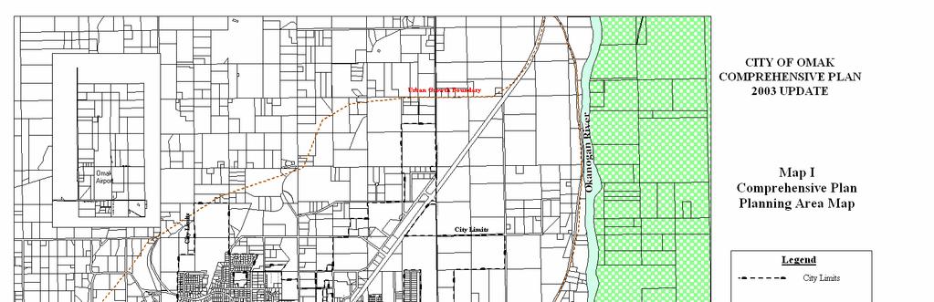
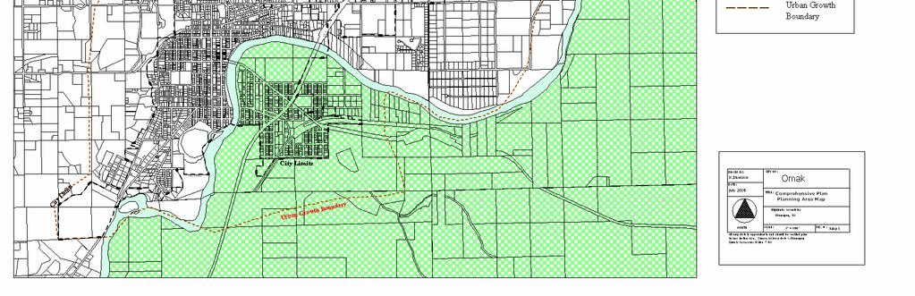
135 DRAFT COMPREHENSIVE PLAN Map Appendix I
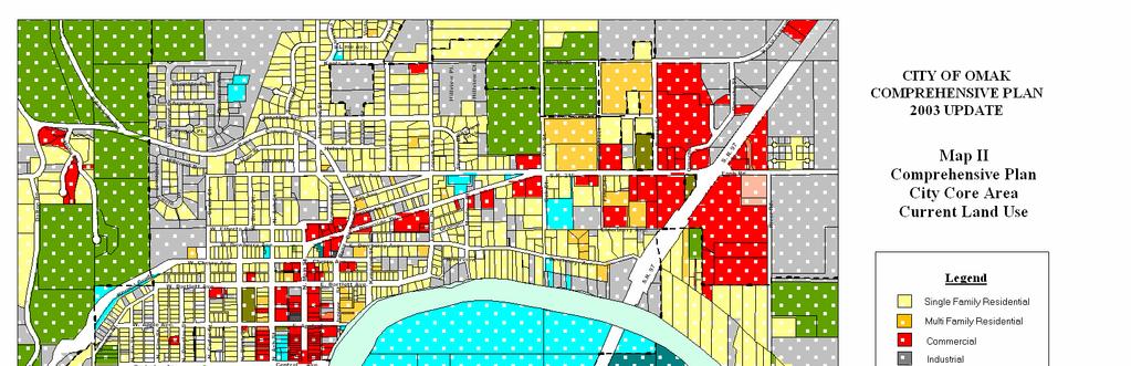
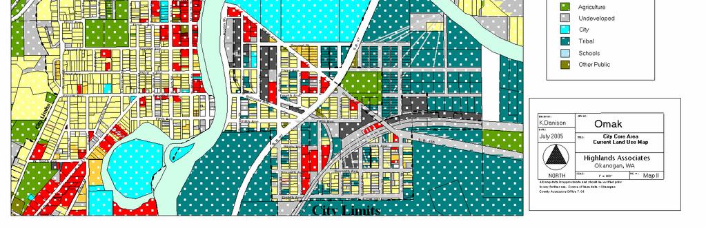
136 DRAFT COMPREHENSIVE PLAN Map Appendix II
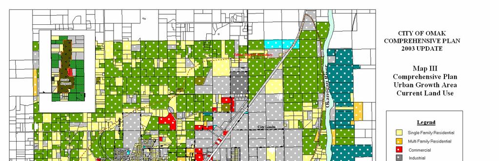
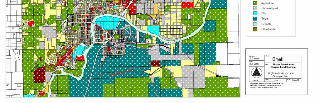
137 DRAFT COMPREHENSIVE PLAN Map Appendix III
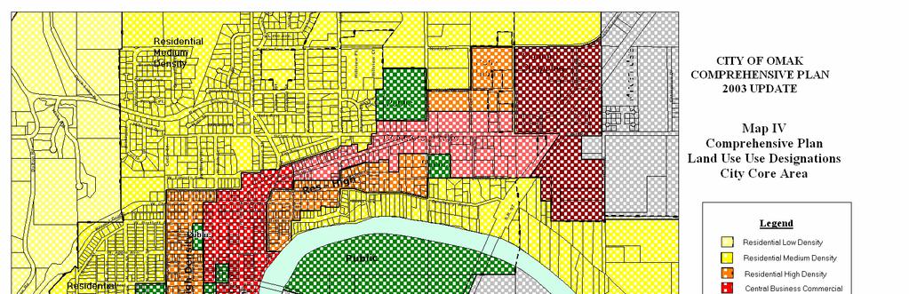
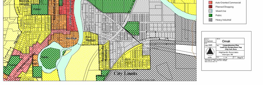
138 DRAFT COMPREHENSIVE PLAN Map Appendix IV
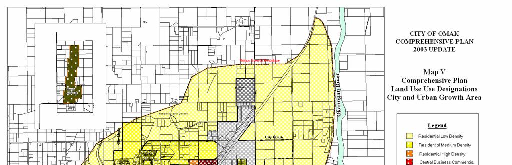
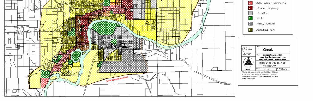
139 DRAFT COMPREHENSIVE PLAN Map Appendix V
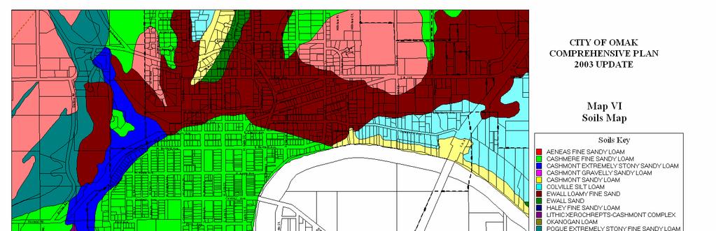
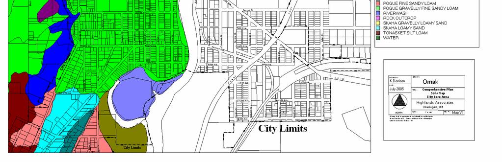
140 DRAFT COMPREHENSIVE PLAN Map Appendix VI

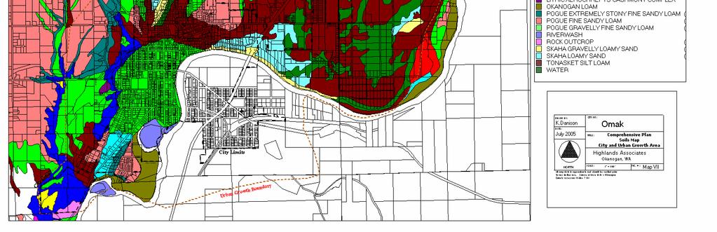
141 DRAFT COMPREHENSIVE PLAN Map Appendix VII
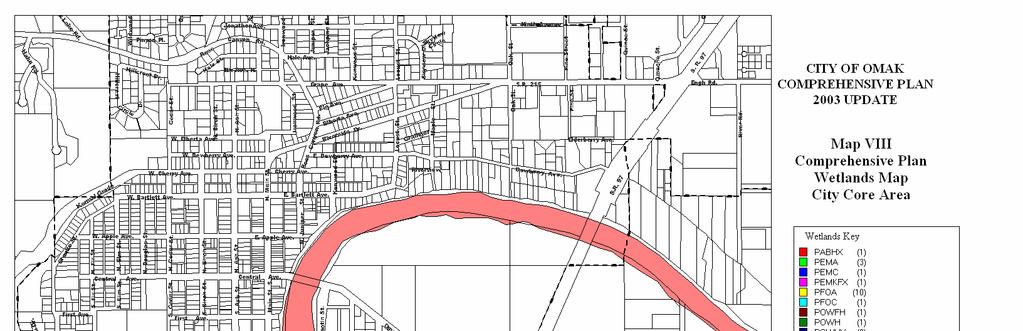
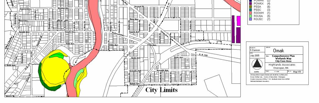
142 DRAFT COMPREHENSIVE PLAN Map Appendix VIII
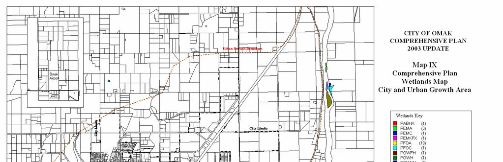
143 DRAFT COMPREHENSIVE PLAN Map Appendix IX
144 DRAFT COMPREHENSIVE PLAN Map Appendix X
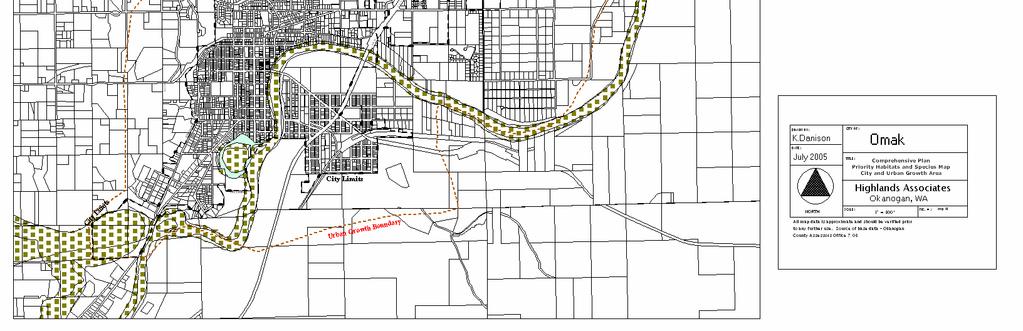
145 DRAFT COMPREHENSIVE PLAN Map Appendix XI
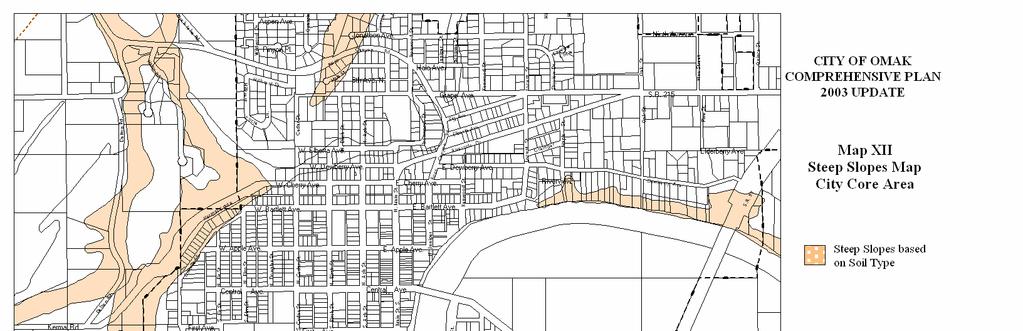
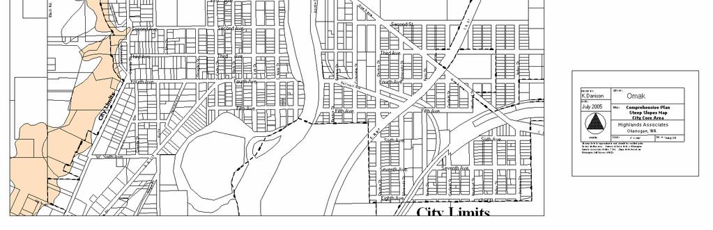
146 DRAFT COMPREHENSIVE PLAN Map Appendix XII
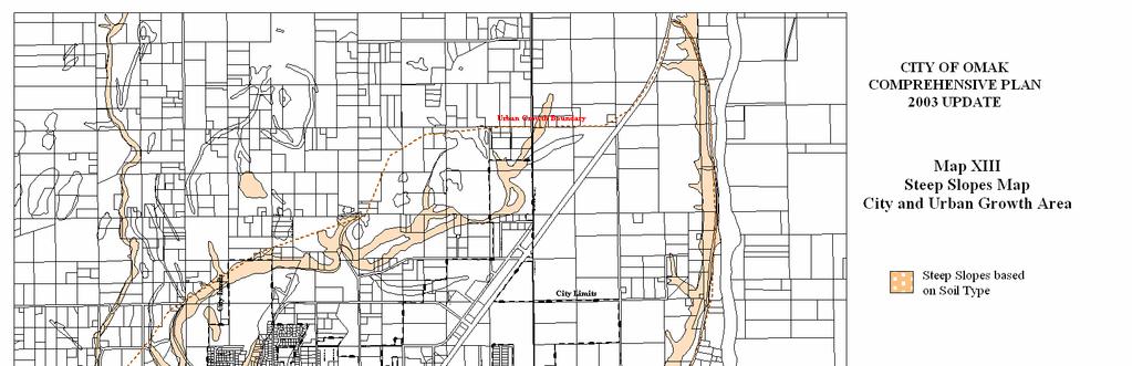
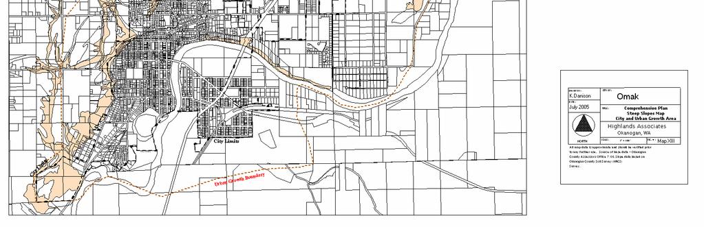
147 DRAFT COMPREHENSIVE PLAN Map Appendix XIII
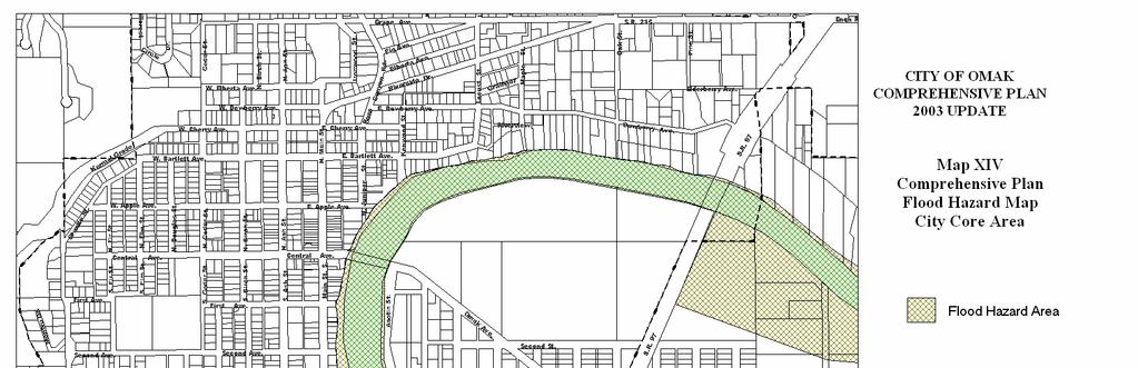
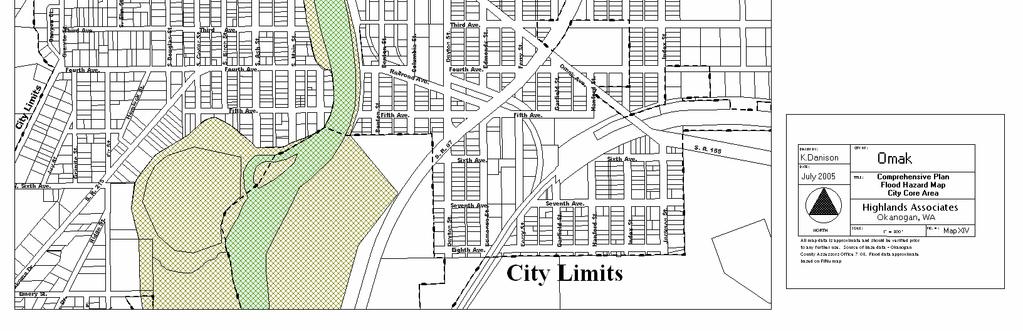
148 DRAFT COMPREHENSIVE PLAN Map Appendix XIV
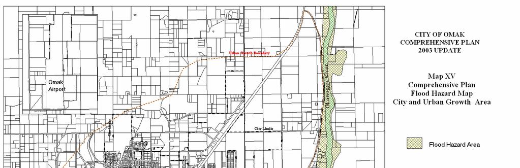
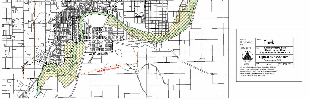
149 DRAFT COMPREHENSIVE PLAN Map Appendix XV
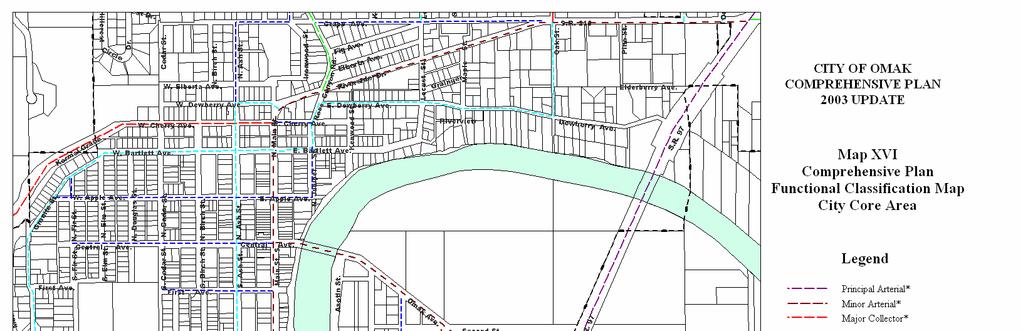
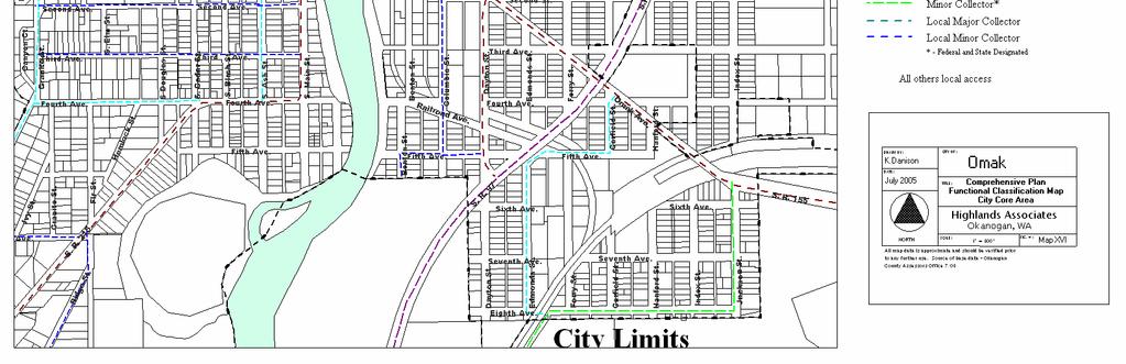
150 DRAFT COMPREHENSIVE PLAN Map Appendix XVI
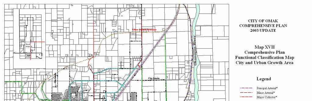
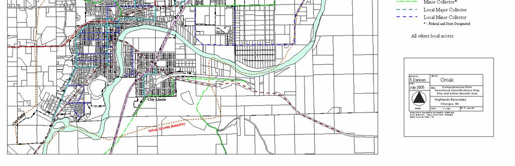
151 DRAFT COMPREHENSIVE PLAN Map Appendix XVII
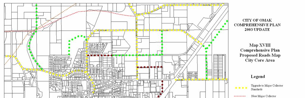
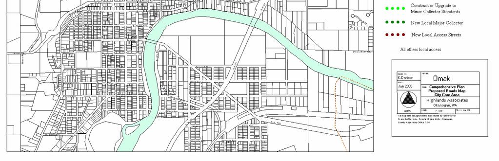
152 DRAFT COMPREHENSIVE PLAN Map Appendix XVIII
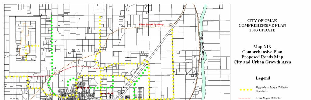
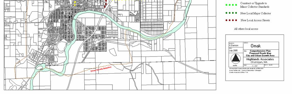
153 DRAFT COMPREHENSIVE PLAN Map Appendix XIX
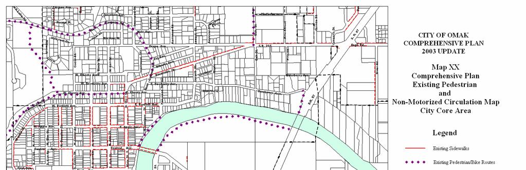
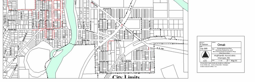
154 DRAFT COMPREHENSIVE PLAN Map Appendix XX
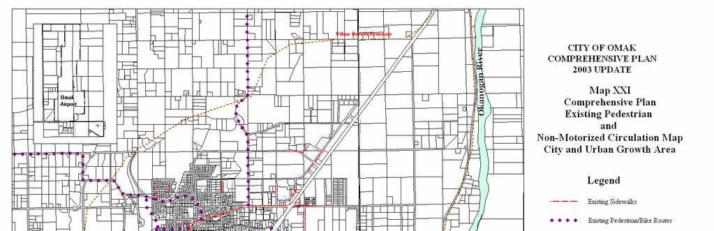
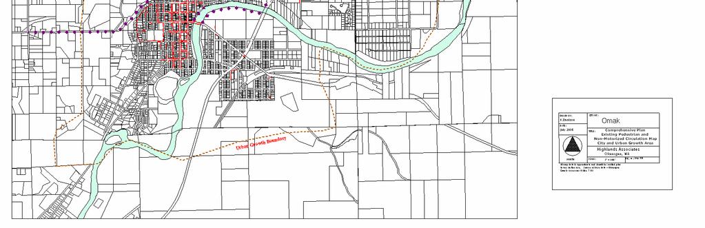
155 DRAFT COMPREHENSIVE PLAN Map Appendix XXI
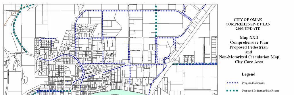
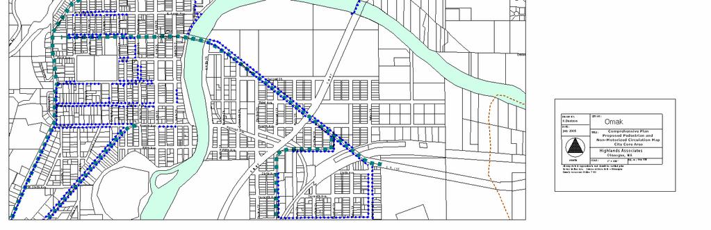
156 DRAFT COMPREHENSIVE PLAN Map Appendix XXII
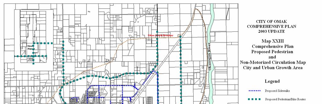
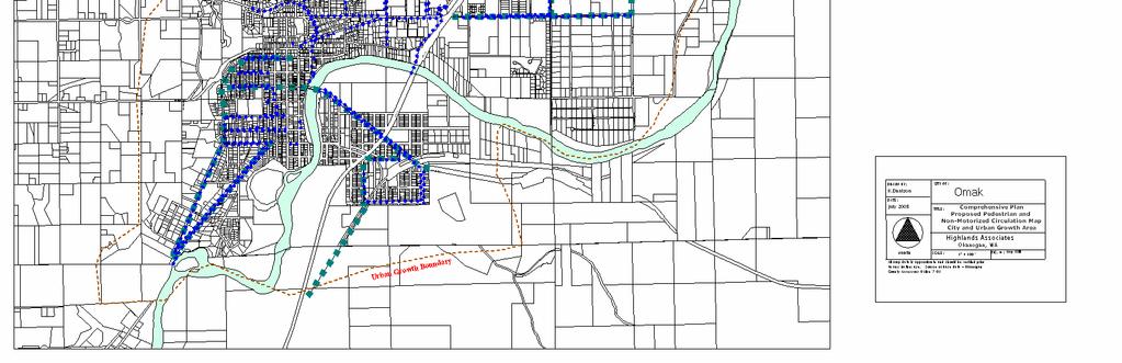
157 DRAFT COMPREHENSIVE PLAN Map Appendix XXIII
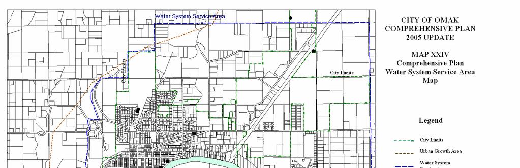
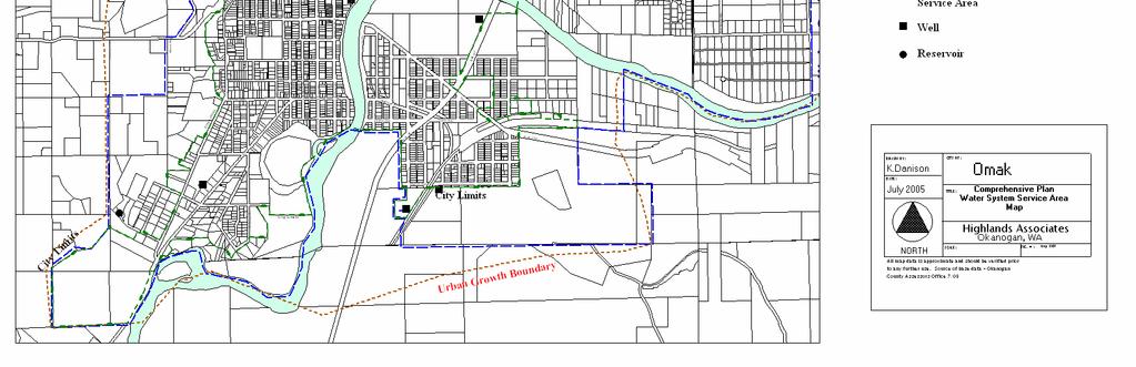
158 DRAFT COMPREHENSIVE PLAN Map Appendix XXIV
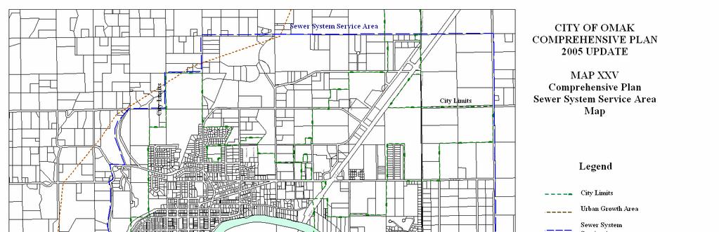
159 DRAFT COMPREHENSIVE PLAN Map Appendix XXV
160 DRAFT COMPREHENSIVE PLAN Map Appendix XXVI
PSRC REVIEW REPORT & CERTIFICATION RECOMMENDATION
 PSRC REVIEW REPORT & CERTIFICATION RECOMMENDATION KITSAP COUNTY COUNTYWIDE PLANNING POLICIES July 2, 2012 BACKGROUND A major emphasis of the Washington State Growth Management Act (GMA) is the need to
Rural Land Use Designations Kittitas County December 6, 2007 Draft
 KITTITAS COUNTY COMMUNITY DEVELOPMENT SERVICES 411 N. Ruby St., Suite 2, Ellensburg, WA 98926 CDS@CO.KITTITAS.WA.US Office (509) 962-7506 Fax (509) 962-7682 Rural Land Use Designations Kittitas County
LAND USE ELEMENT. Purpose. General Goals & Policies
 LAND USE ELEMENT Purpose This Land Use Element contains the goals and policies necessary to support the City s responsibility for managing land resources and guiding development through implementing regulations,
CHAPTER 12 IMPLEMENTATION
 CHAPTER 12 IMPLEMENTATION The 2010 Town of Denton Comprehensive Plan is intended to capture a vision of the future of Denton. As such, it provides a basis for a wide variety of public and private actions
Chapter 10 IMPLEMENTATION RECOMMENDATIONS
 Chapter 10 IMPLEMENTATION RECOMMENDATIONS The recommended land use plan presented in the previous chapter provides a design for the attainment of the urban and rural development and open space preservation
Official Plan Review
 Official Plan Review Summary Report - The Built Environment August 2014 Part 1: Introduction Planning for a healthy, prosperous and sustainable community is an important goal for our municipality. From
EXISTING COMPREHENSIVE PLAN
 EXISTING COMPREHENSIVE PLAN Town Center Land Use Element: V. LAND USE POLICIES Town Center Mercer Island's business district vision as described in "Your Mercer Island Citizen-Designed Downtown" was an
A. WHAT IS A GENERAL PLAN?
 I. Introduction A. WHAT IS A GENERAL PLAN? A general plan is the planning guideline for the future of a city. It contains goals and policies which regulate urban development, the protection of the natural
Town of Peru Comprehensive Plan Executive Summary
 Town of Peru Comprehensive Plan Executive Communities that plan grow by choice, not by chance. A plan makes growth thoughtful, understandable, and predictable. A plan shows that a community is managing
SECTION II SECTION II STATEMENT OF GOALS, OBJECTIVES, PRINCIPLES, ASSUMPTIONS, POLICIES AND STANDARDS
 STATEMENT OF GOALS, OBJECTIVES, PRINCIPLES, ASSUMPTIONS, POLICIES AND STANDARDS 1 2 STATEMENT OF GOALS, OBJECTIVES, PRINCIPLES, ASSUMPTIONS, POLICIES AND STANDARDS INTRODUCTION The New Jersey Municipal
SAN RAFAEL GENERAL PLAN 2040 INTRODUCTION AND OVERVIEW
 SAN RAFAEL GENERAL PLAN 2040 INTRODUCTION AND OVERVIEW Steering Committee Presentation February 14, 2018 Purpose of General Plan Guide land use and development decisions Coordinate transportation, infrastructure,
AREASTRUCTURE PLAN AMENDMENT COCHRANE NORTH
 AREASTRUCTURE PLAN AMENDMENT COCHRANE NORTH In order to implement the vision outlined in the Conceptual Scheme, the following three amendments to the Cochrane North ASP are proposed: 1. Allow commercial
SECTION ONE: INTRODUCTION. introduction
 introduction 1 INTRODUCTION Since it was first established in 1843 as a trading post for the Hudson s Bay Company, Victoria has evolved into a Provincial capital city that is recognized across Canada and
Ridgefield and the Growth Management Act
 1 2 Ridgefield and the Growth Management Act 3 Why Do We Plan History of Planning in Ridgefield Washington experiences rapid growth in the late 1980 s that began to change the perceived quality of life.
Woodburn Comprehensive Plan Growth Management Goals and Policies
 Goal Woodburn Comprehensive Plan Growth Management Goals and Policies G-1. The City's goal is to manage growth in a balanced, orderly and efficient manner, consistent with the City s coordinated population
Port Lavaca Future Land Use
 Port Lavaca Future Land Use Introduction The City of Port Lavaca is beginning to see sustained growth, after many years of relative stable population. New single family homes, apartments, and businesses
ROAD CLOSURE AND LAND USE AMENDMENT SILVER SPRINGS (WARD 1) NORTHEAST OF NOSEHILL DRIVE NW AND SILVER SPRINGS ROAD NW BYLAWS 2C2018 AND 29D2018
 NORTHEAST OF NOSEHILL DRIVE NW AND SILVER SPRINGS ROAD NW BYLAWS 2C2018 AND 29D2018") Page 1 of 19 EXECUTIVE SUMMARY This application proposes redesignating two parcels in the community of Silver Springs from Special Purpose Future Urban Development (S-FUD) District and undesignated road
Page 1 of 19 EXECUTIVE SUMMARY This application proposes redesignating two parcels in the community of Silver Springs from Special Purpose Future Urban Development (S-FUD) District and undesignated road
LU Encourage schools, institutions, and other community facilities that serve rural residents to locate in neighboring cities and towns.
 Application No. 891627: Comprehensive Plan Text Amendment - Rural School Policies - Amend policies consistent with State Legislation allowing schools in the rural area and extension of sewer service to
Staff Report and Recommendation
 Community Planning and Development Planning Services 201 W. Colfax Ave., Dept. 205 Denver, CO 80202 p: 720.865.2915 f: 720.865.3052 www.denvergov.org/cpd TO: City Council Neighborhoods and Planning Committee
COUNTY-WIDE PLANNING POLICIES
 Thurston County COUNTY-WIDE PLANNING POLICIES November 10, 2015 These policies were adopted by the Board of County Commissioners on September 8, 1992. They were ratified earlier by each of the seven cities
TOWN OF BRUDERHEIM Report to the capital region board
 TOWN OF BRUDERHEIM Report to the capital region board Introduction to the Town of Bruderheim Municipal Development Plan amendment and Relation to the CRB Evaluation Criteria 02 march 2017 1 Introduction
CHAPTER 3 VISION, GOALS, & PLANNING PRINCIPLES. City of Greensburg Comprehensive Plan. Introduction. Vision Statement. Growth Management Goals.
 CHAPTER 3 VISION, GOALS, & PLANNING PRINCIPLES Introduction The Greensburg Comprehensive Plan is intended as a working community document. A combination of long and short-term goals, this document is intended
EXECUTIVE SUMMARY DRAFT CHAPTER 1 INTRODUCTION EXECUTIVE SUMMARY
 CHAPTER 1 EXECUTIVE SUMMARY INTRODUCTION Through the joint efforts of the City of Tulsa planning staff and the Land Services division of Indian Nations Council of Governments (INCOG), the Berryhill Land
COMMISSION ACTION FORM
 ITEM #: 6 DATE: 09-06-17 COMMISSION ACTION FORM REQUEST: Introduction and Initial Review of Proposed Amendments to the Ames Urban Fringe Future Land Map for the North Growth Gap Area BACKGROUND INFORMATION:
City Center Specific Plan Amendments And Background Report City of Richmond. PLANNING COMMISION FINAL DRAFT January, 2001
 City Center Specific Plan Amendments And Background Report City of Richmond PLANNING COMMISION FINAL DRAFT January, 2001 TABLE OF CONTENTS Page LIST OF TABLES... LIST OF FIGURES... INDEX... OVERVIEW...
1.0 Purpose of a Secondary Plan for the Masonville Transit Village
 Report to Planning and Environment Committee To: Chair and Members Planning & Environment Committee From: John M. Fleming Managing Director, Planning and City Planner Subject: Masonville Transit Village
LAND USE OVERVIEW WHAT YOU WILL FIND IN THIS CHAPTER
 LAND USE WHAT YOU WILL FIND IN THIS CHAPTER Information about the City s expected population and employment growth. Description and capacity of existing and future land use designations. Policies that
NEW CASTLE COUNTY S ZONING DISTRICTS
 NEW CASTLE COUNTY S ZONING DISTRICTS This is general information about New Castle County s zoning districts. The information included is by no means exhaustive or complete. Before designing plans to develop
DRAFT Amsterdam/Churchill Community Plan (4/17/08) Adopted By the Gallatin County Commission
 Adopted By the Gallatin County Commission") DRAFT Amsterdam/Churchill Community Plan (4/17/08) Adopted By the Gallatin County Commission Table of Contents Acknowledgements Chapter 1: Introduction A Brief History What s Next Authority Organization
DRAFT Amsterdam/Churchill Community Plan (4/17/08) Adopted By the Gallatin County Commission Table of Contents Acknowledgements Chapter 1: Introduction A Brief History What s Next Authority Organization
STAFF SUMMARY FOR S17-02 SPECIAL USE PERMIT APPLICATION
 APPLICATION SUMMARY Case Number: S17-02 Request: STAFF SUMMARY FOR S17-02 SPECIAL USE PERMIT APPLICATION SUP application in order to develop a convenience food store. Applicant: Property Owner(s): Cindee
2040 LUP is a part of the Comprehensive Plan and carries the same legal authority. Economic Challenges
 1.1. Guiding Anchorage s Growth Where will new residents settle over the next two decades? Where will people work, shop, and play? Will there be enough room to grow? How will Anchorage look? Will growth
3.10 LAND USE SETTING PROJECT SITE EXISTING LAND USE DESIGNATIONS AND ZONING. General Plan Land Use Designations.
 This section of the Draft EIR addresses the existing land uses on and adjacent to the project site and discusses the potential impacts of the proposed project on existing land uses. Key issues addressed
I. INTRODUCTION. Project Background and Study Area
 I. INTRODUCTION Project Background and Study Area Freedom Parkway is a key east-west corridor connecting I-25 on the west to the Town of Kersey on the east, running approximately one to two miles south
Cumberland Comprehensive Plan Town Council adopted August 2003, State adopted June 2004 TABLE OF CONTENTS
 TABLE OF CONTENTS I. Executive Summary A. Scope of the Comprehensive Plan I-2 B. Plan Development Process I-3 C. Plan Format I-3 D. Acknowledgements I-4 II. Demographic Analysis A. Introduction II-1 B.
Urban Fringe Subarea Plan
 Urban Fringe Subarea Plan Updated February 27, 2018 Table of Contents Page I. Existing Goals and Policy Framework 2 A. Growth Management Act (GMA) B. County-wide Planning Policies C. Whatcom County Comprehensive
ALBEMARLE COUNTY CODE CHAPTER 18 ZONING SECTION 20A NEIGHBORHOOD MODEL - NMD
 CHAPTER 18 ZONING SECTION 20A NEIGHBORHOOD MODEL - NMD Sections: 20A.1 PURPOSE AND INTENT 20A.2 STATUS AS A PLANNED DEVELOPMENT DISTRICT 20A.5 CODES OF DEVELOPMENT 20A.6 PERMITTED USES 20A.7 RESIDENTIAL
CHAPTER 4 FUTURE LAND USE AND URBAN SERVICES DISTRICTS
 CHAPTER 4 FUTURE LAND USE AND URBAN SERVICES DISTRICTS Introduction This chapter discusses how Benzie County should grow and change in the future. A community can grow and change in many different ways.
COLVER ROAD INDUSTRIAL CONCEPT PLAN
 COLVER ROAD INDUSTRIAL CONCEPT PLAN A CONCEPTUAL LAND USE AND TRANSPORTATION PLAN FOR TA-4 AN URBAN RESERVE AREA OF THE CITY TALENT City of Talent Adopted by City Council Resolution No., June, 2015 PART
4. Shape Transitions. 4. Shape Transitions
 4. Shape Transitions 49 Zoning District Policies Overall Intent: Maintain neighborhood character by creating compatible transitions that minimize land use conflicts. Strategy: Define the character of zoning
S A C R A M E N T O C O U N T Y JACKSON HIGHWAY & GRANT LINE EAST VISIONING STUDY
 JACKSON HIGHWAY & GRANT LINE EAST S A C R A M E N T O C O U N T Y P L A N N I N G D E P A R T M E N T SUMMARY AND WORKBOOK November 19, 2008 History of the Visioning Study Sacramento County has two growth
Land Use Amendment in Southwood (Ward 11) at and Elbow Drive SW, LOC
 at and Elbow Drive SW, LOC") 2018 November 15 Page 1 of 10 EXECUTIVE SUMMARY This land use amendment application was submitted by Rick Balbi Architect on 2017 August 31 on behalf of Sable Developments Ltd, and with authorization from
2018 November 15 Page 1 of 10 EXECUTIVE SUMMARY This land use amendment application was submitted by Rick Balbi Architect on 2017 August 31 on behalf of Sable Developments Ltd, and with authorization from
This page intentionally blank.
 This page intentionally blank. Parks, Recreation, and Open Space Chapter Relationship to Vision Vision Parks, Recreation and Open Space Chapter Concepts County Government. County government that is accountable
FORMER CANADIAN FORCES BASE (CFB) ROCKCLIFFE SECONDARY PLAN. Official Plan Amendment XX to the Official Plan for the City of Ottawa
 ROCKCLIFFE SECONDARY PLAN. Official Plan Amendment XX to the Official Plan for the City of Ottawa") FORMER CANADIAN FORCES BASE (CFB) ROCKCLIFFE SECONDARY PLAN Official Plan Amendment XX to the Official Plan for the City of Ottawa 1 INDEX THE STATEMENT OF COMPONENTS PART A THE PREAMBLE PAGE Purpose...
FORMER CANADIAN FORCES BASE (CFB) ROCKCLIFFE SECONDARY PLAN Official Plan Amendment XX to the Official Plan for the City of Ottawa 1 INDEX THE STATEMENT OF COMPONENTS PART A THE PREAMBLE PAGE Purpose...
Special Joint Meeting. Emerald Isle Planning Board. Emerald Isle Board of Commissioners. January 18, 2017
 Special Joint Meeting Emerald Isle Planning Board Emerald Isle Board of Commissioners January 18, 2017 STEERING COMMITTEE: Jim Normile Town Commissioner Ken Sullivan Planning Board Larry Watson Retail
CHUGIAK-EAGLE RIVER SITE-SPECIFIC LAND USE PLAN
 CHUGIAK-EAGLE RIVER SITE-SPECIFIC LAND USE PLAN JUNE 2010 Final Prepared for The Heritage Land Bank, Municipality of Anchorage by Agnew: :Beck Consulting www.agnewbeck.com 907.222.5424 Chugiak-Eagle River
2.7 ac park. TOTAL 5,403 DU 1,297,900 sf 1,105,450 sf 3.87 ac 5,563 DU 1,121,200 sf 1,105,450 sf 3.87 ac
 PLAN AMENDMENT 2013-I-B1: SEVEN CORNERS SPECIAL STUDY Summary of Pre-staffing Comments Planner: Bernard Suchicital bsuchi@fairfaxcounty.gov (703) 324-1254 Background On October 29, 2013, the Board of Supervisors
General Location Annex, Rezone & Preliminary Plat Lansdowne Addition, Unit Three
 NEWFOUNDLAND I-5 Agricultural District Subject Site SUNDANCE ANDERSON Single Family Residential CHRISTY PUD Agricultural District Highway Business General Location Annex, Rezone & Preliminary Plat Lansdowne
LAND USE MEADOWS PLANNING AREA
 LAND USE MEADOWS PLANNING AREA I. Profile of Meadows Planning Area A. Location Meadows Planning Area is delineated by I-5 on the north, the Nisqually Bluffs representing the growth boundary on the east,
CITY OF PUYALLUP. Background. Development Services
 CITY OF PUYALLUP Development Services 333 South Meridian Puyallup WA 98371 To: City Council From: Katie Baker, AICP, Planning Division Re: South Hill Neighborhood Plan Adoption Date: (Meeting date: February
LAND USE DESIGNATIONS AND ZONING CLASSIFICATIONS
 LAND USE DESIGNATIONS AND ZONING CLASSIFICATIONS One of the most significant issues addressed within the community plan process is land use. How land is utilized within a community directly affects the
and services The protection and conservation of environmentally significant and sensitive natural heritage features and functions.
 6. Land Use 6.0 Preamble A healthy and livable city is one in which people can enjoy a vibrant economy and a sustainable healthy environment in safe, caring and diverse neighbourhoods. In order to ensure
RESOLUTION NO
 RESOLUTION NO. 13-35 A RESOLUTION OF THE CITY COUNCIL OF THE CITY OF MALIBU APPROVING GENERAL PLAN AMENDMENT (GPA) NO. 12-001, AMENDMENT TO THE GENERAL PLAN LAND USE ELEMENT AS REQUIRED TO IMPLEMENT THE
John M. Fleming Managing Director, Planning and City Planner. Old East Village Dundas Street Corridor Secondary Plan Draft Terms of Reference
 Report to Planning and Environment Committee To: From: Subject: Chair and Members Planning & Environment Committee John M. Fleming Managing Director, Planning and City Planner Old East Village Dundas Street
Definitions. Average Daily Traffic Demand (ADT): The actual number or projected number of cars that pass a point in a 24-hour period.
: The actual number or projected number of cars that pass a point in a 24-hour period.") Definitions Access Management: A combination of physical techniques and transportation policies used to control the flow of traffic between roads and the surrounding lands. Alternative City Form Scenarios:
Definitions Access Management: A combination of physical techniques and transportation policies used to control the flow of traffic between roads and the surrounding lands. Alternative City Form Scenarios:
178 Carruthers Properties Inc.
 178 Carruthers Properties Inc. Planning Rationale for 178 Carruthers Avenue Site Plan Control Application June 2014 Table of Contents 1.0 Introduction 2.0 Overview of Subject Property 3.0 Current Zoning
TRANSPORTATION AND LAND USE
 CHAPTER 10 TRANSPORTATION AND LAND USE Transportation and land use are intimately linked. The expansion of a highway typically spurs housing, employment growth and land development in the communities that
Purpose of the Master Plan
 Purpose of the Master Plan 4 Master Plan Purpose The Master Plan is a policy framework for decisions that affect the physical, social and economic environment of the Town. The Parker 2035: Master Plan
Hockessin Community Redevelopment Plan
 Hockessin Community Redevelopment Plan 3.1 Introduction The Community Redevelopment Plan for the Village of Hockessin is the result of the people s vision for a distinct village center that serves as the
City of Farmington. Downtown Plan. Amendment to the 1998 Master Plan Adopted October 11, 2004
 City of Farmington Amendment to the 1998 Master Plan Adopted October 11, 2004 Introduction Planning Background 1 Scope and Components of the Plan Amendment 2 Concept Introduction 3 Plan Concepts 3 Conceptual
GENERAL LAND USE PLAN ELEMENT
 CITY OF Prepared by City of Medford Planning Department 200 South Ivy Street Medford, Oregon 97501 plnmed@ci.medford.or.us James E. Huber, AICP, Planning Director COMPREHENSIVE PLANNING SECTION John Adam,
EXHIBIT A. Tax Increment Reinvestment Zone No. 1 (Town Center) First Amended Project Plan 1
 First Amended Project Plan 1") EXHIBIT A Tax Increment Reinvestment Zone No. 1 (Town Center) First Amended Project Plan 1 1 As amended by Resolution No. 2008-02-001(TR1R) of the Tax Increment Reinvestment Zone No.1, and approved to
EXHIBIT A Tax Increment Reinvestment Zone No. 1 (Town Center) First Amended Project Plan 1 1 As amended by Resolution No. 2008-02-001(TR1R) of the Tax Increment Reinvestment Zone No.1, and approved to
Town Center (part of the Comprehensive Plan)
") Town Center (part of the Comprehensive Plan) Mercer Island Town Center Looking North (2014) In 1994, a year-long process culminated in a set of design guidelines and code requirements for the Town Center
Town Center (part of the Comprehensive Plan) Mercer Island Town Center Looking North (2014) In 1994, a year-long process culminated in a set of design guidelines and code requirements for the Town Center
Dwelling Units Max 12 dwelling units per acre/min 8 dwelling units per acre. Development Mix 80% non residential/20% residential
 13. OSTEEN LOCAL PLAN Background: The Osteen Local Plan area is located in southwest Volusia County along the SR 415 corridor between Lemon Bluff Road and Acorn Lake Road and includes 3,990 acres. The
Purpose of the Master Plan
 Purpose of the Master Plan 4 Master Plan Purpose The Master Plan is a policy framework for decisions that affect the physical, social and economic environment of the Town. The Parker 2035: Master Plan
Executive Summary and Introduction
 Section I Executive Summary and Introduction Introduction Purpose and Implementation Vision Themes and Strategies Description of Plan Methodology and Approach History of Comprehensive Planning Page 1 of
6 PORT SYDNEY SETTLEMENT AREA
 Section 6 Port Sydney Page 61 6 PORT SYDNEY SETTLEMENT AREA 6.1 Basis and Principles Village of Port Sydney Waterfront Community Existing Services 6.1.1 Port Sydney is an historic settlement that has developed
WATERFORD Plan of Preservation, Conservation and Development Supplement Part 1 - Policy Element
 WATERFORD 2012 Plan of Preservation, Conservation and Development 2015 Supplement Part 1 - Policy Element Effective June 11, 2015 2015 Plan Update GOAL To respond to the evolving land use needs and continually
ARTICLE 6: Special and Planned Development Districts
 ARTICLE 6: Special and Planned Development Districts 6-10 Traditional Neighborhood Development (TND) District 6-10.10 Purpose and Intent The Traditional Neighborhood Development (TND) District provides
Chapter 2: Vision, Goals and Strategies
 Chapter 2: Vision, Goals and Lake Elmo Today & Tomorrow Comprehensive Plan 2040 2 VISION, GOALS & STRATEGIES - DRAFT 4-6-2018 INTRODUCTION Comprehensive Plan Purpose Perhapse the most important objective
Chelsea Creek Municipal Harbor Plan
 Chelsea Creek Municipal Harbor Plan Public Meeting #1 June 11th, 2018 1 Presentation outline I. Introduction: Why are we doing this plan? II. Evolution of Chelsea Creek III. State of Chelsea Creek IV.
Chapter Master Planned Communities (MPC) District
 District") Sections 14.53.010 Purpose and Intent 14.53.020 Applicability 14.53.030 Procedure 14.53.040 MPC Standards 14.53.050 Required Findings 14.53.010 Purpose and Intent Chapter 14.53 Master Planned Communities
Sections 14.53.010 Purpose and Intent 14.53.020 Applicability 14.53.030 Procedure 14.53.040 MPC Standards 14.53.050 Required Findings 14.53.010 Purpose and Intent Chapter 14.53 Master Planned Communities
Clackamas County Comprehensive Plan. Chapter 4: LAND USE
 Chapter 4: LAND USE When the pioneers settled Clackamas County, the land resource appeared infinite. They cleared forest, carved towns from the wilderness, and used waterways as the arterials of commerce.
City of Royalton Comprehensive Land Use Plan 2005 to Revision February 8, 2011
 City of Royalton Comprehensive Land Use Plan 2005 to 2015 2011 Revision February 8, 2011 PART ONE: INTRODUCTION TO THE COMPREHENSIVE PLAN 1.0 Purpose and Introduction The Comprehensive Land Use Plan provides
ORDINANCE WHEREAS, this Ordinance is consistent with the City of Winter Garden Comprehensive Plan; and
 ORDINANCE 17-06 AN ORDINANCE OF THE CITY COMMISSION OF THE CITY OF WINTER GARDEN, FLORIDA, CREATING ARTICLE XIV OF CHAPTER 118 OF THE CITY OF WINTER GARDEN CODE OF ORDINANCES PROVIDING FOR THE EAST PLANT
Policies and Code Intent Sections Related to Town Center
 Policies and Code Intent Sections Related to Town Center The Town Center Vision is scattered throughout the Comprehensive Plan, development code and the 1994 Town Center Plan. What follows are sections
Comprehensive Plan. Faribault, Minnesota. Hoisington Koegler Group Inc. Claybaugh Preservation Architecture Inc. Howard R. Green Company Bonz/REA
 Comprehensive Plan Faribault, Minnesota Adopted by the Faribault City Council July 8, 2003 prepared for: prepared by: Hoisington Koegler Group Inc. Claybaugh Preservation Architecture Inc. Howard R. Green
CITY OF COLWICH COMPREHENSIVE PLAN LAND USE LAND USE 1
 LAND USE LAND USE 1 WHAT YOU WILL FIND IN THIS CHAPTER: Discussion of today s conditions and tomorrow s projections Discussion of challenges and opportunities Discussion of the environmental quality goals,
SPECIFIC PLAN Requirements
 CITY OF LANCASTER PLANNING DEPARTMENT 44933 Fern Avenue, Lancaster, California 93534 (661) 723-6100 SPECIFIC PLAN Requirements Purpose The purpose of a specific plan is to provide for the logical development
Prepared by: Casey Kempenaar, Senior Planner
 CITY OF CITRUS HEIGHTS PLANNING DIVISION STAFF REPORT PLANNING COMMISSION MEETING September 13, 2017 Prepared by: Casey Kempenaar, Senior Planner REQUEST The applicant requests a Design Review Permit Modification
Subject: Hendry County Evaluation and Appraisal Report Letter of Understanding - Identification of Major Issues
 HENDRY COUNTY PLANNING & ZONING DEPARTMENT POST OFFICE BOX 2340 165 S. LEE STREET LABELLE, FLORIDA 33975 (863) 675-5240 FAX: (863) 675-5317 SUNCOM 744-4750 November 16, 2007 Mr. Mike McDaniel, Chief Office
YONGE STEELES CORRIDOR SECONDARY PLAN. Young + Wright / IBI Group Architects Dillon Consulting Ltd. GHK International (Canada) Ltd.
 Ltd.") PART A: PREAMBLE 1.0 PURPOSE The purpose of this Secondary Plan is to provide a development framework for intensification of the Yonge/ Steeles corridor including the north side of Steeles Avenue West
PART A: PREAMBLE 1.0 PURPOSE The purpose of this Secondary Plan is to provide a development framework for intensification of the Yonge/ Steeles corridor including the north side of Steeles Avenue West
CITY OF CHARLOTTESVILLE, VIRGINIA CITY COUNCIL AGENDA
 CITY OF CHARLOTTESVILLE, VIRGINIA CITY COUNCIL AGENDA Agenda Date: December 16, 2013 Action Required: Adoption of Resolution Presenter: Staff Contacts: Title: James E. Tolbert, AICP, Director of NDS James
INTRODUCTION. b. The extent to which such problems and objectives have been reduced or have increased subsequent to such date.
 INTRODUCTION INTRODUCTION The Municipal Land Use Law directs a Planning Board to prepare a Periodic Reexamination Report every six years that identifies and describes the following: a. The major problems
PORT WHITBY COMMUNITY
 PORT WHITBY COMMUNITY SECONDARY PLAN UPDATE COMMUNITY IMPROVEMENT PLAN URBAN DESIGN GUIDELINES September 2015 DRAFT PROPOSED AMENDMENT NUMBER # to the Whitby Official Plan PURPOSE: The intent of this Amendment
CITY OF LANGLEY OFFICIAL COMMUNITY PLAN BYLAW, 2005, NO APPENDIX II - REGIONAL CONTEXT MAP
 CITY OF LANGLEY OFFICIAL COMMUNITY PLAN BYLAW, 2005, NO. 2600 APPENDIX II - REGIONAL CONTEXT MAP ± Legend Agricultural Mixed Employment Industrial Conservation & Recreation Regional City Centre Urban Containment
Draft CHAPTER TWO THREE LAND USE PLAN
 CHAPTER TWO THREE LAND USE PLAN LAND USE PLAN The basic intent of the comprehensive planning process is to provide a well-founded and coordinated decision-making framework to guide both public and private
Plan Overview. Manhattan Area 2035 Reflections and Progress. Chapter 1: Introduction. Background
 Plan Overview The Manhattan Urban Area Comprehensive Plan (the Comprehensive Plan) is a joint planning initiative of the City of Manhattan, Pottawatomie County, and Riley County. The 2014 Comprehensive
A citizen s guide to the. Comprehensive Plan. City of Lakeville, Minnesota 1
 A citizen s guide to the Comprehensive Plan 2008 City of Lakeville, Minnesota 1 Introduction The City of Lakeville completed an update of its Comprehensive Plan in 2008. A comprehensive plan is a tool
CITY OF CLAREMONT MASTER PLAN 2017 CHAPTER 1: LAND USE
 CITY OF CLAREMONT MASTER PLAN CHAPTER 1: LAND USE Prepared by the Claremont Planning Board and the Claremont Planning and Development Department Vision Claremont Master Plan Chapter 1: Land Use Claremont
CONTENTS 8.0 LAND USE 8.1 GENERAL LAND USE 8.2 RESIDENTIAL 8.3 MIXED USE 8.4 COMMERCIAL 8.5 EMPLOYMENT LANDS
 8-2 Land Use 8.0 LAND USE CONTENTS 8.1 GENERAL LAND USE 8.1.1 Uses provided for in all Land Use Designations 8.1.2 Uses prohibited in Hazardous Lands, Hazardous Sites and Special Policy Areas 8.1.3 Uses
POLICY AMENDMENT AND LAND USE AMENDMENT KILLARNEY/GLENGARRY (WARD 8) NW CORNER OF RICHMOND ROAD AND 33 STREET SW BYLAWS 1P2015 AND 7D2015
 NW CORNER OF RICHMOND ROAD AND 33 STREET SW BYLAWS 1P2015 AND 7D2015") Page 1 of 13 EXECUTIVE SUMMARY This application seeks to redesignate an RC-2 (Residential Contextual One/Two Dwelling) parcel to MC-Gd72 (Multi-Residential Contextual Grade-Oriented) to allow for multi-residential
Page 1 of 13 EXECUTIVE SUMMARY This application seeks to redesignate an RC-2 (Residential Contextual One/Two Dwelling) parcel to MC-Gd72 (Multi-Residential Contextual Grade-Oriented) to allow for multi-residential
V. Vision and Guiding Principles
 V. Vision and Guiding Principles The Master Plan for the Powers Ferry Corridor seeks a foundation in the desires of the community. At times, various elements of the community offered opposing viewpoints,
Capital Area Regional Planning Commission. DANE COUNTY LAND USE & TRANSPORTATION PLAN Amended Goals and Objectives
 Capital Area Regional Planning Commission DANE COUNTY LAND USE & TRANSPORTATION PLAN Amended Goals and Objectives CARPC Redline Review Draft 12/14/07 as amended and adopted on 2/28/08* *changes indicated
The following rules shall be used to determine the precise location of any zone boundary shown on the Official Zoning Map of Auburn:
 ARTICLE III. ESTABLISHMENT OF ZONING DISTRICTS Section 300. Establishment of Zoning Districts. The City of Auburn, Alabama is hereby divided into zoning districts of such number and character as are necessary
2010 Plan of Conservation and Development
 2010 Plan of Conservation and Development Wilton Planning and Zoning Commission Adopted November 2, 2009 Effective January 1, 2010 WILTON 2010 PLAN OF CONSERVATION & DEVELOPMENT PARTICIPANTS Planning &
PLANNED UNIT DEVELOPMENT & SUBDIVISION STAFF REPORT Date: May 18, 2017
 & PUD-0000102-2017 PLANNED UNIT DEVELOPMENT & SUBDIVISION STAFF REPORT Date: May 18, 2017 NAME SUBDIVISION NAME Dauphin Creek Estates Subdivision Dauphin Creek Estates Subdivision LOCATION CITY COUNCIL
SECTION UNIFIED DEVELOPMENT ORDINANCE SECTION Part 1 Ordinance. ARTICLE 1 Zoning Districts
 SECTION 1-100 UNIFIED DEVELOPMENT ORDINANCE SECTION 1-300 Part 1 Ordinance SECTION 1-100. Introduction. ARTICLE 1 Zoning Districts Crystal Lake strives to maintain a balance of various land uses for a
Cumberland Region Tomorrow is a private, non-profit, citizen based regional organization working with Greater Nashville Regional Council
 Cumberland Region Tomorrow is a private, non-profit, citizen based regional organization working with Greater Nashville Regional Council and others in the public and private sectors, dedicated to planning
PLANNING ADVISORY BOARD AGENDA OCTOBER
 ! City of Langley PLANNING ADVISORY BOARD AGENDA OCTOBER 1, 2014 3-5pm LANGLEY CITY HALL - 112 2 nd Street, Langley WA 1) Call to Order and Roll Call 2) Approval of the Minutes September 10, 2014 3) Public
HAMLET OF KINGMAN AREA STRUCTURE PLAN
 HAMLET OF KINGMAN AREA STRUCTURE PLAN Prepared by: Austrom Consulting Ltd. Page 1 of 19 Table of Contents TABLE OF CONTENTS... 2 1. BACKGROUND... 3 1.1 PLAN AREA... 3 1.2 PLAN PURPOSE... 3 1.3 LEGISLATIVE