Prepared by Beth Elliott
|
|
|
- Leslie Martin
- 5 years ago
- Views:
Transcription
1 Prepared by Beth Elliott In cooperation with the Neighborhood Planning for Community Revitalization (NPCR) Program and the West Calhoun and Cedar-Isles-Dean Neighborhoods of Minneapolis June 2002
2 Table of Contents EXECUTIVE SUMMARY INTRODUCTION CONTEXTUAL INFORMATION THE MINNEAPOLIS PLAN DEMOGRAPHICS EXISTING AND ADJACENT LAND USE PLANS EXISTING PLANS ADJACENT PLANS COMMUNITY INPUT SURVEY RESULTS SURVEY ANALYSIS OPPORTUNITY SITES CREATING A SENSE OF PLACE IMPROVING NEIGHBORHOOD TRANSPORTATION CONCLUSION APPENDICES
3 Executive Summary The Cedar-Isles-Dean Neighborhood Association (CIDNA) and the West Calhoun Neighborhood Council (WCNC) are collaborating on a project that aims to improve beautification, recreation, traffic flow, and pedestrian access of the business district of Calhoun Commons and Calhoun Village, plus some of the surrounding residential/commercial areas. This area of the two neighborhoods is known as the Calhoun Gateway, and it has the boundaries of France Avenue South on the west, Midtown Greenway on the north, Thomas Avenue on the east, and West 32 nd Street on the south. A Small Area Plan is used mainly to guide future land use in a portion of a city. In the case of Minneapolis, it is an informal process that provides an opportunity for neighborhoods to have a hand in the physical design of their community as a long-term vision. The Calhoun Gateway Small Area Plan will be referred to when WCNC and CIDNA acquire funds to use for the betterment of their neighborhoods. Contextual Information The Calhoun Gateway falls primarily between two community corridors within the Calhoun-Isles community - West Lake Street and Excelsior Boulevard. These two streets have been named community corridors under Minneapolis comprehensive plan, The Minneapolis Plan. A community corridor supports: Consolidating commercial uses Promoting viable street life during the day and evening by encouraging a mix of uses at appropriate locations Strengthening the residential character by developing a variety of housing types Enhancing the pedestrian environment Within the area comprised of the West Calhoun and CIDNA neighborhoods, the total population from 2000 is 4,563 residents with 59 percent living in CIDNA. From 1990 to 2000, West Calhoun saw a decrease in its population by a mere 0.5 percent while CIDNA enjoyed an increase of over 20 percent in that ten-year period. The fastest-growing age group in both neighborhoods from 1990 to 2000 is for those people who fall within the age bracket of years. Within the area comprising both neighborhoods, seven percent of the population in 2000 identified with being non-white. This compares 3
4 to the identification of almost 35 percent of the total Minneapolis population of 382,618 people as non-white. The total number of households within both neighborhoods is 2,756 with both CIDNA and West Calhoun sharing almost an equal percentage. The total number of housing units in the two neighborhoods is 2,888; 60 percent (1733 units) of those are renter-occupied. This is an increase of 13.3 percent from 1990 to In 2000, 62.9 percent of the renter-occupied housing units fell within the West Calhoun neighborhood boundaries. Existing and Adjacent Land Use Plans Many land use plans have been created within the study area as well as in adjacent neighborhoods. It is not only good to frame new and innovative ideas for the Calhoun Gateway Small Area Plan, but also to build a connection to these past land use plans. Additionally, the Small Area Plan should be compatible and enhance the plans created for adjoining neighborhoods. Existing plans include: Cedar-Isles-Dean NRP Neighborhood Action Plan West Calhoun NRP Neighborhood Action Plan Excelsior Boulevard Corridor Study Adjacent plans include: Lake Street Midtown Greenway Corridor Framework Plan Park Commons, St. Louis Park All of the land use plans have common themes of forming community identities and creating a more livable, human-scale environment for people using all modes of transportation. The NRP plans helped the two neighborhoods to gain access to city funds in order to accomplish some of their neighborhood goals, while all the land use plans aim to create a unity between their study areas and the surrounding districts. 4
5 Community Input The most important aspect of any planning process is public participation, particularly in the creation of a Small Area Plan where the neighborhoods decide their own future land uses. In the case of the Calhoun Gateway, many stakeholders were involved in the planning of ideas. They included: Residents owners and renters Business owners Board members NRP staff Neighborhood input was gathered through informal interviews, attendance at neighborhood meetings, and a survey of West Calhoun and CIDNA residents. All households within the two neighborhoods received the survey, and 235 residents sent back surveys for a return rate of nine percent. CIDNA residents comprised 57 percent of returned surveys, while West Calhoun residents were 43% percent. Some survey highlights: 93 percent (215) of respondents use a car as their primary mode of transportation 36 percent (84) use the greenway paths to travel to destinations within the immediate area Proximity to Uptown and Downtown rated as the highest asset among respondents Most residents find traffic to be an overwhelming downfall in the area Calhoun Village is preferred to Calhoun Commons The survey results indicate that residents have an overall feeling of satisfaction with the commercial and residential portions of their neighborhoods. Residents appreciate the beauty of their surroundings, including the lakes and open green spaces throughout the neighborhoods. Overall, West Calhoun and CIDNA stakeholders enjoy the amenities found within the neighborhoods. 5
6 Opportunity Sites General and specific land use planning ideas became apparent through information received from neighborhood meetings, interviews, and surveys. The Calhoun Gateway and its surrounding area offer a number of amenities for residents, however some improvements can be made in the future. Ideas to improve the Calhoun Gateway are meant to perform two different tasks. They are: Creating a Sense of Place Improving Neighborhood Transportation Creating a Sense of Place The Calhoun Gateway within the West Calhoun and CIDNA neighborhoods needs to create identifiable features so visitors know they have entered a worthwhile part of the city, but residents also should feel a sense of attachment to their surroundings. This is especially important since the two neighborhoods are an entry point for many non-residents coming from western suburbs. One particular technique used to accomplish such a task is to create some common visual features found throughout the Calhoun Gateway with art as the dominant theme. Such features include: Banners Landscaping Pedestrian-Scale Lighting Transit Amenities Improving Neighborhood Transportation Many of the ideas and concerns for the improvement of neighborhood transportation emphasize creating an infrastructure that accommodates a variety of transportation modes. This means slowing traffic and dreaming up ways to make the Calhoun Gateway more human-scale rather than catered to automobiles in a suburban strip mall fashion. Improvements pertain to: Lake Street Bridge Lake Street/Excelsior Boulevard Bus Shelters Signage for the Midtown Greenway 6
7 Pedestrian Bridge Commercial Parking Lots West Calhoun Access Point This Small Area Plan of the Calhoun Gateway is just the first step in the process of creating ideas for future land uses in the West Calhoun and Cedar-Isles-Dean neighborhoods. Based on the objectives of existing neighborhood plans and community input, this document will hopefully act as a guide in further decision-making. 7
8 Introduction The Cedar-Isles-Dean Neighborhood Association (CIDNA) and the West Calhoun Neighborhood Council (WCNC) are collaborating on a project that aims to improve beautification, recreation, traffic flow, and pedestrian access of the business district of Calhoun Commons and Calhoun Village, plus some of the surrounding residential/commercial areas. This area of the two neighborhoods is known as the Calhoun Gateway, and it has the boundaries of France Avenue South on the west, Midtown Greenway on the north, Thomas Avenue on the east, and West 32 nd Street on the south. A Small Area Plan is used mainly to guide future land use in a portion of a city. In the case of Minneapolis, it is an informal process that provides an opportunity for neighborhoods to have a hand in the physical design of their community as a long-term vision. The Calhoun Gateway Small Area Plan will be referred to when WCNC and CIDNA acquire funds to use for the betterment of their neighborhoods. As a graduate student studying urban planning at the University of Minnesota, I have been hired to draft land use plans for the Calhoun Gateway. I grew up in the CIDNA neighborhood, which I believe gives me a good sense of its past as well as how it can be improved for the future. The creation of land use plans is important for guiding future growth, development, and land use alterations. My research and suggestions will hopefully guide the improvement of infrastructure and resources in the area for enjoyment by residents and visitors to be compatible with the built environment. 8
9 Contextual Information The Minneapolis Plan The Calhoun Gateway falls primarily between two community corridors within the Calhoun-Isles community - West Lake Street and Excelsior Boulevard. These two streets have been named community corridors under Minneapolis comprehensive plan, The Minneapolis Plan. According to The Minneapolis Plan, community corridors are streets that connect neighborhoods, carry a moderate volume of traffic, and have a primarily residential character but support low-intensity mixed use at key intersections. 1 West Lake Street and Excelsior Boulevard are community corridors. A community corridor supports: Consolidating commercial uses Promoting viable street life during the day and evening by encouraging a mix of uses at appropriate locations Strengthening the residential character by developing a variety of housing types Enhancing the pedestrian environment The West Calhoun and Cedar-Isles-Dean neighborhoods lie within the Calhoun-Isles area of Minneapolis (for a map of neighborhood boundaries, see Appendix A). Both neighborhoods are entry points to the city from the western suburbs of St. Louis Park and Edina, which gives them the opportunity to provide a context of Minneapolis for visitors arriving from the Both neighborhoods are entry points from western suburbs. 1 From The Minneapolis Plan s section on Community Corridors. 9
10 west. Many of the patrons to the retail stores within the neighborhoods are from these and further suburban areas. Demographics Within the area comprised of the West Calhoun and CIDNA neighborhoods, the total population from 2000 is 4,563 residents with 59 percent living in CIDNA. 2 From 1990 to 2000, West Calhoun saw a decrease in its population by a mere 0.5 percent while CIDNA enjoyed an increase of over 20 percent in that ten-year period. The total combined population of the neighborhoods is 4,563. Age The median age of a West Calhoun resident in 2000 was 31.6 years old, where 42 years old was the median age of residents in the CIDNA neighborhood. The fastest-growing age group in both neighborhoods from 1990 to 2000 is for those people who fall within the age bracket of years. Only 54 of the 1,865 West Calhoun residents are under the age of 18, while CIDNA has 304 of its 2,698 fall into the same age category. Race or Ethnicity Within the area comprising both neighborhoods, seven percent of the population in 2000 identified with being non-white. This compares to the identification of almost 35 percent of the total Minneapolis population of 382,618 people as non-white out of the 2,698 residents in CIDNA are Black or African-American, which is an increase of over 152 percent from West Seven percent of the neighborhoods identify as non-white. 2 All neighborhood demographic information was found through the City of Minneapolis website ( 3 Minneapolis demographic information for 1990 and 2000 was compiled from the U.S. Census Bureau s American FactFinder ( 10
11 Calhoun experienced a 31.3 percent decrease in the number of Black or African- American residents from 1990 to 2000 from 80 to 55 of its residents. The entire city saw a 30 percent increase in the number of residents identifying with this race. The amount of Asian, Native Hawaiian or Other Pacific Islander residents grew substantially in both neighborhoods. In CIDNA, residents of this race grew by percent to 59 people in West Calhoun experienced an 88.1 percent growth from 1990 to 2000 to 79 residents. The city saw a similar growth in residents identifying with this race 150 percent growth from 15,723 in 1990 to 23,744 in A larger number of Asian, Native Hawaiian or Other Pacific Islanders have moved into the neighborhoods. Forty residents (2 percent) of West Calhoun have an ethnic origin of Hispanic or Latino, which is an increase of 8.1 percent from 1990 to In the same period, the CIDNA neighborhood lost 6.1 percent of its Hispanic or Latino residents. Household Characteristics The total number of households within both neighborhoods is 2,756, where CIDNA has a mere one percent higher household population than West Calhoun. However, only 41 households in West Calhoun have individuals under the age of eighteen while CIDNA has 176. The total number of housing units in the two neighborhoods is 2,888; 60 percent (1733 units) of those are renter-occupied. This is an increase of 13.3 percent from 1990 to In 2000, 62.9 percent of the renter-occupied housing units fell within the West Calhoun neighborhood boundaries. The total number of households in the two neighborhoods is 2,756 with almost an equal distribution. 60 percent of housing units are rental. 11
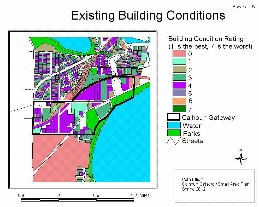
12 Table 1 below shows summary statistics from Census 2000 comparing the West Calhoun and Cedar-Isles-Dean neighborhoods. Table TOTAL POP. MEDIAN AGE (YRS) % NON-WHITE # HOUSING UNITS West Calhoun 1, % 1,391 Cedar-Isles-Dean 2, % 1,497 TOTAL 4,563 N/A N/A 2,888 Source: City of Minneapolis Planning Department, Research and Strategic Planning Division. October Existing Building Conditions Of the sixty-four parcels located within the Calhoun Gateway, thirty-four have been assigned a rating of 4, or average, by the Minneapolis city assessor. Buildings are rated on a scale of 1-7 where 1 is the best and 7 is the worst. Only three parcels have a rating of 1. Seven buildings have been given a rating between 5 and 7. To view a map of existing building conditions, see Appendix B. The city assessor considers half of the buildings within the Calhoun Gateway average. All of this information is meant to set a context of the two neighborhoods and the Calhoun Gateway. Even though the demographics are not extensive, they may help in deciphering trends in the area that can guide future land use decisions. 12
13 Existing and Adjacent Land Use Plans Many land use plans have been created within the study area as well as in adjacent neighborhoods. It is not only good to frame new and innovative ideas for the Calhoun Gateway Small Area Plan, but also to build a connection to these past land use plans. Additionally, the Small Area Plan should be compatible and enhance the plans created for adjoining neighborhoods. To find existing land use and zoning maps of the Calhoun Gateway within West Calhoun and CIDNA, see Appendix C and Appendix D. Existing Plans Cedar-Isles-Dean NRP Neighborhood Action Plan Ratified in October 1994, this plan lays out neighborhood goals in order to receive funds through the Minneapolis Neighborhood Revitalization (NRP) Program. The Cedar-Isles-Dean Neighborhood Action Plan envisioned a neighborhood with a strong sense of community identity while also forming connections to adjoining neighborhoods. Issues: CIDNA lacks a strong sense of community The commercial district is oriented away from the neighborhood There are no central gathering places Commuter traffic on residential streets Existing plans include: Cedar-Isles-Dean NRP Neighborhood Action Plan West Calhoun NRP Neighborhood Action Plan Excelsior Boulevard Corridor Study The main purpose of the plan was to state neighborhood goals and suggest ways to meet them. Strategies suggested to work toward the alleviation of 13
14 neighborhood issues included: Strategies: Identify entrances to the neighborhood through signage and landscaping Create convenient pedestrian and bicycle connections to the commercial area Seek out a site for Neighborhood Early Learning Center to provide a variety of family services and community meeting space Implement traffic calming techniques through the redesign of dangerous or confusing intersections West Calhoun NRP Neighborhood Action Plan The West Calhoun neighborhood ratified their NRP Neighborhood Action Plan in April 1999 after three years of preparation. It was intended not to change the character of the community, but to unify it and improve livability. Some issues West Calhoun faced include: Issues: The neighborhood is fragmented with large portions in institutional ownership (the Park Board, the Minikahda Club, and the railroad) About 80 percent of the neighborhood residents are renters The neighborhood lacks convenient pedestrian and bicycle connections between Lake Calhoun, the Village Center, and the Midtown Greenway The West Calhoun neighborhood lacks convenient pedestrian and bicycle connections to major neighborhood destinations. Through a process geared toward neighborhood input, some key strategies were recognized to achieve the stated goals. The Action Plan includes extended funding information and timelines for all the strategies. Strategies: 14
15 Create partnerships in order to make physical connections for residents throughout the neighborhood Include a diverse group of residents in the planning process Improve pedestrian infrastructure through widening sidewalks, using bollards, installing retaining walls, and the striping of crosswalks Excelsior Boulevard Corridor Study Written in September 1998, the corridor study was the first step in creating a master plan for the corridors in the West Calhoun neighborhood. The aim of the master plan is to make Excelsior Boulevard and West Calhoun Parkway more pedestrian-friendly through traffic-calming efforts, crosswalks, and sidewalks. Excelsior Boulevard is West Calhoun s Main Street, and it also connects Minneapolis to St. Louis Park. The master plan aims to make West Calhoun more pedestrian friendly. Neighborhood design principles discussed in the study include: Evoke a strong sense of neighborhood identity, creating a unique gathering place for both residents and visitors Invest in the public realm Broaden the mix of land uses, incorporating mixed-use where possible Improve connectivity while providing a balanced and accessible network of movement Celebrate existing strengths Promote public safety and security Encourage environmental responsibility and sustainability The study was separated into four phases that began with site analysis and 15
16 data collection and ended with the submission of final documents. The last three phases included community meetings open to the general public. Adjacent Plans Lake Street Midtown Greenway Corridor Framework Plan This plan was prepared in June 1999, and it discusses the revitalization of Lake Street in coordination with the development of the Midtown Greenway. One of the main goals of the plan was to direct attention to the rich history and potential for the rail corridor and Lake Street to be a place for recreation and celebration in Minneapolis. Adjacent plans include: Lake Street Midtown Greenway Corridor Framework Plan Park Commons, St. Louis Park The Framework Plan describes the potential for revitalization in the Lake Street/Midtown Greenway corridor by focusing on six areas: West Calhoun Gateway Hennepin Avenue and Lake Street Urban Village South Whittier Redevelopment Plan Nicollet Avenue Re-Opening 4 th and Lake Redevelopment Plan The focus on West Calhoun mainly pertains to the development of Calhoun Commons as a Village Center on the lake. Through focusing on specific sites along the corridor, planners have the opportunity to revitalize specific neighborhoods as well as form connectivity throughout the city. 16


17 Park Commons, St. Louis Park Park Commons is a redevelopment plan that will encompass many changes along Excelsior Boulevard, a major thoroughfare shared with the West Calhoun neighborhood to its east. 4 The project is designed to create a downtown area for this first-ring suburb, and one goal is that all strip mall developments will be replaced with a traditional town center. The project has a timeline of 25 years to implement all plans. Park Commons will function as a center for St. Louis Park and a regional destination for work, shopping, and recreation. One noticeable change that has occurred to date is the installation of bricked crosswalks at close intervals across Excelsior Boulevard. The crosswalks provide a more stable environment for pedestrians, and they help to alleviate some of the physical and psychological barriers that arise along a busy and wide street. Proposed Park Commons streetscape Revitalization features include: Mixed uses Mixed-income housing Pedestrian/bicycle connections to Wolfe Park Underground parking A transit hub Park Commons redevelopment area 4 Information found at the City of St. Louis Park What is Park Commons? as well as through Met Council s LCDA grant award recipients. 17
18 Community Input The most important aspect of any planning process is public participation, particularly in the creation of a Small Area Plan. The City of Minneapolis instituted an informal Small Area Plan process with the intention of placing the decision-making authority at the local level so as to allow neighborhoods to decide for themselves how they would look and feel. In the case of the Calhoun Gateway, many stakeholders were involved in the planning of ideas. They included: Residents owners and renters Business owners Board members NRP staff Neighborhood input was gathered through informal interviews, attendance at neighborhood meetings, and a survey of West Calhoun and CIDNA residents. After all the information was compiled, trends in neighborhood assets and liabilities arose that shaped the rest of the Small Area Plan. The stakeholders also created a wish list for what they would like to see occur in the study area, and sample answers can be found in Appendix E. All households within the two neighborhoods received the survey, and 235 residents sent back surveys for a return rate of nine percent. At the annual meetings of both neighborhoods, a drawing was held among the returned surveys for gift certificates to restaurants in Calhoun Village and Calhoun Commons. Even though the return rate is low, residents expressed many Neighborhood input was gathered through interviews, neighborhood meetings, and a survey. 235 households returned the survey. 18
19 worthwhile opinions and ideas on their neighborhood and the surrounding area. Survey Results Among the 235 households that returned the survey, CIDNA residents were 57 percent (135) of the total. 45 percent of the CIDNA residents have lived in the neighborhood for over ten years, and 74 percent of the West Calhoun residents have lived in their neighborhood for under ten years. Among all the surveys, twenty-five of the residents have lived in their home for over 25 years. Transportation 93 percent (215) of respondents use a car as their primary mode of transportation. A mere three percent use a bicycle as their primary mode of transportation, and both public transportation and walking were indicated in eight percent of the survey results. 5 Seven percent of the respondents use the greenway paths located throughout the neighborhoods for commuting purposes. More importantly, 36 percent (84) use the paths to travel to destinations within the immediate area. CIDNA residents comprised 57% of returned surveys, while West Calhoun residents were 43%. 93% rely on their car for getting around. 36% use the greenway paths to travel through the immediate neighborhood. Neighborhood Assets Respondents were asked whether they believe five different things to be assets in this area of Minneapolis that other areas do not have: Concentration of retail Recreational amenities 5 Some respondents indicated more than one primary mode of transportation. 19
20 Mix of housing types Proximity to the lakes Close to Uptown and Downtown The fact that the area is close to Uptown and Downtown ranked the highest with 98 percent of respondents viewing it as an asset. The concentration of retail (97%) and the proximity to the city lakes (94%) also ranked well as assets for residents. 71 percent believe recreational amenities are an asset, and only 35 percent of the residents found the mix of housing types to be an asset. Proximity to Uptown and Downtown rated as the highest asset among respondents. Neighborhood Downfalls The options provided to respondents on the area s biggest downfalls included: Concentration of retail Traffic Lack of landscaping on public thoroughfares Lack of neighborhood identity The survey found that traffic is the most overwhelming downfall in the area with 76 percent. The excessive amount of traffic was also mentioned by the majority of respondents in another question asking about their least favorite part of the commercial and residential neighborhood, mainly emphasizing traffic during peak commuting hours at the corner of Lake Street and Dean Parkway. The lack of landscaping along public thoroughfares is considered another downfall by 17 percent of respondents. Otherwise, the other statistics proved inconsequential. Most residents find traffic to be an overwhelming downfall in the area. Commercial Centers Respondents were asked whether they shop at Calhoun Commons and 20
21 Calhoun Village, and then they were to choose which they preferred. Many of the residents did not have a preference, but over half did indicate which they liked better; 83 (70%) prefer Calhoun Village to Calhoun Commons. Many residents had concerns with the amount of congestion in the parking lot of Calhoun Commons, and others felt that Calhoun Village has a better variety of stores that fit their lifestyles. Numerous respondents pointed out that a hardware store would add greatly to that variety. Many of the respondents who prefer Calhoun Commons find it more aesthetically pleasing. Only a couple residents expressed a dislike of the amount of commercial uses in the area. Calhoun Village is preferred to Calhoun Commons. Survey Analysis The survey results indicate that residents have an overall feeling of satisfaction with the commercial and residential portions of their neighborhoods. Even though most people use their cars when leaving the area, many prefer to walk via the greenway paths to arrive at neighborhood destinations. When they travel either by walking or driving to Calhoun Commons or Calhoun Village, they are patronizing a variety of stores but sometimes finding it difficult to navigate through both parking lots. Residents appreciate the beauty of their surroundings, including the lakes and open green spaces throughout the neighborhoods. They like to be able to access the greenways and lake paths for recreation and exercise, but residents sometimes find it difficult to cross busy intersections. Overall, West Calhoun and CIDNA stakeholders enjoy the amenities found within the neighborhoods. 21
22 Opportunity Sites General and specific land use planning ideas became apparent through information received from neighborhood meetings, interviews, and surveys. Residents and business owners appreciate the beauty and resources provided within West Calhoun and CIDNA, however the concepts and specific sites explained in this section will hopefully act as a catalyst in creating an environment that can further enhance their love of the community. The Calhoun Gateway and its surrounding area offer a number of amenities for residents, however some improvements can be made in the future. This section includes a brief explanation of two urban planning concepts that comprise the majority of improvements along the Calhoun Gateway. They are: Creating a Sense of Place Improving Neighborhood Transportation Improvements that will help to: Create a sense of place Improve neighborhood transportation Within each of the planning concepts, various specific improvement sites are described. Each site is explained and then followed with anecdotal information on how to improve it. This is not an exhaustive list of opportunities for planning redevelopment. All information included in this section is meant to aid in creating a more livable community for residents, business owners, and visitors to the neighborhoods. 22

23 Creating a Sense of Place Due to the location of the neighborhoods in Minneapolis, they are a gateway into the city from the outside world. The Calhoun Gateway within the West Calhoun and CIDNA neighborhoods needs to create identifiable features so visitors know they have entered a worthwhile part of the city, but residents also should feel a sense of attachment to their surroundings. The commercial centers located within the neighborhoods have become destinations for these non-residents rather than to simply service people in the immediate area. One particular technique used to accomplish such a task is to create some common visual features found throughout the Calhoun Gateway with art as the dominant theme. Such features include: Banners Landscaping Pedestrian-Scale Lighting Transit Amenities Banners Many known neighborhoods or attractions throughout the city place banners on poles along the street to welcome visitors as well as name the specific site. This also provides a sense of place for residents because of the name recognition of their community. Landscaping A continuous style of landscaping found throughout the Calhoun Gateway can A banner of Eat Street on Nicollet Avenue in Minneapolis provides an identity for the area. 23


24 also achieve the goal of creating a sense of place for visitors and residents. In many parts of the commercial area, there is no definition between buildings, sidewalks, and the streets. These neighborhoods are nestled between a plethora of natural resources, and many of those features should be incorporated into the commercial node. This can be done with planters dispersed along the two community connectors, Lake Street and Excelsior Boulevard, or with similar landscaping on the islands in the commercial parking lots. Additionally, many of the paved boulevards separating traffic are wide enough for some greenery. Landscaping can also act as a buffer between pedestrians on the sidewalk and traffic in the street in order to create a safer environment. Better landscaping throughout the commercial area can make a difference both physically and psychologically. Pedestrian-Scale Lighting Much of the lighting located along streets in the Calhoun Gateway is ugly and only useful for cars. The light posts are tall and extend forward to only light the streets, which is both nonfunctional and unsafe for people on the sidewalk at night. Pedestrian-scale lighting along the Calhoun Gateway both on the street and in commercial parking lots would add a traditional and more livable look to the area. Some pedestrian-scale lighting is present in parts of West Calhoun along Excelsior Boulevard. However, previous neighborhood efforts by CIDNA have suggested there may not be strong support for additional assessments to improve lighting. Pedestrian-scale light posts in Lowry Hill Transit Amenities Bus stops and bus shelters can be improved both functionally and decoratively to create a consistent look throughout the Calhoun Gateway. Moreover, it may act as an incentive to promote the ridership of public transportation. 24


25 Improving Neighborhood Transportation The partnership between the West Calhoun Neighborhood Council (WCNC) and the Cedar-Isles-Dean Neighborhood Association (CIDNA) came to fruition over a shared stretch of land on Lake Street. The Lake Street Bridge, which is just west of Calhoun Village and Calhoun Commons, has become an area of concern for both neighborhoods. It is because of this commonality as well as others that WCNC and CIDNA believed it beneficial to create a shared Small Area Plan of the commercial center and surrounding area. Many of the ideas and concerns for the improvement of neighborhood transportation emphasize creating an infrastructure that accommodates a variety of transportation modes. This means slowing traffic and dreaming up ways to make the Calhoun Gateway more human-scale rather than catered to automobiles in a suburban strip mall fashion. A map of all transportation routes within the Calhoun Gateway can be found in Appendix F. The map exhibits streets, bus routes, and all designated bike and walking paths. Improvements pertain to: Lake Street Bridge Lake Street/Excelsior Boulevard Bus Shelters Signage for the Midtown Greenway Pedestrian Bridge Commercial Parking Lots West Calhoun Access Point The Lake Street Bridge has narrow sidewalks and lacks any aesthetic value. A view of the Midtown Greenway underneath the Lake Street Bridge. 25

26 Lake Street Bridge The neighborhoods share many concerns about the bridge, including the pace of traffic over it and the lack of pedestrian safety on the narrow sidewalks. The bridge is an eyesore due to the expanse of pavement without any aesthetic or decorative qualities it is not a pleasant view of the city for visitors coming from the western suburbs. Additionally, the Midtown Greenway travels underneath the bridge and some users feel unsafe when using it at that point. Lake Street/Excelsior Boulevard A difficult traffic intersection is the place where Lake Street separates from Excelsior Boulevard directly before Amoco. This is a point of serious gridlock going west during peak travel times, which consequently creates an unsafe environment for people using other forms of transportation such as bicycles or walking on the narrow sidewalk. Additionally, the eight lanes of traffic are not conducive for a human-scale environment. The wide street makes it difficult for pedestrians to cross since it is hard to travel from one side to the next in one light, but also due to the lack of unspecified crosswalks. The one crosswalk present does not continue across the entire intersection, but instead halts at an island. The intersection of Lake Street and Excelsior Boulevard is a visual blight as well as unsafe for pedestrians and bicyclists. Several ideas may help create a safer intersection for people using all modes of transportation. First, time the on-demand pedestrian signals to coordinate with a person walking at an average pace across the entire intersection. This may also help to slow traffic going through the intersection. With the same idea, create designated pedestrian crosswalks by either installing a raised intersection to facilitate pedestrian traffic or use traditional striping with signage for passing cars. Most importantly, the intersection lacks any sort of landscaping. Not only can landscaping be visually pleasing, but it also acts to 26


27 slow traffic and makes pedestrians and cyclists more comfortable by acting as a separator between them and the cars. Shading trees and plantings on the islands and boulevards should be considered to calm traffic as well as beautify. Bus Shelters Within the Calhoun Gateway, there are a number of bus stops and only minimal bus shelters. Residents are serviced well by both the #12 and #17 Metro Transit buslines that run through the neighborhoods to Uptown and Downtown Minneapolis. However, people will not be encouraged to use public transit unless they have a comfortable place to wait. For instance, one bus shelter located behind Amoco Gas Station going east on Lake Street is tucked perpendicular to the street between a shed and a brick wall. Furthermore, the bench in the shelter faces the opposite direction the bus arrives from. If transit users choose to wait inside the shelter, they are forced to look at a shed within an unkempt environment. They also run the risk of missing the bus due to visual barriers or a bench that faces the wrong direction. This is just one example of a bus shelter that is ill maintained and in a less than ideal location. Signage for the Midtown Greenway According to the survey, residents are using the greenway paths to travel throughout the immediate area, yet directional signage is very poor. Residents find it difficult to navigate themselves on the Midtown Greenway when they want to travel to Calhoun Commons, Calhoun Village, or Lake Calhoun. Better signage is needed to direct pedestrians and cyclists to these major neighborhood destinations. Pedestrian Bridge Many residents mentioned in the survey that a better connection should be Bus shelter on Lake Street going west that provides visual barriers for riders. Signage is needed to direct users of the Midtown Greenway to this exit into the rear of Calhoun Village. 27


28 made between Calhoun Village and Calhoun Commons for pedestrians using both retail outlets. Even though the Midtown Greenway provides entrances to both, people need a way to travel that is either direct or easy to find. Moreover, pedestrians and bicyclists will only want to go out of their way via the Midtown Greenway if it is more safe and attractive. One inexpensive remedy is mentioned above with better amenities on the Midtown Greenway, but a dream scenario would have a pedestrian bridge over Lake Street just west of Market Plaza. Not only would pedestrians be able to travel over it freely without worrying about traffic, but a decorative sign can be placed on it for people coming from the west to know they are in the Calhoun Gateway. Commercial Parking Lots Many of the survey respondents and other stakeholders pointed to the Calhoun Village and Calhoun Commons parking lots as eyesores in the neighborhood. The most-heard complaint of the Calhoun Commons parking lot was the amount of traffic and awkward flow of the cars in and out from Market Plaza. Calhoun Village is sometimes viewed as a suburban strip mall, and the fact that the parking lot is large with no landscaping does not improve the situation. Islands located in the front parking lot are strewn with gravel, but they would be perfect places for large-scale plantings that can mature into shading mechanisms. Lush green landscaping and art can go a long way to creating a more inviting, human-scale environment. Definite possibilities exist for the rear parking lot of Calhoun Village. Since the Midtown Greenway opens into the rear lot, more emphasis should be placed on catering to patrons arriving from the rear. Beautification techniques can be used such as murals and landscaping. It can also be beneficial to accentuate the rear lot in order to draw attention to the rarely used additional parking spots. Place for landscaping in Calhoun Village parking lot. Potential patio area behind Calhoun Village 28


29 According to the owner of La Toscana, there are definite possibilities for using part of the rear lot for an outside patio. 6 The patio would only decrease parking by six spots, and it would create movement all throughout the complex. He is confident that more people would patronize Calhoun Village stores if walkers and cyclists felt comfortable entering from the rear lot. West Calhoun Access Point The Access Point is the first proposed rest stop site located along the Midtown Greenway. It is located on West 31 st Street in West Calhoun behind Whole Foods on a part of a parcel owned by Hennepin County. Not only will informational kiosks, drinking fountains, and stone benches be a benefit to pedestrians and bicyclists using the Midtown Greenway, but also the planning of this site will be of particular importance if future plans of transit along the greenway come to fruition. Landscaping and art will further create a more beautiful environment. The ending point of the Midtown Greenway spilling onto West 31 st Street behind Calhoun Commons. This list of opportunity sites in the Calhoun Gateway is not comprehensive. Both neighborhood associations are constantly working toward their own and similar goals, so hopefully these ideas can better guide their future endeavors. A portion of the area behind Whole Foods where the Access Point will be located. 6 Information provided through an interview in April
30 Conclusion This Small Area Plan of the Calhoun Gateway is just the first step in the process of creating ideas for future land uses in the West Calhoun and Cedar-Isles-Dean neighborhoods. Based on the objectives of existing neighborhood plans, community input, and the idealistic goals of an educated urban planning student, this document will hopefully act as a guide in further decision-making. The opportunity sites developed in this piece are not exhaustive, nor are they recommendations for action. They are merely ideas for creating a more beautiful, livable environment for residents as well as visitors to enjoy. This area of the city boasts many natural and recreational amenities, and it should be a goal of this project to improve the commercial centers in order to create a seamless living space. It is my vision that the neighborhoods be a place where pedestrians, bicyclists, and cars can share a common setting and find all luxuries within their own neighborhood. The Calhoun Gateway Small Area Plan is the first step toward that goal. 30
31 APPENDICES 31

32
33 33
34 34
35 35
36 Stakeholder Wish List Appendix E The area under the Lake Street Bridge needs beautification because of the graffiti. Calhoun Village needs signage in the back and front that advertises the businesses. Complete dead ends on the greenway paths. The Excelsior Corridor needs some attention, particularly the horrible concrete median in front of Amoco. Installing a triangle at 36 th and Zenith may help to calm traffic. Calhoun Village needs landscaping and signage to the back parking lot. The Lake Street Bridge needs a railing between the street and the sidewalk. No more commercial. Bus shelters are grungy. The greenway paths are dark, need lighting. Calhoun Gateway needs some design element that draws everything together: scoring sidewalks, consistent lighting, sculptures, or redesign of bus shelters. Sidewalks in the Calhoun Gateway need to be wider. There needs to be better crosswalks near Amoco. Reduce traffic. Beautify Lake Street. More landscaping barriers (screening) around commercial areas; new trees on streets and boulevards; grass/weeds cut on parkways and boulevards. Less traffic; better mass transportation. Need lights on walking path on north side of Lake Calhoun - it would connect West Calhoun and Uptown at night. Alleviate traffic in p.m. rush hour. It was sad to lose Radio Shack; need hardware store. Need stop signs or slowing device on France Avenue. Crack down on summer motorcycle noise. More restaurants in low to mid price range, not franchise type (more ethnic small ones). Improve water drainage. A wonderful French bistro would add immeasurably. No more large scale development like the CBC addition. 36
37 Restaurant where you could get breakfast; inexpensive groceries; Wells Fargo ATM; post office. Need a stop sign at Calhoun Pkwy and W 32nd St - very difficult for pedestrians to cross at this intersection. Improved safety for pedestrians/bikers; improved aesthetics of commercial nodes. Decrease rush hour traffic. Improve landscaping on public thoroughfares. I want to stop renting and be able to buy in or close to this neighborhood. Need permit parking for on-street parking (similar to St Paul). This will guarantee parking for residents. I wish I could buy a house in the neighborhood but they are too much $$$! Get rid of billboard at Excelsior and West 32nd Street. Longer crossing light time at Lake & Drew. Walkers barely make it before light changes. Cars often go through red light there. Improved snow removal on List Place. #12 buses to go downtown on the weekends (instead of having to transfer at Uptown Station). Need a safe, less traffic, walkway to Lake Calhoun. Light-rail connection. I would like to have a Park and Ride bus stop nearby with more direct access to downtown (or an express bus to downtown). Make crossing the busy streets as pedestrian safe/friendly as possible. Reduce noise in the summer - but that's tough! Make commercial outlets easier for pedestrians; need hardware store; parking should be behind retail in city for better pedestrian access. Continue to landscape and beautify main arteries. A pedestrian over/under pass across Lake St at Market Plaza. [Up to NPCR Past Projects and Reports by Subject] [Up to NPCR Past Projects and Reports by Neighborhood] The University of Minnesota is committed to the policy that all persons shall have equal access to its programs, facilities, and employment without regard to race, color, creed, religion, national origin, sex, age, marital status, disability, public assistance status, veteran status, or sexual orientation. 37
38 38
Corridor Vision. 1Pursue Minnehaha-Hiawatha Community Works Project. Mission of Hennepin County Community Works Program
 1Pursue Minnehaha-Hiawatha Community Works Project Minnehaha-Hiawatha Community Works is a project within the Hennepin Community Works (HCW) program. The mission of the HCW program is to enhance how the
Chapter 1: Introduction
 Chapter 1: Introduction The Penn Avenue Community Works Corridor Vision and Implementation Framework presents an integrated communitybased vision and a coordinated, long-term implementation framework for
hermitage town center
 hermitage town center A Community Vision prepared by Strada for The City of Hermitage and The Mercer County Regional Planning Commission January 2007 table of contents introduction 3 design principles
Midtown Greenway to lake street
 Making the connection: Midtown Greenway to lake street May 2016 Design experiment: site amenities, wayfinding, and activities at Cepro, near the Midtown Global Market Recent Greenway Development Highlights
V. Gateways GATEWAYS / V-1
 V. GATEWAYS / V-1 Many of Chesapeake s gateways are located on highways and call for bold and attractive designs that motorists can understand, appreciate, and enjoy. can also take the form of natural
Hopkins. Development Guidelines May Overview. Sponsored by: Blake Road Corridor Collaborative City of Hopkins
 Hopkins Blake Road LRT Station Area Development Guidelines May 2015 Sponsored by: Blake Road Corridor Collaborative City of Hopkins Overview Hopkins is a dynamic community of over 17,000 residents located
Policies and Code Intent Sections Related to Town Center
 Policies and Code Intent Sections Related to Town Center The Town Center Vision is scattered throughout the Comprehensive Plan, development code and the 1994 Town Center Plan. What follows are sections
Midtown Greenway PROJECT REPORT CARD
 Midtown Greenway PROJECT REPORT CARD Project Overview and History The Midtown Greenway is a 5.5-mile multi-use trail that connects the Mississippi River to the Minneapolis Chain of Lakes. The corridor,
Transportation. Strategies for Action
 Transportation A major priority for the Overlake Neighborhood is to develop a multimodal transportation system. To achieve this system, a balance has to be found among travel, circulation and access needs;
Public input has been an important part of the plan development process.
 Lakewood s Comprehensive Plan recognizes that transportation helps shape the community, and that the way the community provides for the safe and efficient movement of people affects the character of the
Urban Design 9Identity
 Urban Design 9Identity URBAN DESIGN IDENTITY Urban design is about connecting people to their places through the built environment, nature, and overall urban form. Done well, it creates a memorable space
Community Design Plan
 Gardena General Plan 2006 Authority While the is not a required element of a General Plan, it is included because improving the community appearance and image is paramount to the overall quality of life
Table of Contents. Elm Avenue Improvement Plan City of Waco, Texas. Introduction 1. Existing Context 1 Figure 1 2.
 Table of Contents Introduction 1 Existing Context 1 Figure 1 2 Plan Guidelines 3 Future Urban Form 4 The West-End 4 Main Street 6 The East-End 7 Figure 2 9 Public Improvement Recommendations 7 General
Small Area Plan. South Gateway
 Small Area Plan Adopted May 12, 2008 South Gateway Purpose. The South Gateway Small Area Plan defines the City s expectations for the future of the southern entrance to the City at Interstate 85 and Highway
The Lower SaLuda Greenway
 The Lower SaLuda Greenway InITIaTIve a FLourIShInG Greenway. a hub For economic GrowTh. a ConneCTIon BeTween CoMMunITIeS. In April 2017 the Michael J. Mungo Foundation and Lexington County commissioned
The University District envisions, in its neighborhood
 Envisioning the University District Link Light Rail in Seattle s neighborhoods CIY OF SEALE CONCEP-LEVEL SAION AREA PLANNING RECOMMENDAION RESOLUION # 30165 EXHIBI L Vision 08.2000 he University District
Midtown Greenway Land Use and Development Plan Executive Summary
 Midtown Greenway Land Use and Development Plan Executive Summary Introduction The Midtown Greenway Land Use and Development Plan sets policy direction for land use and development in the Midtown Greenway
CHAPTER 7: Transportation, Mobility and Circulation
 AGLE AREA COMMUNITY Plan CHAPTER 7 CHAPTER 7: Transportation, Mobility and Circulation Transportation, Mobility and Circulation The purpose of the Transportation, Mobility and Circulation Chapter is to
ARLINGTON COUNTY, VIRGINIA
 ARLINGTON COUNTY, VIRGINIA County Board Agenda Item Meeting October 15, 2005 DATE: September 28, 2005 SUBJECT: Request to Advertise the adoption of the 2005 Clarendon Sector Plan C. M. RECOMMENDATION:
EXISTING COMPREHENSIVE PLAN
 EXISTING COMPREHENSIVE PLAN Town Center Land Use Element: V. LAND USE POLICIES Town Center Mercer Island's business district vision as described in "Your Mercer Island Citizen-Designed Downtown" was an
Hockessin Community Redevelopment Plan
 Hockessin Community Redevelopment Plan 3.1 Introduction The Community Redevelopment Plan for the Village of Hockessin is the result of the people s vision for a distinct village center that serves as the
C. Westerly Creek Village & The Montview Corridor
 C. Westerly Creek Village & The VISION Community Vision When the goals of the city are achieved Westerly Creek Village, a distinctive community defined by Montview Boulevard and Westerly Creek, is a strong
Community Assistantship Program. Milaca Downtown Revitalization
 Community Assistantship Program Milaca Downtown Revitalization Prepared in partnership with City of Milaca Prepared by Zachary Jorgensen Research Assistant University of Minnesota December, 2009 CAP Report
City of Farmington. Downtown Plan. Amendment to the 1998 Master Plan Adopted October 11, 2004
 City of Farmington Amendment to the 1998 Master Plan Adopted October 11, 2004 Introduction Planning Background 1 Scope and Components of the Plan Amendment 2 Concept Introduction 3 Plan Concepts 3 Conceptual
Unique. Livable. Connected. Sustainable. Anticipate and Manage Change. Variety of Housing Choices. Enhanced Arterial Corridors
 Neighborhood Vision The Old Town Neighborhoods are Unique, Livable, Connected, and Sustainable. As mature, established neighborhoods, many of the ideas and opportunities expressed by stakeholders in support
SPRINGHILL LAKE TRANSIT VILLAGE
 Greenbelt Metro Area Sector Plan - Subarea Design Policies and Guidelines - Springhill Lake Transit Village 113 SPRINGHILL LAKE TRANSIT VILLAGE Residential Neighborhood and Village Center CONCEPT Springhill
W O R K S H O P S U M M A R Y. Community Workshop #1: Visioning September 11th, 2007
 W O R K S H O P S U M M A R Y Community Workshop #1: Visioning September 11th, 2007 Upper Market Community Workshop Series and Design Plan Page 1 of 9 INTRODUCTION The Upper Market Community Workshop Series
DALY CITY VISIONING PROCESS COMMUNITY WORKSHOP 3 MAY 8, 2008
 DALY CITY VISIONING PROCESS COMMUNITY WORKSHOP 3 MAY 8, 2008 PROCESS General Plan - a statement of the community s values, vision and aspirations for now and into the future... Timeframe LONG TERM - 2030
REGIONAL ACTIVITY CENTER
 DRAFT REGIONAL ACTIVITY CENTER 70 EAST BENCH MASTER PLAN DRAFT 06 Introduction The East Bench Regional Activity center is comprised of large educational, research, medical, and employment centers. These
Town Center (part of the Comprehensive Plan)
") Town Center (part of the Comprehensive Plan) Mercer Island Town Center Looking North (2014) In 1994, a year-long process culminated in a set of design guidelines and code requirements for the Town Center
Town Center (part of the Comprehensive Plan) Mercer Island Town Center Looking North (2014) In 1994, a year-long process culminated in a set of design guidelines and code requirements for the Town Center
St. Anthony Park Community Council 10-year Planning Community Forum
 St. Anthony Park Community Council 10-year Planning Community Forum Introductions: Who are we? North SAP (North of Energy Park) South SAP (South of Energy Park) Introductions: Who are we? Live Play Work
Port Lavaca Future Land Use
 Port Lavaca Future Land Use Introduction The City of Port Lavaca is beginning to see sustained growth, after many years of relative stable population. New single family homes, apartments, and businesses
Sheridan Boulevard S TAT I O N A R E A P L A N S H E R I D A N B O U L E VA R D S TAT I O N A R E A P L A N
 Sheridan Boulevard S TAT I O N A R E A P L A N 1 City of Lakewood Adopted November, 2006 S H E R I D A N B O U L E VA R D S TAT I O N A R E A P L A N The Vision The City of Lakewood s overall vision is
The Lincoln Neighborhood Corridor Plan. The LiNC
 October 1, 2014 Planning Commission Study Session The Lincoln Neighborhood Corridor Plan The LiNC Purpose of Tonight s Meeting Introduction to The LiNC Review of Existing Conditions and Community Identified
V. Vision and Guiding Principles
 V. Vision and Guiding Principles The Master Plan for the Powers Ferry Corridor seeks a foundation in the desires of the community. At times, various elements of the community offered opposing viewpoints,
A. WHAT IS A GENERAL PLAN?
 I. Introduction A. WHAT IS A GENERAL PLAN? A general plan is the planning guideline for the future of a city. It contains goals and policies which regulate urban development, the protection of the natural
BROOKLYN PARK / 85TH AVE LRT STATION CDI DEVELOPMENT GUIDELINES DRAFT
 August 2018 Page intentionally left blank The Brooklyn Park Library adjacent to the 85th Ave LRT Station Area. OVERVIEW The Blue Line LRT Extension / Bottineau corridor offers a unique opportunity to leverage
Downtown North Las Vegas Demonstration Site Project. Project Update
 Downtown North Las Vegas Demonstration Site Project Project Update 7.16.14 Presentation Overview Project Purpose and Process Planning Context Opportunities and Barriers Summary Community Input Preliminary
Lambeth Main Street Streetscape Improvements
 Lambeth Main Street Streetscape Improvements Open House October 5th, 2017 Agenda 1. Introduction 2. Project Background 3. Context 4. Project Objectives 5. Design Principles & Approach 6. Streetscape Design
1 October Dear Citizens of Charlotte and Mecklenburg County,
 1 October 2011 Dear Citizens of Charlotte and Mecklenburg County, As co-chairs of the Center City 2020 Vision Plan Steering Committee, we are proud to present the Center City 2020 Vision Plan, which sets
New York Avenue Streetscape and Trail Project Public Meeting #1 Summary
 New York Avenue Streetscape and Trail Project Public Meeting #1 Summary I. King Jordan Student Academic Center (SAC) Gallaudet University, Washington, DC February 23, 2017 Table of Contents 1.0 Introduction...
HE VISION. Building a Better Connected Place
 HE VISION Building a Better Connected Place WALK INTO THE FUTURE. Life in Cranberry, 2030 Here s what our residents told us they wanted to see in their community by 2030: The Cranberry of 2030 is a place
Pointe-Claire Community Destination
 Pointe-Claire Community Destination Lester John Vidal Sarah Gregoire-Caucci Gabriel Van Beverhoudt APRIL 2011 Table of Content 1. Executive Summary Problems & Solutions Current State Approach 2. Program
1 Adapted from the Statewide Transit-Oriented Development Study by CalTrans, 2006
 APPENDIX C: LAND USE PLANNING FOR ENHANCED RAIL SERVICE 72 BACKGROUND One of the consistent themes heard from localities in the Route 29 corridor Planning Forums was the need for expanding rail service
A. Background Summary of Existing Challenges and Potential Possibilities. 1. Summary of Existing Assets and Potential Opportunities
 A. Background 1 A Main Street Master Plan Study was performed and completed in October of 2007. The study was initiated to review current land uses and development patterns along Main Street, from Parrish
Urban Design Manual PLANNING AROUND RAPID TRANSIT STATIONS (PARTS) Introduction. Station Study Areas
 Introduction. Station Study Areas") 111111 PLANNING AROUND RAPID TRANSIT STATIONS (PARTS) Introduction The ION rapid transit system will link Waterloo, Kitchener and Cambridge through a central transit corridor (CTC). There are a number
111111 PLANNING AROUND RAPID TRANSIT STATIONS (PARTS) Introduction The ION rapid transit system will link Waterloo, Kitchener and Cambridge through a central transit corridor (CTC). There are a number
Silverdale Regional Center
 Silverdale Regional Center Vision for Silverdale Regional Center The Silverdale Regional Center Plan (Plan) will guide the evolution of the Silverdale Regional Center from a collection of strip malls and
Making Transit Oriented Development Work For Boonton, NJ
 Making Transit Oriented Development Work For Boonton, NJ Bloustein School of Planning and Public Policy Studio Dan Burton Loannie Dao Webster Slater Brandon Williams Ian Watson Maria Laham Nicola Mammes
THE CIVIC DISTRICT DEVELOPMENT OPPORTUNITIES
 1 THE CIVIC DISTRICT DEVELOPMENT OPPORTUNITIES The Civic District is the physical and emotional heart of the downtown. It is also a major gateway into the central core, establishing the image and identity
Wadsworth Boulevard S TAT I O N A R E A P L A N
 Wadsworth Boulevard S TAT I O N A R E A P L A N City of Lakewood Adopted November, 2006 The Vision The City of Lakewood s overall vision is to transform the area around the light rail station into a mixed-use
Executive Summary. NY 7 / NY 2 Corridor
 Executive Summary NY 7 / NY 2 Corridor Transportation and Land Use Study December 2005 Prepared for: Town of Colonie Capital District Transportation Committee Prepared by: Introduction: Land use decisions
7Page 91 CLEMMONS COMMUNITY COMPASS 7 COMMUNITY CHARACTER
 7 Community Character The beauty of Clemmons won t necessarily be a reflection of our past, but our future. This quote from Comprehensive Plan Steering Committee member Wayne Dodson captures the essence
Danvers High Street I-1 District Study
 Danvers High Street I-1 District Study Presentation of Final Recommendations Planning Board Presentation June 26 th, 2018 1 Introductions Metropolitan Area Planning Council Sam Cleaves AICP, Principal
ELMVALE ACRES SHOPPING CENTRE MASTER PLAN
 ELMVALE ACRES SHOPPING CENTRE MASTER PLAN Contents 1.0 INTRODUCTION... 2 2.0 LOCATION... 2 3.0 EXISTING CONTEXT... 2 4.0 VISION & GUIDING PRINCIPLES... 2 5.0 LAND USE AND BUILT FORM... 4 5.1 St. Laurent
The transportation system in a community is an
 7 TRANSPORTATION The transportation system in a community is an important factor contributing to the quality of life of the residents. Without a sound transportation system to bring both goods and patrons
Lehigh Acres Land Development Regulations Community Planning Project
 Lehigh Acres Land Development Regulations Planning Effort Summary In July, 2010 Commissioner Frank Mann invited the Lehigh Acres community to start discussing how to achieve their recently adopted community
13 THORNHILL YONGE STREET STUDY IMPLEMENTATION CITY OF VAUGHAN OPA 669 AND TOWN OF MARKHAM OPA 154
 13 THORNHILL YONGE STREET STUDY IMPLEMENTATION CITY OF VAUGHAN OPA 669 AND TOWN OF MARKHAM OPA 154 The Planning and Economic Development Committee recommends the adoption of the recommendations contained
St. Louis Park Wooddale LRT Station Site development guidelines
 St. Louis Park Wooddale LRT Station Site development guidelines November 2013 OVERVIEW St. Louis Park s convenient location as a neighbor to Minneapolis means you re only minutes away from some of the
DRAFT Subject to Modifications
 TREASURE COAST REGIONAL PLANNING COUNCIL M E M O R A N D U M To: Council Members AGENDA ITEM 8 From: Date: Subject: Staff May 19, 2017 Council Meeting Florida Department of Transportation Complete Streets
Chapter 4. Linking Land Use with Transportation. Chapter 4
 Chapter 4 Linking Land Use with Transportation Chapter 4 59 Chapter 4 Linking Land Use with Transportation Community Design and Transportation Program Introduction Since the 1950s, the predominant development
4- PA - LD - LIVELY DOWNTOWN. LD - Background
 4- PA - LD - LIVELY DOWNTOWN LD - Background The downtown has been the service centre for the community since the city s inception and the area continues to supply people with their personal services,
Denton. A. Downtown Task Force
 2 Public Involvement Early and ongoing public involvement was solicited so that the public had ample opportunity to help direct the DTIP s concepts and implementation strategies. The residents of Denton
Chapter 7: Streetscape & Design Elements
 OVERVIEW Chapter 7: Streetscape & Design Elements During the public input phase of The Dixie Fix, the area of streetscape generated much interest. While safety and traffic flow are primary objectives of
Land Use Amendment in Southwood (Ward 11) at and Elbow Drive SW, LOC
 at and Elbow Drive SW, LOC") 2018 November 15 Page 1 of 10 EXECUTIVE SUMMARY This land use amendment application was submitted by Rick Balbi Architect on 2017 August 31 on behalf of Sable Developments Ltd, and with authorization from
2018 November 15 Page 1 of 10 EXECUTIVE SUMMARY This land use amendment application was submitted by Rick Balbi Architect on 2017 August 31 on behalf of Sable Developments Ltd, and with authorization from
VISION AND GUIDING DESIGN PRINCIPLES
 pleasure point commercial corridor VISION AND GUIDING DESIGN PRINCIPLES Public Draft November 26, 2018 County of Santa Cruz with assistance from MIG CONTENTS PART I: INTRODUCTION AND VISION... 3 Community
Ivywild On The Creek PRELIMINARY CREEK DISTRICT MASTER PLAN
 Ivywild On The Creek PRELIMINARY CREEK DISTRICT MASTER PLAN Introduction: Rejuvenating an extraordinary Creekside neighborhood THE CREEKSIDE DISTRICT The Ivywild On The Creek Neighborhood District Master
A Vibrant Downtown. Chapter 5 Cary Public Art Opportunities 31
 A Vibrant Downtown Cary s vision for Downtown is a unique, vibrant, dynamic, pedestrian friendly location; a regional destination and a place to live, work, and recreate, according to the 2001 Town Center
North Fair Oaks Community Plan Summary and Information
 North Fair Oaks Community Plan Summary and Information WHAT IS THE NORTH FAIR OAKS COMMUNITY PLAN? The North Fair Oaks Community Plan is part of the San Mateo County General Plan, and establishes policies
The Five Components of the McLoughlin Area Plan
 The Five Components of the McLoughlin Area Plan This documents contains the complete language of the five components of the McLoughlin Area Plan: The Vision Statement The Values The Guiding Principles
Don Mills Crossing Study and Celestica Lands Development Application Community Meeting, Open House, and Breakout Discussions
 Consultation Summary Don Mills Crossing Study and Celestica Lands Development Application Community Meeting, Open House, and Breakout Discussions This report is not intended to provide a verbatim transcript
2.0 THE PLATINUM TRIANGLE VISION
 2.0 THE PLATINUM TRIANGLE VISION The envisions an exciting future for the area surrounding Angel Stadium of Anaheim, the Honda Center and The Grove of Anaheim. 2.1 Planning Principles In order to further
East Central Area Plan
 East Central Area Plan Steering Committee Meeting March 8 th, 2018 CHUN Tears McFarlane House Vision Statement Development Opportunities Analysis Vision Elements 1. Equitable, Affordable and Inclusive
DRAFT. October Wheaton. Design Guidelines
 October 2011 DRAFT Wheaton Design Guidelines 2 Draft - Design Guidelines - Wheaton Sector Plan Contents 04 Section 1: Introduction 06 Section 2: Context 08 Section 3: Design Guidelines 09 Goal 1: Create
Robbinsdale LRT Station. CDI Development Guidelines. August Overview
 Robbinsdale LRT Station August 2018 Overview The City of Robbinsdale may have the coolest opportunity site along the 13 mile stretch of the Bottineau LRT corridor / Blue Line extension. Located a block
Welcome. Community Consultation Meeting November 28, Review and discuss the Bathurst Quay Neighbourhood Plan Framework
 Welcome Community Consultation Meeting November 28, 2016 Why Are We Here Today? Review and discuss the Bathurst Quay Neighbourhood Plan Framework Review and discuss an Action Plan for Implementation Next
BUILDING SCALE AND SETBACKS 5 ELEMENTS:... 5 FAÇADES (COMMERCIAL/RESIDENTIAL) 5
 5") VISION STATEMENT 3 UTILIZATION OF THE GUIDELINES 3 IMPLEMENTATION 3 PROCEDURES FOR DESIGN REVIEW 3 LAND USE AND ZONING 4 LAND USE 4 ELEMENTS:... 4 ZONING 4 ELEMENTS:... 4 BUILDING SCALE AND SETBACKS 5
VISION STATEMENT 3 UTILIZATION OF THE GUIDELINES 3 IMPLEMENTATION 3 PROCEDURES FOR DESIGN REVIEW 3 LAND USE AND ZONING 4 LAND USE 4 ELEMENTS:... 4 ZONING 4 ELEMENTS:... 4 BUILDING SCALE AND SETBACKS 5
Draft Memorandum #1: Goals and Vision for Revitalization
 Keizer Revitalization Plan Draft Memorandum #1: Goals and Vision for Revitalization Submitted to: City of Keizer April 12, 2018 (revised) Prepared By: Angelo Planning Group and Otak, Inc. Project No. 17482.A
Carlsbad Village Redevelopment Concept Summary of Features
 Carlsbad Village Redevelopment Concept Summary of Features Calthorpe Associates November 5, 2003 The Redevelopment Concept illustrates a vision for the future of Carlsbad Village. The overall vision of
Blood Alley Square/Trounce Alley Redesign
 June 216 Kick-Off Events Questionnaire and Engagement Summary Background The City of Vancouver is redesigning Blood Alley Square and Trounce Alley, important public spaces in the heart of Gastown, which
City of Long Beach. creating vibrant and exciting places
 City of Long Beach creating vibrant and exciting places Land Use Element Urban Design Element Overview of the two draft General Plan elements Discuss areas of change Economic goals of the plans Case study
Potential Green Infrastructure Strategies May 6, 2015 Workshop
 Potential Green Infrastructure Strategies May 6, 2015 Workshop Background The City of Cortland is developing the Tioughnioga Urban Headwaters Green Infrastructure Action Plan with funding from the National
Building Great Neighbourhoods. Strathcona
 Building Great Neighbourhoods Strathcona March 21, 2018 Becky Redford Project Manager, Planning & Design Building Great Neighbourhoods Integrated Infrastructure Services Welcome and Purpose To provide
THE 355/270 CORRIDOR:
 THE 355/270 CORRIDOR: Strategic Ideas for Sustaining a Livable Work Place Project Summary ACCESS LIFE DESIGN HEALTH WORK Montgomery County Planning Department The Maryland-National Capital Park and Planning
Today Land & People. Northeast Nampa Gateway District. Employment. Land Use Characteristics. Demographics. Current Zoning
 Today Land & People Employment Major employers include Saint Alphonsus, the College of Western Idaho, the Auto Mall, Sorrento Lactalis and Walmart. 3,004 jobs in 2010 (COMPASS-CIM 2040 TAZ data) 4,345
Maplewood Avenue Downtown Complete Street Project
 Maplewood Avenue Downtown Complete Street Project Second Public Meeting January 24, 2018 Welcome and Introduction of Project Team City Planning and Public Works Staff City of Portsmouth Juliet Walker Planning
PUBLIC RIGHT-OF-WAY IN THIS CHAPTER PUBLIC REALM
 PUBLIC RIGHT-OF-WAY This section provides design guidelines for improvements in the public right-of-way. The public right-of-way refers to streets, sidewalks, non-vehicular thoroughfares, parks and greenways
The Vision. Photo provided by The Minervini Group. 46 Vision, Objectives & Strategies
 Vision, Objectives & Strategies The is the public framework and guide for future development of the Grand Traverse Commons. The establishes public polices for infrastructure, the preservation of natural
City of Tacoma Planning and Development Services
 Agenda Item E-1 City of Tacoma Planning and Development Services To: Planning Commission From: Elliott Barnett, Planning Services Division Subject: Tacoma Mall Regional Center Subarea Plan and EIS Meeting
Animating the Rideau Canal December 2013
 Executive Summary Animating the Rideau Canal December 2013 Why study the Rideau Canal? The Rideau Canal has been an important part of Ottawa throughout its history, and has shaped and been shaped by the
Guiding Principles. People dance, and to share culture. Place consistency and internal connections. Management community for years to come
 3. The Campus Concept This chapter presents an overview of the Campus Concept from the formulations of its guiding principals through general recommendations to facilitate the triple urban design plan
R STREET CORRIDOR NEIGHBORHOOD Site Plan and Design Review Supplemental Guidelines Checklist
 R STREET CORRIDOR NEIGHBORHOOD Site Plan and Design Review Supplemental Guidelines Checklist Applicant s Name: Project Address: Phone: Email: Applicant shall fill out the design guidelines checklist for
Transit-Oriented Development
 Transit-Oriented Development Path to Sustainability West Windsor February 22, 2007 George S. Hawkins Context for Presentation NJ Future is a non-partisan, 501(c)3 non-profit organization. Offer perspective,
Atlanta BeltLine Subarea 3 Master Plan Update
 Atlanta BeltLine Subarea 3 Master Plan Update April 14, 2018 Workshop Meeting 1 22 miles, connecting 45 neighborhoods 22 MILES of transit 46 MILES of streetscapes and complete streets 33 MILES of urban
The Village of Shirlington
 The Village of Shirlington Suburban Smart Growth Without Rail Transit July 2018 Agenda History (1940 to present) Attributes and Outcomes Lessons Learned Setting the Stage Arlington County Arlington is
Comprehensive Plan. Faribault, Minnesota. Hoisington Koegler Group Inc. Claybaugh Preservation Architecture Inc. Howard R. Green Company Bonz/REA
 Comprehensive Plan Faribault, Minnesota Adopted by the Faribault City Council July 8, 2003 prepared for: prepared by: Hoisington Koegler Group Inc. Claybaugh Preservation Architecture Inc. Howard R. Green
ROBBINSDALE LRT STATION CDI DEVELOPMENT GUIDELINES
 August 2018 OVERVIEW The City of Robbinsdale has a prime-opportunity site in the middle of the 13 mile stretch of the Bottineau LRT corridor / Blue Line extension. Robbinsdale offers a prominent, vital,
CITY OF FARGO PARKING RAMP SITE EVALUATION
 CITY OF FARGO PARKING RAMP SITE EVALUATION EXECUTIVE SUMMARY Helenske Design Group (architect) and Carl Walker Inc (Parking Consultant) were retained by the City of Fargo to complete a downtown parking
Westwind Developments Ltd. PIONEER LANDS AREA STRUCTURE PLAN - PROPOSED AMENDMENT
 FEBRUARY 2013 TABLE OF CONTENTS 1.0 BACKGROUND... 1 1.1 Amendment... 1 2.0 LOCATION & CONTEXT... 2 2.1 Land Ownership... 2 3.0 POLICY CONTEXT... 3 3.1 Municipal Development Plan... 3 3.2 Capital Region
Corridor Identity. Section 9. Introduction. Corridor Guiding Principles
 Corridor Identity An attractive and healthy community is a critical element of a quality place, and the design of quality places is a balance between environmental, economic, and social considerations.
PROPOSED REDEVELOPMENT OF THE GLEN ABBEY GOLF CLUB. STREETSCAPE DESIGN STUDY (excerpt from the Urban Design Brief) TOWN OF OAKVILLE.
 TOWN OF OAKVILLE.") PROPOSED REDEVELOPMENT OF THE GLEN ABBEY GOLF CLUB STREETSCAPE DESIGN STUDY (excerpt from the Urban Design Brief) TOWN OF OAKVILLE OCTOBER, 2016 for 2.4.2 STREETS Streets are the single largest component
PROPOSED REDEVELOPMENT OF THE GLEN ABBEY GOLF CLUB STREETSCAPE DESIGN STUDY (excerpt from the Urban Design Brief) TOWN OF OAKVILLE OCTOBER, 2016 for 2.4.2 STREETS Streets are the single largest component