General Manager, Planning and Development; General Manager, Parks, Recreation and Culture. Proposed Mini-Park and Plaza Designations
|
|
|
- Peregrine Kelley
- 6 years ago
- Views:
Transcription

1 Corporate NO: R106 Report COUNCIL DATE: June 16, 2008 REGULAR COUNCIL TO: Mayor & Council DATE: June 12, 2008 FROM: SUBJECT: General Manager, Planning and Development; General Manager, Parks, Recreation and Culture Proposed Mini-Park and Plaza Designations FILE: RECOMMENDATIONS It is recommended that Council: 1. Receive this report as information; and 2. Approve Mini-Park and Plaza, as defined within this report, as sub-categories of the Neighbourhood Park classification in the Master Parks, Recreation and Culture Master Plan for application in higher density areas of the City as generally described in this report. INTENT In December 2007, Council requested that staff provide a report on the introduction of small pocket parks in higher density neighbourhoods on the basis that the current approach to providing parks is not fully meeting the needs and demands from the public. The intent of this report is to provide a set of draft classifications and guidelines for new types of small parks for Council s consideration and approval. BACKGROUND Existing Standards The definition of and criteria for neighbourhood parks in the Parks and Recreation Master Plan is as follows: Neighbourhood Parks provide the local park function at the neighbourhood and village level. They generally serve a 0.8 km (0.5 mile) radius catchment area. They can be developed for active recreation
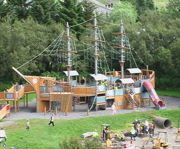
2 - 2 - or remain as passive areas; for example, ravine or linear park. The standard for neighbourhood parks is currently set at 0.6 ha (1.5 acres) per 1,000 residents. Under the existing Parks, Recreation and Culture Policy P-2 (3), the minimum size for a neighbourhood park is set at 1.6 ha (4 acres) and when added to an elementary school, the total site is to have a minimum size of 4.5 ha (11 acres). The neighbourhood park ratio of 0.6 ha (1.5 acres)/1000 residents is the standard in the Official Community Plan. The City has 129 small parks (<0.5 ha [1.25 acres]). Many are known as tot-lots, and are located primarily in older single-family residential neighbourhoods. These tot-lots tend to have narrow openings to the fronting street, have side or back yard fences bordering them, and often contain a small playground. Unfortunately, the location, surrounded by low-density development and developmentinterface design of many of these tot-lots has resulted in limited public use. New mini-parks (parkettes) have been constructed in the East Clayton neighbourhood. The design for these parkettes includes significant road frontage and development facing onto the park, thus permitting better surveillance of the parks by residents, visitors, by-law officers and police. With these design elements the city is anticipating increased use, safer environments for residents, and less inappropriate evening and nighttime use of the parks. Appendix A contains an example of a mini-park recently approved by Council. Impact of Growth and Changing Densities During the period of the PRC Master Plan, Surrey s population grew from approximately 286,000 residents to over 400,000. It is anticipated that growth in Surrey in the next ten years will result in a population of over 500,000. Recent residential development in the City has seen a far greater emphasis on multi-family residential development and single family small-lot and coach house residential neighbourhoods with much higher densities than ten years ago. In the new higher density neighbourhoods, the private outdoor space provided offers more limited opportunities for informal active play or community gatherings in comparison to the larger residential lots that were more typical 10 years ago. Because of this shift in available space on private grounds, the consultants leading the development of the new Parks, Recreation and Culture 10-Year ( ) Strategic Plan identified the need for smaller parks in high density areas to meet needs associated with early childhood development, to provide public space where residents can find temporary solitude and to provide small aesthetically pleasing civic meeting places for the local community. The consultant s findings mirrored the current staff perspective on the need for small parks and small civic plazas in high-density neighbourhoods and the need to strategically locate these parks/plazas through comprehensive park planning. In the draft PRC Strategic Plan, the consultant has suggested a maximum of 400 m distance between any residence and the nearest park; i.e., approximately a 10 minute walk. The consultant has also suggested that the existing Park categories of Neighbourhood, Community, City and Nature Preserve & Linkages be further divided to provide a finer typology of neighbourhood parks that meet more specific needs in communities undergoing transition from rural to suburban or suburban to urban. These further subcategories of Neighbourhood Parks would include Mini-park and Plaza as the smallest area sub-category under the Neighbourhood Park classification.
3 - 3 - DISCUSSION Mini-Park and Plaza Concept Neighbourhood Parks under the new park system planning would allow for mini-parks and plazas in high-density 1 areas, where there is currently not a local park within a 400m radius, or 10 minute walking distance that local residence or visitors can access. These new park classifications differ from the older Neighbourhood Park classification principally through their scale. They provide a mechanism for more comprehensively meeting local park amenity needs at the sub-neighbourhood level. The mini park / plaza concept, also differs from the older tot-lot model in relation to their design. The principal difference between a mini-park and a plaza is that the plaza will be largely hard landscaped (fountains, paving, art) and will be predominantly located in high traffic mixed use, business or commercial areas. Mini-parks are to be located in areas that are predominantly residential. They will incorporate much more greenery and will focus on local demographic amenity needs, such as playgrounds, ball courts, and sitting areas. Specific difference between Mini Park and Plaza Classifications 1. Plazas are civic open spaces in high-density urban mixed-use, commercial, business and service areas. The primary function of a plaza is to create a place for social interaction, where people can temporarily escape the hustle and bustle of a busy area. It is a local focal point, that may include public art, monuments, education pieces, or more traditional features such as fountains. Plazas will be a minimum of 150 square meters, and generally less than 2,500 square meters. Central features in a plaza are best appreciated and cared for by the local community when the feature is relevant to and chosen by the local community. The plaza will have strict design guidelines and siting criteria to ensure a sense of safety for users and appropriate use. It needs to be open and accessible to encourage use as a dynamic space and may integrate community design and or art with local uses and groups to ensure a local sense of ownership over the space. A plaza will function best when surrounded by animated human scale space, such as cafes, restaurant patios, and busy pedestrian corridors. Plazas in Surrey will differ from traditional larger European plazas by their smaller size and local use, as opposed to a focus on large markets or cathedrals, as was traditionally associated with the classic plaza. Plazas should be open to the street on 2 to 4 sides. In some instances, windows from busy retail or commercial facilities could replace street frontage, thus ensuring eyes on the plaza for safety and security. (See Appendix B includes some photo examples of mini-plazas) 1 High density is defined using Census Canada information, which for the 2006 data, is approximately 5, people per km2 in Surrey, which equals people an acre, or people per hectare.
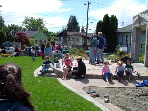
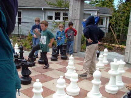
4 Mini-Parks are open spaces in high-density residential areas. Their primary function is to ensure basic local park amenities that compensate for the lack of private open spaces that would be found in the large backyards of lower density (larger lot) residential neighbourhoods. Mini-parks should not be smaller than 285 square meters (0.7 acres) and not larger than 1.2 hectares (3 acres). The mini-park creates a local green open space that facilitates the placement of neighbourhood park amenities within easy walking distance from nearby homes. The target patrons for a mini-park are families or clusters of specific amenity user groups, such as seniors. A mini-park should be located such that it has houses facing onto it and be surrounded by streets on 2 to 4 sides to ensure the safety of users and appropriate use. Special design consideration will be applied to mini-parks that exhibit important ecological values and are connected to a larger, continuous natural corridor. Considerations For Siting and Design of Mini-Parks And Plazas The following siting and design guidelines will be applied to mini parks and mini-plazas: Ensure clear sightlines across the entire site. The mini park / plaza must be open to the street on 2 to 4 sides. Buildings adjacent to or integrated into the park must be front facing, with walkways joining into the park and active rooms in adjacent buildings should face onto the park. Cafes or businesses interfacing with the mini-plaza should open onto the mini-plaza. Plazas should be oriented to be easily accessible to public transportation and should not interface with parking lots. The design of the mini-park or plaza must reflect human scale, as should adjacent development. Lighting may be included to increase visibility in the winter and to deter negative use during evening and nighttime hours. The local community will be engaged in the design process, both for built form and for artistic enhancement, reflecting the requirements of the City s public art policies. Criteria for Siting Mini-Parks Mini-parks will be developed in higher density residential areas with high numbers of families with children up to 14 years old or the potential for such a demographic mix. Subject to the immediately preceding criterion, mini-parks should be located within a 400m walking distance of all residences in their service area. Where possible, mini-parks should include some emphasis on natural landscapes with which children can interact as a means to gain a better understanding of and appreciation for nature. A mini-park may feature a unique environmental niche or rare ecosystem needing protection, and could be connected to a larger natural system, corridor or node via a liner park or riparian setback area.
5 - 5 - Costs Associated with Mini-parks and Plazas Based on experience with development of Parkette # 4 in East Clayton, which will be one of the first mini-parks in the City, a one-acre mini-park will cost approximately $55/sq. m. to develop, or approximately $250,000 per mini-park. This cost allows for basic landscaping and simple amenities such as park benches and basic playground equipment. The cost for plazas exceeds that of mini-parks, due to the extra costs associated with hard landscaping elements, averaging approximately $95/sq. m. or $400,000 per mini-plaza based on a 0.4 ha (1.0 acre) plaza. Extra features such as fountains would add to these costs. The unit costs for maintenance and operation of mini-parks will be greater than for larger parks, due to the lack of economies of scale and due to relatively high levels of public use. Implementation The Planning and Development Department and the Parks, Recreation and Culture Department have developed a tool for analyzing areas where mini-parks or plazas are required. This tool is essentially a gap analysis based on density maps of the City. The tool will be applied in Neighbourhood Concept Plan areas and in other re-developing areas of the City where density is currently increasing, or where density is expected to increase due to changes in zoning. This tool has already been used in preparing support materials for the new City Centre Plan. In the study area, preliminary analysis shows the need for two mini-parks and an additional plaza in the City Centre area. Once neighbourhoods have been identified as meeting the criteria for the development of mini-parks or plazas, land acquisition for the sites will be undertaken in accordance with the plans laid out in the Parkland Acquistion Program. Development of these mini-parks and plazas would then be prioritized in accordance with funding made available for such purposes in the Park Development Capital Program, in accordance with the Five-year Financial Plan. Other Considerations Mini-parks/plazas could also, in part, be acquired through the 5% parkland dedication on large subdivisions, as permitted under Section 941 (1) of the Local Government Act. Alternatively, these sites could be part of the outdoor amenity space in multi-family residential developments, where public access would be guaranteed through registration of appropriate right-of-ways. Developers under City-approved design guidelines and construction standards could construct cityowned mini-parks and plazas. A separate report is being prepared for Council consideration that will provide a process to allow developers to construct mini-parks, plazas and neighbourhood parks on behalf of the City during the land development process.
6 - 6 - SUMMARY Mini-park and Plaza are proposed new sub-categories of the Neighbourhood Park classification that will assist in addressing the needs of residents living in higher density areas of the City. It is recommended that Council approve Mini-Park and Plaza, as defined in this report, as subcategories of the Neighbourhood Park classification for use in high-density areas of the City and that Council approve the siting and design criteria for these park and plaza subcategories as articulated in this report. Jean Lamontagne General Manager, Planning and Development Laurie Cavan General Manager, Parks, Recreation and Culture CSP/OCC Attachments j:\park-rec\wpcentre\corprpts\2008\mini park-plaza corporate report june doc DCV 7/15/10 4:04 PM
7 Appendix A Example of a Mini-Park: East Clayton Parkette No. 4


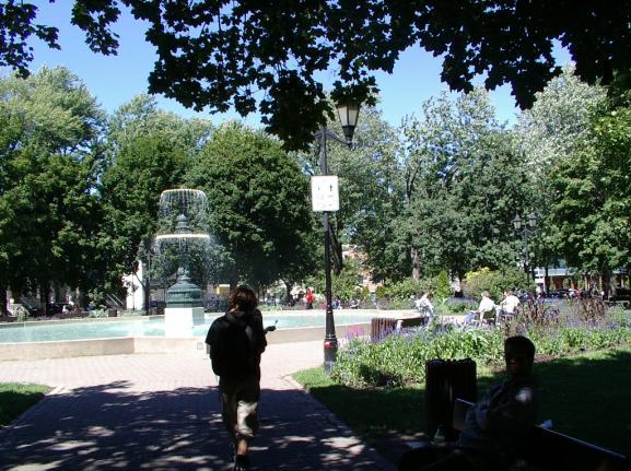
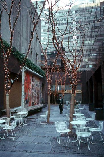

8 Appendix B Mini Park Examples Mini Plaza Examples
North Oakville East Parks Facilities Distribution Plan. November, 2009
 North Oakville East November, 2009 POLICY CONTEXT 1) Purpose a) The purpose of this document is to be a guide for the location, configuration, design and development of the parks system for the North Oakville
Nelson Residential Street Frontage Guideline
 DRAFT 22-06-2012 Nelson Residential Street Frontage Guideline June 2012 1317273 Contents and purpose Residential s are important Residential s are much more than corridors which move traffic. Streets allow
LOW DENSITY RESIDENTIAL
 LOW DENSITY RESIDENTIAL Corner lots with coach houses to increase diversity, provide unity to the streetscape and increase eyes on the street. Garages and ancillary units accessed via rear lanes. Parking
Westwind Developments Ltd. PIONEER LANDS AREA STRUCTURE PLAN - PROPOSED AMENDMENT
 FEBRUARY 2013 TABLE OF CONTENTS 1.0 BACKGROUND... 1 1.1 Amendment... 1 2.0 LOCATION & CONTEXT... 2 2.1 Land Ownership... 2 3.0 POLICY CONTEXT... 3 3.1 Municipal Development Plan... 3 3.2 Capital Region
4.1.3 LAND USE CATEGORIES
 4.1.3 LAND USE CATEGORIES a. City Center District The City Center District incorporates the existing character and mix of uses in downtown Belmont to encourage redevelopment and new development in keeping
TO: Mayor & Council DATE: April 12, The Planning and Development Department and the Engineering Department recommend that Council:
 CORPORATE REPORT NO: R080 COUNCIL DATE: April 12, 2010 REGULAR COUNCIL TO: Mayor & Council DATE: April 12, 2010 FROM: SUBJECT: General Manager, Planning and Development General Manager, Engineering Neighbourhood
Additional information about land use types is given in Chapter 5. Design guidelines for Centers and Neighborhoods are given in Chapter 7.
 4. Place Types Introduction In Albemarle County s Development Areas, the Neighborhood is the fundamental unit of community planning. The County s Neighborhood Model, an adopted part of the Comprehensive
Land Use Amendment in Southwood (Ward 11) at and Elbow Drive SW, LOC
 at and Elbow Drive SW, LOC") 2018 November 15 Page 1 of 10 EXECUTIVE SUMMARY This land use amendment application was submitted by Rick Balbi Architect on 2017 August 31 on behalf of Sable Developments Ltd, and with authorization from
2018 November 15 Page 1 of 10 EXECUTIVE SUMMARY This land use amendment application was submitted by Rick Balbi Architect on 2017 August 31 on behalf of Sable Developments Ltd, and with authorization from
1.4 TRANSIT VISION 2040 FROM VISION TO ACTION THEME 1: PUTTING TRANSIT AT THE CENTRE OF COMMUNITIES. Fully integrate transit with community design
 TRANSIT VISION 2040 FROM VISION TO ACTION TRANSIT VISION 2040 defines a future in which public transit maximizes its contribution to quality of life with benefits that support a vibrant and equitable society,
5.1 Site Plan Guidelines
 5. Community Core Guidelines Development of the Community Core will take place by plan of subdivision and site plan approval. It will occur in a phased manner that will reflect the timing of residential
10.0 Open Space and Public Realm
 10.0 Open Space and Public Realm 10.0 Open Space and Public Realm The Public Open Space System is comprised of: outdoor spaces available for public use that are either publicly owned (e.g., parks and
1.0 Purpose of a Secondary Plan for the Masonville Transit Village
 Report to Planning and Environment Committee To: Chair and Members Planning & Environment Committee From: John M. Fleming Managing Director, Planning and City Planner Subject: Masonville Transit Village
CITY CLERK. Parkland Acquisition Strategic Directions Report (All Wards)
") CITY CLERK Clause embodied in Report No. 10 of the, as adopted by the Council of the City of Toronto at its meeting held on November 6, 7 and 8, 2001. 10 Parkland Acquisition Strategic Directions Report
CITY CLERK Clause embodied in Report No. 10 of the, as adopted by the Council of the City of Toronto at its meeting held on November 6, 7 and 8, 2001. 10 Parkland Acquisition Strategic Directions Report
Rezoning. Rezone from C-4 and RA to RF-9C and RF-12C to allow subdivision into approximately 47 small single family lots in East Clayton.
 City of Surrey PLANNING & DEVELOPMENT REPORT File: 7903-0275-00 Rezoning Proposal: Rezone from C-4 and RA to RF-9C and RF-12C to allow subdivision into approximately 47 small single family lots in East
SECTION 4 OPEN SPACE ELEMENT
 Open Space Element SECTION 4 OPEN SPACE ELEMENT c 4.1 INTRODUCTION 4.1.1 SCOPE OF ELEMENT The state requires every general plan to have an open space element Section 65302{e». The open space element must
Comprehensive Plan ADOPTED APRIL 2014
 Comprehensive Plan ADOPTED APRIL 2014 8 8. Outstanding Recreational & Cultural Opportunities We are proud of our community s parks and recreation system. Our community will ensure that the legacy of our
Bourne Downtown Site Planning
 Prepared for: The Town of Bourne, MA In Cooperation with: Bourne Financial Development Corporation Prepared by:, Inc. June 24, 2009 Table of Contents Introduction and Summary... 1 Site Existing Conditions...
Complete Neighbourhood Guidelines Review Tool
 Complete Neighbourhood Guidelines Review Tool Prepared By: City of Regina Planning Department October 2014 Page 1 of 14 Community Development Review Checklist for Secondary Plans and Concept Plans The
City of Heath. Town Center Concept
 In the give-and-take of getting projects designed, financed, and approved, the famous refrain from the film Field of Dreams is heard often: if you build it, they will come. From the perspective of the
Chapter 13 Residential Areas: Appendices APPENDIX 1 Residential Areas
 Chapter 13 Residential Areas: Appendices Page 1 Chapter 13 Residential Areas: Appendices APPENDIX 1 Residential Areas Design Code for Intensive Housing INTRODUCTION DESIGN ELEMENTS A NEIGHBOURHOOD DESIGN
Community Design Guidelines. Port Wallace DRAFT
 Community Design Guidelines Port Wallace DRAFT Energy 1 2 3 Nature Movement Connections Built Form DRAFT Layout Energy 1 Nature Community Design Guidelines GREAT COMMUNITIES PROTECT, CELEBRATE, AND CONSERVE
Town of Portola Valley General Plan. Nathhorst Triangle Area Plan
 Town of Portola Valley General Plan Amended December 10, 1997 Table of Contents Introduction... 1 Planning Area... 1 Objectives... 2 Principles... 2 Standards... 4 Description... 4 Community Commercial...
Design Specifications & Requirements Manual
 11 PARKS & OPEN SPACES 11.1 DEFINITIONS... 1 11.1.1 Neighbourhood Parks... 1 11.1.2 District Parks... 1 11.1.3. Sport Parks... 1 11.1.4 Urban Parks... 1 11.1.5 Civic Spaces... 1 11.1.6 Open Space System...
THE GARDEN CITY PLAN. City of St. Catharines Official Plan. City of St. Catharines
 THE GARDEN CITY PLAN City of St. Catharines Official Plan City of St. Catharines August 2010 APPROVAL INFORMATION This Official Plan of the City of St. Catharines Planning Area, known as the Garden City
City of Langford Green Development Checklist
 City of Langford Green Development Checklist The following Green Development Checklist creates a sustainability standard for all comprehensive development within the City of Langford. The commitments made
Appendix H: Easement cross sections
 Appendix H: Easement cross sections SHARED PATH 1.5m FOOTPATH NATURE STRIP 7.3m CARRIAGEWAY 2.7m NATURE STRIP EXISTING PIPELINE 150mm DIA 5.0m (approx.) LOCAL ACCESS ROAD EXISTING PIPELINE 500mm DIA 2.7m
PUBLIC RIGHT-OF-WAY IN THIS CHAPTER PUBLIC REALM
 PUBLIC RIGHT-OF-WAY This section provides design guidelines for improvements in the public right-of-way. The public right-of-way refers to streets, sidewalks, non-vehicular thoroughfares, parks and greenways
appendix and street interface guidelines
 appendix five: building and street interface guidelines appendix 5 building and street interface guidelines BOULEVARDS Boulevards are generally characterized by higher levels of traffic movement at higher
URBAN DESIGN BRIEF URBAN DESIGN BRIEF 721 FRANKLIN BLVD, CAMBRIDGE August 2018
 URBAN DESIGN BRIEF URBAN DESIGN BRIEF 721 FRANKLIN BLVD, CAMBRIDGE August 2018 DESIGN BRIEF CONTENTS PART A 1.0 INTRODUCTION 2.0 DESCRIPTION & ANALYSIS OF SITE CONTEXT 3.0 DESIGN CONSTRAINTS AND OPPORTUNITIES
Executive Summary.. 1. Introduction
 Executive Summary.. 1. Introduction 1.1. Park and Open Space Development... 1 1.2. Park and Open Space Designations and Zones.... 2 1.3. Types of Parks... 2 1.4. Types of Open Spaces... 3 1.5. Who Should
Mix of Uses Guide for Transit-Oriented Development MIX OF USES
 MIX OF USES Creating a Destination Magnet A diversity of uses such as retail, housing, offices, civic and entertainment within the TOD creates a destination magnet for transit users and TOD neighbors.
Moody Centre Station TOD Area Today
 Moody Centre Station TOD Area Today WHAT IS a transit-oriented Murray Street development area? A Transit-Oriented Development (TOD) Area is a dense, walkable residential and commercial area built to support
PARK DEVELOPMENT MANUAL. 2 nd EDITION
 PARK DEVELOPMENT MANUAL 2 nd EDITION AUGUST 2017 CONTENTS PARK DEVELOPMENT MANUAL - 2 ND EDITION 1.0 Introduction 1 1.1 EXECUTIVE SUMMARY 3 1.2 BACKGROUND AND STRUCTURE 5 1.3 HOW TO USE THIS MANUAL 7 2.0
STRATHEARN HEIGHTS APARTMENTS PARKLAND IMPACT ASSESSMENT
 STRATHEARN HEIGHTS APARTMENTS PARKLAND IMPACT ASSESSMENT This document is submitted with the DC2 Application to the City of Edmonton on behalf of Rockwell Investments Ltd. and Nearctic Development Corporation
Appendix E Section 4(f) Evaluation
 Evaluation") Appendix E Section 4(f) Evaluation Appendix E Draft Section 4(f) Evaluation E.1 Introduction This appendix addresses a federal regulation known as Section 4(f), which protects parks, recreation areas,
Appendix E Section 4(f) Evaluation Appendix E Draft Section 4(f) Evaluation E.1 Introduction This appendix addresses a federal regulation known as Section 4(f), which protects parks, recreation areas,
Design Specifications & Requirements Manual
 11 PARKS & OPEN SPACES 11.1 DEFINITIONS... 1 11.1.1 Neighbourhood Parks... 1 11.1.2 District Parks... 1 11.1.3. Sport Parks... 1 11.1.4 Urban Parks... 1 11.1.5 Civic Spaces... 1 11.1.6 Open Space System...
South th E ast Communit ity Centre (SECC)
") South East Community Centre (SECC) 1 New Park Design & Community Centre Update Thursday, February 8, 2018 Public Open House Thank you for attending this Open House! The town and the Consulting Team will
South East Community Centre (SECC) 1 New Park Design & Community Centre Update Thursday, February 8, 2018 Public Open House Thank you for attending this Open House! The town and the Consulting Team will
URBAN DESIGN BRIEF. 2136&2148 Trafalgar Road. Town of Oakville
 URBAN DESIGN BRIEF 2136&2148 Trafalgar Road Town of Oakville Prepared By: METROPOLITAN CONSULTING INC For 2500674 Ontario Inc November 2016 TABLE OF CONTENTS Page No. 1.0 Introduction/Description of Subject
Chapter Purpose and Intent. 7.2 Applicability. 7.3 General Provisions RECREATIONAL OPEN SPACE
 Chapter 7. RECREATIONAL OPEN SPACE 7.1 Purpose and Intent The intent of this Chapter is to provide for centrally located, unencumbered land as neighborhood recreational open space and not to permit the
CHAPTER 4 - LAND USE CLASSIFICATIONS
 CHAPTER 4 - LAND USE CLASSIFICATIONS Four new land use classification categories are established in the Gualala Town Plan: Gualala Village Mixed Use; Gualala Highway Mixed Use; Gualala Planned Development
6 PORT SYDNEY SETTLEMENT AREA
 Section 6 Port Sydney Page 61 6 PORT SYDNEY SETTLEMENT AREA 6.1 Basis and Principles Village of Port Sydney Waterfront Community Existing Services 6.1.1 Port Sydney is an historic settlement that has developed
Appendix D North Road/N. Leroy Street Subarea Plan
 North Road/N. Leroy Street Subarea Plan INTRODUCTION The City of Fenton Master Plan was updated in 1996 and included a subarea plan for the North Leroy Street area of the City. It was recognized at that
Section 4 BUILDING THE MASTER PLAN
 The Master Plan 33 Section 4 BUILDING THE MASTER PLAN Figure 4:1. A collaborative effort characterized the two design workshops sponsored by DISC to create hypothetical Master Plans for the Towers Property
ELMVALE ACRES SHOPPING CENTRE MASTER PLAN
 ELMVALE ACRES SHOPPING CENTRE MASTER PLAN Contents 1.0 INTRODUCTION... 2 2.0 LOCATION... 2 3.0 EXISTING CONTEXT... 2 4.0 VISION & GUIDING PRINCIPLES... 2 5.0 LAND USE AND BUILT FORM... 4 5.1 St. Laurent
AVONDALE ESTATES GREENSPACE AD-HOC COMMITTEE
 AVONDALE ESTATES GREENSPACE AD-HOC COMMITTEE INVENTORY AND RECOMMENDATIONS REPORT November 7, 2018 Our Mission Statement: To provide assistance and support, through professional expertise in matters of
2A District-wide Policies
 2A Introduction This Chapter contains policies which are relevant to subdivision, use and development activities occurring across all zones and areas of the District. The policies in this Chapter implement
Chapter 1 - General Design Guidelines CHAPTER 1 GENERAL DESIGN GUIDELINES
 CHAPTER 1 GENERAL DESIGN GUIDELINES 1.0 INTRODUCTION This Publication has been developed to provide current, uniform procedures and guidelines for the application and design of safe, convenient, efficient
Description of Preferred Alternative
 Chapter 2 Description of Preferred Alternative 2.1 Introduction This chapter of the programmatic Sammamish Town Center Sub-area Plan Final EIS provides a more detailed description of the Preferred Alternative
Urban Design Brief. 875 Wellington Road. Proposed One-Storey Fast Food Restaurant and Two-Storey Restaurant. Wellington Harlech Centre Inc.
 Urban Design Brief 875 Wellington Road Proposed One-Storey Fast Food Restaurant and Two-Storey Restaurant Wellington Harlech Centre Inc. Prepared By: (519) 433-7587 info@yorkdev.ca May 3 rd 2013 1 Table
[PLANNING RATIONALE] For Site Plan Control and Lifting of Holding Zone By-Law 101 Champagne Avenue. May 23, 2014
![[PLANNING RATIONALE] For Site Plan Control and Lifting of Holding Zone By-Law 101 Champagne Avenue. May 23, 2014](/thumbs/75/71599615.jpg "[PLANNING RATIONALE] For Site Plan Control and Lifting of Holding Zone By-Law 101 Champagne Avenue. May 23, 2014") [PLANNING RATIONALE] For Site Plan Control and Lifting of Holding Zone By-Law 101 Champagne Avenue May 23, 2014 Contents 1.0 Introduction... 2 2.0 Site Context... 2 2.1 Adjacent Uses... 2 Figure 1: Site
[PLANNING RATIONALE] For Site Plan Control and Lifting of Holding Zone By-Law 101 Champagne Avenue May 23, 2014 Contents 1.0 Introduction... 2 2.0 Site Context... 2 2.1 Adjacent Uses... 2 Figure 1: Site
Dwelling Units Max 12 dwelling units per acre/min 8 dwelling units per acre. Development Mix 80% non residential/20% residential
 13. OSTEEN LOCAL PLAN Background: The Osteen Local Plan area is located in southwest Volusia County along the SR 415 corridor between Lemon Bluff Road and Acorn Lake Road and includes 3,990 acres. The
B L A C K D I A M O N D D E S I G N G U I D E L I N E S for Multi-family Development
 B L A C K D I A M O N D D E S I G N G U I D E L I N E S for Multi-family Development Adopted June 18, 2009 This section of the Design and focuses on site planning and design guidance for new multi-family
CONTENTS 8.0 LAND USE 8.1 GENERAL LAND USE 8.2 RESIDENTIAL 8.3 MIXED USE 8.4 COMMERCIAL 8.5 EMPLOYMENT LANDS
 8-2 Land Use 8.0 LAND USE CONTENTS 8.1 GENERAL LAND USE 8.1.1 Uses provided for in all Land Use Designations 8.1.2 Uses prohibited in Hazardous Lands, Hazardous Sites and Special Policy Areas 8.1.3 Uses
Staff Report to the North Ogden City Planning Commission
 Staff Report to the North Ogden City Planning Commission SYNOPSIS / APPLICATION INFORMATION Application Request: Concept review on a legislative application to rezone land located at approximately 1750
Subdivision Design Criteria. Penihana North GUIDELINES TO THE RULES
 Created September 2013 Penihana North Subdivision Design Criteria GUIDELINES TO THE RULES This part of the Plan sets out the design criteria for subdivision in Penihana North. The criteria will be considered
GREENBANK DEVELOPMENT MASTERPLAN
 DEVELOPMENT MASTERPLAN POTENTIAL TRAIN STATION COMMUNITY CENTRE Greenbank will be a connected masterplanned community providing easy access to local and surrounding amenity. Affordable quality homes, green
BYLAW C A Bylaw of Rocky View County to amend Land Use Bylaw C
 BYLAW C-7720-2017 A Bylaw of Rocky View County to amend Land Use Bylaw C-4841-97. The Council of Rocky View County enacts as follows: PART 1 TITLE This Bylaw shall be known as Bylaw C-7720-2017. PART 2
Policies and Code Intent Sections Related to Town Center
 Policies and Code Intent Sections Related to Town Center The Town Center Vision is scattered throughout the Comprehensive Plan, development code and the 1994 Town Center Plan. What follows are sections
East Bayshore Road Neighbourhood
 East Bayshore Road Neighbourhood Northridge Property Management Urban Design Brief 3195 East Bayshore Road City of Owen Sound January 2016 East Bayshore Road Neighbourhood Northridge Property Management
II. SINGLE FAMILY RESIDENTIAL
 II. SINGLE FAMILY RESIDENTIAL Castle Rock is made up of numerous individually built houses and subdivision tracts that have been developed during the past century. Some of the tracts are diverse in architectural
DEFINED VILLAGE CENTRES & NEIGHBOURHOODS
 DEFINED VILLAGE CENTRES & NEIGHBOURHOODS residents in Nanoose Bay support focusing attractive, planned future development in Red Gap Centre and the Area s neighbourhood centres. In addition, the development
DRAFT DRAFT DRAFT DRAFT
 # 19 EXPAND GREEN AND OPEN SPACES AND COMMUNITY FACILITIES IN TANDEM WITH NEW DEVELOPMENT The role of Eglinton will change in the coming years, along with the intensity of activity and land uses. As more
Highland Village Green Design Guidelines
 Highland Village Green Design Guidelines Publishing Information Title Highland Village Green Design Guidelins Author The City of Calgary Status DRAFT - Proposed document subject to changes Additional Copies
SECTION TWO: Overall Design Guidelines
 SECTION TWO: Overall Design Guidelines This section provides overall design principles and guidelines for the Gardnerville Mixed-use Overlay. They provide criteria for mixed-use places consisting of residential,
YONGE STEELES CORRIDOR SECONDARY PLAN. Young + Wright / IBI Group Architects Dillon Consulting Ltd. GHK International (Canada) Ltd.
 Ltd.") PART A: PREAMBLE 1.0 PURPOSE The purpose of this Secondary Plan is to provide a development framework for intensification of the Yonge/ Steeles corridor including the north side of Steeles Avenue West
PART A: PREAMBLE 1.0 PURPOSE The purpose of this Secondary Plan is to provide a development framework for intensification of the Yonge/ Steeles corridor including the north side of Steeles Avenue West
Commercial, Industrial & Institutional
 Official Community Plan Draft Policies Commercial, Industrial & Institutional I. COMMERCIAL/ COMMERCIAL MIXED-USE The commercial/commercial mixed-use areas are shown on the Land Use Designation Map. Encourage
Planning, Property and Development Department Report. To the Riel Community Committee
 Planning, Property and Development Department Report To the Riel Community Committee Date: October 30, 2006 File: SP 5/2006 Subject: Waverley West Northeast Neighbourhood Area Structure Plan Location:
6 RURAL RESIDENTIAL. 6.1 Rural Use. Rural Use (RU) Goals and Objectives. Policy Goal
 Goals and Objectives. Policy Goal") 6 RURAL RESIDENTIAL The vast majority of East Hants 466,426 acres are considered rural in nature and are characterized by a great diversity of uses. Because of this, land use policies in rural areas of
6 RURAL RESIDENTIAL The vast majority of East Hants 466,426 acres are considered rural in nature and are characterized by a great diversity of uses. Because of this, land use policies in rural areas of
City of Surrey PLANNING & DEVELOPMENT REPORT File:
 City of Surrey PLANNING & DEVELOPMENT REPORT PROPOSAL: Planning Report Date: September 14, 2009 OCP Amendment Temporary Industrial Use Permit in order to allow the outdoor storage of construction waste
Edward R. Sajecki Commissioner of Planning and Building. Land Use Review- Former Parkway Belt West Lands- Fieldgate Drive and Audubon Boulevard
 Corporate Report Clerk s Files Originator s Files CD.04.FOR DATE: November 15, 2011 TO: FROM: SUBJECT: Chair and Members of Planning and Development Committee Meeting Date: December 5, 2011 Edward R. Sajecki
Gateway commercial MIXED USE MASTER SITE PLAN. CITILAND AIrDRIE GATEWAY VENTURE INC. airdrie GATEWAY COMMERCE CENTRE. airdrie, ALBERTA FEBRUARY 2012
 Gateway commercial MIXED USE MASTER SITE PLAN 1914 CENTRE STREET NORTH CALGARY, AB CANADA T2E 2S8 T. 403.264.7177 F. 403.264-7175 WWW.CITILAND.CA CITILAND AIrDRIE GATEWAY VENTURE INC. airdrie GATEWAY COMMERCE
QUEEN-RIVER SECONDARY PLAN
 34 QUEEN-RIVER SECONDARY PLAN 34. QUEEN RIVER SECONDARY PLAN 1. INTRODUCTION The Queen-River area is approximately 6.4 hectares and is located at the eastern edge of the Downtown as shown on Map 34-1.
CHAPTER 7 I NDUSTRIAL
 CHAPTER 7 I NDUSTRIAL PURPOSE... 7:1 ORGANIZATION... 7:1 APPLICABILITY AND USE TYPES... 7:1 Light Industrial Development... 7:2 Heavy Industrial Development... 7:3 SITE DESIGN... 7:4 Circulation... 7:6
4.9 Mendocino Avenue Corridor Plan Design Guidelines
 4.9 Mendocino Avenue Corridor Plan Design Guidelines The Mendocino Avenue Corridor Plan addresses the area between College Avenue and Steele Lane. Mendocino Avenue is a busy arterial that runs parallel
The Village. Chapter 3. Mixed Use Development Plan SPECIFIC PLAN
 The Village SPECIFIC PLAN Chapter 3 3.1 INTRODUCTION 3.1.1 Purpose This Chapter describes the development regulations applicable to the Mixed-Use and Transit Center Planning Areas. These form-based regulations
THE CORPORATION OF THE TOWN OF OAKVILLE BY-LAW NUMBER
 THE CORPORATION OF THE TOWN OF OAKVILLE BY-LAW NUMBER 20012-08530 A by-law to adopt an amendment to the Official Plan of the Oakville Planning Area (Official Plan Amendment 198) Land North of Dundas Street.
11 GUIDING PRINCIPLES:
 11 GUIDING PRINCIPLES: CATEGORIES FIVE GUIDING PRINCIPLE CATEGORIES The Policy Statement will contain a set of Guiding Principles to inform the urban design and sustainability objectives for the site.
Applicant Name Phone / Fax / Address City State Zip Code . Property Owner Phone / Fax / Address City State Zip Code
 Master Development Plan Application Community Development Department City of Redmond 411 SW 9 th Street Redmond, Oregon 97756 541-923-7721 541-548-0706 FAX Master Development Plan Fee $38,862.52 File Number
S A C R A M E N T O C O U N T Y JACKSON HIGHWAY & GRANT LINE EAST VISIONING STUDY
 JACKSON HIGHWAY & GRANT LINE EAST S A C R A M E N T O C O U N T Y P L A N N I N G D E P A R T M E N T SUMMARY AND WORKBOOK November 19, 2008 History of the Visioning Study Sacramento County has two growth
This Review Is Divided Into Two Phases:
 Semiahmoo Town Centre Review The purpose of this review: To review the Semiahmoo Town Centre Concept Plan, originally approved in 1993, to ensure that this centre will continue to serve the needs of South
Throughout. square. (Crystal City Vision Plan 2050)
") 1: Terms related to the PSMP document 1 public space (see also public realm, civic space) An open space designated on the regulating plan, accessible to all, including Plazas, Mini Parks, and Neighborhoods
1: Terms related to the PSMP document 1 public space (see also public realm, civic space) An open space designated on the regulating plan, accessible to all, including Plazas, Mini Parks, and Neighborhoods
Urban Design Manual PLANNING AROUND RAPID TRANSIT STATIONS (PARTS) Introduction. Station Study Areas
 Introduction. Station Study Areas") 111111 PLANNING AROUND RAPID TRANSIT STATIONS (PARTS) Introduction The ION rapid transit system will link Waterloo, Kitchener and Cambridge through a central transit corridor (CTC). There are a number
111111 PLANNING AROUND RAPID TRANSIT STATIONS (PARTS) Introduction The ION rapid transit system will link Waterloo, Kitchener and Cambridge through a central transit corridor (CTC). There are a number
3. VISION AND GOALS. Vision Statement. Goals, Objectives and Policies
 Vision Statement Queen Creek s interconnected network of parks, trails, open spaces and recreation opportunities provide safe and diverse activities and programs that sustain its unique, small town, equestrian
Section 9 NEIGHBORHOOD DESIGN
 Section 9 NEIGHBORHOOD DESIGN City of Lancaster Comprehensive Plan D u n k i n, S e f k o & A s s o c i a t e s, I n c. NEIGHBORHOOD DESIGN INTRODUCTION There are many ways in which a neighborhood can
FORMER CANADIAN FORCES BASE (CFB) ROCKCLIFFE SECONDARY PLAN. Official Plan Amendment XX to the Official Plan for the City of Ottawa
 ROCKCLIFFE SECONDARY PLAN. Official Plan Amendment XX to the Official Plan for the City of Ottawa") FORMER CANADIAN FORCES BASE (CFB) ROCKCLIFFE SECONDARY PLAN Official Plan Amendment XX to the Official Plan for the City of Ottawa 1 INDEX THE STATEMENT OF COMPONENTS PART A THE PREAMBLE PAGE Purpose...
FORMER CANADIAN FORCES BASE (CFB) ROCKCLIFFE SECONDARY PLAN Official Plan Amendment XX to the Official Plan for the City of Ottawa 1 INDEX THE STATEMENT OF COMPONENTS PART A THE PREAMBLE PAGE Purpose...
Tel: (705) Fax: (705)
 Fax: (705)") 521 and 525 Essa Road City of Barrie Tel: (705) 812-3281 Fax: (705) 812-3438 Email: INFO@IPSCONSULTINGINC.com 1 5 0 D U N L O P S T R E E T E A S T, S U I T E 2 0 1, B A R R I E O N T A R I O L 4 M 1 B
521 and 525 Essa Road City of Barrie Tel: (705) 812-3281 Fax: (705) 812-3438 Email: INFO@IPSCONSULTINGINC.com 1 5 0 D U N L O P S T R E E T E A S T, S U I T E 2 0 1, B A R R I E O N T A R I O L 4 M 1 B
AGINCOURT SECONDARY PLAN
 1 AGINCOURT SECONDARY PLAN 1. AGINCOURT SECONDARY PLAN The following policies and principles apply to the area herein referred to as Agincourt, as outlined on Map 1-1. 1. GENERAL POLICIES 1.1 This Secondary
FROM: General Manager, Planning and Development FILE: (North Grandview Heights)
") Corporate NO: C009 Report COUNCIL DATE: May 18/05 COUNCIL-IN-COMMITTEE TO: Mayor & Council DATE: May 12, 2005 FROM: General Manager, Planning and Development FILE: 6520-20 (North Grandview Heights) SUBJECT:
Corporate NO: C009 Report COUNCIL DATE: May 18/05 COUNCIL-IN-COMMITTEE TO: Mayor & Council DATE: May 12, 2005 FROM: General Manager, Planning and Development FILE: 6520-20 (North Grandview Heights) SUBJECT:
Gold Line Bus Rapid Transit Transit Oriented Development (BRTOD) Helmo Station Area Plan
 Helmo Station Area Plan") Appendix F Gold Line Bus Rapid Transit Transit Oriented Development (BRTOD) Helmo Station Area Plan Introduction and Purpose of the Plan The Gold Line Bus Rapid Transit facility is an eleven-mile dedicated
Appendix F Gold Line Bus Rapid Transit Transit Oriented Development (BRTOD) Helmo Station Area Plan Introduction and Purpose of the Plan The Gold Line Bus Rapid Transit facility is an eleven-mile dedicated
C. Development Permit Area Guidelines
 Excerpt: The following is an excerpt from the City of Surrey s Official Community Plan Development Permit Area (DPA) Guidelines regarding the protection of agricultural lands pertinent to Section 919.1(c)
MIXED-USE VILLAGE OVERLAY FLOATING DISTRICT
 MIXED-USE VILLAGE OVERLAY FLOATING DISTRICT Zoning regulations developed by committee to the Planning Board for the Town of DeWitt, NY Issue date: 13 July 2017 revised 3/12/2018, revised 4/26/2018, 5/9/2018
Lambeth Main Street Streetscape Improvements
 Lambeth Main Street Streetscape Improvements Open House October 5th, 2017 Agenda 1. Introduction 2. Project Background 3. Context 4. Project Objectives 5. Design Principles & Approach 6. Streetscape Design
RECREATION AND OPEN SPACE ELEMENT GOALS, OBJECTIVES, AND POLICIES
 RECREATION AND OPEN SPACE ELEMENT GOALS, OBJECTIVES, AND POLICIES Goal 7 To provide park facilities, recreation programs, and open space resources that are safe, adequate, and accessible to all City residents,
1. Parks & Recreation Neighborhood Parks Community Parks Special Use Sites 2. Open Space 3. Trails
 Appendix A: Park Classifications The intent of parks and recreation classifications is to aid in making acquisition and design decisions for park sites, facilities and the organization of recreation space
Sierra Springs Regional Commercial Master Site Plan Airdrie, Alberta Hopewell Development Corporation Project No May 26, 2010
 Sierra Springs Regional Commercial Master Site Plan Airdrie, Alberta Hopewell Development Corporation Project No. 205-077 May 26, 2010 TABLE OF CONTENTS Purpose... 2 Master Site Plan Guidelines... 3 Overall
Leonard s Beach Secondary Plan (Alcona North) Official Plan Amendment
 Official Plan Amendment") Leonard s Beach Secondary Plan (Alcona North) Official Plan Amendment Public Meeting Presentation August 14, 2013 Note: This document is for presentation purposes only. Please see Staff Report DSR-135-13
Leonard s Beach Secondary Plan (Alcona North) Official Plan Amendment Public Meeting Presentation August 14, 2013 Note: This document is for presentation purposes only. Please see Staff Report DSR-135-13
3.1 community vision. 3.3 required plan elements
 Chapter 3 Community Form 3.1 community vision 3.2 Parks & landscaping concepts 3.3 required plan elements D R A F T 20 Community Form Chapter 3 3.0 Community form 3.1 community vision The Specific Plan
Parks Renaissance. Strategy. Director, Operations. General Committee. Presentation to. May 16, Barb Rabicki
 1 Parks Renaissance Strategy Presentation to General Committee May 16, 2016 Barb Rabicki Director, Operations Incorporates recommendation to complete Parks Renaissance Strategy Feedback / requests from
(DC1) Direct Development Control Provision DC1 Area 4
 Direct Development Control Provision DC1 Area 4") . General Purpose (DC) Direct Development Control Provision DC Area 4 The purpose of this Provision is to provide for an area of commercial office employment and residential development in support of the
. General Purpose (DC) Direct Development Control Provision DC Area 4 The purpose of this Provision is to provide for an area of commercial office employment and residential development in support of the
Neighborhood Districts
 NEIGHBORHOOD DISTRICTS SEVEN MAIN DISTRICTS Neighborhood Districts While the Development Plan provides a broad-scale overview of the neighborhood, this section focuses on uses and relationships at the