SAN MARTIN BOULEVARD OVER RIVIERA BAY PROJECT DEVELOPMENT & ENVIRONMENT (PD&E) STUDY
|
|
|
- Eunice Mason
- 6 years ago
- Views:
Transcription


")

1 KICK-OFF PRESENTATION SAN MARTIN BOULEVARD OVER RIVIERA BAY PROJECT DEVELOPMENT & ENVIRONMENT (PD&E) STUDY PROJECT IDENTIFICATION NUMBER (PID): #001036A May 13,

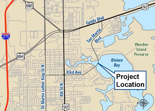
2 2 PROJECT LOCATION


3 PROJECT HISTORY 2012 Bridge Replacement Study 2013 Trail Alignment Study 2001 Gandy Blvd. Causeway Enhancements 2003 City Trails Program North Bay Trail Extension #19 Priority on MPO TA Program Bridge Replacement CIP 1036A Construction Funding 2018/19 3

 Determine Bridge Configuration for Trail Identify Safe Crossing Locations Develop Environmental Documentation Necessary")
4 PROJECT OBJECTIVES Address the bridge deficiencies Built in 1962 (52 years old) Sufficiency Rating = 66.7/100 Functionally Obsolete w/ Unknown Foundations Provide trail and pedestrian features consistent with the City s Trails Program & 2040 LRTP Provide Connection from North Bay Trail (Macoma Dr.) to Friendship Trail (Gandy Blvd.) Determine Bridge Configuration for Trail Identify Safe Crossing Locations Develop Environmental Documentation Necessary to Maintain Funding Opportunities 4
 requirements Follow the Minor Categorical Exclusion (MiCE) process per FDOT PD&E Manual Potential to")
5 PROJECT LIMITS & SCOPE Project Approach: Document as PD&E for Bridge Replacement with a trail enhancement component add-on Simplify level of documentation Address different funding sources San Martin Blvd. over Riviera Bay Bridge Replacement PD&E Meet National Environmental Policy Act (NEPA) requirements Follow the Minor Categorical Exclusion (MiCE) process per FDOT PD&E Manual Potential to become Type 2 Categorical Exclusion Evaluate Alternatives: No Build Rehabilitate Replacement North Bay Trail Extension Evaluation 5 Evaluate Alignment Alternatives Evaluate Crossing Locations
6 PD&E APPROACH Environmental / Engineering Data Collection Alternatives Development Alternatives Analysis and Evaluation Select Recommended Alternative Alternatives Public Meeting with Stakeholders Development of Technical Documents Public Hearing (Optional) Finalize NEPA Documents Location and Design Concept Approval 6

7 PUBLIC INVOLVEMENT 7 Stakeholders Pinellas County Government City of St. Petersburg Neighborhood Associations Riviera Bay Civic Association Riviera Bay Subdivision Homeowners Association Renaissance Neighborhood Association Residents Boaters Weedon Island Organized Recreational Users Duke Energy Florida Department of Transportation Tampa Bay Estuary Program Documentation Agencies Federal Highway Administration US Army Corps of Engineers United States Coast Guard Southwest Florida Water Management District


8 PUBLIC INVOLVEMENT OUTREACH Proactive interaction with stakeholders Project specific Public Involvement Program Alternatives workshop Outreach through community media sources Project website San Martin Boulevard Project Development and Environment Study 8
 (Public Use Facilities) Weedon Island Preserve Tampa Bay Outstanding Florida")
9 KEY ISSUES 9 Community Considerations Community Cohesion Right-of-Way Relocation Potential Archaeological and Historical Sites Bridge lacks distinction therefore it s not considered historic Channel Navigation Needs During Construction Environmental Considerations Wetlands Protected Species / Habitat Section 4 (f) (Public Use Facilities) Weedon Island Preserve Tampa Bay Outstanding Florida Waters Physical Environmental Air or water quality impacts Noise (Traffic & Construction) Contamination or hazardous materials involvement
10 KEY ISSUE - ALTERNATIVES EVALUATION Meet requirements of NEPA Process Maintain integrity of NEPA process by documenting evaluation of low, mid and high level profiles Document benefits, costs and impacts of each horizontal alignment and vertical alignment evaluated Balance Stakeholder desires with impacts Evaluate feasible alignment alternatives such as highest constrained profile Clearly address benefits of low impact alternatives with respect to constructability Clearly present Alternatives to Public Develop preliminary analysis and meet with County staff to evaluate alternatives to move forward to public involvement Support alternatives workshop meeting to solicit input 10


11 ALIGNMENT ALTERNATIVES Original, East & West Shifted Alignments Maintaining original alignment necessitates closing the road during construction Shifted alignments evaluated to maintain road open during construction 11
 Mid Level (± 45 ft. of clearance) Low Level (± 20 ft.")
 Constrained by adjacent intersections (Tallahassee")

12 PROFILE ALTERNATIVES High Level (± 70 ft. of clearance) Mid Level (± 45 ft. of clearance) Low Level (± 20 ft. of clearance) Highest Constrained (± 18 ft. of clearance) Constrained by adjacent intersections (Tallahassee Drive and Weedon Drive) Maintaining traffic on bridge during construction impacts clearance attainable Movable Option Evaluated for Cost Comparison Existing Clearance = ± 10 ft. 12

13 NORTH BAY TRAIL EXTENSION EVALUATION OBJECTIVES Determine Best Trail Configuration Provide connectivity to adjacent trails & Weedon Island Preserve Minimize environmental impacts Evaluate Safe Locations for Trail Crossings North Bay Trail Existing Terminus Weedon Island/Duke Energy Trail Savora Dr. Trail Gandy Blvd. Friendship Trail 13

14 NORTH BAY TRAIL EXTENSION EVALUATION TYPICAL SECTIONS Macoma Drive to Weedon Island Drive Curb and Gutter Roadway with Trail on West/North due to R/W constraints Minimal Environmental Impacts Maintain existing pavement while adding trail and sidewalk 14 Design Speed = 40 MPH

15 NORTH BAY TRAIL EXTENSION EVALUATION TYPICAL SECTIONS Weedon Island Drive to Gandy Blvd. Rural Roadway with Unpaved Shoulders Trail Location Affected by Environmental Constraints and Connectivity Add paved shoulders, trail and sidewalk 15
16 SCHEDULE TASK D J-M A-J J-S O-D J-M A-J J-S O-D J-M Receive Survey Data from County Public Involvement Alternatives Workshop Public Hearing (Optional Service) Engineering Data Collection Engineering Analysis/Documents Environmental Data Collection/ Analysis/Reports Prepare Environmental Document Submit Final Docs to FDOT for FHWA FHWA Review/Issue LDCA FHWA Review/Issue LDCA 16 Construction programmed in County CIP for 2018/2019 Schedule contingent on acquisition of 50% grant funding. Actual construction time frame will be dependent on acquisition, timing and amount of available grant funding.
17 QUESTION & ANSWER CONTACT INFORMATION Pinellas County Project Manager Nancy McKibben, MPA
18
Beckett Bridge PD& E Study. Presentation to: Board of County Commissioners
 Beckett Bridge PD& E Study Presentation to: Board of County Commissioners October 22, 2013 Introduction Study Began January 2012 Alternatives Presented to Commission October 2013 Alternatives Presented
Public Hearing. Charlotte County-Punta Gorda MPO - Meeting Rooms A and B March 14, open house at 4 p.m., formal presentation at 5 p.m.
 Public Hearing Charlotte County-Punta Gorda MPO - Meeting Rooms A and B March 14, 2019 open house at 4 p.m., formal presentation at 5 p.m. Welcome to the Public Hearing for the Harborview Road (CR 776)
PD&E STUDY SR 9/I-95 FROM SOUTH OF SR 870/COMMERCIAL BOULEVARD TO NORTH OF CYPRESS CREEK ROAD FM # ETDM 14222
 PD&E STUDY SR 870/COMMERCIAL BOULEVARD TO NORTH OF CYPRESS CREEK ROAD FM # 435808-1-22-02 ETDM 14222 WELCOME TO THE KICK-OFF MEETING May 24, 2016 1 1 2 3 4 5 6 PLANNING PROJECT DEVELOPMENT AND ENVIRONMENT
Kick-off Meeting. FM No: ETDM No: 14050
 Kick-off Meeting FM No: 433511-1-22-01 ETDM No: 14050 June 26, 2014 FM No. 433511 1 22 01 Project Location 2 Project Purpose and Need Improve traffic operations and safety conditions at the intersections
Boca Raton II Tri-Rail Station PD&E Study and 30% Documents Public Kick-Off Meeting. August 29, 2017 Spanish River Library
 Boca Raton II Tri-Rail Station PD&E Study and 30% Documents Public Kick-Off Meeting August 29, 2017 Spanish River Library Introductions 2 Partner Stakeholder Agencies FDOT District Four Palm Beach Metropolitan
I-95 Interchange & Ellis Road PD&E Study
 I-95 Interchange & Ellis Road PD&E Study Brevard County, Florida Presentation to the Space Coast TPO October 14, 2010 The Project Provide a New Interchange with I-95 Using the Ellis Road Corridor, Extend
PUBLIC HEARING. Thursday, December 14, 2017 FDOT Urban Office 2198 Edison Avenue Jacksonville, FL 32204
 DISTRICT TWO PUBLIC HEARING I 10 (SR 8) from I 295 to I 95 Project Development & Environment Study Duval County, Florida Financial Project Number 213326 2 22 01 Efficient Transportation Decision Making
Panama City Beach Community Redevelopment Agency ON THE MOVE IN PCB
 Panama City Beach Community Redevelopment Agency ON THE MOVE IN PCB Program Goals, Activities and Accomplishments I. Beach Front Multi-modal Transportation, Aesthetic and Parking Improvements III. Connector
The Illinois Department of Transportation and Lake County Division of Transportation. Route 173, including the Millburn Bypass
 The Illinois Department of Transportation and Lake County Division of Transportation welcome you to this Public Hearing for U.S. Route 45 from Illinois Route 132 to Illinois Route 173, including the Millburn
Purpose of Tonight s Meeting
 Location Map 3 Purpose of Tonight s Meeting Explain to you the Alternatives considered Provide information about these Alternatives Engineering Environmental Present the Project Schedule Obtain your input
PROJECT BACKGROUND. Preliminary Design Scope and Tasks
 PROJECT BACKGROUND Preliminary Design Scope and Tasks The purpose of this Study is the development of preliminary designs for intersection improvements for Trunk Highway (TH) 36 at the intersections of
Welcome. South Seminole Heights Civic Association, Inc. Tampa Interstate Study Supplemental Environmental Impact Statement.
 Welcome South Seminole Heights Civic Association, Inc. October 17, 2018 Tampa Interstate Study Supplemental Environmental Impact Statement 1 Stephen Benson Opening FDOT District Seven 2 3 Our solutions
WELCOME! 8 8:30 6: TH STREET IMPROVEMENTS. Open House. Presentation & Q&A
 WELCOME! 168 TH STREET IMPROVEMENTS 6:30 Open House 7 8 Presentation & Q&A 8 8:30 Open House WELCOME Todd Pfitzer City of Omaha Engineer Bob Stubbe City of Omaha Public Works Director Jon Meyer Project
Community Workshop. City of Richmond. January 25, 2011 SF Bay Trail Connection - Castro St to Richmond-San Rafael Bridge
 Community Workshop City of Richmond 1 City of Richmond Lead Agency BPAC Richmond Community ABAG Design and Process Funding Partner Caltrans Environmental; Process Review Design Process State and Federal
ITS Concept Development Activity Descriptions
 ITS Concept Development Activity Descriptions October 2015 Procedures are subject to change without notice. Check the NJDOT website to ensure this is the current version. Table of Contents Concept Development
Pennsy Greenway Trail
 Town of Schererville Pennsy Greenway Trail DES. #s: 0401062, 1173595 & 1382661 Construction of Pennsy Greenway Trail beginning at Wilhelm Street and continuing northwest along the former Penn Central railroad
SECTION 4(f) DE MINIMIS DOCUMENTATION
 DE MINIMIS DOCUMENTATION") SECTION 4(f) DE MINIMIS DOCUMENTATION Illinois Route 60/83 IL 176 to the intersection of IL 60 (Townline Road) Lake County P-91-084-07 Mundelein Park and Recreation District Project Limit SECTION 4(f)
SECTION 4(f) DE MINIMIS DOCUMENTATION Illinois Route 60/83 IL 176 to the intersection of IL 60 (Townline Road) Lake County P-91-084-07 Mundelein Park and Recreation District Project Limit SECTION 4(f)
SR-2 Freeway Terminus Improvement Project
 SR-2 Freeway Terminus Improvement Project Welcome! Public Hearing, Mayberry Elementary June 16, 2009, 6:30 p.m. 8:30 p.m. Agenda 6:30 PM 6:50 PM Registration and Open House 6:50 PM 7:00 PM Welcome and
Howard Frankland Bridge Regional Transit Corridor Evaluation
 Howard Frankland Bridge Regional Transit Corridor Evaluation St Pete Planning & Vision Commission October 11, 2011 FPN: 422799 1 12 04 2 Project Website www.mytbi.com Click on Future Projects, then I-275
PREPARED FOR: PLATTEVIEW ROAD CORRIDOR STUDY EXECUTIVE SUMMARY
 PREPARED FOR: PLATTEVIEW ROAD CORRIDOR STUDY EXECUTIVE SUMMARY SEPTEMBER 2016 Introduction The Platteview Road Corridor Study was led by the Metropolitan Area Planning Agency (MAPA) with assistance from
2040 Long Range Transportation Plan
 2040 Long Range Transportation Plan Adopted: April 15, 2013 APPENDIX D HIGHWAY NEEDS PLAN PROJECTS FREDERICKSBURG Existing and Committed Projects Fall Hill Avenue/Mary Washington Blvd. (Fredericksburg)
Clay Street Bridge Replacement Project
 Clay Street Bridge Replacement Project Frequently Asked Questions (FAQs) No. 2 April 4, 2018 The project is located in downtown Placerville on Clay Street between US Highway 50 and Main Street and Cedar
HILLSBOROUGH COUNTY Greenways and Trails Plan Update. Executive Summary. Date
 HILLSBOROUGH COUNTY Greenways and Trails Plan Update Executive Summary Date PURPOSE AND PROJECT OVERVIEW The Hillsborough County Greenways Master Plan (1995) and the City of Tampa s Greenways and Trails
DuPage Mayors and Managers Conference June 21, 2013 TRANSPORTATION PROGRAM (STP) WORKSHOP
 WORKSHOP") DuPage Mayors and Managers Conference June 21, 2013 TRANSPORTATION PROGRAM (STP) WORKSHOP Lombard Village Hall Marilin Solomon, P.E. Field Engineer West Division (Central & North Central Cook County, DuPage
DuPage Mayors and Managers Conference June 21, 2013 TRANSPORTATION PROGRAM (STP) WORKSHOP Lombard Village Hall Marilin Solomon, P.E. Field Engineer West Division (Central & North Central Cook County, DuPage
West Dennis Center: Bass River to Old Main Street. West Dennis Business District: Old Main Street to Dennis Commons
 West Dennis Center: Bass River to Old Main Street West Dennis Business District: Old Main Street to Dennis Commons Dennisport Center: Dennis Commons to Division Street Main Street Project Goals Project
Interchange Justification Report (IJR) and PD&E for S.R. 8 C.R. 4 (Antioch Road) Interchange
 and PD&E for S.R. 8 C.R. 4 (Antioch Road) Interchange") Interchange Justification Report (IJR) and PD&E for S.R. 8 (I-10) @ C.R. 4 (Antioch Road) Interchange Presented by: Greg Moore, PE FDOT Project Study Team Project Overview 1. Interchange Justification
Interchange Justification Report (IJR) and PD&E for S.R. 8 (I-10) @ C.R. 4 (Antioch Road) Interchange Presented by: Greg Moore, PE FDOT Project Study Team Project Overview 1. Interchange Justification
Pinellas County Greenways
 Pinellas County Greenways USING GREENWAYS TO LINK OPEN SPACES The Florida Greenways Commission has defined a greenway as...a corridor of protected open space that is managed for conservation and/or recreation.
THREE-YEAR CAPITAL IMPROVEMENT PLAN FY
 THREE-YEAR CAPITAL IMPROVEMENT PLAN FY2016 2018 Annual CIP Development Process Public Works & Engineering Divisions Prepare List of Capital Needs and Recommended Deferred Maintenance Public Works & Engineering
Wiles Road from University Drive to Riverside Drive
 Wiles Road from University Drive to Riverside Drive Presented to: Broward County WSP Parsons Brinckerhoff is now Presented by: WSP USA Inc. Our Team.. Introduction / Project Team Cecilia Villoria, PE Project
SAN RAFAEL GENERAL PLAN 2040 INTRODUCTION AND OVERVIEW
 SAN RAFAEL GENERAL PLAN 2040 INTRODUCTION AND OVERVIEW Steering Committee Presentation February 14, 2018 Purpose of General Plan Guide land use and development decisions Coordinate transportation, infrastructure,
FDOT D4 Complete Streets
 FDOT D4 Complete Streets Context Sensitive Solutions Directs that complete street solutions will complement the context of the community. Collaborative approach to decision making, project development,
I-4 Poinciana Parkway Connector Project Development and Environment (PD&E) Study. OCX Board Meeting
 Study. OCX Board Meeting") I-4 Poinciana Parkway Connector Project Development and Environment (PD&E) Study Presentation for: OCX Board Meeting January 14, 2014 Financial Project ID: 433693-2-22-01 ETDM No.: 13957 - Poinciana Parkway
I-4 Poinciana Parkway Connector Project Development and Environment (PD&E) Study Presentation for: OCX Board Meeting January 14, 2014 Financial Project ID: 433693-2-22-01 ETDM No.: 13957 - Poinciana Parkway
TAC/CAC, TPO Project Update February 2016
 A1A MULTIMODAL CORRIDOR PLANNING AND ENGINEERING ANALYSIS Florida Department of Transportation TAC/CAC, TPO Update February 2016 PRESENTATION FOOTERT Meeting Agenda What We Plan To Discuss Background New
WELCOME CPT CORRIDOR AREA PROJECT BACKGROUND BROOKSIDE BLVD. The objectives of the CPT Functional Design Study included:
 1 WELCOME Welcome to the Public Information Session for the Functional Design Study of the Chief Peguis Trail Extension West from Main Street to Brookside Boulevard PROJECT BACKGROUND The objectives of
I. DESCRIPTION OF PROPOSED ACTION... 1 A. General Description... 1 B. Historical Resume and Project Status... 2 C. Cost Estimates...
 PROJECT COMMITMENTS SUMMARY... S-1 1. Type of Action... S-1 2. Description of Action... S-1 3. Summary of Purpose and Need... S-1 4. Alternatives Considered... S-2 5. NCDOT Alternatives Carried Forward...
Municipality of Anchorage. Community Council Survey Capital Projects Needs Ranking Survey (ALPHABETICAL) Airport Heights
 Airport Heights") ANCHORAGE PARKS & RECREATION Nichols Park Design and improve neighborhood park 2008 Challenge Grant applicant. 2008 $500K State Grant for Neighborhood Parks. Tikishla Park Lighting, paved parking, hockey
ANCHORAGE PARKS & RECREATION Nichols Park Design and improve neighborhood park 2008 Challenge Grant applicant. 2008 $500K State Grant for Neighborhood Parks. Tikishla Park Lighting, paved parking, hockey
State Project No Heroes Tunnel
 Public Scoping Meeting State Project No. 167-108 Bridge No. 00773 Heroes Tunnel Route 15 Wilbur Cross Parkway Through West Rock Ridge Towns of Hamden, Woodbridge City of New Haven Agenda Show Project Location
Construction Engineering & Inspection
 Construction Engineering & Inspection Serving Florida for 20 Years CEI Engineering Planning Landscape Architecture Urban Design Construction Engineering & Inspection (CEI) I N T R O D U C T I O N Over
ALTERNATIVES. NCDOT made an early decision to first determine how to build the project (construction method) followed by what to build (alternatives).
 followed by what to build (alternatives).") III. ALTERNATIVES A. CONSTRUCTION METHOD ALTERNATIVES NCDOT made an early decision to first determine how to build the project (construction method) followed by what to build (alternatives). One of the
III. ALTERNATIVES A. CONSTRUCTION METHOD ALTERNATIVES NCDOT made an early decision to first determine how to build the project (construction method) followed by what to build (alternatives). One of the
Pine Island Road Corridor Master Plan
 RECOMMENDED DEVELOPMENT PLAN Figure 9: Del Prado Village District Conceptual Framework The Conceptual Framework (Figure 8) for development of the Pine Island Corridor is to encourage mixed-use development
IOWA HIGHWAY 57 / WEST 1 ST STREET STUDY PUBLIC INFORMATIONAL MEETING APRIL 22, 2014
 IOWA HIGHWAY 57 / WEST 1 ST STREET STUDY PUBLIC INFORMATIONAL MEETING APRIL 22, 2014 INTRODUCTION The City of Cedar Falls and the Iowa Department of Transportation are conducting a Public Informational
GREEN SHEET ENVIRONMENTAL COMMITMENTS FOR THE IOWA HIGHWAY 100 EXTENSION
 County: Linn County, IA GREEN SHEET Location: IA 100, from its terminus at Edgewood Rd. to US 30 southwest of Cedar Rapids Route: IA 100 Extension Project No.: NHS-100-1(36) 19-57 OLE Project Managers:
Public Information/Cultural Resources Committee Workshop August 15, Florida Department of Transportation District One
 Public Information/Cultural Resources Committee Workshop August 15, 2012 Florida Department of Transportation District One SR 542 from 1 st Street to E. of Buckeye Loop Road Winter Haven, Polk County FPID#
PROJECT STATEMENT LOCATION/DESIGN PUBLIC HEARING. 19 th AVENUE NORTH EXTENSION PROJECT FROM SPRINGDALE DRIVE TO NORTH 2 ND STREET/U.S.
 PROJECT STATEMENT LOCATION/DESIGN PUBLIC HEARING 19 th AVENUE NORTH EXTENSION PROJECT FROM SPRINGDALE DRIVE TO NORTH 2 ND STREET/U.S. 67 HEARING LOCATION: ERICKSEN COMMUNITY CENTER 1401 11 TH AVENUE NORTH
Abbott Loop. Community Council Survey Capital Projects Needs Ranking Survey. Comm Council Priority Rank. Rank # ABBOTT LOOP COMMUNITY PARK
 Municipality of Anchorage Community Council Survey ABBOTT LOOP COMMUNITY PARK This state funding request would be used to implement the remaining elements of the Community Park Master Plan Vision including
The Vision. Photo provided by The Minervini Group. 46 Vision, Objectives & Strategies
 Vision, Objectives & Strategies The is the public framework and guide for future development of the Grand Traverse Commons. The establishes public polices for infrastructure, the preservation of natural
CENTERTON ROAD BRIDGE REPLACEMENT
 CENTERTON ROAD BRIDGE REPLACEMENT FEASIBILITY STUDY BURLINGTON COUNTY BRIDGE C4.4 OVER RANCOCAS CREEK TOWNSHIPS OF MOUNT LAUREL, WESTAMPTON & WILLINGBORO 1 prepared for: BOARD OF CHOSEN FREEHOLDERS BURLINGTON
MDX SR 836/DOLPHIN EXPRESSWAY SOUTHWEST EXTENSION
 MDX SR 836/DOLPHIN EXPRESSWAY SOUTHWEST EXTENSION Project Development and Environment (PD&E) STUDY Miami-Dade County, Florida Preliminary Executive Summary Alternative Corridor Evaluation (ACE) Report
Categorical Exclusion (CE) Determination Project Narrative
 Determination Project Narrative") Categorical Exclusion (CE) Determination Project Narrative Project Information Project Name: SUPERSTRUCTURE REPLACEMENT & SUBSTRUCTURE REHABILITATION, C-17-002, ATLANTIC AVENUE OVER LITTLE HARBOR INLET
Categorical Exclusion (CE) Determination Project Narrative Project Information Project Name: SUPERSTRUCTURE REPLACEMENT & SUBSTRUCTURE REHABILITATION, C-17-002, ATLANTIC AVENUE OVER LITTLE HARBOR INLET
I-90 Mississippi River Bridge & Interchange Project
 I-90 Mississippi River Bridge & Interchange Project Presentation Outline I. Background: Context & Need for Project II. Preferred Alternative Overview III. Project Development IV. Project Management Tools
Chapter 1 - General Design Guidelines CHAPTER 1 GENERAL DESIGN GUIDELINES
 CHAPTER 1 GENERAL DESIGN GUIDELINES 1.0 INTRODUCTION This Publication has been developed to provide current, uniform procedures and guidelines for the application and design of safe, convenient, efficient
AGENDA ITEM 3A Red Hills Coastal Parkway
 March 26, 2007 AGENDA ITEM 3A Red Hills Coastal Parkway REQUESTED BY: CRTPA Members TYPE OF ITEM: Discussion STATEMENT OF ISSUE At the January 22, 2006 Capital Region Transportation Planning Agency (CRTPA)
Poinciana Parkway Extension Project Development & Environment Study
 Poinciana Parkway Extension Project Development & Environment Study Nicole Gough, Dewberry Mary Brooks, Quest Corporation of America Clif Tate, Kimley-Horn and Associates February 19, 2019 Title VI Compliance
Public Meeting #3 May 9, 2009 MVVA Team
 Public Meeting #3 May 9, 2009 MVVA Team Welcome to the third Public Meeting for the Lower Don Lands Municipal Class Environmental Assessment (EA) Infrastructure Master Plan and Keating Channel Precinct
Purpose of Open House #3
 Public Meeting #3 May 9, 2009 MVVA Team Purpose of Open House #3 The main purpose of this Open House is to present and seek input on the: Evaluation of transportation and infrastructure design alternatives
Southern Gateway Project and Public Green
 Southern Gateway Project and Public Green Transportation and Trinity River Project Committee May 23, 2016 Purpose of Presentation Provide the history and an overview of the Southern Gateway Project (SGP)
HISTORIC PRESERVATION
 HISTORIC PRESERVATION City of St. Augustine Comprehensive Plan EAR-Based Amendments Historic Preservation Element HP Goal Maintain and enhance the historic integrity and ambiance within the City of St.
STATE OF TENNESSEE DEPARTMENT OF TRANSPORTATION ENVIRONMENTAL DIVISION
 STATE OF TENNESSEE DEPARTMENT OF TRANSPORTATION ENVIRONMENTAL DIVISION Suite 900 - James K. Polk Building 505 Deaderick Street Nashville, Tennessee 37243-0334 MEMORANDUM TO: FROM: Files Joe W. Matlock,
Congestion Management Safety Plan. Michael Corbett State Program Administrator September 2017
 Congestion Management Safety Plan Michael Corbett State Program Administrator September 2017 Agenda Topic 1 What is the Congestion Management Safety Plan (CMSP)? 2 Relevance to Congestion Investments 3
COLLIER BOULEVARD (CR 951) CORRIDOR
 CORRIDOR") Project(s) Goals Improve Traffic Circulation, Capacity & Safety Focus on Safety During Design & Construction Address Public Concerns Design an Aesthetically Pleasing Project Limit Environmental Impacts
Project(s) Goals Improve Traffic Circulation, Capacity & Safety Focus on Safety During Design & Construction Address Public Concerns Design an Aesthetically Pleasing Project Limit Environmental Impacts
NORTH-SOUTH CORRIDOR STUDY EXECUTIVE SUMMARY. Executive Summary
 Executive Summary Background As congestion continues to affect mobility in the region, the Ozarks Transportation Organization (OTO) is particularly concerned with traffic movement. The North-South Corridor
T H A T E V E R Y O N E
 B R I N G I N G C H A N G E T H A T E V E R Y O N E C A N F E E L. AT CHW, we survey, plan, design, engineer, administer and inspect with a purpose: to positively transform the communities we serve. From
Access Management and Site Plan Review. Robert W. Hofrichter Asst Administrator, Transportation and Mobility Planning Division April 2014
 Access Management and Site Plan Review Robert W. Hofrichter Asst Administrator, Transportation and Mobility Planning Division April 2014 Access Management 2 Access Management What is Access Management?
Places29: List of Implementation Projects
 Important Points to Keep in Mind When Using This List Places29: List of s Each of the projects in this List represents an action needed to implement the Places29 Master Plan. The projects are grouped first
2035 General Plan Update and Belmont Village Specific Plan. Joint Study Session with the City Council and Planning Commission April 12, 2016
 2035 General Plan Update and Belmont Village Specific Plan Joint Study with the City Council and Planning Commission April 12, 2016 Agenda 1. Welcome and Introductions 2. General Plan Update Status of
Public Meeting December 1 st, 2011
 San Francisco Bay Trail Connection Castro Street to Richmond-San Rafael Bridge Public Meeting December 1 st, 2011 Architecture & Engineering Report Agenda Introductions & Opening Remarks Project Purpose
SELMON GREENWAY FEASIBILITY STUDY. For: Hillsborough County Metropolitan Planning Organization By: Renaissance Planning
 SELMON GREENWAY FEASIBILITY STUDY For: Hillsborough County Metropolitan Planning Organization By: Renaissance Planning SELMON GREENWAY FEASIBILITY STUDY VISION Multimodal connection between Bayshore Blvd
ORDINANCE NO WHEREAS, the recommendations from the Pinellas County Local Planning Agency have been received and considered.
 ORDINANCE NO. 16-55 AN ORDINANCE OF THE COUNTY OF PINELLAS, AMENDING THE FUTURE LAND USE AND QUALITY COMMUNITIES ELEMENT OF THE PINELLAS COUNTY COMPREHENSIVE PLAN TO ADOPT THE CRYSTAL BEACH COMMUNITY OVERLAY;
Welcome to the 2018 FRPA Conference!
 Welcome to the 2018 FRPA Conference! Learning Objectives Describe the benefits of regional multipurpose trails Recall Florida s Priority Regional Trails and recognize their general locations across the
Overall Map. Chicago. St. Louis. Summit. Joliet. Dwight. Pontiac. Bloomington-Normal Lincoln. Springfield. Carlinville. Alton EXPERIENCE IT YOURSELF.
 Overall Map Summit Chicago Bloomington-Normal Lincoln New Station Planned New Station Planned Dwight Pontiac Joliet Pedestrian overpass and second platform planned Higher speed service began in this section
The Village of Sugar Grove, in partnership with Kane County, the Illinois Department of Transportation, and the Illinois Tollway welcomes you to the
 The Village of Sugar Grove, in partnership with Kane County, the Illinois Department of Transportation, and the Illinois Tollway welcomes you to the first Public Meeting for the proposed interchange improvement
1.0 INTRODUCTION 1.1 TH 14 WEST STUDY AREA Project Description Functional Classification Purpose of the Project
 1.0 INTRODUCTION 1.1 TH 14 WEST STUDY AREA 1.1.1 Project Description The Trunk Highway (TH) 14 West Corridor is a two-lane roadway approximately 22 miles in length. Located in Nicollet County, the corridor
DESIGN CRITERIA PACKAGE
 RFQ: 17-C-00003 DESIGN-BUILD SERVICES FOR THE DESIGN CRITERIA PACKAGE PREPARED BY: JAMES E. JACKSON, JR. AIA CITY ARCHITECT CONTRACT ADMINISTRATION DEPARTMENT and INTERFLOW ENGINEERING, L.L.C DESIGN CRITERIA
Capital Projects impacting Odenton Town Center
 Capital Projects impacting Odenton Town Center 1 2 E549700 W801600/ W801602 Anne Arundel County Department of Public Works Manor View Elementary School Transmission Main - MD 32 @ Meade Phase 2 $34,399,000
2017 Asphalt Contractors Association of Florida Pavement Awards
 2017 Asphalt Contractors Association of Florida Pavement Awards Special Projects Any project of a special or unique nature requiring specialized equipment, techniques, materials, time restrictions, or
Mississippi Skyway Preliminary Engineering Report
 EXECUTIVE SUMMARY Mississippi Skyway Preliminary Engineering Report CITY OF RAMSEY, MINNESOTA DECEMBER 2014 City of RAMSEY EXECUTIVE SUMMARY Project Need and Intent The Mississippi Skyway pedestrian bridge
Public Information Meeting
 Public Information Meeting Corridor Study / Environmental Analysis for County Road 600 West from County Road 300 North to County Road 1000 North (96 th Street) Study Limits it County Road 600 West from
North Carolina Department of Transportation Project Development and Environmental Analysis Branch
 North Carolina Department of Transportation Project Development and Environmental Analysis Branch Citizens Informational Workshop I-85, from I-485 to NC 73 Mecklenburg and Cabarrus Counties October 30,
M E M O R A N D U M. DATE: July 19, Patrick D. O Keeffe, City Manager. Economic Development & Housing
 M E M O R A N D U M DATE: July 19, 2011 TO: FROM: Patrick D. O Keeffe, City Manager Economic Development & Housing SUBJECT: Resolution of the City Council of the City of Emeryville Approving the Application
Project Overview. Get Involved. Public Information Meeting. Contact Information
 Get Involved VDOT representatives will review and evaluate information received as a result of this meeting. Please fill out the comment sheet provided in this brochure if you have any comments or questions.
7.0 SOCIAL, ECONOMIC, AND ENVIRONMENTAL ISSUES
 7.0 SOCIAL, ECONOMIC, AND ENVIRONMENTAL ISSUES The following list of social, economic, and environmental issues have been identified based on a preliminary inventory of resources in the project area, an
Rezoning Transportation Analysis Petition Number: General Location Identifier:
 From: Kelsie Anderson, PE Kelsie.Anderson@charlottenc.gov 704-432-5492 Staff Reviewer: Kory Hedrick, PE, PMP Khedrick@charlottenc.gov 704-432-6511 CDOT s review of this rezoning petition is intended to
I-84 Hartford Project Open Planning Studio #12. April 25, 2017
 I-84 Hartford Project Open Planning Studio #12 April 25, 2017 Meeting Agenda 1. I-84 Hartford Project alternatives update 2. Multimodal station area planning 3. I-84 / I-91 Interchange Study coordination
Creating a Supportive Organizational and Policy Framework Luisa Paiewonsky. John D. Pagini, AICP USDOT CCAPA PDO
 Creating a Supportive Organizational and Policy Framework Luisa Paiewonsky USDOT John D. Pagini, AICP CCAPA PDO Provides guidelines for the planning, design, and construction of: State Highways Local roads
September 28, 2017 Wentworth Avenue (CR 8) Sidewalk Improvements Open House
 Sidewalk Improvements Open House") TIME Anytime from 5:00 PM to 7:00 PM LOCATION City Hall Council Chambers Learn about the project Speak with project representatives Provide input YOU RE INVITED! September 28, 2017 Wentworth Avenue (CR
TIME Anytime from 5:00 PM to 7:00 PM LOCATION City Hall Council Chambers Learn about the project Speak with project representatives Provide input YOU RE INVITED! September 28, 2017 Wentworth Avenue (CR
Route 1 Corridor Study
 Route 1 Corridor Study Westbrook, Connecticut A Vision for the Connecticut Shoreline Public Informational Meeting July 28, 2015 Lower Connecticut River Valley Council of Governments Fitzgerald & Halliday,
1.0 Circulation Element
 5/9/18 1.0 Circulation Element 1.1 Introduction As growth and development occur in Apache County, enhancements to its circulation system will be necessary. With time, more roads will be paved and air and
26/Old Dominion Task Force
 26/Old Dominion Task Force Meeting #9: March 21, 2019 Study Area Overview Staff Name, Department (DEPT ACRONYM) Preferred Scenarios Outline 1. Task Force Feedback from 3/7 2. Refined Concepts 3. Implementation
Concluding Improvement Recommendations and Opinions of Probable Cost (calculated in may 2010 construction rates).
.") Pelican Bay Community Improvement Plan Traffic,JI Concluding Improvement Recommendations and Opinions of Probable Cost (calculated in may 2010 construction rates). D1 -A: Provide consistent signing, marking
Pelican Bay Community Improvement Plan Traffic,JI Concluding Improvement Recommendations and Opinions of Probable Cost (calculated in may 2010 construction rates). D1 -A: Provide consistent signing, marking
Project Overview. Fairfax County Parkway Widening Fairfax County. Get Involved. Public Information Meeting. Contact Information
 Get Involved VDOT representatives will review and evaluate information received as a result of this meeting. Please fill out the comment sheet provided in this brochure if you have any comments or questions.
PRELIMINARY PUBLIC NOTICE 1-161
 Commander (dpb) First Coast Guard District 1 South Street Battery Park Building New York, NY 10004-1466 March 9, 2018 PRELIMINARY PUBLIC NOTICE 1-161 The United States Coast Guard is soliciting public
3. VISION AND GOALS. Vision Statement. Goals, Objectives and Policies
 Vision Statement Queen Creek s interconnected network of parks, trails, open spaces and recreation opportunities provide safe and diverse activities and programs that sustain its unique, small town, equestrian
Asbury Chapel Subdivision Sketch Plan
 Asbury Chapel Subdivision Sketch Plan PART 1: PROJECT SUMMARY Applicant: NVR Inc. Project Size: +/- 76.13 acres Parcel Numbers: 02101112,02116101,02116112, 02116113 Current Zoning: Transitional Residential
Alternatives Development Three conceptual alternatives were developed for the Race Road/Jessup Village Planning Study and are described below:
 Race Road/Jessup Village Planning Study (H550601) Project Newsletter Spring 2015 Project Description The Study Team, consisting of staff from Anne Arundel County (Department of Public Works and Department
I-66 EASTBOUND WIDENING INSIDE THE BELTWAY PARDON OUR DUST MEETING
 I-66 EASTBOUND WIDENING INSIDE THE BELTWAY From the Dulles Connector Road (Route 267) to Fairfax Drive (Route 237) PARDON OUR DUST MEETING Bill Cuttler, PE (VDOT District Construction Engineer, Northern
ESTABLISH AN EFFICIENT TOWN CENTER
 ESTABLISH AN EFFICIENT TOWN CENTER 4 Overview Lisbon residents are proud of the history of Newent and at the same time recognize its current importance as a centralized location for a variety of municipal
Introduction and Overview
 Introduction and Overview Articulate local values and priorities Guide land use and development decisions Coordinate transportation, infrastructure, and City services with expected growth and available
Public Open House. Welcome! Presentation at 5:15 p.m. Please sign-in at the registration table
 Public Open House Welcome! Presentation at 5:15 p.m. Please sign-in at the registration table The Grand Avenue Extension Location and Environmental Study will determine the location of the extension of
ARGENTA TRAIL (CSAH 28/63) REALIGNMENT SOUTH PROJECT (CP 63-25)
 REALIGNMENT SOUTH PROJECT (CP 63-25)") ARGENTA TRAIL (CSAH 28/63) REALIGNMENT SOUTH PROJECT (CP 63-25) Preliminary Design Report February 2015 Prepared For: City of Inver Grove Heights Dakota County Prepared By: Kimley-Horn and Associates,
ARGENTA TRAIL (CSAH 28/63) REALIGNMENT SOUTH PROJECT (CP 63-25) Preliminary Design Report February 2015 Prepared For: City of Inver Grove Heights Dakota County Prepared By: Kimley-Horn and Associates,
This page left intentionally blank.
 July 2012 This page left intentionally blank. Table of Contents Appendix A : Project Development Checklist Appendix B: At-Grade Rail Crossings Appendix C: Maintenance and Operations Examples Appendix D: