SOUTH SIDE UNIVERSITY NEIGHBORHOOD MASTER PLAN
|
|
|
- Valerie Rose
- 6 years ago
- Views:
Transcription

1 SOUTH SIDE UNIVERSITY NEIGHBORHOOD MASTER PLAN Adopted by the St. Cloud City Council on February 9, 2009
2 The following persons and organizations are to be recognized and commended for their participation in preparing the South Side University Neighborhood Master Plan: South Side University Neighborhood Master Plan Task Force Steve Ludwig, Administrative Affairs Dan Pedersen, St. Cloud State University Aspasia Rigopoulou-Melcher, St. Cloud State University Bruce Thielman, St. Cloud HRA Rich Kelly, SSUNA Board Mary Mathews, SSUNA Board Beth Cragle, St. Cloud Heritage Preservation Commission Deb Middelstadt, Neighborhood Resident/Owner Dan Hollenhorst, Neighborhood Resident/Owner Patty Gaetz, Neighborhood Commercial Owner Mike Wahlin, Neighborhood Commercial Owner Pat Mastey, Neighborhood Landlord Jeff Juncewski, Neighborhood Landlord Father Nathan Kroll, Neighborhood Faith Community Master Plan Consultants Craig Vaughn, SRF Consulting Geoff Martin, Bonestroo City of St. Cloud Officials Mayor Dave Kleis Bob Johnson - City Council President Dave Masters 1 st Ward Carolyn Garven 2 nd Ward John Libert 3 rd Ward John Pederson At Large George Hontos At Large Sonja Berg At Large St. Cloud Planning Commission Dick Andzenge Tim Chirhart Sheila DeVine Karen Langsjoen Rick Holtberg Emil Radaich St. Cloud City Staff Matt Glaesman, Community Development Tammy Campion, Community Development Steve Foss, Public Services/Engineering Rich Wilson, Police Dept. Adam Meierding, Police Dept. South Side University Neighborhood Association Board Aspasia Rigopoulou-Melcher Bruce Thielman Dan Hollenhorst Dave Masters Deb Middlestadt Father Nathan Kroll Loren Boone Mary Mathews Pat Mastey Peter Fandel Rich Kelly Steve Ludwig St. Cloud State University President Earl Potter III Wanda Overland, Student Life/Development South Side University Neighborhood Master Plan ACKNOWLEDGEMENTS
3 TABLE OF CONTENTS CHAPTER PAGE NUMBER Chapter 1 - Executive Summary...1 Chapter 2 - Introduction... 4 The South Side University Neighborhood Community-Wide Neighborhood Planning Initiatives South Side University Neighborhood Master Plan Process Neighborhood Master Plan Stakeholders Chapter 3 - Neighborhood Profile...12 Chapter 4 - Neighborhood Issues...30 Healthy Neighborhoods Partnership Program SWOT Findings 2008 Neighborhood Visioning Activities SCSU Comprehensive Facilities Planning Sessions Summary of Neighborhood Issues Chapter 5 - Neighborhood Vision and Goals...38 St. Cloud 2003 Comprehensive Plan Neighborhood Goals Neighborhood Vision and Goals Chapter 6 - Neighborhood Framework and Strategies...47 Neighborhood Strategies Land Use Framework Urban Design Framework Transportation Framework Chapter 7 - Implementation...82 APPENDICES Appendix A - Traffic Study (SRF) Appendix B - Urban Design Study (Bonestroo) Appendix C - Community Visioning Results South Side University Neighborhood Master Plan University Neigh TABLE OF CONTENTS
4 LIST OF FIGURES PAGE NUMBER Figure 1 St. Cloud Core Neighborhood Initiatives...6 Figure 2 Master Plan Process...7 Figure 3 Master Plan Participants 2/20/02 Community Input Meeting...8 Figure 4 Neighborhood Boundary...12 Figure 5 Total Population By Age...13 Figure 6 Population By Gender...14 Figure 7 Population By Race...14 Figure 8 Population By Income...14 Figure 9 Property Values...15 Figure 10 Owner Occupied Households...16 Figure 11 Housing Units...16 Figure 12 Building Year Built...17 Figure 13 Year Structure Built...17 Figure 14 Existing Zoning Districts...19 Figure 15 Existing Zoning and Land Use Discrepancies...20 Figure 16 Existing Land Use By Parcel...21 Figure 17 Future Land Use...22 Figure 18 Neighborhood Assets...29 Figure 19 Neighborhood Top 10 Assets and Challenges...30 Figure 20 Neighborhood Amenities...35 Figure 21 Neighborhood Issues...36 Figure 22 Healthy Neighborhoods Partnership Program Desired Outcomes...41 Figure 23 Most Desired Neighborhood Characteristics...41 Figure 24 Neighborhood Vision...42 Figure 25 Physical Character Objective and Goals...43 Figure 26 Public Safety Objective and Goals...44 Figure 27 Housing Objective and Goals...44 Figure 28 Transportation Objective and Goals...45 Figure 29 Land Use & Redevelopment Objective and Goals...45 Figure 30 Code Enforcement Objective and Goals...46 Figure 31 Physical Character Objective, Goals, and Actions...47 Figure 32 Housing Objective, Goals, and Actions...50 Figure 33 Public Safety Objective, Goals, and Actions...51 Figure 34 Transportation Objective, Goals, and Actions...53 Figure 35 Code Enforcement Objective, Goals, and Actions...55 Figure 36 Land Use & Redevelopment Objective, Goals, and Actions...56 Figure 37 Future Land Use Patterns...60 Figure 38 Future Land Use Outcomes...66 Figure 39 Year 2030 Transportation Circulation and Traffic Control...69 Figure 40 Future On-Street Parking...70 Figure 41 Year th Avenue Modifications A.M. Peak Hour Traffic Volumes and LOS Operations...71 Figure 42 - Year th Avenue Modifications P.M. Peak Hour Traffic Volumes and LOS Operations...72 Figure 43 Proposed Trails...74 South Side University Neighborhood Master Plan University Neigh TABLE OF CONTENTS
5 LIST OF FIGURES Figure 44 Massing Concept...76 Figure 45 Future Land Use...77 Figure 46 Physical Character...77 Figure 47 Gateway Hierarchy...78 Figure 48 North Mixed Use District...79 Figure 49 South End District...79 Figure 50 Basic Streetscape Elements...80 South Side University Neighborhood Master Plan University Neigh TABLE OF CONTENTS
6 CHAPTER 1 EXECUTIVE SUMMARY The South Side University Neighborhood Master Plan offers a community based vision and series of strategies for enhancing the neighborhood as a whole and its individual stakeholders. The neighborhood master plan is intended to guide present and future residents and stakeholders in making decisions that will revitalize the neighborhood over the next 20 years. It is appropriate that the South Side University Neighborhood is the first neighborhood to undertake a targeted neighborhood planning initiative. The historic setting, proximity to downtown and major transportation corridors, and presence of St. Cloud State University create a unique set of assets, challenges, and opportunities to be addressed and built upon in the coming decades. The revitalization of the South Side University Neighborhood is key to continued success of St. Cloud State University, the downtown, and community as a whole. The commitment of many partners to actively participate in the neighborhood master planning process and prior community building initiatives are vital to successfully implementing this vision. The neighborhood master plan process was led by a diverse team of city staff, consultants, residents, business owners, university officials, students, landlords, religious leaders, and other stakeholders. The South Side University Neighborhood Master Plan s vision statement is intended to be a long-range description of the neighborhood that can be used to focus decision-making and implementation activities. South Side University Neighborhood Vision Welcome to the South Side University of the year 2015! Our safe, secure, and stable community is made up of a diverse social fabric and a rich physical fabric that make our near-downtown neighborhood and its beautiful historic districts the envy of the community and a benefit to surrounding areas. Our location near a highway, a vibrant downtown, churches, university campus, and the Mississippi River and Lake George offers residents amenities to higher levels of recreation and conveniences than those in other neighborhoods. We offer a pedestrian-friendly environment where residents sit on their front porches, walk their dogs, involve themselves in civic-minded pastimes and seek casual, chance meetings to have conversations and greetings with community members. We celebrate our diversity of residents and integrate renters and homeowners through neighborhood interaction and events. We have enhanced the historically significant aspects of the neighborhood through property owner accountability and City programs that assist with maintaining property appearances and conditions, returning structures to their original uses (e.g. singlefamily homes being used as multi-family dwellings returned to single-family), and protecting the character of our historic buildings. South Side University Neighborhood Master Plan University Neig Page 1 CHAPTER 1 EXECUTIVE SUMMARY
7 The South Side University Neighborhood Master Plan creates a hierarchy of vision from general focus areas to specific implementation activities. The following is a brief summary of the objectives and actions suggested for each neighborhood focus area. More detailed descriptions of these action steps and responsible stakeholders are included in Chapter 6 of the master plan. Physical Character Objective: To ensure that redevelopment and public and private improvements respect and enhance the South Side University neighborhood s significant historical and institutional assets Actions: Streetscape Projects Gateway Monumentation Design Standards Tree Preservation Ordinances Boulevard Tree Planting Maintenance of Landscaping Design Assistance Expansion of Historic Districts Conservation Districts Rehabilitation Incentives Renovation Resources Overlay Districts Review Site Design Standards Public Safety Objective: To improve the perception and reality of personal and property safety within the neighborhood Actions: Police Substations CCIT Involvement Police Housing Incentives Street Lighting Surveillance Cameras Crime Free Multi Housing Neighborhood Call Boxes Police Presence on Foot Increased Police Staffing Porch Lighting CPTED Improvements Neighborhood Watches Housing Objective: To re-establish an appropriate balance of owner-occupied and rental housing that fosters downtown and university vitality, as well as, the preservation of the neighborhood s historic features Actions: Home Purchase Incentives Review Tax Structure Design w/public Financing Community Land Trust New Construction Design Incentives Transportation Objective: To provide multi-modal opportunities (automobile, mass transit, pedestrian, and nonmotorized) to safely and efficiently move within, to/from, and through the neighborhood Actions: Traffic Control Bump Outs Sidewalk/Trail Education Transit Facilities Off-Street Parking Supply Bike Routes Bike Awareness Program Street Closures Pedestrian Crossing Improvements On-Street Parking Transit Coordination Reduce On-Street Parking Share the Road Practices South Side University Neighborhood Master Plan University Neig Page 2 CHAPTER 1 EXECUTIVE SUMMARY
8 Land Use & Redevelopment Objective: To establish a framework that preserves the neighborhood s existing historic properties and focuses public/private investment in areas appropriate for commercial, institutional, and residential redevelopment Actions: Down Zoning Way Finding System Coordination of Plans Communication New Zoning Districts Barden Park Plan River Walk/Audio Guided Tour Up Zoning/Zone for Redevelopment Comp Plan Amendment Code Enforcement Objective: To enhance the effectiveness of limited city resources by modifying existing policies and regulations related to housing inspections, zoning, and property maintenance Actions: Review Penalties Building Permit/Occupancy Owner Acknowledgement Rental Property Limitations Crime Free Multi Housing Resident Outreach/Education Incentives for Less Density Proactive Enforcement Focused Inspections Tenant Responsibility Focus Grandfathering Laws In addition to the actions suggested by the South Side University Neighborhood Master Plan, a series of specific improvements and recommendations are detailed by three framework plans related to Land Use & Redevelopment, Urban Design, and Transportation. These framework plans offer guidance to existing public and private stakeholders in making investments within the neighborhood, as well as should demonstrate a comprehensive vision for the future of the neighborhood that can draw new stakeholders and investment to the area. The South Side University Neighborhood Master Plan should not be viewed as a singular effort or outcome, but the start of a commitment to continuing planning and communication between neighborhood stakeholders. The neighborhood master plan should be monitored and revised when necessary through the means suggested by Chapter 7 to ensure that it remains an accurate depiction of the neighborhood vision. South Side University Neighborhood Master Plan University Neig Page 3 CHAPTER 1 EXECUTIVE SUMMARY

9 CHAPTER 2 INTRODUCTION The City of St. Cloud believes that its core neighborhoods are the building blocks of the broader community. These neighborhoods are a place to live, where people can meet their economic, social, physical, and cultural needs, while working together for the common good and participating in creating their future. Each neighborhood has a unique identity and opportunities that contribute to the broader community s economy, heritage, diversity, activities, arts, entertainment, and social fabric. SOUTH SIDE UNIVERSITY NEIGHBORHOOD The South Side University Neighborhood is appropriately the City s first to develop a neighborhood-level master plan. The South Side University Neighborhood has history, location, and character that is unique within the City of St. Cloud. These neighborhood qualities present a series of unique challenges and opportunities that require focused planning. First, the South Side University Neighborhood occupies land from two of St. Cloud s three original towns (Middle Town and Lower Town). The original town sites date back to the 1850s and are identifiable, in part, by the area s street pattern following cardinal north. The neighborhood contains some of the oldest remaining structures in the City of St. Cloud, as well as Barden Park (the City s oldest park, which was established in 1855), that are unique community assets that should be preserved and enhanced for the betterment of the community. Second, the South Side University Neighborhood s mixture of land uses and physical features create a distinctive character and palate of opportunities and threats. The neighborhood is bound to the north by the thriving downtown core. Natural amenities such as the Mississippi River and the associated trail systems, as well as the riverfront parks, offer a recreational opportunity for residents. Finally, the neighborhood is bound on three sides by major transportation corridors that will experience an increase in an already significant number of trips. Finally, St. Cloud State University (SCSU) plays a central role in the character and livelihood of the South Side University Neighborhood. The continued success of SCSU is of vital importance to the South Side University Neighborhood and the community as a whole. Likewise, the enhancement of the South Side University Neighborhood is of similar importance to the continued vitality of St. Cloud State University. As such, this factor alone justifies a coordinated South Side University Neighborhood Master Plan University NeiPage 4 CHAPTER 2 - INTRODUCTION

10 approach to addressing the concerns of the area and taking advantage of the opportunities these unique assets present to the neighborhood stakeholders. COMMUNITY-WIDE NEIGHBORHOOD PLANNING INITIATIVES After spending a good portion of the 1990s and early 2000s focusing on the increasing rate of urban development in the St. Cloud metropolitan area, the City of St. Cloud refocused its attention onto core neighborhoods. Social, economic, and political factors had resulted in the emergence of many issues of concern to neighborhood residents. As such, the amount of interest and response from community stakeholders such as St. Cloud State University and neighborhood residents, and local businesses spurred the City into quick motion. As meetings were held, and public forums scheduled, the number of interested parties continued to increase. It became evident that the community was eager for an opportunity to improve the areas they call home. The community embarked upon a comprehensive neighborhood planning and enhancement program, including the following planning initiatives: Healthy Neighborhoods Partnership Program Since 2005, the City of St. Cloud, the Initiative Foundation and the St. Cloud Neighborhood Coalition have been working with core neighborhood residents to develop specific neighborhood plans for their respective neighborhoods that strengthen their quality of life and sense of community. The Healthy Neighborhoods Partnership Program helps neighborhoods determine their unique assets, needs and goals, based upon the premise that everyone who is affected by a decision should have an opportunity to be involved in the decision making process. As of 2008, eight neighbors had completed the leadership training, asset mapping, visioning, and action planning steps of the Healthy Neighborhoods Partnership Program. These neighborhood leadership teams continue to work on the identified goals, as well as address emerging issues affecting specific neighborhoods or the broader area. Neighborhood Best Practices Joint Cities Study In 2006, the City of St. Cloud undertook a significant planning effort to identify new practices that address the growing concerns with the quality of life in the core neighborhoods and residential areas throughout the community. The joint study focused on gathering experiences and practices of other regional communities, such as Fargo, Moorhead, Mankato, and others, to effectively address neighborhood issues similar to those being faced in St. Cloud. The findings of the joint study emphasized the need for a comprehensive approach to neighborhood enhancement and provided a starting block for a more in-depth assessment of those tools that would be beneficial in St. Cloud s neighborhoods. The study continues to serve as a point of reference for its participating cities, as well as other cities that are facing similar issues in the region and Country. South Side University Neighborhood Master Plan University NeiPage 5 CHAPTER 2 - INTRODUCTION

11 Neighborhood Best Practices Building upon the findings of the joint study, the City of St. Cloud formed a community-based task force with broad representation from real estate, landlord, and general citizens to identify the most appropriate actions to be undertaken in the City. The Neighborhood Best Practices Task Force presented a report in the Fall of 2006 identifying more than 40 specific initiatives to address St. Cloud s goal of maintaining its neighborhoods as places where people can meet their economic, social, physical, and cultural needs, while working together for the common community good. Significant attention and City resources have been committed to the implementation of the initial Neighborhood Best Practices Task Force recommendations. Those actions have resulted in dramatic policy and operational changes by the City of St. Cloud such as the adoption of administrative citation authority, provisional rental licensing, increased inspections staffing, land use regulation amendments, and many others. However, the 2006 effort of the Neighborhood Best Practices Task Force was acknowledged as a starting point for further discussion and heightened focus on enhancing the livability of the community s neighborhoods. As such, the Neighborhood Best Practices Task Force reconvened in late 2007 to review the progress that had been made related to its initial recommendations and to identify additional initiatives that should be considered by the City of St. Cloud. Another 20 initiatives or modifications to existing City practices and policies were presented in 2008 to complement the initial Task Force recommendations. Figure 1 St. Cloud Core Neighborhood Initiatives South Side University Neighborhood Master Plan University NeiPage 6 CHAPTER 2 - INTRODUCTION

12 SOUTH SIDE UNIVERSITY NEIGHBORHOOD MASTER PLAN PROCESS In March 2008, the South Side University Neighborhood Master Plan Task Force was formed. The Task Force was comprised of a diverse group of volunteers from St. Cloud State University, St. Cloud Housing & Redevelopment Authority, South Side University Neighborhood Association Board, St. Cloud Planning Commission, St. Cloud Heritage Preservation Commission, residents/property owners, commercial owners, landlords, and the faith community. Working with City staff and consultants, the Task Force was instrumental in ensuring that the planning process reflected the community s needs and desires. Given the significant strides taken by residents and stakeholders throughout the community toward neighborhood visioning, this master plan represents a compilation and fine tuning of the existing planning objectives to address the specific threats and opportunities facing the South Side University Neighborhood. The following sections outline the process utilized in preparing the South Side University Neighborhood Master Plan: Figure 2 Master Plan Process Phase 1 Review of Existing Conditions The development of an accurate and diverse set of base line information is important to neighborhood residents and assisting planners to identify the issues and potential solutions/approaches to enhancing neighborhood quality of life. The base line information allows participants to confirm their opinions, understand the scope or severity of an issue, or identify those issues that are perception versus actual conditions of the neighborhood. The South Side University Neighborhood Master Plan utilizes a variety of demographic and property data to develop a sound understanding of the history and current conditions in the planning area. A wealth of data was presented at the community open houses to assist owners in formulating their comments regarding the issues and opportunities facing the neighborhood. South Side University Neighborhood Master Plan University NeiPage 7 CHAPTER 2 - INTRODUCTION
13 Figure 3 Master Plan Participants 2/20/08 Public Input Meeting Phase 2 Issue Identification As with any effective planning process, the early phases of planning must include a community based assessment of the existing strengths and weaknesses and future opportunities and threats of the study area. Preparation for the South Side University Neighborhood Master Plan began in 2005 with the neighborhood s participation in the Healthy Neighborhoods Partnership Program (HNPP). The HNPP is founded upon the principle of asset based planning, in which the neighborhood identifies their unique assets and opportunities. The findings of the South Side University Neighborhood s HNPP meetings were reaffirmed by community open houses hosted by the City of St. Cloud and St. Cloud State University in the Spring of These efforts established a firm foundation of community based input regarding the base line of data and opinions for continuation of the neighborhood master planning effort. A full list of Assets, Challenges, and Desired Outcomes are presented in Chapter 4 Neighborhood Issues. Phase 3 Neighborhood Vision and Goals Armed with the information provided by Phases 1 and 2 of the neighborhood planning process, the initial charge of the South Side University Neighborhood Master Plan Task Force was to develop a neighborhood vision statement and comprehensive set of goals to achieve that vision. The initial neighborhood planning efforts for the South Side University Neighborhood focused primarily upon property maintenance, resident behavior, and housing occupancy issues. The vision and goals established by the neighborhood master plan attempts to refine the objectives and goals associated with those topics. However, the scope of the master planning process sought guidance on a broader range of issues facing the South Side University Neighborhood, such as public safety, transportation, urban design, land redevelopment, and other matters not initially focused upon by the HNPP process and its overriding task forces. Chapter 5 of this South Side University Neighborhood Master Plan University NeiPage 8 CHAPTER 2 - INTRODUCTION
14 neighborhood master plan details the desired vision and goals of the South Side University Neighborhood developed through this process. Phase 4 Strategic Action Planning The realization of a vision and its specific goals hinges greatly on the subsequent effort to establish a road map of strategic actions. These strategic actions offer direction to individual stakeholders in allocating and coordinating time and resources to most efficiently and successfully achieve the desired vision. While mid-course adjustments may be needed and new approaches suggested, the strategic actions developed by the South Side University Neighborhood Master Plan Task Force represent a thoughtful and comprehensive approach to begin addressing each focus area and goal. Chapter 6 of the South Side University Neighborhood Master Plan defines the strategic actions for each goal and the responsible parties for the initiation and maintenance of those actions. Phase 5 Plan Implementation The City s 2003 Comprehensive Plan suggests that in many ways, formal adoption of the Comprehensive Plan is the first step in the planning process, rather than the last, because it establishes the policy direction for the community, describing its objectives and methods to achieve them. Without continuing action to implement and update the Plan, city efforts will have little lasting impact. The success of the South Side University Neighborhood Master Plan will also require great dedication to realize the neighborhood s 2015 vision statement. Many stakeholders will be responsible for implementation of these recommendations, as well as the maintenance and continuation of new initiatives into the future. Progress on these action items should be reported frequently to the South Side University Neighborhood Association, Neighborhood University Community Council, St. Cloud Historic and Neighborhood Preservation Association, St. Cloud Neighborhood Coalition, and other stakeholders. Chapter 6 of the South Side University Neighborhood Master Plan outlines the parties responsible for the initiation and maintenance of these actions for each focus area and goal. South Side University Neighborhood Master Plan University NeiPage 9 CHAPTER 2 - INTRODUCTION

15 NEIGHBORHOOD MASTER PLAN STAKEHOLDERS The collaboration and coordination initiated in 2005 as part of the Healthy Neighborhoods Partnership Program continues on today with focused attention from the City of St. Cloud, Neighborhood Coalition, St. Cloud State University, community organizations, and individual neighborhood associations on addressing key issues facing the City s core neighborhoods. The participation of the following key stakeholder groups was an essential element of the neighborhood master plan process in providing a variety of perspectives, baseline information, and approaches to developing the neighborhood master plan s vision, goals and actions. It is the commitment to consistent communication and coordination of independent actions and resources of these stakeholders that creates the greatest opportunity for implementation of the South Side University Neighborhood Master Plan s recommendations: South Side University Neighborhood Association (SSUNA) Any effective movement is based upon the buy-in and support of community residents and property owners. A total of eight neighborhoods will have completed the Healthy Neighborhoods Partnership Program (HNPP) training and visioning by the end of The South Side University Neighborhood Association is one of the initial four HNPP neighborhoods and continues to play an essential role in the future of the neighborhood by actively participating in neighborhood and community-wide planning decision making. St. Cloud Historic and Neighborhood Preservation Association (SCH&NPA) (Created in 1988 to fund restoration and educational projects and monitor political activities affecting the quality of life in older City neighborhoods.) SCH&NPA has partnered with the City to create the St. Cloud Heritage Preservation Ordinance and Heritage Preservation Commission, funded two historic district designation studies, and led recent Barden Park revitalization efforts. St. Cloud Neighborhood Coalition The Neighborhood Coalition was formed in recent years to provide a unified resource for information in core neighborhoods and a point of contact for City and neighborhood interaction. The continued development and expansion of the Neighborhood Coalition and its participating neighborhood leadership teams will improve communication regarding emerging issues, goals, and practices between neighborhoods and the City. Neighborhood University Community Council (NUCC) In November 1988, the Neighborhood University Community Council was formed to foster open discussion between neighborhood stakeholders surrounding the St. Cloud State University campus. NUCC continues to meet on a monthly basis to discuss current topics and events that may benefit from coordination of resources, active participation of stakeholders, and general insight from divergent perspectives. South Side University Neighborhood Master Plan University NeiPage 10 CHAPTER 2 - INTRODUCTION
16 Neighborhood Businesses and Organizations The South Side University Neighborhood has a wealth of private and public organizations that provide retail, professional, personal, and faith services to the neighborhood s residents. The continued success and expansion of these services and organizations will be an important factor in the revitalization and reinvestment in the neighborhood. As such, their participation in this master planning effort and those to come in the future is a must. St. Cloud State University (President, students, staff, faculty) SCSU President and Mayor Committee SCSU President Earl Potter and St. Cloud Mayor Dave Kleis have established an on-going working group formed of department administrators within each organization to discuss approaches to resolving specific issues and take advantage of potential opportunities for coordination and assistance. The renewed commitment to effective communication and coordination of activities between these principal community stakeholders is essential to enhancing quality of life in the South Side University Neighborhood and others throughout the community. The working group meets quarterly to discuss activities related to upcoming events (such as homecoming and move-in day) or broader matters. The direct communication between key staff positions and leadership from each organization has proven extremely effective. City of St. Cloud (Mayor, City Council Representatives, Planning Office, etc.) City of St. Cloud Neighborhood Best Practices Task Force Created in 2006 to address growing concerns with the quality of life in the community s core neighborhoods and residential areas throughout the community. City of St. Cloud Neighborhood Cabinet - In response to the increased demand for changes in City service delivery to core neighborhoods and the need to focus on issues associated with specific areas or properties, the City of St. Cloud formed a Neighborhood Cabinet. The Neighborhood Cabinet s membership includes representation from the City s Administration, Planning, Legal, Health and Inspections, Police, Fire, Public Services, Engineering, Community Services, the Housing and Redevelopment Authority, and others as needed to improve communication on these matters. The Neighborhood Cabinet meets as requested by City Administration to formulate responses to requested changes to City standards or to develop comprehensive strategies to address specific focus areas. South Side University Neighborhood Master Plan University NeiPage 11 CHAPTER 2 - INTRODUCTION
17 CHAPTER 3 NEIGHBORHOOD PROFILE The Neighborhood Profile provides insight into the composition of the South Side University Neighborhood. Topics covered in the profile include neighborhood location, history, demographics, housing occupancy, existing and future land use, and zoning. NEIGHBORHOOD BOUNDARY Figure 4 Neighborhood Boundary Map The South Side University neighborhood is bounded by Division St./Highway 23 on the north, Mississippi River on the east, University Dr. on the south, and 9 th Ave. So. on the west. The Neighborhood Boundary Map (Figure 4) illustrates the location of the neighborhood in relationship to St. Cloud State University and Downtown. HISTORY The South Side University Neighborhood occupies land from two of the three original St. Cloud towns (Middle Town and Lower Town). The original town sites date back to the 1850s and are identifiable, in part, by the area s street pattern following cardinal north. The neighborhood contains some of the oldest remaining structures in the City of St. Cloud, as well as Barden Park (the City s oldest park, which was established in 1855). As a result, the City of St. Cloud designated two residential local historic districts in the neighborhood to protect the remaining structures. The South Side Neighborhood Historic District, designated in 1999 and expanded in 2002 and 2006, contains 167 properties with 261 buildings. The Barden Park Historic District, designated in 2003, contains nine properties, including Barden Park. The South Side University Neighborhood is home to St. Cloud State University (SCSU), who plays a central role in the character and livelihood of the neighborhood. SCSU opened its South Side University Neighborhood Master Plan University Neigh Page 12 CHAPTER 3 NEIGHBORHOOD PROFILE


18 doors to students in 1869, under the name Third State Normal School. The school consisted of one building with a five-member faculty. From its modest beginning, SCSU has evolved into a university with a national reputation for excellence, a faculty of more than 700 and a student body of more than 15,000 full- and part-time students. DEMOGRAPHICS The following demographic information, provided by the U.S. Census Bureau, is a summary that provides a snapshot of the age, race, gender, and income in the neighborhood. The Census Bureau data may be misleading because they undercounted more than 2,000 people and approximately 500 housing units in the South Side University Neighborhood during the 2000 Census. Figure 5 Total Population By Age TOTAL POPULATION The South Side University Neighborhood is home to approximately 3,775 residents. The neighborhood s total population comprises only six percent (6%) of the City of St. Cloud s total population. POPULATION BY AGE College-age young adults (18-24 years of age) comprise the largest population group by age in the South Side University Neighborhood. The smallest population groups by age are children under 5 and adults 55 years or older. The neighborhood composition of the other population groups by age is distributed fairly evenly, but significantly lower than the largest population group (college-age adults). South Side University Neighborhood Master Plan University Neigh Page 13 CHAPTER 3 NEIGHBORHOOD PROFILE
 than male residents (1,851).")


19 POPULATION BY GENDER Figure 6 Population By Gender The South Side University Neighborhood has slightly more female residents (1,920) than male residents (1,851). POPULATION BY RACE Figure 7 Population By Race White residents comprise 90% of the South Side University Neighborhood. The second largest population group by race is Asian residents, who make up 6% of the neighborhood s total population. POPULATION BY INCOME Figure 8 Population By Income The South Side University Neighborhood has a considerably lower median household, median family, and per capita income than the City as a whole. This is expected since the largest population by age is the college age adult. South Side University Neighborhood Master Plan University Neigh Page 14 CHAPTER 3 NEIGHBORHOOD PROFILE
20 HOUSING VALUES Figure 9 Property Values The Property Values Map (Figure 9) illustrates the value of properties in the South Side University Neighborhood. The average median value for owner-occupied housing units in the neighborhood is $135,800. The property value information, which includes total building and land values, was obtained from the St. Cloud Assessor s Dept. South Side University Neighborhood Master Plan University Neigh Page 15 CHAPTER 3 NEIGHBORHOOD PROFILE
21 HOUSING OCCUPANCY AND TENURE The South Side University Neighborhood has 1,577 total housing units. Approximately five percent (5%) of the housing units are owner-occupied, excluding owner-occupied households with licensed rental units. The Owner Occupied Households Map (Figure 10) illustrates the distribution of owneroccupied households in the South Side University Neighborhood. Most owner-occupied households include licensed rental units. A total of 107 rental units are located in owneroccupied households in the neighborhood. The South Side University Neighborhood primarily consists of three to four housing units per structure. Figure 10 Owner Occupied Households Figure 11 Housing Units South Side University Neighborhood Master Plan University Neigh Page 16 CHAPTER 3 NEIGHBORHOOD PROFILE
 below illustrates the year built of the structures in the neighborhood.")
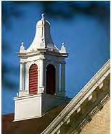
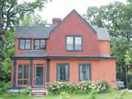
22 AGE OF HOUSING STOCK In the South Side University Neighborhood the majority of structures were built between pre and The Building Year Built Map (Figure 12) below illustrates the year built of the structures in the neighborhood. Figure 12 Building Year Built Figure 13 Year Structure Built HISTORIC DISTRICTS The South Side University Neighborhood s historic architecture is a source of community pride and a prominent neighborhood feature. As a result, the City has designated two local residential historic districts in the neighborhood; the South Side University Neighborhood Historic District and Barden Park Historic District. Local historic district designation is the best means of protecting significant architectural buildings from inappropriate alterations. The South Side University Neighborhood Historic District was established in 1999, expanded in 2002 and 2006, and currently contains approximately 261 buildings. The Barden Park Historic District was established in 2003 and contains eight properties, including the City s oldest park, Barden Park, which was platted in Both historic districts contain many examples of historic architectural styles, built between the 1880s and 1950, that are rare or well preserved. South Side University Neighborhood Master Plan University Neigh Page 17 CHAPTER 3 NEIGHBORHOOD PROFILE
23 EXISTING ZONING DISTRICTS Zoning districts are a general means of classifying land according to uses that are legally permitted by the City of St. Cloud. Zoning districts are typically similar to land use categories, but they also specify permitted uses and construction constraints, such as lot and building dimensions, setbacks, parking, and landscaping. The South Side University Neighborhood is primarily residential with non-residential uses on the north end of the neighborhood. The Existing Zoning Districts Map (Figure 14) on Page 19 illustrates the existing zoning districts in the South Side University Neighborhood. Below is a brief description of the different zoning districts in the neighborhood: The bulk of the neighborhood is zoned R-3 (Lodging House, Fraternity and Sorority House Residential District) and R-3A (Multiple Residential District). R-3 The purpose of the R-3 zoning district is to accommodate multi-tenant residences in the South Side University Neighborhood where there is demand for these housing types, as well as single family and two family residential development. The R-3 District also provides for non-residential uses, such as universities and other education institutions, which are compatible with surrounding residential neighborhoods. R-3A The purpose of the R-3A zoning district is to accommodate multi-tenant residences, as well as single-family, two-family, and multi-family residential development. The R-3A zoning district was established to reduce density, preserve historic structures, encourage single family and home owner occupancy, and allows limited non-residential uses that are compatible with surrounding residential neighborhoods. The remainder of the South Side University Neighborhood is zoned R-1 (Single Family Residential District), R-5 (General Multiple Residential District, R-7 (High Rise Residential District), C-4 (Fringe Central Business District), and PUD #59 (Douglas Allen Thielman Planned Unit Development). South Side University Neighborhood Master Plan University Neigh Page 18 CHAPTER 3 NEIGHBORHOOD PROFILE
24 Figure 14 Existing Zoning Districts R-1 The purpose of the R-1 zoning district is to provide for and preserve single-family residential development on larger lots within the City. The R-1 zoning district provides for limited non-residential uses that are compatible with surrounding residential neighborhoods. R-5 The purpose of the R-5 zoning district is to provide for, and preserve, quality high density residential development, including multi-family dwellings up to four (4) stories in height. The R-5 zoning district also provides for limited non-residential uses that are compatible with surrounding residential neighborhoods. R-7 The purpose of the R-7 zoning district is to accommodate the highest density residential environment of multi-family dwellings, of a significant height, within the City. Limited non-residential uses that are compatible with surrounding residential neighborhoods may be permitted. C-4 The purpose of the C-4 zoning district is to provide activities related in peripheral manner to those in the C-3, Central Business District. The customer may come to a particular establishment by automobile or on foot. Good traffic accessibility is essential. PUD #59 The purpose of PUD #59 is to allow an off-sale liquor store on Lots 10 and 11, Block 68, James Bowes Addition. South Side University Neighborhood Master Plan University Neigh Page 19 CHAPTER 3 NEIGHBORHOOD PROFILE
25 In 2008, the City closely reviewed the existing zoning and land uses in the South Neighborhood at a parcel level. Side University The Existing Zoning and Land Use Discrepancies Map (Figure 15) illustrates the parcels that have a lower housing density than the zoning district allows. In the area zoned R-3A, 39% of the parcels contain single family or two-family homes (area shown in black on Figure 15). In the area zoned R-5, 48% contain single family homes, 78% of the parcels contain three family homes or less, and 85% of the parcels contain four family homes or less (area shown in white on Figure 15). Figure 15 Existing Zoning and Land Use Discrepancies South Side University Neighborhood Master Plan University Neigh Page 20 CHAPTER 3 NEIGHBORHOOD PROFILE
26 EXISTING LAND USE In the South Side University Neighborhood, the top three existing land use categories by parcel are Multiple Family (duplex or greater housing density), Single Family, and Churches. The Existing Land Use By Parcel Map (Figure 16) illustrates the existing land use by parcel within the neighborhood. Figure 16 Existing Land Use The following is a list of existing land use categories by parcel: 1. Multiple Family 46% 2. Single Family 30% 3. Church 12% 4. Parking 10% 5. University 6% 6. Commercial 3% 7. Residential, Daycare, Temporary Shelter Facilities 1% 8. Vacant 1% 9. Right-of-Way 1% 10. City Less than 1% In the South Side University Neighborhood, the top three existing land uses by area are University (St. Cloud State University), Multiple Family (duplex or greater density), and Single Family. 1. University 61 acres 2. Multiple Family 53 acres 3. Single Family 30 acres 4. Parking 11 acres 5. Church 7 acres 6. Commercial 6 acres 7. City 4 acres 8. Residential, Daycare, Temporary Shelter Facilities 3 acres 9. Right-of-Way.66 acres 10. Vacant.62 acres South Side University Neighborhood Master Plan University Neigh Page 21 CHAPTER 3 NEIGHBORHOOD PROFILE
27 FUTURE LAND USE The 2003 Comprehensive Plan currently establishes a pattern of desired land uses through its Future Land Use Map (Figure 17). This map serves as the basis for decisions the City will make regarding zoning and other land use matters within the neighborhood. Revisions to the 2003 Comprehensive Plan Future Land Use Map are recommended in Chapter 6 of the master plan. Figure 17 Future Land Use A summary of the future land use designations is provided below: Low Density Residential - This category identifies existing residential development with densities at 1-6 units per acre. High Density Residential - This category identifies existing residential development with densities at units per acre. High Density Mixed Residential - This category accommodates future residential uses on undeveloped or redeveloped land with a variety of housing types at medium to high density, 6-24 units per acre. Commercial - This category identifies portions of St. Cloud that contain general commercial use, for example, highway-oriented businesses such as fast food restaurants, convenience stores, gas stations and other auto-oriented businesses and imited office and service uses. It is essential that neighborhood commercial centers remain small scale, providing service primarily to the surrounding neighborhood. Larger, autooriented businesses are not appropriate neighborhood commercial uses. Also, the architecture and site design of neighborhood commercial areas must be compatible with the surrounding neighborhood. South Side University Neighborhood Master Plan University Neigh Page 22 CHAPTER 3 NEIGHBORHOOD PROFILE
28 Downtown Mixed Use - This category provides for a variety of retail, service, public and office uses which are compatible with pedestrian movement and generate pedestrian activity in a compact, high-density environment. Parks and Open Space - This category identifies portions of St. Cloud that contain existing park and open space uses. Examples of park and open space uses include local and state parks, golf courses, wildlife areas, and other outdoor recreation facilities, as well as passive open spaces. Public/ Semi-Public - This category identifies portions of St. Cloud that benefit the public. This includes publicly owned uses, such as schools, city buildings, county buildings and utility/infrastructure related uses such as sewage treatment plants, and power plants. This includes semi-public private institutional uses such as hospitals, colleges, churches, cemeteries, etc. South Side University Neighborhood Master Plan University Neigh Page 23 CHAPTER 3 NEIGHBORHOOD PROFILE
29 TRANSPORTATION The South Side University Neighborhood is at the center of the St. Cloud region s transportation system, including trails, mass transit, and major roadways. This fact offers a great deal of opportunity for institutional and commercial uses in the neighborhood, as well as convenience for neighborhood residents. The availability of these systems combined with the neighborhood s proximity to the downtown also presents challenges in balancing the multi-modal transportation networks and maintaining a residential setting and quality of life. Automobile Traffic The South Side University Neighborhood is bound on three sides by major transportation corridors, including: Trunk Highway 23, 9 th Avenue South, and University Drive, and abuts two of the three existing crossing points of the Mississippi River in St. Cloud. These systems provide outstanding automobile connectivity for neighborhood residents and accessibility for commuters to St. Cloud State University and the downtown. 5 th Avenue South and 7 th Street South serve as the primary entrance points for the neighborhood and St. Cloud State University. 5 th Avenue South also serves to a lesser extent as a route for movements through the neighborhood to downtown. Mass Transit St. Cloud has a long history of community transit from the streetcars of 1887 to the current 16 fixed bus routes. The St. Cloud Metropolitan Transit Commission was named the #1 Transit System in North America in 1990 and 2007 Metro Bus recently surpassed 2 million riders since beginning service in SCSU and St. Cloud State University students and employees ride free throughout the community year round on Metro Transit creating the largest user base for the system. The accessibility of the mass transit system benefits not only St. Cloud State University, but the neighborhood by providing non-auto options for residents and decreasing the reliance upon on-street parking for commuters. Pedestrian and Non-Motorized Traffic The South Side University Neighborhood s proximity to the Mississippi River offers the opportunity to connect to the river trail systems north and south of the neighborhood. These trail corridors provide an opportunity for non-motorized traffic to St. Cloud State University, commuters to downtown, and a recreational amenity for residents. However, utilization of the internal sidewalk systems is challenging given the high traffic volumes in the neighborhood. South Side University Neighborhood Master Plan University Neigh Page 24 CHAPTER 3 NEIGHBORHOOD PROFILE
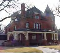
30 URBAN DESIGN The South Side University Neighborhood has a wealth of historic structures, natural amenities, and public improvements that is unique to many of the City s core neighborhoods and the region. These neighborhood assets exist in an uncoordinated pattern that has lacked a comprehensive approach to the preservation and enhancement of the features. As such, great potential exists to build upon these urban design elements to create a positive sense of arrival for visitors and a quality of life amenity for neighborhood residents. Gateways There is no universal agreement on the primary and secondary gateways to the neighborhood and St. Cloud State University. The creation of gateway edges and nodes can establish an awareness and positive sense of arrival for the historic and institutional areas of the neighborhood. Skalicky Plaza is a good example of the use of public art to announce the southern gateway to the St. Cloud State University campus. Similar opportunities exist along the neighborhood entry points from the major corridors bounding the neighborhood to the north and west. Neighborhood Streetscape One of the most desirable features of older neighborhoods is mature tree lined streets. The South Side University Neighborhood is fortunate to have this desirable feature. Small sections of streetscape features have been placed to build upon this feature and announce historic neighborhoods and SCSU. Current construction of the DeSoto Bridge and future reconstruction of the University Bridge and Lake George bridge provide an excellent opportunity to initiate a comprehensive streetscape improvement network through the neighborhood. Structures Architecture, especially in the historic districts, is a source of community pride and is an important feature of the neighborhood. The historic homes offer a glimpse of the primary styles of residential architecture within the community, as well as the history and stories of the neighborhood. While recent infill development has provided housing in close proximity to the St. Cloud State University campus, it has not incorporated high quality design elements and massing that provides a reasonable transition to these historic homes. South Side University Neighborhood Master Plan University Neigh Page 25 CHAPTER 3 NEIGHBORHOOD PROFILE
31 NEIGHBORHOOD ASSETS Neighborhood assets are community resources that include local buildings, services, recreational areas, and other community-related uses that residents visit, use, or need on a regular basis. The South Side University Neighborhood is characterized by a variety of local assets. St. Cloud State University (SCSU) is one such asset because it is one of the most highly accredited universities in the upper Midwest. SCSU was founded in 1869 as a normal school and was granted university status in Currently, SCSU is the largest member of the Minnesota State Colleges and Universities system and the second largest university in Minnesota. SCSU offers more than 175 programs of study on their 100-acre campus. Residents in the South Side University Neighborhood can utilize services from several SCSU facilities, such as the James W. Miller Learning Resource Center, Performing Arts Center, and various sports and recreation facilities. The St. Cloud Model College of Hair Design is a nationally accredited cosmetology college, which has been family owned for over 55 years. The campus is home to 10 buildings designed for cosmetology education and student housing. The styling clinic serves a large clientele, while classrooms provide students with the tools needed for nurturing their education. The neighborhood is home to several faith communities (Newman Center, St. Robert Bellarmine, Hope Covenant Church, University Lutheran Church of the Epiphany, Lutheran Student Fellowship, First United Methodist Church, Cornerstone Church, Holy Myrrh Bearers Orthodox Church, First Presbyterian Church of St. Cloud, Peace United Church of Christ, and Islamic Center of St. Cloud, ) that are also assets to the neighborhood. South Side University Neighborhood Master Plan University Neigh Page 26 CHAPTER 3 NEIGHBORHOOD PROFILE


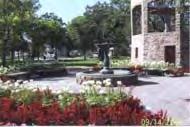
32 Barden Park is another prominent feature in the neighborhood. It was the first park identified in the original town site plat of St. Cloud in South Side University Neighborhood residents have enjoyed strolling the paths, planting gardens and listening to outdoor concerts by the Municipal Band for almost 150 years. Barden Park has played a significant role as a major community gathering place, and the granite faced bandstand has been an architectural landmark in the neighborhood for the past 78 years. The Beaver Island Trail, which runs along the Mississippi River thru the St. Cloud State University campus to the St. Cloud Civic Center, provides recreational opportunities for neighborhood residents. The South Side Neighborhood Historic District and Barden Park Historic District are located entirely within the South Side University Neighborhood and are additional local assets. Physical elements, such as historic light fixtures and historic street signs bring a unique character to parts of the neighborhood. In 2004, the City developed the City of St. Cloud Residential Historic Districts Preservation Design Manual to manage the appearance and dimension of physical features of buildings and property; therefore, the historic districts are designed to maintain the historic elements of the neighborhood. Many houses in the neighborhood, dating as far back as the early 1900s, still have significant historic value. A small commercial area and St. Cloud City Hall are assets to the South Side University Neighborhood. These particular uses are primarily located in the north section of the neighborhood along Trunk Highway 23/Division St. South Side University Neighborhood Master Plan University Neigh Page 27 CHAPTER 3 NEIGHBORHOOD PROFILE


33 The Mississippi River is the neighborhood s only natural feature that also doubles as a neighborhood asset. The riverfront, which follows along the east edge of the SCSU campus and along the front yards of 3 rd Ave. So., is currently underutilized. The riverfront provides a variety of recreational and general open space opportunities. Neighborhood assets may also include opportunities for neighborhood improvement. The former Coborn s grocery store site, located on 5 th Ave. So., is one such opportunity. After moving of the neighborhood in 2007, the building has been demolished; and future mixed use development is expected in the near future. There are several neighborhood amenities that are located outside of the South Side University Neighborhood, but are frequently visited by neighborhood residents, such as Lake George, the Great River Regional Library, and Downtown St. Cloud. South Side University Neighborhood Master Plan University Neigh Page 28 CHAPTER 3 NEIGHBORHOOD PROFILE
34 The Neighborhood Assets Map (Figure 18) illustrates the different amenities in neighborhood. the Figure 18 Neighborhood Assets South Side University Neighborhood Master Plan University Neigh Page 29 CHAPTER 3 NEIGHBORHOOD PROFILE

35 CHAPTER 4 NEIGHBORHOOD ISSUES Before beginning to plan for the future of the South Side University Neighborhood, it is necessary to look at the neighborhood as it is today and to inventory the positive and negative aspects that are shaping the area. Census data, activities at public meetings, and voting were some of the tools used to generate thinking among participants regarding issues facing the neighborhood. HEALTHY NEIGHBORHOODS PARTNERSHIP PROGRAM SWOT FINDINGS Preparation for the South Side University Neighborhood Master Plan began in 2005 with the neighborhood s participation in the Healthy Neighborhoods Partnership Program. Completion of the Strengths, Weaknesses, Opportunities, and Threats process resulted in the neighborhood identifying the unique assets, challenges, and priorities for improving its quality of life. The following is a summary of those findings, while the full list of Assets, Challenges, and Desired Outcomes are presented in Appendix C Community Visioning Results: Figure 19 Neighborhood Top 10 Assets and Challenges South Side University Neighborhood Top 10 Assets 1. Historic / Quality Homes 2. Close to Parks/Lake George 3. Good Neighbors 4. Faith Community 5. Walking (sidewalk system and bike paths) 6. Near Mississippi River 7. Diversity (age, ethnicity, etc.) 8. Location (downtown, SCSU, etc.) 9. Cultural Events 10. Proximity to Schools South Side University Neighborhood Top 10 Challenges 1. Deteriorating Properties 2. Noisy Bar Crowds / Transportation 3. High Traffic 4. Rental % Too High 5. Excessive Alcohol Use 6. Lack of On-Street Parking 7. Trash/Litter/Broken Glass/Furniture 8. Move-In Day / Homecoming 9. Vandalism 10. Transitional / Short-Term Residents South Side University Neighborhood Master Plan University Ne Page 30 CHAPTER 4 NEIGHBORHOOD ISSUES
.")
36 2008 NEIGHBORHOOD VISIONING ACTIVITIES On February 20, 2008, approximately 200 South Side University Neighborhood residents participated in a Community Input session to offer input for the South Side University Neighborhood Master Plan and assist the 5 th Avenue redevelopment team regarding the design and issues related to the proposed 5 th Avenue redevelopment (former Coborn s site). The complete results of the information gathered at the Community Input session are presented in Appendix C Community Visioning Results. The following is a synopsis of the comments offered at the visioning sessions: Land Use Issues Extension of commercial use on 5th Avenue, but southern terminus varies significantly Preservation (existing) and return of single family homes for owner occupancy Multiple-family redevelopment in appropriate locations (close to campus and University Dr), amount varies significantly Green corridors and maintain park Define campus edge to the west Neighborhood Amenity Issues 5th Avenue Corridor extensive streetscape features Entry monuments 5th Avenue (north & south), campus edges, and 9th Avenue access points Street lighting throughout internal street network Trash receptacles along major pedestrian corridors In-fill street tree gaps Planters, bicycle racks, and bollards at commercial development sites and campus edges Issues Map Improve traffic safety: 5th Avenue Improve pedestrian and bike access: 5th Avenue, Division, 6th Avenue, River, Downtown Commercial redevelopment: 5th Avenue Residential redevelopment for ownership: east of 5th Avenue Preserve historic homes: Highbanks and throughout area by rezoning and historic district expansion Park improvements: trail connection to river, Barden Park enhancement, ice rink, riverfront overview sites Historic neighborhood gateways SCSU gateways: Division St., University Dr., 5th Ave., 7th St. South Side University Neighborhood Master Plan University Ne Page 31 CHAPTER 4 NEIGHBORHOOD ISSUES


37 Heritage Preservation Interest in expansion of existing historic districts: o Expand to University Drive and 9th Avenue o Expand to corner of 9th and Division Celebrate neighborhood s historic homes Strengthen rules regarding home demolition Reoccupy homes with home owner occupants Identify other means to maintain historic homes South Side University Neighborhood Master Plan University Ne Page 32 CHAPTER 4 NEIGHBORHOOD ISSUES

38 SCSU COMPREHENSIVE FACILITIES PLANNING SESSIONS The following is a compilation of issues raised by neighborhood residents, university staff, and university students during the community visioning sessions conducted in the Spring of 2008 as part of SCSU s preparation to update its comprehensive facilities plan. University/Neighborhood/Community: points of intersection and/or mutual support Need to transition better between campus and neighborhood Need to define points of entry Establish a unifying visual theme and aesthetic treatments for campus arrival Sustainability/relationship issues involving University and community Improve energy use and recycling efforts on campus Enhance quality of life in adjacent neighborhoods Improve off-campus housing opportunities Consider LEED standards and other green efforts on campus Vehicular access, transportation and parking issues in and around the University Resolve parking demand/supply on and surrounding campus Explore means to improve utilization of mass transit Address traffic flow to/from new parking ramp Enhance bike and pedestrian ways Improve wayfinding on campus Pedestrian movement on and around the University Snow removal from sidewalks Failure of autos to yield for pedestrians Consider potential for skyways and tunnels Landscape and grounds issues Improve current spotty and fragmented campus landscaping Unified landscaping scheme across campus Better use of the river as campus landscaping Too much hardscaping, not enough softscaping/greenscaping Need for functional landscaping (e.g., seating) South Side University Neighborhood Master Plan University Ne Page 33 CHAPTER 4 NEIGHBORHOOD ISSUES
39 Facilities condition and sustainability Need for large student gathering space to build sense of campus connection Enhancement of technology Consider expansion of campus boundaries Repair and renovate existing buildings Safety and security considerations Improve safety in surrounding neighborhoods Improve campus lighting, phones, and cameras Consider enhancing relationship between campus and police department Academic concerns with facilities Establish building construction/design principles for campus Create unified and revitalized look for campus and buildings Campus building space shortages Renovation of student halls Consideration for student service, recreation, and performance facilities Better utilize partnerships with private sector for facility improvements Channel student energy through on-campus activities and facilities Update and expand a variety of campus activity and service facilities South Side University Neighborhood Master Plan University Ne Page 34 CHAPTER 4 NEIGHBORHOOD ISSUES
40 SUMMARY OF SOUTH SIDE UNIVERSITY NEIGHBORHOOD ISSUES The following findings were derived from the conclusions drawn from a synthesis of all results and comments from the Healthy Neighborhoods Partnership Program, 2008 Neighborhood Master Plan open houses, and the SCSU comprehensive facilities plan stakeholder meetings. NEIGHBORHOOD AMENITIES Figure 20 Neighborhood Amenities HNPP City SCSU Historic Homes X X X Close to Parks/Trails X X Good Neighbors X X Faith Community X X Walkable X X Near Mississippi River and Lake George X X X Diversity of Residents X X Location X X Cultural Events X X X Proximity to SCSU X Mass Transit X X Barden Park X X Mature Landscaping X X Organized Neighborhood X X Mix of Housing X X X 5 th Ave. So. Corridor X X X Commercial use at Division St. and 5 th Ave. So. Current and potential commercial redevelopment along Division St. and 5 th Ave. So., which is compatible with existing neighborhood land use and meets community needs, is a source of concern to the neighborhood. Proximity to Downtown The South Side University Neighborhood s proximity to Downtown is an important feature; however, the Downtown area s transition into the neighborhood, including but not limited to traffic concerns, land use, neighborhood gateways and 5 th Ave. So. in general, is of concern. South Side University Neighborhood Master Plan University Ne Page 35 CHAPTER 4 NEIGHBORHOOD ISSUES
41 Beaver Island Trail Opportunities exist to connect north towards the St. Cloud Hospital/Whitney Park area to provide an additional amenity for the neighborhood. Architecture/Historic Districts Architecture, especially in the historic districts, is a source of community pride and is an important feature of the neighborhood. Institutional Infrastructure The neighborhood s institutional infrastructure (including schools, community services & programs, churches, and neighborhood groups) has an important presence in the community and should have a role in neighborhood revitalization efforts. People/Diversity The South Side University Neighborhood s population is diverse and active, broad-based participation in neighborhood improvement efforts is essential. NEIGHBORHOOD ISSUES Figure 21 Neighborhood Issues HNPP City SCSU Deteriorating Properties X X Noisy Bars X X Traffic X X X Too Much Rental X X X Excessive Alcohol Use X X lack of On-Street Parking X X X Trash/Litter X X Move-In Day X Vandalism X X X Short Term Residents X Improve University/Community Gateways X X Potential Redevelopment Housing/Rental X X More Owner-Occupied Housing X Define Campus Edge X Pedestrian Safety X X X Public Safety X X X Preserve Historic Homes X Park and Trail Improvements X X Lack of Campus Parking X Improve Mass Transit Options X Improve Streetscaping and Landscaping X Enhance Use of the Mississippi River X X X Enforcement X X South Side University Neighborhood Master Plan University Ne Page 36 CHAPTER 4 NEIGHBORHOOD ISSUES
 approaches. Traffic/Parking Traffic and on-street parking in various areas of the neighborhood are sources of concern.")
42 Crime Addressing perceptions and incidents of crime, especially as it pertains to excessive alcohol use, is a major concern of the neighborhood and signals an opportunity for both conventional (e.g. exchange car patrol for beat patrol) and unconventional (e.g. involve institutional infrastructure) approaches. Traffic/Parking Traffic and on-street parking in various areas of the neighborhood are sources of concern. Gateways There is no universal agreement on neighborhood gateways, which would provide opportunities to better announce arrival into the neighborhood and transition from adjacent areas. Multi-Family/Single-Family/Overcrowding Changes in property ownership and occupancy of residential structures have created problems with overcrowding. Physical Deterioration As an established urban neighborhood, the South Side University Neighborhood s infrastructure, buildings, and streets exhibit signs of deterioration which affects the attractiveness, marketability, and perceptions of the area. Former Coborn s Site The redevelopment of the former Coborn s site on 5 th positive image for the neighborhood. Ave. So. is essential to creating a South Side University Neighborhood Master Plan University Ne Page 37 CHAPTER 4 NEIGHBORHOOD ISSUES

43 CHAPTER 5 NEIGHBORHOOD VISION AND GOALS The South Side University Neighborhood s vision and goals were created through public input and the goals and strategies identified in the St. Cloud 2003 Comprehensive Plan. The vision statement is intended to be a long-range description of the neighborhood that can be used to help with immediate decision making and action plan implementation. ST. CLOUD 2003 COMPREHENSIVE PLAN NEIGHBORHOOD GOALS Community Appearance/Livability Goal #1: Maintain and enhance the appearance, integrity, heritage, identity and local character of the city s built environment. Strategies: Create, strengthen and maintain the appearance of the city gateways and key transportation corridors through streetscaping, design standards, zoning, trails, lighting, sidewalks, signage and other tools. Develop and enforce design, performance, development and site planning standards, incentives and resources to ensure quality development. Work with local historical organizations to create and maintain an inventory of historic community resources. Prepare and/or adopt appropriate guidelines or regulations for the use or reuse of identified historic properties. Support the efforts of local historical organizations in promoting the preservation of historically significant places and records where practical and economically viable. Explore methods and funding options to uphold the general appearance of older buildings and neighborhoods through their maintenance and upkeep. South Side University Neighborhood Master Plan UniversPage 38 CHAPTER 5 NEIGHBORHOOD VISION AND GOALS
44 Community Appearance/Livability Goal #2: Enhance community and neighborhood livability. Strategies: Ensure new developments are connected to existing development through the efficient use of streets, utilities and infrastructure. Encourage quality mixed-use development and/or the appropriate development of housing, shopping and employment in proximity to each other. Encourage the integration of multi-modal access including parking, sidewalks and bike paths within new development. Encourage a variety of types of neighborhood designs, including neo-traditional and other alternative designs. Encourage commercial developments with residential uses above in both new development and where existing opportunities occur, such as downtown. Community Appearance and Livability Goal #3: Maintain adequate active and passive open space to meet the needs of the community. Strategies: Require the integration of parks and green space within new development to ensure that residential neighborhoods have adequate access to park facilities. Work to link area parks, neighborhoods, natural amenities, community facilities and local and regional trails. Continue to support and create new forms of funding for equipment, improvements, and maintenance of new and existing neighborhood parks and recreational facilities. Housing Goal #2: Create a high-quality environment in all residential neighborhoods. Strategies: Enforce necessary codes to ensure the continued maintenance of the existing housing stock. Identify methods and funding options to promote the improvement of the existing housing stock, including retrofitting existing homes to better serve today s families. Identify or develop methods and funding options to encourage the rehabilitation or redevelopment of substandard housing. South Side University Neighborhood Master Plan UniversPage 39 CHAPTER 5 NEIGHBORHOOD VISION AND GOALS


45 Encourage infill housing where appropriate. Examine and change, if necessary, zoning and other regulations to ensure they allow the upgrading of older homes, neighborhoods, and small, irregularly shaped lots. Environment Goal #2: Recognize the Mississippi and other rivers as major recreational, environmental and aesthetic assets to the community. Strategies: Maintain existing public accesses to the rivers and increase public access to the river corridors in new development and redevelopment projects. Provide bicycle and pedestrian trails that connect the rivers to downtown, neighborhoods, parklands and other natural areas. Maintain and enhance views of the rivers when possible, particularly during public facility projects. Enhance river-related recreational and park opportunities by acquiring parkland adjacent to the rivers in the city s planned growth areas. South Side University Neighborhood Master Plan UniversPage 40 CHAPTER 5 NEIGHBORHOOD VISION AND GOALS
46 SOUTH SIDE UNIVERSITY NEIGHBORHOOD VISION While the 2003 Comprehensive Plan offers general guidance regarding the vision, goals, and policies associated with core neighborhoods through the community, the character of each neighborhood is established by its unique set of assets and challenges. The South Side University Neighborhood stakeholders have prioritized the following characteristics through the Healthy Neighborhoods Partnership Program and Neighborhood Master Plan Open Houses as desirable given the current assets of the neighborhood and opportunities for continued neighborhood enhancements. Figure 22 Healthy Neighborhoods Partnership Program Desired Outcomes Healthy Neighborhoods Partnership Program Desired Outcomes Better enforcement of ordinances 22 More homesteaders versus rentals 16 Improved maintenance of property 12 Increased cooperation with SCSU (student behavior) 11 Better relationship for all stakeholders 8 More incentives for property rehabilitation 6 Complete restoration of Barden Park 5 More neighborhood gatherings 5 Retain and recruit businesses 4 5 th Ave. small business district 4 Figure 23 Most Desired Neighborhood Characteristics South Side University Neighborhood Most Desired Neighborhood Characteristics I could walk to a neighborhood market, bookstore, coffee shop, etc. 40 My streets would be safe and well-lit 37 I would have direct access to natural amenities (lakes, nature preserves, etc.) 31 There would be connections to walking/bike paths 22 I could walk to a park 20 I could walk to, or would live in close proximity to public or cultural facilities (library, 19 swimming pool, museum, etc.) Homesteaders in more existing homes 18 I would know my neighbors 17 I could easily access public transit (bus, LRT, train, etc.) 16 I could park on the street 13 I could walk to, or would live in close proximity to work/school 13 There would lots of trees 12 There would be a diverse mix of people (ethnicity, income, age, etc.) 10 South Side University Neighborhood Master Plan UniversPage 41 CHAPTER 5 NEIGHBORHOOD VISION AND GOALS

47 Based upon the desired outcomes and neighborhood characteristics gained from the Healthy Neighborhoods Partnership Program and the Neighborhood Master Plan Open Houses, the following vision statement has been developed for the South Side University Neighborhood. This neighborhood vision statement has been developed as part of the South Side University Neighborhood Master Plan to establish a consistent point of reference for the creation of this plan s goal and action statements. Furthermore, the vision statement can similarly be used by the City, University, Neighborhood Association, and other neighborhood stakeholders as a compass in considering implementation activities on into the future. Figure 24 Neighborhood Vision South Side University Neighborhood Vision Welcome to the South Side University of the year 2015! Our safe, secure, and stable community is made up of a diverse social fabric and a rich physical fabric that make our near-downtown neighborhood and its beautiful historic districts the envy of the community and a benefit to surrounding areas. Our location near a highway, a vibrant downtown, churches, university campus, and the Mississippi River and Lake George offers residents amenities to higher levels of recreation and conveniences than those in other neighborhoods. We offer a pedestrian-friendly environment where residents sit on their front porches, walk their dogs, involve themselves in civic-minded pastimes and seek casual, chance meetings to have conversations and greetings with community members. We celebrate our diversity of residents and integrate renters and homeowners through neighborhood interaction and events. We have enhanced the historically significant aspects of the neighborhood through property owner accountability and City programs that assist with maintaining property appearances and conditions, returning structures to their original uses (e.g. single-family homes being used as multi-family dwellings returned to single-family), and protecting the character of our historic buildings. South Side University Neighborhood Master Plan UniversPage 42 CHAPTER 5 NEIGHBORHOOD VISION AND GOALS
48 SOUTH SIDE UNIVERSITY NEIGHBORHOOD GOALS The South Side University Neighborhood Master Plan process has established six specific focus areas in creating a framework for future neighborhood enhancement. Included within these focus areas is an overriding objective statement that reiterates and further details the desired outcome set by the neighborhood vision statement. These focus areas are further outlined by individual goals based upon the myriad of issues that must be addressed to meet each objective. The following focus areas and individual goals are listed in no particular order: Figure 25 Physical Character Objective and Goals Physical Character Objective: To ensure that redevelopment and public and private improvements respect and enhance the South Side University neighborhood s significant historical and institutional assets Goal1: STREETSCAPE To define and implement a palette of streetscape elements that establishes a unique sense of arrival for the gateways to the South Side University Neighborhood and St. Cloud State University Goal 2: MIXED LAND USE To establish building and site design standards for mixed use redevelopment that create a pedestrian friendly environment and transition well to surrounding properties and downtown Goal 3: LANDSCAPING To preserve the existing natural amenities of the South Side University Neighborhood and plant additional greenscape features within public right-of-way and private properties Goal 4: PRESERVATION/RESTORATION OF HISTORIC HOMES/BUILDINGS Develop regulations, funding, and information resources that assist existing and new property owners with restoration and rehabilitation of properties in the South Side University Neighborhood Goal 5: BUILDING DESIGN To establish a high standard of building design that compliments surrounding properties and enhances the desired character of the South Side University Neighborhood. Goal 6: SITE DESIGN To establish minimum site design standards related to parking, refuse collection, and other considerations that enhance the appearance of the South Side University Neighborhood. South Side University Neighborhood Master Plan UniversPage 43 CHAPTER 5 NEIGHBORHOOD VISION AND GOALS
49 Figure 26 Public Safety Objective and Goals Public Safety Objective: To improve the perception and reality of personal and property safety within the neighborhood Goal 1: POLICE PRESENCE/COMMUNITY POLICING To improve the perception of public safety and reduce actual incidents by increasing proactive involvement and officer presence in the South Side University Neighborhood Goal 2: Goal 2: CRIME PREVENTION THROUGH ENVIRONMENTAL DESIGN (CPTED) To educate property owners of environmental design practices that discourage inappropriate behaviors on private property, as well as, implement design changes on public right-of-way and SCSU campus. Goal 3: RESIDENT/LANDLORD INVOLVEMENT To engage citizen and property owners in reducing inappropriate behaviors in the South Side University Neighborhood. Figure 27 Housing Objective and Goals Housing Objective: To re-establish an appropriate balance of owner-occupied and rental housing that fosters downtown and university vitality, as well as the preservation of the neighborhood s historic features Goal 1: HOMESTEADING To identify and implement ordinance revisions, incentives, and promotional opportunities to increase the owner occupancy of existing homes within the South Side University Neighborhood Goal 2: NEW CONSTRUCTION To identify and implement ordinance revisions, incentives, and promotional opportunities to encourage owner-occupied or higher amenity rental units within new construction in the South Side University Neighborhood South Side University Neighborhood Master Plan UniversPage 44 CHAPTER 5 NEIGHBORHOOD VISION AND GOALS
50 Figure 28 Transportation Objective and Goals Transportation Objective: To provide multi-modal opportunities (automobile, mass transit, pedestrian, and non-motorized) to safely and efficiently move within, to/from, and through the neighborhood Goal 1: AUTOMOBILES To define and implement changes to the local street network that reduces drive time through and to the South Side University Neighborhood and minimize automobile conflicts with non-motorized transportation Goal 2: PEDESTRIANS To define and implement changes to pedestrian behavior and public improvements that allow for safe pedestrian movements within the South Side University Neighborhood Goal 3: TRANSIT To define and implement operational changes and public improvement modifications that allow for greater use of mass transit and reduces conflicts with automobile movements Goal 4: PARKING To ensure that public and private properties provide sufficient off-street parking so as not to overburden the use of the local street system and negatively impact automobile, mass transit, and nonmotorized movements within the South Side University Neighborhood Goal 5: BICYCLES To define routes and implement physical modifications that promote safe bicycle use to and through the South Side University Neighborhood Figure 29 Land Use & Redevelopment Objective and Goals Land Use & Redevelopment Objective: To establish a framework that preserves the neighborhood s existing historic properties and focuses public/private investment in areas appropriate for commercial, institutional, and residential redevelopment Goal 1: PRESERVATION OF SINGLE FAMILY HOMES To establish regulatory and financial incentives for the preservation of the remaining single family housing stock and conversion of housing back to lesser densities within the South Side University Neighborhood Goal 2: NATURE AND PARKS To identify and implement means of improving awareness and utilization of the Mississippi River, Lake George, Barden Park, and other open spaces connected to the South Side University Neighborhood Goal 3: COMMERCIAL USE To identify financial incentives and other means of fostering redevelopment within areas guided for redevelopment of commercial use Goal 4: CAMPUS INTEGRATION To work proactively with St. Cloud State University on campus construction and expansion plans to guide development in to areas designated for institutional expansion/redevelopment Goal 5: LAND USE EDGES - To establish a framework and tools for the preservation, enhancement, and redevelopment of land uses within the South Side University Neighborhood South Side University Neighborhood Master Plan UniversPage 45 CHAPTER 5 NEIGHBORHOOD VISION AND GOALS
51 Figure 30 Code Enforcement Objective and Goals Code Enforcement Objective: To enhance the effectiveness of limited city resources by modifying existing policies and regulations related to housing inspections, zoning, and property maintenance Goal 1: OVERCROWDING To increase property owner and tenant awareness, as well as, identification and enforcement of violations related to housing occupancy limitations Goal 2: OWNER/TENANT INVOLVEMENT To work proactively with property owners, landlords, and renters to increase awareness and self-policing of appropriate property maintenance standards and appropriate personal behaviors Goal 3: EFFECTIVE CODE ENFORCEMENT- To continue to monitor and modify operational procedures and City codes/policies, as needed, to ensure effective enforcement of property condition, maintenance, and use standards South Side University Neighborhood Master Plan UniversPage 46 CHAPTER 5 NEIGHBORHOOD VISION AND GOALS

52 CHAPTER 6 NEIGHBORHOOD FRAMEWORK AND STRATEGIES NEIGHBORHOOD STRATEGIES The following tables detail the specific strategies and actions to be undertaken by neighborhood stakeholders to realize the vision established by the South Side University Neighborhood Master Plan. To assist in the implementation of the identified neighborhood goals and strategies, these tables identify the parties responsible for the initiation and on-going oversight and maintenance of the specific actions. The following individual goals and actions are presented in no particular order: Figure 31 Physical Character Objective, Goals, and Actions Physical Character Objective: To ensure that redevelopment and public and private improvements respect and enhance the South Side University neighborhood s significant historical and institutional assets Goal 1: STREETSCAPE To define and implement a palette of streetscape elements that establishes a unique sense of arrival for the gateways to the South Side University Neighborhood and St. Cloud State University Action A: Develop a streetscape improvement project(s) based upon the design palette for lighting, benches, and other street features and locations established by the Master Plan s urban design framework plan. Action B: Develop a gateway monumentation/signage project(s) for the primary gateways to the Southside University Neighborhood and SCSU campus that complements the Master Plan s urban design framework plan and land use and redevelopment plan. Who Initiates City Planning City Engineering South Side University Neighborhood Association Who Initiates SCSU City Planning South Side University Neighborhood Association Who Maintains City Public Works South Side University Neighborhood Association Who Maintains SCSU City Parks South Side University Neighborhood Association Volunteers South Side University Neighborhood Master Plan NeighPage 47 CHAPTER 6 NEIGHBORHOOD FRAMEWORK AND STRATEGIES
53 Goal 2: MIXED LAND USE To establish building and site design standards for mixed use redevelopment that create a pedestrian friendly environment and transition well to surrounding properties and downtown Action A: Develop an overlay district for the 5 th Avenue South corridor establishing massing and urban design standards for future commercial and mixed-use redevelopment suggested by the Master Plan s land use and redevelopment framework plan. Who Initiates City Planning Planning Commission Who Maintains City Planning Planning Commission Goal 3: LANDSCAPING To preserve the existing natural amenities of the South Side University Neighborhood and plant additional greenscape features within public rightof-way and private properties Goal 4: PRESERVATION/ RESTORATION OF HISTORIC HOMES/BUILDINGS Develop regulations, funding, and information resources that assist existing and new property owners with restoration and rehabilitation of properties in the South Side University Neighborhood Action A: Investigate the benefits of adopting a tree preservation ordinance for the South Side University Neighborhood and other areas throughout the community. Action B: Identify missing boulevard trees within the South Side University Neighborhood and develop a boulevard tree replacement plan. Action C: Develop standards for the maintenance of landscaped features upon private property. Action A: Explore partnerships with entities, such as St. Cloud State University or St. Cloud Technical College, to assist property owners with design and construction of rehabilitation and renovation projects. Action B: Assess the potential for expansion of the South Side Historic District to appropriate blocks. Action C: Consider the adoption of a historic conservation district for those areas not appropriate for historic district expansion Who Initiates City Planning Planning Commission Who Initiates South Side University Neighborhood Association City Parks Who Initiates City Planning Planning Commission Who Initiates South Side University Neighborhood Association SCSU St. Cloud Historic Neighborhood Preservation Association Who Initiates City Planning St. Cloud Heritage Preservation Commission Who Initiates City Planning St. Cloud Heritage Preservation Commission Who Maintains City Planning Planning Commission Who Maintains City Parks Who Maintains City Health & Inspections Who Maintains South Side University Neighborhood Association SCSU St. Cloud Historic Neighborhood Preservation Association Who Maintains City Planning St. Cloud Heritage Preservation Commission Who Maintains City Planning St. Cloud Heritage Preservation Commission South Side University Neighborhood Master Plan NeighPage 48 CHAPTER 6 NEIGHBORHOOD FRAMEWORK AND STRATEGIES
54 Who Initiates Who Maintains Action D: Develop an incentives program for the renovation of existing single-family homes in the South Side University Neighborhood, such as the This Old House Program. South Side University Neighborhood Association St. Cloud Housing and Redevelopment Authority Who Initiates South Side University Neighborhood Association St. Cloud Housing & Redevelopment Authority Who Maintains Action E: Establish clearinghouse for resource information regarding home rehabilitation and restoration, such as webpage, advisory group, etc. Action F: Develop an information packet regarding HPC process, city permitting, and other helpful hints/tips for distribution to property owners, real estate brokers, contractors, and others. South Side University Neighborhood Association St. Cloud Heritage Preservation Commission SCSU Who Initiates City Planning South Side University Neighborhood Association South Side University Neighborhood Association St. Cloud Heritage Preservation Commission SCSU Who Maintains City Planning South Side University Neighborhood Association Goal 5: BUILDING DESIGN - To establish a high standard of building design that complements surrounding properties and enhances the desired character of the South Side University Neighborhood Action A: Develop an overlay district for those areas guided for multiplefamily redevelopment establishing heightened standards of building design and materials. Action B: Develop an incentives program encouraging renovation of non-contributing buildings to adopted neighborhood design standards. Who Initiates City Planning Planning Commission Who Initiates South Side University Neighborhood Association St. Cloud Housing and Redevelopment Authority Who Maintains City Planning Planning Commission Who Maintains South Side University Neighborhood Association St. Cloud Housing and Redevelopment Authority Goal 6: SITE DESIGN - To establish minimum site design standards related to parking, refuse collection, and other considerations that enhance the appearance of the South Side University Neighborhood Action A: Develop an overlay district establishing massing and building placement standards for those areas suggested for multiple-family redevelopment by the Master Plan s land use and redevelopment framework plan. Action B: Review existing standards for greenspace, refuse screening, signage, parking and other site design matters. Who Initiates City Planning Planning Commission Who Initiates City Planning Planning Commission Who Maintains City Planning Planning Commission Who Maintains City Planning Planning Commission South Side University Neighborhood Master Plan NeighPage 49 CHAPTER 6 NEIGHBORHOOD FRAMEWORK AND STRATEGIES
55 Figure 32 Housing Objective, Goals, and Actions Housing Goal 1: HOMESTEADING To identify and implement ordinance revisions, incentives, and promotional opportunities to increase the owner occupancy of existing homes within the South Side University Neighborhood Goal 2: NEW CONSTRUCTION To identify and implement ordinance revisions, incentives, and promotional opportunities to encourage owner-occupied or higher amenity rental units within new construction in the South Side University Neighborhood Objective: To re-establish an appropriate balance of owner-occupied and rental housing that fosters downtown and university vitality, as well as the preservation of the neighborhood s historic features Who Maintains Who Initiates Action A: Develop an incentives program for the purchase of existing single-family homes in the South Side University Neighborhood. Action B: Consider the creation of a community land trust (CLT) focused on increasing home owner occupancy of existing homes in the South Side University Neighborhood. Action C: Review current tax structure to determine if it is creating an uneven playing field between rental and owner occupancy of existing single-family homes and lobby for changes as needed. Action A: Develop an incentives program for the construction of new owner occupied or high amenity rental housing in areas suggested by the Master Plan s land use and redevelopment framework plan. Action B: Ensure that incentives are tied to the appropriate location and design of new construction in the South Side University Neighborhood. South Side University Neighborhood Association St. Cloud Housing & Redevelopment Authority Neighborhood Coalition Who Initiates South Side University Neighborhood Association Central MN Housing Partnership St. Cloud Housing & Redevelopment Authority Who Initiates South Side University Neighborhood Association City Planning Who Initiates South Side University Neighborhood Association St. Cloud Housing & Redevelopment Authority Who Initiates South Side University Neighborhood Association St. Cloud Housing and Redevelopment Authority City Planning South Side University Neighborhood Association St. Cloud Housing & Redevelopment Authority Neighborhood Coalition Who Maintains South Side University Neighborhood Association Central MN Housing Partnership St. Cloud Housing & Redevelopment Authority Who Maintains South Side University Neighborhood Association City Planning Who Maintains South Side University Neighborhood Association St. Cloud Housing & Redevelopment Authority Who Maintains South Side University Neighborhood Association St. Cloud Housing and Redevelopment Authority City Planning South Side University Neighborhood Master Plan NeighPage 50 CHAPTER 6 NEIGHBORHOOD FRAMEWORK AND STRATEGIES
56 Figure 33 Public Safety Objective, Goals, and Actions Public Safety Objective: To improve the perception and reality of personal and property safety within the neighborhood Action A: Investigate the potential for location of police substations upon the SCSU campus or other locations throughout the South Side University Neighborhood. Who Initiates City Police SCSU Who Maintains City Police SCSU Action B: Consider the installation of emergency call boxes throughout the South Side University Neighborhood that connect to SCSU Public Safety, St. Cloud Police, or a neighborhood substation. Who Initiates City Police SCSU Who Maintains City Police SCSU Who Initiates Who Maintains Goal 1: POLICE PRESENCE/COMMUNITY POLICING To improve the perception of public safety and reduce actual incidents by increasing proactive involvement and officer presence in the South Side University Neighborhood Action C: Continue to support and utilize the Community Crime Impact Team (CCIT) as a means to proactively address neighborhood public safety concerns. Action D: Increase the presence of police officers through walking and biking patrols of the South Side University Neighborhood. City Police South Side University Neighborhood Association Neighborhood Coalition Who Initiates City Police Who Initiates City Police South Side University Neighborhood Association Neighborhood Coalition Who Maintains City Police Who Maintains Action E: Consider a housing incentives program for police officers residing in the South Side University Neighborhood and other core neighborhoods. South Side University Neighborhood Association St. Cloud Housing and Redevelopment Authority City Police Who Initiates South Side University Neighborhood Association St. Cloud Housing and Redevelopment Authority City Police Who Maintains Action F: Advocate for increased staffing of the Police Department. South Side University Neighborhood Association Neighborhood Coalition South Side University Neighborhood Association Neighborhood Coalition South Side University Neighborhood Master Plan NeighPage 51 CHAPTER 6 NEIGHBORHOOD FRAMEWORK AND STRATEGIES
57 Action A: Consider the appropriate location of street lighting as part of a streetscape improvement project to enhance public safety in the South Side University Neighborhood. Who Initiates City Engineering City Police South Side University Neighborhood Association Who Maintains City Public Works Goal 2: CRIME PREVENTION THROUGH ENVIRONMENTAL DESIGN (CPTED) To educate property owners of environmental design practices that discourage inappropriate behaviors on private property, as well as, implement design changes on public right-of-way and SCSU campus Action B: Work with the neighborhood, neighborhood watches, and St. Cloud Police Department to develop a porch lighting program with possible incentives for participation. Action C: Consider the installation of surveillance cameras in key locations. Who Initiates Neighborhood Watches City Police Who Initiates City Police SCSU Who Maintains Neighborhood Watches City Police Who Maintains City Police SCSU Action D: Develop incentives for rental property owner participating in Phase II and III of the Crime Free Multi-Housing Program which includes an evaluation of the CPTED improvements to private properties. Offer similar advice to owner-occupied housing through neighborhood watches or through individual consultation. Who Initiates City Planning City Police Who Maintains City Administration Goal 3: RESIDENT/LANDLORD INVOLVEMENT To engage citizens and property owners in reducing inappropriate behaviors in the South Side University Neighborhood Action A: Make the Crime Free Multi Housing Program mandatory for rental licensing or develop incentives for participation. Action B: Work with the South Side University Neighborhood Association and private property owners to develop and maintain neighborhood watches throughout the neighborhood. Who Initiates City Police City Planning Who Initiates South Side University Neighborhood Association City Police Neighborhood Coalition Who Maintains City Police Who Maintains South Side University Neighborhood Association City Police Neighborhood Coalition South Side University Neighborhood Master Plan NeighPage 52 CHAPTER 6 NEIGHBORHOOD FRAMEWORK AND STRATEGIES
58 Figure 34 Transportation Objective, Goals, and Actions Transportation Goal 1: AUTOMOBILES To define and implement changes to the local street network that reduces drive time through and to the South Side University Neighborhood and minimize automobile conflicts with nonmotorized transportation Goal 2: PEDESTRIANS To define and implement changes to pedestrian behavior and public improvements that allow for safe pedestrian movements within the South Side University Neighborhood Objective: To provide multi-modal opportunities (automobile, mass transit, pedestrian, and non-motorized) to safely and efficiently move within, to/from, and through the neighborhood Action A: Design the 5th Avenue Corridor to accommodate the forecast year 2030 volumes with safety and efficiency. Within the existing curb width, reorganize the lane utilization (e.g., restrict parking all hours of the day to allow for other modes of transportation to move alongside automobiles). Action B: Modify traffic control along 5th Avenue (install traffic signals/roundabouts). Action C: Investigate the closure of 9th Street east of 5th Avenue to improve corridor mobility. Action D: Where appropriate, develop bump outs on the side-streets to improve pedestrian safety and reduce crossing distance. Action A: At known high volume pedestrian crossings, review the implementation of pedestrian crossing improvements (i.e., in-pavement lighting to enhance crossing, enhanced striping, signage, etc.). Traffic control improvements will improve safety. Action B: Where appropriate, develop bump outs on the side-streets to improve pedestrian safety and reduce crossing distance. Action C: Develop policies and procedures for sidewalk (and trail) education and enforcement (e.g., add safety material to website, include share the road material in school orientation packets). Who Initiates City Engineering Who Initiates City Engineering Who Initiates City Engineering SCSU Who Initiates City Engineering Who Initiates City Engineering SCSU Who Initiates City Engineering Who Initiates City Engineering City Planning SCSU Neighborhood Coalition Who Maintains City Engineering Who Maintains City Engineering Who Maintains City Engineering SCSU Who Maintains City Engineering Who Maintains City Engineering SCSU Who Maintains City Engineering Who Maintains City Engineering City Planning SCSU Neighborhood Coalition Goal 3: TRANSIT To define and implement operational changes and public improvement modifications that allow for greater use of mass transit and reduces conflicts with automobile movements Action A: Restricting on-street parking along major corridors (5th Avenue) will improve transit efficiency and reduce transit conflicts with automobiles. Who Initiates City Engineering St. Cloud Metro Transit Commission Who Maintains City Engineering St. Cloud Metro Transit Commission South Side University Neighborhood Master Plan NeighPage 53 CHAPTER 6 NEIGHBORHOOD FRAMEWORK AND STRATEGIES
59 Who Initiates Who Maintains Action B: Improve transit waiting facilities throughout the neighborhood to encourage use (add benches, shelters, route kiosks). City Engineering St. Cloud Metro Transit Commission SCSU City Engineering St. Cloud Metro Transit Commission SCSU Who Initiates Who Maintains Goal 4: PARKING To ensure that public and private properties provide sufficient off-street parking so as not to overburden the use of the local street system and negatively impact automobile, mass transit, and non-motorized movements within the South Side University Neighborhood Goal 5: BICYCLES To define routes and implement physical modifications that promote safe bicycle use to and through the South Side University Neighborhood Action C: Coordinate with Metro Bus on future route efficiency improvements and public information/relations. Action A: Through land use regulations, mandate off-street parking supply appropriate for each use. Action B: Reduce on-street supply to dictate use of off-street supply. Action C: Increase off-street supply in appropriate areas (i.e., Campus expansion with parking garages). Action D: Where appropriate, develop bump outs on the side-streets to add definition to the parking space in these areas and reduce impact to mobility of automobiles, pedestrians and bicyclists. Action A: Identify north-south route through the neighborhood that will link the southern portion of both the neighborhood and campus with the northern portion, Lake George and downtown (e.g., 7th Avenue). Action B: Develop on-street bicycle facilities along 5th Avenue, if feasible and desirable, through share the road practices. Action C: Increase bicycle awareness and safety through education and enforcement. As with pedestrian awareness and safety, this can be accomplished by adding safety material to websites, including share the road material in school orientation packets, etc. City Engineering St. Cloud Metro Transit Commission SCSU Who Initiates City Planning Who Initiates City Engineering Who Initiates SCSU Who Initiates City Engineering Who Initiates City Engineering, City Planning SCSU Who Initiates City Engineering Who Initiates SCSU City Planning City Engineering City Park Neighborhood Coalition City Engineering St. Cloud Metro Transit Commission SCSU Who Maintains City Planning Who Maintains City Engineering Who Maintains SCSU Who Maintains City Engineering Who Maintains City Engineering, City Planning SCSU Who Maintains City Engineering Who Maintains SCSU City Planning City Engineering City Park Neighborhood Coalition South Side University Neighborhood Master Plan NeighPage 54 CHAPTER 6 NEIGHBORHOOD FRAMEWORK AND STRATEGIES
60 Figure 35 Code Enforcement Objective, Goals, and Actions Code Enforcement Objective: To enhance the effectiveness of limited city resources by modifying existing policies and regulations related to housing inspections, zoning, and property maintenance Action A: Review and consider increasing the penalty for violations of the occupancy limitations. Who Initiates City Health & Inspections City Legal Who Maintains City Health & Inspections Goal 1: OVERCROWDING To increase property owner and tenant awareness, as well as, identification and enforcement of violations related to housing occupancy limitations Action B: Consider the possibility of establishing criteria for denial of building permits for improvements that might encourage over occupancy of dwelling units. Action C: Establish an acknowledgement of occupancy limitations and potential penalties as a condition to issuance of a building permit. Action D: Consider the adoption of regulations limiting the number of rental licenses in the South Side University Neighborhood. Who Initiates City Health & Inspections City Building Safety City Legal Who Initiates City Health & Inspections City Building Safety Who Initiates City Planning Planning Commission Who Maintains City Health & Inspections City Building Safety City Legal Who Maintains City Health & Inspections City Building Safety Who Maintains City Planning City Health & Inspections Who Initiates Who Maintains Goal 2: OWNER/TENANT INVOLVEMENT To work proactively with property owners, landlords, and renters to increase awareness and self-policing of appropriate property maintenance standards and appropriate personal behaviors Action A: Continue and expand resident outreach and education initiatives utilizing neighborhood brochures, information meetings, rental registration packets, newsletters, and other means. Action B: Develop incentives for participation in Crime Free Multi Housing Program South Side University Neighborhood Association SCSU City Departments Neighborhood Coalition Who Initiates City Police City Health & Inspections South Side University Neighborhood Association SCSU City Departments Neighborhood Coalition Who Maintains City Police City Health & Inspections Action C: Consider the adoption of financial incentives for owners willing to permanently reduce density in their units and/or bring non-conformities into compliance. Who Initiates St. Cloud Housing & Redevelopment Authority City Planning Who Maintains St. Cloud Housing & Redevelopment Authority City Planning South Side University Neighborhood Master Plan NeighPage 55 CHAPTER 6 NEIGHBORHOOD FRAMEWORK AND STRATEGIES
61 Goal 3: EFFECTIVE CODE ENFORCEMENT- To continue to monitor and modify operational procedures and City codes/policies, as needed, to ensure effective enforcement of property condition, maintenance, and use standards Action A: Continue and expand proactive enforcement sweeps to a regular schedule (e.g., monthly). Action B: Consider focused inspections for frequent incident properties. Action C: Heighten responsibility of tenant or persons actually committing crimes or behaving inappropriately. Action D: Lobby State of Minnesota to revise laws limiting the authority of municipalities to amortize legal nonconforming structures and nonconforming dwelling units, especially in those instances where a dwelling unit s rental license has been revoked due to local code violations. Who Initiates City Health & Inspections Who Initiates City Police City Health & Inspections Who Initiates City Legal City Police Who Initiates South Side University Neighborhood Association Neighborhood Coalition Who Maintains City Health & Inspections Who Maintains City Police City Health & Inspections Who Maintains City Legal City Police Who Maintains South Side University Neighborhood Association Neighborhood Coalition Figure 36 Land Use & Redevelopment Objective, Goals, and Actions Land Use & Redevelopment Objective: To establish a framework that preserves the neighborhood s existing historic properties and focuses public/private investment in areas appropriate for commercial, institutional, and residential redevelopment Goal 1: PRESERVATION OF SINGLE FAMILY HOMES To establish regulatory and financial incentives for the preservation of remaining single family housing stock and conversion of housing back to lesser densities within the South Side University Neighborhood Action A: Consider down zoning of areas within the South Side University Neighborhood suggested by the Master Plan s land use & redevelopment framework plan. Who Initiates City Planning Planning Commission Who Maintains City Planning Planning Commission Who Initiates Who Maintains Goal 2: NATURE AND PARKS To identify and implement means of improving awareness and utilization of the Mississippi River, Lake George, Barden Park, and other open spaces connected to the South Side University Neighborhood Action A: Complete implementation of the Barden Park Master Plan. South Side University Neighborhood Association City Parks SCSU St. Cloud Historic Neighborhood Preservation Association Barden Park Committee South Side University Neighborhood Association City Parks SCSU St. Cloud Historic Neighborhood Preservation Association Barden Park Committee South Side University Neighborhood Master Plan NeighPage 56 CHAPTER 6 NEIGHBORHOOD FRAMEWORK AND STRATEGIES
62 Action B: Develop a way finding system for pedestrian and bicycle connections to the area s natural and park amenities. Action C: Prepare an audio guided tour of the Rose Walk/River Walk as part of the upcoming historic properties audio guided tours. Who Initiates City Parks City Planning SCSU Who Initiates City Planning Who Maintains City Parks City Planning SCSU Who Maintains City Planning Goal 3: COMMERCIAL USE To identify financial incentives and other means of fostering redevelopment within areas guided for commercial use Action A: Consider rezoning of properties suggested by the Master Plan s land use & redevelopment framework plan for commercial and mixed-use redevelopment. Who Initiates City Planning Planning Commission Who Maintains City Planning Planning Commission Who Initiates Who Maintains Goal 4: CAMPUS INTEGRATION To work proactively with St. Cloud State University on campus construction and expansion plans to guide development into areas designated for institutional expansion/redevelopment Goal 5: LAND USE EDGES - To establish a framework and tools for the preservation, enhancement, and redevelopment of land uses within the South Side University Neighborhood Action A: Continue the coordination of campus and neighborhood master planning initiatives. Action: B Meet regularly regarding consistency of intended projects with the vision of these plans and project implementation schedules. Action A: Adopt the land use & redevelopment framework plan suggestions as an addendum to the City s 2003 Comprehensive Plan. Action B: Consider rezoning or the creation of overlay districts to reinforce and implement the use and design standards for sub-districts within the Master Plan. Action C: Consider revisions or deletion of the Zoning Ordinance s allowance for lodging houses based upon number, density, property condition, and past tenant behavior associated with existing lodging houses. SCSU City Planning Neighborhood University Community Council Who Initiates SCSU City Planning City Engineering Neighborhood University Community Council Who Initiates City Planning Planning Commission Who Initiates City Planning Planning Commission Who Initiates City Planning Planning Commission SCSU City Planning Neighborhood University Community Council Who Maintains SCSU City Planning City Engineering Neighborhood University Community Council Who Maintains City Planning Planning Commission Who Maintains City Planning Planning Commission Who Maintains City Planning Planning Commission South Side University Neighborhood Master Plan NeighPage 57 CHAPTER 6 NEIGHBORHOOD FRAMEWORK AND STRATEGIES
63 LAND USE FRAMEWORK The land use framework plan is intended to guide future public and private redevelopment decisions throughout the South Side University Neighborhood, as well as suggest those areas that must be targeted for policy decisions that preserve the neighborhood s remaining historic and home owner occupied sub-areas. The redevelopment of underutilized parcels for commercial, office, and residential uses should also be encouraged to reinforce the urban design, traffic, and housing objectives of the neighborhood master plan. The following sections outline the general intent and strategies for fostering change and honoring existing assets in the South Side University Neighborhood. Future Land Use Patterns The 2003 Comprehensive Plan establishes a land use pattern for future growth and redevelopment throughout the community. Given the task of assigning appropriate land use across more than 70 square miles of the community, the 2003 Comprehensive Plan offers a generalized pattern and definition of land as described in Chapter 3. While specific key growth corridors were planned in more detail by the 2003 Comprehensive Plan, those target area plans did not address in detail the future of the core neighborhoods. The South Side University Neighborhood Master Plan is intended to review the land use pattern and definitions offered by the 2003 Comprehensive Plan and confirm that general direction. However, the neighborhood master plan must provide a detailed pattern and description of the desired land uses if it is to effectively guide the future of the 50-block neighborhood. The following is a description of the land use categories delineated by the Land Use Framework Plan: Single Family Residential The Single Family Residential category is defined as those areas appropriate for maintaining single-family housing without the potential for increasing the number of units by conversion to duplex or tri-plex structures. The category is also narrowly defined to preclude the redevelopment of properties for multi-family construction. The appropriate zoning classification for the Single Family Residential category is R1, Single Family Residential. Single Family, Duplex, Tri-Plex, Lodging House The Single Family, Duplex, Tri-Plex, Lodging House category is primarily defined as multiple-family structures of limited size. The classification may also include the continued occupancy of existing structures as single-family construction or the conversion of structures back to single-family occupancy. The appropriate classification for the Single Family, Duplex, Tri-Plex, Lodging House category is R2, Single and Two Family Residential, or a new zoning category that allows a three-unit structure and limited occupancy of lodging houses. The existing R3 (Lodging House, Fraternity and Sorority House Residential) zoning district is designed for this purpose, but does not establish a maximum limit for new multiple-family construction. South Side University Neighborhood Master Plan NeighPage 58 CHAPTER 6 NEIGHBORHOOD FRAMEWORK AND STRATEGIES
64 Multi-Family Residential The Multiple Family Residential category is defined as those areas appropriate for housing with more than 4+ units per structure. While the category would allow for single to three-unit dwellings, its primary purpose is to concentrate higher density housing in those areas appropriate given transportation and existing land use considerations. The land use pattern suggested by the Land Use Framework Plan anticipates a market potential for an additional 200+/- housing units through the South Side University Neighborhood based upon recent studies conducted by public and private entities for the near downtown St. Cloud market. The R3 to R7 zoning districts would be appropriate to meet the goal of higher density multi-family housing. Commercial The Commercial category is defined broadly to include retail and office occupancies. The land use pattern suggested by the Land Use Framework Plan anticipates a market potential for redevelopment of an additional 100,000 square feet of office and retail use. Given the location and desired character of commercial uses in the South Side University Neighborhood, the C4, Fringe Central Business District, is the most appropriate classification. Additional design standards should be considered to ensure appropriate design and massing of the commercial structures. Park/Open Space The Park/Open Space category is defined as open spaces upon public and private properties that offer opportunities for active or passive recreation and activity. Park and open spaces are allowed in any of the City s zoning districts. Institutional The Institutional category is defined as city offices, religious institutions, and functions associated with St. Cloud State University. These uses are allowed in any of the City s residential and commercial zoning districts. South Side University Neighborhood Master Plan NeighPage 59 CHAPTER 6 NEIGHBORHOOD FRAMEWORK AND STRATEGIES
65 Figure 37 Future Land Use Patterns South Side University Neighborhood Master Plan NeighPage 60 CHAPTER 6 NEIGHBORHOOD FRAMEWORK AND STRATEGIES
66 Future Land Use Outcomes The land use patterns suggested by the Land Use Framework Plan offer guidance on the amount and location of future land uses throughout the neighborhood. However, any vision must be grounded in the realities of the current condition. As such, the land use outcome statements detail the extent and type of change between the current and desired land use patterns for specific blocks within the neighborhood. The realization of the desired outcome is essential to determining the most effective tools for implementing change in the neighborhood. The approach and partners in effecting change vary significantly for preservation, enhancement, and redevelopment objectives. The following is a description of the areas targeted for change in the South Side University Neighborhood and a general description of the strategies that might be applicable. Redevelop- The concept of redevelopment suggests significant change in land uses within a sub-district of the South Side University Neighborhood. A number of factors may have led to the designation of these parcels for redevelopment. The redevelopment parcels themselves may have fallen into a state of disrepair or may be underutilized given the size, design, or technology potential of the structures. In other instances, the redevelopment parcels may simply be located in a portion of the community that has changed in character, such as significant increases in traffic volumes or proximity to other redevelopment projects. Redevelopment is not only intended to revitalize those underutilized parcels, but to spur investment and ownership interest in all parcels within the South Side University Neighborhood by creating greater services, neighborhood character, and active streets. While the redevelopment concept does not suggest a timeline for amortization of the property, there are a number of strategies that can be implemented by the community to foster the desired changes. These tools might include changes in public policies and regulations, such as zoning of the development parcels to expedite redevelopment. Financial incentives such as tax increment financing, tax abatement, or public infrastructure investment are often essential to assisting redevelopment projects with extraordinary costs of building acquisition and demolition. The South Side University Neighborhood Master Plan suggests a number of parcels or sub-districts for redevelopment of commercial or residential land uses. These redevelopment opportunities are delineated on Figure 38 and further detailed below: o 5 th Avenue South Corridor (North End) The relocation of traffic signals on Trunk Highway 23 to 5 th Avenue South will establish the corridor as the dominant gateway for traffic into the South Side University Neighborhood and St. Cloud State University campus. The corridor should also serve as the primary pedestrian route for those traveling to the downtown core and seeking neighborhood convenience commercial services. As such, the area is suitable for redevelopment to enhance the aesthetic value of the area and establish uses that create a more pedestrian friendly environment. South Side University Neighborhood Master Plan NeighPage 61 CHAPTER 6 NEIGHBORHOOD FRAMEWORK AND STRATEGIES
67 o 9 th Avenue South and University Drive The south and western boundaries of the South Side University Neighborhood are defined by major transportation corridors, the focal point being the intersection of 9 th Avenue South and University Drive. This block is occupied by a single tenant single story retail space and a number of smaller residential structures. The block has the potential to define the neighborhood boundary and a positive sense of arrival through redevelopment of a well-designed mixed-use project. The site may also provide additional convenience commercial services for the southern portion of the neighborhood. o TH 23 and 9 th Avenue South The 2003 Comprehensive Plan calls for the redevelopment of this intersection as a gateway to the downtown core. Recent and pending improvements to Lake George/Eastman Park, the 9 th Avenue/TH 23 interchange, and TH 23 roadway/streetscape improvements provide an ideal opportunity for a high-quality redevelopment project. A redevelopment project might also combine higher density residential and commercial uses in a mixed use redevelopment project extending to 4 th Street South given the proximity to employment and services in the downtown core. o Washington School The school building and grounds have in recent years been converted to a residential facility that underutilizes the existing off-street parking and green space on the site. The property might accommodate a partial or full redevelopment project providing appropriate densities of housing units, green space, and off-street parking in the neighborhood. As a large scale redevelopment site, the opportunity exists for a high amenity housing complex in close proximity to the SCSU campus and future commercial convenience services. o Neighborhood Pocket Parks/Green Space The core of the South Side University Neighborhood is defined by Barden Park. However, few other green spaces exist throughout the neighborhood given the density of development and parking that has occurred upon private property. The opportunity to locate neighborhood pocket parks or green spaces upon private property would greatly enhance the aesthetics of the neighborhood and encourage resident interaction. With the cost for public acquisition of these sites being very high, the City might work with commercial redevelopment projects to incorporate green spaces that serve as neighborhood amenities and draw additional pedestrian customers. Enhance - The concept of land use enhancement suggests that the existing generalized land use pattern of the neighborhood sub-districts is appropriate and that significant change in land use and structural mass should be discouraged. However, these parcels require particular attention to initiatives that enhance the physical structures occupied by those land uses or their surroundings. As with any core neighborhood, the need for renovation of commercial or residential buildings or on-going maintenance of their grounds is magnified by the age of the housing stock. In the particular instance of the South Side University Neighborhood, the high rate of rental occupancy of the parcels South Side University Neighborhood Master Plan NeighPage 62 CHAPTER 6 NEIGHBORHOOD FRAMEWORK AND STRATEGIES
68 has also resulted in the need to heighten attention to property condition. Finally, many physical elements of the South Side University Neighborhood remain quality assets and have the potential to be enhanced to create an even greater impact upon the quality of life in the neighborhood. The concept of land use enhancement requires both short-term and long-term solutions, as well as on-going commitment to communication and interaction of neighborhood stakeholders. Tools for neighborhood enhancement might include changes in public regulations and practices related to code enforcement. Financial incentives are again an important piece of the enhancement strategy to foster the appropriate renovation or conversion of commercial and residential structures. Significant progress has been made and must continue in curtailing anti-social and negative behaviors during special events and throughout the year. A comprehensive approach to the implementation of the goals of the South Side University Neighborhood Master Plan and creation of enhancement tools will greatly increase the likelihood of property owner investment and owner occupancy of housing throughout the neighborhood. The South Side University Neighborhood Master Plan suggests a number of parcels or sub-districts for enhancement of the existing land uses. These enhancement opportunities are delineated on Figure 38 and further detailed below: o Mixed Use Areas The majority of the South Side University Neighborhood has transitioned in past decades from a single family neighborhood to higher densities through the conversion of homes and redevelopment of multi-family housing. The rate of rental occupancy and density of residents has exceeded typical neighborhood standards. While some increase in housing density may be appropriate given the neighborhood proximity to campus and downtown, the largest mass of parcels (primarily west of the SCSU campus) must be targeted to reduce or at a minimum maintain existing densities. Enhancement of neighborhood amenities and quality of life are also desired to increase interest in home owner occupancy. Rezoning of existing parcels to R2, Single and Two-Family Residential, or a new zoning classification allowing for 1 to 3 unit structures and limiting lodging house occupancy should be considered. Down zoning should be considered to limit the number of dwelling units on a redeveloped parcel. o Religious Institutions The South Side University Neighborhood is fortunate to have a variety of religious institutions within its boundary. These institutions are invaluable assets to the residents of the South Side University Neighborhood, as well as serve as a draw for non-neighborhood residents. The preservation and enhancement of these faith institutions as architectural and social assets is key to maintaining and revitalizing the quality of the neighborhood. o Barden Park A Master Plan for Barden Park was adopted in September of 2002 establishing a common vision for the enhancement of the park property. A number South Side University Neighborhood Master Plan NeighPage 63 CHAPTER 6 NEIGHBORHOOD FRAMEWORK AND STRATEGIES
69 of significant improvements have been made to implement the vision of the Master Plan through the commitment of the neighborhood and its partners. The continued implementation of the vision for Barden Park will increase appropriate utilization of the park by all residents of the South Side University Neighborhood that respects the significant historic value of the site. o SCSU Campus Edges The clear delineation of the St. Cloud State University campus boundary is a key to creating distinct character districts for the university and neighborhood. The establishment of a defined edge allows for streetscape elements, green space, and/or architectural features that create a gateway and positive sense of arrival to each land use area. The university s acquisition of the remaining parcels lying east of 5 th Avenue South and south of 4 th Street South offer an excellent opportunity to establish and positively define the campus edge. Preserve - The concept of land use preservation suggests that the existing land use pattern of the neighborhood is a great asset, and concerted effort should be made to maintain these areas. The South Side University Neighborhood has and will continue to play a prominent role in the history and future of the community. A balance is needed to honor and respect the neighborhood s assets in the face of change and redevelopment needed at SCSU and within the downtown. The neighborhood assets of historic homes and buildings, open space, and the Mississippi River should be protected and seen as an opportunity to foster the progressive image of the community and SCSU. The concept of land use preservation requires as much or more of a comprehensive strategy than the other land use outcomes. Political support, pro-active planning, and communication is needed to maintain existing patterns and neighborhood assets in the face of change. As with the land use enhancement strategies, the preservation areas require particular attention to initiatives that bolster the existing physical structures and land uses. However, these strategies differ in that they should not be designed to encourage change in land use. The implementation of the goals of the South Side University Neighborhood Master Plan (such as code enforcement and public safety) will have a great impact upon the likelihood of property owner investment and continued owner occupancy of the preservation areas. The South Side University Neighborhood Master Plan suggests a number of parcels or sub-districts for preservation of the existing land uses. These preservation areas are delineated on Figure 38 and further detailed below: o Highbanks Place/3 rd Avenue South Some of the oldest and grandest homes from St. Cloud s history remain in the Highbanks and 3 rd Avenue South portion of the neighborhood. These homes also represent the largest share of the remaining home owner occupied properties throughout the neighborhood. However, these properties and homes have faced ever increasing pressure for rental conversion and increased occupancy. The character of homes, proximity to the Mississippi River, and convenience of SCSU and campus services are factors unique in the South Side University Neighborhood Master Plan NeighPage 64 CHAPTER 6 NEIGHBORHOOD FRAMEWORK AND STRATEGIES
70 neighborhood and the community. As such, this area should be preserved for single-family housing with a key dedicated focus on owner-occupancy. o 4 th Avenue Multiple Family The 4 th Avenue South corridor is framed by a number of historic multiple-family dwellings that are the oldest and of greatest architectural interest in the City. The preservation of these structures is essential to providing quality apartment rental housing in the neighborhood and may offer the greatest opportunity for conversion of existing multi-family structures back to owner occupancy. The preservation of other well maintained single-family homes within this area should be encouraged to enhance the historic character and encourage further owner-occupancy. o SCSU Built Assets The St. Cloud State University campus has a number of historic structures that provide an asset to the South Side University Neighborhood and the community. The continued preservation of these buildings should be encouraged as a vital piece to the historic character and interest in the South Side University Neighborhood, while serving as a key element in defining the character and quality of the St. Cloud State University campus and institution. South Side University Neighborhood Master Plan NeighPage 65 CHAPTER 6 NEIGHBORHOOD FRAMEWORK AND STRATEGIES
71 Figure 38 Future Land Use Outcomes South Side University Neighborhood Master Plan NeighPage 66 CHAPTER 6 NEIGHBORHOOD FRAMEWORK AND STRATEGIES
72 TRANSPORTATION FRAMEWORK The transportation framework plan establishes a number of recommendations designed to improve the efficiency of automobile movement to and through the Southside University Neighborhood area, while balancing the often conflicting needs of pedestrian and transit mobility. The number and alignment of the roadway and pedestrian corridors through the South Side University Neighborhood have been established by land use decisions made a century ago in St. Cloud. Significant revisions to the historic grid pattern through the area is unlikely. However, the transportation framework plan offers guidance on improving automobile and pedestrian mobility on these existing routes through geometric, intersection control, and other transportation improvements or planning techniques. Future Roadway Configuration and Circulation Based on the intersection operations analysis conducted with the existing roadway conditions, four of the 15 key intersections will operate unacceptably (LOS E or lower) during year 2030 p.m. peak hour conditions. In order to appropriately manage the full-access intersection nodes along 5th Avenue, attention must be paid to existing access and traffic control. Access management can increase mobility and safety when implemented in the proper locations; this coupled together with traffic control improvements will increase the north-south mobility of 5th Avenue, as well as improve the side-street operation and safety when attempting to access the mainline. One way to improve mobility is to manage access. Managing access can also improve safety by eliminating the most difficult movements and improve operations by shifting traffic to intersections with more capacity and upgraded traffic controls. The following roadway configuration, traffic control and circulation improvements are recommended for the South Side University Neighborhood area: 5th Avenue Corridor o Restripe 5th Avenue with a dedicated center left-turn lane and shared through/right-turn lane from Ramsey Place to 8th Street South 5th Avenue and 4th Street South Intersection o Modify intersection to side-street stop control with the north-south approaches as the uncontrolled movements o Stripe a pedestrian crosswalk across 5th Avenue on the north and south approaches 5th Avenue and 6th Street South Intersection o Install a traffic signal South Side University Neighborhood Master Plan NeighPage 67 CHAPTER 6 NEIGHBORHOOD FRAMEWORK AND STRATEGIES
73 5th Avenue and 7th Street South Intersection o Modify intersection to side-street stop control with north-south approaches as the uncontrolled movements 5th Avenue and 8th Street South Intersection o Install a traffic signal 5th Avenue and 9th Street South Intersection o Close the east approach of the intersection. Traffic will reroute to the 5th Avenue and 8th Street South intersection (new traffic signal location). Implementing these roadway configuration and circulation recommendations will improve mobility, safety, and overall traffic operations in the South Side University Neighborhood area. An illustrative cross-section is presented in Figure 12 for 5th Avenue. This concept depicts the roadway being used and/or shared with bicycle traffic. This topic will be discussed further in the following section (Future Pedestrian and Bicycle Connectivity). Figure 39 displays the future transportation circulation and traffic control as recommended above. The associated future parking configuration is depicted in Figure 40. Additional review was dedicated to the existing one-way street pattern within the neighborhood. 4th Street South is currently a two-way roadway between 5th Avenue and 9th Avenue, with 5th Street South operating as a one-way westbound. Review of this circulation pattern coupled together with the safety reports at each of the key intersections indicates 4th Street South may benefit from being converted to a one-way westbound roadway between 5th Avenue and 9th Avenue. This would in turn require that 5th Avenue be converted to two-way traffic between these same two roads. However, this modification would potentially impact the structure of the neighborhood and transparent commercial boundary. Currently 4th Street South serves as the east-west collector for commercial traffic not using TH 23 from the south. Shifting this traffic to 5th Street South would potentially shift this commercial boundary further into the neighborhood. As future land use changes occur and the northern edge of the South Side University Neighborhood area redevelops, the potential for this transportation system change should be monitored to determine its future implementation to improve circulation. An operations analysis was completed for future year 2030 conditions with the modifications discussed above. Results of the operations analysis indicate that all key intersections are expected to operate at an acceptable LOS C or better under year 2030 morning and afternoon peak hour conditions, except for the intersections of 5th Avenue/TH 23 and 5th Avenue/University Drive. These two intersections are expected to operate at a borderline LOS D during the p.m. peak hour (see Figures 41 and 42). South Side University Neighborhood Master Plan NeighPage 68 CHAPTER 6 NEIGHBORHOOD FRAMEWORK AND STRATEGIES

74 Figure 39 Year 2030 Transportation Circulation and Traffic Control South Side University Neighborhood Master Plan NeighPage 69 CHAPTER 6 NEIGHBORHOOD FRAMEWORK AND STRATEGIES
75 Figure 40 Future On-Street Parking South Side University Neighborhood Master Plan NeighPage 70 CHAPTER 6 NEIGHBORHOOD FRAMEWORK AND STRATEGIES

76 Figure 41- Year th Ave. Modifications A.M. Peak Hour Traffic Volumes and LOS Operations South Side University Neighborhood Master Plan NeighPage 71 CHAPTER 6 NEIGHBORHOOD FRAMEWORK AND STRATEGIES
77 Figure 42 Year th Ave. Modifications P.M. Peak Hour Traffic Volumes and LOS Operations South Side University Neighborhood Master Plan NeighPage 72 CHAPTER 6 NEIGHBORHOOD FRAMEWORK AND STRATEGIES
78 Future Pedestrian and Bicycle System As part of the recommended improvements outlined in the previous section, there are pedestrian and bicycle components that should be considered. One of the primary concerns of South Side University Neighborhood Master Plan Task Force members was pedestrian safety and interaction with other roadway users (automobiles, bicycles, buses, etc). The Future Transportation Framework Plan should address elements of the pedestrian infrastructure that improves the users experience. The following elements are offered for future consideration as infrastructure plans are developed and/or implemented: Connections to the places people want to go Sidewalks and trails connect all destinations throughout residential, commercial, civic areas, schools and parks. Convenience and continuity Routes are direct and continuous with safe crossings of busy roads, bridges and other barriers. Safety Users are protected from vehicles by boulevards or parked cars. Street crossings are not too wide or have bump-outs or refuge islands. Sidewalks and paths are of adequate width, well lit, with no broken or cracked surfaces. At known high volume pedestrian crossings, review the implementation of pedestrian crossing improvements (i.e., in-pavement lighting to enhance crossing, enhanced striping, signage, etc.). Accessibility for all users Sidewalks, trails and paths have smooth surfaces, are cleared of snow and debris and have curb cuts for wheelchairs. Traffic signals are timed to accommodate slow walkers. Education Develop policies and procedures for sidewalk (and trail) education and enforcement (e.g., add safety material to website, include share the road material in school orientation packets). Comfort Lanes and paths are easily identified, of adequate width and appropriate surface, with trees or other vegetation to provide shade. Interesting and pleasant environments Routes include landscaping, sidewalk furniture, and street activity. St. Cloud s 2003 Comprehensive Plan addresses future trail systems, but the South Side University Neighborhood Master Plan s goal is to expand upon this and specifically outline the needs for this area. Based on review of the area, and task force feedback, additional facilities are needed and desired. As part of the roadway configuration and circulation recommendations discussed above, bicycle facilities are an integral part to the 5th Avenue Corridor striping improvements. The illustrative concept presented in Figure 12 proposes the shared road theory be implemented. Due to the roadway width along 5th Avenue, dedicated bike lanes are difficult; therefore, shared lane striping is proposed along with the appropriate signage. Figure 43 outlines the recommendations for future trail expansion in the South Side University Neighborhood area with either on-street trail facilities or appropriately signed bike routes. South Side University Neighborhood Master Plan NeighPage 73 CHAPTER 6 NEIGHBORHOOD FRAMEWORK AND STRATEGIES

79 Figure 43 Proposed Trails South Side University Neighborhood Master Plan NeighPage 74 CHAPTER 6 NEIGHBORHOOD FRAMEWORK AND STRATEGIES
80 Future Transit System The existing St. Cloud Metro Bus routes servicing the South Side University Neighborhood area are sufficient and currently second to none for similar cities. The accessibility this system provides to residents and students is adequate for today and into the future. However, there are improvements that can be made with respect to how transit interacts with other roadway users. Restricting on-street parking along major corridors (5th Avenue) will improve transit efficiency and reduce transit conflicts with automobiles Improving transit waiting facilities throughout the neighborhood may encourage increased use (add benches, shelters, route kiosks) and enhance the current user experience While these points are not directly related to its connectivity, they are important as they impact the transit rider and other roadway users. South Side University Neighborhood Master Plan NeighPage 75 CHAPTER 6 NEIGHBORHOOD FRAMEWORK AND STRATEGIES
81 URBAN DESIGN FRAMEWORK The purpose of this Urban Design Framework Plan is to illustrate, in a conceptual manner, the intent of the goals and design principles defined by this process for the South Side University Neighborhood. The full text of the Urban Design Framework Plan is included as Appendix B. The urban design framework plan is intended to establish specific character districts within the South Side University Neighborhood that enhance the neighborhood s historic assets and establishes gateways for the neighborhood and St. Cloud State University. In addition, the urban design framework defines specific design elements to ensure the compatibility of future redevelopment and public infrastructure projects with the desired character of sub-areas and transition to existing adjacent buildings/uses. This plan will set the foundation to: Establish building and site design standards for mixed use redevelopment that create a pedestrian friendly environment and transition well to surrounding properties and downtown. Define and implement a palette of streetscape elements that establishes a unique sense of arrival for the gateways to the South Side University Neighborhood and St. Cloud State University Figure 44 Massing Concept To this end, the Plan offers a guide for growth that is: Flexible and may respond to fluctuating market conditions Ensures that potential growth of both private redevelopment and improvements to the public realm will be orderly, predicable and sustainable, as well as, Integrated into a mutually supportive plan for the neighborhood and SCSU. Captures the opportunities projected in the market in a manner that improves the overall livability of the neighborhood. Improves the pedestrian and bicycle experience to and within the neighborhood by creating pedestrian-friendly streetscapes and by strengthening pedestrian connections with nearby points of interests, open spaces, SCSU and downtown. South Side University Neighborhood Master Plan NeighPage 76 CHAPTER 6 NEIGHBORHOOD FRAMEWORK AND STRATEGIES
82 Works with the transportation improvements to improve mobility, transit facilities, pedestrian, and bicycle safety. This urban design framework illustrates how the physical character anticipated in the land use plan may evolve into a built form. This chapter focuses on the primary components of the framework plan which include: A. Gateways and Streetscape Hierarchy Plan B. Focus Areas: - North Mixed Use Urban Village - South High Density Infill and Gateway Area C. Neighborhood Streetscape Elements D. Built Form and Development Guidelines Figure 45 Future Land Use Figure 46 - Physical Character Place Making Design Principles This framework plan responds to the unique qualities of the South Side Neighborhood setting and integrates land uses, opens spaces, building massing, pedestrian and bicycle connections, parking, and transportation systems to foster a genuine and memorable place. This plan illustrates how to capitalize on numerous redevelopment opportunities while simultaneously: Creating distinctive gateways to the neighborhood and downtown Clearly defining edges and transitions between the neighborhood and SCSU as well as, potential mixed use development. Balancing vehicular needs with pedestrian safety and comfort Reinforcing the historic character of the district Improving the climate for reinvestment South Side University Neighborhood Master Plan NeighPage 77 CHAPTER 6 NEIGHBORHOOD FRAMEWORK AND STRATEGIES

83 GATEWAY AND STREETSCAPE HIERARCHY PLAN The quality, function and scale of the entry experience and the streets have a great deal to do with shaping the character of the South Side Neighborhood. A hierarchy of gateway and streetscape treatments is proposed to respond to the role of each street and gateway within the neighborhood. The hierarchy is illustrated on Figure 47, and is defined as follows: Primary Gateways These streets act as the approach routes and busiest entry points to the South Side Neighborhood. The design of these corridors should signal to motorists they are entering a special district.treatments may include building massing to shape a human scaled corridor, commercial uses that may activate the street, transit facilities, boulevard trees, distinctive lighting, entry monuments, public art, and directional signing. Primary gateways include: 9th Avenue at 10th and 7th St. 5th Avenue at 10th St. & Hwy.23 Figure 47 Gateway Hierarchy Secondary Gateways These streets are located at the one-way streets and less traveled points of entry. Treatments may include building massing to shape a human scaled corridor, boulevard trees, distinctive lighting, entry monuments, public art, and directional signing as well as, sidewalk bump outs and other traffic calming measures. Secondary gateways include: 9th Ave. at 8th, 6th &4th Streets. 7th Ave. at 10thSt. And Hwy 23. South Side University Neighborhood Master Plan NeighPage 78 CHAPTER 6 NEIGHBORHOOD FRAMEWORK AND STRATEGIES
84 FOCUS AREAS Figure 48 North Mixed Use District North Mixed Use Urban Village This district plays many roles within the city and the neighborhood. The land use plan designates the area north of 4th street to Highway 23 as a mixed use urban village that provides an active place that brings people together and serves residents, students and visitors. The 4 blocks fronting Highway 23 will define the north edge of the neighborhood as well as, the entry experience for motorists to the city. The primary connections between downtown, South Side neighborhood and SCSU will be along 5th and 7th Avenues across Highway 23. The placement, scale and character of buildings is the most important component of the built environment that will shape this district and determine its long term success as an inviting destination with strong businesses, human scale, vibrant sidewalks and an attractive place for investment. The intent is to reinforce a compact urban development pattern with well- that reinforce a distinct designed, attractive, functional, safe buildings identity. South End Framework Plan This district plays many roles within the city and the neighborhood. The 4 blocks fronting University Drive define the south edge of the neighborhood as well as, the primary access and gateway to SCSU at 5 th Avenue The land use plan designates the area between 9 th and 10 th Street and 5 th Avenue to 8 th Avenue as a high density residential redevelopment area. The block at the north east corner of 9 th Avenue and 10 th Street marks the southeast gateway to the neighborhood and is planned for commercial/mixed uses. Figure 49 South End District South Side University Neighborhood Master Plan NeighPage 79 CHAPTER 6 NEIGHBORHOOD FRAMEWORK AND STRATEGIES


85 NEIGHBORHOOD STREETSCAPE ELEMENTS The combination, quality, function and scale of the streetscape elements have a great deal to do with shaping the character and identity of the South Side University Neighborhood. A goal of the framework plan is to define a preliminary palette of elements to consider for the streetscape that will reinforce the historic qualities of the neighborhood. These elements could be used throughout the residential and mixed use streets as well as, to highlight gateways and transit facilities. Provide Continuity, Flexibility and Ease of Maintenance The elements should provide continuity throughout the neighborhood, yet be adaptable to varying site conditions and establish an armature for layers of change and activity. Vertical streetscape elements should be emphasized such as lighting, trees, bus shelters, identification signs, and artwork, to create a sense of enclosure and human scale, define edges, and create a positive identity for the neighborhood. Elements should be functional and simple in design and able to withstand the snow, salt, sandblasting from snow plows, vandalism, and other urban conditions. The streetscape elements should contribute to a sense of safety and comfort and promote walking and biking throughout the neighborhood. The following is an outline of some of the basic streetscape elements to consider: District Monuments Pedestrian Crossing Treatments Transit Stop Design/Amenities Sidewalk Treatments Decorative/Character Lighting Wayfinding and Kiosks Plant Materials Street Furniture Parking Lot Edge Treatments Public Art and Interpretive Elements Figure 50 Basic Streetscape Elements South Side University Neighborhood Master Plan NeighPage 80 CHAPTER 6 NEIGHBORHOOD FRAMEWORK AND STRATEGIES
86 BUILT FORM AND DEVELOPMENT GUIDELINES A goal of the South Side neighborhood plan is to establish a high standard of building design that compliments surrounding properties and enhances the desired character of the South Side University Neighborhood. A second goal is to establish minimum site design standards related to parking, refuse collection, and other considerations that enhance the appearance of the South Side University Neighborhood. Ultimately new design standards will become the foundation of a new overlay district which will include heightened standards for building design and materials, as well as massing and building placement for those areas suggested for multiplefamily redevelopment by the Master Plan s land use and redevelopment framework plan. Currently, the Residential Historic District Preservation Design Manual sets forth design guidelines for buildings within the historic district. This document defines guidelines primarily for renovations of existing residential historic structures. A new overlay district should augment this document by providing more specific standards for site design and new mixed use and multiple residential buildings. In general, new buildings within the South Side Neighborhood mixed use and High Density Multiple residential areas should provide interest at the street level, create interesting street corners, demonstrate the use of high quality materials, compliment the historic character of the area, and enhance the overall pedestrian experience on the street. This Framework recommends as a minimum guidelines for: Site Design and Building Massing Façade Treatments Ground Level Expression Signs Roof Design Parking Lot Edge Treatments Parking Structures Site Design The placement of buildings along South Side Neighborhood streets has a profound effect on the character of the pedestrian environment. Buildings in the mixed use areas should be placed close to the right-of-way, with primary entrances facing the street. Buildings should be placed on corners at street intersections to emphasize and define those intersections. Any parking and service uses should be placed behind or to the side of buildings. By maintaining a mostly continuous line of buildings along the sidewalk edge, pedestrians will use, and therefore enliven, the streets in the gateway areas. South Side University Neighborhood Master Plan NeighPage 81 CHAPTER 6 NEIGHBORHOOD FRAMEWORK AND STRATEGIES
87 CHAPTER 7 IMPLEMENTATION NEIGHBORHOOD IMPLEMENTATION The City s 2003 Comprehensive Plan suggests that the formal adoption of a plan is the first step in the planning process, rather than the last, because it establishes the policy direction for the community, describing its objectives and methods to achieve them. Without continuing action to implement and update the Plan, city efforts will have little lasting impact. The same ideology holds true for the South Side University Neighborhood Master Plan in that the plan represents a coordinated vision for near term enhancement strategies and those yet to be defined by the neighborhood s stakeholders. The continued commitment of stakeholders to a public/private partnership is essential to the realization of the neighborhood vision for 2015 established by this neighborhood master plan. The following steps will be key to successfully realizing the vision set forth by the South Side University Neighborhood Master Plan: Step 1. Adoption of the South Side University Neighborhood Master Plan into the 2003 Comprehensive Plan. The initial focus of the neighborhood stakeholders is the adoption of the South Side University Neighborhood Master Plan as part of the broader community vision established by the 2003 Comprehensive Plan. The adoption of this neighborhood master plan by the City s Planning Commission and City Council sets the stage for all subsequent public actions and the confidence needed for private investment in the neighborhood. Step 2. Coordination of the South Side University Neighborhood Master Plan and 2009 St. Cloud State University Campus Master Plan. Upon the action of the City Council, the adopted vision and framework of the neighborhood master plan must be forwarded for consideration of the St. Cloud State University Master Plan Task Force. The coordination and participation of stakeholders throughout the neighborhood master plan process has demonstrated a renewed commitment to the South Side University Neighborhood. Step 3. Inclusion of Projects in Capital Improvements Program (CIP) The South Side University Neighborhood Master Plan provides a framework and specific recommendations for potential improvements to public property and street system in the neighborhood. Because of scarce resources, it is important to acknowledge that city/public funding of proposed improvements will compete with infrastructure and other public projects South Side University Neighborhood Master Plan UniverPage 82 CHAPTER 7 NEIGHBORHOOD IMPLEMENTATION
88 throughout the City s core neighborhoods and broader community, As such, the incorporation of the proposed projects into the City of St. Cloud s CIP process establishes a priority status, cost estimates, and list of potential funding sources for consideration of the Planning Commission and City Administration for implementation in the following five year period. Step 4. Monitoring of Plan Recommendations by City and South Side University Neighborhood Association. Monitoring the South Side University Neighborhood Master Plan must take two forms. First, neighborhood stakeholders must be active in monitoring and lobbying for implementation of the plan recommendations. Governmental officials, City departments, St. Cloud State University, commercial entities, and non-profit organizations must be strategically approached for funding of projects and/or changes to practice or policy to achieve the neighborhood vision. Secondly, the master plan itself must be monitored frequently to ensure that it remains an accurate depiction of the current condition and desired vision of the neighborhood. Questions must be frequently asked that assess the relevance of the South Side University Neighborhood Master Plan s assessment of current condition, future vision, and desired objectives. These questions should include: Is the plan being considered in current planning and project decisions? Does the plan need to be reintroduced to new partners and stakeholders? Has the makeup of the neighborhood changed since the plan was adopted? Do we need to re-examine our vision? Are the plan recommendations having the desired effects? Have new challenges or opportunities been presented? Do we need to look for new financial stakeholders, partners, or grants? Step 4. On-Going Citizen Involvement and New Partners The commitment to coordination of activities demonstrated by the neighborhood master planning process must continue through implementation of the master plan recommendations and into the future to realize the neighborhood vision. Neighborhood partners must be part cheerleader to keep people informed/involved and task master to monitor projects and programs to ensure that all parties are living up to their agreements. New stakeholders and leaders must be actively sought to address changing conditions and bring new life to the ongoing neighborhood improvement process. South Side University Neighborhood Master Plan UniverPage 83 CHAPTER 7 NEIGHBORHOOD IMPLEMENTATION

89 St. Cloud State University Rowing Club TEAMWORK The Ability To Work Together Toward A Common Vision, The Ability To Direct Individual Accomplishment Toward Organizational Objectives. It Is The Fuel That Allows Common People To Attain Uncommon Results South Side University Neighborhood Master Plan UniverPage 84 CHAPTER 7 NEIGHBORHOOD IMPLEMENTATION
90 A APPENDIX TRAFFIC STUDY The South Side University Neighborhood Master Plan Traffic Study was prepared by Craig Vaughn, SRF Consulting. INTRODUCTION The South Side University Neighborhood is defined by the boundaries of Division Street/Trunk Highway 23 (TH 23) on the north, the Mississippi River on the east, University Drive on the south, and 9th Avenue on the west (see Figure 1: Project Location/Neighborhood Boundary). This neighborhood is made up of single-family residential owner occupied homes, medium density rental homes/apartments, service retail and St. Cloud State University (SCSU). This diverse group of stakeholders each has varying interests and needs for their daily activities in the area. The South Side University Neighborhood Master Plan is intended to be a dynamic, living document that consolidates the vision and actions of multiple stakeholders to implement the established goals, as well as offer insight to those seeking to relocate into or invest within the neighborhood. A component of the Master Plan documentation is the transportation system analysis. Two major north-south roadways run through this neighborhood and play key roles in the local transportation network, 9 th Avenue on the west and 5th Avenue on the east. 9th Avenue serves the greater St. Cloud area, whereas 5th Avenue serves a smaller cross-section of the area outside of the South Side University Neighborhood. However, 5th Avenue is more critical of the two corridors through the South Side University Neighborhood, since it serves as the primary conduit between the college area and the downtown. This corridor serves a wide variety of land uses, including SCSU, residential and commercial developments on the north end. Having the college in such close proximity to the South Side University Neighborhood increases the user types for this corridor, including automobiles, pedestrians, bicyclists and mass transit. In addition to the two main north-south corridors, the neighborhood is also served by typical City streets with either one-way or two-way travel. Pedestrian activity on these roadways is an important aspect of how this neighborhood functions. Presently, the South Side University Neighborhood faces the challenge of providing the safe movement of traffic, including pedestrians and bicycles, while balancing the need for mobility and access to current residential, college and commercial uses. As growth and development occur, it is imperative that local agencies prepare for the long-term operational, safety, and access needs along the corridor. South Side University Neighborhood Master Plan University NePage A-1 APPENDIX A TRAFFIC STUDY
91 The majority of the South Side University Neighborhood will not redevelop in the next 20 years. However, the north end of 5th Avenue (commercial section) will see redevelopment in the next 10 to 20 years. As many single-family homesteads in the immediate area have decreased, the neighborhood has increased in population/density during the school year due to student occupancy. The rise in population/density results in increased pedestrian and bicycle activity and transit needs, causing the local roadways to serve a mix of functions. The 5th Avenue redevelopment, coupled together with the diverse users of this corridor and neighborhood, highlights the need for a comprehensive transportation system analysis. Study Objectives The South Side University Neighborhood Master Plan Transportation System Analysis was undertaken to identify and evaluate safety and operations issues, as well as to determine what role the roadways should play in the overall transportation system. The primary study objectives discussed herein are to: Evaluate existing intersection/roadway operations Document existing multi-modal facilities Assess transportation safety Evaluate future intersection/roadway operations in order to determine roadway design needs Identify improvements for the South Side University Neighborhood As a result of this study, a long-term plan will be in place to provide the framework for how the South Side University Neighborhood will need to change over time to safely and efficiently accommodate multi-modal growth in the area. South Side University Neighborhood Master Plan University NePage A-2 APPENDIX A TRAFFIC STUDY
92 EXISTING CONDITIONS Analyzing existing conditions in the study area establishes a baseline to project future traffic and development trends. In doing so, existing issues and conditions can be placed in context with future needs. The evaluation of existing conditions includes the following: Major concerns and issues Intersection operations analysis Daily traffic volumes Transportation system characteristics (pedestrian and bicycle connectivity, transit routes and access) Study Issues Public and agency participation are central to developing transportation solutions that are supported by stakeholders with potentially different interests. During the study process, specific Task Force meetings were held to focus on the transportation system (other Task Force meetings were held related to other components of the South Side University Neighborhood Master Plan). The role of the Task Force was to guide and direct the study process and review all study information. The first two Task Force meetings identified the following issues: Pedestrian activity throughout the neighborhood is heavy, need to improve this users interaction with other types of traffic (automobiles, bicyclists and transit) Perceived safety issues at a number of intersections within the core of the neighborhood Overall traffic growth in the area is a concern for single-family residents Concern over travel pattern shifts associated with roadway and traffic control modifications along TH 23, north of the study area Heavy traffic volumes generated by the college parking expansion east of 5th Avenue along 6th Street Coborn s site redevelopment and its unknowns The issues identified above represent a cross section of those that were shared by most people present at the Task Force meetings. Existing Roadway Configuration and Circulation 9th Avenue is a four-lane divided facility with back-to-back left-turn lanes between University Drive and 4th Street South. 5th Avenue is a two-lane undivided roadway with parking on both sides of the road between University Drive and TH 23. Parking is only allowed over night and restricted throughout much of the day, allowing this roadway to essentially operate as a threelane facility with turn lanes at each intersection. It should be noted that turn lanes are not South Side University Neighborhood Master Plan University NePage A-3 APPENDIX A TRAFFIC STUDY
93 dedicated along this roadway; however the wide lanes in each direction with parking restrictions allow users to use the space as such. 8th Avenue, 7th Avenue, 6th Avenue, 4th Avenue and 3rd Avenue are all two-lane roadways with parking on both sides of the road (typical residential City streets). East-west roadways through the South Side University Neighborhood area are University Drive on the south end and TH 23 on the north end, with 3rd Street South through 9th Street South in between. University Drive is a four-lane divided facility with back-to-back left-turn lanes between 9th Avenue and 5th Avenue. TH 23 is also a four-lane divided facility with back-toback left-turn lanes between 9th Avenue and 4th Avenue. 3rd Street South, Ramsey Place, 4th Street South and 7th Street South are two-way, two-lane roadways with no parking on either side of the road. 5th Street South and 9th Street South are one-way westbound roadways with parking on the south side of 5th Street South and both sides of 9th Street South between 9th Avenue and 5th Avenue. 6th Street South and 8th Street South are one-way eastbound roadways with parking on the north side of each roadway between 9th Avenue and 5th Avenue (see Figure 2 Existing Transportation Circulation and Traffic Control and Figure 3 Existing On-Street Parking). Existing Pedestrian and Bicycle System The South Side University Neighborhood s location relative to the SCSU campus underscores the importance of both pedestrian and bicycle connectivity. The area has ample pedestrian facilities on each block face with sidewalks; however, the designated bicycle facilities are not as significant. While the City of St. Cloud statutes allow bicycles to legally use the sidewalk for travel, the type of bicycle user in this area may be more apt to use the roadway in a shared manner with automobiles due to the heavy pedestrian traffic on the sidewalks. The adjacent Mississippi River offers the opportunity to connect to the river trail systems north and south of the neighborhood. These trail corridors provide an opportunity for non-motorized traffic to access SCSU, downtown, and serve as a recreational amenity for residents (see Figure 4 Existing Trail Network). E xisting Transit System St. Cloud has a long history of community transit from the streetcars of 1887 to the current 16 fixed bus routes. The St. Cloud Metropolitan Transit Commission was named the #1 Transit System in North America in In 2007, Metro Bus recently surpassed two million riders since beginning service in SCSU students and employees ride free year round on Metro Transit, creating the largest user base for the system. The accessibility of the transit system benefits not only SCSU, but also the neighborhood by providing non-auto options for residents and decreasing the reliance upon on-street parking for commuters. Metro Bus operates three routes in the South Side University Neighborhood area with connections along 5th Avenue, 7th Street South and 8th Avenue South (see Figure 5 Existing Transit Service). South Side University Neighborhood Master Plan University NePage A-4 APPENDIX A TRAFFIC STUDY
94 Existing Intersection Operations Peak period turning movement counts for each of the key intersections listed below were collected at various times over the past two years in the project study area. Data was collected along 5th Avenue in fall of 2006 as part of a previous project. Supplemental data was collected at other intersections in the neighborhood in late August All data was compared to ensure that travel patterns had not shifted enough to impact the operational analysis. Our review confirmed that travel patterns have remained steady throughout. 5th Avenue and TH 23 5th Avenue and University Drive 5th Avenue and Ramsey Place 9th Avenue and 7th Street South 5th Avenue and 4th Street South 9th Avenue and 5th Street South 5th Avenue and 5th Street South 7th Avenue and 4th Street South 5th Avenue and 6th Street South 7th Avenue and 7th Street South 5th Avenue and 7th Street South 4th Avenue and Ramsey Place 5th Avenue and 8th Street South 4th Avenue and TH 23 5th Avenue and 9th Street South An operations analysis was conducted for the morning and afternoon peak hours at the key intersections, assuming existing traffic control, signal timing, and geometric layout, to determine how traffic currently operates in the study area. All signalized intersections were analyzed using the Synchro/SimTraffic simulation model. The unsignalized intersections were analyzed using the Synchro model with the Highway Capacity Manual output reported. Capacity analysis results identify a Level of Service (LOS), which indicates how well an intersection is operating. The LOS results are based on average delay per vehicle. Intersections are given a ranking from LOS A through LOS F. LOS A indicates the best traffic operation and LOS F indicates an intersection where demand exceeds capacity. Typically, LOS A through C is considered acceptable by drivers in this area, with LOS D considered borderline during peak hour conditions by the local transportation professionals. Table 1 presents the level of service criteria for signalized and unsignalized intersections. Table 1 Level of Service Criteria for Signalized and Unsignalized Intersections Level of Average Delay per Vehicle [seconds] Service Signalized Intersections Unsignalized Intersections A < 10 B C D E F > 80 > 50 South Side University Neighborhood Master Plan University NePage A-5 APPENDIX A TRAFFIC STUDY
95 (1) Stop-controlled intersection LOS criteria are the same for side-street and all-way stop controlled intersections. For side-street stop controlled intersections, special emphasis is given to providing an estimate for the level of service of the minor approach. The traffic operations at an unsignalized intersection with side-street stop control can be described in two ways. First, consideration is given to the overall intersection level of service. This takes into account the total number of vehicles entering the intersection and the capability of the intersection to support those volumes. Second, it is important to consider the delay on the minor approach. Since the mainline does not have to stop, the majority of delay is attributed to the side-street approaches. Results of the operations analysis indicate that all key intersections currently operate at an acceptable overall LOS C or better during the morning and afternoon peak hours with existing traffic controls and geometry, except for the intersection of 5th Avenue/University Drive. This intersection currently operates at a borderline LOS D during the p.m. peak hour. Existing geometrics, traffic control, peak hour traffic volumes and level of service results for the key intersections are shown in Figures 6 and 7. No significant queuing issues were identified during the a.m. peak hour. However, northbound and southbound queues build along the 5th Avenue and 9th Avenue corridors during the p.m. peak hour as well as side-street traffic attempting to access each respective roadway. Excluding the east-west queues observed along University Drive, the longest queues identified were southbound at the intersection of 5th Avenue/University Drive and northbound at the intersection of 5th Avenue/8th Street South. The 95th-percentile queue has the potential to back up near the adjacent intersections, but the average queue is contained within the immediate block. The 95th-percentile queue length indicates that 95 percent of the time the queues will be less than or equal to this particular value. The relatively high pedestrian volumes crossing 5th Avenue during the p.m. peak hour contribute to the poor operations and queuing that were observed both in the field and modeling. Pedestrians crossing 5th Avenue are spread out along the corridor and their arrivals are random, which increases the frequency that they interrupt traffic flow. Existing Daily Traffic Volumes Average daily traffic (ADT) volumes were reviewed for area roadways in order to assess how much of the existing roadway capacity is being used on a daily basis. The existing ADT volumes are based on the Mn/DOT flow maps from year This data is based on a combination of City, County and State sources. A review of the current daily traffic volumes can identify capacity deficiencies. Based on the current volumes and planning-level capacities, most of the segments are theoretically operating under capacity. The ADT s along TH 23 and University Drive (east of 5th Avenue) indicate that the roadways may experience some congestion throughout the day and potentially during the South Side University Neighborhood Master Plan University NePage A-6 APPENDIX A TRAFFIC STUDY
96 peak periods. Figure 8 displays area ADT volumes, while Table 2 presents the planning-level capacity thresholds for various roadway facilities. Table 2 Planning-Level Roadway Capacities by Facility Type S afety Planning-Level Daily Capacity Approaching Capacity Facility Type Ranges (ADT) (85% of ADT) Two-lane undivided urban 8,000-10,000 8,500 Two-lane undivided rural 14,000-15,000 12,750 Three-lane urban (twolane with turn lanes) 14,000-17,000 14,450 Four-lane undivided urban 18,000-22,000 18,700 Five-lane urban (four-lane with turn lanes) 28,000-32,000 27,200 Four-lane divided rural 35,000-38,000 32,300 Four-lane freeway 60,000-80,000 68,000 * These thresholds vary for individual roadway segments, depending upon access control, signal spacing, parking conditions, sight distance and other roadway characteristics. Safety is important to both the general public and transportation professionals. To better understand the extent and severity of safety issues in the South Side University Neighborhood area, we obtained crash data maintained by the Minnesota Department of Transportation (MnCMAT Mn/DOT-LRRB Crash Mapping Analysis Tool) from January 1, 2002 through December 31, 2006 for key intersections in the area. This data identifies the location, severity and circumstances associated with each crash. Based on our review, all but three of the 15 key intersections were found to have crash rates less than their district wide counterparts. However, the district area average crash rate does not account for variation in traffic volume among facilities or the random nature of crashes. Therefore, the critical crash rate was calculated for the higher than average intersections to determine the statistical significance of the crash rate comparison in these instances. The critical crash rate is thought to be the best, most accurate, and statistically reliable method available for determining hazards. It takes into account the traffic volumes of each intersection or segment and accounts for the random nature of crashes. For purposes of this calculation a 95th-percentile confidence interval was selected as the threshold. Meaning one can be 95 percent confident that the intersections with crash rates below the critical crash rate, but above the district average crash rate, are safe and that the higher than average crash rate is due South Side University Neighborhood Master Plan University NePage A-7 APPENDIX A TRAFFIC STUDY
97 to the random nature of crashes. As shown in Table 3, the three intersections with crash rates greater than the average for similar intersections are below their respective critical crash rates. Table 3 Crash Rate Analysis Crashes Crash Rate District Crash Rate Critical Crash Rate Intersection 5th Avenue and TH th Avenue and Ramsey Place th Avenue and 4th Street South th Avenue and 5th Street South th Avenue and 6th Street South th Avenue and 7th Street South th Avenue and 8th Street South th Avenue and 9th Street South th Avenue and University Drive th Avenue and 7th Street South th Avenue and 5th Street South th Avenue and 4th Street South th Avenue and 7th Street South th Avenue and Ramsey Place th Avenue and TH South Side University Neighborhood Master Plan University NePage A-8 APPENDIX A TRAFFIC STUDY
98 FUTURE CONDITIONS As indicated in the previous section, there are a number of factors that influence how a roadway and/or a system functions. Because these facilities take a long time to plan and construct, and are expected to serve future demands, it is important to evaluate them for future conditions (growth trends and other expected changes). Evaluating the neighborhood roadways for these future conditions will enable the study partners to develop and work toward a plan that meets the long-term needs of the area. This section of the report highlights future conditions that will influence the function of these facilities. Future Traffic Forecasts In order to develop a long-term framework plan for the area, traffic forecasts for year 2030 were considered for the South Side University Neighborhood area. The local Area Planning Organization (APO) has developed a long-range transportation plan for the entire St. Cloud area. As part of this plan, year 2030 traffic forecasts were developed. The daily traffic volumes shown in Figure 9 were used in conjunction with existing turning movement percentages to develop year 2030 morning and afternoon peak hour turning movement volumes. It should be noted that travel patterns are expected to shift under year 2030 conditions, due to the location of future growth in the area, as well as roadway modifications in the immediate vicinity along TH 23. The relocation of traffic signals on TH 23 to 5th Avenue and 7th Avenue will alter the established corridors through the neighborhood. 5th Avenue is seen as the dominant gateway for traffic into the South Side University Neighborhood and SCSU campus. Commercial growth is anticipated along the 5th Avenue corridor on the north end of the study area. Preservation of the existing housing stock is anticipated throughout the neighborhood with a goal to reduce or at a minimum maintain existing densities. Based on the St. Cloud APO 2030 Transportation Plan (Alternative A5), TH 23 should be a six-lane facility and University Drive a four-lane facility across the river under future conditions. All other roadway segments were kept the same for initial analysis. Prior to conducting a detailed operations analysis of the area under year 2030 conditions, we reviewed the existing roadway configuration versus the forecast year 2030 traffic volumes in order to determine if the existing infrastructure and known planned roadway improvements can accommodate future volumes. The planning-level roadway capacities by facility type shown in Table 3 was again used as the barometer from which to measure the existing infrastructure capacity deficiencies. A planning-level roadway capacity analysis will identify which roadways will carry traffic volumes beyond their current capacity, if the anticipated growth is realized over the next 20 years. Recall that 5th Avenue is currently a two-lane undivided roadway with parking on both sides of the road between University Drive and TH 23. However, parking is only allowed over night and restricted throughout much of the day, allowing this roadway to essentially operate as a South Side University Neighborhood Master Plan University NePage A-9 APPENDIX A TRAFFIC STUDY
99 three-lane facility with turn lanes at each intersection. With the future daily traffic volume projected to exceed the threshold for a two-lane facility, this roadway can be expected to operate poorly without dedicated turn lanes. TH 23 and University Drive traffic volumes are also projected to surpass their respective capacities under year 2030 conditions (based on traffic forecasts provided by St. Cloud APO), which is consistent with the APO s identified deficiencies that these roadways need to expand in the future if these forecasts are realized. Future Intersection Operations In order to determine if the existing roadway infrastructure can accommodate year 2030 forecast volumes, an operations analysis was completed. All signalized intersections were analyzed using the Synchro/SimTraffic simulation model. The unsignalized intersections were analyzed using the Synchro model with the Highway Capacity Manual output reported. Results of the analysis indicate that all key intersections will operate at an acceptable LOS C or better under year 2030 morning peak hour conditions, with existing traffic controls and geometric layout throughout the South Side University Neighborhood area. During the afternoon peak hour conditions, four of the 15 key intersections fail (operate at or below LOS E) with existing traffic controls and geometric layout. All four of these intersections are along 5th Avenue. Queues build to unacceptable levels and impact adjacent intersections with cars blocking vehicles from making their maneuvers. Three other intersections will operate at borderline LOS D under this afternoon peak hour condition. Please note that the analysis results discussed above take into consideration the St. Cloud APO 2030 Transportation Plan (Alternative A5) recommendations that state TH 23 should be a six-lane facility and University Drive a four-lane facility across the river. Analyzed geometrics, traffic controls, peak hour traffic volumes and level of service results under year 2030 conditions for the key intersections are shown in Figures 10 and 11. South Side University Neighborhood Master Plan University NePage A-10 APPENDIX A TRAFFIC STUDY
100 FUTURE TRANSPORTATION FRAMEWORK PLAN The transportation framework plan establishes a number of recommendations designed to improve the efficiency of automobile movement to and through the South Side University Neighborhood area, while balancing the often conflicting needs of pedestrian and transit mobility. The number and alignment of the roadway and pedestrian corridors through the South Side University Neighborhood have been established by land use decisions made a century ago in St. Cloud. Significant revisions to the historic grid pattern through the area is unlikely. However, the transportation framework plan offers guidance on improving automobile and pedestrian mobility on these existing routes through geometric, intersection control, and other transportation improvements or planning techniques. Future Roadway Configuration and Circulation Based on the intersection operations analysis conducted with the existing roadway conditions, four of the 15 key intersections will operate unacceptably (LOS E or lower) during year 2030 p.m. peak hour conditions. In order to appropriately manage the full-access intersection nodes along 5th Avenue, attention must be paid to existing access and traffic control. Access management can increase mobility and safety when implemented in the proper locations; this coupled together with traffic control improvements will increase the north-south mobility of 5th Avenue, as well as improve the side-street operation and safety when attempting to access the mainline. One way to improve mobility is to manage access. Managing access can also improve safety by eliminating the most difficult movements and improve operations by shifting traffic to intersections with more capacity and upgraded traffic controls. The following roadway configuration, traffic control and circulation improvements are recommended for the South Side University Neighborhood area: 5 th Avenue Corridor Restripe 5th Avenue with a dedicated center left-turn lane and shared through/rightturn lane from Ramsey Place to 8th Street South 5th Avenue and 4th Street South Intersection Modify intersection to side-street stop control with the north-south approaches as the uncontrolled movements Stripe a pedestrian crosswalk across 5th Avenue on the north and south approaches 5th Avenue and 6th Street South Intersection Install a traffic signal 5 th Avenue and 7th Street South Intersection Modify intersection to side-street stop control with north-south approaches as the uncontrolled movements South Side University Neighborhood Master Plan University NePage A-11 APPENDIX A TRAFFIC STUDY
101 5th Avenue and 8th Street South Intersection Install a traffic signal 5th Avenue and 9th Stree t South Intersection Close the east approach of the intersection. Traffic will reroute to the 5th Avenue and 8th Street South intersection (new traffic signal location). Implementing these roadway configuration and circulation recommendations will improve mobility, safety, and overall traffic operations in the South Side University Neighborhood area. An illustrative cross-section is presented in Figure 12 for 5th Avenue. This concept depicts the roadway being used and/or shared with bicycle traffic. This topic will be discussed further in the following section (Future Pedestrian and Bicycle Connectivity). Figure 13 displays the future transportation circulation and traffic control as recommended above. The associated future parking configuration is depicted in Figure 14. Additional review was dedicated to the existing one-way street pattern within the neighborhood. 4th Street South is currently a two-way roadway between 5th Avenue and 9th Avenue, with 5th Street South operating as a one-way westbound. Our review of this circulation pattern coupled together with the safety reports at each of the key intersections indicates 4th Street South may benefit from being converted to a one-way westbound roadway between 5th Avenue and 9th Avenue. This would in turn require that 5th Avenue be converted to two-way traffic between these same two roads. However, this modification would potentially impact the structure of the neighborhood and transparent commercial boundary. Currently 4th Street South serves as the east-west collector for commercial traffic not using TH 23 from the south. Shifting this traffic to 5th Street South would potentially shift this commercial boundary further into the neighborhood. As future land use changes occur and the northern edge of the South Side University Neighborhood area redevelops, the potential for this transportation system change should be monitored to determine its future implementation to improve circulation. An operations analysis was completed for future year 2030 conditions with the modifications discussed above. Results of the operations analysis indicate that all key intersections are expected to operate at an acceptable LOS C or better under year 2030 morning and afternoon peak hour conditions, except for the intersections of 5th Avenue/TH 23 and 5th Avenue/University Drive. These two intersections are expected to operate at a borderline LOS D during the p.m. peak hour (see Figures 15 and 16). Future Pedestrian and Bicycle System As part of the recommended improvements outlined in the previous section, there are pedestrian and bicycle components that should be considered. One of the primary concerns of Task Force members was pedestrian safety and interaction with other roadway users (automobiles, bicycles, buses, etc). The Future Transportation Framework Plan should address elements of the pedestrian infrastructure that improves the users experience. The following South Side University Neighborhood Master Plan University NePage A-12 APPENDIX A TRAFFIC STUDY
102 elements are offered for future consideration as infrastructure plans are developed and/or implemented: Connections to the places people want to go Sidewalks and trails connect all destinations throughout residential, commercial, civic areas, schools and parks. Convenience and continuity Routes are direct and continuous with safe crossings of busy roads, bridges and other barriers. Safety Users are protected from vehicles by boulevards or parked cars. Street crossings are not too wide or have bump-outs or refuge islands. Sidewalks and paths are of adequate width, well lit, with no broken or cracked surfaces. At known high volume pedestrian crossings review the implementation of pedestrian crossing improvements (i.e., in-pavement lighting to enhance crossing, enhanced striping, signage, etc.). Accessibility for all users Sidewalks, trails and paths have smooth surfaces, are cleared of snow and debris and have curb cuts for wheelchairs. Traffic signals are timed to accommodate slow walkers. Education Develop policies and procedures for sidewalk (and trail) education and enforcement (e.g., add safety material to website, include share the road material in school orientation packets). Comfort Lanes and paths are easily identified, of adequate width and appropriate surface, with trees or other vegetation to provide shade. Interesting and pleasant environments Routes include landscaping, sidewalk furniture, and street activity. St. Cloud s 2003 Comprehensive Plan addresses future trail systems, but the South Side University Neighborhood Master Plan s goal is to expand upon this and specifically outline the needs for this area. Based on our review of the area, and task force feedback, additional facilities are needed and desired. As part of the roadway configuration and circulation recommendations discussed above, bicycle facilities are an integral part to the 5th Avenue Corridor striping improvements. The illustrative concept presented in Figure 12 proposes the shared road theory be implemented. Due to the roadway width along 5th Avenue dedicated bike lanes are difficult; therefore, shared lane striping is proposed along with the appropriate signage. Figure 17 outlines the recommendations for future trail expansion in the South Side University Neighborhood area with either on-street trail facilities or appropriately signed bike routes. Future Transit System The existing St. Cloud Metro Bus routes servicing the South Side University Neighborhood area are sufficient and currently second to none for similar cities. The accessibility this system provides to residents and students is adequate for today and into the future. However, there are improvements that can be made with respect to how transit interacts with other roadway users. South Side University Neighborhood Master Plan University NePage A-13 APPENDIX A TRAFFIC STUDY
103 Restricting on-street parking along major corridors (5th Avenue) will improve transit efficiency and reduce transit conflicts with automobiles Improving transit waiting facilities throughout the neighborhood may encourage increased use (add benches, shelters, route kiosks) and enhance the current user experience While these points are not directly related to its connectivity, they are important as they impact the transit rider and other roadway users. South Side University Neighborhood Master Plan University NePage A-14 APPENDIX A TRAFFIC STUDY
104 PROJECTS AND FIGURES South Side University Neighborhood Master Plan University Page A- 15 APPENDIX A TRAFFIC STUDY

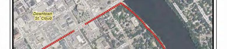
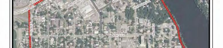
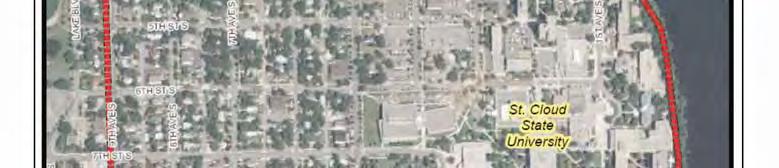
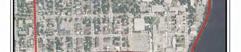
105 Figure 1 Project Location/Neighborhood Boundary South Side University Neighborhood Master Plan University Page A- 16 APPENDIX A TRAFFIC STUDY


106 Figure 2 Existing Transportation Circulation and Traffic Control South Side University Neighborhood Master Plan University Page A- 17 APPENDIX A TRAFFIC STUDY
107 Figure 3 Existing On-Street Parking South Side University Neighborhood Master Plan University Page A- 18 APPENDIX A TRAFFIC STUDY

108 Figure 4 Existing Trail Network South Side University Neighborhood Master Plan University Page A- 19 APPENDIX A TRAFFIC STUDY
109 Figure 5 Existing Transit Service South Side University Neighborhood Master Plan University Page A- 20 APPENDIX A TRAFFIC STUDY


110 Figure 6 Existing A.M. Peak Hour Traffic Volumes and LOS Operations South Side University Neighborhood Master Plan University Page A- 21 APPENDIX A TRAFFIC STUDY


111 Figure 7 Existing P.M. Peak Hour Traffic Volumes and LOS Operations South Side University Neighborhood Master Plan University Page A- 22 APPENDIX A TRAFFIC STUDY
 Volumes South Side")

112 Figure 8 Existing Average Daily Traffic (ADT) Volumes South Side University Neighborhood Master Plan University Page A- 23 APPENDIX A TRAFFIC STUDY


")

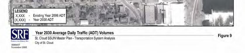
113 Figure 9 Year 2030 Average Daily Traffic (ADT) Volumes South Side University Neighborhood Master Plan University Page A- 24 APPENDIX A TRAFFIC STUDY


114 Figure 10 Year 2030 Do Nothing A.M. Peak Hour Traffic Volumes and LOS Operations South Side University Neighborhood Master Plan University Page A- 25 APPENDIX A TRAFFIC STUDY

115 Figure 11 Year 2030 Do Nothing P.M. Peak Hour Traffic Volumes and LOS Operations South Side University Neighborhood Master Plan University Page A- 26 APPENDIX A TRAFFIC STUDY
116 Figure 12 5th Avenue Concept Alternative Recommendation South Side University Neighborhood Master Plan University Page A- 27 APPENDIX A TRAFFIC STUDY

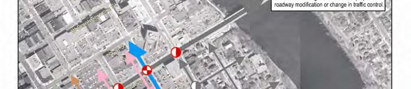
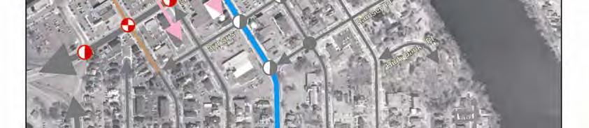
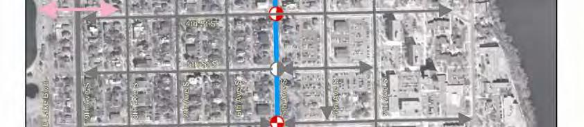
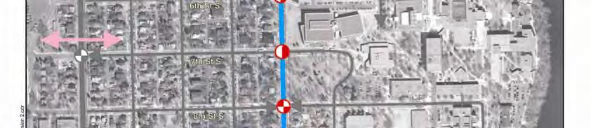
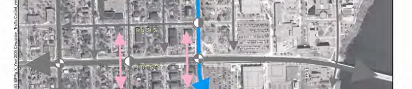
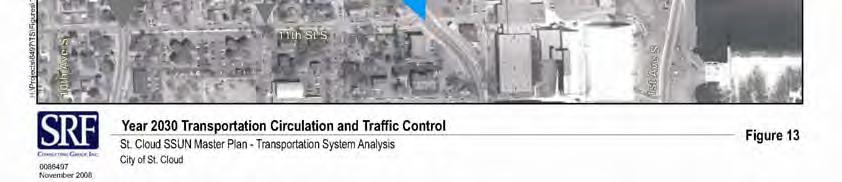
117 Figure 13 - Future Transportation Circulation and Traffic Control South Side University Neighborhood Master Plan University Page A- 28 APPENDIX A TRAFFIC STUDY
118 Figure 14 Future On-Street Parking South Side University Neighborhood Master Plan University Page A- 29 APPENDIX A TRAFFIC STUDY

119 Figure 15 Year th Avenue Modifications A.M. Peak Hour Traffic Volumes and LOS Operations South Side University Neighborhood Master Plan University Page A- 30 APPENDIX A TRAFFIC STUDY

120 Figure 16 Year th Avenue Modifications P.M. Peak Hour Traffic Volumes and LOS Operations South Side University Neighborhood Master Plan University Page A- 31 APPENDIX A TRAFFIC STUDY
121 Figure 17 Proposed Trails South Side University Neighborhood Master Plan University Page A- 32 APPENDIX A TRAFFIC STUDY
122 B APPENDIX URBAN DESIGN STUDY The South Side University Neighborhood Master Plan Urban Design Study was prepared by Geoff Martin, Bonestroo. The purpose of this Urban Design Framework Plan is to illustrate, in a conceptual manner, the intent of the goals and design principles defined by this process for the South Side University Neighborhood.The urban design framework plan is intended to establish specific character districts within the South Side University Neighborhood that enhance the neighborhood s historic assets and establishes gateways for the South Side neighborhood and St. Cloud State University. In addition, the urban design framework defines specific design elements to ensure the compatibility of future redevelopment and public infrastructure projects with the desired character of sub-areas and transition to existing adjacent buildings/uses. This plan will set the foundation to: Establish building and site design standards for mixed use redevelopment that create a pedestrian friendly environment and transition well to surrounding properties and downtown. Define and implement a palette of streetscape elements that establishes a unique sense of arrival for the gateways to the South Side University Neighborhood and St. Cloud State University To this end, the Plan offers a guide for growth that is Flexible and may respond to fluctuating market conditions Ensures that potential growth of both private redevelopment and improvements to the public realm will be orderly, predicable and sustainable, as well as, Integrated into a mutually supportive plan for the neighborhood and SCSU. South Side University Neighborhood Master Plan University NeighPage B-1 APPENDIX B URBAN DESIGN STUDY


123 Captures the opportunities projected in the market in a manner that improves the overall livability of the neighborhood. Improves the pedestrian and bicycle experience to and within the neighborhood by creating pedestrian-friendly streetscapes and by strengthening pedestrian connections with nearby points of interests, open spaces, SCSU and downtown. Works with the transportation improvements to improve mobility, transit facilities, pedestrian, and bicycle safety. This urban design framework illustrates how the physical character anticipated in the land use plan may evolve into a built form. This chapter focuses on the primary components of the framework plan which include: A. Gateways and Streetscape Hierarchy Plan B. Focus Areas: North Mixed Use Urban Village South High Density Infill and Gateway Area C. Neighborhood Streetscape Elements D. Built Form and Development Guidelines Land Use Physical Character South Side University Neighborhood Master Plan University NeighPage B-2 APPENDIX B URBAN DESIGN STUDY


124 Place Making Design Principles This framework plan responds to the unique qualities of the South Side Neighborhood setting and integrates land uses, opens spaces, building massing, pedestrian and bicycle connections, parking, and transportation systems to foster a genuine and memorable place. This plan illustrates how to capitalize on numerous redevelopment opportunities while simultaneously: Creating distinctive gateways to the neighborhood and downtown Clearly defining edges and transitions between the neighborhood and SCSU as well as, potential mixed use development. Balancing vehicular needs with pedestrian safety and comfort Reinforcing the historic character of the district Improving the climate for reinvestment A. GATEWAY AND STREETSCAPE HIERARCHY PLAN The quality, function and scale of the entry experience and the streets have a great deal to do with shaping the character of the South Side Neighborhood. A hierarchy of gateway and streetscape treatments is proposed to respond to the role of each street and gateway within the neighborhood. The hierarchy is illustrated on Figure XX, and is defined as follows: Primary Gateways These streets act as the approach routes and busiest entry points to the South Side Neighborhood. The design of these corridors should signal to motorists they are entering a special district.treatments may include building massing to shape a human scaled corridor, commercial uses that may activate the street, transit facilities, boulevard trees, distinctive lighting, entry monuments, public art, and directional signing. Primary gateways include: 9th Avenue at 10th and 7th St. 5th Avenue at 10th St. & Hwy.23 Secondary Gateways These streets are located at the one-way streets and less traveled points of entry. Treatments may include building massing to shape a human scaled corridor, boulevard trees, distinctive South Side University Neighborhood Master Plan University NeighPage B-3 APPENDIX B URBAN DESIGN STUDY
125 lighting, entry monuments, public art, and directional signing as well as, side walk bump outs and other traffic calming measures. Secondary gateways include: 9th Ave. at 8th, 6th &4th Streets. 7th Ave. at 10thSt. And Hwy 23. South Side University Neighborhood Master Plan University NeighPage B-4 APPENDIX B URBAN DESIGN STUDY

126 Urban Mixed Use Streets These streets serve the primary commercial areas and are intended to foster a dynamic, active urban environment. Development fronting these streets should reinforce an urban pattern with building placed up to the sidewalks and parking to the side or rear. These streets are intended to receive the most intense streetscape treatments which may include wide sidewalks with bump outs, street trees, pedestrian scaled lighting decorative paving, benches, parking lot buffers, planting areas, kiosks, banners, public art, and a coordinated signing system. 5 th Avenue: Focus of Commercial, Pedestrian, Transit, and Cultural Activity One of the objectives of the neighborhood framework is to improve the connection between the neighborhood, SCSU and Downtown. 5 th Avenue will become one this primary link and should provide, through building massing, architecture, streetscape treatments and land uses, a dynamic pedestrian scaled link from he neighborhood to Downtown. To improve this important connection 5 th Avenue north of 4 th Street is proposed to include 3 to 6 story mixed use buildings up to the street, active storefronts, wide sidewalks, on street parking, street trees, sidewalk bump outs where possible, highlighted cross walks, pedestrian scaled light fixtures, transit facilities, decorative paving, benches, parking lot buffers, planting areas, information kiosks and /or wayfinding elements (See figure ) 5 th Avenue South of 4 th Street is the primary entry corridor to both the neighborhood and SCSU. Challenges for this segment include creating a distinction between the neighborhood and SCSU Campus, defining a green edge to the campus, pedestrian and bicycle safety, and improving transit facilities. The transportation chapter of this document addresses the functional solutions to vehicular movements, pedestrian safety, transit, and bicycle objectives. Qualitative improvements to the streetscape and transit facilities are outlined later in this chapter. As of this writing, SCSU is in the process of updating the campus master plan. It is our understanding the University is considering potential buildings back from 5 th Avenue to reflect the residential setback to the west and also to maintain a green edge to the campus. It is also our understanding the University is exploring new palette of streetscape elements for use throughout the campus that are distinctly different from those proposed for the neighborhood outlined in latter sections of this chapter. South Side University Neighborhood Master Plan University NeighPage B-5 APPENDIX B URBAN DESIGN STUDY
127 Residential Streets: Interconnecting the Neighborhood to SCSU and Downtown Currently, the historic quality of the residential neighborhoods is complemented by a grid of human scaled, tree lined streets with generous boulevards and sidewalks. Treatments for these streets should reinforce the traditional neighborhood character by maintaining the tree canopy, defining a complimentary palette of streetscape elements including lights, benches, trash receptacles, historical interpretive markers, and bicycled facilities. These minimal treatments may be augmented by exploring the use of sidewalk bumpouts to define traffic lanes, shorten crosswalks and provide space for trees and other landscape materials. B. FOCUS AREAS North Mixed Use Urban Village This district plays many roles within the city and the neighborhood. The land use plan designates the area north of 4th street to Highway 23 as a mixed use urban village that provides an active place that brings people together and serves residents, students and visitors. The 4 blocks fronting Highway 23 will define the north edge of the neighborhood as well as, the entry experience for motorists to the city. The primary connections between downtown, South Side neighborhood and SCSU will be along 5th and 7th Avenues across Highway 23. The placement, scale and character of buildings is the most important component of the built environment that will shape this district and determine its long term success as an ainviting destination with strong businesses, human scale, vibrant sidewalks and an attractive place for investment. The intent is to reinforce a compact urban development pattern with welldesigned, attractive, functional, safe buildings that reinforce a distinct identity. The framework plan illustrates the following key objectives for this area: Land Use Transitions and Built Form The primary design objective is for new development to fit into its surroundings and respond to neighborhood transitions with building massing and architecture. 1. Infill and concentrate density and active storefronts primarily along 5th and 7th Avenues to shape these gateways to the neighborhood and connections to Downtown. 2. Buildings should step down from 4 to 6 stories along Highway 23 to a maximum of 3 stories or 35 ft. to meet the existing neighborhoods along 4th Street, Ramsey Place and 4th Avenue. South Side University Neighborhood Master Plan University NeighPage B-6 APPENDIX B URBAN DESIGN STUDY

128 North Mixed Use Urban Village: Highway 23 looking south 3. Encourage mixed use redevelopment buildings to include active store fronts and wide sidewalks. 4. Reinforce this gateway district by framing Highway 23, 5th Avenue and 7th Avenue, with signature buildings. Potential Building Massing along Highway 23 Corridor South Side University Neighborhood Master Plan University NeighPage B-7 APPENDIX B URBAN DESIGN STUDY


129 Building Massing Shape 5 th Avenue Gateway & Connection Streetscape 5. Improve traffic movements by consolidating access points and development parcels, and encouraging shared parking. 6. Due to limited ROW, particularly along Highway 23, New buildings should have a build-to line a minimum of 14 feet from the street curb to provide more sidewalk space. 7. Encourage the use of arcades to expand the sidewalk width while maintaining development potential. Highway 23: Limited R.O.W. 5th Avenue South Side University Neighborhood Master Plan University NeighPage B-8 APPENDIX B URBAN DESIGN STUDY

130 Incorporate Arcades or widen Sidewalk on Hwy. 23 & 5 th Avenue Parking One of the key objectives of this plan is to provide a convenient and adequate parking supply without allowing it to dominate the streetscape. The overall intent is to seek creative opportunities to meet parking requirements by consolidating parking into efficient shared underground or structured parking facilities, as well as maintaining on street parking in front of businesses. Parking is one of many means to access this district and an important transitional experience from driver to pedestrian. For this reason it must be strategically positioned to reinforce pedestrian and vehicular circulation patterns well signed. Recommendations 1. Maintain on-street parking. Encourage shared parking practices between complimentary uses which could allow for better utilization of larger lots. Encourage property owners to combine parking lots in the rear of their buildings and to connect them to side streets allowing for the reduction of curb cuts, the addition of on-street parking, and minimizing of left turn movements. Promote the use of alternative modes of transportation to reduce the need for excessive parking. 5. Encourage parking structures to be on the interior of the block and visually integrated with the architecture. 6. Where possible, liner uses should be considered to hide parking structures and encourage active uses on the street level. 7. Buffer surface parking lots from public view through the use of trees, shrubs, railings, walls and/or a combination of these elements. 8. Consider public District Parking structures to serve multiple needs. South Side University Neighborhood Master Plan University NeighPage B-9 APPENDIX B URBAN DESIGN STUDY


131 7th Avenue: Secondary Gateway at Hwy 23 4th Avenue Transition 4th Street Transition 7th & 6th Avenue Transitions Existing 5th Avenue Commercial District Ramsey Place to Highway 23 South Side University Neighborhood Master Plan University NeighPage B-10 APPENDIX B URBAN DESIGN STUDY

132 Proposed Mixed Use District : Building Massing Steps down to Neighborhoods South Side University Neighborhood Master Plan University NeighPage B-11 APPENDIX B URBAN DESIGN STUDY


133 South End Framework Plan This district plays many roles within the city and the neighborhood. The 4 blocks fronting University Drive define the south edge of the neighborhood as well as, the primary access and gateway to SCSU at 5 th Avenue The land use plan designates the area between 9 th and 10 th Street and 5 th Avenue to 8 th Avenue as a high density residential redevelopment area. The block at the north east corner of 9 th Avenue and 10 th Street marks the southeast gateway to the neighborhood and is planned for commercial/mixed uses. As of this writing, a transportation study of University Drive is being conducted to determine alternatives for the street design to manage the traffic capacity projected to the year One consideration is a roundabout at 5 th Avenue. This alternative could be a significant gateway feature for both the neighborhood and SCSU. Primary Gateway: 5th Avenue and 10th Street South Side University Neighborhood Master Plan University NeighPage B-12 APPENDIX B URBAN DESIGN STUDY
134 Balancing SCSU and Neighborhood Gateway Treatments The framework plan illustrates the following key objectives for this area: Land Use Transitions and Built Form The primary objective is to design new development to fit into its surroundings and respond to neighborhood transitions with building massing and architecture. The intent is to reinforce the district identity by infilling where possible with a compact traditional neighborhood development pattern. 1. Infill with housing that follows the traditional residential building pattern with buildings up to the predominate setback and parking in the rear or side yard. 2. Buildings should step down from 4 to 6 stories along University Drive to a maximum of 3 stories or 35 ft. to meet the existing neighborhoods along 9th and 8 th Streets. 3. Define the southeast gateway by encouraging 2 to 4 story mixed use signature buildings at the corner of 9 th Avenue and University Drive. New buildings should have a build-to line a minimum of 14 feet from the street curb to provide more sidewalk space 4. Reinforce 5 th Avenue with infill housing built up to the current residential setback. 5. Improve the character of existing parking areas by buffering views from public streets with more trees, hedges, perennial beds, rain gardens, etc. 6. Provide a neighborhood park and medium density housing on the Washington School site. South Side University Neighborhood Master Plan University NeighPage B-13 APPENDIX B URBAN DESIGN STUDY


135 Primary Gateway: 10th Street and 9th Avenue Building Massing Shapes Gateway at 10th Street and 9th Avenue Land Use Transition at 9th Street South Side University Neighborhood Master Plan University NeighPage B-14 APPENDIX B URBAN DESIGN STUDY


136 C. NEIGHBORHOOD STREETSCAPE ELEMENTS The combination, quality, function and scale of the streetscape elements have a great deal to do with shaping the character and identity of the SSUN. A goal of the framework plan is to define a preliminary palette of elements to consider for the streetscape that will reinforce the historic qualities of the neighborhood. These elements could be used throughout the residential and mixed use streets as well as, to highlight gateways and transit facilities. Provide Continuity, Flexibility and Ease of maintenance The elements should provide continuity throughout the neighborhood, yet be adaptable to varying site conditions and establish an armature for layers of change and activity. Vertical streetscape elements should be emphasized such as lighting, trees, bus shelters, identification signs, and artwork, to create a sense of enclosure and human scale, define edges, and create a positive identity for the neighborhood. Elements should be functional and simple in design and able to withstand the snow, salt, sandblasting from snow plows, vandalism, and other urban conditions. The streetscape elements should contribute to a sense of safety and comfort and promote walking and biking throughout the neighborhood. Existing Elements The historic quality of the residential neighborhoods is complemented by a grid of human scaled, tree lined streets with generous boulevards and sidewalks. In many areas the boundary between public and private space is effectively shaped by defined slopes at the edge of the walkways. Historic looking acorn lights with fluted poles are used throughout the historic district. Discreet small brown signs are also located on poles at throughout the historic district. South Side University Neighborhood Master Plan University NeighPage B-15 APPENDIX B URBAN DESIGN STUDY


137 A few remnants of granite rubble walls built back at the turn of the century may still be found in the neighborhood, Barden Park, and throughout the City. These granite walls recall the bedrock of the region and the historical reference to St. Cloud as the Granite City. More refined uses of granite can be found on the SCSU campus at Skalicky Plaza and on other monuments and buildings. Yellow brick used to be manufactured out of native clays from the 1880s up to the 1930s and may be found on several of the homes in the South Side Neighborhood. This is another material to consider for use in monuments, walls, benches and other streetscape elements. Boulevards, Street Trees, Walks and Slopes Granite Walls Bus Shelters Existing Neighborhood Streetscape Elements South Side University Neighborhood Master Plan University NeighPage B-16 APPENDIX B URBAN DESIGN STUDY


138 Existing SCSU Streetscape Elements South Side University Neighborhood Master Plan University NeighPage B-17 APPENDIX B URBAN DESIGN STUDY


139 Alternative Palettes Two preliminary concepts were prepared to illustrate how the historical qualities of the neighborhood could be reinforced through a palette of streetscape elements. Concept A utilizes the granite rubble texture for entry monuments, seat walls, interpretive signs, light and kiosk bases, and bus shelter supports. Concept B utilizes the rustic granite blocks for entry monuments, seat walls, interpretive signs, light and kiosk bases, and bus shelter Streetscape Concept B Elements South Side University Neighborhood Master Plan University NeighPage B-18 APPENDIX B URBAN DESIGN STUDY


140 Following is an outline of some of the basic elements to consider District Monuments Locate at Primary Entry Points & Transit Stops Reinforce Neighborhood Identity Pedestrian Crossings Contrasting decorative paving, enhanced lighting, imbedded pavement lighting, and crosswalk signal timing should be considered to improve the pedestrian crossings. Transit Stops The transit stops are one of the most active pedestrian gathering spaces and identifying elements within the neighborhood streetscape and should be designed to be more comfortable and dignified to attract more ridership. The stops can be enhanced with the use of new shelters, kiosks, monument signs, decorative paving, newspaper corrals, and public art.. Sidewalk Treatments Several options exist for sidewalk paving materials decorative concrete treatments, concrete pavers, exposed aggregate concrete, brick and stone and/or several combinations of these materials. One approach is to use a simple, economical pattern and material in the less traveled areas and a more intense use of decorative materials and patterns in special gathering areas, entry points, and bus stops. Lighting Provide both Street and Pedestrian Level Lighting Wayfinding Signs & Kiosks A cohesive system of wayfinding signs and kiosks should be considered to help direct visitors to public parking, institutions, amenities, and other places of interest throughout the neighborhood as well as inform them about community events, history, and other items of interest. Plant Materials Plant materials should be selected based on their ability to survive the urban conditions of snow, salt, drought, and in some areas, compacted and alkaline soils. Seasonal interest, form and texture are also considerations. In the commercial areas, overstory trees could be clustered to maintain visibility to shops and signs and to avoid a regimented appearance. Clustering also facilitates the creation of large South Side University Neighborhood Master Plan University NeighPage B-19 APPENDIX B URBAN DESIGN STUDY


141 beds of uncompacted modified soil to promote plant vitality. Where possible, trees should be located between the curb and sidewalk to create an edge between pedestrian and vehicular zones and to help create a sense of enclosure to the street and sidewalks. Street Furniture The benches and trash receptacles should be chosen based upon of their compatibility with the overall design theme, ease of maintenance, recycling collection, and durability. Parking Lot Edge Treatments One of the objectives of the streetscape is to provide solutions for the treatment of parking lot edges that are flexible and may adapt to a variety of site conditions and budget constraints. To enhance the image of the area, parking lot buffers are proposed along all the parking lot frontage. The buffers can be a combination of low walls or decorative railings, hedges and trees. Public Art and Interpretive Elements Consideration should be given to incorporating public art created by local or regional artists to enrich the streetscape. Interpretive elements such as a Linear Library could be included to emphasize unique aspects of the Neighborhood's history, icons, people and spirit of the place, and could be integrated into the design of gateways, district monuments, signs, kiosks, paving, bike racks, medians, and/or gathering places or transit stops. South Side University Neighborhood Master Plan University NeighPage B-20 APPENDIX B URBAN DESIGN STUDY


142 Gateway Treatments Several concepts have been prepared for the Primary and Secondary Gateways to illustrate how the streetscape components could be used to achieve the design objectives. 6 th Street: Typical Secondary Gateway at One Way Streets 6th Street Typical: 30 ft. curb to curb, 60 ft. ROW, Parking on North Side. 8 ft. Blvd. & 6 to 7 ft. Walks Concept A: Includes Bump out on north side with parking lane, Lights to frame entry, New Neighborhood Identification Signs on Lights, Colored Concrete Nodes and Crosswalks, Boulevard Trees, South Side University Neighborhood Master Plan University NeighPage B-21 APPENDIX B URBAN DESIGN STUDY
143 Concept B: Includes Stone Monument, Colored Concrete Nodes and Crosswalks, Bump out on North Side, Lights, Boulevard Trees Concept C: Includes Bump outs on both sides, Parking on both sides, Stone Seat Walls & Light Bases, Colored Concrete Nodes and Crosswalks South Side University Neighborhood Master Plan University NeighPage B-22 APPENDIX B URBAN DESIGN STUDY


144 Secondary Gateway 7th Ave. at 10thSt. Existing : 36ft. Wide curb to curb, 8 to 9ft. Blvd. 6ft. Walks, 66ft. ROW Concept D: Includes Bump outs on both sides, Parking on both sides, Public Art / Stone Sculptures, Colored Concrete Nodes and Crosswalks South Side University Neighborhood Master Plan University NeighPage B-23 APPENDIX B URBAN DESIGN STUDY


145 Primary Gateway: 9th Avenue at 7th Street Existing: Two-way, 32ft. curb to curb, No Parking Proposed improvements: Small bump out, Gateway Sculptures/Monuments Lights, Improved Crosswalks, single arm traffic control lights painted black. South Side University Neighborhood Master Plan University NeighPage B-24 APPENDIX B URBAN DESIGN STUDY


146 Primary Gateway: 5th Avenue and 9th Street Existing Bus Stops Proposed Bus Stop Improvements: Parking buffers, new shelters, public art. Decorative paving. South Side University Neighborhood Master Plan University NeighPage B-25 APPENDIX B URBAN DESIGN STUDY
147 D. BUILT FORM AND DEVELOPMENT GUIDELINES A goal of the South Side neighborhood plan is to establish a high standard of building design that compliments surrounding properties and enhances the desired character of the South Side University Neighborhood. A second goal is to establish minimum site design standards related to parking, refuse collection, and other considerations that enhance the appearance of the South Side University Neighborhood. Ultimately new design standards will become the foundation of a new overlay district which will include heightened standards for building design and materials, as well as massing and building placement for those areas suggested for multiplefamily redevelopment by the Master Plan s land use & redevelopment framework plan. Currently, the Residential Historic District Preservation Design Manual sets forth design guidelines for buildings within the historic district. This document defines guidelines primarily for renovations of existing residential historic structures. A new overlay district should augment this document by providing more specific standards for site design and new mixed use and multiple residential buildings. In general, new buildings within the South Side Neighborhood mixed use and High Density Multiple residential areas should provide interest at the street level, create interesting street corners, demonstrate the use of high quality materials, compliment the historic character of the area, and enhance the overall pedestrian experience on the street. This Framework recommends as a minimum guidelines for: Site Design and Building Massing Façade Treatments Ground Level Expression Signs Roof Design Parking Lot Edge Treatments Parking Structures South Side University Neighborhood Master Plan University NeighPage B-26 APPENDIX B URBAN DESIGN STUDY

148 Site Design The placement of buildings along South Side Neighborhood streets has a profound effect on the character of the pedestrian environment. Buildings in the mixed use areas should be placed close to the right-of-way, with primary entrances facing the street. Buildings should be placed on corners at street intersections to emphasize and define those intersections. Any parking and service uses should be placed behind or to the side of buildings. By maintaining a mostly continuous line of buildings along the sidewalk edge, pedestrians will use, and therefore enliven, the streets in the gateway areas. South Side University Neighborhood Master Plan University NeighPage B-27 APPENDIX B URBAN DESIGN STUDY


149 New residential buildings within the low density traditional neighborhood areas should follow the traditional residential development pattern with buildings facing the street and parking /service areas off the alley in back. Mixed Use Parking Lot Edge Treatments Parking lot frontage on the primary pedestrian streets should be a maximum of 80 feet. this dimension allows for a double loaded aisle of 90 degree parking with walks and green space. The edges and interiors should be extensively greened. Hedges, ornamental railings, bollards, trees, and other methods should be used to buffer the view to parking lots from the public realm. Facade Treatments South Side University Neighborhood Master Plan University NeighPage B-28 APPENDIX B URBAN DESIGN STUDY

150 Commercial/mixed use buildings should have a well defined base, middle and top. The base or ground floor should appear visually distinct from the upper stories through the use of a change in building materials, window shape or size, an intermediate cornice line, awning, arcade or portico, or similar techniques. The base or ground floor of the building should include elements that relate to the human scale, including texture, projections, doors, windows, awnings, canopies or ornamentation. Distinct modules The primary facade(s) of buildings of 40 feet or more in width should be articulated into smaller increments through use of different textures, division into storefronts with separate display windows, ornamental features such as arcades or awnings, or by division of the building mass into several smaller segments. Ground Level Expression Ground level expression refers to the way in which a building meets the street. This building/pedestrian interface is a crucial part of urban design and should provide visual interest, opportunities for sociability, and overall pedestrian safety and comfort. As stated above, windows and clear entrances enhance a building s appearance on the street, and may be further augmented by awnings, pocket plazas, outdoor cafe seating, and plantings. South Side University Neighborhood Master Plan University NeighPage B-29 APPENDIX B URBAN DESIGN STUDY


151 Signs Signs in pedestrian areas should address the scale of the pedestrian, should be simple in materials and message, and enhance the overall street environment. This is not to say that signs cannot be colorful, unusual, or noticeable in fact, interesting signs can add a memorable dimension to a commercial area. In essence, signs should effectively communicate the character of the business they advertise without overwhelming the pedestrian streetscape. Roof Design A building s roof line can establish its individuality and interest within the context of the neighborhood, and variety in roof lines from building to building can add visual interest to a mixed use area. Some techniques that add interest include varying heights and cornices within an otherwise unified design scheme, using roof line changes to note entrances or commercial bays, and establishing contrasting roof lines at street corners. Franchise Architecture Chain establishments typically desire a specific architectural motif, in order to emphasize consistency in their network and attract regular customers. In many cases, this standardized architecture conflicts with an historic urban core. There are ways, however, of incorporating the franchise s desired signage and even some building treatments, while still encouraging the basic principles of commercial building design listed above. Franchise establishments should still address the street with windows, prominent entrances, and unique corner treatments. South Side University Neighborhood Master Plan University NeighPage B-30 APPENDIX B URBAN DESIGN STUDY


152 Residential Parking / Service Areas Many driveways within the traditional neighborhood areas have been expanded into parking lots to accommodate more rental units. Many of these parking areas are paved up to the sidewalks leaving little distinction between public and private space as well as unsightly views parking lots and dumpsters. As with the mixed use parking areas, residential parking and service areas should be buffered from view The following examples illustrate cost effective solutions to buffer residential parking/service areas. Parking / Service Areas Landscape Buffer: Stone/Brick, Perennials & Trees Landscape Buffer: Stone/Brick, Perennials & Trees, & Hedge South Side University Neighborhood Master Plan University NeighPage B-31 APPENDIX B URBAN DESIGN STUDY

153 Multiple Residential Building Types Residential buildings may take different forms, such as townhomes and condominium or apartment buildings, but should always be constructed of high quality materials, demonstrate a unified design theme, and possess various roof lines and a clear but approachable differentiation between public and private space. They should also include interior parking and open spaces, in order to provide residents opportunities to access the buildings and relax outdoors sheltered from the street. Possible Multiple Residential building types for the SSUN South Side University Neighborhood Master Plan University NeighPage B-32 APPENDIX B URBAN DESIGN STUDY

154 Mixed Use Building Types and Parking Structures Commercial buildings should address the street, providing windows and access points to create interest and draw users. Adaptive re-use is encouraged, as it preserves and enhances the historic character of South Side Neighborhood. Multi-level and mixed use buildings also add significant benefit to the gateway area, as their mass helps to define and frame the street. Unique treatments at street corners and a unified, high quality, design scheme are also encouraged. Figure ---- illustrates examples of mixed use building types that would be appropriate for the South Side Neighborhood designated redevelopment areas. Possible mixed use building types for the SSUN South Side University Neighborhood Master Plan University NeighPage B-33 APPENDIX B URBAN DESIGN STUDY


155 Foster Environmental and Economic Sustainability Integrate the principles of smart growth, urbanism, and green building to create a sustainable redevelopment plan. Include low impact storm water treatments such as, micro basins, rain gardens, street tree filters, permeable pavements, depressed parking lot islands Green Roofs, Cradle to Cradle Materials, Energy Efficient.. Meet minimum standards for LEED New Buildings and Neighborhood Design South Side University Neighborhood Master Plan University NeighPage B-34 APPENDIX B URBAN DESIGN STUDY
 Analysis. During the analysis, the neighborhood s assets, challenges and desired outcomes were identified.")
156 C APPENDIX COMMUNITY VISIONING RESULTS 2005 HEALTHY NEIGHBORHOODS PARTNERSHIP PROGRAM In 2005, South Side University Neighborhood residents participated in the Healthy Neighborhoods Partnership Program Strengths, Weaknesses, Opportunities and Threats (SWOT) Analysis. During the analysis, the neighborhood s assets, challenges and desired outcomes were identified. NEIGHBORHOOD ASSETS Historic/Quality Homes and Close Proximity to Parks and Lake George were defined as the top assets of the South Side University Neighborhood by participants of the 2005 SWOT Analysis. The following shows the number of votes each asset received during the SWOT: Assets Votes Assets Votes Historic /Quality Homes 8 Historic District Status 4 Close to Parks/Lake George 8 Organized Neighborhood Status 3 Good Neighbors 7 New Infrastructure 3 Faith Community 7 Affordable/Mix of Housing 2 Walking 7 Public Transportation 2 Near Mississippi River 7 Pride in Ownership 1 Diversity 7 Active Neighborhood Association 1 Location 7 Safe/Clean Neighborhood 1 Cultural Events 7 Good Place to Raise Children 1 Proximity to Schools 7 Munsinger/Clemens Gardens 1 Feeling of Energy 6 Architectural Diversity 1 Coborn s 6 Some Quiet Locations 1 Mature Greenspace 5 Neighborhood Appearance 1 South Side University Neighborhood Master Plan UniverPage C- 1 APPENDIX C COMMUNITY VISIONING RESULTS
157 NEIGHBORHOOD CHALLENGES Deteriorating Properties, Noisy Bar Crowds and Transportation, and Increased Traffic were defined as the top challenges of the South Side Neighborhood by the 2005 SWOT. The following shows the number of votes each challenge received during the SWOT: Challenges Votes Challenges Votes Deteriorating Properties 8 Arson Issues 3 Noisy Bar Crowds/Transportation 8 High Property Density 3 Traffic 8 No Regular Police Control 3 Rental % Too High 7 Students Feel it is Their 3 Neighborhood Excessive Alcohol Use 7 Too much light pollution 2 Lack of On-Street Parking 7 Unsafe for Children/Others 2 Trash/Litter/Discarded 7 Lack of Response by SCSU for Off- 2 Furniture/Lack of Recycling Campus Students Move-In Day/Homecoming 6 Paved Over Yards 2 Vandalism 6 Lack of Lighting 2 Transitional/Short-Term Residents 6 Losing Sense of Community 2 Quality of Rental Management 6 Failure to Utilize Mississippi River as 2 an Asset Crime is Up 5 No Elementary School 1 Poor Ordinance Enforcement 4 Unknown/Unpredictable Future 1 Loss/Lack of Family-Owned 4 Lack of Good Public Relations in 1 Businesses Selling Homes Harassment/Retaliation of 4 Lack of Police Protection During Bar 1 Homeowner by Renters Close Inflated House Prices 4 HPC Need To Be More Strict 1 Difficulty Crossing the Busy Streets 4 Bike Path Ends at Stairs 1 Drug Issues 4 Can be a Judgmental Neighborhood 1 Theft 4 HPC Rules Too Strict 1 Law Encourages Rental Over 3 Lack of Street Signs 1 Owner-Occupied Challenges with no votes: Intolerance towards minorities Better Grocery Store Needed Disrespect for yards Too Much Political Clout for Bar Owners Condition vs. cost of housing Homeless issue South Side University Neighborhood Master Plan UniverPage C- 2 APPENDIX C COMMUNITY VISIONING RESULTS
158 TOP FIVE DESIRED OUTCOMES Better Enforcement of Ordinances, More Homesteaders vs. Rentals, Improved Maintenance of Property, Increased Cooperation with SCSU and Better Relationship for all Stakeholders were defined as the top five desired outcomes of the 2005 SWOT. The following shows the number of votes each outcome received during the SWOT: Outcomes Votes Outcomes Votes Better Enforcement of Ordinances 22 Beautification/Clean-Up 3 More Homesteaders vs. Rentals 16 Cap Enrollment at SCSU 2 Improved Maintenance of Property 12 More parking for campus 2 Increased Cooperation w/ SCSU 11 More responsibilities for landlords 2 (Student Behavior) Better Relationship for all 8 Retain Coborn s 2 Stakeholders More Incentives for Property 6 Friendlier bike/walking paths 2 Rehabilitation Complete Restoration of Barden 5 Eliminate gang problems 2 Park More Neighborhood Gatherings 5 Strengthen Neighborhood Historic 1 Districts Retain and Recruit Businesses 4 Better use of the Mississippi River 1 5 th Ave. Small Business District 4 Better coordination/responsibility (by 1 SCSU) for Homecoming Day Better Resident Parking 3 Neighborhood public relations plan 1 Noise Reduction 3 Fewer chain businesses 1 Review/Change Zoning 3 Better technology for safety/security 1 Upgrade Safety 3 Outcomes with no votes: Phase out rooming houses by 2010 Better street lighting More on-campus housing Increase Historic District size Slow down rentals South Side University Neighborhood Master Plan UniverPage C- 3 APPENDIX C COMMUNITY VISIONING RESULTS
159 2008 NEIGHBORHOOD VISIONING ACTIVITIES On February 20, 2008, approximately 200 South Side University Neighborhood residents participated in a Community Input session to offer input for the South Side University Neighborhood Master Plan and assist the 5 th Avenue redevelopment team regarding the design and issues related to the proposed 5 th Avenue redevelopment (former Coborn s site). The session was comprised of the following stations 1. Land Use Planning Coloring Activity 2. Neighborhood Amenities Location Maps 3. Review of Existing Neighborhood Data 4. Visual Preference Survey 5. Neighborhood-Means-to-Me Survey 6. Issues Map Activity 7. Heritage Preservation STATION 1. LAND USE The Land Use Station was a coloring activity that allowed participants to give their input as to how land in their neighborhood should be used. Participants showed, through the use of colors (yellow indicates Single Family, orange indicates Multiple Family, red indicates Commercial, and green indicates Park), how their neighborhood should be zoned. The images to the right shows compilation of desired land use maps that were created by participants of this activity. Summary The majority of the maps showed: Extension of commercial use on 5 th Avenue, but southern terminus varies significantly Preservation (existing) and return of single family homes for owner occupancy Multiple-family redevelopment in appropriate locations (close to campus and University Drive) Green corridors and maintain park Define campus edge to the west South Side University Neighborhood Master Plan UniverPage C- 4 APPENDIX C COMMUNITY VISIONING RESULTS


 Student entertainment facility")


160 Summary of Desirable Land Uses: Bookstore Deli Coffee shop Whole foods market Ethnic market Grocery store Ethnic restaurants Non-franchise Bakery Ice cream shop Video store Jamba Juice High-end liquor store (Wine only) Student entertainment facility (no alcohol) Student-only areas Community activity center Parks/open space SCSU President/professor housing Eliminate all rooming houses by 2010 Outdoor ice arena South Side University Neighborhood Master Plan UniverPage C- 5 APPENDIX C COMMUNITY VISIONING RESULTS


161 STATION 2. NEIGHBORHOOD AMENITIES The Neighborhood Amenities Station allowed participants of this visioning session to give their input as to where neighborhood amenities such as street name signs, bollards, entry monuments, trees, planters, streetlights, benches, trash receptacles and bicycle racks should be placed throughout the neighborhood. The images below show the four neighborhood amenities maps that were created by participants of this activity. South Side University Neighborhood Master Plan UniverPage C- 6 APPENDIX C COMMUNITY VISIONING RESULTS
162 STATION 4. VISUAL PREFERENCE SURVEY The Visual Preference Survey Station allowed participants to give their input on designs of the following neighborhood amenities: street and sidewalk materials, street name signs, bollards, entry signs, street trees, planters, streetlight designs, bench designs, trash receptacles, bicycle racks, neighborhood character builders and redevelopment character. The following pages show the results of the Visual Preference Survey. The number to the left of each neighborhood amenity indicates the rating it received from survey participants on a scale from one to six, one being the least desirable design and six being the most desirable design. South Side University Neighborhood Master Plan UniverPage C- 7 APPENDIX C COMMUNITY VISIONING RESULTS
163 South Side University Neighborhood Master Plan UniverPage C- 8 APPENDIX C COMMUNITY VISIONING RESULTS

164 South Side University Neighborhood Master Plan UniverPage C- 9 APPENDIX C COMMUNITY VISIONING RESULTS

165 South Side University Neighborhood Master Plan UniverPage C- 10 RESULTS APPENDIX C COMMUNITY VISIONING

166 A South Side University Neighborhood Master Plan UniverPage C- 11 RESULTS APPENDIX C COMMUNITY VISIONING

167 South Side University Neighborhood Master Plan UniverPage C- 12 RESULTS APPENDIX C COMMUNITY VISIONING

168 South Side University Neighborhood Master Plan UniverPage C- 13 RESULTS APPENDIX C COMMUNITY VISIONING
169 South Side University Neighborhood Master Plan UniverPage C- 14 RESULTS APPENDIX C COMMUNITY VISIONING
170 South Side University Neighborhood Master Plan UniverPage C- 15 RESULTS APPENDIX C COMMUNITY VISIONING
171 South Side University Neighborhood Master Plan UniverPage C- 16 RESULTS APPENDIX C COMMUNITY VISIONING

172 South Side University Neighborhood Master Plan UniverPage C- 17 RESULTS APPENDIX C COMMUNITY VISIONING
173 STATION 5. NEIGHBORHOOD MEANS TO ME The Neighborhood-Means-to-Me Station allowed residents to identify the five characteristics that best characterize an ideal neighborhood. The following summary lists the results of this activity: Votes I could walk to a neighborhood market, bookstore, coffee shop, etc. 40 My streets would be safe and well-lit 37 I would have direct access to natural amenities (lakes, nature preserves, etc.) 31 There would be connections to walking/bike paths 22 I could walk to a park 20 I could walk to, or would live in close proximity to public or cultural facilities (library, swimming pool, 19 museum, etc.) Homesteaders in more existing homes 18 I would know my neighbors 17 I could easily access public transit (bus, LRT, train, etc.) 16 I could park on the street 13 I could walk to, or would live in close proximity to work/school 13 There would be lots of trees 12 There would be a diverse mix of people (ethnicity, income, age, etc.) 10 It would be very easy to cross busy streets 9 There would be a diverse mix of housing types (rental, townhomes/condos, and single family) 7 I could walk safely and directly to other neighborhoods 7 My children could walk to school 6 I would live in close proximity to entertainment opportunities (movie theaters, sports facilities, etc.) 6 I could walk to, or would live in close proximity to, personal services (dentist, hair stylist, gym, etc.) 6 There would be a lot of neighborhood activity throughout the day 4 There would be a variety of churches 4 Expand the South Side Neighborhood Historic District south of 6 th St. So. 4 My house would be close to my neighbor s house 3 I would live in close proximity to large retail shopping opportunities 2 I would live in close proximity to city emergency services (police, fire, etc.) 1 There would be easy and direct access to major vehicle arteries 1 Historic District 0 Keep it pedestrian friendly 0 South Side University Neighborhood Master Plan UniverPage C- 18 RESULTS APPENDIX C COMMUNITY VISIONING


174 STATION 6. NEIGHBORHOOD ISSUES MAP ACTIVITY The Neighborhood Issues Map Activity allowed participants to identify issues in the South Side Neighborhood and give suggestions. The following map shows issue areas according to and suggestions given by participants of this activity. Summary Confirmation of neighborhood Assets and Challenges initially established during 2005 Healthy Neighborhoods Partnership Program Assets still are historic homes, Barden Park and other park(s), river and lake, good neighbors, faith community, walkable, diverse, location by downtown and SCSU, cultural events, mature trees, organized neighborhood, mix of housing Challenges still are property condition, noise, traffic, excessive alcohol use, onstreet parking, vandalism, safety, fewer owners, density, code enforcement, litter/trash, no schools, New issue is conflicting values and interests. Improve traffic safety on 5th Ave. So. Improve pedestrian and bike access at 5th Ave. So., Division St., 6th Ave. So., Mississippi River, and in Downtown Commercial redevelopment along 5 th Ave. So. Residential redevelopment for ownership east of 5th Ave. So. Preserve historic homes in Highbanks and throughout area by rezoning and historic district expansion Improve trail connections to Mississippi River, Barden Park, ice rink, riverfront overview sites Continue Barden Park enhancements Historic neighborhood gateways Create SCSU gateways at Division St., University Dr., 5th Ave. So., and 7th St. So. South Side University Neighborhood Master Plan UniverPage C- 19 RESULTS APPENDIX C COMMUNITY VISIONING


175 STATION 7. HERITAGE PRESERVATION The Heritage Preservation Station explained the purpose of the St. Cloud Heritage Preservation Commission, the boundaries of the South Side Neighborhood Historic District and Barden Park Historic District, year built of structures per parcel, the impacts of local historic district designation. Participants were given an opportunity to ask questions about heritage preservation and the implications of historic designation. Additionally, participants could suggest properties in the South Side University Neighborhood that should become designated historic properties and if/how the current historic district should be expanded. The image to the right illustrates the suggested expansion area of the current South Side Neighborhood Historic District. The area outlined in green is the current boundary Historic District. Summary Interest in expansion of existing historic districts; expand to University Drive and 9th Ave. So. and expand to corner of 9th Ave. So. and Division St. Celebrate neighborhood s historic homes Strengthen rules regarding home demolition Reoccupy homes with home owner occupants Identify other means to maintain historic homes South Side University Neighborhood Master Plan UniverPage C- 20 RESULTS APPENDIX C COMMUNITY VISIONING
SECTION ONE: INTRODUCTION. introduction
 introduction 1 INTRODUCTION Since it was first established in 1843 as a trading post for the Hudson s Bay Company, Victoria has evolved into a Provincial capital city that is recognized across Canada and
The Five Components of the McLoughlin Area Plan
 The Five Components of the McLoughlin Area Plan This documents contains the complete language of the five components of the McLoughlin Area Plan: The Vision Statement The Values The Guiding Principles
TEMPLE MEDICAL & EDUCATION DISTRICT
 City of Temple, Texas TEMPLE MEDICAL & EDUCATION DISTRICT 1 Description. The City of Temple joined in partnership with key public and private entities to jointly promote education and medical activities
V. Vision and Guiding Principles
 V. Vision and Guiding Principles The Master Plan for the Powers Ferry Corridor seeks a foundation in the desires of the community. At times, various elements of the community offered opposing viewpoints,
Comprehensive Plan. Faribault, Minnesota. Hoisington Koegler Group Inc. Claybaugh Preservation Architecture Inc. Howard R. Green Company Bonz/REA
 Comprehensive Plan Faribault, Minnesota Adopted by the Faribault City Council July 8, 2003 prepared for: prepared by: Hoisington Koegler Group Inc. Claybaugh Preservation Architecture Inc. Howard R. Green
EXISTING COMPREHENSIVE PLAN
 EXISTING COMPREHENSIVE PLAN Town Center Land Use Element: V. LAND USE POLICIES Town Center Mercer Island's business district vision as described in "Your Mercer Island Citizen-Designed Downtown" was an
Corridor Vision. 1Pursue Minnehaha-Hiawatha Community Works Project. Mission of Hennepin County Community Works Program
 1Pursue Minnehaha-Hiawatha Community Works Project Minnehaha-Hiawatha Community Works is a project within the Hennepin Community Works (HCW) program. The mission of the HCW program is to enhance how the
EXECUTIVE SUMMARY DRAFT CHAPTER 1 INTRODUCTION EXECUTIVE SUMMARY
 CHAPTER 1 EXECUTIVE SUMMARY INTRODUCTION Through the joint efforts of the City of Tulsa planning staff and the Land Services division of Indian Nations Council of Governments (INCOG), the Berryhill Land
Gold Line Bus Rapid Transit Transit Oriented Development (BRTOD) Helmo Station Area Plan
 Helmo Station Area Plan") Appendix F Gold Line Bus Rapid Transit Transit Oriented Development (BRTOD) Helmo Station Area Plan Introduction and Purpose of the Plan The Gold Line Bus Rapid Transit facility is an eleven-mile dedicated
Appendix F Gold Line Bus Rapid Transit Transit Oriented Development (BRTOD) Helmo Station Area Plan Introduction and Purpose of the Plan The Gold Line Bus Rapid Transit facility is an eleven-mile dedicated
Urban Planning and Land Use
 Urban Planning and Land Use 701 North 7 th Street, Room 423 Phone: (913) 573-5750 Kansas City, Kansas 66101 Fax: (913) 573-5796 Email: planninginfo@wycokck.org www.wycokck.org/planning To: From: City Planning
DALY CITY VISIONING PROCESS COMMUNITY WORKSHOP 3 MAY 8, 2008
 DALY CITY VISIONING PROCESS COMMUNITY WORKSHOP 3 MAY 8, 2008 PROCESS General Plan - a statement of the community s values, vision and aspirations for now and into the future... Timeframe LONG TERM - 2030
and services The protection and conservation of environmentally significant and sensitive natural heritage features and functions.
 6. Land Use 6.0 Preamble A healthy and livable city is one in which people can enjoy a vibrant economy and a sustainable healthy environment in safe, caring and diverse neighbourhoods. In order to ensure
Chapter 4. Linking Land Use with Transportation. Chapter 4
 Chapter 4 Linking Land Use with Transportation Chapter 4 59 Chapter 4 Linking Land Use with Transportation Community Design and Transportation Program Introduction Since the 1950s, the predominant development
PROCEEDINGS OF THE ST. CLOUD PLANNING COMMISSION. A meeting of the St. Cloud Planning Commission was held on June 12, 2012, at 6:00 p.m.
 PROCEEDINGS OF THE ST. CLOUD PLANNING COMMISSION A meeting of the St. Cloud Planning Commission was held on June 12, 2012, at 6:00 p.m. in the City Hall Council Chambers. Members present were Anderson,
Town of Cobourg Heritage Master Plan. Statutory Public Meeting
 Town of Cobourg Heritage Master Plan Statutory Public Meeting April 25 th 2016 Presentation Overview 1. Introduction 2. Project background and schedule overview 3. Review of strategic direction content
Sheridan Boulevard S TAT I O N A R E A P L A N S H E R I D A N B O U L E VA R D S TAT I O N A R E A P L A N
 Sheridan Boulevard S TAT I O N A R E A P L A N 1 City of Lakewood Adopted November, 2006 S H E R I D A N B O U L E VA R D S TAT I O N A R E A P L A N The Vision The City of Lakewood s overall vision is
Table of Contents. Elm Avenue Improvement Plan City of Waco, Texas. Introduction 1. Existing Context 1 Figure 1 2.
 Table of Contents Introduction 1 Existing Context 1 Figure 1 2 Plan Guidelines 3 Future Urban Form 4 The West-End 4 Main Street 6 The East-End 7 Figure 2 9 Public Improvement Recommendations 7 General
A. WHAT IS A GENERAL PLAN?
 I. Introduction A. WHAT IS A GENERAL PLAN? A general plan is the planning guideline for the future of a city. It contains goals and policies which regulate urban development, the protection of the natural
4- PA - LD - LIVELY DOWNTOWN. LD - Background
 4- PA - LD - LIVELY DOWNTOWN LD - Background The downtown has been the service centre for the community since the city s inception and the area continues to supply people with their personal services,
In surveys, Dallas residents say what they want to change most
 NEIGHBORHOODS ELEMENT In surveys, Dallas residents say what they want to change most in the city is its appearance they want it to look beautiful, with trees and pedestrian-friendly neighborhoods. The
CITY OF PUYALLUP. Background. Development Services
 CITY OF PUYALLUP Development Services 333 South Meridian Puyallup WA 98371 To: City Council From: Katie Baker, AICP, Planning Division Re: South Hill Neighborhood Plan Adoption Date: (Meeting date: February
CHAPTER 3 VISION, GOALS, & PLANNING PRINCIPLES. City of Greensburg Comprehensive Plan. Introduction. Vision Statement. Growth Management Goals.
 CHAPTER 3 VISION, GOALS, & PLANNING PRINCIPLES Introduction The Greensburg Comprehensive Plan is intended as a working community document. A combination of long and short-term goals, this document is intended
Town Center (part of the Comprehensive Plan)
") Town Center (part of the Comprehensive Plan) Mercer Island Town Center Looking North (2014) In 1994, a year-long process culminated in a set of design guidelines and code requirements for the Town Center
Town Center (part of the Comprehensive Plan) Mercer Island Town Center Looking North (2014) In 1994, a year-long process culminated in a set of design guidelines and code requirements for the Town Center
CHAPTER 7: Transportation, Mobility and Circulation
 AGLE AREA COMMUNITY Plan CHAPTER 7 CHAPTER 7: Transportation, Mobility and Circulation Transportation, Mobility and Circulation The purpose of the Transportation, Mobility and Circulation Chapter is to
ELK GROVE GENERAL PLAN VISION
 2-1 CHAPTER 2: 2-2 CREATING OUR The Community Vision for Elk Grove, expressed through a Vision Statement and a series of Supporting Principles, is a declaration of the kind of community that Elk Grove
VICTORIA DOWNTOWN DEVELOPMENT PLANNING
 VICTORIA DOWNTOWN DEVELOPMENT PLANNING A Vision & Guide for the Future Downtown Victoria thrives as a center for the community, offering a great mix of entertainment, culture, business, and recreational
Official Plan Review
 Official Plan Review Summary Report - The Built Environment August 2014 Part 1: Introduction Planning for a healthy, prosperous and sustainable community is an important goal for our municipality. From
1.0 Purpose of a Secondary Plan for the Masonville Transit Village
 Report to Planning and Environment Committee To: Chair and Members Planning & Environment Committee From: John M. Fleming Managing Director, Planning and City Planner Subject: Masonville Transit Village
DRAFT Land Use Chapter
 Stevens Creek Urban Village DRAFT 1 18 17 Land Use Chapter INTRODUCTION This Land Use Chapter describes how the Stevens Creek Urban Village will accommodate the growth that is planned for it in the Envision
Visioning Statement and Guiding Principles
 Visioning Statement and Guiding Principles Planning for the Future The General Plan The General Plan represents Woodland's shared vision of the future and defines a path to lead the community toward its
Policies and Code Intent Sections Related to Town Center
 Policies and Code Intent Sections Related to Town Center The Town Center Vision is scattered throughout the Comprehensive Plan, development code and the 1994 Town Center Plan. What follows are sections
City of Farmington. Downtown Plan. Amendment to the 1998 Master Plan Adopted October 11, 2004
 City of Farmington Amendment to the 1998 Master Plan Adopted October 11, 2004 Introduction Planning Background 1 Scope and Components of the Plan Amendment 2 Concept Introduction 3 Plan Concepts 3 Conceptual
Chapter 2: Vision, Goals and Strategies
 Chapter 2: Vision, Goals and Lake Elmo Today & Tomorrow Comprehensive Plan 2040 2 VISION, GOALS & STRATEGIES - DRAFT 4-6-2018 INTRODUCTION Comprehensive Plan Purpose Perhapse the most important objective
Implementation Guide Comprehensive Plan City of Allen
 Implementation Guide 2030 Comprehensive Plan City of Allen DRAFT 2015 Implementation Guide Allen 2030 Comprehensive Plan INTRODUCTION The Comprehensive Plan serves as a guide for the growth and development
Town of Peru Comprehensive Plan Executive Summary
 Town of Peru Comprehensive Plan Executive Communities that plan grow by choice, not by chance. A plan makes growth thoughtful, understandable, and predictable. A plan shows that a community is managing
Chapter 1: Introduction
 Chapter 1: Introduction The Penn Avenue Community Works Corridor Vision and Implementation Framework presents an integrated communitybased vision and a coordinated, long-term implementation framework for
ARLINGTON COUNTY, VIRGINIA
 ARLINGTON COUNTY, VIRGINIA County Board Agenda Item Meeting October 15, 2005 DATE: September 28, 2005 SUBJECT: Request to Advertise the adoption of the 2005 Clarendon Sector Plan C. M. RECOMMENDATION:
Chapter 1.0 Introduction
 Chapter 1.0 Introduction 1.1 Background The North Metro commuter rail line is part of the RTD FasTracks regional transit system expansion program to build more than 100 miles of rail transit throughout
REQUEST Current Zoning: O-15(CD) (office) Proposed Zoning: TOD-M(CD) (transit oriented development mixed-use, conditional)
 (office) Proposed Zoning: TOD-M(CD) (transit oriented development mixed-use, conditional)") Rezoning Petition 2016-117 Zoning Committee Recommendation January 4, 2017 REQUEST Current Zoning: O-15(CD) (office) Proposed Zoning: TOD-M(CD) (transit oriented development mixed-use, conditional) LOCATION
Rezoning Petition 2016-117 Zoning Committee Recommendation January 4, 2017 REQUEST Current Zoning: O-15(CD) (office) Proposed Zoning: TOD-M(CD) (transit oriented development mixed-use, conditional) LOCATION
Preliminary Plan Framework: Vision and Goals
 Preliminary Plan Framework: Vision and Goals Draft: May 2015 Introduction Since the Town of Milliken s comprehensive plan was last updated in 2010, the community was heavily impacted by the 2013 flood,
Port Lavaca Future Land Use
 Port Lavaca Future Land Use Introduction The City of Port Lavaca is beginning to see sustained growth, after many years of relative stable population. New single family homes, apartments, and businesses
Mark-up of the effect of the proposed Bronte Village Growth Area OPA No.18 on the text of section 24, Bronte Village, of the Livable Oakville Plan
 Mark-up of the effect of the proposed Bronte Village Growth Area OPA No.18 on the text of section 24, Bronte Village, of the Livable Oakville Plan Notes: This document is provided for information purposes
SUBJECT: Waterfront Hotel Planning Study Update TO: Planning and Development Committee FROM: Department of City Building. Recommendation: Purpose:
 Page 1 of Report PB-23-18 SUBJECT: Waterfront Hotel Planning Study Update TO: Planning and Development Committee FROM: Department of City Building Report Number: PB-23-18 Wards Affected: 2 File Numbers:
CHAPTER 7: VISION AND ACTION STATEMENTS. Noble 2025 Vision Statement
 CHAPTER 7: VISION AND ACTION STATEMENTS This chapter presents the vision, policy and action statements that transform the comprehensive planning study, an analysis of Noble s past, future trends and community
MAIN STREET ECONOMIC DEVELOPMENT STRATEGY
 MAIN STREET ECONOMIC DEVELOPMENT STRATEGY A PATHWAY TO A BETTER POUGHKEEPSIE DRAFT Working Paper #2: Planning Strategies Submitted December 1 st, 2015 to the City of Poughkeepsie LAND USE LAW CENTER PACE
CHAPTER 12 IMPLEMENTATION
 CHAPTER 12 IMPLEMENTATION The 2010 Town of Denton Comprehensive Plan is intended to capture a vision of the future of Denton. As such, it provides a basis for a wide variety of public and private actions
13 THORNHILL YONGE STREET STUDY IMPLEMENTATION CITY OF VAUGHAN OPA 669 AND TOWN OF MARKHAM OPA 154
 13 THORNHILL YONGE STREET STUDY IMPLEMENTATION CITY OF VAUGHAN OPA 669 AND TOWN OF MARKHAM OPA 154 The Planning and Economic Development Committee recommends the adoption of the recommendations contained
C. Westerly Creek Village & The Montview Corridor
 C. Westerly Creek Village & The VISION Community Vision When the goals of the city are achieved Westerly Creek Village, a distinctive community defined by Montview Boulevard and Westerly Creek, is a strong
Chair and Members of the Planning, Public Works and Transportation Committee. Tara Buonpensiero, Senior Planner Policy, MCIP, RPP
 REPORT TO: REPORT FROM: Chair and Members of the Planning, Public Works and Transportation Committee Tara Buonpensiero, Senior Planner Policy, MCIP, RPP DATE: April 9, 2018 REPORT NO.: RE: PLS-2018-0027
Preparing to Review City-owned Property
 Preparing to Review City-owned Property June 28, 2017 WORKING DRAFT Prepared for: Mayor DeBoer and the Holland City Council Prepared by: Denny Ellens William J. Johnson Soren Wolff Phil Meyer REPORT CONTENTS
Volume 2: Implementation Plan
 Volume 2: Implementation Plan February 25 th 2002 Implementation Introduction This document outlines the steps that should be taken to implement the Washington Heights Neighborhood Plan. The City Council
North Fair Oaks Community Plan Summary and Information
 North Fair Oaks Community Plan Summary and Information WHAT IS THE NORTH FAIR OAKS COMMUNITY PLAN? The North Fair Oaks Community Plan is part of the San Mateo County General Plan, and establishes policies
Economy Vision Statements: Social Wellbeing Vision Statements: Natural Environment Vision Statements:
 Economy Vision Statements: 1. Our business environment makes us a region of choice for new employers as we encourage entrepreneurship and have a vibrant, diversified and resilient regional economy. 2.
Market Demand and Land Use
 Market Demand and Land Use Summary 57 Challenges 60-61 Guiding Principles 62 Strategy and Implementation 63-69 Establish a mix of uses that contribute to a vibrant downtown. 58 Summary Historically, downtown
ROBBINSDALE LRT STATION CDI DEVELOPMENT GUIDELINES
 August 2018 OVERVIEW The City of Robbinsdale has a prime-opportunity site in the middle of the 13 mile stretch of the Bottineau LRT corridor / Blue Line extension. Robbinsdale offers a prominent, vital,
Welcome to the Oakridge Centre Open House
 Welcome to the Oakridge Centre Open House Why is the City hosting this event? This open house is to inform you of a rezoning application submitted to the City of Vancouver to amend the existing CD-1 (Comprehensive
Sewanee Village + Request for Builder/Developer Proposals
 Sewanee Village + Request for Builder/Developer Proposals Contact: Frank X. Gladu Special Assistant to the Vice Chancellor University of the South 735 University Ave Version 3 Sewanee TN 37383 Released:
Streets, Connectivity & Built Environment Working Group August 2, 2017
 Streets, Connectivity & Built Environment Working Group August 2, 2017 DOWNTOWN OAKLAND SPECIFIC PLAN WELCOME Streets, Connectivity & Built Environment Working Group Social Equity Meeting August 2, 2017
Executive Summary. NY 7 / NY 2 Corridor
 Executive Summary NY 7 / NY 2 Corridor Transportation and Land Use Study December 2005 Prepared for: Town of Colonie Capital District Transportation Committee Prepared by: Introduction: Land use decisions
1 October Dear Citizens of Charlotte and Mecklenburg County,
 1 October 2011 Dear Citizens of Charlotte and Mecklenburg County, As co-chairs of the Center City 2020 Vision Plan Steering Committee, we are proud to present the Center City 2020 Vision Plan, which sets
Status Report: MD 355 Project
 Status Report: MD 355 Project OCTOBER 2006 M-NCPPC MONTGOMERY COUNTY PLANNING DEPARTMENT Summary of Community Comments, and break to the Results of the MD 355 Participation Session Brookside Gardens -
ELMVALE ACRES SHOPPING CENTRE MASTER PLAN
 ELMVALE ACRES SHOPPING CENTRE MASTER PLAN Contents 1.0 INTRODUCTION... 2 2.0 LOCATION... 2 3.0 EXISTING CONTEXT... 2 4.0 VISION & GUIDING PRINCIPLES... 2 5.0 LAND USE AND BUILT FORM... 4 5.1 St. Laurent
[PLANNING RATIONALE] For Site Plan Control and Lifting of Holding Zone By-Law 101 Champagne Avenue. May 23, 2014
![[PLANNING RATIONALE] For Site Plan Control and Lifting of Holding Zone By-Law 101 Champagne Avenue. May 23, 2014](/thumbs/75/71599615.jpg "[PLANNING RATIONALE] For Site Plan Control and Lifting of Holding Zone By-Law 101 Champagne Avenue. May 23, 2014") [PLANNING RATIONALE] For Site Plan Control and Lifting of Holding Zone By-Law 101 Champagne Avenue May 23, 2014 Contents 1.0 Introduction... 2 2.0 Site Context... 2 2.1 Adjacent Uses... 2 Figure 1: Site
[PLANNING RATIONALE] For Site Plan Control and Lifting of Holding Zone By-Law 101 Champagne Avenue May 23, 2014 Contents 1.0 Introduction... 2 2.0 Site Context... 2 2.1 Adjacent Uses... 2 Figure 1: Site
K. SMART ASSOCIATES LIMITED
 Planning Justification Report Zoning By-Law Amendment 185 King Street North Waterloo, Ontario April 7th, 2017 Project Reference Number 16-245 K. SMART ASSOCIATES LIMITED CONSULTING ENGINEERS AND PLANNERS
Midtown Greenway Land Use and Development Plan Executive Summary
 Midtown Greenway Land Use and Development Plan Executive Summary Introduction The Midtown Greenway Land Use and Development Plan sets policy direction for land use and development in the Midtown Greenway
Arlington, Virginia is a worldclass
 EXECUTIVE S U M M A RY Arlington maintains a rich variety of stable neighborhoods, quality schools and enlightened land use policies, and received the Environmental Protection Agency s highest award for
Robbinsdale LRT Station. CDI Development Guidelines. August Overview
 Robbinsdale LRT Station August 2018 Overview The City of Robbinsdale may have the coolest opportunity site along the 13 mile stretch of the Bottineau LRT corridor / Blue Line extension. Located a block
38 Queen s University Campus Master Plan Part 1
 38 Queen s University Campus Master Plan Part 1 46 The Campus at the City Scale Chapter 4 The Campus at the City Scale 39 Queen s is an urban University centrally located in Kingston. Decisions made by
2040 LUP is a part of the Comprehensive Plan and carries the same legal authority. Economic Challenges
 1.1. Guiding Anchorage s Growth Where will new residents settle over the next two decades? Where will people work, shop, and play? Will there be enough room to grow? How will Anchorage look? Will growth
8implementation. strategies
 PROGRAM STRATEGIES 8implementation strategies T he implementation actions of this chapter are designed to support and carry out the land use, economic development, transportation, urban design, and program
ARISE: The Rock Renaissance Area Redevelopment & Implementation Strategy
 2014 Professional Awards 1 ARISE: The Rock Renaissance Area Redevelopment & Implementation Strategy Janesville, WI Completed December 2014 Analysis & Planning Purpose of Project 2 The purpose of the Rock
Urban Design Manual PLANNING AROUND RAPID TRANSIT STATIONS (PARTS) Introduction. Station Study Areas
 Introduction. Station Study Areas") 111111 PLANNING AROUND RAPID TRANSIT STATIONS (PARTS) Introduction The ION rapid transit system will link Waterloo, Kitchener and Cambridge through a central transit corridor (CTC). There are a number
111111 PLANNING AROUND RAPID TRANSIT STATIONS (PARTS) Introduction The ION rapid transit system will link Waterloo, Kitchener and Cambridge through a central transit corridor (CTC). There are a number
3. Endorse the LRT vision in transforming Surrey into Connected-Complete-Livable communities, and more specifically, the official vision statement:
 CORPORATE REPORT NO: R038 COUNCIL DATE: February 20, 2017 REGULAR COUNCIL TO: Mayor & Council DATE: February 16, 2017 FROM: General Manager, Engineering FILE: 8740-01 SUBJECT: Surrey Light Rail Transit
PART 1. Background to the Study. Avenue Study. The Danforth
 The Danforth 1.1/ Study Purpose & Key Municipal Goals 1.2/ The Local Advisory Committee 1.3/ The Project Team 1.4/ Study Process/Summary of Method 1.5/ Summary of Consultation 1.1 Study Purpose and Key
Wadsworth Boulevard S TAT I O N A R E A P L A N
 Wadsworth Boulevard S TAT I O N A R E A P L A N City of Lakewood Adopted November, 2006 The Vision The City of Lakewood s overall vision is to transform the area around the light rail station into a mixed-use
Danvers High Street I-1 District Study
 Danvers High Street I-1 District Study Presentation of Final Recommendations Planning Board Presentation June 26 th, 2018 1 Introductions Metropolitan Area Planning Council Sam Cleaves AICP, Principal
Plano Tomorrow Vision and Policies
 Plano Tomorrow Vision and Policies PLANO TOMORROW PILLARS The Built Environment The Social Environment The Natural Environment The Economic Environment Land Use and Urban Design Transportation Housing
BROOKLYN PARK / 85TH AVE LRT STATION CDI DEVELOPMENT GUIDELINES DRAFT
 August 2018 Page intentionally left blank The Brooklyn Park Library adjacent to the 85th Ave LRT Station Area. OVERVIEW The Blue Line LRT Extension / Bottineau corridor offers a unique opportunity to leverage
Blueprint Denver A BLUEPRINT FOR AN INCLUSIVE CITY. Executive Summary
 Blueprint Denver A BLUEPRINT FOR AN INCLUSIVE CITY Executive Summary PUBLIC REVIEW DRAFT 2 1/7/2019 DENVERIGHT BLUEPRINTDENVER Blueprint Denver: A Blueprint for an Inclusive City An Equitable City Planning
CHAPTER 6: Community Design and Appearance
 AGLE AREA COMMUNITY Plan CHAPTER 6 CHAPTER 6: Community Design and Appearance Community Design and Appearance How a community is designed and what a community looks like are attributes fundamental to the
Town of Oakville Streetscape Strategy
 Town of Oakville Streetscape Strategy Endorsed by PDC on February 10, 2014 (PD-011-14) Town of Oakville Streetscape Strategy [endorsed by PDC February 10, 2014] 0 Town of Oakville Streetscape Strategy
4.1.3 LAND USE CATEGORIES
 4.1.3 LAND USE CATEGORIES a. City Center District The City Center District incorporates the existing character and mix of uses in downtown Belmont to encourage redevelopment and new development in keeping
CITY CLERK. Parkland Acquisition Strategic Directions Report (All Wards)
") CITY CLERK Clause embodied in Report No. 10 of the, as adopted by the Council of the City of Toronto at its meeting held on November 6, 7 and 8, 2001. 10 Parkland Acquisition Strategic Directions Report
CITY CLERK Clause embodied in Report No. 10 of the, as adopted by the Council of the City of Toronto at its meeting held on November 6, 7 and 8, 2001. 10 Parkland Acquisition Strategic Directions Report
Staff Report and Recommendation
 Community Planning and Development Planning Services 201 W. Colfax Ave., Dept. 205 Denver, CO 80202 p: 720.865.2915 f: 720.865.3052 www.denvergov.org/cpd TO: City Council Neighborhoods and Planning Committee
SECTION UNIFIED DEVELOPMENT ORDINANCE SECTION Part 1 Ordinance. ARTICLE 1 Zoning Districts
 SECTION 1-100 UNIFIED DEVELOPMENT ORDINANCE SECTION 1-300 Part 1 Ordinance SECTION 1-100. Introduction. ARTICLE 1 Zoning Districts Crystal Lake strives to maintain a balance of various land uses for a
5 Land Use Element49
 5 Land Use Element 49 City of Forney - Comprehensive Plan Land Use Introduction Forney s Comprehensive Plan is a guide for physical and economic development in the City of Forney over the next 20-years.
CHAPTER 1. Ms. Guajardo s Class - Central Elementary CH 1 1
 INTRODUCTION CHAPTER 1 Ms. Guajardo s Class - Central Elementary CH 1 1 1.1 SETTING South Centre City is a linear corridor south of Downtown Escondido paralleling Centre City Parkway and South Escondido
Introduction. Chapter 1. Purpose of the Comprehensive Plan Plan Organization Planning Process & Community Input 1-1
 Chapter 1 Introduction Lakewood 2025: Moving Forward Together Purpose of the Comprehensive Plan Plan Organization Planning Process & Community Input 1-1 Purpose of the Comprehensive Plan The Comprehensive
EXHIBIT A. Tax Increment Reinvestment Zone No. 1 (Town Center) First Amended Project Plan 1
 First Amended Project Plan 1") EXHIBIT A Tax Increment Reinvestment Zone No. 1 (Town Center) First Amended Project Plan 1 1 As amended by Resolution No. 2008-02-001(TR1R) of the Tax Increment Reinvestment Zone No.1, and approved to
EXHIBIT A Tax Increment Reinvestment Zone No. 1 (Town Center) First Amended Project Plan 1 1 As amended by Resolution No. 2008-02-001(TR1R) of the Tax Increment Reinvestment Zone No.1, and approved to
Official Plan Review: Draft Built Form Policies
 PG.30.1 REPORT FOR ACTION Official Plan Review: Draft Built Form Policies Date: May 15, 2018 To: Planning and Growth Management Committee From: Chief Planner and Executive Director, City Planning Division
2030 Comprehensive Plan VISION STATEMENT
 RESOURCE DOCUMENT for Steering Committee Meeting #2 July 12, 2017 2030 Comprehensive Plan VISION STATEMENT Steering Committee from 2008 Established the Lauderdale s Vision as: Creating a livable, lovable
section 3: Vision, Values and Goals
 Vision, Values and Goals 3 2041 Vision: Victoria is an urban sustainability leader inspiring innovation, pride and progress towards greater ecological integrity, livability, economic vitality, and community
Plan Overview. Manhattan Area 2035 Reflections and Progress. Chapter 1: Introduction. Background
 Plan Overview The Manhattan Urban Area Comprehensive Plan (the Comprehensive Plan) is a joint planning initiative of the City of Manhattan, Pottawatomie County, and Riley County. The 2014 Comprehensive
Executive Summary. Parks and Recreation Plan. Executive Summary
 Parks and Recreation Plan Executive Summary The Whitemarsh Township Parks and Recreation Plan sets forth a vision for how Whitemarsh Township can provide a premiere parks and recreation system reflective
2018 Northampton Township Comprehensive Plan
 2018 BUCKS COUNTY, PENNSYLVANIA What is a? A comprehensive plan is a municipality s main policy document that details the collective vision for the future, the historic, environmental, and cultural facilities
Downtown Dubuque...it s a great time.
 Downtown Dubuque...it s a great time. Your timing could not be better to invest in Downtown. With hundreds of millions in public and private investment occurring on the City s downtown waterfront, millions
The transportation system in a community is an
 7 TRANSPORTATION The transportation system in a community is an important factor contributing to the quality of life of the residents. Without a sound transportation system to bring both goods and patrons
URBAN DESIGN BRIEF. 2136&2148 Trafalgar Road. Town of Oakville
 URBAN DESIGN BRIEF 2136&2148 Trafalgar Road Town of Oakville Prepared By: METROPOLITAN CONSULTING INC For 2500674 Ontario Inc November 2016 TABLE OF CONTENTS Page No. 1.0 Introduction/Description of Subject
Making Transit Oriented Development Work For Boonton, NJ
 Making Transit Oriented Development Work For Boonton, NJ Bloustein School of Planning and Public Policy Studio Dan Burton Loannie Dao Webster Slater Brandon Williams Ian Watson Maria Laham Nicola Mammes
PLANNING COMMISSION WORKSESSION AGENDA. City Hall Second Floor Conference Room 9027 Center Street. July 1, :30 PM
 MEMBERS Harry J. Clark, Chairperson Bruce Wood, Vice-Chairperson Russell Harrison Ken Johnson Robert W. Schilpp Martha Wilson PLANNING COMMISSION WORKSESSION AGENDA City Hall Second Floor Conference Room