ESTABLISH AN EFFICIENT TOWN CENTER
|
|
|
- Hortense Chambers
- 6 years ago
- Views:
Transcription


1 ESTABLISH AN EFFICIENT TOWN CENTER 4 Overview Lisbon residents are proud of the history of Newent and at the same time recognize its current importance as a centralized location for a variety of municipal functions. The community also recognizes that additional growth, municipal needs, and the general value of a community focal point require attention to municipal facilities and services that are largely concentrated in Newent. Therefore, this Plan proposes three specific objectives pertaining to Newent and its role as a strong community center: Establish safe and efficient access Address municipal facility needs, and Consider creation of a special design district. Although these objectives and their respective strategies may be pursued independently, a preferred approach is to initiate a comprehensive village center study for Newent to identify needs, resources, and strategies to ensure the establishment of Newent as a focal point and community hub for the people of Lisbon. Entering Newent Lisbon Meadows Town Office Public Works Garage 4-1

2 Student Input A survey by social studies students at Lisbon Central School identified two issues of concern to residents: The need for a sidewalk around Newent, and Reconfiguring the intersection of State Route 169 and 138 to permit safe pedestrian crossing. Public and Institutional Facilities in Newent Town Offices Lisbon Central School Senior Center Lisbon Volunteer Fire Department Public Works Garage Lisbon Meadows Park Historical Museum Newent Congregational Church Establish Safe and Efficient Village Access Sidewalks Virtually all of Lisbon s public buildings and several institutional facilities are located within walking distance of each other in Newent. This concentration of publicly accessed facilities, the present and future use of other Town properties, and the busy traffic intersection in Newent all point to the need for improved pedestrian access. Of particular concern is safe and convenient pedestrian access among these municipal facilities. No sidewalks connect the various buildings and parking areas and crossing the State roads is inconvenient at best. A research project by Central School students confirmed the importance of this issue to the community, as described in the sidebar. The value of a safe pedestrian sidewalk system would be increased with the future incorporation of walking trails and recreational facilities associated with Lisbon Meadows and possible future greenway corridors. Any commercial activities, either as currently permitted or as may be defined in the future, would also benefit from a pedestrian access system that encouraged use of shared or municipal parking and safe, convenient access. The Newent Village Center Study, recommended below, would include consideration of access issues, and should also identify possible sources of funding, such as State small town grants, Federal Transportation Efficiency Act programs, municipal bonding or budget appropriations, or even privately supported funding. A conceptual sidewalk and pathway design, which might be refined for grant applications or presentations for budget purposes, is shown on the following page. State Highways Although the current Route 138/169 intersection does not demonstrate a highaccident rate, as Lisbon grows and as Newent becomes a more important focal point, improvements to the intersection may become a higher priority. This intersection has been considered in regional Transportation Improvement Programs, but no specific improvement designs have been proposed. One option the Town may wish to request that the State evaluate is the creation of a roundabout to replace the stop light at the 138/169 intersection as an alternative to a typical four-way stop or traffic light. An illustration of such a traffic control system is also shown on the following page. When plans are completed for pedestrian access in Newent, the State Department of Transportation should be approached to install pedestrian cross walks at appropriate locations, including the entrance to Lisbon Meadows Park. Lisbon will continue to monitor transportation planning and be prepared to recommend a preferred intersection improvement plan when and if possible. As with the pedestrian access options discussed above, detailed road considerations would also be appropriately included in the Newent Village Center Study. 4-2
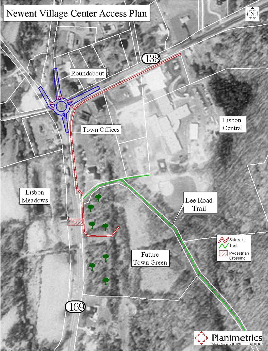
3 4-3

4 Address Municipal Facility Needs The concentration of community facilities in Newent is central to any considerations for the future of the area. Although the Town has acquired several important properties that will support a wide range of community objectives, no master plan has been developed to address these objectives. Additionally, future property acquisition in Newent should be considered by the Town to ensure adequate space for municipal services and recreational opportunities. This Plan recommends consideration of a municipal campus plan, as described below, to provide efficient public services consistent with the preservation of the Newent area s character and importance to the community. The municipal campus plan should incorporate the recommendations of the Lisbon Meadows Master Plan, and update those recommendations to reflect additional land acquisitions and the current and future needs for municipal facilities. Research for this Plan revealed a number of areas to be considered to ensure continued effective provision of municipal services: Town Offices and Meeting Space Community Center Facility Public Works Garage and Storage Resident State Trooper s Office Fire Station Storage and Training Capacity Recreational Facilities Future School Expansion All of Lisbon s municipal facilities are currently, and appropriately, located in Newent. However, this concentration has created potential and actual conflicts, particularly with respect to access and parking for the Lisbon Central School and the Public Works facility. Related conflicts involve bus parking at Lisbon Meadows Park. As the demand for municipal services grows, these and other constraints will increase. Each of these municipal facility needs and relevant planning recommendations are discussed below. Town Office Public Works Garage 4-4


5 Expand Town Offices The Lisbon Town offices are conveniently located in a functional and efficient building. However, these offices are limited in their capacity to meet the wide range of needs for meeting spaces, civic activities, document and supplies storage, and other typical municipal uses. Over the ten year Plan period, a space needs assessment should be conducted to determine the current and projected uses of municipal offices, the appropriate amount of space for such uses, and the space available to meet those needs. Standard space requirements for typical municipal functions may be obtained and evaluated in the context of Lisbon s specific needs. Clearly, the central location of the Town offices should be retained in any future facilities plan. The relocation of the fire station, discussed below, would open up opportunities for use of the existing facility for office or other municipal uses. Relocate Public Works and Public Safety Facilities The Town Public Works garage and Resident State Trooper s office are colocated in a single building behind Lisbon Central School. The central location of these facilities is important; however, space constraints and shared access with Lisbon Central School make clear the need to re-locate some or all of these important municipal functions. Similarly, the Lisbon Volunteer Fire Department facility is located adjacent to the school properties in an appropriate centralized location. The fire station is beginning to experience space shortages for the purposes of training programs and records management. Additionally, although adequate for the equipment and supplies currently in use, additional or larger new equipment as the community grows will require expansion or relocation of the fire station. Appropriate criteria for new facilities would include screening or buffering a public works facility from view and designing a fire station to be compatible with the character of its location. An example of design options that may be considered is shown below compared to the existing Newent Firehouse. Lisbon Volunteer Fire Department Firehouse Design Example 4-5
6 CONCEPTUAL NEWENT MUNICIPAL CAMPUS The Town has acquired several parcels of land in Newent, some of which include sufficient space and access to warrant consideration as possible sites for municipal facilities without compromising the recreational and open space goals set in the 2000 Master Plan for Lisbon Meadows. A conceptual municipal campus plan for Town properties in Newent is shown on the facing page, identifying nodes, or available sites, for current and future facilities. The table below lists existing and potential uses for each site. The suitability of the identified nodes for the suggested uses must be determined by further site specific investigations. Node Existing and Potential Uses Town Offices Community/ Senior Center A School Firehouse Public Works Playfields, Picnic, Tennis, Playscape Amphitheater, Gardens, Gazebo Bus Lot Recreation/ Open Space B Short term C Future School Uses D E F Future center G H Future School Long term : Current Use : Potential Use 4-6
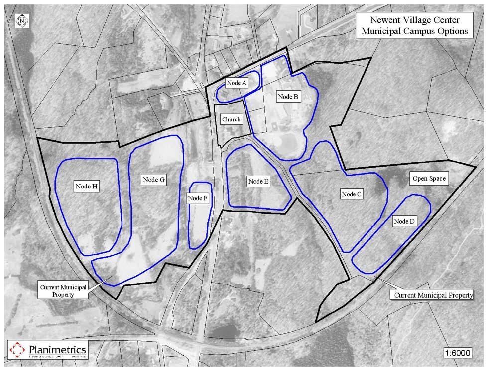
7 4-7


8 Establish a Community Center Facility Existing municipal facilities, other than Lisbon Central School, do not have sufficient capacity to allow for civic events and activities, recreational programs, and large meetings. School facilities are used, but scheduling can be difficult. Therefore, planning for additional municipal facilities should consider both the demand for and the best location for a community center to serve community needs. For example, a new firehouse facility could be designed to incorporate adequate space for public meeting and other civic activities. Plan for Future School Facilities Although the school age population projections prepared by the Connecticut Department of Education predict a declining school enrollment in Lisbon over the ten year Plan period, the Lisbon school administration believes that sufficient uncertainty exists to warrant planning now for future school facility needs. Certainly if the pace of residential development increases, as this Plan anticipates, demand for school and other services could increase beyond current projections. The current location of the Lisbon Central School, including the expansion now underway, is on property with additional development potential, particularly if the public works facility can be relocated. Additionally, that parcel abuts other Town-owned properties that have been previously identified as potential future school sites, shown on the conceptual campus map on page 4-7. Further evaluation would be necessary when a specific need is identified for school facilities. Support Implementation of Lisbon Meadows Master Plan Lisbon has committed significant resources to the development of recreational and open space opportunities at Lisbon Meadows, and the Town should continue this effort. The Master Plan should be updated as implementation proceeds to include other property acquisitions in Newent and to adjust or revise the Plan as may be determined necessary by the Town. 4-8

9 Consider a Special Design District Newent is located within a residential district, but the concentration of municipal and institutional uses there may warrant consideration of expanding the potential for limited commercial activity beyond that permitted in current residential zones. Properly designed and controlled, such uses can complement the visual and historic character of a neighborhood, while helping to ensure its preservation. Lisbon s goal of establishing a strong, community supported center may benefit from the increased activity that low intensity commercial uses would bring. The Town may consider regulations specific to a defined Newent area, including such typical special use standards as encouragement of multi-story, mixed use buildings with retail or pedestrianfriendly uses on the first floor and residential or office uses on upper floors, establishment of a build-to line or a maximum setback, rather than a minimum building setback from the street, to ensure compatible building sites, requirement of parking areas located to the rear of buildings and interconnected with a minimum of driveways that interrupt the pedestrian orientation, and use and dimensional standards that reduce any existing non-conformities and provide flexibility under a Special Permit review process. Appropriate uses within a Newent Center Design District may also be defined, including such activities as professional offices, antiques and crafts sales, galleries, and similar businesses. Although some of these may be currently allowed in residential districts, special regulations and a special permit process would ensure that they are undertaken in conformity with the overall goals for Newent. Evaluation of these options could be included in the special study recommended below, or may be undertaken separately when and if determined appropriate. An appropriate boundary for such a special design district would be established after development of goals for the district and detailed analysis of the properties, roads, access, and other considerations, all of which would be included in the Newent Village Center Study discussed below. Standard Setback Line Build-to Line 4-9

10 Newent Village Center Study The issues surrounding Newent municipal facilities, institutional uses, roads and pedestrian access, village character, and private properties are intertwined and cannot be considered independently. Therefore, the Plan recommends that Lisbon establish an ad hoc committee to define and conduct a Newent Village Center Study based on the recommendations and analyses in this Plan. Such a study would: determine municipal needs and identify the options and resources available to address them within the context of a consolidated Town center; identify ways to enhance and preserve the essence of Newent, including business village concepts, design standards, preservation of historic assets, and integration of open space, recreation, and greenway resources; and design and identify resources to enhance accessible and safe pedestrian circulation inside and outside the area with sidewalks, pedestrian walks, and trails. Technology now allows for the creation of an interactive three-dimensional visual design study model of defined areas. A study including such a model could help Lisbon residents and officials evaluate how specific improvements will look and how Newent will function once improvements are made. If established, the Newent Village Center Study Committee should investigate the potential of such technology, and other analytical techniques, to address: 1. Alternative scenarios for expansion of existing facilities or construction of new structures (including public works, public safety, community hall, and school facility expansion. 2. Roadway network and traffic circulation. 3. An appropriate sidewalk system in the core village area enhanced by connecting access to Lisbon Meadows and future greenways or trails. 4. Appropriate parking requirements in a mixed use village, and 5. Architectural guidelines appropriate for the village center. An example of this technological contribution on the facing page shows one conceptual municipal campus layout to illustrate how visual tools would help with the Newent Center planning process. 4-10
11 3-D Graphic Representation of Newent Center 4-11
12 Summary As much as by its landscape and peaceful setting, Lisbon is defined by its historic and valued village center at Newent. Building on this resource to establish a strong and contributing community focal point is a key goal for the Town in this Plan of Conservation and Development. Establish an Efficient Town Center Strategies Summary A. Pedestrian and Vehicle Access 1. Consider development of a sidewalk system connecting municipal properties and private institutions in Newent 2. Evaluate future Connecticut DOT plans for 169/138 intersection, propose alternatives 3. Seek funding for sidewalks and other Newent area improvements through Small Town Economic Assistance Program, Federal TEA grants, Quinebaug-Shetucket Rivers Valley Corridor programs, other sources B. Municipal Facilities 1. Conduct municipal space needs and facility availability assessment including offices, public works, public safety, schools, recreation, and community center. 2. Set goals for expanding town office capacity, relocating public works and public safety functions, establishing a community function center, and plan for future school facilities. 3. Initiate site assessment of municipal properties in Newent area for establishment of integrated municipal campus. 4. Monitor properties abutting existing municipal properties or located on State highways in Newent area for possible acquisition by the Town. C. Special Design District 1. Consider establishment of a special Newent Center Village Design District, subject to special permits for defined commercial uses consistent with overall goals for Newent 2. Develop standards for defined commercial and mixed uses, based on current home occupation standards and definitions, to address specific village design standards D. Newent Village Center Study 1. Establish ad hoc study committee to conduct a comprehensive study of Newent including municipal space needs assessment to determine necessary facilities for provision of municipal services means to enhance and preserve the essence of Newent, including special design district concepts, design standards, and preservation of historic assets designs and plans for accessible and safe pedestrian circulation inside and outside the area with sidewalks, pedestrian walks, and trails 4-12
CONCLUSION AND IMPLEMENTATION
 Lisbon s Vision CONCLUSION AND IMPLEMENTATION 7 Lisbon residents clearly appreciate the character, amenities, and opportunities that define our community. This Plan of Conservation and Development identifies
The West Vaughan Employment Area Secondary Plan Policies
 Part 2: The West Vaughan Employment Area Secondary Plan Policies 2.1 General Policies It is the policy of Council: 2.1.1. That the West Vaughan Employment Area (the WVEA), identified on Schedule 1, will
Public Meeting March 10 th 2011
 Public Meeting March 10 th 2011 Agenda 6:00-6:15 6:15-7:00 7:00-8:00 8:00-8:30 8:30-9:00 9:00 Welcome and Introductions Presentation» Project Overview» Recap Existing Conditions / Issues & Opportunities»
Metro. Activity Center Design Guidelines. Recommendations For Developing Focused, Mixed-Use Commercial/Residential Centers
 Metro Activity Center Design Guidelines Recommendations For Developing Focused, Mixed-Use Commercial/Residential Centers Metro Activity Centers What is a MAC? Legacy, the adopted guide for the future growth
City of Heath. Town Center Concept
 In the give-and-take of getting projects designed, financed, and approved, the famous refrain from the film Field of Dreams is heard often: if you build it, they will come. From the perspective of the
Bourne Downtown Site Planning
 Prepared for: The Town of Bourne, MA In Cooperation with: Bourne Financial Development Corporation Prepared by:, Inc. June 24, 2009 Table of Contents Introduction and Summary... 1 Site Existing Conditions...
A. Background Summary of Existing Challenges and Potential Possibilities. 1. Summary of Existing Assets and Potential Opportunities
 A. Background 1 A Main Street Master Plan Study was performed and completed in October of 2007. The study was initiated to review current land uses and development patterns along Main Street, from Parrish
Chapter 1 - General Design Guidelines CHAPTER 1 GENERAL DESIGN GUIDELINES
 CHAPTER 1 GENERAL DESIGN GUIDELINES 1.0 INTRODUCTION This Publication has been developed to provide current, uniform procedures and guidelines for the application and design of safe, convenient, efficient
3. VISION AND GOALS. Vision Statement. Goals, Objectives and Policies
 Vision Statement Queen Creek s interconnected network of parks, trails, open spaces and recreation opportunities provide safe and diverse activities and programs that sustain its unique, small town, equestrian
Planning Districts INTRODUCTION
 INTRODUCTION To facilitate detailed examination of development prospects for all areas of the community, Delano has been divided into 14 planning districts. The location of these planning districts is
Proposed Comprehensive Plan Strategies DRAFT for discussion June 28, 2017
 Proposed Comprehensive Plan Strategies DRAFT for discussion June 28, 2017 Land Use Rural Areas Refine the Farm and Forest area (FF) Update FF boundaries to account for existing lots less than five acres
URBAN DESIGN BRIEF. 2136&2148 Trafalgar Road. Town of Oakville
 URBAN DESIGN BRIEF 2136&2148 Trafalgar Road Town of Oakville Prepared By: METROPOLITAN CONSULTING INC For 2500674 Ontario Inc November 2016 TABLE OF CONTENTS Page No. 1.0 Introduction/Description of Subject
COMMUNITY DESIGN. GOAL: Create livable and attractive communities. Intent
 COMMUNITY DESIGN Intent An attractive, well-designed County will attract quality development, instill civic pride, improve the visual character of the community, and create a strong, positive image for
Town of Peru Comprehensive Plan Executive Summary
 Town of Peru Comprehensive Plan Executive Communities that plan grow by choice, not by chance. A plan makes growth thoughtful, understandable, and predictable. A plan shows that a community is managing
Section 9 NEIGHBORHOOD DESIGN
 Section 9 NEIGHBORHOOD DESIGN City of Lancaster Comprehensive Plan D u n k i n, S e f k o & A s s o c i a t e s, I n c. NEIGHBORHOOD DESIGN INTRODUCTION There are many ways in which a neighborhood can
Civic Center District
 Civic Center District The Civic Center district is the civic and social heart of Warrenville, containing such public buildings as the City Hall, Warrenville Public Library, Police Station, Park District
The transportation system in a community is an
 7 TRANSPORTATION The transportation system in a community is an important factor contributing to the quality of life of the residents. Without a sound transportation system to bring both goods and patrons
Hockessin Community Redevelopment Plan
 Hockessin Community Redevelopment Plan 3.1 Introduction The Community Redevelopment Plan for the Village of Hockessin is the result of the people s vision for a distinct village center that serves as the
Access Management: An Overview
 Figures 1-5 Below Evolution of development along a highway. In the early stages, land along the road is used for farming with little traffic generated. As time passes, the highway corridor becomes a de
Sewanee Village + Request for Builder/Developer Proposals
 Sewanee Village + Request for Builder/Developer Proposals Contact: Frank X. Gladu Special Assistant to the Vice Chancellor University of the South 735 University Ave Version 3 Sewanee TN 37383 Released:
North Oakville East Parks Facilities Distribution Plan. November, 2009
 North Oakville East November, 2009 POLICY CONTEXT 1) Purpose a) The purpose of this document is to be a guide for the location, configuration, design and development of the parks system for the North Oakville
NEIGHBORHOOD DESIGN ELEMENT
 NEIGHBORHOOD DESIGN ELEMENT INTRODUCTION The following recommendations constitute an urban design oriented "neighborhood analysis" of Plantation. It is an optional Comprehensive Plan Element. The five
DRAFT PLAN PRESENTATION
 DRAFT PLAN PRESENTATION 1.23.2018 AGENDA Process Project Schedule Results from Visioning Workshop Draft Plan Highlights Concept Plans Feedback Next Steps PROJECT SCHEDULE KICK-OFF WORKSHOP August 29 th
City of Farmington. Downtown Plan. Amendment to the 1998 Master Plan Adopted October 11, 2004
 City of Farmington Amendment to the 1998 Master Plan Adopted October 11, 2004 Introduction Planning Background 1 Scope and Components of the Plan Amendment 2 Concept Introduction 3 Plan Concepts 3 Conceptual
Town of Oakville Streetscape Strategy
 Town of Oakville Streetscape Strategy Endorsed by PDC on February 10, 2014 (PD-011-14) Town of Oakville Streetscape Strategy [endorsed by PDC February 10, 2014] 0 Town of Oakville Streetscape Strategy
Status Update (2006 vs. Now) Citizen s Advisory Committee February Plan for Prosperity
 Citizen s Advisory Committee February Plan for Prosperity") Status Update (2006 vs. Now) Citizen s Advisory Committee February 2018 Plan for Prosperity 2000 2017 2000 2017 Gardnerville Population 6,000 5,760 5746 5,500 5,000 5,067 5,550 5,165 5,394 5,412 5,250
Status Update (2006 vs. Now) Citizen s Advisory Committee February 2018 Plan for Prosperity 2000 2017 2000 2017 Gardnerville Population 6,000 5,760 5746 5,500 5,000 5,067 5,550 5,165 5,394 5,412 5,250
Regency Developments. Urban Design Brief. Holyrood DC2 Rezoning
 Regency Developments Urban Design Brief Holyrood DC2 Rezoning Stantec Consulting Ltd. 7-31-2017 1. Overview Regency Developments intends to rezone the lands located at 8510 and 8511 93 Avenue, within the
Goal 1: To Encourage the Orderly, Harmonious and Judicious Use of University Resources in the Development of University Land.
 2.0 Future Land Use Goal 1: To Encourage the Orderly, Harmonious and Judicious Use of University Resources in the Development of University Land. Objective 1.1: Make available future building sites that
ARTICLE 6: Special and Planned Development Districts
 ARTICLE 6: Special and Planned Development Districts 6-10 Traditional Neighborhood Development (TND) District 6-10.10 Purpose and Intent The Traditional Neighborhood Development (TND) District provides
Regional Context Statement
 Regional Context Statement REGIONAL CONTEXT STATEMENT 3. REGIONAL CONTEXT STATEMENT In 1995, the Provincial Government passed into law the Growth Strategies Act. The purpose of this provincial initiative
CHAPTER 7: Transportation, Mobility and Circulation
 AGLE AREA COMMUNITY Plan CHAPTER 7 CHAPTER 7: Transportation, Mobility and Circulation Transportation, Mobility and Circulation The purpose of the Transportation, Mobility and Circulation Chapter is to
4-Town Comprehensive Plan DRAFT 7/30/07
 4-Town Comprehensive Plan DRAFT 7/30/07 Acknowledgements ning Committee Town of Harrisburg Norman Roof Randy Nicol Town of Martinsburg Terry Thisse Paul Kelly Town of Montague Jan Bagdanowicz Wendy Perry
ANC 2A Presentation. November 9, 2006
 ANC 2A Presentation November 9, 2006 Introduction & Overview Applicants Boston Properties and KSI Services (project developers) The George Washington University (land owner) 2.66 acre site (former GW hospital
PROJECT BACKGROUND. Preliminary Design Scope and Tasks
 PROJECT BACKGROUND Preliminary Design Scope and Tasks The purpose of this Study is the development of preliminary designs for intersection improvements for Trunk Highway (TH) 36 at the intersections of
WATERFORD Plan of Preservation, Conservation and Development Supplement Part 1 - Policy Element
 WATERFORD 2012 Plan of Preservation, Conservation and Development 2015 Supplement Part 1 - Policy Element Effective June 11, 2015 2015 Plan Update GOAL To respond to the evolving land use needs and continually
Local Growth Planning in North Central Green Line Communities
 2018 April 30 Page 1 of 6 EXECUTIVE SUMMARY This report outlines a high-level scope for local growth planning for north central Green Line communities. The catalyst for this review is the significant investments
HE VISION. Building a Better Connected Place
 HE VISION Building a Better Connected Place WALK INTO THE FUTURE. Life in Cranberry, 2030 Here s what our residents told us they wanted to see in their community by 2030: The Cranberry of 2030 is a place
THAT the attached Terms of Reference for the Thornhill Centre Street Study be approved.
 COMMITTEE OF THE WHOLE AUGUST 18, 2003 THORNHILL CENTRE STREET STUDY PLANNING FILE: 15.92 Recommendation The Commissioner of Planning recommends: THAT the attached Terms of Reference for the Thornhill
Asbury Chapel Subdivision Sketch Plan
 Asbury Chapel Subdivision Sketch Plan PART 1: PROJECT SUMMARY Applicant: NVR Inc. Project Size: +/- 76.13 acres Parcel Numbers: 02101112,02116101,02116112, 02116113 Current Zoning: Transitional Residential
RECREATION, OPEN SPACE AND GREENWAYS ELEMENT GOALS, OBJECTIVES, AND POLICIES
 RECREATION, OPEN SPACE AND GREENWAYS ELEMENT GOALS, OBJECTIVES, AND POLICIES GOAL R-1: DEVELOP A RECREATION, OPEN SPACE AND GREENWAYS SYSTEM AS AN INTEGRAL COMPONENT OF AN OVERALL, COUNTY-WIDE ECONOMIC
Arlington, Virginia is a worldclass
 EXECUTIVE S U M M A RY Arlington maintains a rich variety of stable neighborhoods, quality schools and enlightened land use policies, and received the Environmental Protection Agency s highest award for
PARTF Scoring System for Grants
 PARTF Scoring System for Grants The members of the N.C. Parks and Recreation Authority use the PARTF scoring system as one of several tools to select grant recipients. Please provide all of the information
Seneca Meadows. Block 4 Locate office, technology, and medical development adjacent to I Screen views of garage structures from I-270.
 Seneca Meadows Seneca Meadows has an industrial park in its southern end and a mixed-use employment area planned for the north end. The district benefits from extensive I-270 visibility, stream valley
FLORIDA STATE UNIVERSITY MASTER PLAN 3 Urban Design
 FLORIDA STATE UNIVERSITY MASTER PLAN 3 Urban Design 2008 UPDATE URBAN DESIGN ELEMENT NOTE: Unless otherwise noted, the goals, objectives and policies contained in this element shall Guide development of
Executive Summary. NY 7 / NY 2 Corridor
 Executive Summary NY 7 / NY 2 Corridor Transportation and Land Use Study December 2005 Prepared for: Town of Colonie Capital District Transportation Committee Prepared by: Introduction: Land use decisions
Rio/29 Small Area Plan. Design Plan & Implementation Framework Open House - January 25, 2018
 Rio/29 Small Area Plan Design Plan & Implementation Framework Open House - January 25, 2018 MEETING PURPOSE PRESENTATION 1. Orient to the updated design plans 2. Introduce implementing options 3. Explain
Complete Neighbourhood Guidelines Review Tool
 Complete Neighbourhood Guidelines Review Tool Prepared By: City of Regina Planning Department October 2014 Page 1 of 14 Community Development Review Checklist for Secondary Plans and Concept Plans The
4.11 Town Centre Secondary Plan (Former City of Cumberland)
") 4.11 Town Centre Secondary Plan (Former City of Cumberland) 4.11.1 Town Centre Objectives 4.11.1.1 Introduction The reason for the preparation of this Secondary Plan for the Town Centre is as follows:
4.11 Town Centre Secondary Plan (Former City of Cumberland) 4.11.1 Town Centre Objectives 4.11.1.1 Introduction The reason for the preparation of this Secondary Plan for the Town Centre is as follows:
6 PORT SYDNEY SETTLEMENT AREA
 Section 6 Port Sydney Page 61 6 PORT SYDNEY SETTLEMENT AREA 6.1 Basis and Principles Village of Port Sydney Waterfront Community Existing Services 6.1.1 Port Sydney is an historic settlement that has developed
5.1 Site Plan Guidelines
 5. Community Core Guidelines Development of the Community Core will take place by plan of subdivision and site plan approval. It will occur in a phased manner that will reflect the timing of residential
Review of Opportunity Area C Draft Comprehensive Plan and Draft BOS Follow-On Motions. Special Working Group Meeting March 4, 2015
 Review of Opportunity Area C Draft Comprehensive Plan and Draft BOS Follow-On Motions Special Working Group Meeting March 4, 2015 The slides that follow identify where the draft Comprehensive Plan has
Neighborhood Districts
 NEIGHBORHOOD DISTRICTS SEVEN MAIN DISTRICTS Neighborhood Districts While the Development Plan provides a broad-scale overview of the neighborhood, this section focuses on uses and relationships at the
DRAFT DESIGN GUIDELINES
 IHZ Booklet #7 May 6, 2010 DRAFT DESIGN GUIDELINES CANTERBURY 7 Overview During the recent planning process for the Plan of Conservation and Development community character was identified as an important
IOWA HIGHWAY 57 / WEST 1 ST STREET STUDY PUBLIC INFORMATIONAL MEETING APRIL 22, 2014
 IOWA HIGHWAY 57 / WEST 1 ST STREET STUDY PUBLIC INFORMATIONAL MEETING APRIL 22, 2014 INTRODUCTION The City of Cedar Falls and the Iowa Department of Transportation are conducting a Public Informational
4.1.3 LAND USE CATEGORIES
 4.1.3 LAND USE CATEGORIES a. City Center District The City Center District incorporates the existing character and mix of uses in downtown Belmont to encourage redevelopment and new development in keeping
Developer s Program. The Station at East 54
 Developer s Program The Station at East 54 Existing Conditions The Station at East 54 is proposed for a 1.12 acre site at the northeast corner of Hamilton Road and Prestwick Road, tucked between the East
In surveys, Dallas residents say what they want to change most
 NEIGHBORHOODS ELEMENT In surveys, Dallas residents say what they want to change most in the city is its appearance they want it to look beautiful, with trees and pedestrian-friendly neighborhoods. The
Secrest Short Cut and Monroe Expressway Small Area Plan AUGUST 29, 2018
 Secrest Short Cut and Monroe Expressway Small Area Plan AUGUST 29, 2018 Background and Process Monroe Expressway will be open by the end of 2018 Union County and Indian Trail identified a need to revisit
Staff Report to the North Ogden City Planning Commission
 Staff Report to the North Ogden City Planning Commission SYNOPSIS / APPLICATION INFORMATION Application Request: Concept review on a legislative application to rezone land located at approximately 1750
St. Kevin s Area Planning Collaborative
 Table of Contents page 2 EXECUTIVE SUMMARY 3 MISSION STATEMENT 4 NEIGHBORHOOD CONTEXT 6 STREET CHARACTER 7 SITE PARAMETERS 9 COMMUNITY CHARRETTE - VISIONING GROUP TABLE 1 11 GROUP TABLE 2 12 GROUP TABLE
CITY OF PUYALLUP. Background. Development Services
 CITY OF PUYALLUP Development Services 333 South Meridian Puyallup WA 98371 To: City Council From: Katie Baker, AICP, Planning Division Re: South Hill Neighborhood Plan Adoption Date: (Meeting date: February
RECREATION AND OPEN SPACE ELEMENT GOALS, OBJECTIVES, AND POLICIES
 RECREATION AND OPEN SPACE ELEMENT GOALS, OBJECTIVES, AND POLICIES Goal 7 To provide park facilities, recreation programs, and open space resources that are safe, adequate, and accessible to all City residents,
UAA School of Engineering Parking Garage Master Plan Amendment. 1. Purpose
 UAA School of Engineering Parking Garage Master Plan Amendment 1. Purpose Since the UAA campus master plan was drafted in 2003, adopted in 2004, and amended in 2009 a number of significant changes regarding
Prosperity Hucks Area Plan. Transportation and Planning Committee May 11, 2015
 Prosperity Hucks Area Plan Transportation and Planning Committee May 11, 2015 Presentation Outline 1. Background and Location 2. Community Dialog Process 3. Activity Center Recommendations 4. Wedge Recommendations
VILLAGE & TOWN OF BERGEN: COMPREHENSIVE PLAN
 VILLAGE & TOWN OF BERGEN: COMPREHENSIVE PLAN CPC Public Hearing April 21, 2016 History 1996 Comprehensive Plan Comprehensive Plan Update Committee Consultant (LaBella Associates): December 2014 Residents
VILLAGE OF CLEMMONS PLANNING BOARD DRAFT STAFF REPORT
 VILLAGE OF CLEMMONS PLANNING BOARD DRAFT STAFF REPORT PETITION INFORMATION Docket # C-226 Staff Megan Ledbetter Petitioner(s) JBJH Properties, LLC Owner(s) JBJH Properties, LLC Subject Property 5892-49-1766
PRELIMINARY REPORT. HIGHWAY 18 CORRIDOR NEIGHBORHOOD PLAN VILLAGE OF DOUSMAN November, 2014
 PRELIMINARY REPORT HIGHWAY 18 CORRIDOR NEIGHBORHOOD PLAN VILLAGE OF DOUSMAN November, 2014 This preliminary report presents the initial recommendations for land use within the Highway 18 corridor along
MIXED-USE VILLAGE OVERLAY FLOATING DISTRICT
 MIXED-USE VILLAGE OVERLAY FLOATING DISTRICT Zoning regulations developed by committee to the Planning Board for the Town of DeWitt, NY Issue date: 13 July 2017 revised 3/12/2018, revised 4/26/2018, 5/9/2018
7Page 91 CLEMMONS COMMUNITY COMPASS 7 COMMUNITY CHARACTER
 7 Community Character The beauty of Clemmons won t necessarily be a reflection of our past, but our future. This quote from Comprehensive Plan Steering Committee member Wayne Dodson captures the essence
The Hartford Line Transit-Oriented Development (TOD) Action Plan. Maxwell L. Sokol, AICP WSP USA, Lead Planner New York, NY
 Action Plan. Maxwell L. Sokol, AICP WSP USA, Lead Planner New York, NY") The Hartford Line Transit-Oriented Development (TOD) Action Plan Maxwell L. Sokol, AICP WSP USA, Lead Planner New York, NY Key Presentation Take-Aways Deliberately build upon prior efforts at the local,
The Hartford Line Transit-Oriented Development (TOD) Action Plan Maxwell L. Sokol, AICP WSP USA, Lead Planner New York, NY Key Presentation Take-Aways Deliberately build upon prior efforts at the local,
Capital Projects in and near Odenton Town Center
 Capital Projects in and near Odenton Town Center Map ID Anne Arundel County Department of Public Works This project provides for the design, right of way acquisition, and construction of approximately
SECTION TWO: Urban Design Concepts
 SECTION TWO: Urban Design Concepts The Gardnerville Plan for Prosperity shapes economic opportunities presented by regional growth. The Urban Design Concepts provide policies and concepts for land use,
Brian Madigan, RLA, CPESC Director Land Planning & Design
 Brian Madigan, RLA, CPESC Director Land Planning & Design bmadigan@gymodpc.com Architecture, Engineering & Land Surveying, DPC 18969 US Route 11 Watertown, New York 13601 T: (315) 788-3900 F: (315) 788-0668
Master Plan for Preservation and Scenic Conservation (1995)
") 3.2 Master Plan for Preservation and Scenic Conservation (1995) The Master Plan for Preservation and Scenic Conservation was developed under the direction of the Guilford Preservation Alliance in the 1980s
3.2 Master Plan for Preservation and Scenic Conservation (1995) The Master Plan for Preservation and Scenic Conservation was developed under the direction of the Guilford Preservation Alliance in the 1980s
Route 1 Corridor Study
 Route 1 Corridor Study Westbrook, Connecticut A Vision for the Connecticut Shoreline Public Informational Meeting July 28, 2015 Lower Connecticut River Valley Council of Governments Fitzgerald & Halliday,
EXHIBIT A. Tax Increment Reinvestment Zone No. 1 (Town Center) First Amended Project Plan 1
 First Amended Project Plan 1") EXHIBIT A Tax Increment Reinvestment Zone No. 1 (Town Center) First Amended Project Plan 1 1 As amended by Resolution No. 2008-02-001(TR1R) of the Tax Increment Reinvestment Zone No.1, and approved to
EXHIBIT A Tax Increment Reinvestment Zone No. 1 (Town Center) First Amended Project Plan 1 1 As amended by Resolution No. 2008-02-001(TR1R) of the Tax Increment Reinvestment Zone No.1, and approved to
PINE CURVE REZONING. BACKGROUND Purchased as two parcels in 2001 and 2002
 BACKGROUND Purchased as two parcels in 2001 and 2002 WHAT THE PROJECT IS AND IS NOT A Rezoning establishes the land use standards for Annexed and Zoned Greater Downtown District Historic Center September
COUNTY COURT HOUSE REDEVELOPMENT AREA PLAN
 COUNTY COURT HOUSE REDEVELOPMENT AREA PLAN March 2005 CITY OF TRENTON DEPARTMENT OF HOUSING AND ECONOMIC DEVELOPMENT TABLE OF CONTENTS A. DESCRIPTION...3 1. BOUNDARIES OF PROJECT...3 2. REDEVELOPMENT PLAN
Comprehensive Plan ADOPTED APRIL 2014
 Comprehensive Plan ADOPTED APRIL 2014 8 8. Outstanding Recreational & Cultural Opportunities We are proud of our community s parks and recreation system. Our community will ensure that the legacy of our
implementation10 Village of Greendale Comprehensive Plan: Greendale, Wisconsin. Revisiting a Greenbelt Community
 implementation10 Village of Greendale Comprehensive Plan: 2010 - Village of Greendale Comprehensive Plan: 2010 - Implementation The recommendations of this Plan must be implemented by the Village of Greendale,
OPEN SPACE CHAPTER 7: OVERVIEW. Preserve open space to protect natural resources, enhance character and provide passive recreation opportunities
 CHAPTER 7: OPEN SPACE OVERVIEW Ridgefield has made tremendous progress permanently preserving areas of town as open space. Open space preservation can serve many important purposes, including: protect
11.4 Highway 400 North Employment Lands Secondary Plan APPROVED BY THE ONTARIO MUNICIPAL BOARD ON NOVEMBER 21, 2011
 11.4 Highway 400 North Employment Lands Secondary Plan APPROVED BY THE ONTARIO MUNICIPAL BOARD ON NOVEMBER 21, 2011 11.4.1 General 11.4.1.1. as approved by the Ontario Municipal Board on November 21, 2011,
Gold Line Bus Rapid Transit Transit Oriented Development (BRTOD) Helmo Station Area Plan
 Helmo Station Area Plan") Appendix F Gold Line Bus Rapid Transit Transit Oriented Development (BRTOD) Helmo Station Area Plan Introduction and Purpose of the Plan The Gold Line Bus Rapid Transit facility is an eleven-mile dedicated
Appendix F Gold Line Bus Rapid Transit Transit Oriented Development (BRTOD) Helmo Station Area Plan Introduction and Purpose of the Plan The Gold Line Bus Rapid Transit facility is an eleven-mile dedicated
E. RURAL COMMERCIAL/INDUSTRIAL PARK MODEL
 E. RURAL COMMERCIAL/INDUSTRIAL PARK MODEL 1. PURPOSE The purpose of the Rural Commerce/Industrial Park Model is to provide parameters within which a grouping of business buildings with parking, loading
Mill Conversion Overlay District Zoning Bylaw Amendment
 Mill Conversion Overlay District Zoning Bylaw Amendment To see if the Town will vote to amend the Zoning By-Law by adding a new Section 13, Mill Conversion Overlay District, and by amending Sections 2.1,
DRAFT. October Wheaton. Design Guidelines
 October 2011 DRAFT Wheaton Design Guidelines 2 Draft - Design Guidelines - Wheaton Sector Plan Contents 04 Section 1: Introduction 06 Section 2: Context 08 Section 3: Design Guidelines 09 Goal 1: Create
AGINCOURT SECONDARY PLAN
 1 AGINCOURT SECONDARY PLAN 1. AGINCOURT SECONDARY PLAN The following policies and principles apply to the area herein referred to as Agincourt, as outlined on Map 1-1. 1. GENERAL POLICIES 1.1 This Secondary
26/Old Dominion Task Force
 26/Old Dominion Task Force Meeting #9: March 21, 2019 Study Area Overview Staff Name, Department (DEPT ACRONYM) Preferred Scenarios Outline 1. Task Force Feedback from 3/7 2. Refined Concepts 3. Implementation
ELMVALE ACRES SHOPPING CENTRE MASTER PLAN
 ELMVALE ACRES SHOPPING CENTRE MASTER PLAN Contents 1.0 INTRODUCTION... 2 2.0 LOCATION... 2 3.0 EXISTING CONTEXT... 2 4.0 VISION & GUIDING PRINCIPLES... 2 5.0 LAND USE AND BUILT FORM... 4 5.1 St. Laurent
Welcome. Walk Around. Talk to Us. Write Down Your Comments
 Welcome This is an information meeting introducing the applications for proposed redevelopment of the Yorkdale Shopping Centre site at 3401 Dufferin Street and 1 Yorkdale Road over the next 20+ years,
The Floyds Fork Area Study A Framework for Growth
 The Floyds Fork Area Study A Framework for Growth 2 21 st Century Parks Master Plan: The Fork 3 Neighborhood Development Area Policy Recommendations 1. Create incentives to promote infill of existing development
City of Chickasaw Land Use Comprehensive Plan 2030 Chapter5-Draft(2)Public review_
Public review_") Land Use Land Use refers to the activity or development characteristics of a given parcel of land. The Land Use Plan presented in the following pages, represents the City of Chickasaw s official position
Land Use Land Use refers to the activity or development characteristics of a given parcel of land. The Land Use Plan presented in the following pages, represents the City of Chickasaw s official position
Section 4 BUILDING THE MASTER PLAN
 The Master Plan 33 Section 4 BUILDING THE MASTER PLAN Figure 4:1. A collaborative effort characterized the two design workshops sponsored by DISC to create hypothetical Master Plans for the Towers Property
TEMPLE MEDICAL & EDUCATION DISTRICT
 City of Temple, Texas TEMPLE MEDICAL & EDUCATION DISTRICT 1 Description. The City of Temple joined in partnership with key public and private entities to jointly promote education and medical activities
OPEN SPACE TYPES. SIZE 8 acres. SIZE 20 acres. SIZE 1 acre
 TYPICAL CHARACTERISTICS OPEN SPACE TYPES OPEN SPACE TYPES The neighborhood contains an extensive variety of open space types. Most of these spaces incorporate multiple uses and activities, so that each
DRAFT. 10% Common Open Space
 % OF CHARLOTTE IS CATEGORIZED AS A. LAND USES : Placeholder map displaying location of Place Type GOALS: Accommodate XX% of future growth. Provide a concentration of primarily commercial and civic activity
SECTION II SECTION II STATEMENT OF GOALS, OBJECTIVES, PRINCIPLES, ASSUMPTIONS, POLICIES AND STANDARDS
 STATEMENT OF GOALS, OBJECTIVES, PRINCIPLES, ASSUMPTIONS, POLICIES AND STANDARDS 1 2 STATEMENT OF GOALS, OBJECTIVES, PRINCIPLES, ASSUMPTIONS, POLICIES AND STANDARDS INTRODUCTION The New Jersey Municipal
CITY CLERK. Parkland Acquisition Strategic Directions Report (All Wards)
") CITY CLERK Clause embodied in Report No. 10 of the, as adopted by the Council of the City of Toronto at its meeting held on November 6, 7 and 8, 2001. 10 Parkland Acquisition Strategic Directions Report
CITY CLERK Clause embodied in Report No. 10 of the, as adopted by the Council of the City of Toronto at its meeting held on November 6, 7 and 8, 2001. 10 Parkland Acquisition Strategic Directions Report
Application Number: SD Project Name: Walton Farms Preliminary Subdivision (acting as Master Plan)
") STAFF REPORT Town of Clayton Planning Department 111 E. Second Street, Clayton, NC 27520 P.O. Box 879, Clayton, NC 27528 Phone: 919-553-5002 Fax: 919-553-1720 Planning Board May 22, 2017 Application Number:
STAFF REPORT Town of Clayton Planning Department 111 E. Second Street, Clayton, NC 27520 P.O. Box 879, Clayton, NC 27528 Phone: 919-553-5002 Fax: 919-553-1720 Planning Board May 22, 2017 Application Number:
MEMO 1. INTRODUCTION PURPOSE & PROCESS REQUEST
 MEMO Date: August 22, 2017 To: Board of Commissioners From: Jason Burdette, Planning Director Re: Davidson Commons East Hotel Stakeholder Feedback 1. INTRODUCTION PURPOSE & PROCESS This memorandum summarizes