MONTGOMERY COUNTY PLANNING DEPARTMENT THE MARYLAND-NATIONAL CAPITAL PARK AND PLANNING COMMISSION
|
|
|
- Arnold Warner
- 6 years ago
- Views:
Transcription
1 MONTGOMERY COUNTY PLANNING DEPARTMENT THE MARYLAND-NATIONAL CAPITAL PARK AND PLANNING COMMISSION MCPB Item No. Date: 12/11/2014 Ripley East Sketch Plan No SD Stephanie Dickel, Planner Coordinator, Area 1, Elza Hisel-McCoy, Supervisor, Area 1, Robert Kronenberg, Chief, Area 1, Completed: 12/1/2014 Description Construction of a mixed-use project with up to 349,847 square feet of residential development for up to 360 units and up to 17,300 square feet of non-residential uses; Current use: 2-story buildings; Located at the southwest corner of Georgia Avenue and Bonifant Street; 1.40 gross acres zoned CR 5.0: C 4.0, R 4.75, H 200T in the Ripley District of the Silver Spring CBD Sector Plan area and Ripley/South Silver Spring Overlay Zone; Applicant: Diamondback Investors, LLC; Filing date: September 15, Summary Staff recommends denial of the Sketch Plan No , Ripley East. The primary issues to be discussed within the report include master plan conformance and compatibility. The Application does not substantially comply with the Silver Spring Central Business District Sector Plan s height and step back requirements for compatibility.
2 TABLE OF CONTENTS SECTION 1: RECOMMENDATION 3 SECTION 2: SITE DESCRIPTION.3 Site Vicinity Site Analysis Zoning History SECTION 3: PROJECT DESCRIPTION..6 Proposal Uses and Density Buildings Open Space Environment Transportation Sector Plan Community Outreach SECTION 4: PROJECT ANALYSIS AND FINDINGS 20 2
3 SECTION 1: RECOMMENDATION AND CONDITIONS Staff recommends denial of Sketch Plan , Ripley East, for the construction of a mixed-use project with up to 349,847 square feet of residential development for up to 360 units and up to 17,300 square feet of nonresidential uses. As discussed in greater detail in this staff report, the proposed building is not consistent with the recommendation of the 2000 Silver Spring Central Business District Sector Plan, which allows for the increase in height above 90 feet, up to 143 feet, provided that the building is contained within a 2:1 slope. A Zoning Text Amendment was approved in 2007, which amended the height standards in the Ripley/South Silver Spring Overlay Zone to allow up to 200 feet in building height. The ZTA reinforced the Sector Plan as it acknowledged that the Silver Spring CBD Sector Plan recommends a maximum building height of 90 feet on Georgia Avenue with the ability to build 2 feet higher for every 1 foot back from Georgia Avenue. ZTA does not change that guidance. The Plan made the specific urban design recommendations on heights along Georgia Avenue in the Ripley District to provide compatibility across Georgia Avenue and to Fenton Village. The proposed Application does not achieve conformance with the urban design goals and guidelines and therefore does not implement the recommendations of the Silver Spring Central Business District Sector Plan. Planning Staff was prepared to discuss alternative designs with the Applicant that would comply with the Sector Plan, but the Applicant declined. SECTION 2: SITE DESCRIPTION Site Vicinity The subject site (Subject Property or Property) comprises several separate properties in Block 3: Lots 1, 2, and 3, and parts of Lots 4, 5, 7 and 8, located at the southwest corner of Georgia Avenue and Bonifant Street, approximately 1,000 feet from the Silver Spring Transit Center. The Subject Property is located on the eastern edge of the Ripley District of the Silver Spring Central Business District (CBD) Sector Plan (Sector Plan) and Ripley/South Silver Spring Overlay Zone. The Property is bound by the Pyramid Atlantic Arts Center to the south, a public alley to the west, Bonifant Street to the north, and Georgia Avenue to the east. The neighborhood surrounding the Subject Property is a mix of established low, mid and high-rise residential and non-residential buildings. To the north, across Bonifant Street, is a combination of high-rise office buildings, single-story retail, and the historic Silver Spring Post Office, currently used as a medical office. To the east, across Georgia Avenue, is predominantly low-rise retail along the western edge of the Fenton Village and a County surface parking lot that is part of Studio Plaza, an approved but unbuilt mixed-use high-rise project with residential units, street-level retail, and possible office and hotel uses. To the immediate south is the Pyramid Atlantic Arts Center, potentially relocating to the new Silver Spring Library site. Further to the south and southwest are single-story retail and two new high-rise residential buildings, the Solaire Silver Spring and Eleven55 Ripley. To the west is public parking, a mid-rise office building, and the Silver Spring Transit Center. The Purple Line will run along the south side of Bonifant Street between the Silver Spring Transit Center and the proposed Library Station. 3

4 Figure 1-Vicinity Map Site Analysis The 1.40-acre Property is improved with 2-story buildings, including the former Silver Spring National Bank and the Bethel World Outreach Church. It is zoned CR 5.0, C 4.0, R 4.75, H 200T and Ripley/South Silver Spring Overlay Zone. This development is subject to Chapter 22A, the Montgomery County Forest Conservation Law, but is exempt from the requirement to submit a Forest Conservation Plan under Section 22A-5(s)(1) because the proposed activity occurs on a tract of land less than 1.5 acres with no existing forest, or existing specimen or champion tree, and the afforestation requirements are not in excess of 10,000 square feet. (Attachment A) The site contains no forest, streams, wetlands, or environmental buffers. There are no known rare, threatened, or endangered species on site; there are no 100-year floodplains, stream buffers, or wetlands on site. There are no historic properties on site. 1 1 The Application includes development of the former Silver Spring National Bank located at 8252 Georgia Avenue. The bank site was presented to the Planning Board in 2003 for possibly historic designation, but the Planning Board declined to support the designation; thus, the site has no historic designation. 4
, which is essentially a high-rise residential zone with a maximum height of 200 feet.")
5 Wayne Ripley Street Georgia Avenue Subject Property Ripley District Figure 2-Aerial View Zoning History Prior to 2000, the Ripley District, a triangular area bordered by the railroad tracks on the west and Georgia Avenue on the east, was zoned Central Business District-Residential 2 (CBD-R2), which is essentially a high-rise residential zone with a maximum height of 200 feet. The entire Ripley District, including the Subject Property, was rezoned in 2000 with the Silver Spring CBD Sector Plan and Ripley/South Silver Spring Overlay Zone, to Central Business District 2 (CBD-2) to allow a greater mix of commercial and residential uses. This rezoning reduced the maximum height to 143 feet. Further, the purpose of the Ripley/South Silver Spring Overlay Zone was to address the special development issues in the Ripley/South Silver Spring area as identified in the Silver Spring Central Business District Sector Plan. Specifically, the zone was designed to: a) facilitate the implementation of an organized and cohesive development pattern that is appropriate for an urban environment; b) encourage attractive design and ensure compatibility with existing buildings and uses within and adjacent to the overlay zone; c) provide flexibility of development standards to encourage innovative design solutions; d) allow for the transfer of the public use space requirement to other properties within the Overlay District; and e) allow new uses. In 2007, the County Council approved Zoning Text Amendment (ZTA) No to amend the height standards in the Ripley/South Silver Spring Overlay Zone to allow up to 200 feet in building height for the CBD-2 portion of the Ripley District. The ZTA also acknowledged that the Silver Spring CBD Sector Plan recommended a maximum 5

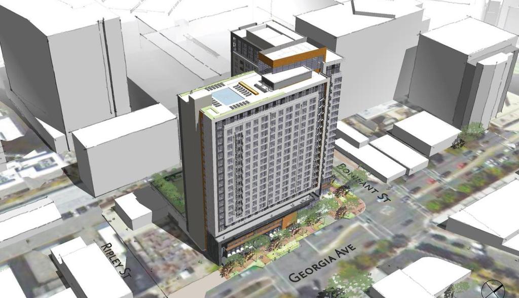
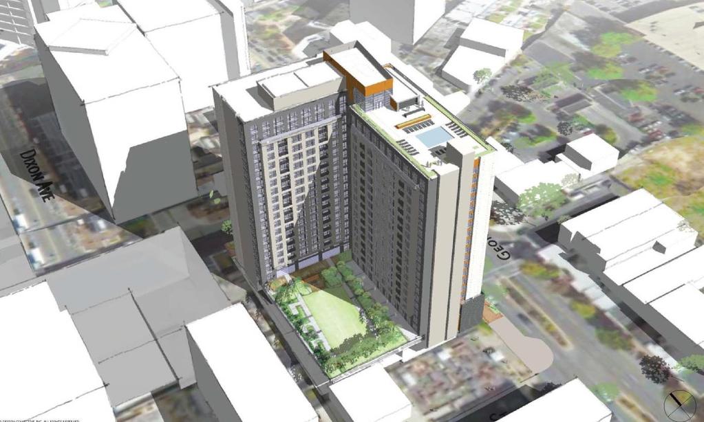
6 building height of 90 feet on Georgia Avenue with the ability to build 2 feet higher for every 1 foot back from Georgia Avenue and that ZTA did not change the Sector Plan guidance. As part of the Zoning Code rewrite, the Property was rezoned to CR-5.0, C-4.0, R-4.75, H-200T and the Ripley/South Silver Spring Overlay Zone through the Countywide District Map Amendment, approved by the Montgomery County Council on July 15, 2014, and effective on October 30, It is under the new CR zoning of the Property that this Application was processed. SECTION 3: PROJECT DESCRIPTION Proposal The Sketch Plan application (Application) proposes to redevelop the Property with a mixed-use building including up to 349,847 square feet of residential uses with up to 360 multi-family residential units, up to 17,300 square feet of non-residential uses, and up to 200 feet in height. Uses and Density Figure 3-Illustrative Perspective across Georgia Avenue The proposed redevelopment of the Property will be located on one new subdivision lot of record, consisting of 60,812 square feet of gross tract area. The Applicant proposes up to 349,847 square feet of residential uses with up to 360 multi-family residential units, including 15 percent MPDUs and up to 17,300 square feet of nonresidential uses, as well as underground parking, on-site amenities for the residents, and public open space and amenities. 6

7 The Property is zoned CR 5.0, C 4.0, R 4.75, H 200T. Under Section C.2 of the Zoning Ordinance, for CR zoned properties designated with a T, the residential density may be increased above the number following the R on the zoning map in proportion to any MPDU density bonus achieved under Chapter 25A of the County Code for providing more than 12.5% of the residential units as MPDUs. The total density may be increased above the number following the zoning classification on the zoning map by an amount equal to the residential bonus density achieved. Because the Application proposes 15% MPDUs, pursuant to the provisions of Chapter 25A of the County Code, the Application achieves a 22% residential density bonus. The resulting FAR is CR 6.04, C 0.28, R 5.75 with the height of 200 feet. The final unit count and non-residential square footage would be finalized at the time of Site Plan. Buildings The Application proposes to hold the street edges of Georgia Avenue and Bonifant Street to create an L-shaped building, which is comprised of two major masses set atop a base level that meet at the Georgia Avenue and Bonifant Street corner (Figures 4 and 5). Figure 4-Illustrative Elevation, Georgia Avenue and Bonifant Street corner A low two- to three-story volume, up to approximately 35 feet in height at the retail base, brings the building forward to the Property line along Georgia Avenue and Bonifant Street. The two primary towers, consisting of the remaining 18 floors, are setback six feet from the face of the lower volume. The Applicant believes this will create a more pedestrian scale and relate to the surrounding retail buildings. In addition, the Application proposes an offset roofline, with the Georgia Avenue frontage rising 19 stories and the Bonifant Street façade rising to 20 stories, and the central tower element rising above both primary masses. The two primary towers are connected with a central circulation tower, and are set back at the corner to create a public plaza. 7
8 Figure 5-Illustrative Elevations 8


9 Figure 6- View along Georgia Avenue looking north Figure 7- View at corner of Georgia Avenue and Bonifant Street 9


10 The majority of the interior space is comprised of residential dwelling units with select areas allocated for amenity space (Figures 8 and 9). The residential lobby is located between the retail spaces at the corner of Georgia Avenue and Bonifant Street. The lobby space contains the amenities for the tenants such as the concierge desk, mailroom, and cyber café. For cyclists and dog owners, a bike storage facility and dog washing room is proposed, to be located off the alley, and will connect to the service elevator. Additional amenities such as leasing, lounge, kitchen/dining, gaming, and fitness areas are proposed and located at the second level. Certain amenity spaces such as the dining area and lounge space will have an indoor/outdoor connection to the elevated courtyard. The rooftop level includes a raised pool deck with interior space associated with it such as restrooms and a small lounge. Figure 8- First Floor Figure 9- Typical Upper Level Floor Plan Open Space The Application proposes the Silver Spring streetscape along Georgia Avenue and Bonifant Street, including a public plaza at the corner of Georgia Avenue and Bonifant Street, a private courtyard atop the parking structure at the second level, located on the back side of the proposed building, along the alley, and a penthouse-level pool and deck area. The activating public plaza at the corner of Georgia Avenue and Bonifant Street allows for seating, gathering, and additional plantings. This space is created by a setback of the building at the corner and is proposed to be up to approximately 50 feet wide. It is envisioned that some café seating will occur at the face of the building as an extension of the retail uses there. In addition, public seating is proposed in the form of seatwalls, benches, or movable seats. Other amenities in the plaza may include special lighting, artworks, and planting beds with shrubs, groundcovers, and perennials. 10
11 The Application proposes to set the building back from Georgia Avenue and Bonifant Street with significant sidewalk widths ranging from approximately feet and approximately feet along Bonifant Street, with final widths determined at the time of Preliminary Plan and Site Plan. The Applicant proposes a setback along Georgia Avenue to provide a wider sidewalk for a more pleasant pedestrian experience with opportunities for outdoor seating for retail or restaurant uses. The setback of the building from the Bonifant Street right-ofway is also in anticipation of the Purple Line that will run down Bonifant Street just several feet from the curb line. The Applicant will provide a wider sidewalk along this frontage in order to provide greater separation between the building and the Purple Line operations, promoting further pedestrian comfort and allowing room for possible outdoor retail/restaurant seating options. The private courtyard atop the retail and service/loading areas (at the second level of the building) features a rectangular lawn panel with raised planters filled with plantings. Entry to the courtyard is from the clubroom. Residents will step out onto an expansive deck including a variety of seating options and an outdoor kitchen area. At the rooftop level, a small pool and deck area are proposed. The Application includes 7.2% of the net lot area of the Property, or 2,569 square feet, as public open space, which is greater than the CR zone requirement of 5% public open space, for the property. The open space requirement is based on the lot area and number of frontages, and this Application has three frontages and the net lot area is of the site is acres. Environment Forest Conservation This Application is subject to the Chapter 22A, Montgomery County Forest Conservation Law, but is exempt from the requirement to submit a Forest Conservation Plan under Section 22A-5(s)(1) because the proposed activity occurs on a tract of land less than 1.5 acres with no existing forest, or existing specimen or champion tree, and the afforestation requirements are not in excess of 10,000 square feet. Noise The proposed Purple Line and nearby transit station would likely generate some level of noise impacts to the Subject Property. A noise analysis would be required at the time of Preliminary Plan to determine whether or not mitigation techniques are needed. Stormwater Management The Applicant submitted a Stormwater Management Concept Plan to Department of Permitting Services (DPS) on August 8, Approval of the Stormwater Management Concept Plan is not required at the time of Sketch Plan and further details on the concept and approval would be required at the time of Preliminary Plan. 11

12 Transportation Access and Circulation Vehicular access to the Property is provided directly from an existing one-way (southbound) public alley located west of the site off Bonifant Street, approximately 200-feet west of Georgia Avenue. Following construction of the Purple Line light rail project, which will operate on Bonifant Street along the site frontage, Bonifant Street will operate as a single-lane one-way (westbound) street between Georgia Avenue and Ramsey Avenue. Resident vehicular parking is proposed to be contained within a structured subgrade garage beneath the proposed building. (Figure 10) Bonifant Street is currently improved as a three-lane Business District roadway within a 70 foot-wide public right-of-way and is configured to accommodate a single lane of westbound traffic and two lanes of eastbound traffic. At its intersection with Georgia Avenue, eastbound traffic must turn either left or right onto Georgia Avenue; no through-traffic is permitted across Georgia Avenue at this intersection. Georgia Avenue (MD 97) is currently improved as a six-lane Major Highway within a variable-width right-of-way that will remain in its current configuration and will be dedicated to its ultimate right-of-way of 140 feet. This right-of-way is consistent with the minimum right-of-way requirements described in both the 2000 Silver Spring CBD Sector Plan and the 2013 Countywide Transit Corridors Functional Master Plan. Vehicular Circulation Bicycle Circulation Pedestrian Circulation Future Purple Line Figure 10-Vehicular Circulation 12

13 Pedestrian and bicycle access to the Property will be provided along the property s Georgia Avenue and Bonifant Street frontages (Figure 11). As a result of the proposed right-of-way dedication, pedestrian accommodation on the Bonifant Street frontage will be at least 24 feet from the building face to roadway, significantly greater than the existing 5 foot-wide sidewalk. Additionally, the Application will provide a designated bicycle garage entrance for building residents via the public alley along the rear of the building. No specific master planned bikeways are recommended for either Bonifant Street or Georgia Avenue, though the 2000 Silver Spring CBD Sector Plan identifies Bonifant Street as a mixed street that could accommodate biyclists within the vehicular travelway. However, the Sector Plan did not anticipate the Purple Line on Bonifant Street. Vehicular Circulation Bicycle Circulation Pedestrian Circulation Future Purple Line Figure 11-Pedestrian Circulation Transit Connectivity The immediate area is well served by transit that includes the Red Line Silver Spring Metrorail Station, Metrobus, RideOn, and the Silver Spring VanGo Circulator. Future transit in the area includes a proposed Purple Line station at the existing Silver Spring Metrorail Redline station, to the west, and a Purple Line station at the new Silver Spring Library, to the east. Specific transit routes near the Site include: 1. RideOn Bus Routes 1, 2, 3, 4, 5, 8, 9, 11, 12, 13, 14, and WMATA Metrobus Routes J5, Q1, Q2, Q4, S2, S4, Y5, Y7, Y8, Y9, Z2, Z6, Z8, Z9, Z11, Z13 13
14 Sector-Planned Transportation Demand Management As a commercial development within the Silver Spring Transportation Management District (TMD), the Applicant is required to enter into a Traffic Mitigation Agreement to participate in the Silver Spring TMD. Adequate Public Facilities Adequate Public Facilities ( APF ) review will be conducted at the time of Preliminary Plan. Although the Application is not eligible for formal APF transportation review at Sketch Plan, Staff is including the following preliminary analysis of traffic impacts. The proposed development will generate 117 morning peak-hour trips and 143 evening peak-hour trips (Table 1). As a result of the proposed transportation impact, a full traffic study will be submitted with the subsequent Preliminary Plan application. Table 1: Proposed Ripley East Application Trip Generation Morning Peak Hour Evening Peak Hour In Out Total In Out Total Proposed General Retail 360 High Rise Apartments Total Source: Kimley Horn. Traffic Statement, dated October 7, Transportation Policy Area Review (TPAR) Since the proposed development is within the Silver Spring CBD Policy Area, the Application is exempt from both the roadway and transit tests set forth in the Subdivision Staging Policy. As a result, the proposed development is not required to pay the transportation impact tax to satisfy the TPAR requirement. 14

15 Sector Plan Land Use and Zoning The Property is located within the Ripley District area as identified in the Silver Spring CBD Sector Plan approved and adopted February The Sector Plan contains specific recommendations for the Ripley District. Consistent with page 45 of the Plan, the Ripley District is envisioned as a revitalized, mixed-use district with its primary focal point a high-density commercial development. It will link Georgia Avenue and East West Highway with bike trails and pedestrian routes, organized around open space. (Figure 12) Figure 12-Ripley District Concept Plan The objective for the Ripley District is to Encourage mixed-use development near the Transit Center by facilitating market feasible development and upgrading the physical environment. Recommendations for implementing this objective include (page 47): New zoning should facilitate a new inter-connected street system, allow an expanded range of marketresponsive uses near Metro, and address obstacles to development that include small parcels not suitable for a combination of building floor area and required open space, and the reduction of available building area due to dedication of the Metropolitan Branch Trail. The zoning should also facilitate improvements to the character of Georgia Avenue. 15

16 Retain the CBD-2 Zone on parcels currently zoned CBD-2. Existing zoning supports the Plan's vision and goal, as stated above, by allowing a variety of uses and providing enough density to encourage redevelopment of the Ripley District near the Transit Center. Rezone all CBD-R2 properties in the Ripley District to CBD-2. CBD-2 zoning will encourage redevelopment near the Transit Center by allowing more commercial density in response to the current market. CBD-2 also provides the flexibility for both commercial or residential high-rises, or mixed use projects, whereas the CBD-R2 zone was intended primarily to stimulate high-rise residential development. Projects approved under the CBD-R2 zone in the Ripley and South Silver Spring areas have not been built because high-rise housing has not been economically viable in Silver Spring in recent years. The rents which can be supported by the Silver Spring market cannot cover the development costs associated with high-rise housing. Apply the Ripley/South Silver Spring Overlay Zone to portions of the Ripley District. This overlay zone will encourage redevelopment in the Ripley District by providing more flexibility in the development standards and the range of permitted uses, while ensuring that new development is compatible with nearby uses. Figure Ripley District Existing Zoning Figure Ripley District Proposed Zoning Subject Property Subject Property 16
17 The intent of the overlay zone, as stated above is to encourage redevelopment in the Ripley District by providing more flexibility in the development standards and the range of permitted uses, while at the same time, the overlay zone would be structured to ensure that new development is compatible with nearby uses and that it incorporates critical design elements, such as streetscaping and useful public open spaces. (Page 58) The recommendations section of the Sector Plan does not include specific language for the Subject Property. Subject Property Figure 15-Ripley/South Silver Spring Overlay Zone Urban Design The Sector Plan provides the following urban design goals and guidelines for future development in the Ripley District (pages 83-85). These recommendations apply to the Subject Property. Prepare drawings that illustrate development options for the Ripley District. 17
18 Make connections to the proposed Transit Center, the Capital Crescent/Metropolitan Branch Trail, and other CBD facilities and neighborhoods Incorporate one or more recreational facilities sized and programmed to meet community interests, and that make use of their urban location Create open spaces designed to form a new image for this neighborhood, and contribute to an improved visual quality along Georgia Avenue. Building heights along Georgia Avenue should contribute to an attractive and coherent street. At the building line, limit height to 90 feet, consistent with height limits on the east side of Georgia Avenue. [see the following Figure 16 - Figure 4, page 84 of the Sector Plan] The building may step back and its height may be increased up to 143 feet, provided that the building is contained within a 2:1 slope. These explicit recommendations above, of which the County Council reinforced in 2007 with the ZTA approval, compelled the Planning Department Staff to recommend denial of the proposed Sketch Plan application, as discussed further in the report in Section 4, Project Analysis and Findings. Figure 16-Georgia Avenue Street Section Housing The housing objective of the of the Plan is to develop new residential projects to provide housing and encourage maintenance of existing housing, creating Silver Spring as an even more desirable residential market. The recommendations include: provide housing choice and market-feasible development options, including apartments and townhouses; rezone CBD properties to encourage residential development; and convert selected public sector surface parking lots to housing. 18

19 On page 113 of the Sector Plan (as shown in Figure 17), the Subject Property is called out as a potential housing site. Subject Property Figure 17-Residential Downtown Historic Resources The Application includes development of the former Silver Spring National Bank located at 8252 Georgia Avenue. The bank site was presented to the Planning Board in 2003 for possibly historic designation, but the Planning Board declined to support the designation; thus, the site has no historic designation. Staff would also like to clarify that on page 139 of the Sector Plan, on Map 42, the Silver Spring Post Office is incorrectly located on the Subject Property. The correct location is a block north of the Subject Property. Community Outreach The Applicant has met all signage, noticing, and submission meeting requirements. On July 17, 2014, the Applicant held a pre-submittal public meeting at the Silver Spring Civic Building. Staff has not received any correspondence on this matter. 19
20 SECTION 4: PROJECT ANALYSIS AND FINDINGS The purpose of a Sketch Plan is to identify general land uses, development intensity, and public benefits for the optional method of development in the CR, CRT, EOF or LSC Zones. The Sketch Plan is intended to be conceptual in nature with an emphasis on building densities, massing, heights and anticipated uses, the locations of open and public use spaces, the general circulation patterns for all modes of transportation, an estimated range of peak hour trips and relationships between existing or proposed adjacent buildings and rights-of-way. Details of the proposed development are determined during Preliminary and Site Plan review. Section E of the Zoning Ordinance states: To approve a sketch plan the Planning Board must find that the following elements are appropriate in concept and appropriate for further detailed review at site plan. The sketch plan must: 1. meet the objectives, general requirements, and standards of this Chapter; The Sketch Plan meets the development standards of Section , as shown in the Data Table below: Project Data Table for the CR5.0 C4.0 R4.75 H200 T Zone Development Standard Permitted/Required Proposed Section Gross Tract Area (sf) n/a 60,812 Maximum Density (CR) Non-residential (C) Residential (R) FAR (304,060 sf) 4.0 FAR (243,248 sf) 4.75 FAR (288,857 sf) Up to 6.04 FAR (367,147 sf) 3 Up to 0.28 FAR (17,300 sf) Up to 5.75 FAR (349,847 sf) Building Height (feet) Minimum Public Open Space (%) 5% (1,781 sf) 7.2% (2,569 sf) Parking (spaces) Multi-family Restaurant Retail/service establishment Minimum 1 space/unit; Maximum 1 space/studio, 1.25 space/one bedroom, 1.5/two bedroom Minimum 4 space/1,000 sf of patron use; Maximum 12 space/1,000 sf of patron use Minimum 3.5 space/1,000 sf GLA; Maximum 6 space/1,000 sf of GLA TBD at Site Plan TBD at Site Plan TBD at Site Plan 2 As noted previously, pursuant to Section C.2 of the Zoning Ordinance, for CR zoned properties designated with a T, residential density may be increased above the number following the R on the zoning map in proportion to any MPDU density bonus achieved under Chapter 25A of the County Code for providing more than 12.5% of the residential units as MPDUs, and total density may be increased above the number following the zoning classification on the zoning map by an amount equal to the residential bonus density achieved. 3 The Application utilizes the optional method of development to develop the Property with up to the maximum density (6.04 FAR, with up to 5.75 FAR in residential uses and up to 0.28 FAR in non-residential uses (retail and/or restaurant) and the maximum height (200 feet) permitted for the Property under the CR Zone and Ripley District Overlay Zone (including as the result of provision of 15% MPDUs and the accompanying 22% residential density bonus). Final proposed density and final building heights will be determined at the time of Site Plan. 4 Although, the zone allows for 200 in height, the Sector Plan specifically recommended limiting the height to 90 feet at the building line, consistent with height limits on the east side of Georgia Avenue and that the building may step back and its height may be increased up to 143 feet, provided that the building is contained within a 2:1 slope. 20
21 The Application will provide the minimum required number of bicycle parking spaces for residents, visitors, and commuter shower/change facilities within each building at the time of Site Plan. The number of parking spaces will be determined at Site Plan based on the number of residential dwelling units. a) Implement the recommendations of applicable master plans. Land Use and Zoning The Ripley District is envisioned as a revitalized, mixed-use district with its primary focal point a high-density commercial development. The Sketch Plan proposes a mixed-use development with both high-rise residential uses as well as ground-floor retail or other non-residential uses. The Application proposes up to 360 multi-family residential units (with final unit count and unit mix to be determined at Site Plan) with 15% on-site MPDUs and up to 17,300 square feet of non-residential uses. Although the Plan called for a new inter-connected street system, it did not propose any new streets to be constructed though the Property. The Plan also calls for facilitating improvements to the character of Georgia Avenue and the Application does propose to improve upon the existing street frontages of Georgia Avenue and Bonifant Street, providing an enhanced pedestrian environment through setbacks for a wider sidewalk and streetscaping features. All loading and vehicular access will be from the alley on the west side of the Property. The Plan also called for addressing obstacles to development that include small parcels not suitable for a combination of building floor area and required open space, and the reduction of available building area due to dedication of the Metropolitan Branch Trail. The Applicant has assembled the Property by acquiring a number of small parcels in the Ripley District. While the Application is not located adjacent to the Metropolitan Branch Trail, the Applicant anticipates the significant number of residents who will take advantage of the nearby bicycle facilities and trails, and therefore proposes a bicycle-only access into the Property from the alley on the west side of the building. Although the 2000 Plan calls to retain the CBD-2 Zone on parcels currently zoned CBD-2 and rezone all CBD-R2 properties in the Ripley District to CBD-2, the Property was rezoned through the Zoning Ordinance rewrite to CR-5.0, C-4.0, R-4.75, H-200T and Ripley Overlay Zone, effective October 31, The intent of the CBD-2 zoning was to encourage redevelopment near the Transit Center by allowing more commercial density in response to the current market (in 2000), but also provide the flexibility for both commercial or residential high-rises, or mixed use projects. The Application proposes a mixed-use, high-rise residential development with groundfloor non-residential uses under the optional method of development, which satisfies the intent of the CBD-2 Zone. The Application conforms to the Sector Plan recommendations for Land Use and Zoning. Urban Design The Sector Plan also provides urban design goals and guidelines for future development in the Ripley District: Make connections to the proposed Transit Center, the Capital Crescent Metropolitan Branch Trail, and other CBD facilities and neighborhoods. 21
22 The Property is located approximately 1,000 feet east of the Silver Spring Transit Center, and within two blocks of the Metropolitan Branch Trail. The Application facilitates pedestrian access to and from these and other CBD facilities with its proposed wider sidewalks along the Georgia Avenue and Bonifant Street frontages, to be improved to the Silver Spring streetscape standard. In addition, the Application includes access for bicyclists either residing at or visiting the Property, with a designated bicycle access point on the west side of the Property off the public alley. With easy access to two Purple Line stations (the SSTC and the proposed Library Station), residents and visitors to the site will have improved connection to these CBD facilities and neighborhoods that surround them. Incorporate one or more recreational facilities sized and programmed to meet community interests, and that make use of their urban location. The Application s public plaza at the corner of Georgia Avenue and Bonifant Street provides the opportunity for a sitting and gathering space. In addition, the Application proposes recreational facilities and amenities for its residents such as a rooftop pool and fitness center. Create open spaces designed to form a new image for this neighborhood, and contribute to an improved visual quality along Georgia Avenue. The Applicant proposes to improve the Georgia Avenue streetscape through a significant setback of the building from the curb and with the Silver Spring standard streetscape improvement along the length of the Property. Outdoor seating options for the ground-floor retail or restaurant uses could activate this frontage. In addition, the public plaza at the corner of Georgia Avenue and Bonifant Street would improve the visual quality of Georgia Avenue as vehicles and pedestrians pass by. Building heights along Georgia Avenue should contribute to an attractive and coherent street. At the building line, limit height to 90 feet, consistent with height limits on the east side of Georgia Avenue. The building may step back and its height may be increased up to 143 feet, provided that the building is contained within a 2:1 slope. The Application does not substantially conform to the above design guidelines for new development along Georgia Avenue in the Ripley District. The proposed building does not hold the height limit at the building line to 90 feet. Instead, the Application proposes to hold the street edges of Georgia Avenue and Bonifant Street with an L- shaped building up to 200 feet in height (Bonifant Street façade rising to 20 stories, the and the Georgia Avenue frontage at 19 stories). The Sector Plan allows for additional height, as long as a step back is provided starting at 90 feet and is contained within a 2:1 slope. The proposed building includes a 35 foot base along the Georgia Avenue frontage above which rises the remaining 165 feet of the building, set only six feet back from the base. The Application does not provide a step back starting at 90 feet within a 2:1 slope. The Applicant s proposal with a 200 foot 22
23 building height, exacerbated by the approximately 205 feet of the building fronting directly on Georgia Avenue, results in a building with an imposing presence along Georgia Avenue and a lack of compatibility with the existing development across the street. Zoning Text Amendment No and the CR Zone for this Property allow up to 200 feet in building height for the Subject Property. However, the ZTA reinforced the Sector Plan as it acknowledged, the Silver Spring CBD Sector Plan recommends a maximum building height of 90 feet on Georgia Avenue with the ability to build 2 feet higher for every 1 foot back from Georgia Avenue. ZTA does not change that guidance. The specific recommendations on heights along Georgia Avenue at the edge of the Ripley District were included to ensure compatibility between development along both sides of Georgia Avenue, which forms the edge between the Ripley District on the west and Fenton Village on the east. The Sector Plan had a specific idea of what constitutes compatible development, and the Application does not achieve that compatibility. The Application does not substantially conform to the urban design goals and guidelines for building height along Georgia Avenue and therefore does not fully implement the recommendations of the Plan. Housing The housing objective of the Plan is to develop new residential projects to provide housing and encourage maintenance of existing housing, creating Silver Spring as an even more desirable residential market. The Plan identified the Subject Property as a housing site. The Application proposes a new mixed-use project with up to 360 multifamily residential units with 15% on-site MPDUs, offering housing opportunities proximate to the numerous transit options of downtown Silver Spring. The Application meets the Sector Plan housing objective. Historic Resources The Plan did not recommend designation of the Subject Property as historic. However, the Application includes development of the former Silver Spring National Bank located at 8252 Georgia Avenue. The bank site was presented to the Planning Board in 2003 for possibly historic designation, but the Planning Board declined to support the designation, thus the site has no historic designation. b) Target opportunities for redevelopment of single-use commercial areas and surface parking lots with a mix of uses. The Property is currently comprised of vacant lots and existing aging buildings. The Application proposing to redevelop the lots and existing single-use buildings on the site with a higherdensity mixed-use development with underground parking to maximize residential development within a quarter mile from the Silver Spring Metro and the planned Purple Line. The Application includes ground-floor non-residential uses, upper level residential units, public open space and residential amenity space. The Application meets the objective of this finding. c) Encourage development that integrates a combination of housing types, mobility options, commercial services, and public facilities and amenities, where parking is prohibited between the building and the street. 23
24 The Application encourages such development by proposing market-rate residential units in a variety of unit types (studios, one-, and two-bedrooms) as well as 15% MPDUs, offering housing opportunities for a range of incomes proximate to the numerous transit options of downtown Silver Spring. The proposed non-residential uses (retail and/or restaurant) on the ground floor provide commercial services for the residents and surrounding neighborhood. The Application facilitates all modes of transit pedestrian, bicycle, and vehicular, proximate to the Purple Line and the SSTC. It proposes wide sidewalks along Georgia Avenue and Bonifant Street for pedestrian passage and comfort as well as a large public plaza at the corner of Georgia Avenue and Bonifant Street. The Application proposes a separate access point for bicycles and will provide vehicular parking and loading access to meet market demands. The Application does not propose any parking between the building and the street frontages. d) Allows a flexible mix of uses, densities, and building heights appropriate to various settings to ensure compatible relationships with adjoining neighborhoods. The Application proposes a mixed-use project with multifamily residential units and commercial/retail uses with a building height of 200 feet, as allowed in the CR-5.0, C-4.0, R-4.75, H-200T zone. Adjacent building heights and uses in the Ripley District, west of the Property, include the recently completed Eleven 55 Ripley and Solaire Silver Spring to the west and southwest, with heights up to 200 feet. Directly on the east side of Georgia Avenue, are existing one-two story retail/commercial buildings and two projects that have just begun or are soon to begin construction: Bonifant at Silver Spring and Studio Plaza, both with a height limit of 110 feet. The Application s proposed building height does not provide an appropriate transition to the existing and proposed development on the east side of Georgia Avenue and with Fenton Village as recommended in the urban design goals and guidelines in the Sector Plan. As discussed in Finding 1a above, the Plan made specific urban design recommendations for new development along Georgia Avenue in the Ripley District to ensure compatibility with adjoining neighborhoods and to provide a coherent street. Specifically the Plan states, At the building line, limit height to 90 feet, consistent with height limits on the east side of Georgia Avenue. The building may step back and its height may be increased up to 143 feet, provided that the building is contained within a 2:1 slope. This urban design goal assessed compatibility in building heights across Georgia Avenue based on the surrounding neighborhood in particular, the recommendations made for Fenton Village. The recommendations for Fenton Village limit building height for new construction fronting along the east side of Georgia Avenue to 90 feet, and 60 feet for remaining properties, interior to the block, to the west of Fenton Street. (Page 91) The Application proposes a building height of 200 feet without the step back at 90 feet and does not provide a compatible relationship with the adjoining neighborhood on the east side of Georgia Avenue and does not follow the recommendations set forth in the Sector Plan. Furthermore, while Zoning Text Amendment No allowed building heights up to 200 feet in the CBD-2 portion of the Ripley/South Silver Spring Overlay Zone, it acknowledged that the Sector Plan recommends a maximum building height of 90 feet on the west side of Georgia Avenue, with the ability to build 2 feet higher for every 1 foot back from Georgia Avenue. The County Council specifically clarified that the ZTA did not change that guideline. The Application s proposed 200 building height is not appropriate at this location, does not ensure compatible relationships with adjoining neighborhoods, and therefore does not meet the finding. 24
25 e) Integrate an appropriate balance of employment and housing opportunities. The Application will help to meet the need for additional housing options in the Ripley District. The mixed-use development will provide more residents to patronize local businesses, and strengthen the Ripley District as a revitalized, mixed-use district. Additionally, providing more housing stock in the CBD provides greater opportunities for employment, a fundamental ingredient for the smart growth promoted by the CBD zones. The Application proposed a variety of housing options through provision of both market-rate units and MPDUs in an array of unit sizes. In addition, the Application provides non-residential uses such as retail and/or restaurant. f) Standardize optional method development by establishing minimum requirements for the provision of public benefits that will support and accommodate density above the standard method limit. The Application will provide the required public benefits from a minimum of four categories to achieve the desired incentive density above the standard method limit. 2. substantially conform with the recommendations of the applicable master plan; As discussed earlier, the Sector Plan provided urban design goals and guidelines for development along the edge in the Ripley District, specifically stating: Building heights along Georgia Avenue should contribute to an attractive and coherent street. At the building line, limit height to 90 feet, consistent with height limits on the east side of Georgia Avenue. The building may step back and its height may be increased up to 143 feet, provided that the building is contained within a 2:1 slope. Although ZTA No , allows up to 200 feet in building height, it did not change the Plan s guidance. The Application, as proposed, does not provide the recommended step back at 90 feet with a 2:1 slope and so it does not meet the recommendations of the Sector Plan. Instead, the Application proposes to hold the street edges of Georgia Avenue and Bonifant Street with an L-shaped building, comprised of two major masses above a 35 foot street retail base that meet at the Georgia Avenue and Bonifant Street corner. The two primary masses rise up to approximately 200 feet (the Georgia Avenue frontage at 19 stories and the Bonifant Street façade rising to 20 stories). While the Application conforms with many of the general Plan recommendations, it does not meet the specific urban design recommendations for the Subject Property. 3. satisfy any development plan or schematic development plan in effect on October 29, 2014; The Sketch Plan is not subject to a development plan or schematic development plan. 4. achieve compatible internal and external relationships between existing and pending nearby development; While the proposed building may be compatible in height and scale with some of the newer development in the Ripley District, this Application is located directly on Georgia Avenue, with a 200 foot building height and approximately 205 feet of the building fronting directly on Georgia Avenue, which creates a massive project that would tower over and impose on the existing development across the street. The proposed building does not provide an appropriate transition across Georgia Avenue to Fenton Village and adjoining 25
26 neighborhoods on the east side of Georgia Avenue as recommended with the urban design goals and guidelines in the Sector Plan. As discussed above in Finding 1d, the Application does not achieve compatible internal and external relationships between existing and pending nearby development located on the east side of Georgia Avenue. 5. provides satisfactory general vehicular, pedestrian, and bicyclist access, circulation, parking, and loading; The Application provides satisfactory general vehicular, pedestrian, and bicyclist access, circulation, parking, and loading. The Application appropriately locates activating pedestrian uses along the Georgia Avenue and Bonifant Street frontages, including the residential entrance, the public plaza, and wide streetscapes with the Silver Spring standard streetscaping. The public alley on the west side of the Property appropriately functions for vehicular access (cars and bicycles will each have their own designated access point) and loading. Changes to the building height should not affect this finding. 6. propose an outline of public benefits that supports the requested incentive density and is appropriate for the specific community; The Application includes public benefits that address the general incentive and density considerations required by Section B. The public benefits: a. Take into consideration the recommendations of the applicable master plan. Although the majority of the public benefits proposed with this Application meet this criterion, the proposed tower-step back public benefit in the Quality of Building and Site Design category does not achieve conformance with the urban design goals and guidelines of the Sector Plan and therefore does not implement the recommendations of the Plan; b. Meet the CR Zone Incentive Density Implementation Guidelines by providing the proper calculations and criteria for each public benefit; c. Meet any design guidelines adopted for the applicable master plan area. Although the majority of the public benefits proposed in this Application meet this criterion, the proposed tower-step back public benefit in the Quality of Building and Site Design category does not achieve conformance with the urban design goals and guidelines and therefore does not implement the recommendations of the applicable sector plan; d. Are appropriate for the size and configuration of the site by improving the existing configuration of surface parking lots and replacing them with structured parking to allow for public use and public open spaces close to transit; e. Adequately address the relationship of the site to adjacent properties. Although the majority of the public benefits proposed in this Application meet this criterion, the proposed tower-step back public benefit in the Quality of Building and Site Design category conflicts with the recommendations of the Sector Plan to provide appropriate height and step back for compatibility with adjacent properties; f. Consider the presence or lack of similar public benefits nearby through the provision of affordable housing, environmental benefits, public open space, and pedestrian connections, all of which are currently needed in this area; and g. Provide enhancements beyond the elements listed in an individual public benefit that increase public access to, or enjoyment of, the benefit which will be developed and assessed during Preliminary and Site Plan reviews. 26
27 Public Benefits Calculations Public Benefit Incentive Density Points Max Allowed Requested Recommended B: Transit Proximity C: Connectivity and Mobility Minimum Parking Trip Mitigation Way-finding D: Diversity of Uses and Activities Affordable Housing (MPDUs) No limit E: Quality of Building and Site Design Public Open Space Structured Parking Tower Step-back F: Protection and Enhancement of the Natural Environment Building Lot Terminations Cool Roof Energy Conservation and Generation Recycling Facility Plan Vegetated Roof TOTAL Transit Proximity The Property is located within one-quarter mile of the Silver Spring Transit Center (and Metro Station). Staff supports the Applicant s request for 40 points as suggested in the 2012 Commercial/Residential Zones Incentive Density Implementation Guidelines (CR Guidelines). Connectivity and Mobility Minimum Parking: The Applicant proposes to provide fewer than the maximum number of parking spaces permitted under the Zoning Ordinance, and at this time anticipates achieving 9 points. Staff supports the Applicant s request. Trip Mitigation: The Applicant will enter into a binding Traffic Mitigation Agreement to reduce the number of weekday morning and evening peak hour trips to the site in excess of any other regulatory requirement and the agreement must result in a reduction of at least 50% for trips attributable to the site. Staff supports the Applicant s request of 10 points. Way-finding: The Applicant requests 5 points for providing a way-finding system that orients pedestrians and cyclists to transit facilities, the nearby Metropolitan Branch Trail, and public use and open spaces. Staff supports the Applicant s request. Diversity of Uses and Activities Affordable Housing: The Applicant requests 30 points for providing 15% of the multi-family units as MPDUs. The incentive density points for MPDUs are calculated as a percentage of the total number of dwelling units (assuming 360 multi-family units). The Applicant s initial estimate of providing 54 MPDUs 27
28 yields 30 points. Final number of MPDU units to be determined at Site Plan. Staff supports the Applicant s request. Quality of Building and Site Design Public Open Space: The Applicant requests 2 points for open space in addition to the minimum 5% public use space required. Points for this incentive are granted on a sliding scale based on the percentage of the net lot area. The conceptual layout yields 788 square feet of additional open space above the required square feet of public use space for a total of 2 points. The open space will be: directly accessible to a street; open to the public; designed so that the loading or parking facilities are screened or faced with active uses, contain seating, trash receptacles, landscaping, and other amenities; be at least 35 feet wide; designed so that walls of any residential floor area facing the open space have widows on at least 60 percent of the façade between three and eight feet; and designed so that any dwelling unit facing the open space will have access to the open space. Staff supports 2 points for this benefit. Structured Parking: The Applicant requests 20 points for structured parking for the parking that will be below grade. The Application proposes all parking spaces to be provided in a below-ground parking garage with final parking counts to be determined at Site Plan. Staff supports 20 points for this benefit. Tower step-back: Up to 10 points can be granted for stepping back a building s upper floors by a minimum of six feet behind the first floor façade and must begin at a height no greater than 72 feet. The first two stories of the building project forward towards the Property line, and the remaining 18 floors are setback six feet from the face of the lower two story (35 foot) tall volume. The Applicant is requesting 5 points for the tower-step back. Staff does not support granting points for the tower-step back, as it conflicts with the Sector Plan s recommendations of the step back starting at 90 feet within a 2:1 slope. Protection and Enhancement of the Natural Environment BLTs: Up to 30 points can be granted for the purchase of Building Lot Termination (BLT) easements or payment to the Agricultural Land Preservation Fund (ALPF). The Application proposes the purchase of BLT easements for the requisite 9 public benefit points. Staff supports this request. Cool Roof: The Application proposes to provide a cool roof with a minimum solar reflectance index (SRI) of 75 for roofs with a slope at or below a ratio of 2:12, and a minimum of SRI of 25 for slopes above 2:12, thus achieving 5 points in this public benefit category. The final layout is determined at the time of Site Plan and Staff supports 5 points for this benefit. Energy Conservation and Generation: Up to 15 points can be granted for constructing buildings that exceed the energy-efficiency standards for the building type by 17.5% for new building. The Application is being designed to exceed the energy efficiency standards for its building type by 17.5%, through such features as a centralized mechanical system, energy efficient lighting, and low-flow plumbing fixtures. The Applicant anticipates achieving 10 points in this public benefit category with further details and refinement to be provided at the time of Site Plan. Staff supports the Applicant s request. Recycling Facility Plan: Up to 10 points may be granted for providing a recycling facility plan to be approved as part of the site plan and must comply with the Montgomery County Executive Regulation 15-04AM or Montgomery County Executive Regulation In addition, per Zoning Ordinance Section B, granting points as a public benefit for any amenity or project feature otherwise required by law is prohibited. The Application proposes a recycling facility plan, which is required by law, but at the time of Site Plan, the Applicant would have to provide justification on how the proposed development exceeds the 28
29 requirements of Montgomery County Executive Regulation AM, to achieve the 5 points proposed in this public benefit category. Staff supports the Applicant s request at this time. Vegetated Area: The Applicant requests 5 points for the installation of plantings in a minimum of 12 inches of soil, covering at least 5,000 square feet. The CR Guidelines recommends 5 points for development that meets the Zoning Ordinance requirements with areas not part of the required public use space or open space used for incentive density. Area within stormwater management easements may not be counted either. The Project will include a courtyard lawn on the second level and the lawn will encompass approximately 9,000 square feet, of which approximately 7,200 square feet, or 80%, will be vegetated with soil depths of at least 12 inches. Staff supports this request. 7. establish a feasible and appropriate provisional phasing plan for all structures, uses, rights-of-way, sidewalks, dedications, public benefits, and future preliminary and site plan applications. The Application proposes the project would be built in one phase. CONCLUSION Staff concludes that Application does not meet the intent of the Sector Plan with regards to the urban design recommendations and specific to developing along Georgia Avenue to ensure compatible relationships with adjoining neighborhoods. Although the zoning for this Property allows up to 200 feet in building height, the proposed building is not consistent with the recommendation of the Sector Plan, which allows for the increase in height above 90 feet, to 143 feet, provided that the building is contained within a 2:1 slope. The ZTA reinforced the Sector Plan as it acknowledged that the Silver Spring CBD Sector Plan recommends a maximum building height of 90 feet on Georgia Avenue with the ability to build 2 feet higher for every 1 foot back from Georgia Avenue. ZTA does not change that guidance. The Plan made the specific urban design recommendations on heights along Georgia Avenue in the Ripley District to provide compatibility across Georgia Avenue and to Fenton Village. The proposed Application does not achieve conformance with the urban design goals and guidelines and therefore does not implement the recommendations of the Silver Spring Central Business District Sector Plan. For these reasons, staff recommends denial of the Application at proposed. ATTACHMENTS A. ZTA B. Sector Plan pages C. Applicant s Justification letter D. FCP Exemption Letter E. Agency Letters 29
30
31
32
33
34
35
36
37
38
39
40
41
42
43
44
45
46
47
48
49
50
51
52
53 RIPLEY EAST SKETCH PLAN NO REVISED SKETCH PLAN NARRATIVE AND JUSTIFICATION STATEMENT I. INTRODUCTION Diamondback Investors, LLC (the Applicant ) is the owner and developer of properties identified as 8236, 8238, 8240, 8242, and 8252 Georgia Avenue (collectively, the Property ), located at the southwest corner of the intersection of Georgia Avenue and Bonifant Street, in the Ripley District of the Silver Spring Central Business District (the CBD ). The Property is comprised of 60,812 square feet of gross tract area, which is the basis for density calculation as described herein. 1 The Property is currently zoned Central Business District-2 (CBD-2) and Ripley Overlay Zone. However, the Property is in the process of being comprehensively rezoned to CR-5.0, C-4.0, R- 4.75, H-200T and Ripley Overlay Zone through the Countywide District Map Amendment, approved by the Montgomery County Council (sitting as the District Council) on July 15, 2014 and effective on October 30, It is under the new CR zoning of the Property that this Application is being processed. The Property is located within the Ripley District area as identified in the Silver Spring CBD Sector Plan (the Sector Plan ), approved and adopted 1 The gross tract area of the Property is comprised of approximately 42,750 square feet of existing lot area, in addition to area of the Property previously dedicated to public right-of-way for Georgia Avenue, Bonifant Street, and the public alley on the west side of the Property. The gross tract area calculations are shown on a Gross Tract Area Exhibit included with this sketch plan application package, which also shows the inclusion of the following assembled parcels comprising the Property: 8236 Georgia Avenue (Tax Account No ) is comprised of 4,750 net square feet and shown as part of Lot 5 and part of Lot 8 on a record plat entitled E. Brooke Lees Addition to Silver Spring, recorded among the Land Records of Montgomery County, Maryland (the Land Records ) at Plat No. 220 (the Record Plat ); 8238 Georgia Avenue (Tax Account No ) is comprised of 4,750 net square feet and shown as part of Lot 4 and part of Lot 8 on the Record Plat; 8240 Georgia Avenue (Tax Account No ) is comprised of 4,750 net square feet and shown as part of Lot 4 and part of Lot 8 on the Record Plat; 8242 Georgia Avenue (Tax Account No ) is comprised of 9,500 net square feet and shown as Lot 3 and part of Lot 7 on the Record Plat; an unnumbered Georgia Avenue parcel (Tax Account No ) is comprised of 9,500 net square feet and shown as Lot 2 and part of Lot 7 on the Record Plat; and 8252 Georgia Avenue (Tax Account No ) is comprised of 9,500 net square feet and shown as Lot 1 and part of Lot 7 on the Record Plat. Previously dedicated right-of-way from the Property is 18,062 square feet. RIPLEY EAST OCTOBER 2014 PAGE 1 **L&B v3/
54 February The Applicant is submitting an application for sketch plan approval (the Sketch Plan or Application ) under the optional method of development in the CR Zone in accordance with Section of Chapter 59 (the Zoning Ordinance ) of the Montgomery County Code, 2004, as amended (the County Code ). 2 The Applicant proposes this Sketch Plan Application to develop the Property with a mixed-use project with up to 360 multi-family residential units (including 15% moderately priced dwelling units, or MPDUs ) and up to 17,300 square feet of non-residential uses 3, as well as private underground parking, private amenities and recreation, and public open space and amenities (the Project ). As described in detail below, the Project will significantly contribute to the vibrancy of the Ripley District as a mixed-use, urban neighborhood with immediate access to multi-modal transportation (including the Silver Spring Transit Center), helping to fulfill the Sector Plan s urban vision for the emerging Ripley District. II. THE PROPERTY AND SURROUNDING AREA The Property occupies a very prominent location in the Silver Spring CBD, situated at the southwest corner of Georgia Avenue and Bonifant Street approximately 1,000 feet from the Silver Spring Transit Center. The Property will be even more visible when the Purple Line begins operations; the Purple Line will run just several feet north of the curb line along Bonifant Street, with stops located just west of the Property at the Silver Spring Transit Center and just east of the Property at the Silver Spring Library. While the proximity of the Purple Line is an enormous opportunity for the Project in terms of providing additional transit options for residents as well as further activating the street frontages with pedestrians walking to and from transit, it also poses a design challenge as the Project is being planned and will be constructed prior to 2 The Zoning Ordinance has been substantially rewritten and was adopted as amended on July 15, 2014, effective October 30, 2014, concurrent with the Countywide District Map Amendment which will comprehensively rezone the County to implement the newly amended Zoning Ordinance. While the Montgomery County Planning Board (the Planning Board ) cannot yet approve of any development pursuant to the new Zoning Ordinance and resulting changes in zoning, because both the Zoning Ordinance and Countywide District Map Amendment have been enacted and will be effective October 30, 2014, property owners are being permitted to submit applications in advance of the October 30 th effective date. 3 Final unit count and unit mix and non-residential square footage to be constructed will be finally determined at the time of certified site plan, but will not exceed these proposed maximums. RIPLEY EAST OCTOBER 2014 PAGE 2 **L&B v3/
55 construction of the Purple Line. As such, the design of the Project must anticipate and accommodate the changes that will occur when the Purple Line is constructed and operational. The Property has two additional right-of-way frontages Georgia Avenue on the east and a public alley on the west which, again, both provide opportunities as well as challenges for the Project, as further described below. The surrounding area is comprised of a mix of established residential and non-residential buildings and vacant or underdeveloped properties that will likely redevelop as this urban area further emerges. To the north, across Bonifant Street, is a combination of high-rise office buildings, single-story retail, and public parking. To the east, across Georgia Avenue, is a combination of low-rise retail, as well as Studio Plaza, an approved but unbuilt mixed-use highrise project with residential units, street-level retail, and possible office and hotel uses. To the immediate south is Pyramid Atlantic, an artist studio slated to be relocated to the new Silver Spring Library site on the east side of Georgia Avenue at Bonifant Street and Fenton Street (where a new residential high-rise is also being constructed). Further to the south and southwest are two new residential (with street-level non-residential) buildings that really signaled the start of the redevelopment and revitalization of the Ripley District the Solaire Silver Spring, developed and owned by a related entity of the Applicant, and Eleven55 Ripley. To the west is public parking, a mid-rise office building, and the troubled Silver Spring Transit Center. As such, the Property is an important gateway to the Ripley District, serving to transition from downtown Silver Spring to the Transit Center, South Silver Spring, and Fenton Village to the east. The Project will be a redevelopment of the entire Property, after careful analysis as to the merits and feasibility of protecting all or part of the building located at 8252 Georgia Avenue, the site of the former Silver Spring National Bank. The site was presented to the Planning Board in 2003 for possible historic designation, but the Planning Board declined to support such a designation, and thus the site has no historic designation. The historical significance that gave rise to the consideration by the Planning Board for protection was that it was identified as an excellent representative of early-twentieth century classical revival architecture often used in RIPLEY EAST OCTOBER 2014 PAGE 3 **L&B v3/
56 public buildings. 4 Upon detailed review, however, the Planning Board found no merit in designating the building for historic preservation. Significant alterations to the original façade had previously been made, rendering meaningful preservation without merit. In addition, the proximity of the Purple Line will further render infeasible any thought of building preservation. The Purple Line will pass within approximately five feet of the existing building frontage on Bonifant Street, and the master-planned right-of-way dedication actually encroaches approximately 10 feet into the existing building. As a result, if the existing building remained, the master-planned right-of-way could not be achieved, trains would pass by within five feet of the face of the building, and a sidewalk could not be provided along the Bonifant Street frontage of the Property. Therefore, the Planning Board made the decision that 8252 Georgia Avenue should not be designated as historic. Given the vacant lots and other aging buildings remaining on the Property, and the significant recent as well as ongoing redevelopment projects nearby, the Property is ripe to redevelop and the Project represents an opportunity to provide additional density and a mix of uses in this prominent location near the Silver Spring Transit Center and adjacent to the coming Purple Line. III. THE PROJECT The proposed redevelopment of the Property will be located on one new subdivision lot of record (consisting of 35,610 square feet of net lot area). As noted, the Sketch Plan Application proposes to develop the Property with up to 360 multi-family residential units (including 15% MPDUs) and up to 17,300 square feet of ground-floor non-residential uses 5, as well as private underground parking (anticipated to be three levels), private amenities and recreation, and public open space and amenities. With the Project being primarily residential and the utilization of a 22% density bonus through the provision of 15% of the residential units as MPDUs, the effective proposed FAR of the Project is CR-6.04, C-0.28, and R , with the H (height) component of 4 Historic Sites Survey Report, Silver Spring Central Business District, December Final unit count and unit mix and non-residential square footage to be constructed will be finally determined at the time of certified site plan, but will not exceed these proposed maximums. 6 While the Property s zoning under the CR Zone will be CR-5.0, C-4.0, R-4.75, H-200T, pursuant to Section C.2 of the Zoning Ordinance, for CR zoned properties designated with a T, residential density may be increased above the number following the R on the zoning map in proportion to any RIPLEY EAST OCTOBER 2014 PAGE 4 **L&B v3/
57 200 feet. 7 Note, however, that because final unit count and non-residential square footage will only be finalized at the time of certified site plan, the Applicant requests the flexibility throughout the entitlement process to shift residential and non-residential square footage within the total maximum FAR permitted (which is a 5 FAR, plus a 22% bonus density on the residential square footage through the provision of 15% MPDUs), with final total FAR and C (commercial) and R (residential) components to be established at certified site plan. The maximum building height under all possible scenarios for this zoning will be 200 feet. The main entrance to the residential portion of the Project will be from Georgia Avenue; this entrance will be for pedestrian access only. The public alley abutting the Property to the west functions dually as the operationally important back door for the Project, allowing utilization of the alley at street level for vehicular access (cars and bicycles will each have their own designated access point) and loading, while also providing at the second level of the Project a private residential amenity plaza taking advantage of the more passive environment allowed by the low volume use of the alley. The public alley is one-way north to south. Because the Applicant anticipates that many residents of and visitors to the Project will travel by bicycle, given the proximity of the Metropolitan Branch Trail and other shared use paths located throughout the Silver Spring CBD, the Project includes a designated access point for bicyclists toward the northern end of the alley. South of the bike entrance will be the service entry used for loading access. Closer to the southern end of the Project will be the entrance to the Project s parking garage. This entrance will be left-in/left-out only, and vehicles exiting the garage will drive south to the intersection of the public alley with Ripley Street. All of the parking for the Project is proposed to be located underground, and the Applicant anticipates that there will be MPDU density bonus achieved under Chapter 25A of the County Code for providing more than 12.5% of the residential units as MPDUs, and total density may be increased above the number following the zoning classification on the zoning map by an amount equal to the residential bonus density achieved. Because the Project proposes 15% MPDUs, pursuant to the provisions of Chapter 25A of the County Code, the Project achieves a 22% residential density bonus, and this density bonus is reflected in both the total (CR) FAR proposed as well as the residential (R) FAR proposed. 7 Section of the Zoning Ordinance contains the provisions applicable to properties located in the Ripley/South Silver Spring Overlay Zone. Section C.1.b provides that the Planning Board may approve a maximum building height of 200 feet in any CR Zone optional method development project that provides ground-floor retail, as this Project does. RIPLEY EAST OCTOBER 2014 PAGE 5 **L&B v3/
58 three levels of parking (with numbers of parking spaces, bike storage spaces, and loading spaces to be further refined at the time of preliminary plan and site plan, and final count to be established at the time of certified site plan). In addition to the private plaza for the Project s residents on the second level, above the alley, the Project will include an activating public plaza at the high-visibility corner of Georgia Avenue and Bonifant Street, as further described below. The Applicant also proposes a significant setback of the building from the Bonifant Street right-of-way in anticipation of the Purple Line that will run down Bonifant Street just several feet from the curb line. The Applicant believes it is important to provide a wider sidewalk along this frontage in order to provide greater separation between the building and the Purple Line operations, also promoting further pedestrian comfort and allowing room for possible outdoor retail/restaurant seating options. Similar to the Bonifant Street frontage, the Applicant proposes a significant setback along Georgia Avenue to provide a wider sidewalk, more pleasant pedestrian experience, and opportunities for outdoor seating for retail or restaurant uses, all as described in further detail below. Architecture and Uses As noted, the corner of Georgia Avenue and Bonifant Street presents many design challenges and opportunities, exacerbated in many respects by the influences of a third frontage of the Property on the public alley to the west. The character of these frontages is eclectic, and will be in flux for the long-term as adjacent and nearby properties are developed. The proximity of the Property to multiple transportation hubs lends itself to a high-density design; however, the streetscape and building scale surrounding the block varies greatly and compatibility must be factored into the design. The massing of this Project is able to respond to this varied urban context, while providing ample open space and setbacks to relate to the surrounding uses and character. All of these factors must be considered in arriving upon a design that works for the Property and for this gateway location to the Ripley District (this being the northern edge to the District). Also relevant to this discussion is the recommendation in the Sector Plan for a building stepback from Georgia Avenue for the implied purpose of ensuring adequate light and air and RIPLEY EAST OCTOBER 2014 PAGE 6 **L&B v3/
59 preventing a canyon effect along the Georgia Avenue corridor. The proposed design is the most appropriate for all of the reasons described below. The Project will hold the street edges of Georgia Avenue and Bonifant Street to create an L- shaped building, which is comprised of three major masses that converge at the Georgia/Bonifant corner. The two primary masses are connected with a central tower, and are set back at the corner to create a generous public plaza. This public plaza will be activated by the residential entrance and landscape features, as well as retail dining, as further described below. While the two primary masses hold the street edges of Georgia Avenue and Bonifant Street, low two- to three-story volumes (up to approximately 35 feet in height) 8 project forward at the retail base to bring the building to a more pedestrian scale and relate to the surrounding retail buildings. By stepping back the main tower from this lower two- to three-story volume and introducing major recesses into the building envelope at the upper levels, a unique, well-modulated façade is created. The skyline profile of the building is punctuated with a slender tower, comprising the elevator core of the building, which meets the sky with transparent and vibrant materials. This tower element is revealed at each level of the building and allows for views in and out of the circulation space. By carving the building back to reveal this glassy tower, the light from the inside of the building will spill out and serve as a beacon. In addition, the Project has an undulating roofline, with the roofline of the Bonifant Street façade rising to 20 stories, the roofline of the Georgia Avenue frontage at 19 stories, and the tower element rising above, all of which will add to visual interest and compliment the skyline of the Silver Spring CBD. The prominence of Georgia Avenue and Bonifant Street drives the design of the two main facades that front these streets to be lively and articulated. The two facades on the opposite side of the building frame a courtyard located on top of the retail and service/loading areas at the second level of the building. The facades on the courtyard side will be slightly more modest, but will relate to the main facades in massing and proportions. In all, through the use of building articulation and varying building stepbacks, the objective of the Sector Plan (discussed more fully below) to create Georgia Avenue as an urban boulevard 8 The retail base is a three-story volume along the Georgia Avenue frontage, and a two-story volume along the Bonifant Street frontage. RIPLEY EAST OCTOBER 2014 PAGE 7 **L&B v3/
60 with an enhanced pedestrian experience is accomplished, allowing the Property to serve as the desired transition between the urban core, Fenton Village, the Ripley District, and South Silver Spring, also providing an attractive and urban gateway to the Silver Spring Transit Center. The majority of the interior space of the Project is comprised of residential dwelling units with select areas allocated for amenity space. The residential lobby is nestled between the retail spaces at the corner of Georgia Avenue and Bonifant Street, and will help activate the public plaza at this location. This lobby space contains the essential ground floor amenities for the tenants such as the concierge desk, mail room, and cyber café. For cyclists and dog owners, a conveniently located bike storage facility and dog washing room will be located off the alley, and will connect to the service elevator. Additional amenities such as leasing, lounge, kitchen/dining, gaming, and fitness areas are located at the second level in order to take advantage of the tall ceiling heights and landscaped courtyard at this level. Certain amenity spaces such as the dining area and lounge space will have an indoor/outdoor connection with the courtyard. At the rooftop level, the stepped massing along Georgia Avenue allows for a raised pool deck with a modest amount of interior space associated with it such as restrooms and a small lounge. Overall, the interior amenity spaces have been carefully placed within the Project to utilize tall ceiling heights, provide the utmost convenience for the tenants, and take full advantage of the surrounding outdoor spaces and views. Public Use Space and Streetscape Concept The landscape of the Project is comprised of three separate areas: the streetscape along Georgia Avenue and Bonifant Street, including a significant public plaza at the corner of Georgia and Bonifant; a courtyard atop the parking structure at the second level; and a penthouse level pool and deck area. At the corner of Georgia Avenue and Bonifant Street, a public plaza is proposed that allows for seating, gathering, and additional plantings. This space is created by a generous setback of the building at the corner and is proposed to be up to approximately 50 feet wide. It is envisioned that some café seating will occur at the face of the building as an extension of the retail uses there. In addition, public seating will be provided in the form of seatwalls, benches, or movable RIPLEY EAST OCTOBER 2014 PAGE 8 **L&B v3/
61 seats. Other amenities in the plaza may include special lighting, artworks, and planting beds with shrubs, groundcovers, and perennials. The intention is to create both a destination and a passage at this crucial corner in downtown Silver Spring. The streetscape will extend the downtown Silver Spring standard along the Georgia Avenue and Bonifant Street frontages, with brick pavers, street trees in tree pits, street lamps, and site furniture. The sidewalks proposed along both Georgia Avenue and Bonifant Street are significant in width, ranging from approximately feet along Georgia Avenue and from approximately feet along Bonifant Street (with final width to be determined at the time of site plan), furthering pedestrian comfort and providing space within the sidewalk for other uses. In addition, the setback of the building façade from the curbline of Georgia Avenue will allow for a second set of trees in planters, creating an intimate seating area at the building entry and space for outdoor café tables. Two other areas for outdoor café seating will be provided in eight-foot deep indentations along the building faces both on Georgia Avenue and Bonifant Street. The courtyard atop the retail and service/loading areas (at the second level of the building) builds upon the unique framing features of the architecture and extends them out into the landscape. The design features a simple rectangular lawn panel embraced by raised planters filled with lush plantings to create a serene experience for the residents as a welcome respite from busy everyday life. At the club room entry to the courtyard, an expansive deck includes a variety of seating options and an outdoor kitchen area. A large arbor structure frames views to the lawn and plantings beyond and is nestled in a grove of river birch trees. Another structure, much smaller and more intimate in scale, lies at the end of the courtyard to become the focal point and the destination for small groups. The courtyard plantings will include two separate areas of bioretention basins. These will be edged by seatwalls along the lawn and include water-tolerant plants such as river birch, red maple, and bald cypress. Their understory will include wet meadow perennials, providing a rich palette of color and texture throughout the seasons. Thus, the bioretention plantings will serve to reinforce the gardenesque quality of the space. RIPLEY EAST OCTOBER 2014 PAGE 9 **L&B v3/
62 At the rooftop level, a small pool and deck area will be provided to capture the drama of the magnificent views afforded by the height of the tower. The pool is proposed to be four feet in depth and the deck area will accommodate a variety of seating and sunning opportunities. Green Features and Stormwater Management Currently, stormwater from the Property enters the public storm drain system without any retention or treatment. The Project will provide both quantity and quality controls through measures that will double as site amenities, implementing State and local mandates for Environmental Site Design to the Maximum Extent Practicable (ESD to the MEP). The Project proposes two micro-bioretention planters to treat stormwater runoff from the proposed building. Roof drains for the highest level of the proposed building will drain to the planter boxes on the second level courtyard area, providing both volume control and treatment before being conveyed via storm drain to the existing public storm drain system. By implementing micro-bioretention planters the proposed redevelopment will utilize micro-scale ESD to the MEP and improve the quality of the stormwater runoff for the site. In addition and as discussed further below, the Project proposes both a cool roof and vegetated area, and will also include a recycling facility plan and energy conservation and generation features, all of which will be part of the public benefits package required in order to construct the full incentive density permitted under the CR Zone optional method of development. Through implementation of ESD to the MEP and the other environmental features noted, the Project will be a significant improvement over the existing conditions on the Property. IV. THE PROJECT SATISFIES THE REQUIREMENTS FOR APPROVAL OF A SKETCH PLAN FOR OPTIONAL METHOD DEVELOPMENT IN THE CR ZONE The Application satisfies all of the requirements for approval of a Sketch Plan under the optional method of development in the CR Zone, as provided in Section of the Zoning Ordinance and discussed fully below. (1) The Sketch Plan meets the objectives, general requirements, and standards of this Chapter. Intent Statement of the CR Zones RIPLEY EAST OCTOBER 2014 PAGE 10 **L&B v3/
63 Section A of the Zoning Ordinance lists the intents of the CR Zones. The Sketch Plan meets all of these intents, as follows: (a) Implements the recommendations of the Sector Plan. The Property is located at the northern edge of the area identified in the Sector Plan as the Ripley District. The Project conforms to the vision and objectives that are behind the recommendations provided by the Sector Plan for the Property as follows: RIPLEY EAST OCTOBER 2014 PAGE 11 **L&B v3/ The Ripley District is envisioned as a revitalized, mixed-use district. The Project proposes a mixed-use development with both high-rise residential uses as well as ground-floor retail or other non-residential uses. The Project proposes up to 360 multi-family residential units (with final unit count and unit mix to be determined at site plan) with 15% onsite MPDUs so that citizens with a variety of income levels can reside in the Ripley District. Incorporation of the ground-floor retail or other non-residential uses will help to ensure vitality of the area during daytime, evening, and weekend hours. Provide for a new inter-connected street system. The Sector Plan does not propose that any new streets be constructed through the Property. However, the Project will vastly improve upon the existing street frontages of Georgia Avenue and Bonifant Street, providing an enhanced pedestrian environment through setbacks for a wide sidewalk and attractive streetscaping features. Appropriately, all loading and vehicular access will be from the alley on the west side of the Project. Address obstacles to redevelopment such as the need for inter-connected streets which creates small parcels unsuitable for a combination of building floor area and required open space, and dedication of the Metropolitan Branch Trail which further reduces the available building area. The Applicant has assembled the Property by acquiring a number of small parcels in the Ripley District. While the Project is not located adjacent to the Metropolitan Branch Trail, the Applicant anticipates the significant number of residents who will take advantage of the nearby bicycle facilities and trails, and therefore proposes a special bicycle-only access into the Project from the alley on the west side of the building.
64 Encourage mixed-use development near the Transit Center by facilitating market feasible development and upgrading the physical environment. The Project consists of mixed-use development with residential uses (including 15% MPDUs) and a ground-floor non-residential component, with the proposed density and Project layout being necessary to achieve market feasibility. The Project will significantly upgrade the physical environment in the Ripley District by replacing vacant lots and aging buildings with a vibrant mixed-use project, providing vital street and pedestrian linkages to the core of the CBD and other areas of the CBD. Streetscape improvements to Georgia Avenue and Bonifant Street will further enhance and add to the growing number of public spaces and amenities within the CBD. Public infrastructure improvements in roads, bike trails, and streetscape should contribute to creating a coherent and vital neighborhood. As already described, the Project will help to dramatically improve the frontages of both Georgia Avenue and Bonifant Street with the Silver Spring streetscape. As noted, the Project is not located adjacent to the Metropolitan Branch Trail. However, the Applicant anticipates the significant number of residents who will take advantage of the nearby bicycle facilities and trails, and therefore proposes a special bicycle-only access into the Project from the alley on the west side of the building. An interconnected street system, public spaces which improve access, circulation, organization, and a sense of place will change the perception of the Ripley District and attract new development to Georgia Avenue. As mentioned above, the Project will improve the interconnectedness of the Ripley District with South Silver Spring, the core of the CBD, Fenton Village, and the rest of the CBD. The mere introduction in the Ripley District of new development replacing existing aging buildings and vacant lots adds to the creation of lively urban places and improves the Ripley District as a more vibrant, active neighborhood within the CBD, as envisioned by the Sector Plan. Retain the CBD-2 Zone on parcels currently zoned CBD-2. Rezone all CBD- R2 properties in the Ripley District to CBD-2. CBD-2 zoning will encourage redevelopment near the Transit Center by allowing more commercial density in response to the current market. CBD-2 also provides the flexibility for both commercial or residential high-rises, or mixed use projects, whereas the RIPLEY EAST OCTOBER 2014 PAGE 12 **L&B v3/
65 RIPLEY EAST OCTOBER 2014 PAGE 13 **L&B v3/ CBD-R2 Zone was intended primarily to stimulate high-rise residential development. The Property will no longer be zoned CBD-2 at the time of processing of the Application; this notwithstanding, the Project utilizes the flexibility and density permitted in the CR Zone (much like the CBD Zone described in the Sector Plan) for a residential development with ground-floor non-residential uses under the optional method of development, thereby satisfying the intent of this Sector Plan recommendation. Make connections to the proposed Transit Center, the Capital Crescent/Metropolitan Branch Trail, and other CBD facilities and neighborhoods. As discussed, the Project is located approximately 1,000 feet east of the Silver Spring Transit Center, and within two blocks of the Metropolitan Branch Trail. The Project facilitates pedestrian access to and from these and other CBD facilities with its proposed wide sidewalks along the Georgia Avenue and Bonifant Street frontages, to be improved with the Silver Spring streetscape standard. In addition, the Project includes easy access for bicyclists either residing at or visiting the Project, with a designated bicycle access point on the west side of the Project off the public alley. Incorporate one or more recreational facilities sized and programmed to meet community interests, and that make use of their urban location. The Project s public plaza at the prominent corner of Georgia Avenue and Bonifant Street provides the opportunity for a sitting and gathering space along what is sure to be a heavily traveled pedestrian area. In addition, the Project will include recreational facilities and amenities for its residents (such as a rooftop pool, fitness center, and other features, as previously described). Create open spaces designed to form a new image for this neighborhood, and contribute to an improved visual quality along Georgia Avenue. As noted, the Georgia Avenue streetscape will be vastly improved as the result of a significant setback of the building from the curb, and the Silver Spring standard streetscape improvement along the length of the Property. Outdoor seating options for the ground-floor retail or restaurant
66 uses will help to activate and enliven this frontage. In addition, the significant public plaza at the corner of Georgia Avenue and Bonifant Street, complimented by the architecture of the building rising above, will greatly improve the visual quality of Georgia Avenue as vehicles and pedestrians pass by. Building heights at Georgia Avenue should contribute to an attractive and coherent street. At the building line, limit height to 90 feet, consistent with height limits on the east side of Georgia Avenue. The building may step back and its height may be increased up to 143 feet, provided that the building is contained within a 2:1 slope. The intent of this Sector Plan recommendation is to allow for ample light and air along Georgia Avenue, preventing a cavernous effect, while fostering an attractive and coherent street edge along Georgia Avenue and defining Georgia Avenue as a major urban boulevard with a pleasant pedestrian experience. The Project fully satisfies this intent, utilizing design excellence in a manner that best utilizes the proportions of the width of Georgia Avenue to the allowed height of the properties fronting this street. Given the specific recommendations of the Sector Plan as to building height and stepback, the Project s design team spent considerable time and effort in studying the literal application of the Sector Plan standards to the redevelopment of the Property, mindful of the underlying objective of the Sector Plan to create Georgia Avenue as a successful, vibrant, pedestrian-friendly urban boulevard with adequate light and air that does not create a canyon effect. Central to this design exercise is the proportion of the width of the Georgia Avenue right-of-way and the allowable height of buildings fronting on the right-of-way. Not necessarily identified in the Sector Plan but critically important in interpreting and meeting the objectives of the Sector Plan is the very notion that the proportion of the Georgia Avenue street section with the allowable height of the CR Zone has the potential to match those of other great urban streets (such as Broad Street in Philadelphia or Michigan Avenue in Chicago) if redevelopment continues to occur along Georgia Avenue. This ideal proportion of approximately 1:1.5 (street width to height of buildings on fronting properties) can and should be achieved along Georgia Avenue without the need for a stepback, creating a strong building edge that defines the urban boulevard while still allowing plenty of light to filter down to the street. RIPLEY EAST OCTOBER 2014 PAGE 14 **L&B v3/
67 To further enhance the pedestrian experience and soften the height of the building, the Project proposes to incorporate low two- to three-story volumes along both the Georgia Avenue and Bonifant Street frontages at the retail base, providing setbacks where noticed the most (i.e., at street-level). This feature brings the building to a more pedestrian scale at the street level and better relates to the surrounding retail buildings. Stepping the building back at 90 feet (as suggested in the Sector Plan) would not relate as well to the pedestrian scale as the proposed 35- foot volume, and it would also not relate to the current and potential heights of the buildings across Georgia Avenue (where the height limits of Fenton Village do not come into play until a block south of the Property frontage on Georgia Avenue). The sidewalks proposed along both Georgia Avenue and Bonifant Street are significant in width, ranging from approximately feet along Georgia Avenue and from approximately feet along Bonifant Street (with final width to be determined at the time of site plan), in order to further relate to the pedestrian scale. In addition, by stepping back the main tower from the lower two- to three-story ground-level volume and introducing major recesses into the building envelope at the upper levels, a unique, well-modulated façade is created that compliments and contributes to an attractive and coherent street edge along Georgia Avenue. Thus, the dual features of a strong two- to three-story retail base that closely relates to the pedestrian scale, and upper-level features of the building containing interesting recesses and modulation, fulfill the intent of the Sector Plan recommendation while doing so in a much more feasible and achievable way than would arbitrary height restrictions and stepbacks. [It should be noted that several alternative designs were analyzed for the Project in evaluating the feasibility of the literal application of the Sector Plan recommendations, and it was conclusively determined that not only is the proposed design the better urban response to the underlying goals and objectives of the Sector Plan, but also that the literal application of the Sector Plan, given the frontage of the Property on Georgia Avenue, Bonifant Street, and the public alley, simply would not produce a viable residential high-rise project.] While the Project fully implements the intent of the Sector Plan recommendation, it is worth noting that the strict application of the Sector Plan recommendations to this specific site and location within the Ripley District requires interpretations that also account for numerous other RIPLEY EAST OCTOBER 2014 PAGE 15 **L&B v3/
68 factors and changes since the adoption of the Sector Plan 15 years ago, including that the specific heights and stepbacks referenced in the Sector Plan have since been affected by the adoption of the Ripley Overlay Zone subsequent to adoption of the Sector Plan as well as the approval in the past several years of numerous projects on both sides of Georgia Avenue that do not literally adhere to the specifics of the Sector Plan recommendation but instead foster its general intent. The Sector Plan recommendation is illustrated in Figure 4 of the Sector Plan (Georgia Avenue Street Section). This Figure specifically emphasizes the heights in the Ripley District in relation to Fenton Village directly across Georgia Avenue; however, the Project is located at the most northern edge of the Ripley District, and Fenton Village does not extend that far north along Georgia Avenue. [Fenton Village extends along Georgia Avenue as far north as the Pyramid Atlantic site to the Project s south; across from the Project, the boundaries of Fenton Village step back several lots from the Georgia Avenue frontage.] As a result, while Figure 4 pertains to the Ripley District in general, it does not have direct applicability to the Property because the Property is not located across Georgia Avenue from Fenton Village (this being relevant in that building height is further regulated in Fenton Village). Shortly after adoption of the Sector Plan in 2000, the Ripley Overlay Zone was adopted which contained a number of adjustments to permitted building heights in the Overlay Zone area, including permitting up to 200 feet in building height in any Ripley District CBD-2 zoned optional method of development project that provides ground-floor retail. Since that time, projects have been approved on the west side of Georgia Avenue well above the referenced 143 feet in height (Eleven55 Ripley and Solaire Silver Spring) and on the east side of Georgia Avenue above 90 feet in height (the Studio Plaza project on the east side of Georgia Avenue is approved for up to 110 feet in height). Notably, the Countywide District Map Amendment that will take effect on October 30, 2014 will rezone the properties directly across Georgia Avenue from the Project to permit up to 145 feet in height. As a result, the heights and circumstances in the Ripley District and the immediately surrounding area have been altered since adoption of the Sector Plan, and it is within this changed context that the Sector Plan recommendation should be analyzed. [It is also anecdotally important to acknowledge that the planners and policymakers in the County have gradually recognized greater building heights in making zoning and planning RIPLEY EAST OCTOBER 2014 PAGE 16 **L&B v3/
69 decisions and policies for the urban areas of the County, with the Silver Spring CBD a critically important urban area of the County not having the benefit of a review/amendment for nearly 15 years.] Finally, as mentioned above, the strict language of the Sector Plan recommendation, applied to the construction and operational realities of a multi-family residential building, results in a building that is infeasible to finance, construct, and operate. The proposed 2:1 stepback at the 90-foot height level restricts the ability to maintain the integrity of a mixed-use, multi-family residential building. High-rise residential buildings rely on consistent floor-plate sizes for design and stacking of utilities and fixtures, construction, and operational feasibility. The Sector Plan s stepback would arbitrarily cut off proposed dwelling units, including MPDUs, and result in infeasible and inefficient single-loaded corridors. The Sector Plan stepback is more appropriate for an office building, which can have a deeper floor plate. Residential buildings have a much narrower footprint to allow for ample light and air into the units, therefore severely restricting the ability to successfully incorporate a 2:1 setback. Thus, while the Sector Plan strongly supports redevelopment of the Ripley district as a revitalized, mixed-use district, advocates for the creation of additional housing options in close proximity to transit, recognizes the importance of market feasible development, and recommends removing obstacles to redevelopment in order to accomplish these goals, a strict reading of this specific Sector Plan recommendation would actually hinder the other goals of the Sector Plan. The intent of this Sector Plan recommendation is to provide for an attractive, activating, and coherent street edge while allowing for ample light and air along Georgia Avenue, and the Project fully satisfies this intent as described in detail above. (b) Targets opportunities for redevelopment of single-use commercial areas and surface parking lots with a mix of uses. The Property is currently comprised of vacant lots and aging existing buildings with some interim uses currently operating. It is ripe for redevelopment, particularly given its proximity to transit and prominent location, and proposes to do so with an iconic building with activating ground-floor non-residential uses and upper-level residential units. RIPLEY EAST OCTOBER 2014 PAGE 17 **L&B v3/
70 (c) Encourages development that integrates a combination of housing types, mobility options, commercial services, and public facilities and amenities, where parking is prohibited between the building and the street. The Project includes market-rate residential units in a variety of unit types (studios, one-, and two-bedrooms) as well as 15% MPDUs, offering housing opportunities for a range of demographics and incomes proximate to the numerous transit options of downtown Silver Spring. The proposed non-residential (retail and/or restaurant) uses on the ground floor provide an opportunity to enliven the area surrounding the Project and create a true 18-hour environment. The Project facilitates all modes of transportation pedestrian, bicycle, and vehicular. It will include wide sidewalks along Georgia Avenue and Bonifant Street for pedestrian passage and comfort as well as a large public plaza at the Georgia/Bonifant corner, provides a separate access point into the Project for bicycles in recognition of the significant number of bicyclists likely to live at or visit the Project, and in addition will provide vehicular parking and loading access to meet market demands. The Project does not propose any parking between the building and the street frontages. (d) Allows a mix of uses, densities, and building heights appropriate to various settings to ensure compatible relationships with adjoining neighborhoods. The proposed design, scale, and façade of the Project will provide a consistent relationship with the adjacent buildings in the Ripley District, including Eleven55 Ripley and Solaire Silver Spring to the west and southwest, both 17-story mixed-use projects, as well as projects that have just begun construction or are soon to begin on the east side of Georgia Avenue (Bonifant at Silver Spring, located at the corner of Bonifant Street and Fenton Street, and Studio Plaza, located just southeast of the Property across Georgia Avenue, both 11-story projects). The relationships of building massing, public spaces, and streetscape improvements at the northern edge of the Ripley District strengthen the identity of the Ripley District as a pedestrian-friendly destination in Silver Spring while also allowing for a compatible use of land areas and an appropriate transition between the Urban Core, Fenton Village, South Silver Spring, and the Ripley District. (e) Integrates an appropriate balance of employment and housing opportunities. RIPLEY EAST OCTOBER 2014 PAGE 18 **L&B v3/
71 The Project will help to meet the need for additional housing options in the Ripley District in order to encourage both transit and pedestrian commutes. The mixed-use development will also help in significantly strengthening the economic status of the Ripley District by providing increased residents to patronize local businesses, and strengthening the Ripley District as a revitalized, mixed-use district. Additionally, providing more housing stock in the CBD also provides greater opportunities for employment of persons within the CBD, a fundamental ingredient for the smart growth promoted by the CBD zones. The Project will offer a variety of housing options through provision of both market-rate units and MPDUs in an array of unit sizes. In addition, the Project provides non-residential uses (retail and/or restaurant). The density of the proposed uses is in full conformance with the Property s zoning and the Sector Plan recommendations for the Property. (f) Standardizes optional method development by establishing minimum requirements for the provision of public benefits that will support and accommodate density above the standard method limit. The Project will provide more than the minimum required public benefit points (100 points), as outlined in the Incentive Design Calculations Summary Table and Public Benefits Calculations chart included with the Application and further described below. General Requirements for Optional Method Development in the CR Zone Section 59-C A of the Zoning Ordinance lists the general requirements for development under the optional method in the CR Zone. The Sketch Plan meets all of these general requirements, as follows: (a) Procedure for approval. The submittal of this Application and accompanying materials satisfies this requirement. Following Sketch Plan review and approval, the Applicant will file a site plan application (in conjunction with a preliminary plan application) in order to implement the approved Sketch Plan. (b) Public benefit points and categories. The Application contains an Incentive Density Calculations Summary Table as well as a detailed Public Benefits Calculations chart outlining how this optional method development Project will RIPLEY EAST OCTOBER 2014 PAGE 19 **L&B v3/
72 provide the following significant public benefits in order to realize the maximum permitted density on the Property. 9 The Project is anticipated to provide in excess of the minimum 100 public benefit points required, as outlined in the Incentive Density Calculations Summary Table and Public Benefits Calculations chart included with the Application. All public benefits will comply with the specifications prescribed by the CR Zone Incentive Density Implementation Guidelines, to be further detailed at the time of site plan. 10 (i) Major public facilities. At this time the Applicant does not anticipate provision of any major public facilities as part of the Project. (ii) Transit proximity. The Property is located within one-quarter mile of the Silver Spring Transit Center (and Metro Station), and accordingly, the Application provides public benefits that justify transit service proximity level points (40 points). (iii) Connectivity and mobility. The Application is entitled to receive public benefit points for connectivity and mobility (approximately 24 points) as noted: Minimum parking. The Project will provide fewer than the maximum number of parking spaces permitted under the Zoning Ordinance, and at this time the Applicant anticipates achieving 9 points in this public benefit category. 9 As noted previously, pursuant to Section C.2 of the Zoning Ordinance, for CR zoned properties designated with a T, residential density may be increased above the number following the R on the zoning map in proportion to any MPDU density bonus achieved under Chapter 25A of the County Code for providing more than 12.5% of the residential units as MPDUs, and total density may be increased above the number following the zoning classification on the zoning map by an amount equal to the residential bonus density achieved. 10 The Incentive Density Calculations Summary Table and Public Benefits Calculations chart included with the Application contains in detail the methodology used in calculating each public benefit point category. This is a work-in-progress and the points will be further updated and refined at the time of site plan. RIPLEY EAST OCTOBER 2014 PAGE 20 **L&B v3/
73 Trip mitigation. The Applicant will enter into a Traffic Mitigation Agreement with M-NCPPC and the Montgomery County Department of Transportation for this Project, thus achieving 10 points in this public benefit category. Way-finding. The Project will provide a way-finding system that orients pedestrians and cyclists to transit facilities, the nearby Metropolitan Branch Trail, public use and open spaces, and other features, and the Applicant thus anticipates achieving 5 points in this public benefit category. (iv) Diversity of uses and activities. The Project will provide 15% of its multi-family residential units as MPDUs, thus achieving 30 points in this public benefit category. (v) Quality building and site design. The Application is entitled to receive public benefit points for quality building and site design (approximately 27 points) as noted: RIPLEY EAST OCTOBER 2014 PAGE 21 **L&B v3/ Public open space. The Project will provide public open space (approximately 7.2%), in excess of the minimum public use space required by the CR Zone (5%), and thus is entitled to receive 2 points in this public benefit category. Structured parking. The Project will provide structured parking, with all of the Project s parking spaces to be provided in a below-ground parking garage, achieving 20 points in this public benefit category. Tower step-back. The massing of the Project has been designed to enhance the pedestrian experience and relate to the surrounding retail buildings along Georgia Avenue. The first two stories of the building project forward to the Property line, and the remaining 18 floors are setback six feet from the face of this lower 35-foot tall volume. The lower volume has integrated overhangs and retail dining space to
74 further enhance the pedestrian experience, and minimize the perceived height of the tower beyond. Therefore, the Project provides the requisite features for achieving 5 public benefit points in this category. (vi) Protection and enhancement of the natural environment. The Application is entitled to receive public benefit points for protection and enhancement of the natural environment (approximately 32 points) as noted: RIPLEY EAST OCTOBER 2014 PAGE 22 **L&B v3/ Building lot termination. The Project will include purchase of Building Lot Termination (BLT) easements for the requisite 9 public benefit points. Cool roof. The Project will provide a cool roof with a minimum solar reflectance index (SRI) of 75 for roofs with a slope at or below a ratio of 2:12, and a minimum of SRI of 25 for slopes above 2:12, thus achieving 5 points in this public benefit category. Energy conservation and generation. The Project is being designed to exceed the energy efficiency standards for its building type by 10%, through such features as a centralized mechanical system, energy efficient lighting, and low-flow plumbing fixtures (with further details and refinement to be provided at the time of site plan), thus achieving 10 points in this public benefit category. Recycling facility plan. The Project will propose a recycling facility plan, to be approved at the time of site plan approval, that is in compliance with Montgomery County Executive Regulation AM, thus achieving 5 points in this public benefit category. Vegetated area. The Project will include a courtyard lawn on the second level above the parking structure. The lawn will encompass approximately 9,000 square feet, of which approximately 7,200 square feet, or 80%, will be vegetated (with soil depths of at least 12
75 inches). This will include a rich variety of plantings, including raised planter beds and a lawn panel consisting of natural turf. Together, these areas will help to reduce urban heat island effect, capture carbon, and improve water quality of stormwater runoff. The Project will also include a public plaza located at the corner of Georgia Avenue and Bonifant Street which will include planters. As a result, the Project provides the requisite features for achieving 5 public benefit points in this category. (vii) Building reuse. The Sketch Plan does not propose to retain any buildings currently existing on the Property. (c) Building type. The Project proposes a multi-use building. Section 59-C A.3 of the Zoning Ordinance notes that all building types allowed under Section 59-C are allowed in the CR Zone under optional method development, and Section 59-C permits multi-use buildings. (d) Compatibility standards. Section of the Zoning Ordinance 59-C A contains setback compatibility standards, and Section 59-C B contains height compatibility standards. However, Section 59-C A only applies to CR-zoned property that abuts a property in an Agricultural, Rural Residential, or Residential zone that is vacant or improved with an agricultural or residential use, and that proposes development of an apartment, multi-use, or general building type. Here, the Property does not abut any property located in an Agricultural, Rural Residential, or Residential zone. Section 59-C B applies to property that abuts or confronts a property in an Agricultural, Rural Residential, or Residential zone that is vacant or improved with an agricultural or residential use, and that proposes any building type in a Commercial/Residential, Employment, Industrial, or Floating zone. Again, the Property does not abut any property located in an Agricultural, Rural Residential, or Residential zone. Therefore, the compatibility standards are not applicable to the Property or Project. Development Standards for Optional Method Development in the CR Zone RIPLEY EAST OCTOBER 2014 PAGE 23 **L&B v3/
76 Section 59-C B of the Zoning Ordinance lists the development standards for development under the optional method in the CR Zone. The Sketch Plan meets all of these general requirements, as described and delineated in the development standards chart below: (a) Open space. Open space provided in the Project will comply with the requirement that a minimum of 5% of the net lot area be open space (because the Property s net lot area is more than one-half but less than one acre, and the Property has three right-of-way frontages). It is anticipated at this time that approximately 7.2% open space will be provided, with final open space provided to be determined at the time of site plan. (b) Lot, density, and height. The Project utilizes the optional method of development and proposes to develop the Property with up to the maximum density (6.04 FAR, with up to 5.75 FAR in residential uses and up to 0.28 FAR in non-residential uses (retail and/or restaurant) and the maximum height (200 feet) permitted for the Property under the CR Zone and Ripley District Overlay Zone (including as the result of provision of 15% MPDUs and the accompanying 22% residential density bonus). Final proposed density and final building heights will be determined at the time of site plan. (c) Placement. Section B.3 provides that setbacks for principal buildings, accessory structures, and parking are established by the site plan approval process. As noted, the Project proposes generously wide sidewalks along the Georgia Avenue and Bonifant Street frontages, but these and other relevant features will be detailed at the time of site plan. (d) Form. Section B.4 provides that form standards are established by the site plan approval process and must address, at a minimum, transparency, blank walls, and active entrances. While the Project proposes significant glass features at the ground-floor level for transparency as well as activating features on the ground-floor level (the public plaza and residential entrance at the RIPLEY EAST OCTOBER 2014 PAGE 24 **L&B v3/
77 corner of Georgia Avenue and Bonifant Street, retail uses and outdoor seating, etc.), all of these features will be detailed at the time of site plan. Development Standard Permitted/Required per the Zoning Ordinance Gross Tract Area (GTA) N/A 60,812 sf Maximum Density (CR) FAR (304,060 sf) Maximum Non-Residential Density (C) 4.0 FAR (243,248 sf) Maximum Residential Density (R) FAR (288,857 sf) Proposed for Sketch Plan Approval Up to 6.04 FAR (367,147 sf) Up to 0.28 FAR (17,300 sf) Up to 5.75 FAR (349,847 sf) Maximum Building Height (H) 200 feet 200 feet Open Space 5% of net lot area (1,781 sf) Approx. 7.2% of net tract area (2,568 sf) Vehicle Parking Residential Restaurant Retail/service establishment Bicycle Parking Residential Restaurant Retail/Service Establishment Min. 1 sp/unit, max. 1 sp/studio, 1.25 sp/1br, 1.5 sp/2br Min. 4 sp/1,000 sf of patron use; max. 12 sp/1,000 sf of patron use 13 Min. 3.5 sp/1,000 sf GLA, max. 6 sp/1,000 sf GLA Min. 0.5 sp/unit, max. 100 sp Min. 1 sp/10,000 sf of GFA, max. 10 sp Min. 1 sp/10,000 sf of GFA, max. 50 sp TBD at Site Plan TBD at Site Plan TBD at Site Plan TBD at Site Plan TBD at Site Plan TBD at Site Plan (2) The Sketch Plan substantially conforms with the recommendations of the Sector Plan. As discussed in detail above, the Sketch Plan implements and fosters the Sector Plan s recommendations for the Property and the surrounding area. (3) The Sketch Plan satisfies any development plan or schematic development plan in effect on October 29, There is no approved development plan or schematic development plan for the Property, and therefore this requirement is inapplicable. 11 As noted previously, pursuant to Section C.2 of the Zoning Ordinance, for CR zoned properties designated with a T, residential density may be increased above the number following the R on the zoning map in proportion to any MPDU density bonus achieved under Chapter 25A of the County Code for providing more than 12.5% of the residential units as MPDUs, and total density may be increased above the number following the zoning classification on the zoning map by an amount equal to the residential bonus density achieved. 12 See Footnote In the CR Zone, patron use excludes outdoor seating area. RIPLEY EAST OCTOBER 2014 PAGE 25 **L&B v3/
78 (4) The Sketch Plan achieves compatible internal and external relationships between existing and pending nearby development. As discussed, the proposed design, scale, and façade of the Project will provide a consistent relationship with the adjacent buildings in the Ripley District, including Eleven55 Ripley and Solaire Silver Spring to the west and southwest, both 17-story mixed-use projects, as well as projects that have just begun construction or are soon to begin on the east side of Georgia Avenue (Bonifant at Silver Spring, located at the corner of Bonifant Street and Fenton Street, and Studio Plaza, located just southeast of the Property across Georgia Avenue, both 11-story projects). In addition, the design of the Project factors in the proximity of the Purple Line along Bonifant Street, and sets back accordingly to provide a wide, comfortable sidewalk along this frontage, and also accounts for future redevelopment of the Pyramid Atlantic site to the south by not including glazing along that frontage. (5) The Sketch Plan provides satisfactory general vehicular, pedestrian, and bicyclist access, circulation, parking, and loading. As discussed, the Project appropriately locates activating pedestrian uses along the Georgia Avenue and Bonifant Street frontages, including the residential entrance, the public plaza, and wide streetscapes with the Silver Spring standard streetscaping. The public alley on the west side of the Property appropriately functions as the back of house for the Project, and the Applicant has utilized this frontage for vehicular access (cars and bicycles will each have their own designated access point) and loading. Therefore, the Sketch Plan provides safe and adequate vehicular, pedestrian, and bicyclist access, circulation, parking, and loading. (6) The Sketch Plan proposes an outline of public benefits that supports the requested incentive density and is appropriate for the specific community. As noted, the Project is anticipated to provide in excess of the minimum 100 public benefit points required, as outlined in the Incentive Density Calculations Summary Table and Public Benefits Calculations chart included with the Application and described in detail above (and as will be updated and refined at the time of site plan). (7) The Sketch Plan establishes a feasible and appropriate phasing plan for all structures, uses, rights-of-way, sidewalks, dedications, public benefits, and future preliminary and site plan applications. RIPLEY EAST OCTOBER 2014 PAGE 26 **L&B v3/
79 The Applicant plans to construct the Project in one phase. V. CONCLUSION The Applicant respectfully requests that the Planning Board grant approval of the Sketch Plan Application, thereby allowing the construction of this vibrant, mixed-use, optional method development Project in the CR Zone. As explained above and in the plans submitted with the Application, the Project satisfies all of the findings that the Planning Board must make in approving the Sketch Plan under the Zoning Ordinance. This Project provides an opportunity to provide high-quality, mixed-use development with multi-family residential units (including MPDUs) and non-residential uses (including retail and/or restaurant uses), and to continue the successful redevelopment of the Ripley District of the Silver Spring CBD. RIPLEY EAST OCTOBER 2014 PAGE 27 **L&B v3/
80
81 October 24,2014 Ms. Stephanie Dickel, Planner Coordinator Area 1 Planning Division The Mq~land-National Capital Park & Planning Cornmission 8787 Georgia Avenue Silver Spring, Maxyland RE: Skc~chFla~1No Ripley East We have completed our review of the sketch plan dated September 15, The following cotnments are tentatively set forth for the subseqrrellt sublnission of a preliminarq. plan: All Planning Board Opinions relating to this plan or any subsequent revision. project plans or site plans should be submitted to the Department of Pemitting Senrices in the package for record plats, storm drain, grading or pa~ing plans, or application for access permit, Include this letter and all other correspondence from this department. 1. Show all existing topographic details (paving. stom drainage, driveways adjacent and opposite the site, sidewalks and/or bikeways, utilities. rights of way and easements. etc.) on the prelirninary plan. 2. Pay the Montgomery- County Depmnent of Transportation plan review fee i11 accordance with Montgomery County Council Resolution and Executive Regulation 28-06AM ('"Schedule of Fees for Transportation-related Reviews of Subdivisiorl Plans and Documents"). 3. Provide storm drainage u ith computations, in accordance with the November updated MCDOT Drainage Design Criteria, for any site drainage to County-maintained storm drain facilities. Analyze the capacio of the existing public storm drain system and the impact of the additionai nmoff. Include spread computations in the impact analysis. 4. Right-of-way truncation (at the comer of Bonifant Street and the alley) is not shown on the plan. 'The Planning Board needs to make a finding for the applicant to provide less than the required right-of-way at the Preliminary Plan stage. Division of'i'rafiic Engineering and Operations i)o E Jison Park Z)ri:,e, 4th Floor * i;;?ither-,i;urg. h4aryiand?i)878 Vcrin e)fficc:?<(j i)() e -FT\' 23{) * ja() iratficci;z.r(o man~onn~erycoii~~~y~~id~gi~b'
82
83
MONTGOMERY COUNTY PLANNING DEPARTMENT
 MONTGOMERY COUNTY PLANNING DEPARTMENT THE MARYLAND-NATIONAL CAPITAL PARK AND PLANNING COMMISSION MCPB Item No. Date: 04/05/2018 850 Sligo Avenue Sketch Plan No. 320180090 Neil Sullivan, Planner Coordinator,
MONTGOMERY COUNTY PLANNING DEPARTMENT THE MARYLAND NATIONAL CAPITAL PARK AND PLANNING COMMISSION
 MONTGOMERY COUNTY PLANNING DEPARTMENT THE MARYLAND NATIONAL CAPITAL PARK AND PLANNING COMMISSION MCPB Item No. Date: 5.3.18 8000 Wisconsin Avenue Sketch Plan No. 320180120 Matthew Folden, Planner Coordinator,
MONTGOMERY COUNTY PLANNING DEPARTMENT THE MARYLAND-NATIONAL CAPITAL PARK AND PLANNING COMMISSION
 MONTGOMERY COUNTY PLANNING DEPARTMENT THE MARYLAND-NATIONAL CAPITAL PARK AND PLANNING COMMISSION MCPB Item No. Date: 1/26/12 Hanover Shady Grove, Sketch Plan 320120020 Joshua Sloan, Coordinator, Joshua.Sloan@MontgomeryPlanning.org,
MONTGOMERY COUNTY PLANNING DEPARTMENT THE MARYLAND-NATIONAL CAPITAL PARK AND PLANNING COMMISSION
 MONTGOMERY COUNTY PLANNING DEPARTMENT THE MARYLAND-NATIONAL CAPITAL PARK AND PLANNING COMMISSION MCPB Item No. Date: 3.10.2016 Site Plan 820160040 Nora School Parker Smith, Planning Technician, Area 1,
MONTGOMERY COUNTY PLANNING DEPARTMENT THE MARYLAND-NATIONAL CAPITAL PARK AND PLANNING COMMISSION
 MONTGOMERY COUNTY PLANNING DEPARTMENT THE MARYLAND-NATIONAL CAPITAL PARK AND PLANNING COMMISSION MCPB Item No. Date: 9/22/16 Ripley II: Sketch Plan Amendment No. 32015003A, Preliminary Plan No. 120160190,
Ripley East. Sketch Plan Amendment No A Preliminary Plan No Site Plan No MONTGOMERY COUNTY PLANNING DEPARTMENT
 Ripley East Sketch Plan Amendment No. 32015001A Preliminary Plan No. 120150220 Site Plan No. 820150130 Planning Board Hearing Date: December 3, 2015 Site Vicinity and Site Description Silver Spring Transit
MONTGOMERY COUNTY PLANNING DEPARTMENT
 MONTGOMERY COUNTY PLANNING DEPARTMENT THE MARYLAND-NATIONAL CAPITAL PARK AND PLANNING COMMISSION Ourisman Ford at Montgomery Mall, Sketch Plan No. 320170100 MCPB Item No. Date: 11-30-17 LS Lori Shirley,
MONTGOMERY COUNTY PLANNING DEPARTMENT
 MONTGOMERY COUNTY PLANNING DEPARTMENT THE MARYLAND-NATIONAL CAPITAL PARK AND PLANNING COMMISSION MCPB Item No.: Date: 5-03-18 Pike and Rose, Phase I: Site Plan Amendment No. 82012002D Rhoda Hersson-Ringskog,
MONTGOMERY COUNTY PLANNING DEPARTMENT THE MARYLAND-NATIONAL CAPITAL PARK AND PLANNING COMMISSION
 MONTGOMERY COUNTY PLANNING DEPARTMENT THE MARYLAND-NATIONAL CAPITAL PARK AND PLANNING COMMISSION MCPB Item No. 8 Date: 12-15-16 Montgomery Village Center Sketch Plan No. 320170020 TL Troy Leftwich, Senior
MONTGOMERY COUNTY PLANNING DEPARTMENT THE MARYLAND-NATIONAL CAPITAL PARK AND PLANNING COMMISSION
 MONTGOMERY COUNTY PLANNING DEPARTMENT THE MARYLAND-NATIONAL CAPITAL PARK AND PLANNING COMMISSION MCPB Item No. Date: 7/30/2015 Pooks Hill Sketch Plan No. 320150060 Kathleen A. Reilly, AICP Planner Coordinator,
MONTGOMERY COUNTY PLANNING DEPARTMENT THE MARYLAND-NATIONAL CAPITAL PARK AND PLANNING COMMISSION
 MONTGOMERY COUNTY PLANNING DEPARTMENT THE MARYLAND-NATIONAL CAPITAL PARK AND PLANNING COMMISSION MCPB Item No.: 2 Date: 12-19-13 Site Plan 820140020, 8001 Newell Street Neil Braunstein, AICP, Area 1, neil.braunstein@montgomeryplanning.org,
MONTGOMERY COUNTY PLANNING DEPARTMENT THE MARYLAND-NATIONAL CAPITAL PARK AND PLANNING COMMISSION
 MONTGOMERY COUNTY PLANNING DEPARTMENT THE MARYLAND-NATIONAL CAPITAL PARK AND PLANNING COMMISSION MCPB Item No. Date: 11-16-17 Hillandale Gateway, Sketch Plan, 320180020 Summary Lori Shirley, Planner Coordinator,
I. Introduction. Prior Approvals
 Statement of Justification First National Bank 19790 Crystal Rock Drive, Germantown, Maryland Application for Site Plan and Limited Preliminary Plan Amendment I. Introduction DPH Architecture, for First
MONTGOMERY COUNTY PLANNING DEPARTMENT THE MARYLAND-NATIONAL CAPITAL PARK AND PLANNING COMMISSION
 MONTGOMERY COUNTY PLANNING DEPARTMENT THE MARYLAND-NATIONAL CAPITAL PARK AND PLANNING COMMISSION MCPB Item No. Date10/25/12 Sketch Plan No. 32012004, White Flint Mall Redevelopment Nkosi Yearwood, Senior
MONTGOMERY COUNTY PLANNING DEPARTMENT THE MARYLAND NATIONAL CAPITAL PARK AND PLANNING COMMISSION
 MONTGOMERY COUNTY PLANNING DEPARTMENT THE MARYLAND NATIONAL CAPITAL PARK AND PLANNING COMMISSION MCPB Item No. 3 Date: 1.5.17 7272 Wisconsin Avenue: Sketch Plan Amendment No. 32016004A, Preliminary Plan
MONTGOMERY COUNTY PLANNING DEPARTMENT THE MARYLAND-NATIONAL CAPITAL PARK AND PLANNING COMMISSION
 MONTGOMERY COUNTY PLANNING DEPARTMENT THE MARYLAND-NATIONAL CAPITAL PARK AND PLANNING COMMISSION MCPB Item No. Date: 04/24/2014 Sketch Plan No. 320140020, AVA Wheaton Michael Brown, Planner Coordinator,
MONTGOMERY COUNTY PLANNING DEPARTMENT THE MARYLAND-NATIONAL CAPITAL PARK AND PLANNING COMMISSION
 MONTGOMERY COUNTY PLANNING DEPARTMENT THE MARYLAND-NATIONAL CAPITAL PARK AND PLANNING COMMISSION MCPB Item No. Date: 7/19/18 4 Bethesda Metro Center, Sketch Plan No. 320180110 SD Stephanie Dickel, Planner
MONTGOMERY COUNTY PLANNING DEPARTMENT THE MARYLAND-NATIONAL CAPITAL PARK AND PLANNING COMMISSION
 MONTGOMERY COUNTY PLANNING DEPARTMENT THE MARYLAND-NATIONAL CAPITAL PARK AND PLANNING COMMISSION MCPB Item No. 4 7/18/13 4990 Fairmont Avenue, Project Plan 920130070 & Preliminary Plan 120130230 Erin Grayson,
MONTGOMERY COUNTY PLANNING DEPARTMENT THE MARYLAND NATIONAL CAPITAL PARK AND PLANNING COMMISSION
 MONTGOMERY COUNTY PLANNING DEPARTMENT THE MARYLAND NATIONAL CAPITAL PARK AND PLANNING COMMISSION MCPB Item No. 8 Date: 3.30.2017 Project Name: Lot 31/31A Bethesda, Site Plan Amendment, No. 82007018C Elza
MONTGOMERY COUNTY PLANNING DEPARTMENT THE MARYLAND-NATIONAL CAPITAL PARK AND PLANNING COMMISSION
 MONTGOMERY COUNTY PLANNING DEPARTMENT THE MARYLAND-NATIONAL CAPITAL PARK AND PLANNING COMMISSION Staff Report: Sketch Plan #320110010, Mid-Pike Plaza ITEM #: MCPB HEARING DATE: January 20, 2011 REPORT
STATEMENT OF JUSTIFICATION CLARKSBURG PREMIUM OUTLETS AT CABIN BRANCH NORTH DISTRICT, PHASE
 STATEMENT OF JUSTIFICATION CLARKSBURG PREMIUM OUTLETS AT CABIN BRANCH NORTH DISTRICT, PHASE 1 Southwest Corner of Clarksburg Road and Interstate-270 Clarksburg, Maryland Application for Site Plan #820140160
Westwood Shopping Center Sketch Plan, Plan # February 23, 2017 Item # 9
 Westwood Shopping Center Sketch Plan, Plan # 320170010 February 23, 2017 Item # 9 Westwood II Site 64,111 s.f. Manor Care site: vacant two story building HOC-Westwood Towers, 15 story tower To be considered
MONTGOMERY COUNTY PLANNING DEPARTMENT THE MARYLAND-NATIONAL CAPITAL PARK AND PLANNING COMMISSION
 MONTGOMERY COUNTY PLANNING DEPARTMENT THE MARYLAND-NATIONAL CAPITAL PARK AND PLANNING COMMISSION MCPB Item No. Date: 12-10-15 Leisure World Clubhouse II Addition Fitness Center, Limited Site Plan Amendment
MONTGOMERY COUNTY PLANNING DEPARTMENT THE MARYLAND-NATIONAL CAPITAL PARK AND PLANNING COMMISSION
 MONTGOMERY COUNTY PLANNING DEPARTMENT THE MARYLAND-NATIONAL CAPITAL PARK AND PLANNING COMMISSION MCPB Item No. 3 Date: 02-28-13 8415 Fenton Street, Preliminary Plan 120120130, Site Plan 820130050 John
MONTGOMERY COUNTY PLANNING DEPARTMENT THE MARYLAND-NATIONAL CAPITAL PARK AND PLANNING COMMISSION
 MONTGOMERY COUNTY PLANNING DEPARTMENT THE MARYLAND-NATIONAL CAPITAL PARK AND PLANNING COMMISSION MCPB Item No. Date: 05/12/2016 North Bethesda Conference Center Parking Structure, Mandatory Referral No.
PROJECT NARRATIVE AND JUSTIFICATION STATEMENT
 7000 WISCONSIN AVENUE SKETCH PLAN NO. 320190090 PROJECT NARRATIVE AND JUSTIFICATION STATEMENT I. INTRODUCTION Starr Capital LLC and Woodfield Development Company (collectively, the Applicant ) are the
MONTGOMERY COUNTY PLANNING DEPARTMENT THE MARYLAND-NATIONAL CAPITAL PARK AND PLANNING COMMISSION
 MONTGOMERY COUNTY PLANNING DEPARTMENT THE MARYLAND-NATIONAL CAPITAL PARK AND PLANNING COMMISSION MCPB Item No. Date: 10.25.18 Artery Plaza: Site Plan Amendment 81984002E SD Stephanie Dickel, Planner Coordinator,
Policies and Code Intent Sections Related to Town Center
 Policies and Code Intent Sections Related to Town Center The Town Center Vision is scattered throughout the Comprehensive Plan, development code and the 1994 Town Center Plan. What follows are sections
MONTGOMERY COUNTY PLANNING DEPARTMENT THE MARYLAND-NATIONAL CAPITAL PARK AND PLANNING COMMISSION
 MONTGOMERY COUNTY PLANNING DEPARTMENT THE MARYLAND-NATIONAL CAPITAL PARK AND PLANNING COMMISSION MCPB Item No. 6 Date: 7.22.13 Bethesda Purple Line Station Minor Master Plan Amendment, Scope of Work Elza
RIPLEY II JUSTIFICATION STATEMENT SKETCH PLAN AMENDMENT NO B AND SITE PLAN AMENDMENT NO A I. INTRODUCTION
 RIPLEY II SKETCH PLAN AMENDMENT NO. 32015003B AND SITE PLAN AMENDMENT NO. 82016007A JUSTIFICATION STATEMENT I. INTRODUCTION Ripley West, LLC (the Applicant ) was the selected developer pursuant to a competitive
REQUEST Current Zoning: O-15(CD) (office) Proposed Zoning: TOD-M(CD) (transit oriented development mixed-use, conditional)
 (office) Proposed Zoning: TOD-M(CD) (transit oriented development mixed-use, conditional)") Rezoning Petition 2016-117 Zoning Committee Recommendation January 4, 2017 REQUEST Current Zoning: O-15(CD) (office) Proposed Zoning: TOD-M(CD) (transit oriented development mixed-use, conditional) LOCATION
Rezoning Petition 2016-117 Zoning Committee Recommendation January 4, 2017 REQUEST Current Zoning: O-15(CD) (office) Proposed Zoning: TOD-M(CD) (transit oriented development mixed-use, conditional) LOCATION
The transportation system in a community is an
 7 TRANSPORTATION The transportation system in a community is an important factor contributing to the quality of life of the residents. Without a sound transportation system to bring both goods and patrons
MONTGOMERY COUNTY PLANNING DEPARTMENT THE MARYLAND-NATIONAL CAPITAL PARK AND PLANNING COMMISSION
 MONTGOMERY COUNTY PLANNING DEPARTMENT THE MARYLAND-NATIONAL CAPITAL PARK AND PLANNING COMMISSION MCPB Item No. Date: 05-22-14 Consent Item - Park Potomac: Site Plan Amendment No. 82004015K MCS. Molline
JUSTIFICATION STATEMENT FOR SKETCH PLAN NO Sketch Plan Justification for Ourisman Ford
 I. INTRODUCTION JUSTIFICATION STATEMENT FOR SKETCH PLAN NO. 320170100 Sketch Plan Justification for Ourisman Ford Owner and Applicant, FP Whitro Westlake, LLC ( Applicant ), by its attorneys, Linowes and
MONTGOMERY COUNTY PLANNING DEPARTMENT THE MARYLAND-NATIONAL CAPITAL PARK AND PLANNING COMMISSION
 MONTGOMERY COUNTY PLANNING DEPARTMENT THE MARYLAND-NATIONAL CAPITAL PARK AND PLANNING COMMISSION The Goddard School in North Bethesda Preliminary Plan Amendment 11996015B and Site Plan Amendment 82006005A
ARTICLE 6: Special and Planned Development Districts
 ARTICLE 6: Special and Planned Development Districts 6-10 Traditional Neighborhood Development (TND) District 6-10.10 Purpose and Intent The Traditional Neighborhood Development (TND) District provides
The subject site plan amendment proposes the following revisions to the approved site plan:
 PROPOSED AMENDMENT The subject site plan amendment proposes the following revisions to the approved site plan: 1. The building footprint was modified to accommodate the revised architectural design. 2.
MONTGOMERY COUNTY PLANNING DEPARTMENT THE MARYLAND NATIONAL CAPITAL PARK AND PLANNING COMMISSION
 MONTGOMERY COUNTY PLANNING DEPARTMENT THE MARYLAND NATIONAL CAPITAL PARK AND PLANNING COMMISSION MCPB Item No. 5 Date: 07/19/18 7607 Old Georgetown Road, Sketch Plan No. 320180160 Description Grace Bogdan,
4.1.3 LAND USE CATEGORIES
 4.1.3 LAND USE CATEGORIES a. City Center District The City Center District incorporates the existing character and mix of uses in downtown Belmont to encourage redevelopment and new development in keeping
DRAFT. October Wheaton. Design Guidelines
 October 2011 DRAFT Wheaton Design Guidelines 2 Draft - Design Guidelines - Wheaton Sector Plan Contents 04 Section 1: Introduction 06 Section 2: Context 08 Section 3: Design Guidelines 09 Goal 1: Create
JUSTIFICATION STATEMENT FOR SITE PLAN NO Site Plan Justification for Chevy Chase Lake Townhouses
 I. INTRODUCTION JUSTIFICATION STATEMENT FOR SITE PLAN NO. 820150050 Site Plan Justification for Chevy Chase Lake Townhouses Applicant, CC Associates LLC (the Applicant ), by its attorneys, Linowes and
MONTGOMERY COUNTY PLANNING DEPARTMENT THE MARYLAND-NATIONAL CAPITAL PARK AND PLANNING COMMISSION
 MONTGOMERY COUNTY PLANNING DEPARTMENT THE MARYLAND-NATIONAL CAPITAL PARK AND PLANNING COMMISSION MCPB Item No. 6 Date: 5-9-13 Site Plan No. 820130090, West Chevy Chase Heights Erin Grayson, Senior Planner,
Gold Line Bus Rapid Transit Transit Oriented Development (BRTOD) Helmo Station Area Plan
 Helmo Station Area Plan") Appendix F Gold Line Bus Rapid Transit Transit Oriented Development (BRTOD) Helmo Station Area Plan Introduction and Purpose of the Plan The Gold Line Bus Rapid Transit facility is an eleven-mile dedicated
Appendix F Gold Line Bus Rapid Transit Transit Oriented Development (BRTOD) Helmo Station Area Plan Introduction and Purpose of the Plan The Gold Line Bus Rapid Transit facility is an eleven-mile dedicated
MONTGOMERY COUNTY PLANNING DEPARTMENT THE MARYLAND-NATIONAL CAPITAL PARK AND PLANNING COMMISSION
 MONTGOMERY COUNTY PLANNING DEPARTMENT THE MARYLAND-NATIONAL CAPITAL PARK AND PLANNING COMMISSION MCPB Item Date: 09/08/16 The Collection (Formerly Chevy Chase Center): Site Plan Amendment No. 82001013C,
MIXED-USE VILLAGE OVERLAY FLOATING DISTRICT
 MIXED-USE VILLAGE OVERLAY FLOATING DISTRICT Zoning regulations developed by committee to the Planning Board for the Town of DeWitt, NY Issue date: 13 July 2017 revised 3/12/2018, revised 4/26/2018, 5/9/2018
Town Center. Block 5 Existing multifamily residential units are expected to remain.
 Area Guidelines Germantown s districts should be developed as distinct communities with unique features that are supported through the guidelines. The guidelines not only help distinguish these districts
JUSTIFICATION STATEMENT FOR SKETCH PLAN NO Sketch Plan Justification for Wilgus
 JUSTIFICATION STATEMENT FOR SKETCH PLAN NO. 320190070 Sketch Plan Justification for Wilgus I. INTRODUCTION Owner and Applicant, Wilgus-Montrose Associates LLC ( Applicant ), by its attorneys, Linowes and
MONTGOMERY COUNTY PLANNING DEPARTMENT THE MARYLAND-NATIONAL CAPITAL PARK AND PLANNING COMMISSION
 MONTGOMERY COUNTY PLANNING DEPARTMENT THE MARYLAND-NATIONAL CAPITAL PARK AND PLANNING COMMISSION MCPB Item No. Date: 7/26/12 Camden Shady Grove (Danac Stiles), Sketch Plan 320120050 Joshua Sloan, Planner
3.0 URBAN DESIGN. December 6, OVERVIEW
 Urban Design 3.0 URBAN DESIGN December 6, 2007 3.1 OVERVIEW The highly urban character of Easton Place is defined by the overall design of the community. The following sections provide an overview of the
4 Bethesda Metro Center, Bethesda, Maryland Statement of Justification Sketch Plan
 I. Introduction 4 Bethesda Metro Center, Bethesda, Maryland Statement of Justification Sketch Plan BOP Bethesda Metro Center LLC, an affiliate of Brookfield Property Partners (the "Applicant") is submitting
MONTGOMERY COUNTY PLANNING DEPARTMENT THE MARYLAND-NATIONAL CAPITAL PARK AND PLANNING COMMISSION
 MONTGOMERY COUNTY PLANNING DEPARTMENT THE MARYLAND-NATIONAL CAPITAL PARK AND PLANNING COMMISSION MCPB Item No. 3 4/3/14 4990 Fairmont Avenue, Site Plan 820140060 Erin Banks, AICP, Senior Planner, Area
AMITY STATION Revised Concept Plan Review West Rosemary Street Chapel Hill, NC September 27, 2016
 AMITY STATION Revised Concept Plan Review West Rosemary Street Chapel Hill, NC September 27, 2016 DEVELOPER'S PROGRAM Introduction This is a request for review of a Revised Concept Plan by Chapel Hill
The Maryland-National Capital Park and Planning Commission Prince George's County Planning Department Development Review Division
 The Maryland-National Capital Park and Planning Commission Prince George's County Planning Department Development Review Division 301-952-3530 Note: Staff reports can be accessed at www.mncppc.org/pgco/planning/plan.htm.
Grand Park Development (the "Applicant") requests approval of a Sketch Plan and Preliminary
 requests approval of a Sketch Plan and Preliminary") APPLICATION STATEMENT GRAND PARK DEVELOPMENT OLD GEORGETOWN ROAD, NORTH BETHESDA, MD Application for Sketch Plan No. 320190040 and Preliminary Plan No. 120190160 Grand Park Development (the "Applicant")
APPLICATION STATEMENT GRAND PARK DEVELOPMENT OLD GEORGETOWN ROAD, NORTH BETHESDA, MD Application for Sketch Plan No. 320190040 and Preliminary Plan No. 120190160 Grand Park Development (the "Applicant")
1071 King Street West Zoning Amendment Application - Preliminary Report
 STAFF REPORT ACTION REQUIRED 1071 King Street West Zoning Amendment Application - Preliminary Report Date: August 9, 2012 To: From: Wards: Reference Number: Toronto and East York Community Council Director,
Statement of Justification for Sketch Plan Application No BETHESDA MARKET
 Statement of Justification for Sketch Plan Application No. 320190030 BETHESDA MARKET 7121 WISCONSIN AVENUE, 7126 WISCONSIN AVENUE, 7140 WISCONSIN AVENUE, 4705 MILLER AVENUE, FARM WOMEN'S COOPERATIVE MARKET
Sketch Plan. MNCPPC Plan No: A
 General Notes 1. The Sketch Plan drawings are conceptual only and represent proposed development in an illustrative manner. Final building locations, dimensions, heights, uses and development standards
Planning Board Briefing
 Planning Board Briefing Why Now? The Sector Plan Implementation Chapter States: Before Stage 1 begins, the following must occur: Approval of the Sectional Map Amendment. Approval of the Greater Lyttonsville
MONTGOMERY COUNTY PLANNING DEPARTMENT THE MARYLAND-NATIONAL CAPITAL PARK AND PLANNING COMMISSION
 MONTGOMERY COUNTY PLANNING DEPARTMENT THE MARYLAND-NATIONAL CAPITAL PARK AND PLANNING COMMISSION MCPB Item No. Date: 06-12-14 King of the Nations Christian Fellowship Church: Limited Site Plan Amendment
MONTGOMERY COUNTY PLANNING DEPARTMENT THE MARYLAND-NATIONAL CAPITAL PARK AND PLANNING COMMISSION
 MONTGOMERY COUNTY PLANNING DEPARTMENT THE MARYLAND-NATIONAL CAPITAL PARK AND PLANNING COMMISSION MCPB Item No. Date: 1/15/2015 Bethesda North Marriott Hotel and Conference Center: Limited Site Plan Amendment
COMMUNITY DESIGN. GOAL: Create livable and attractive communities. Intent
 COMMUNITY DESIGN Intent An attractive, well-designed County will attract quality development, instill civic pride, improve the visual character of the community, and create a strong, positive image for
Town Center (part of the Comprehensive Plan)
") Town Center (part of the Comprehensive Plan) Mercer Island Town Center Looking North (2014) In 1994, a year-long process culminated in a set of design guidelines and code requirements for the Town Center
Town Center (part of the Comprehensive Plan) Mercer Island Town Center Looking North (2014) In 1994, a year-long process culminated in a set of design guidelines and code requirements for the Town Center
AWH REPORT OF THE PLANNING AND DEVELOPMENT DEPARTMENT FOR APPLICATION FOR REZONING ORDINANCE TO PLANNED UNIT DEVELOPMENT
 AWH REPORT OF THE PLANNING AND DEVELOPMENT DEPARTMENT FOR APPLICATION FOR REZONING ORDINANCE TO PLANNED UNIT DEVELOPMENT MAY 8, 2014 The Planning and Development Department hereby forwards to the Planning
WHEREAS, after consideration of the evidence presented at the public hearing on January 14, 2010, the Prince George's County Planning Board finds:
 R E S O L U T I O N WHEREAS, the Prince George s County Planning Board has reviewed DDS-600 requesting a departure for the location of two loading spaces without driveway access along Toledo Terrace in
SPRINGHILL LAKE TRANSIT VILLAGE
 Greenbelt Metro Area Sector Plan - Subarea Design Policies and Guidelines - Springhill Lake Transit Village 113 SPRINGHILL LAKE TRANSIT VILLAGE Residential Neighborhood and Village Center CONCEPT Springhill
ARLINGTON COUNTY, VIRGINIA
 ARLINGTON COUNTY, VIRGINIA County Board Agenda Item Meeting October 15, 2005 DATE: September 28, 2005 SUBJECT: Request to Advertise the adoption of the 2005 Clarendon Sector Plan C. M. RECOMMENDATION:
Hockessin Community Redevelopment Plan
 Hockessin Community Redevelopment Plan 3.1 Introduction The Community Redevelopment Plan for the Village of Hockessin is the result of the people s vision for a distinct village center that serves as the
DRAFT. 10% Common Open Space
 % OF CHARLOTTE IS CATEGORIZED AS A. LAND USES : Placeholder map displaying location of Place Type GOALS: Accommodate XX% of future growth. Provide a concentration of primarily commercial and civic activity
Wheaton CBD & Vicinity Sector Plan D E S I G N G U I D E L I N E S
 Wheaton CBD & Vicinity Sector Plan D E S I G N G U I D E L I N E S 1 a b s t r a c t This document contains the design guidelines the property owners, community members, and planners should use to implement
ALBEMARLE COUNTY CODE CHAPTER 18 ZONING SECTION 20A NEIGHBORHOOD MODEL - NMD
 CHAPTER 18 ZONING SECTION 20A NEIGHBORHOOD MODEL - NMD Sections: 20A.1 PURPOSE AND INTENT 20A.2 STATUS AS A PLANNED DEVELOPMENT DISTRICT 20A.5 CODES OF DEVELOPMENT 20A.6 PERMITTED USES 20A.7 RESIDENTIAL
Establish a network of streetscaped vehicle and pedestrian routes that connect within and outside the Plan area.
 This Plan s urban design goals are to create an urban scale, walkable community with connections to transit, parks, and services and with amenities and facilities for residents and employees. The 1992
MONTGOMERY COUNTY PLANNING DEPARTMENT THE MARYLAND-NATIONAL CAPITAL PARK AND PLANNING COMMISSION
 MONTGOMERY COUNTY PLANNING DEPARTMENT THE MARYLAND-NATIONAL CAPITAL PARK AND PLANNING COMMISSION MCPB Item No.: 11 Date: 06-28-18 Black Hill Infrastructure Site Plan Amendment No. 82013025C Benjamin Berbert,
PINE CURVE REZONING. BACKGROUND Purchased as two parcels in 2001 and 2002
 BACKGROUND Purchased as two parcels in 2001 and 2002 WHAT THE PROJECT IS AND IS NOT A Rezoning establishes the land use standards for Annexed and Zoned Greater Downtown District Historic Center September
MONTGOMERY COUNTY PLANNING DEPARTMENT THE MARYLAND-NATIONAL CAPITAL PARK AND PLANNING COMMISSION
 MONTGOMERY COUNTY PLANNING DEPARTMENT THE MARYLAND-NATIONAL CAPITAL PARK AND PLANNING COMMISSION MCPB Item No. 6 Date: 03-14-13 Bethesda Commerce, Project Plan, 920130030 Tina Schneider, Senior Planner,
MONTGOMERY COUNTY PLANNING DEPARTMENT THE MARYLAND-NATIONAL CAPITAL PARK AND PLANNING COMMISSION
 MONTGOMERY COUNTY PLANNING DEPARTMENT THE MARYLAND-NATIONAL CAPITAL PARK AND PLANNING COMMISSION 8015 Old Georgetown Road, Preliminary Plan 120160220, Site Plan 820160090 MCPB Item No.: 8 Date: 11-03-16
MONTGOMERY COUNTY PLANNING DEPARTMENT
 MONTGOMERY COUNTY PLANNING DEPARTMENT THE MARYLAND-NATIONAL CAPITAL PARK AND PLANNING COMMISSION 6000 Executive Boulevard, Sketch Plan No. 320180140 MCPB Item No. Date: 06/21/2018 Emily Tettelbaum, Senior
QUEEN-RIVER SECONDARY PLAN
 34 QUEEN-RIVER SECONDARY PLAN 34. QUEEN RIVER SECONDARY PLAN 1. INTRODUCTION The Queen-River area is approximately 6.4 hectares and is located at the eastern edge of the Downtown as shown on Map 34-1.
Appendix C: Interim Mixed-Use Evaluation Criteria
 Appendix C: Interim Mixed-Use Evaluation Criteria C-1 Appendix C: Interim Mixed-Use Evaluation Criteria PURPOSE: The implementation of numerous policies contained within the Master Plan hinges on the creation
Description of Preferred Alternative
 Chapter 2 Description of Preferred Alternative 2.1 Introduction This chapter of the programmatic Sammamish Town Center Sub-area Plan Final EIS provides a more detailed description of the Preferred Alternative
The University District envisions, in its neighborhood
 Envisioning the University District Link Light Rail in Seattle s neighborhoods CIY OF SEALE CONCEP-LEVEL SAION AREA PLANNING RECOMMENDAION RESOLUION # 30165 EXHIBI L Vision 08.2000 he University District
Review of Opportunity Area C Draft Comprehensive Plan and Draft BOS Follow-On Motions. Special Working Group Meeting March 4, 2015
 Review of Opportunity Area C Draft Comprehensive Plan and Draft BOS Follow-On Motions Special Working Group Meeting March 4, 2015 The slides that follow identify where the draft Comprehensive Plan has
12 January 12, 2011 Public Hearing APPLICANT: TAILWIND DEVELOPMENT GROUP,LLC PROPERTY OWNER: CITY OF VIRGINIA BEACH
 12 January 12, 2011 Public Hearing APPLICANT: TAILWIND DEVELOPMENT GROUP,LLC PROPERTY OWNER: CITY OF VIRGINIA BEACH STAFF PLANNER: Faith Christie REQUEST: Conditional Change of Zoning (from PD-H1 Planned
PINE CURVE REZONING. Property does not meet criteria for open space preservation and is not a candidate for a park
 PINE CURVE REZONING BACKGROUND Purchased as two parcels in 2001 and 2002 Annexed and Zoned Greater Downtown District Historic Center September 25, 2002 and October 7, 2002 WHAT THE PROJECT IS AND IS NOT
Planned Development Review Revisions (Project No. PLNPCM )
") Planned Development Review Revisions (Project No. PLNPCM2014-00139) Standard residential development Planned Development Example: Smaller lot sizes than what is allowed to create open space amenity. What
Planned Development Review Revisions (Project No. PLNPCM2014-00139) Standard residential development Planned Development Example: Smaller lot sizes than what is allowed to create open space amenity. What
Project Name: MELWOOD HOTEL. Date Accepted: 1/12/04. Waived. Planning Board Action Limit: Plan Acreage: 1.7 Zone: Dwelling Units:
 The Maryland-National Capital Park and Planning Commission Prince George's County Planning Department Development Review Division 301-952-3530 Note: Staff reports can be accessed at www.mncppc.org/pgco/planning/plan.htm.
Strathmore Square Sketch Plan Statement of Justification and Narrative Description
 Strathmore Square Sketch Plan Statement of Justification and Narrative Description I. Introduction Fivesquares Development, LLC (the "Applicant" or "Fivesquares") is submitting this application for Sketch
THE 355/270 CORRIDOR:
 THE 355/270 CORRIDOR: Strategic Ideas for Sustaining a Livable Work Place Project Summary ACCESS LIFE DESIGN HEALTH WORK Montgomery County Planning Department The Maryland-National Capital Park and Planning
Sheridan Boulevard S TAT I O N A R E A P L A N S H E R I D A N B O U L E VA R D S TAT I O N A R E A P L A N
 Sheridan Boulevard S TAT I O N A R E A P L A N 1 City of Lakewood Adopted November, 2006 S H E R I D A N B O U L E VA R D S TAT I O N A R E A P L A N The Vision The City of Lakewood s overall vision is
City of Fairfax, Virginia City Council Work Session
 City of Fairfax, Virginia City Council Work Session Agenda Item # WS 2 City Council Meeting 7/5/2016 TO: FROM: SUBJECT: Honorable Mayor and Members of City Council Robert Sisson, City Manager Request of
CITY OF KEIZER MASTER PLAN APPLICATION & INFORMATION SHEET
 CITY OF KEIZER MASTER PLAN APPLICATION & INFORMATION SHEET PRE-APPLICATION CONFERENCE Prior to the actual filing of a Master Plan application, it is strongly recommended that the applicant contact Planning
NORTH COLLEGE PARK. Residential Neighborhood and Neighborhood Center OBJECTIVES EXISTING SITUATION AND ISSUES CONCEPT
 Greenbelt Metro Area Sector Plan - Subarea Design Policies and Guidelines - North College Park 119 NORTH COLLEGE PARK Residential Neighborhood and Neighborhood Center CONCEPT North College Park is envisioned
Long Branch Sector Plan
 June 2012 Long Branch is one of Montgomery County s most affordable, older communities and has served as a gateway community, especially for newly arriving immigrants, since the 1960s. Many within this
Description. Summary. MCPB Item No. Date: 01/17/13. Bethesda Crescent, Limited Site Plan Amendment, A, A
 THE MARYLAND-NATIONAL CAPITAL PARK AND PLANNING COMMISSION MCPB Item No. Date: 01/17/13 Bethesda Crescent, Limited Site Plan Amendment, 81984005A, 81984003A Parag Agrawal, Senior Planner, parag.agrawal@montgomeryplanning.org,
MIDTOWN MIXED-USE VILLAGE. TECHNICAL DATA SHEET COMPONENT C-1 FOR PUBLIC HEARING - PETITION NUMBER Project No RZ1.1. Issued.
 N MIDTOWN MIXED-USE VILLAGE TECHNICAL DATA SHEET COMPONENT C- FOR PUBLIC HEARING - PETITION NUMBER 04-00 Project No. 496 Issued Revised SCALE: " = 0' N 0 0 0 40 RZ. c GENERAL PROVISIONS: a. SITE LOCATION.
C. Westerly Creek Village & The Montview Corridor
 C. Westerly Creek Village & The VISION Community Vision When the goals of the city are achieved Westerly Creek Village, a distinctive community defined by Montview Boulevard and Westerly Creek, is a strong
The Maryland-National Capital Park and Planning Commission Prince George s County Planning Department Development Review Division
 The Maryland-National Capital Park and Planning Commission Prince George s County Planning Department Development Review Division 301-952-3530 Note: Staff reports can be accessed at www.mncppc.org/pgco/planning/plan.htm.
KEIZER STATION PLAN INTRODUCTION
 KEIZER STATION PLAN INTRODUCTION Planning for this area began in 1987 when the Keizer Comprehensive Plan established the Chemawa Activity Center and McNary Activity Center. The first Chemawa Activity Center
The Development Review Process. Presentation to the GSSC IAC
 The Development Review Process Presentation to the GSSC IAC July 19, 2011 Regulatory Processes in the Planning Department Natural Resource Inventory/Forest Stand Delineation Zoning (Development Plan) Special
MONTGOMERY COUNTY PLANNING DEPARTMENT
 MONTGOMERY COUNTY PLANNING DEPARTMENT THE MARYLAND-NATIONAL CAPITAL PARK AND PLANNING COMMISSION MCPB Item No. Date: 12/20/2018 Nucci Subdivision, Preliminary Plan No. 120160170 MF Marco Fuster, Planner
Developer s Program. The Station at East 54
 Developer s Program The Station at East 54 Existing Conditions The Station at East 54 is proposed for a 1.12 acre site at the northeast corner of Hamilton Road and Prestwick Road, tucked between the East