Workshop. Valley Vision Stanislaus. Our Schedule. Help Shape Our Region s Future! The Scenarios. Who is StanCOG? How Do I Select a Scenario?
|
|
|
- Joanna Ellis
- 6 years ago
- Views:
Transcription

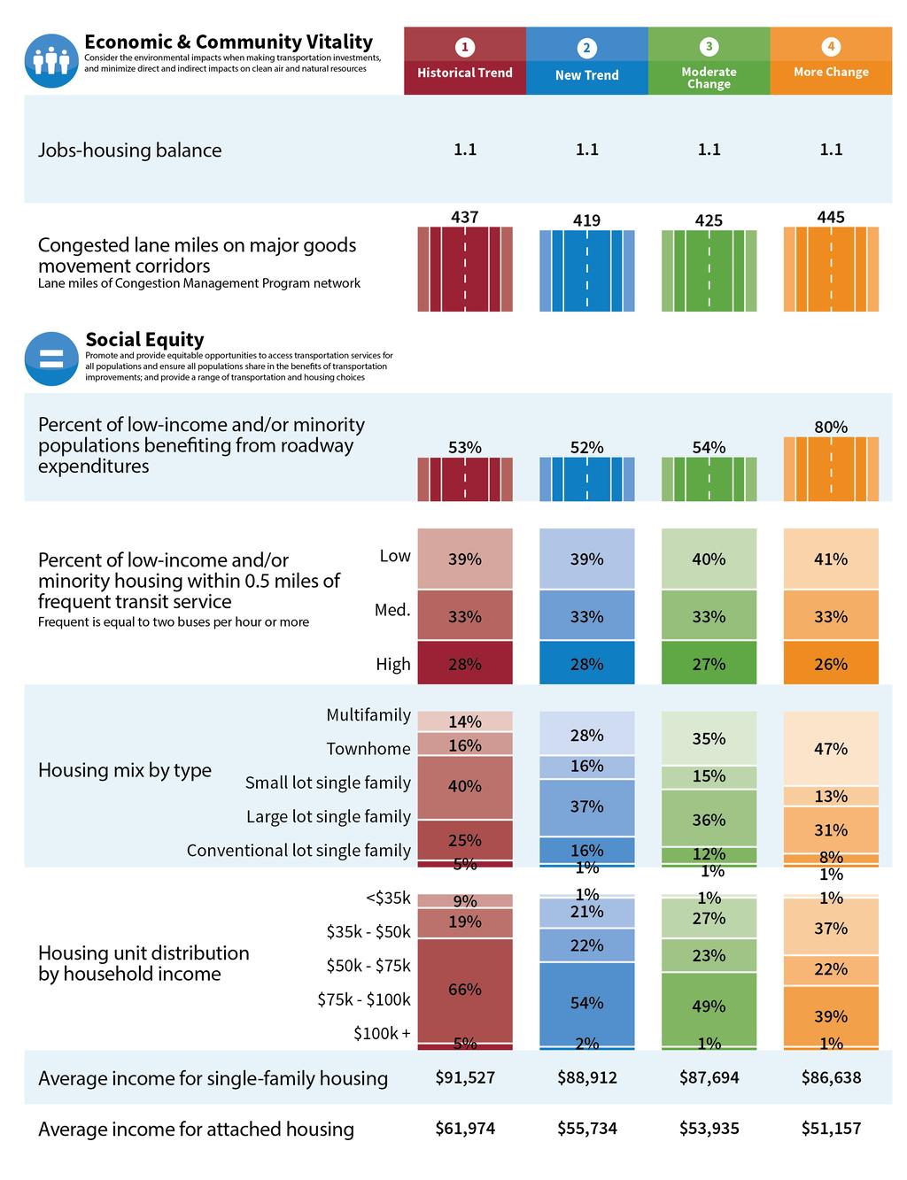
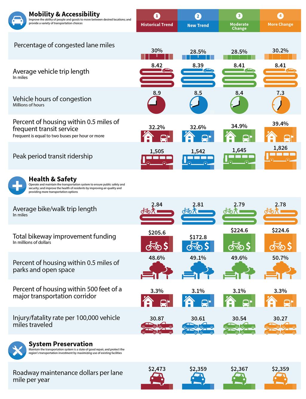
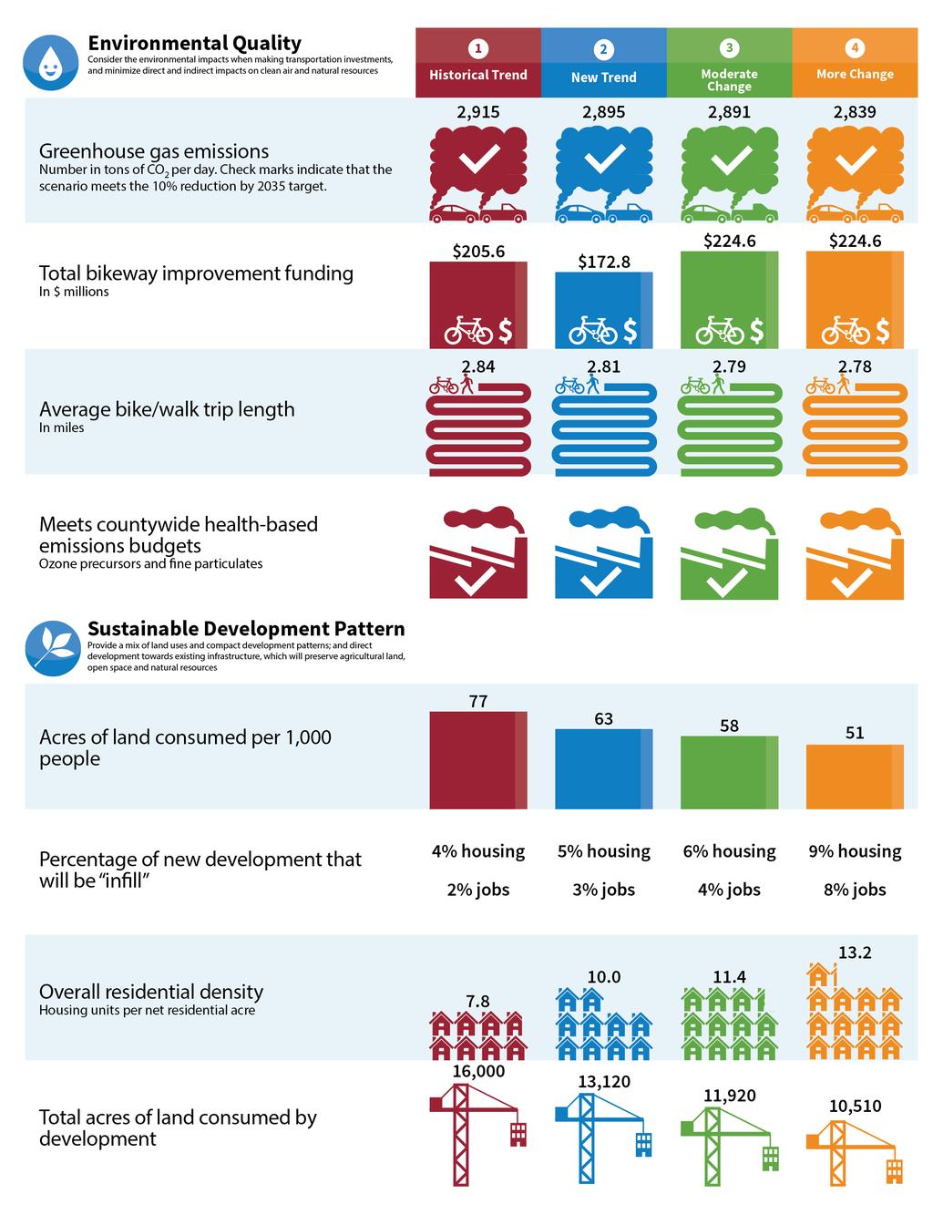
1 Valley Vision Stanislaus Workshop Help Shape Our Region s Future! Valley Vision Stanislaus is a long-range planning process that will link future land use with a framework for investment in roads, freeways, public transit, and bicycle and pedestrian infrastructure. At this stage in the process, StanCOG has prepared four growth scenarios with complementary transportation investments. StanCOG is seeking your input on which scenario you think best meets the region s needs. The Scenarios Historical Trend New Trend Pages include maps that show potential future development patterns for each scenario through 2035 so you can compare the different types of growth. Each presents future year 2035 conditions. Scenario 1 presents continued growth similar to past development patterns. Scenario 2 shows growth and development that conforms to the general plans of the county and cities. Scenario 3 presents a growth pattern with a greater emphasis on mixed-use and infill development. Scenario 4 takes the mixed-use emphasis of Scenario 3 even further by locating more growth within cities. How Do I Select a Scenario? Moderate Change More Change To help you select your preferred scenario, StanCOG has prepared comparisons between the scenarios based on various transportation and land-use performance measures. These comparisons are provided on pages 4-8. The four scenarios are consistently marked like the samples above. Our Schedule AUGUST 2013 NOW! StanCOG will hold three workshops and five city presentations (see back page) to present the four scenarios and get your feedback on a preferred scenario. SEPTEMBER 2013 The Policy Board will select a preferred scenario. NOVEMBER 2013 TO JANUARY 2014 The Valley Vision Stanislaus documents will be released and available for comment. MARCH 2014 END! StanCOG will hold a public hearing and the Policy Board will adopt the Valley Vision Stanislaus plan. Who is StanCOG? StanCOG is the Metropolitan Planning Organization (MPO) for the Stanislaus Region as designated by the Federal government, and the Regional Transportation Planning Agency (RTPA) as designated by the State of California. It is responsible for developing and updating a variety of transportation plans and for allocating Federal and State funds to implement them. StanCOG is directed by a board of Mayors, Cty Council Members and County Supervisors who work together to address regional issues. Select your preferred scenario at: 1
2 Land Use Patterns 1 Historical Trend Development Patterns Growth occurs adjacent to existing communities Complementary Uses Suburban, auto-oriented development Services and employment separated from housing Development Density New low-density housing Development occurs at lower end of allowed general plan densities Transit/Transportation Corridors Limited alternative transportation options Continued expansion of roadways 2 New Trend Development Patterns Growth occurs adjacent to existing communities or as infill Complementary Uses Mix of suburban and compact development Improved housing-type options Development Density Mix of large lot single-family housing and smaller lot single-family housing Development occurs at targeted general plan densities Transit/Transportation Corridors Increased availability of alternative modes of travel 2

3 3 Moderate Change Development Patterns Infill within downtowns and mixed-use neighborhoods Complementary Uses Compact development within mixeduse centers, and in new traditional neighborhoods Development Density New multi-family, mixed-use housing with a mix of smaller lot housing Development occurs at the upper end of allowed general plan densities Transit/Transportation Corridors Increased availability of alternative modes of travel 4 More Change Development Patterns Very limited expansion of existing community boundaries Infill within downtowns and mixed neighborhoods Complementary Uses Compact development in downtowns and in new traditional neighborhoods Development Density Greater percentage of multifamily, mixed-use housing, and duplex/ townhomes as new housing stock. Transit/Transportation Corridors Increased availability of alternative modes of travel 3
4 4
5 5
6 6

7 Valley Vision Stanislaus About What is Valley Vision Stanislaus? Valley Vision Stanislaus is a regional planning effort of StanCOG, Stanislaus County, and the Cities of Ceres, Hughson, Modesto, Newman, Oakdale, Patterson, Riverbank, Turlock, and Waterford. It is intended to improve the quality of life in our communities by expanding transportation, housing, and employment. Valley Vision Stanislaus is taking a big-picture look at how our communities can grow over time in a way that uses resources efficiently, protects existing communities, conserves farmland and open space, and supports our local economy. StanCOG, who is responsible for setting the transportation policy and priorities for the region, will use the results of Valley Vision Stanislaus to prepare the Regional Transportation Plan (RTP). Why are we doing this? The Federal government requires that MPOs such as StanCOG develop RTPs every four years to reflect current population, employment, and travel projections, as we as changes in local plans and regional transportation priorities. The State of California requires RTPs to coordinate transportation planning with regional housing and land use policies in order to reduce greenhouse gas emissions. Without an adopted RTP, the region would not be eligible for Federal and State funding for major transportation improvements. Valley Vision Stanislaus is also an opportunity to think about how we want our region to change and evolve over the next several years to meet our needs and reflect our values. Planning in advance of growth can result in better neighborhoods, more housing and transportation choices, and a higher quality of life for residents. 7


8 Valley Vision Stanislaus Upcoming Events August Patterson Community Workshop Wednesday, August 14th 6:30-8:30 PM City Council Chambers 1 Plaza Patterson, CA Waterford City Council Study Session Thursday, August 15th 5:30 PM 101 E Street Waterford, CA Turlock Planning Commission Presentation Thursday, August 15th 7:00 PM 156 S. Broadway, Yosemite Community Room Turlock, CA Oakdale Community Workshop Tuesday, August 20th 6:30 8:30 PM Gene Bianchi Community Center 110 South Second Avenue Oakdale, CA Ceres Community Workshop 6:30-830PM Tuesday, August 27th 2701 Fourth Street, Community Room Ceres, CA Ceres Council Presentation Monday, August 26th 5:30 PM 2701 Fourth Street Ceres, CA Hughson Council Presentation Monday, August 26th 7:00 PM 7018 Pine Street Hughson, CA Modesto Planning Commission Presentation Wednesday, August 28th 6:00 PM City-County Chambers th Street Modesto, CA 8
Prepared for the Citizens of Forsyth County by the City-County Planning Board
 Prepared for the Citizens of Forsyth County by the City-County Planning Board Bryce A. Stuart Municipal Building 100 East First Street, Winston-Salem, NC 27101 336.727.8000 www.cityofws.org/planning www.legacy2030.com
Roundtable Meeting #1
 MCTC 2018 Regional Transportation Plan/Sustainable Communities Strategy & Program Environmental Impact Report Roundtable Meeting #1 September 26, 2017 MCTC 2018 RTP / SCS & PEIR Presentation Overview:
CITY OF PUYALLUP. Background. Development Services
 CITY OF PUYALLUP Development Services 333 South Meridian Puyallup WA 98371 To: City Council From: Katie Baker, AICP, Planning Division Re: South Hill Neighborhood Plan Adoption Date: (Meeting date: February
Remi Mendoza City Planning Academy March 13, 2017
 Remi Mendoza City Planning Academy March 13, 2017 1 What is the General Plan? The 2030 General Plan 5-Year Update (2035 General Plan) Questions and Answers 2 Guidebook for development and growth Required
Blueprint Denver Task Force Meeting #
 Blueprint Denver Task Force Meeting #1 6.23.16 1. Welcome and Introductions Your name and affiliation Name 1 thing you love about Denver Name 1 thing you d change about Denver All in 30 seconds! Ready,
CHAPTER 1. Ms. Guajardo s Class - Central Elementary CH 1 1
 INTRODUCTION CHAPTER 1 Ms. Guajardo s Class - Central Elementary CH 1 1 1.1 SETTING South Centre City is a linear corridor south of Downtown Escondido paralleling Centre City Parkway and South Escondido
INDEPENDENCE BOULEVARD AREA PLAN. June 24, 2008
 INDEPENDENCE BOULEVARD AREA PLAN Public Meeting #1 June 24, 2008 Tonight s Agenda Introduction Welcome and Ground Rules Overview Presentation Purpose of the Plan What Brings Us Here? A Tour of the Corridor
Communities Plan. Parkland-Spanaway-Midland. LUAC Review of Draft Policies
 Parkland-Spanaway-Midland Communities Plan LUAC Review of Draft Policies Presented by: Tiffany O Dell, Senior Planner Planning & Public Works Tiffany.Odell@co.pierce.wa.us 253-798-6859 November 1, 2017
Economic Development & Housing Council Committee Comprehensive Plan Update September 20, 2005
 1 Economic Development & Housing Council Committee Comprehensive Plan Update September 20, 2005 Purpose To update the Committee on the ForwardDallas! Plan, including: Status Anticipated Products Public
TOD 101 CREATING LIVABLE COMMUNITIES WITH TRANSIT
 1 CREATING LIVABLE COMMUNITIES WITH TRANSIT What are transit Centered Communities? Benefits of Partnerships to Support and Implement What You Will Learn Portland s Pearl District Your Trainers Today Catherine
A. WHAT IS A GENERAL PLAN?
 I. Introduction A. WHAT IS A GENERAL PLAN? A general plan is the planning guideline for the future of a city. It contains goals and policies which regulate urban development, the protection of the natural
PUBLIC OPEN HOUSE HURONTARIO-MAIN CORRIDOR SECONDARY PLAN
 PUBLIC OPEN HOUSE HURONTARIO-MAIN CORRIDOR SECONDARY PLAN Tuesday, February 28, 2012 6pm 9pm 1 st Floor Atrium, City Hall 2 Wellington Street West, Brampton 1 POLICY FRAMEWORK The 2006 Provincial Growth
Broadway District Specific Plan. Community Workshop #2 February 23,2016
 Broadway District Specific Plan Community Workshop #2 February 23,2016 1 Agenda Introductions Project Progress Status Upcoming Milestones Emerging Framework Land Use Urban Design Circulation Infrastructure
Robbinsdale LRT Station. CDI Development Guidelines. August Overview
 Robbinsdale LRT Station August 2018 Overview The City of Robbinsdale may have the coolest opportunity site along the 13 mile stretch of the Bottineau LRT corridor / Blue Line extension. Located a block
LAND USE AMENDMENT DOWNTOWN COMMERCIAL CORE (WARD 7) MACLEOD TRAIL SE AND 5 AVENUE SE BYLAW 254D2017
 MACLEOD TRAIL SE AND 5 AVENUE SE BYLAW 254D2017") Page 1 of 10 EXECUTIVE SUMMARY This Land Use Amendment application seeks to redesignate a full downtown block (currently the YWCA site) from a Direct Control based on the CM-2 District (Land Use Bylaw
Page 1 of 10 EXECUTIVE SUMMARY This Land Use Amendment application seeks to redesignate a full downtown block (currently the YWCA site) from a Direct Control based on the CM-2 District (Land Use Bylaw
NEC of Central Avenue and Indian School Road
 NEC of Central Avenue and Indian School Road For this location, there are two applicable plans that provide guidance on development. The two plans include the Indian School Specific Plan (1991) and the
Silver Line CPAM UPDATE. Transportation and Land Use Committee October 20, 2016
 Silver Line CPAM UPDATE Transportation and Land Use Committee October 20, 2016 Purpose General Summary of TLUC Discussion Review of TLUC Recommended Transportation Other TLUC Recommendations Next Steps
Old Town Neighborhoods Plan. Choices Event Wednesday, December 9, 2015
 Old Town Neighborhoods Plan Choices Event Wednesday, December 9, 2015 Agenda 6:00 6:10 p.m. Welcome + Sign In 6:10 6:30 p.m. Presentation 6:30 8:00 p.m. Workshop + Open House Seeking your input on: Neighborhood
LEED-ND 101: Practical Strategies for Achieving Sustainability Goals. Travis Parker Lakewood Planning Director
 LEED-ND 101: Practical Strategies for Achieving Sustainability Goals Travis Parker Lakewood Planning Director Metro Vision Idea Exchange Oct 11, 2012 West Corridor Stations West Corridor Overview West
Hillsborough County MPO Transit Study. Citizens Team Workshop Wednesday, February 28 th, 2006 Hillsborough Community College - Brandon
 Hillsborough County MPO Transit Study Citizens Team Workshop Wednesday, February 28 th, 2006 Hillsborough Community College - Brandon What is the MPO Transit Study? An effort to look at the full range
Urban Planning and Land Use
 Urban Planning and Land Use 701 North 7 th Street, Room 423 Phone: (913) 573-5750 Kansas City, Kansas 66101 Fax: (913) 573-5796 Email: planninginfo@wycokck.org www.wycokck.org/planning To: From: City Planning
South Central Connecticut Region Plan of Conservation & Development 2018 Update. Municipal Planners
 South Central Connecticut Region Plan of Conservation & Development 2018 Update Municipal Planners July 28th, 2017 1 Introductions 2 Purpose of Today s Meeting Supplement data analysis with qualitative
2035 General Plan Update and Belmont Village Specific Plan. Joint Study Session with the City Council and Planning Commission April 12, 2016
 2035 General Plan Update and Belmont Village Specific Plan Joint Study with the City Council and Planning Commission April 12, 2016 Agenda 1. Welcome and Introductions 2. General Plan Update Status of
Silver Line CPAM UPDATE. Transportation and Land Use Committee October 14, 2016
 Silver Line CPAM UPDATE Transportation and Land Use Committee October 14, 2016 Purpose Recap Project History and Map Changes Provide Overview of CPAM Components Discuss Transportation Impacts Discuss Fiscal
Cumberland Region Tomorrow is a private, non-profit, citizen based regional organization working with Greater Nashville Regional Council
 Cumberland Region Tomorrow is a private, non-profit, citizen based regional organization working with Greater Nashville Regional Council and others in the public and private sectors, dedicated to planning
JANUARY 19, 2011 CENTRAL AVENUE-METRO BLUE LINE TRANSIT-ORIENTED DEVELOPMENT IMPLEMENTATION PROJECT COMMUNITY FORUM
 CENTRAL AVENUE-METRO BLUE LINE TRANSIT-ORIENTED DEVELOPMENT IMPLEMENTATION PROJECT COMMUNITY FORUM JANUARY 19, 2011 THE MARYLAND-NATIONAL CAPITAL PARK AND PLANNING COMMISSION PRINCE GEORGE S COUNTY PLANNING
ORANGE LINE TRANSIT NEIGHBORHOOD PLANS VAN NUYS NEIGHBORHOOD COUNCIL, PLUM COMMITTEE DEPARTMENT OF CITY PLANNING, CITY OF LOS ANGELES
 Photo: Mission Meridian(Moule & Polyzoides) ORANGE LINE TRANSIT NEIGHBORHOOD PLANS VAN NUYS NEIGHBORHOOD COUNCIL, PLUM COMMITTEE DEPARTMENT OF CITY PLANNING, CITY OF LOS ANGELES JULY 18, 2018 Project partially
DOMINION BOULEVARD CORRIDOR STUDY AND ECONOMIC DEVELOPMENT STRATEGIC PLAN A MODEL FOR CHESAPEAKE S FUTURE
 DOMINION BOULEVARD CORRIDOR STUDY AND ECONOMIC DEVELOPMENT STRATEGIC PLAN A MODEL FOR CHESAPEAKE S FUTURE Overview I. Draft Plan Process II. Draft Plan Overview a. Market Analysis b. Master Land Use Plan
Transportation Land Use Integration & Regional Planning. Don Kostelec, AICP Senior Planner, Louis Berger Group February 1, 2010
 Transportation Land Use Integration & Regional Planning Don Kostelec, AICP Senior Planner, Louis Berger Group February 1, 2010 Transportation Land Use Integration DOT-HUD-EPA Sustainable Communities Initiative
Gold Line Bus Rapid Transit Transit Oriented Development (BRTOD) Helmo Station Area Plan
 Helmo Station Area Plan") Appendix F Gold Line Bus Rapid Transit Transit Oriented Development (BRTOD) Helmo Station Area Plan Introduction and Purpose of the Plan The Gold Line Bus Rapid Transit facility is an eleven-mile dedicated
Appendix F Gold Line Bus Rapid Transit Transit Oriented Development (BRTOD) Helmo Station Area Plan Introduction and Purpose of the Plan The Gold Line Bus Rapid Transit facility is an eleven-mile dedicated
S A C R A M E N T O C O U N T Y JACKSON HIGHWAY & GRANT LINE EAST VISIONING STUDY
 JACKSON HIGHWAY & GRANT LINE EAST S A C R A M E N T O C O U N T Y P L A N N I N G D E P A R T M E N T SUMMARY AND WORKBOOK November 19, 2008 History of the Visioning Study Sacramento County has two growth
CDAC. Update: Downtown Dartmouth Update: CDAC July 25 th Motion
 CDAC Update: Downtown Dartmouth Update: CDAC July 25 th Motion 2018-10-24 Downtown Dartmouth Plan Open House October 22, 2018 6:00 pm Open House 6:30 pm Presentation + Q&A 7:20 pm Open House 8:30 pm Close
Implementation Guide Comprehensive Plan City of Allen
 Implementation Guide 2030 Comprehensive Plan City of Allen DRAFT 2015 Implementation Guide Allen 2030 Comprehensive Plan INTRODUCTION The Comprehensive Plan serves as a guide for the growth and development
REVIEW AND EVALUATION OF REGIONAL LAND USE
 REVIEW AND EVALUATION OF REGIONAL LAND USE AND TRANSPORTATION SCENARIOS #220831 Environmental Justice Task Force October 7, 2014 VISION 2050 Process Development of Guiding Vision for Land Use and Transportation
of ZONING OVERHAUL
 City City of Somerville of ZONING OVERHAUL www.somervillezoning.com November 27, 2018 TONIGHT S AGENDA 1. Recreational Marijuana 2. Answering Alderman questions 1. Mapped Densities Across Somerville Mapped
Gary & Regional Investment Project. October 27, Creating Tomorrow Today Comprehensive Regional Plan - NIRPC
 Creating Tomorrow Today 2040 Comprehensive Regional Plan Gary & Regional Investment Project October 27, 2010 Creating Tomorrow Today - 2040 Comprehensive Regional Plan - NIRPC What is NIRPC? - Northwestern
SAN RAFAEL GENERAL PLAN 2040 INTRODUCTION AND OVERVIEW
 SAN RAFAEL GENERAL PLAN 2040 INTRODUCTION AND OVERVIEW Steering Committee Presentation February 14, 2018 Purpose of General Plan Guide land use and development decisions Coordinate transportation, infrastructure,
Official Plan Review
 Official Plan Review Summary Report - The Built Environment August 2014 Part 1: Introduction Planning for a healthy, prosperous and sustainable community is an important goal for our municipality. From
D-O LRT Zoning Discussion. Chapel Hill Boards & Commissions October 16, 2017
 D-O LRT Zoning Discussion Chapel Hill Boards & Commissions October 16, 2017 Update on Overall D-O LRT Station Area Initiative Objectives Design and educate on principles of Good Transit-Oriented Development
DOWNTOWN AREA PLAN. June 9, 2009
 DOWNTOWN AREA PLAN June 9, 2009 Issues Identified by Councilmembers Overlap with Southside Plan Southwest Residential Area & Herrick Shadows & Residential Areas Shadows on Streets & Canyon Effect Transit
Plano Tomorrow Vision and Policies
 Plano Tomorrow Vision and Policies PLANO TOMORROW PILLARS The Built Environment The Social Environment The Natural Environment The Economic Environment Land Use and Urban Design Transportation Housing
TRANSIT ORIENTED DEVELOPMENT PINELLAS COUNTY MPO LIVABLE COMMUNITIES INITIATIVE PINELLAS COUNTY COMPREHENSIVE PLAN AMENDMENTS
 PINELLAS COUNTY MPO LIVABLE COMMUNITIES INITIATIVE MODEL LAND DEVELOPMENT CODE TRANSIT ORIENTED DEVELOPMENT PINELLAS COUNTY COMPREHENSIVE PLAN AMENDMENTS MPO Livable Communities Initiative Goal: Improve
South Davis County COMMUNITY SPOTLIGHT
 South Davis County COMMUNITY SPOTLIGHT Davis/SLC Community Connector Bus Rapid Transit line connecting SLC & Davis County RTP Phase 1 Project Generate 3,100 average weekday riders Relieve congestion on
LAND USE DESIGNATIONS AND ZONING CLASSIFICATIONS
 LAND USE DESIGNATIONS AND ZONING CLASSIFICATIONS One of the most significant issues addressed within the community plan process is land use. How land is utilized within a community directly affects the
Citizen Comment Staff Response Staff Recommended Revision Planning Committee
 Citizen Comment Staff Response Staff Recommended Revision Planning Committee Area No. 1: Owner desires retail land uses. Area No. 1a: Owner of two small parcels adjacent to Area No. 1 desires retail land
City Council Special Meeting AGENDA ITEM NO. C.
 City Council Special Meeting AGENDA ITEM NO. C. DATE: 01/04/2019 TO: Honorable Mayor and City Council Members SUBJECT: Transit Villages Specific Plan project Study Session (Development Services Director
Gratigny Parkway East Extension Project Development & Environment (PD&E) Study
 Study") Gratigny Parkway East Extension Project Development & Environment (PD&E) Study Session 4: Presentation of Charrette Results December 8, 2010 MDX Work Program #: 92407 ETDM#: 11500 Project Location & Description
Gratigny Parkway East Extension Project Development & Environment (PD&E) Study Session 4: Presentation of Charrette Results December 8, 2010 MDX Work Program #: 92407 ETDM#: 11500 Project Location & Description
Natomas Vision Plan and PLNP
 Natomas Vision Plan 20030171 and PLNP2014-00172 Department of Community Development Planning and Environmental Review Leighann Moffitt Sub-Agenda 1. Staff Presentation Leighann Moffitt, County Planning
CITY OF ALHAMBRA DEVELOPMENT SERVICES DEPARTMENT 111 S. First Street. Alhambra, CA (626) FAX (626)
 FAX (626)") CITY OF ALHAMBRA DEVELOPMENT SERVICES DEPARTMENT 111 S. First Street. Alhambra, CA 91801 (626) 570-5030 - FAX (626) 458-4201 NOTICE OF PREPARATION TO: SUBJECT: Agencies, Organizations and Interested Parties
CITY OF ALHAMBRA DEVELOPMENT SERVICES DEPARTMENT 111 S. First Street. Alhambra, CA 91801 (626) 570-5030 - FAX (626) 458-4201 NOTICE OF PREPARATION TO: SUBJECT: Agencies, Organizations and Interested Parties
Growth Management Planning in the Central Puget Sound Region. Today s Presentation. Puget Sound Region. New Partners for Smart Growth
 Growth Management Planning in the Central Puget Sound Region New Partners for Smart Growth Denver, CO January 2006 Today s Presentation Regional growth management in central Puget Sound, WA Regional geographies
2040 LUP is a part of the Comprehensive Plan and carries the same legal authority. Economic Challenges
 1.1. Guiding Anchorage s Growth Where will new residents settle over the next two decades? Where will people work, shop, and play? Will there be enough room to grow? How will Anchorage look? Will growth
North Downtown Specific Plan MEMORANDUM
 North Downtown Specific Plan MEMORANDUM MEETING DATE: November 13, 2017 TO: Members of the North Downtown Specific Plan Advisory Committee FROM: Jeanine Cavalli, Senior Planner SUBJECT: Materials for the
TOWN OF NEW CASTLE - Master Plan Update
 Our Presentation Today (1) Recap the Master Planning Process To Date (2) Present the Outline of the Master Planning Work Plan (3) Present the Calendar for the Master Plan (4) Outline the scope of a Downtown
The Floyds Fork Area Study A Framework for Growth
 The Floyds Fork Area Study A Framework for Growth 2 21 st Century Parks Master Plan: The Fork 3 Neighborhood Development Area Policy Recommendations 1. Create incentives to promote infill of existing development
WAC #7 3/14/14. Coachella General Plan Update
 WAC #7 3/14/14 Coachella General Plan Update Agenda 2 Introductions Public Draft General Plan Overview and Discussion of Next Steps Implementation and Evaluation Health Element Process Evaluation (discussion)
Cobb County Design Guidelines Mableton Parkway & Veterans Memorial Highway Community Design Workshop January 12, 2017
 Community Design Workshop January 12, 2017 Agenda Opening Remarks / Introductions Scope of Work Existing Conditions Key Issues / Opportunities VPS Summary Draft Vision & Goal Statement Implementation Concepts
Mount Pleasant Comprehensive Plan Public Open House Meeting. June 5, 2018
 Mount Pleasant Comprehensive Plan Public Open House Meeting June 5, 2018 The Planning Team Town Staff Liz Boyles - Principal Planner Brad Morrison - Transportation Director Christiane Farrell Assistant
PINE CURVE REZONING. BACKGROUND Purchased as two parcels in 2001 and 2002
 BACKGROUND Purchased as two parcels in 2001 and 2002 WHAT THE PROJECT IS AND IS NOT A Rezoning establishes the land use standards for Annexed and Zoned Greater Downtown District Historic Center September
Tyvola & Archdale Transit Station Area Plan. June 5, 2008
 Tyvola & Archdale Transit Station Area Plan Second Public Meeting June 5, 2008 Presentation Outline 1. Purpose and Process 2. Station Area Overview 3. Plan Recommendations 4. Comments Received and Proposed
Chapter #3 LAND USE AND SCENARIO PLANNING
 Chapter #3 LAND USE AND TABLE OF CONTENTS 3.0 Land Use and Scenario Planning...3-1 3.1 Introduction IMAGINE 2040...3-1 3.2 Background...3-3 3.2.1 4D Analysis...3-3 3.3 Imagine 2040 Scenario Planning...3-7
September 28, 2017 Wentworth Avenue (CR 8) Sidewalk Improvements Open House
 Sidewalk Improvements Open House") TIME Anytime from 5:00 PM to 7:00 PM LOCATION City Hall Council Chambers Learn about the project Speak with project representatives Provide input YOU RE INVITED! September 28, 2017 Wentworth Avenue (CR
TIME Anytime from 5:00 PM to 7:00 PM LOCATION City Hall Council Chambers Learn about the project Speak with project representatives Provide input YOU RE INVITED! September 28, 2017 Wentworth Avenue (CR
Chapter 3: Land Use and Local Planning
 3.1 Chapter 3: Land Use and Local Planning 2040 3.2 Chapter 3: Land Use and Local Planning CONTENTS Introduction 3.3 Coordinating Thrive MSP 2040 and Transportation Policy Plan 3.6 Coordination of Regional
North Fair Oaks Community Plan Summary and Information
 North Fair Oaks Community Plan Summary and Information WHAT IS THE NORTH FAIR OAKS COMMUNITY PLAN? The North Fair Oaks Community Plan is part of the San Mateo County General Plan, and establishes policies
Corridor Vision. 1Pursue Minnehaha-Hiawatha Community Works Project. Mission of Hennepin County Community Works Program
 1Pursue Minnehaha-Hiawatha Community Works Project Minnehaha-Hiawatha Community Works is a project within the Hennepin Community Works (HCW) program. The mission of the HCW program is to enhance how the
Public Meeting Final Recommendations August 8, 2013
 Public Meeting Final Recommendations August 8, 2013 Meeting Agenda 1. Existing Conditions 2. Plan Building Blocks & Process 3. The Plan Policies 4. What we heard 5. Next Steps Existing Conditions Existing
CITY OF SACRAMENTO GENERAL PLAN. UC Davis ESP 171 Urban and Regional Planning April 21, 2011
 CITY OF SACRAMENTO GENERAL PLAN UC Davis ESP 171 Urban and Regional Planning April 21, 2011 1 OUTLINE Background Growth and Change Placemaking Sustainability and Climate Change Economic Development 2 City
Making TOD Work in the Heart of Suburban Sprawl
 Making TOD Work in the Heart of Suburban Sprawl Rocky Mountain Land Use Institute March 6, 2009 Speakers Ben Herman, FAICP, Principal Clarion Associates Darcie White, AICP, Principal Clarion Associates
Isabel Neighborhood Plan: Alternatives
 Isabel Neighborhood Plan: Alternatives Presented by: Lori Parks, Associate Planner February 2, 2015 Agenda 1. Background on BART to Livermore 2. Isabel Neighborhood Plan 3. Alternative Scenarios 4. General
Denver Moves: Transit Task Force
 Insert transit picture Denver Moves: Transit Task Force Meeting #8 October 5, 2017 1. Welcome & Introductions Opening remarks and housekeeping Task Force and audience introductions Upcoming events and
13 THORNHILL YONGE STREET STUDY IMPLEMENTATION CITY OF VAUGHAN OPA 669 AND TOWN OF MARKHAM OPA 154
 13 THORNHILL YONGE STREET STUDY IMPLEMENTATION CITY OF VAUGHAN OPA 669 AND TOWN OF MARKHAM OPA 154 The Planning and Economic Development Committee recommends the adoption of the recommendations contained
Atlanta BeltLine Corridor Environmental Study. Scoping Meeting August 2008
 Atlanta BeltLine Corridor Environmental Study Scoping Meeting August 2008 What Will We Be Discussing Today? Study Overview - How Did We Get Here? - What Is the Study About? - Who Is Involved? - Where Is
Planning Commission Special Workshop. October 25, 2018
 Planning Commission Special Workshop October 25, 2018 Composition of Committee Steven Neeves, Chair Marvin Heyd, Vice-Chair Joe Burch Pam Creech Ruth Anne Ellis Rick Elliott Christy Everett Chris Hennigan
EXPO LINE COMMUNITY WORKSHOPS NOVEMBER 27 TH & DECEMBER 3 RD Los Angeles Department of City Planning
 EXPO LINE COMMUNITY WORKSHOPS NOVEMBER 27 TH & DECEMBER 3 RD 2012 Los Angeles Department of City Planning Agenda for Tonight Open House 6:00 to 6:15pm Presentation and Questions 6:15 to 6:50 Small Group
Complete Streets in Lancaster County
 Complete Streets in Lancaster County PRESENTED BY: Robert Bini, AICP Director for Transportation Planning November 14, 2017 Lancaster County is a growing county of over 534,000 and the bottom line is...
Tyvola & Archdale Transit Station Area Plan. May 15, 2008
 Tyvola & Archdale Transit Station Area Plan First Public Meeting May 15, 2008 Presentation Outline 1. Purpose and Process 2. Station Area Overview 3. Plan Recommendations Vision Land Use Transportation
Future Proposed Development
 Future Proposed Development on and around Link light rail s Capitol Hill Station Meeting September 24, 2012 Tonight s Agenda 6:00 pm Open House 6:30 pm Introductions Richard Conlin, City of Seattle Councilmember/Sound
Broken Arrow Comprehensive Plan Update Public Workshop Meeting #3 January 23,
 Broken Arrow Comprehensive Plan Update Public Workshop Meeting #3 January 23, September 25,2018 2018 26 April 2016 AGENDA 1. Status Presentation - Charrette Recap - Proposed Vision Framework - Preliminary
Chapter 1.0 Introduction
 Chapter 1.0 Introduction 1.1 Background The North Metro commuter rail line is part of the RTD FasTracks regional transit system expansion program to build more than 100 miles of rail transit throughout
MORRISVILLE TRANSPORTATION PLAN TOWN COUNCIL PRESENTATION AUGUST 22, 2017
 TOWN COUNCIL PRESENTATION AUGUST 22, 2017 SCENARIO PLANNING CORRIDORS Town Hall Drive Baseline + 2 McCrimmon Parkway Baseline + 2 NC 54 Baseline + 2 7 subregion model runs determining carrying capacity
TONIGHT S PURPOSE INFORMATION SESSION CANORA & WEST JASPER PLACE SIDE STREETS CONCEPT PLANNING STUDY. Share draft side streets concept plan
 TONIGHT S PURPOSE Share draft side streets concept plan INFORMATION SESSION Share information and answer questions Tuesday, December 1, 2015 Drop-In 5:30 8:00 PM West Jasper/Sherwood Community Hall TONIGHT
CHAPTER 7: VISION AND ACTION STATEMENTS. Noble 2025 Vision Statement
 CHAPTER 7: VISION AND ACTION STATEMENTS This chapter presents the vision, policy and action statements that transform the comprehensive planning study, an analysis of Noble s past, future trends and community
Street Flooding Mitigation Plan KYOVA Interstate Planning Commission. Presented to AMPO National Conference October 18, 2017
 Street Flooding Mitigation Plan KYOVA Interstate Planning Commission Presented to AMPO National Conference October 18, 2017 Saleem Salameh, Ph.D., P.E., M.ASCE Chet Parsons, AICP CTP Agenda: Background
Danvers High Street I-1 District Study
 Danvers High Street I-1 District Study Presentation of Final Recommendations Planning Board Presentation June 26 th, 2018 1 Introductions Metropolitan Area Planning Council Sam Cleaves AICP, Principal
Roosevelt Corridor. R e i n v e s t m e n t P l a n. Public Meeting Gilbert Elementary School May 12, :00 pm
 Roosevelt Corridor R e i n v e s t m e n t P l a n Public Meeting Gilbert Elementary School May 12, 2009 6:00 pm Agenda 6:00 6:10 6:25 6:40 6:55 7:00 Opening Comments Councilwoman Jennifer V. Ramos District
PINE CURVE REZONING. Property does not meet criteria for open space preservation and is not a candidate for a park
 PINE CURVE REZONING BACKGROUND Purchased as two parcels in 2001 and 2002 Annexed and Zoned Greater Downtown District Historic Center September 25, 2002 and October 7, 2002 WHAT THE PROJECT IS AND IS NOT
Horizon 2035 Land Use and Transportation Element
 CITY OF SUNNYVALE Horizon 2035 Land Use and Transportation Element City Council Study Session March 7, 2017 Overview General Plan Context Mixed Use Villages Transportation Mode & Parking General Plan Policy
Prosperity Hucks Area Plan. Transportation and Planning Committee May 11, 2015
 Prosperity Hucks Area Plan Transportation and Planning Committee May 11, 2015 Presentation Outline 1. Background and Location 2. Community Dialog Process 3. Activity Center Recommendations 4. Wedge Recommendations
ROBBINSDALE LRT STATION CDI DEVELOPMENT GUIDELINES
 August 2018 OVERVIEW The City of Robbinsdale has a prime-opportunity site in the middle of the 13 mile stretch of the Bottineau LRT corridor / Blue Line extension. Robbinsdale offers a prominent, vital,
The Auburn Plan Designing the Future of Auburn February 28, 2005
 The Auburn Plan Designing the Future of Auburn February 28, 2005 Block-by-Block Bicycle Tour Aerial survey Focus Group Meetings September 7 and 8 Design Workshops October 11, 14, and 21 Revitalization
DRAFT PLAN PRESENTATION
 DRAFT PLAN PRESENTATION 1.23.2018 AGENDA Process Project Schedule Results from Visioning Workshop Draft Plan Highlights Concept Plans Feedback Next Steps PROJECT SCHEDULE KICK-OFF WORKSHOP August 29 th
Tri-County Transportation & Land Use Study. Steering Committee Meeting May 14, 2009
 Tri-County Transportation & Land Use Study Steering Committee Meeting May 14, 2009 Agenda Recap of Study Goals and Objectives Update on CV Land Use Model: Business as Usual (BAU) Growth Scenario Pros vs
Planning Commission Report
 Planning Commission Report To: From: Subject: Planning Commission Meeting: January 6, 2016 Agenda Item: 8-B Planning Commission David Martin, Planning & Community Development Director Introduction to the
Summary Community Workshop #1 Fruitvale San Antonio Senior Center Monday, March 23, :00-9:00 p.m.
 Summary Community Workshop #1 Fruitvale San Antonio Senior Center Monday, March 23, 2009 7:00-9:00 p.m. Workshop Format and Process The City of Oakland is preparing a Specific Plan that will help define
Preliminary Plan Framework: Vision and Goals
 Preliminary Plan Framework: Vision and Goals Draft: May 2015 Introduction Since the Town of Milliken s comprehensive plan was last updated in 2010, the community was heavily impacted by the 2013 flood,
EAST SELKIRK SECONDARY PLAN
 EAST SELKIRK SECONDARY PLAN The Regional Planning Context West St. Paul St. François Xavier Headingly Cartier Rockwood Stonewall Rosser Winnipeg St. Andrews St. Clements Selkirk Springfield Taché East
RESEDA - WEST VAN NUYS COMMUNITY PLAN UPDATE WORKSHOP
 Welcome Agenda 6:00 P.M. to 8:00 P.M. Welcome Community Plan Update Overview Presentation Table Discussions: Preserving Residential Neighborhoods Commercial Corridors Mobility Parks and the Public Realm
Living in Albemarle County s Urban Places
 Living in Albemarle County s Urban Places ALBEMARLE COUNTY, VIRGINIA A Closer Look at Albemarle s Approach to Managing Growth and Creating Quality Urban Environments www.albemarle.org Page 2 Living in
LAND USE MEADOWS PLANNING AREA
 LAND USE MEADOWS PLANNING AREA I. Profile of Meadows Planning Area A. Location Meadows Planning Area is delineated by I-5 on the north, the Nisqually Bluffs representing the growth boundary on the east,
NOTICE OF PREPARATION OF AN ENVIRONMENTAL IMPACT REPORT AND SCOPING MEETING FOR THE WEST BROADWAY SPECIFIC PLAN COMMENT PERIOD
 DATE: July 11, 2018 TO: FROM: RE: Interested Persons Tom Buford, Principal Planner Community Development Department NOTICE OF PREPARATION OF AN ENVIRONMENTAL IMPACT REPORT AND SCOPING MEETING FOR THE WEST
1.0 Introduction. Purpose and Basis for Updating the TMP. Introduction 1
 1.0 Introduction The Town of Castle Rock is situated between the metropolitan areas of Denver and Colorado Springs, amidst a unique terrain of rolling hills, mesas, ravines, and waterways. Like many Front