ATTACHMENT 2: Official Plan Amendment No. 54
|
|
|
- Reginald Small
- 6 years ago
- Views:
Transcription
1 ATTACHMENT 2: Official Plan Amendment No. 54 AMENDMENT NUMBER 54 TO THE OFFICIAL PLAN FOR THE CORPORATION OF THE CITY OF GUELPH: GUELPH INNOVATION DISTRICT SECONDARY PLAN AMENDMENT PART A - THE PREAMBLE INDEX The Preamble provides an explanation of the amendment including the purpose, background, location, basis and summary of the policies and public participation, but does not form part of this amendment. PAGE Title and Components... 1 Purpose... 2 Background... 2 Location... 4 Basis of the Amendment... 5 Summary of Changes to the Official Plan... 5 Public Participation... 6 PART B - THE AMENDMENT The Amendment describes the additions, deletions and/or modifications to the Official Plan of the City of Guelph, which constitute Official Plan Amendment Number 54. PAGE Format of the Amendment... 9 Implementation and Interpretation... 9 Details of the Amendment... 9 ITEMS 1 and 2 Amendments to the Policies... 9 ITEM 3 Addition of new Section 11.2 entitled Guelph Innovation District Secondary Plan ITEMS 4 10 Amendments to Schedules PART C - THE APPENDIX The Appendix is contained under separate cover. The Appendix does not form part of this amendment, but contains background information relevant to the amendment. PART A THE PREAMBLE TITLE AND COMPONENTS This document is entitled Guelph Innovation District Secondary Plan Amendment and will be referred to as Amendment 54. Part A - The Preamble provides an explanation of the amendment including the purpose, background, location, basis of the amendment, 1
2 summary of changes to the Official Plan and public participation, but does not form part of this amendment. Part B The Amendment forms Amendment 54 to the Official Plan for the City of Guelph and contains a comprehensive expression of the new, deleted and amended policy and includes revised Official Plan Schedules and new Schedules within the Guelph Innovation District Secondary Plan policy section. PURPOSE The purpose of Amendment 54 is to incorporate the GID Secondary Plan into the City s Official Plan by deleting the existing land use policies that apply to the GID lands and adding a new Section to the Official Plan that includes the new policies, schedules and corresponding definitions for the GID Secondary Plan. Specifically, Amendment 54: Incorporates the Guelph Innovation District Secondary Plan into the Official Plan by adding a new subsection to the Secondary Plan Chapter including policies and Schedules; Removes Official Plan policies that refer to the need for a planning study for the former Guelph Correction centre lands; and Revises existing Schedules to incorporate the new Guelph Innovation District Secondary Plan policies and associated Schedules into the Official Plan. BACKGROUND The City of Guelph initiated the preparation of a Secondary Plan for the Guelph Innovation District (GID) in early The majority of the lands are currently designated as Special Study Area by the City s Official Plan, requiring the completion of a planning study to examine future land uses, servicing, phasing of development, transportation and impact assessment on natural heritage features and cultural heritage resources. There are also a number of other land use designations within the GID Secondary Plan area which are proposed to be carried forward (i.e. existing service commercial and industrial designations) or are proposed to be redesignated (i.e. major institutional). The Secondary Plan implements the City s Official Plan policies. The Secondary Plan was completed in three phases. Phase I and II The Phase I Background Report and Phase II Land Use Concepts Report were completed in 2005, through the consulting services of planningalliance. In April 2007 Council directed staff to use the York District Preferred Land Use Scenario contained in the Phase II report as the basis for the development of a final land use strategy for the GID. The preferred land use concept recognizes the existing employment uses at the City s Waste Resource Innovation Centre, Cargill Meat Solutions, PDI (Polymer Distribution Inc.) and a variety of existing commercial uses along York Road, Victoria Road S. and Watson Parkway S. In addition, the residential uses south of Stone Road East, west of Watson Road South are recognized. The land use scenario focuses on additional employment lands, with institutional uses recommended for the former Guelph Correction Centre lands. The Province is the major landowner within the GID and has been working with the City in coordinating work to reposition the lands since the closure of the former institutional uses. In 2007, the City paused work on the GID to provide the Province with an opportunity to conduct its own research and public consultation process. This work culminated in the release of a report completed by Authenticity for the Province which presents a mixed use business park, live/work development scenario for the lands. 2
3 Phase III In April 2008, two hybrid land use concepts for the area were presented to the public at an urban design charrette which drew upon elements from both the Phase II Land Use Concept Report and Authenticity Report. The hybrid introduced the concept of an urban village on the west side of the Eramosa River in the vicinity of the Turfgrass Institute building, with the majority of future development still focused on employment uses. Employment mixeduse was recognized on the west side of the Eramosa River, east of the proposed urban village, while industrial uses were located on the east side of the Eramosa River, recognizing Cargill Meat Solutions and the Waste Resource Innovation Centre. Neighbourhood commercial centres and service commercial uses were identified at the northern corners of the site recognizing existing land uses. The lands of the former Guelph Correction Centre continued to be shown as institutional. Two options were proposed on the southeast corner residential and industrial employment. An information session was held with landowners south of Stone Road on the process and provided an opportunity to share views regarding the future development of the area. Work was paused during to allow the City s Economic Development Department to complete a strategic plan for the Guelph Agri-Innovation Cluster and to consider governance models for the development of the lands. Since the initiation of the Secondary Plan a number of strategic municipal documents have been completed including the Community Energy Initiative, Prosperity 2020, Strategic Plan for the Guelph Agri-Innovation Cluster, and the City of Guelph Local Growth Management Strategy. In addition, the City has revised its Official Plan in response to the Provincial Growth Plan for the Greater Golden Horseshoe and has adopted a Natural Heritage System as part of the City s Official Plan. The strategic importance of these lands has grown as a vital means to enable the City to meet its sustainability goals and objectives included in the above strategic initiatives. A community workshop was held on June 18, 2009 to present the work completed along with connections to the above initiatives. A Council Information Session on July 19, 2011 was held to discuss alternative designs for the Guelph Innovation District and the potential use of a Development Permit System (DPS) as the planning implementation mechanism for the final design. The Council session was followed by a public design workshop on September 15, 2011 that presented two design scenarios for the lands which were a composite of potential design elements. On October 18, 2011 an all day design charrette was held by invitation for city and consultant experts to consider feedback from the public design workshop and forge a consensus on what design elements should be carried forward in a preferred design scenario. In December 2011 the preferred design vision, principles and implementation strategy was released and subsequently approved by Council with a few changes on January 30, The work included an analysis of design precedents, public feedback on potential design elements, and a design charrette. A design booklet entitled Guelph Innovation District Recommended Option Booklet, was produced. This work was approved as support for the development of the Secondary Plan. 3

4 The draft Secondary Plan was released on October 15, 2012, followed by a public open house on November 28, Draft Official Plan Amendment No. 54 was released on November 7, 2013 and Council held a Statutory Public Meeting in accordance with the Planning Act on December 2, Following the public meeting, staff reviewed the submissions received and met with affected landowners to resolve the issues which has resulted in the final version of OPA 54. The GID Secondary Plan policies amend the current 2001 Official Plan and build on the Local Growth Management Strategy and Official Plan Update (OPA 39, OPA 42 and OPA 48). The Secondary Plan references and enhances the policies introduced through the Official Plan Update, including directions from OPA 42, the City s Natural Heritage System. LOCATION The lands subject to Amendment 54 are shown on Figure 1 below: Figure 1 4
5 BASIS OF THE AMENDMENT Amendment 54 amends the existing 2001 Official Plan and sets out policies for the Guelph Innovation District. It addresses the necessary changes to ensure that the City s policies and mapping, related to the Guelph Innovation District, conform with recent amendments to the City s Official Plan as a result of the City s Official Plan update process, including growth plan needs and other matters of provincial interest. The basis for the policy and mapping amendments come from the draft Guelph Innovation District Secondary Plan along with a number of policy documents and initiatives as summarized in the Background Section and consideration of public stakeholder input. SUMMARY OF CHANGES TO THE OFFICIAL PLAN The following is a summary of OPA 54: Guelph Innovation District Secondary Plan Policies The purpose of Amendment 54 is to incorporate the GID Secondary Plan into the City s Official Plan by deleting the existing land use policies that apply to the GID lands and adding a new Section to the Official Plan that includes the new policies, schedules and corresponding definitions for the GID Secondary Plan. The policies of this new section begin with the guiding vision, principles and objectives for the GID, formulated as part of an extensive public engagement process. Other policies address: natural and cultural heritage; energy, servicing and stormwater; mobility; the public realm; land use and built form; and interpretation and implementation. The policies generally follow the structure of the Official Plan Update (OPA 42 and 48) and make references to and enhance the policies of the Official Plan. Definitions and policies are on occasion repeated, given the status of OPA 42 and OPA 48 which are under appeal to the OMB. The section contains a detailed set of land use and development policies that guide all future development within the GID plan area; support conservation, protection and enhancement of the natural heritage system and cultural heritage resources; promote best practises for sustainable infrastructure and community design working towards carbon neutrality; identify collector road alignments and active transportation opportunities; and provide a high level urban design direction to guide the creation of a unique and memorable place. The policies conclude with a description of the actions and tools required to implement the plan. Schedules New Schedules have been included as part of the Guelph Innovation District Secondary Plan regarding Mobility, Land Use, Built Form Elements, and Block Plan Areas. A number of amendments are made to the existing Official Plan schedules to recognize the completion and integration of the Guelph Innovation District Secondary Plan. General Modifications In order to integrate the GID Secondary Plan into the Official Plan a number of changes are required to the general Official Plan schedules. In addition, policies that currently apply to the GID lands in the Official Plan are deleted because they are replaced by the GID Secondary Plan. Instead of revising the Official Plan Glossary, definitions are included within the GID Secondary Plan to add clarity to terms used in the policies that will eventually come into full force and effect with the approval of OPA 48. 5
6 PUBLIC PARTICIPATION The development of proposed Official Plan Amendment 54 has involved significant community stakeholder engagement that included public meetings, stakeholder meetings, open houses and workshops. Background Studies As outlined in the background section of the Official Plan Amendment, numerous studies and initiatives have been completed with public input in support of the preparation of Official Plan Amendment 54. The background studies include: PHASE ONE BACKGROUND REPORT 2005 Consultant Report March 17, 2005 York District Land Use + Servicing Study: Background Report PHASE TWO LAND USE CONCEPTS Consultant Report November 24, York District Land Use + Servicing Study: Phase II Report - Preferred 2005 Land Use Scenario Council Information Report January 18, 2007 York District Study Update CDES Report March 23, 2007 York District Land Use Study Process PROVINCIAL WORK 2007 Authenticity Report and Appendices November 19, York District Lands Guelph, Ontario 2007 PHASE THREE LAND USE AND SERVICING FINAL REPORT CDES Information Report July 11, 2008 Hybrid Land Use Plans and Phase III Update Council Information Report July 7, 2011 Guelph Innovation District Secondary Plan Update PBEE Committee Report December 12, GID Secondary Plan Preferred Design 2011 Consultant Booklet December 12, GID Recommended Option Booklet 2011 Council Report January 30, 2012 Supplementary Report: Stakeholder Feedback GID Secondary Plan Preferred Design PBEE Committee Report October 15, 2012 GID: Release of Draft Secondary Plan Council Report December 2, 2013 Statutory Public Meeting for Proposed Official Plan Amendment 54: Guelph Innovation District Secondary Plan Public Engagement A number of community engagement opportunities have been provided to stakeholders throughout the development of the Secondary Plan. The results of these opportunities have been considered in the various Committee and Council reports that received Council support on key foundational material leading to the development of OPA 54. The community engagement opportunities include: PHASE ONE BACKGROUND REPORT
7 First Public Consultation Meeting Royal Canadian Legion Introduce Project January 25, 2005 PHASE TWO LAND USE CONCEPTS Community Workshop Review and assist in development of land April 6, 2005 Turf Grass Institute use concepts Public Information Session Royal Canadian Legion Review Phase II February 1, 2007 PROVINCIAL AUTHENTICITY WORK Apr. Nov Special Information Introduce Provincial work to public April 12, 2007 Session: York District Lands Roundtable Meetings Four roundtable groups gather to develop ideas for York District lands Spring Summer 2007 A Research, Development and Innovation B Light Manufacturing, Office & Retail C Residential and Mixed-Use D Culture, Design and Creative Enterprise Public Town Hall 1 Public review of roundtable ideas for York June 18, 2007 District Public Town Hall 2 York District ideas presented based on roundtable work and public input from Public Town Hall 1 Meeting August 7, 2007 PHASE THREE LAND USE AND SERVICING FINAL REPORT Information Session for Landowners South of Stone Rd. Waste Innovation Centre Meeting Room Urban Design Charrette Update landowners south of Stone Rd. on the process and allow opportunity to share views Input into the development of land use concepts for the area, including range of land uses Dec. 10, 2007 April 5, 2008 ECONOMIC DEVELOPMENT PAUSE - STRATEGIC PLAN FOR THE GUELPH AGRI-INNOVATION CLUSTER Community Workshop Presented work completed and introduced June 18, 2009 key connections between the Secondary Plan, Local Growth Management Strategy, Community Energy Initiative, Natural Heritage Strategy, Prosperity 2020, and Strategic Plan for the Guelph Agri- Innovation Cluster Council Workshop Discussed draft vision, planning and design February 8, 2010 principles, and governance issues for the lands Community Design Two design scenarios presented which were Sept. 15, 2011 Workshop a composite of potential design elements to reflect in the development of the lands Design Charrette Design session held for city and consultants Oct. 18, 2011 to consider feedback from public design workshop and forge a consensus on design elements to carry forward in the preferred design. Public Open House Open house on draft Secondary Plan. November 28, 2012 In December 2011/January 2012 the preferred design, vision, principles and implementation approach for the draft GID Secondary Plan was made public and presented at PBEE Committee 7
8 and Council. Council supported the foundational material as the basis for completion of the GID Secondary Plan. On October 15, 2012 the GID Draft Secondary Plan was presented to PBEE Committee and circulated for comments. A public open house was held on November 28, 2012 which included display panels, a staff presentation and opportunities to ask questions of project team members. The GID Draft Secondary Plan underwent a circulation period with agencies, landowners and other stakeholders which included presentations to interested groups including Guelph- Wellington Development Association, River Systems Advisory Committee, and Environmental Advisory Committee and Heritage Guelph to present the draft Plan and solicit feedback. A series of meetings were also held with Infrastructure Ontario, as the primary landowner. A draft Official Plan Amendment was released on November 7, Council held a statutory public meeting in accordance with the Planning Act on December 2, 2013 to hear public input and comments regarding the draft Official Plan Amendment. Council heard from five (5) verbal presenters who provided comments on a variety of issues. In addition to these verbal comments, ten (10) written comments were submitted with another six (6) written comments being submitted after the public meeting. Where site specific issues were raised, Planning staff have met with affected landowners to resolve the issues. Planning staff also consulted with the Province and First Nations including a meeting with Six Nations. Explanatory Note: OPA 42, OPA 48 and OPA 54 OPA 54 is designed to integrate with the City s five year Official Plan update.the Official Plan update was conducted in three phases; each of which amends the 2001 Official Plan. Phase 3 of the Update, OPA 48, represents the overall policy update to the Official Plan, which includes restructuring the Plan and the introduction of new policy terms and designations. OPA 48 was appealed to the Ontario Municipal Board and remains under appeal at the anticipated time of adoption of OPA 54. Phase 2 of the Update, OPA 42, introduced the Natural Heritage System and associated land use designations and schedules to the Official Plan and at the same time deleted and replaced terminology related to the Greenlands System in all sections and schedules of the Official Plan with the new Natural Heritage System. OPA 42 was appealed to the Ontario Municipal Board and remains under appeal at the anticipated time of adoption of OPA 54. OPA 54 anticipates OPA 42 and 48 being in full force and effect and includes policies, land use designations and definitions from these amendments as follows: a) OPA 54 reflects changes to terminology that were introduced by OPA 42 (such as using the term natural heritage strategy or natural heritage system rather than greenlands system, and Significant Natural Area or Natural Area instead of Core Greenlands and Non-Core Greenlands). For transition purposes, where there are references to defined terms introduced by OPA 42, or to the related policies introduced by OPA 42, the existing Official Plan terms and their related policies will be deemed to apply until such time as OPA 42 is in effect. References to terms currently used in the Official Plan as undefined terms (such as reference to natural heritage system as an undefined term) shall continue unaffected. b) Certain schedules included in OPA 54 display land use designation and mapping changes introduced through OPA 42. These are displayed for context and illustrative 8
9 purposes only. For transition purposes, the existing land use designations and policies of the 2001 Official Plan will continue to apply until such time as OPA 42 is in effect. c) OPA 54 reflects changes to terminology that were introduced by OPA 48 (such as using the term renewable energy systems rather than renewable energy ).For transition purposes, where there are references to defined terms introduced by OPA 48, or to the related policies introduced by OPA 48, the existing Official Plan terms and their related policies will be deemed to apply until such time as OPA 48 is in effect. d) OPA 54 designates land with the Major Utility designation that was introduced by OPA 48. For transition purposes, the polices for the Special Study Area land use designation in the existing Official Plan are deemed to apply to lands designated as Major Utility by OPA 54 until such time as OPA 48 comes into full force and effect. e) The intention is that the policies for the GID in Section introduced through OPA 48 would be deleted and no longer relevant. PART B THE AMENDMENT Format of the Amendment This section (Part B) of Amendment 54 sets out additions and changes to the text and mapping in the Official Plan. Sections of the Official Plan that are being added or changed are referred to as "ITEMs" in the following description. Entire sections to be deleted are described, however, the text is not shown in strike-out. Entire sections to be added are described and the new text is shown in regular font type (i.e. as it would appear in the Official Plan with titles appearing in bold). Text to be amended is illustrated by various font types (e.g. struck-out is to be deleted and bold text is to be added). Italicized font indicates defined terms. Terms that are displayed in a text box are subject to OPA 42 or OPA 48 and are currently under appeal to the Ontario Municipal Board. Implementation and Interpretation The implementation of this amendment shall be in accordance with the provisions of the Planning Act. The further implementation and associated interpretation of this amendment shall be in accordance with the relevant text and mapping schedules of the existing Official Plan of the City of Guelph and applicable legislation. Amendment 54 should be read in conjunction with the existing 2001 Official Plan as amended by the OPAs that have come into force since 2001 and Amendment 42 and 48 (currently under appeal to the OMB) which are available on the City s website at Guelph.ca or at the Planning Services office located at City Hall, 1 Carden Street, Guelph, ON. Details of the Amendment ITEM 1: The purpose of ITEM 1 is to delete policies , a) to g), and within Section 7.17 Special Study Area, General Policies and to renumber The policies are no longer required and the policies of the 9
10 Guelph Innovation District Secondary Plan will provide direction to the development of the lands. Section 7.17 Special Study Area is hereby amended to delete subsection and renumbering sub-section as follows: A Special Study Area designation applies to lands that are situated within the general area comprising the Guelph Correctional Centre and Wellington Detention Facility, the City s wet/dry waste management complex, the Eramosa River valley, and lands to the south of Stone Road, (east of Victoria Road). This Special Study Area designation is outlined on Schedule The designated Special Study Area is located within an area of the City where there are a number of future land use uncertainties. The matters creating uncertainty include: a) The closing of the Guelph Correctional Centre and the Wellington Detention Facility in the central area of this designation; b) Lands within the Special Study Area are located within the Arkell Springs Water Resource Protection Area and special land use considerations are required to protect this major water source for the City; c) The majority of these lands - lands north of Stone Road - are within a Stage 3 servicing area of this Plan, (see subsection 4.2). This staging area requires the completion of a secondary plan prior to development occurring in the area; d) An aggregate operation to the south of Stone Road has ceased operation and a future land use for this area is required; e) Significant natural and cultural heritage features exist in the area, and careful land use planning is required to minimize impacts; f) A major industrial operation - an abattoir, meat packing and processing plant - is located centrally to this area and creates potential land use compatibility issues; g) The City's wet/dry waste management facility and associated Subbor waste processing operation, which is also centrally located in the area, is undergoing expansion and requires special consideration to fit into the surrounding area A planning study completed by the City shall examine future land uses, servicing, phasing of development, transportation and impact assessment on natural heritage features and cultural heritage resources. The overall intent is to derive a holistic land use plan for the area. 1. Existing uses of the area shall be permitted to continue in accordance with the provisions of the implementing Zoning By-law in effect on December 17, Changes in land use, lot additions and expansions of existing non-residential uses may be permitted without amendment to this Plan provided that the development proposal does not compromise the potential outcomes or original rationale for undertaking the intended planning study. 10
11 The completion of the land use concept for this study area will be a prioritized planning action of the City A Special Study Area designation applies to lands known municipally as 200 Beverley Street. This Special Study Area designation is outlined on Schedule The City has initiated a review of land use options for this property. The future use of this property will be determined through a public consultation process. To implement the preferred land use, changes to the Official Plan designation and Zoning By-law may be initiated by the City at a later date. The Official Plan and Zoning By-law amendments will require a public consultation process in accordance with the Planning Act The completion of the land use review for this property is a high priority for the City. ITEM 2: The purpose of ITEM 2 is to delete policy f). The policy is no longer required and the policies of the Guelph Innovation District Secondary Plan will provide direction to the development of the lands. Policy f) is hereby deleted as follows: f) Phase 2.b (East of Victoria Road): i. A gravity sanitary sewer outlet for this area could be provided by construction of a trunk sewer along the Eramosa River valley, connecting to the upper limit of the existing Eramosa River trunk. Alternatively, the sanitary sewer outlet for this area could be provided by construction of a pumping station and forcemain; ii. Connection to the existing trunk watermain located on Stone Road. ITEM 3: The purpose of ITEM 3 is to add a new Section 11.2 entitled Guelph Innovation District Secondary Plan. Chapter 11 is hereby amended by adding the following new section 11.2 Guelph Innovation District Secondary Plan : 11
12 11.2 GUELPH INNOVATION DISTRICT SECONDARY PLAN 12
13 11.2> INTRODUCTION The Guelph Innovation District (GID) Secondary Plan establishes a detailed planning framework consisting of a Vision, Principles and Objectives and Policies and Schedules to guide and regulate future development of the GID Planning Area. Users of this Secondary Plan should refer to the comprehensive Official Plan for general city-wide policies applicable to the GID. The GID Planning Area comprises lands bounded by York Road to the north, Victoria Road South to the west and Watson Parkway South to the east and extending south to Stone Road East, also inclusive of lands south of, and immediately adjacent to, Stone Road East. 13
14 11.2.1> VISION, PRINCIPLES AND OBJECTIVES A Vision for Guelph s Innovation District The Guelph Innovation District (GID) is a compact, mixed use community that straddles the Eramosa River in the City s east end. The GID will serve predominately as the home of innovative, sustainable employment uses with an adjacent urban village connecting residential and compatible employment uses. The urban village is meant to be an identifiable, pedestrian oriented space, with street-related built form that supports a mix of medium and high density commercial, residential and employment uses. Important land use connections are also envisioned between the GID, as an innovation centre, the University of Guelph, as a knowledge-based research centre and the Downtown, as the City s civic hub and cultural centre, supporting the emergence of a University-Downtown-GID trinity of innovation spaces. The GID is at once highly energetic and intimately familiar, because it showcases an entirely new approach to planning, designing, and developing urban places, and at the same time, reflects Guelph s history and celebrates the rich heritage resources of the district, including the stunning river valley, dramatic topography and views, and historic Reformatory Complex. The GID is attractive, pedestrian-focused and human-scaled. It provides a mix of land uses at transit-supportive densities, offers meaningful places to live, work, shop, play and learn, and supports a wide range of employment and residential land uses. It protects valuable natural and cultural heritage resources while fully integrating them with the new community, features sustainable buildings and infrastructure, and works towards carbon neutrality. It makes needed connections between all modes of transportation, but in a manner that prioritizes pedestrians, cyclists and transit users over drivers, and stitches the GID into the overall fabric of the City. It is exciting and new and feels like it has been part of the City for a long time Principles and Objectives Principle 1: Protect what is Valuable Creating a place that respects the Natural Heritage System and cultural heritage resources, making citizens stewards of the resources for current and future generations. Objectives a) Preserve and enhance the extensive Natural Heritage System, including the Eramosa River Valley which is designated as a Canadian Heritage River. b) Respect the existing topography and sightlines, including public views and public vistas of the Eramosa River, Downtown and the historic Reformatory Complex. c) Ensure compatible public access opportunities to the Natural Heritage System and cultural heritage resources and promote their celebration, especially river 14
15 vistas and edges, the Provincially Significant Earth Science Area of Natural and Scientific Interest (ANSI), and the historic Reformatory Complex. d) Connect surrounding land uses with the Natural Heritage System and cultural heritage resources and provide opportunities for compatible research, educational, recreational and urban agricultural uses. e) Ensure that significant built heritage resources and significant cultural heritage landscapes are conserved. Principle 2: Create Sustainable and Energy Efficient Infrastructure Building infrastructure that is efficient, focuses on renewable energy sources, and supports an integrated energy distribution system that enables a carbon free lifestyle. Objectives a) Create a framework for the GID to work toward carbon neutrality and exceed the City s Community Energy Plan targets, building infrastructure that is efficient that focuses on renewable energy systems, and supports an integrated distribution system that enables a carbon free lifestyle. b) Support development of an integrated energy distribution system, which maximizes connections between energy generation opportunities (producers) and end users (provides opportunities for local energy generation, maximizes connections between generation opportunities and end users, and minimizes overall energy use). c) Support processes where the waste by-products/surpluses of one activity are used as resources by another (e.g. industrial ecology). d) Include efficient, long-term and community based strategies to conserve and manage energy, water, wastewater, stormwater and solid waste. e) Develop a model community that showcases sustainable, green, low impact development. f) Embrace innovation, establish best practices, and serve as a learning environment for other communities across Guelph and Southern Ontario. g) Support the reduction of waste from construction debris as a result of the demolition of buildings by promoting and encouraging the adaptive reuse of existing building stock. Principle 3: Establish a Multi-modal Pedestrian-focused Mobility System Making connections that serve the community, allow current and future generations to walk or cycle to daily needs, and provide convenient transit services to access broader activities. Objectives a) Integrate the GID with the City as a whole, with clear connections to Downtown, the University of Guelph campus, and nearby neighbourhoods. b) Provide a transportation system (streets, sidewalks, cycle paths, trails, and rail) that serves the GID, provides rational and efficient connections for all modes of transportation, and provides compatible public access to the Natural Heritage System, where appropriate. c) Provide a land use pattern, urban design policies and standards and supportive transportation system that connect us with our daily needs, including transit stops, within a 5-10 minute walk of most residents. d) Provide a transportation system that is designed to prioritize pedestrians, cyclists and transit users over drivers by incorporating alternative development standards (e.g. larger right-of-ways for pedestrians and cyclists) and providing an extensive pedestrian and cycling network with direct, safe travel routes, and 15
16 convenient, affordable transit service which is integrated with the rest of the City. e) Create and enhance connections for pedestrians, cyclists and potentially transit users across the Eramosa River Valley to better connect uses and activities. f) Integrate the current commercial rail line within the new community by including a potential transportation hub and commuting centre for the movement of people and goods. g) Ensure that the capacity of existing and new streets is sufficient to support the GID, while managing traffic impacts on adjacent road networks and neighbourhoods. Principle 4: Create an Attractive and Memorable Place Creating meaningful places to bring people, activities, environment(s) and ideas together, creating a sense of arrival and inclusion. Objectives a) Create a district of landmark quality with a strong and recognizable identity on par with the Downtown and the University of Guelph. b) Define gateways and community focal points on both sides of the Eramosa River to support the development of mixed use areas that are safe, coherent, vibrant, and comfortable. c) Create a cohesive, efficient and vibrant transition area that will provide common supportive uses and built form to connect the urban village and employment area while still maintaining the unique function and identity of each area. d) Respect the southeast residential neighbourhood through the design and inclusion of an appropriate transition area between the residential uses and the industrial and major utility uses to the north. e) Define a block and parcel fabric that knits uses together and encourages new buildings to define the edges of streets, parks, trails and open spaces to provide a friendly face to encourage social interaction, safety, and a human scale. f) Create an accessible network of public facilities, parks, and open spaces which serves the new community and surrounding neighbourhoods, and is integrated with the Natural Heritage System and cultural heritage resources. g) Encourage high quality urban and architectural design that responds to and respects the GID s unique setting, natural and cultural heritage, edges and adjacent uses. h) Create a memorable landmark for the GID that establishes its identity, including potential connections to landmarks within the Downtown and the University of Guelph campus. i) Increase the overall tree canopy cover, and encourage the use of native species and edible landscapes, where appropriate, in restoration areas, parks, and open spaces and along streets throughout the new community. j) Respect (and emulate where appropriate) the Beaux-Arts design of the cultural heritage landscape component of the historic Reformatory Complex. Principle 5: Promote a Diversity of Land Uses and Densities Mixing it up to create vibrant, resilient, and efficient spaces that make it possible, practicable, and beneficial to reduce our ecological footprint. Objectives a) Create an integrated, compact, mixed use district that provides an opportunity for people to live close to job opportunities and supportive daily services. b) Achieve transit-supportive densities with human-scaled built form. 16
17 c) Establish a mix of land uses, building types and tenures in the new community, providing accessible choices for living, working, shopping, playing and learning. d) Promote mixed use developments in appropriate locations that provide three or more significant uses, ideally in the same building, or if in separate buildings, within a walkable environment. e) Provide for a diverse cross section of residents with a mix of residential uses, building types and tenures in an urban village-type setting that is affordable, accessible and allows people to remain within the same neighbourhood as their needs change. f) Provide for a significant number and variety of jobs with a range of employment uses, building types, including those related to the development of a knowledgebased innovation cluster. g) Define a flexible block and parcel fabric that encourages evolution over time. h) Plan for a land use mix and densities which contribute to achieving the City s overall population, employment and density targets and the specific targets for the GID. Principle 6: Grow Innovative Employment Opportunities Grow innovative employment opportunities that support the knowledge-based innovation sector, within a compact, mixed use community. Objectives a) Accommodate a significant share of Guelph s employment growth to b) Target the GID as a key area supporting the growth of a knowledge-based innovation cluster, which may include the agriculture, environment, information technology, advanced manufacturing, health and related science sectors, making connections to the Downtown and the University of Guelph campus. c) Nurture and capitalize on the GID as a recreational and tourist destination. d) Create a setting that reinforces the GID as a high density employment area that attracts provincially, nationally and/or internationally significant employment uses. e) Encourage employment uses within the historic Reformatory Complex that can showcase the site s cultural heritage resources. f) Support strategic and collaborative economic development partnerships within the GID, and local and regional community. g) Encourage a business environment by fostering learning and innovation within the GID. h) Encourage economic opportunities for the GID that contribute to innovative and sustainable employment uses that are compatible with a mixed use environment, including residential uses. i) Support existing industrial uses, recognizing their contribution to the City s overall employment, waste management services, and carbon footprint reduction. 17
18 11.2.2> NATURAL AND CULTURAL HERITAGE The natural and cultural heritage policies shape and regulate the conservation, protection and enhancement of the Natural Heritage System and cultural heritage resources found within the Guelph Innovation District (GID). The policies below are informed by the Vision and supporting Principles which seek to reflect Guelph s history and celebrate the rich heritage resources of the district, including the Eramosa River Valley, dramatic topography and views, and historic Reformatory Complex Natural Heritage 1. As identified on Schedule B, a significant portion of the GID is within the Natural Heritage System and is subject to the Natural Heritage System policies of the Official Plan. 2. The Natural Heritage System within the site area includes features such as the Eramosa River Valley that are important for their environmental and social values. The GID works in harmony with the Natural Heritage System which forms the basis of the Secondary Plan through its integration by the provision of natural breaks, transitional areas and scenic public views and public vistas within the site. 3. Roads and trails will be designed along the edge of the Eramosa River Valley to provide opportunities for a public edge, public views and greater protection opportunities. The Natural Heritage System shall be protected, maintained, restored and enhanced so that it may fill its role as the centerpiece of the GID. 4. The City will identify and support opportunities to provide greater public access to the Natural Heritage System including examining potential for an active transportation link located central to the site, providing a direct connection between the western development and the Reformatory Complex to the east and linking trail systems subject to an Environmental Assessment or EIS. 5. The City shall control access to the Natural Heritage System through wayfinding and signage along public trails to minimize impacts on flora and fauna. 6. The Provincially Significant Earth Science ANSI, shown on Natural Heritage System Schedules of the Official Plan, within the GID presents opportunities for scientific and educational activities. These activities will be supported and showcased in conjunction with the adjacent trail network shown on Schedule A. 18
19 Cultural Heritage 1. Appendix A shows cultural heritage resources for illustrative purposes only, along with the Natural Heritage System as designated in the Official Plan to highlight the interconnections between the Natural Heritage System, cultural heritage resources and public views referred to in the Secondary Plan policies. Appendix A does not constitute part of the Secondary Plan policies. 2. As identified on Schedule B, the eastern portion of the GID is predominantly designated as Adaptive Re-use within a cultural heritage landscape with built heritage resources in the historic Reformatory Complex. Land uses within the cultural heritage landscape boundary are subject to the provisions of the Cultural Heritage Resource policies of the Official Plan. Policies related to the Adaptive Re-use land use designation can be found in Section of this Secondary Plan. 3. Development within the GID, on lands designated as Adaptive Re-use and/or adjacent to cultural heritage resources, should adopt an architectural vocabulary and design elements that are compatible with and respectful of the cultural heritage value and heritage attributes of the cultural heritage resources on site. 4. Cultural heritage resources including all features identified as provincially significant shall be conserved through long term protection mechanisms (e.g. heritage conservation easements). 5. A Cultural Heritage Resource Impact Assessment and/or Conservation Plan will be required as part of a complete application to ensure that the cultural heritage resources within the site will be conserved. 6. All land uses within the GID are subject to the provisions of the Cultural Heritage Resource policies of the Official Plan. 7. It is the intent of this Secondary Plan to conserve cultural heritage landscapes, such as the area delineated as the historic Reformatory Complex on Appendix A that have been modified by human activities and are valued by the community. 8. Cultural heritage landscapes and visual relationships to built heritage resources shall be conserved and monitored to allow for meaningful interpretation. 9. Development will respect the existing cultural heritage resources and important public views and public vistas in site design. 10. The retention and integration of the Turfgrass Institute Building (G.M. Frost Centre) into the GID community is encouraged Topography 1. The topography associated with the Eramosa River Valley within the GID offers appealing vistas towards the historic Reformatory Complex as well as 19
20 the Downtown, providing a distinctive character to the area. Future development shall take advantage of favourable topography and public views and public vistas and minimize the need for re-grading on site, where possible Urban Forest 1. The GID includes hedgerows, smaller wooded areas and individual trees that are part of the City s urban forest. Development and site alteration will identify opportunities for: a) Protection, enhancement, compensation and/or restoration of the urban forest; and b) Contributing to maintaining and increasing canopy cover in a manner that respects the cultural heritage landscape and associated public views and public vistas. 20
21 11.2.3> ENERGY, SERVICING AND STORMWATER The energy, infrastructure and sustainability policies below contribute to the development of sustainable, green, low impact urban development within the GID. These policies are informed by the Vision and supporting Principles which seek to exceed Community Energy Plan targets, develop an integrated renewable and alternative energy generation and distribution system, and implement efficient, long-term, community-based strategies to conserve and manage energy, water, wastewater, stormwater and solid waste. These policies together with the mixed-use, active transportation and transit-oriented design policies for the GID will minimize the carbon footprint in the GID and increase the overall sustainability of development in the City General Policies 1. Development in the GID shall contribute to the City s overall carbon reduction targets as set out in the climate change policies of the Official Plan and the City s Community Energy Plan. 2. The City will encourage decreased energy usage and emissions from transportation through the provision of infrastructure that encourages walking, cycling, use of public transit and the use of low-energy vehicles. Reductions in vehicular trips will also result through the mixed use form of the GID which supports a live/work community Energy 1. Development within the GID shall be in accordance with the Energy Sustainability and Community Energy policies of the Official Plan and the following: a) All development in the GID shall have regard for the goals and strategies of the City s Community Energy Plan; b) Should the City, Guelph Hydro, and appropriate partners identify parts of the GID as potential district energy areas, new development shall be district energy ready subject to the City establishing District Energy Ready Guidelines; c) The City shall work with Guelph Hydro and appropriate partners on the development of a district energy system for the GID if such a system is feasible for the GID; and d) Where a district energy system has been established or is planned, new development will be encouraged and may be required to connect to the district energy system and new municipal buildings will connect to the district energy system. 2. Development in the GID will be encouraged to approach carbon neutrality in a cost-effective manner through gains in energy efficiency in built form and by sourcing additional needs from renewable energy sources such as wind, solar, and biomass energy. 21
22 3. Developers and owners of all new and existing buildings shall be encouraged to determine and label building energy performance subject to standards as may be adopted by the City. 4. Within the GID, a majority of the available roof area of new development will be encouraged to be dedicated to roof top solar technologies such as photovoltaic or solar thermal. 5. Retrofits for achieving energy efficiency will only be undertaken to a built heritage resource where it is demonstrated that retrofitting can be accomplished without compromising the heritage integrity of the building Water and Wastewater Servicing 1. Development within the GID shall be in accordance with the Water and Wastewater Systems policies of the Official Plan. 2. Development within the GID will implement water and wastewater master plans and the City of Guelph Water Conservation and Efficiency Strategy as updated from time-to-time. Given the importance of Innovation for the GID, development is encouraged to demonstrate water efficiency measures. 3. Industrial, Commercial and Institutional (ICI) development shall be encouraged to decrease water use through the reuse and/or substitution of water demands via greywater reuse or rainwater harvesting. Developers shall be required to demonstrate the efficient use of potable water with any development application. A target of 250 litres per day, per employee, is proposed for the new ICI development Stormwater 1. Development within the GID shall be in accordance with the watershed planning and water resources policies, and stormwater management policies of the Official Plan and the following: a) Low Impact Development (LID) measures intended to minimize stormwater run-off and recharge groundwater, including but not limited to rainwater harvesting and reuse systems, bio-swales or water features, infiltration facilities, permeable pavement and green roofs, shall be encouraged; and b) The City will explore opportunities to integrate LID measures into the public realm areas such as open space, amenity areas and right-ofways, where feasible and appropriate. 2. Development within the GID shall address how pre-development standards may be achieved to maintain the hydrological cycle of the area under post development conditions. This will be achieved through the completion of a stormwater management assessment and/or analysis that includes, but is not limited to, the establishment of water quality, water quantity, water balance, erosion control and natural environment objectives and criteria. These analyses may be used in establishing stormwater management design requirements for development in the GID. 22
23 11.2.4> MOBILITY The mobility policies strive to establish a multi-modal pedestrian-focused mobility system inclusive of an integrated network with roads, cycling facilities, sidewalks and paths designed, built and maintained with consideration for all users. The GID has been planned to encourage residents and employees to use active transportation and transit modes to support overall sustainability and carbon neutral objectives of this Secondary Plan. The mobility system must be comprised of: a network fully integrated with adjacent systems and destinations; sufficient transportation capacity within the network to absorb growth; and a long term plan for integration with the Guelph Junction Railway (GJR). The use of Transportation Demand Management (TDM) will assist the system in achieving the carbon neutral vision of the GID while offering an effective and efficient integrated transportation and recreational trail system General Mobility Policies 1. A legible network of public roads in a modified grid format will be established. This hierarchy of arterial, collector and local roads provide the general urban structure of the GID and the scale of future development blocks. 2. Wherever possible, public roads shall be aligned to respect the existing topography of the GID and minimize the need for site alteration. 3. All streets shall exhibit a high quality of streetscaping, landscaping, signage and amenities. 4. Consideration and provisions will be made for a future Active Transportation Link crossing over the Eramosa River as shown in Schedule A. If future development necessitates, controlled motorized vehicle access to this crossing may be considered for public transit. Any bridge crossing the Eramosa River will use the existing slopes and maintain, to the greatest extent possible, the topography of the Eramosa River Valley while ensuring that existing Natural Hazards are appropriately addressed and not further aggravated Transportation Demand Management (TDM) 1. All roads shall provide for the safe and efficient movement of people and goods. In areas planned for both high levels of truck traffic and high levels of pedestrian and cyclist activity, special attention will be paid to the design of the roadways to enhance pedestrian and cyclist safety and comfort (e.g. consolidated truck loading/unloading areas). Where necessary, traffic calming measures shall be incorporated into the street design of the local street network. 2. The City shall work with transit providers, developers and businesses within the University-Downtown-GID trinity area to develop and implement TDM measures that aim to reduce motorized vehicular trips and promote the use of active transportation modes, public transit, car-sharing and/or carpooling. 23
24 Active Transportation Walking and Cycling 1. Active Transportation Links identified on Schedule A are paths principally designed to provide a high level of service for Active Transportation as a component of the transportation network. Active Transportation Links connect cycling and transit systems enabling access to important destinations within and outside of the GID. 2. Active transportation shall be encouraged as a primary, safe, appealing and convenient mode of transportation to, from and within the GID. Pedestrian infrastructure shall be developed in accordance with the policies of the Official Plan. A cycling network shall be incorporated into both the street network and city-wide trail system. 3. An Active Transportation network shall ensure access and integration of all transportation modes within the network inclusive of: a) New pedestrian linkages to the river valley trail network, where feasible; b) Dedicated bicycle lanes on both sides of collector and arterial roads or separated bicycle facilities on one or both sides of arterial roads, where possible; and c) Bicycle rack and/or storage facilities conveniently located to facilitate access to a range of uses, transit stop locations and trail canoe launch and node locations. 4. Construction of cycling facilities, such as bicycle lanes, routes and/or cycle tracks shall align with the City s Cycling Master Plan guidelines for details regarding design standards Public Transit 1. Proposed Transit Stops are shown on Schedule A. To maximize accessibility and transit capture potential, the GID has been planned to have transit stops and amenities within a 5 to 10 minute walk of all development. 2. Public transit and its related infrastructure and amenities, including bicycle rack and/or bicycle storage facilities, shall form an integral component of the mobility network. 3. Where appropriate, special paving treatments including distinct visual and tactile materials are to be incorporated at Proposed Transit Stops. These raised, visually contrasting surfaces should clearly delineate pedestrian connections between street corners, street edges and transit stops. 4. The future Active Transportation Link crossing the Eramosa River shall be designed to provide access to the Proposed Transit Stop along the existing GJR corridor The Road Network 1. The road network serving the GID shall generally be designed in accordance with the road classifications and alignments identified in Schedule A Arterial Roads 24
25 1. Arterial roads shall generally be designed and built in accordance with the standards outlined in Table 1 and the policies of the Official Plan. 2. Victoria Road South, York Road, Watson Parkway South and Stone Road East are arterial roads that provide access to and through the GID. 3. The City will improve York Road, Victoria Road South and Stone Road East according to relevant approved Environmental Assessments accommodating traffic generated by development of the GID. 4. Improvements to York Road will include an Environmental Assessment to determine the realignment of Clythe Creek Collector Roads 1. Collector roads shall generally be designed and built in accordance with the standards outlined in Table 1 and the policies of the Official Plan. 2. A new collector road (New Street A ) will provide a north-south link through the west side of the GID as shown on Schedule A and the following: Main Street a) North of College Avenue East this collector road shall provide the primary connection to the GID s residential community. This segment of the collector road shall intersect with local roads, with the number and location of intersections to be determined through the Block Planning process; and b) South of College Avenue East the collector road establishes the main spine for the GID s Employment Mixed-use 1 area. 1. A Main Street has been identified on the extension of College Avenue East into the site. The Main Street will function as a transition area between the lands designated Residential to the north and the Employment Mixed Use 1 lands designated to the south. The Main Street area will accommodate a range of transportation options but should be considered a pedestrian and transit priority street and shall generally be designed and built in accordance with the standards outlined in Table 1 and in accordance with the Main Street policies of the Official Plan Local Roads 1. Local roads shall generally be designed and built in accordance with the standards outlined in Table 1 and the policies of the Official Plan. Local road alignments shall be determined through the Block Planning process. 2. An east-west local road (New Street B ) is shown on Schedule A to provide mid-block access between the College Avenue Extension and Stone Road East by connecting Victoria Road South with the GID s new north-south collector road (New Street A ). 25
26 3. A single loaded perimeter local road along the western edge of the Eramosa River Valley shall be considered to provide a public edge, opportunities for separated active transportation infrastructure, public view and public vista opportunities and greater protection opportunities of the Eramosa River Valley given single public ownership of the adjacent land. 4. Consideration shall be given to a potential connection from York Road to Dunlop Drive through the adaptive reuse area identified on Schedule B to increase public connectivity and access to the cultural heritage landscape and built heritage resources where appropriate and feasible. 5. A potential extension of New Street A south of Stone Road East as shown on Schedule A will be determined through the Block Planning process Parking 1. Wherever feasible, landowners are encouraged to enter into shared parking arrangements with adjacent uses and/or landowners. The shared parking approach takes advantage of different peak periods and reduces the overall additive peak hour use supply while also meeting the peak demands of individual uses. Occupancy Rates may be included as part of a shared parking table in the implementing Zoning By-Law and will be determined through the development approvals process. 2. The City may grant, on a site-by-site basis, suitable reductions in on-site parking requirements where off-site parking can be provided in proximity to principal building entrances, or car-share / carpooling, or transit pass arrangements are made, high levels of transit exist, or are planned, or affordable housing is proposed as per the parking policies of the Official Plan. A Parking Study and/or TDM Plan, prepared by a qualified professional, and provision of a binding parking lease agreement, shall be required by the municipality in order to evaluate and determine an appropriate reduction. 3. The provision of centralized shared parking opportunities will be considered as part of the Block Planning process. 4. Where parking is provided, priority spots for carpool vehicles, alternative energy vehicles (such as hybrids and electric cars), car-shares, scooters and motorcycles shall be allocated. Such provisions shall be determined through site plan approval. 5. Parking areas for non-residential uses shall generally be located at the rear or side of buildings. All parking areas shall incorporate landscaping features to screen views of parking areas to the street. 6. The City may consider cash-in-lieu parking strategy as part of the implementing Zoning By-Law which shall consider the following: a) Cash-in-lieu options for mixed use areas with large institutional anchors; b) Provision of underground, semi-underground or parking structures to facilitate shared parking demands; and c) Shared parking standards considering anticipated land use mix. 26
27 Table 1. Public Street Classifications and Characteristics Street Type Arterial Roads Collector Roads Local Roads Main Street Other Street Names Victoria Road South, Stone Road East, York Road, College Avenue East New Street A New Street B All others Watson Parkway South Right-ofway widths 26m to 36m (As per OP) 26m 26-30m 18-20m Planned setbacks Travel Lanes Proposed Transit Stops Parking Pedestrian Amenities Dedicated Bicycling Facilities Varies (Up to 3m in Mixed-use Corridor areas) Victoria Road South, York Road, Stone Road East, Watson Parkway South Lane requirements defined by EA process Yes (Victoria Road South and New Street A; Victoria Road South and College Avenue East; Victoria Road South and New Street B; Victoria Road South and Stone Road East; New Street A and Stone Road East) None (Except as may be permitted in accordance with the Official Plan) Minimum 1.8m sidewalks; 1.8m planting, lighting and furnishing zone 3.0 m multi-use pathway on east side of Victoria Road South Min 1.8m dedicated bicycle lanes, where possible. 3.0 multi-use path on east side of Victoria Road South and bike lane on west side of Victoria Road South to be refined during detailed design Varies (1m to 3m for commercial displays and café seating) Varies (1m to 3m for commercial displays and café seating) 2 lanes 2 lanes (up to 4 lanes at peak hours) Yes (College Avenue East and Victoria Road South; College Avenue East and New Street A) Yes (both sides) Minimum 2.0m sidewalks; 1.8m planting, lighting and furnishing zone Min 1.5m dedicated bicycle lanes Yes (College Avenue East and New Street A; New Street A and Victoria Road South; New Street A and Stone Road East) Yes Minimum 2.0m sidewalks; 1.8m planting, lighting and furnishing zone Min 1.5m dedicated bicycle lanes Varies 2 lanes None Yes (where appropriate) 1.5m sidewalks on both sides None 27
28 11.2.5> THE PUBLIC REALM The public realm policies shape and regulate two critical and inter-related elements: publicly owned spaces within the GID (including all roads, sidewalks, and trails, parks and open spaces), and the relationship of the built environment (including all buildings and hard infrastructure) to these public spaces. Many of the components of the Vision and supporting Principles for the Guelph Innovation District are related to and supported by these public realm policies, including: the creation of a pedestrian-focused and human-scaled environment; and the creation of a landmark quality community with defined gateways and focal points General 1. In addition to the policies of this Section, the public realm within the GID is subject to the general Urban Design policies of the Official Plan Streets 1. Public streets are the backbone of a strong public realm. All streets will be designed to function as attractive and accessible public spaces in their own right. Road design will balance the provisions of a safe, accessible, functional and attractive pedestrian-oriented environment with an acceptable level of motor vehicle traffic and the movement of goods along arterial and collector roads. 2. In general, streets shall incorporate a high degree of landscaping within the public right-of-way allowance, inclusive of: landscaped boulevards separating sidewalks from traffic including on-street parking lanes. Where landscaped boulevards are not feasible, street trees shall be provided and their design and placement shall sustain a healthy urban tree canopy. 3. New tree rooting technologies should be used within higher density areas such as the Mixed-use Corridor (GID) areas. 4. Opportunities for landscaping within the public right-of-way will be explored and implemented as a means to increase the area s tree canopy and contribute to stormwater management. 5. The design and placement of street lighting and signage standards will be coordinated to establish a consistent and cohesive identity for the GID. Pedestrian scaled lighting should also be incorporated, where appropriate, into the design of lighting standards within the District. 6. Wherever possible, driveway access to parking areas will be shared between adjacent properties in order to maximize landscaping opportunities within medians; and to minimize the potential for pedestrian and vehicular conflict where driveways and sidewalks intersect. 28
29 7. In consultation with landowners, the City may seek to establish conveyances, or alternatively the creation of public easements, for the creation of appropriately sized mid-block pedestrian and bicyclist connections, interconnecting arterial, collector and local roads, the trail network and active transportation links. 8. The design and layout of the street network shall generally be consistent with Schedule A Parks, Public Open Spaces and Trail Networks 1. Development within the GID will include the creation of two new public park spaces, each with distinct roles and functions. The general location of new public parks are identified on Schedule B. City staff will secure and develop the new parkland through the development approvals process, making use of the provisions under the Planning Act to provide these park spaces over time. 2. The exact location and configuration of the new public parks will be determined through the development approvals process. 3. The public park spaces will be developed in accordance with the Open Space System: Trails and Parks policies of the Official Plan and the following specific policies: a) A new neighbourhood park will be developed in a central location within the designated Residential lands north of the identified Main Street; and will serve as a focal point for active and passive recreation. Frontage along a local road is preferred with strong active transportation linkages and facilities included within/adjacent to the park space to make connections to the trail system. b) A new community park that also includes neighbourhood park components will be developed within the designated Residential and/or Employment Mixed-use 1 lands south of the identified Main Street; and will serve as a focal point for active and passive recreation. Frontage along a collector road is preferred with strong active transportation linkages and facilities included within/adjacent to the park space to make connections to the trail system. 4. Buildings adjacent to park spaces will be designed to enliven and animate the edges of parks. Consideration shall be given to principal building entrances that front onto park spaces, where appropriate, while surface parking areas should not be situated flanking parks. 5. Parks and open spaces will support both active and passive activities. 6. Subject to additional detailed design, park spaces shall incorporate a suitable balance of hard landscaped, soft landscaped and designated open and playground areas to accommodate a range of active, passive, programmed and aesthetic functions. 7. Parks and open spaces will be designed as community and cultural hubs accommodating programmed and non-programmed activities and reflect 29
30 multi-generational and multi-use needs, providing spaces for both residential and employment populations. 8. Schedule A displays the existing and planned trail network. A Trail Network will be established for the GID, in accordance with the policies of the Official Plan, to serve as both a recreational and active transportation resource. The multi-purpose function of the trail system will support a carbon neutral vision and provide a public realm facility for messaging and celebrating the GID s natural and cultural heritage resources. 9. The City will increase the urban forest canopy coverage in parks and open space areas, where feasible and appropriate. 10. The City shall encourage linking parks and open space with the trail network and stormwater management facilities. 11. The City shall encourage and support community engagement opportunities through the design of parks and open space including community gardens, market opportunities, public art, etc. 12. Public art, along with interpretive signage, way-finding strategies and other techniques will serve as unifying elements for the GID. 13. The City shall encourage an integrated public art approach that ties together the natural and cultural significance of the District, with its future vision. The integration of public art in parks and open spaces shall be encouraged. Opportunities presented within the historic Reformatory Complex, trail network, parks and open space designations, and public lookout points and vistas should be considered as potential public art locations. 14. Public lookout points and vistas shall be accessible by multiple transportation modes Mixed-use Corridor Policies 1. Through implementation of the built form policies within this Secondary Plan (Section ), buildings within the mixed-use areas may be setback to preserve opportunities for the placement of small outdoor café and commercial display spaces. 2. Commercial and mixed-use buildings will be encouraged to incorporate sheltering elements for the comfort and amenity of pedestrians Transit Stops 1. Transit Stops shall be designed to promote a sense of place and provide a high degree of user amenities which may include bicycle parking and/or bicycle storage facilities where appropriate. 2. Additional building setbacks and/or increased right-of-ways may be required through a draft plan of subdivision or site plan control for the provision of public benches, sheltered waiting areas, information displays, and landscaping treatments in the public right-of-way. 30
31 Nodes 1. Nodes are identified at the intersection of collectors and arterial roads within the mixed-use designations in the GID and displayed on Schedule C. Nodes represent the confluence of many activities and uses. They are important gathering and meeting places, and the public realm should be designed to reflect their importance. 2. The design of buildings within and immediately adjacent to designated Nodes shall exhibit a high standard of architectural design. 3. The City will encourage and may require a high degree of transparency within the ground floors of all commercial and mixed-use buildings within the Nodes. 31
32 11.2.6> LAND USE AND BUILT FORM The land use and built form policies shape and regulate the general pattern of development including permitted uses within the GID and the structuring of these uses within the built form (including building types, massing and height). The policies are informed by the Vision and supporting Principles General Land Use Policies 1. Schedule B establishes the pattern of land use within the GID. Where land use designations are the same as those in the Official Plan, the policies of the Official Plan shall apply. 2. Development within the GID will offer opportunities for people to live and work in close proximity which has the potential to reduce vehicular trips and the GID s overall carbon footprint. A balance of live and work opportunities that provide for day and night activities shall be encouraged to ensure a vibrant destination community where people can live, work, play and learn. 3. The GID will be developed to support and accommodate emerging innovation businesses and other green energy industries that will contribute to the emergence of the GID as an innovation centre together with the knowledgebased research centre located within the University of Guelph and with the civic hub and cultural centre of Downtown. Large tracts of undeveloped land, proximity to the University and Downtown, scenic viewsheds, the cultural heritage resources of the area and strategic marketing to attract new businesses will advance this third cluster within the University-Downtown-GID trinity. 4. The GID will be comprised of a mix of land uses, housing and building types at a sufficient density to support active transportation and transit. The GID will be defined by the public realm including roads, sidewalks, and parks, open spaces and trails as established by the policies and Schedules contained within this Secondary Plan. Employment, residential and commercial will be the predominant land uses to the west of the Eramosa River, with residential uses concentrated within neighbourhoods north and immediately south of College Avenue East. 5. Large-format, stand-alone retail commercial uses are not permitted within the GID. Small- and medium-scale retail commercial uses are encouraged within the mixed-use designations of the site to contribute to a Main Street type environment. 6. In order to contribute to achieving the City-wide population and employment projections and density targets, the GID is planned to achieve the following by the year 2031: a) 8,650 jobs b) 6,650 people 32
33 7. Residential and employment lands within the greenfield area of the GID will be planned to contribute toward the overall density targets for the greenfield area of the City over the long term. The greenfield area of the GID will be planned and designed to achieve an overall minimum density target that is not less than 90 persons and jobs combined per hectare. 8. The topography, landscape and natural and cultural heritage features associated with the Eramosa River are unique to the GID within the City of Guelph. Future road alignment, siting and massing of buildings, and design of development should enhance scenic views of the Eramosa River valley and cultural heritage landscape features associated with the historic Reformatory Complex, as well as views of Downtown, by: a) Introducing a modified grid pattern of streets and designing future streets to respond to the natural open space and topographic conditions found on the site; b) Generally providing a single loaded local road on the table lands adjacent to the natural heritage system in the Mixed-use Employment area on the west side of the River to allow public access to views of the Eramosa River; c) Maintaining public views and vistas of the Eramosa River and cultural heritage landscape features from the Main Street area and residential areas to the north of College Avenue East; and d) Maintaining public views of the Church of our Lady Immaculate in Downtown. 9. The predominant character of built form within the GID will be established by mid-rise residential and employment buildings with a limited number of taller buildings at strategic locations marking the Nodes. A range of building types and uses are encouraged, including residential and mixed-use buildings, townhouses, research, design and office complexes, manufacturing and live/work units. 10. A series of nodes will be developed within the GID, as identified on Schedule C and according to policies contained within Section Higher density development within the site shall be organized at these nodes and associated transit stops. 11. Stormwater management facilities shall use land in a compact way, promote connectivity and be integrated within development as a component of the publicly accessible open space and park network by ensuring that: a) Fencing around ponds is minimized in favour of shallow slope grading adjacent to pooled areas; b) Where feasible, stormwater management facilities are integrated within connections between parks and natural heritage features; and a) Open spaces and/or public right-of-ways are provided adjacent to the perimeters of stormwater management ponds General Built Form and Site Development Policies 1. Development shall be planned and designed to: 33
34 a) Consider future intensification opportunities within the site; b) Enhance connectivity by incorporating multi-modal transportation systems; c) Use sufficient block sizes in Residential and Mixed-use Corridor (GID) areas to achieve pedestrian-oriented development by generally establishing a maximum block length of meters measured along the long axis of a street; and d) Balance the needs of the businesses and residents through the use of public laneways, parking and open space within transitional areas. 2. Minimum and maximum building heights are indicated on Schedule C. It is planned that the tallest buildings will be located within nodes located at key intersections to provide focal points for the GID and within the southwest Residential area. Where heights have not been indicated on Schedule C, they will be established through the development approvals process. 3. Where public views and vistas are identified, heights lower than the maximum building heights on Schedule C may be established through the development approvals process to maintain public views and vistas of the Eramosa River and the Downtown. 4. Development will be of high quality architecture, landscape, and urban design and will make a significant contribution to creating a distinct character and identify for the residential and mixed-use neighbourhoods contained within the GID and will showcase the area s unique natural and cultural history. 5. Definition of street edge is a priority; development within the GID shall create a rhythm and spacing of building entrances and appropriately sized storefronts to encourage pedestrian activity. 6. Maximum building setbacks from the property line on public streets are included in Section , Table 1. Exceptions to setbacks established in Table 1 may be granted, through the development approvals process in the case of signature sites and public buildings that incorporate highly visible and accessible landscaped open space within the divergent setback. 7. In addition to other policies of this Secondary Plan, blocks, buildings and structures will be organized to define a public realm including public streets and laneways, driveways and sidewalks that contribute positively to the character and identity of neighbourhoods, including: a) Arranging blocks that maximize street frontage with buildings massed and articulated appropriately to minimize the scale of larger buildings and to add visual interest; b) Arranging blocks to maximize solar gain along the long axis while minimizing shadowing of adjacent properties and buildings; c) Providing visual overlook from new development to public spaces and including building entrances, active ground floor frontages and transparent building materials along the edge of public space; d) Ensuring main building entrances are directly accessible from a public street, or a publicly-accessible courtyard physically and visually connected to the street; 34
35 e) Minimizing impacts on vehicular, bike and pedestrian traffic on Arterial and Collector streets by providing vehicular access, ramps, servicing and loading access from local streets or laneways whenever possible and minimizing the number of driveway access points; f) Providing vehicular access from rear laneways to detached, semidetached and duplex houses, townhouses and live/work units to reduce the number of curb cuts and protect opportunities for soft landscaping and active uses at grade along street edges; g) Defining transitional areas between uses in development blocks through provision of landscaped courtyards and other outdoor amenity space; h) Visually enhancing surrounding public streets, parks and other public spaces through landscaped open space; i) Designing sites, buildings and landscaping to encourage informal surveillance through strategies such as: clear sightlines into building entrances, parking areas, amenity spaces and site servicing areas; locating open spaces adjacent to public roads to improve the safety of parks through passive surveillance; providing low growing plant material along pedestrian walkways; and providing pedestrian-scale lighting in areas of pedestrian activity; and j) Providing traffic calming features, including but not limited to, curb extensions, raised surface treatments, chicanes, and textured paving. 8. The GID shall be designed to accommodate the needs of persons with disabilities. Urban design considerations for a barrier-free environment should meet the Accessible Design policies of the Official Plan, at minimum, addressing the following: a) Pathways free of obstructions, including street furniture, signs, trees, shop awnings and advertising signs, etc. Obstructions should be placed outside the path of travel wherever possible; b) Signage that is clear, glare-free, simple, easy to read and understand, and properly lit at night. The colour of signs should contrast with the surrounding surface, and the colour combinations red/green and yellow/blue should not be used to avoid confusing colour-blind persons; c) Provide tactile cues such as guide strips to help a person with sight problems identify travel routes. Guide strips should be laid in a simple and logical manner, and should have a contrasting colour with the surrounding surface. The strips should be flush with the road surface so as not to hinder people with mobility problems; and d) Outdoor accessible parking spaces should be located near accessible building entrances. Indoor accessible parking spaces should be located near accessible elevators, or as close as possible to exits. 9. To ensure an attractive streetscape and maximize opportunities for passive energy efficiency/carbon neutrality, architectural controls may be required to be developed through the Block Plan process to address detailed building design aspects such as: massing; passive energy efficiency matters; siting; grading; elevation articulation; garage articulation; materials colour, sustainability and quality; and roof design. 10. Residential dwellings shall be designed such that garages are not the dominant feature in the streetscape. Garages for all ground-related dwellings 35
36 shall generally be in the rear yard accessed by laneway or front driveway. This will allow for: a) Ground floor front porches, windows and front facing rooms to create a more attractive housing form and to enhance neighbourhood safety through casual surveillance; b) The creation of an attractive streetscape; c) Adequate space for street trees and front yard landscaping; and d) Additional opportunities for on-street parking in front of the units Land Use Designations Adaptive Re-use (GID) 1. The Adaptive Re-use area is designated on Schedule B. The Adaptive Re-use designation includes provincially significant cultural heritage resources where the conservation, rehabilitation, restoration, maintenance and re-use of built heritage resources and cultural heritage landscapes will serve as the focal point of new development. This designation permits a mix of uses including institutional, educational, commercial, office, light industrial and open space and park in a form that respects the existing built heritage form, cultural heritage landscape features, as well as the relationships between cultural heritage resources considered for adaptive re-use and redevelopment. 2. Development shall be physically and visually compatible with and respectful of the cultural heritage value and heritage attributes of the cultural heritage resources on site. New additions or new construction to a built heritage resource, where permitted to facilitate adaptive reuse, shall conserve the cultural heritage value and heritage attributes. 3. Through the Block Plan process and/or the development approvals process, the mix of uses, zoning categories and appropriate regulations will be established to permit and control uses within the Adaptive Re-use designation Mixed-use Corridor (GID) 1. Mixed-use Corridor (GID) areas are designated on Schedule B and include areas comprised primarily of vacant or under-used lands that are targeted for significant growth. These areas will consist of a mix of residential, commercial, live/work, institutional, office and educational uses within a highly compact form of development that will contribute to the creation of focal points and transition areas. High quality urban and architectural design and a well-connected, pedestrian-oriented, public realm in accordance with the policies of this Section and Section of this Secondary Plan will define these areas. 2. The following uses may be permitted within the Mixed-use Corridor (GID) designation: a) Commercial, retail and service uses; b) Office; 36
37 c) Entertainment and recreational commercial uses; d) Cultural and educational uses; e) Institutional uses; f) Hotels; g) Live/work; and h) Medium and high density multiple unit residential buildings and apartments. 3. A consistent built form edge shall be established through maximum setbacks established in the implementing Zoning By-law in accordance with Table Development within the nodes identified on Schedule C and along College Avenue East within the identified Main Street area will be compact and mixeduse with a continuous built form edge containing the following: a) Retail and service uses, including restaurants and personal service uses, entertainment uses or professional offices and community or social services shall generally be required on the ground floors of all buildings at the street edge; b) Building façades facing a public street shall be considered a primary façade. A minimum of one pedestrian entrance shall be provided for any primary façade; c) Buildings on corner lots should be designed to have primary façades on both the front and side street; d) Ground floor heights will generally be a minimum of approximately 4.5 metres floor to floor; windows shall correspond appropriately to the height of ground floors. Generally, a large proportion of the street-facing ground floor wall of new mixed-use buildings shall be glazed; and e) Building heights shall contribute to a continuous street wall that has a minimum height of 4 storeys as shown on Schedule C. 5. The GID will be anchored by a mixed-use urban village at the intersection of the eastern extension of College Avenue East and an interior north-south collector that will offer a wide range of urban amenities and services. A signature site will be located at the intersection of College Avenue East and the proposed north-south Collector. A landmark building of high quality urban design and architectural detail located within the signature site will provide an anchor to the urban village. At grade, pedestrian-oriented, commercial amenities will be provided. 6. The following shall apply to all development located within the Mixed-use Corridor (GID) designation: a) Buildings with long façades shall be designed with architectural articulation and changes in material to create interesting building forms, compatible development which breaks up the visual impact of the massing. Articulated massing may include: building stepping/façade step-backs, layered massing (horizontal or vertical) and modulation and change in materials and colour; b) The massing and articulation of buildings taller than five storeys shall provide appropriate transitions to areas with lower permitted heights, minimizing impact on the street level as well as shadow impacts. A stepback of generally 3m-6m minimum is required above the sixth storey. 37
38 The floorplates of floors above the eighth storey generally shall be a maximum of 1000 square metres; and c) All buildings should be finished with high quality, enduring materials, such as stone, brick and glass. 7. For free-standing residential development, the maximum net density is 150 units per hectare and the minimum net density is 100 units per hectare Employment Mixed-use 1 1. The Employment Mixed-use 1 designation on Schedule B includes areas targeted for significant growth as a landmark area in the University- Downtown-GID trinity. These areas will permit a mix of uses focusing on higher density, innovation and sustainability which includes uses such as research and development, commercial, educational, and entertainment uses that will serve to support the role of the business area as a knowledge-based innovation centre. 2. The following uses may be permitted within the Employment Mixed-use 1 designation: a) Office and administrative facilities; b) Research and development facilities; c) Hotel and convention facilities; d) Entertainment and recreational commercial uses; e) Assembly and manufacturing of product lines requiring on-going research and development support; f) Associated ancillary retail uses that are an integral component of the primary uses; and g) Complementary or accessory uses may also be permitted. Such uses may include restaurants, financial institutions, medical services, fitness centres, open space and recreation facilities and child care centres. 3. Low density employment uses such as logistics and warehousing are not permitted. 4. Where land use transitions from Residential and/or Mixed-use Corridor (GID) to Employment Mixed-use 1 areas, the following uses shall be priorities to ensure a compatible mix of uses: offices and entertainment and recreational commercial. 5. Development in the Employment Mixed-use 1 designation will comprise a mix of street-related and campus form development. Campus form development is to consist primarily of prestige employment/research park uses and is to be concentrated within Block Plan Area 2 with higher density encouraged to locate along Victoria Road S. and Stone Road E. 6. Campus form development in the employment area is appropriate near open space and natural heritage elements (Eramosa River Valley) where a balance of site and building design can integrate landscape, topography, and other special features with site access requirements including roads, driveways, parking, and service and loading areas. Campus form development shall comply with the following: 38
39 a) Buildings should be oriented to maximize open space opportunities, providing a scale and pattern of development that supports pedestrian activities at grade between buildings while maximising solar gain; and b) Where appropriate, building heights and massing should optimize views at-grade to the open space and natural heritage elements. 7. Street related design consists of buildings that define street edges through established maximum setbacks and consistent landscape edge treatment and include: a) Maximum setbacks as established in Table 1; and b) Active at-grade uses with street access which could include retail, cafes and restaurants to connect public activity within the building, street and open space. 8. Through the Block Plan process and/or the development approvals process, zoning categories and appropriate regulations will be established to permit and control uses within the Employment Mixed-use 1 designation including locations for street edge and campus form development Employment Mixed-use 2 1. Employment Mixed-use 2 areas are designated on Schedule B. These areas will have a mix of uses including: office, commercial, educational and institutional, and, to a lesser extent, entertainment uses that will serve to support the role of the employment area as an important component of the Guelph Agri-Innovation Cluster. 2. The following uses may be permitted within the Employment Mixed-use 2 designation subject to the applicable provisions of this Secondary Plan: a) Research and development facilities; b) Office and administrative facilities; c) Cultural and education uses; d) Institutional uses; e) Entertainment and recreational commercial uses; f) Associated ancillary retail uses that are an integral component of the primary uses; and g) Complementary or accessory uses may be permitted. Such uses may include convenience commercial uses and community facility uses. 3. The following uses are not permitted within the Employment Mixed-use 2 designation: a) Residential; b) Live/work; and c) Logistics and warehousing. 4. The areas designated Employment Mixed-use 2 adjacent to Stone Road East between the Eramosa River and Watson Parkway South will serve as a transitional area to buffer the residential lands south of Stone Road East from 39
40 the Major Utility and Industrial designated lands north of Stone Road East. Within the Employment Mixed-use 2 designation the following shall apply: a) Buildings will be oriented towards Stone Road East with sufficient front setbacks with landscaped open space; b) Heights that provide sufficient screening of industrial uses from residential development south of Stone Road East will be established within the implementing Zoning By-law; and c) Parking, loading and access will comply with policies established in this Secondary Plan and the general urban design policies of the Official Plan. 5. Through the Block Plan process and/or the development approvals process, zoning categories and appropriate regulations will be established to permit and control uses within the Employment Mixed-use 2 designation Residential 1. Residential areas are designated on Schedule B. The predominant land use in this designation shall be medium density housing forms such as townhouses and apartments with a limited supply of low density housing forms such as single and semi-detached dwellings. The final range and distribution of these housing forms will be determined through the Block Plan and/or development approvals process and regulated through the implementing Zoning By-Law. 2. The following uses may be permitted within the Residential designation: a) Multiple unit residential buildings, such as townhouses and apartments; b) Detached, semi-detached and duplex dwellings; c) Convenience commercial uses limited to a maximum gross floor area of 400 square metres on a property; d) Live/work units; e) Community services and facilities; f) Child care centres; g) Schools; and h) Park space including urban squares. 3. Multiple unit residential buildings and live/work units shall be oriented towards a street with the main entrance to the building/dwelling unit accessible directly from a right-of-way. 4. The layout of local roads within residential areas shall consider orientation that facilitates maximum solar gain along the long axis of buildings. 5. The maximum net density is 150 units per hectare and not less than a minimum net density of 35 units per hectare. Minimum and maximum heights are indicated on Schedule C Glenholme Estate Residential The Glenholme Estate Residential area is designated on Schedule B. This designation includes lands containing existing low density estate residential uses on large lots that are currently serviced by private individual on-site 40
41 water and wastewater services. Due to the unique characteristics of the area, it is anticipated that the existing residential uses will continue in their current form during the Secondary Plan period, with opportunities for minor limited additional estate residential infill development which is consistent with the character of existing development. Existing and new development within this land use designation are subject to the following policies: 1. Notwithstanding any other provision of this Secondary Plan, only the following uses shall be permitted: a) Single detached dwelling; b) Accessory apartment; and c) Home occupation. 2. Limited additional low density estate residential infill development may be permitted on existing lots that are 1.0 ha in size or greater, subject to meeting the following size criteria, and all other applicable policies of this Secondary Plan: a) Minimum lot size of 0.4 ha for new and retained residential lots and an average lot size (of new lots and retained residential lots) of 0.7 ha. 3. New residential lots shall be configured and sized to maintain the character of the lot fabric of the area including frontage, setbacks, landscaped space and amenity areas and to ensure flexibility for the proper ongoing operation of private individual on-site services. 4. Notwithstanding the servicing policies of the Official Plan, new estate residential development within the Glenholme Estate Residential designation may be permitted with private individual on-site water and wastewater services as an interim measure until full municipal services are available. 5. As part of a development application the City may impose such conditions as are deemed appropriate to protect City and public interest, particularly with respect to protecting City drinking water supplies. The City may require proponents to enter into an agreement related to the ongoing operation and maintenance of interim private services, the requirement for the property owner to connect to full municipal services when they become available at their own expense, and other relevant matters. 6. Development within the Glenholme Estate Residential designation will be regulated through a site specific Zoning By-law amendment and shall be subject to site plan control Open Space and Parks 1. Open Space and Parks areas are designated on Schedule B and are subject to the Open Space and Parks policies of the Official Plan and the applicable provisions of the GID Secondary Plan. 2. In accordance with the policies of the Official Plan, municipal parks and municipal recreation facilities are permitted in all land use designations. 41
42 Neighbourhood Commercial Centre 1. As identified on Schedule B, a small portion of the GID, located at the southeast corner of York Road and Victoria Road South, is designated as Neighbourhood Commercial Centre and is subject to the Neighbourhood Commercial Centre policies of the Official Plan Service Commercial 1. As identified on Schedule B, a small portion of the GID, located at the southwest corner of York Road and Watson Parkway South, is designated as Service Commercial and is subject to the Service Commercial policies of the Official Plan Industrial 1. As identified on Schedule B, portions of the GID are designated as Industrial and are subject to the Industrial policies of the Official Plan Major Utility 1. As identified on Schedule B, a significant portion of the east side of the GID is designated Major Utility and is subject to the Major Utility policies of the Official Plan Compatibility: Major Utility and Industrial Uses 1. When considering development applications and public realm projects, there shall be regard to all applicable provincial and municipal policies, regulations and guidelines to ensure that compatibility will be achieved and maintained with regard to noise, vibration, dust, odour, air quality and illumination so as to achieve the goals of: a) Preventing undue adverse impacts from proposed development on the City s Waste Resource Innovation Centre, designated Major Utility and the Cargill plant designated Industrial; and b) Preventing undue adverse impacts on the proposed development from the City s Waste Resource Innovation Centre, designated Major Utility and the Cargill plant designated Industrial. 2. Sensitive land uses may be prohibited in the Zoning By-law or limited (through massing and siting, buffering and design mitigation measures) in areas in proximity to the Major Utility and Industrial designations to ensure compatibility. In addition, noise and air emissions reports shall be required and vibration and illumination reports may be required, in support of development approval requests. Such environmental reports are to specify how compatibility will be achieved and maintained between the Waste Resource Innovation Centre and Cargill and the proposed development, and may include measures aimed at minimizing impacts. 42
43 3. The City shall consult with the Ministry of the Environment, Cargill and the City s Waste Resource Innovation Centre during the development approvals process and during the design process for public spaces in the vicinity of the Cargill plant and the City s Waste Resource Innovation Centre property to ensure compatibility. 43
44 11.2.7> INTERPRETATION AND IMPLEMENTATION The implementation of this Secondary Plan will require a variety of tools and many actions on the part of the City, private landowners, institutions and others. This Section describes important tools and strategies to be used by the City in addition to the tools and strategies identified in the Official Plan. It also identifies initiatives and partnerships intended to implement key elements of this Secondary Plan and, in the process, encourage private development and investment in the GID. Many of the strategies build upon previous initiatives and current investments by the City Interpretation and Implementation Policies 1. Lands within the GID Secondary Plan area are subject to the interpretation and implementation policies of the Official Plan and the following specific policies. 2. Where the policies of this Secondary Plan conflict with those in the Official Plan, the policies of the GID Secondary Plan shall prevail. 3. The built form policies of the GID Secondary Plan respond sensitively to the topography and adjacent land uses. The primary intent is to ensure compatibility among buildings of different types and forms, the minimization and mitigation of adverse shadow and view impacts, and the creation and maintenance of an inviting and comfortable public realm. Nevertheless, the City recognizes the need to be somewhat flexible and allow for well-designed buildings that respond appropriately to the conditions of their site and surroundings and are consistent with the principles of this Secondary Plan. Where generally is used to qualify a built form policy found in Section of this Secondary Plan, it is the intent that the policy requirement shall be met except where an applicant has demonstrated to the City s satisfaction that site-specific conditions warrant considerations of alternatives, and that the proposed alternative built form parameters meet the general intent of the policy. Such exceptions shall not require an amendment to this Secondary Plan Design Review 1. The City may establish a design review committee, comprised of professionals with expertise in planning and urban design, architecture, engineering, landscape architecture and/or environmental design, or other advisory process, such as an architectural or urban design peer review process at the applicant s expense, to assist in the review of significant development proposals and capital projects in the GID. In reviewing significant development projects within the GID, such a committee or process shall be guided by the policies of the GID Secondary Plan and applicable Official Plan 44
45 Block Plans policies and shall consider the urban design, architectural, engineering, landscape and environmental design aspects of the proposal. 1. Block Plan areas are identified on Schedule D. These areas have been delineated based on existing boundaries such as roads and the Eramosa River, land ownership patterns and land use designations. 2. Block Plans will be developed for each of the identified Block Plan areas to specifically implement the policies of the GID Secondary Plan. The Block Plan process will establish a pattern of development which ensures that development will occur in an orderly, cost effective and timely manner. Actual timing of development will be managed through the City s annual Development Priorities Plan in accordance with the managing growth policies of the Official Plan. 3. The Block Plan areas will be used for the purposes of monitoring and ensuring achievement of population, employment and density targets as well as capital programming and land assembly. The minimum targets for the Block Plan areas are established in Table 2: Table 2: Block Plan Area Targets Population Target Employment Target Residential Density (units/net ha) Employment Density (jobs/net ha) Block Plan Area 1: 4,600 1, Block Plan Area 2: N/A 2,500 N/A 90 Block Plan Area 3: 2,000 1, Block Plan Area 4: N/A 750 N/A N/A 4. Block Plans are required to be developed to the satisfaction of the City and approved by the City for each of the identified Block Plan areas prior to approval of any development application within the corresponding Block Plan area. 5. Block Plans will be prepared in accordance with a Terms of Reference approved by the City. Block Plans will demonstrate conformity with the policies and schedules of the GID Secondary Plan and will include, but not necessarily be limited to, the following: a) Road pattern (including location of new public and/or private streets and laneways and alternative street cross-sections where required); 45
46 b) Layout of development blocks and stormwater management ponds and facilities; c) Location, size and configuration of parks, open space and urban squares; d) Density and distribution of housing types; e) Architectural design controls; f) Achievement of the population, employment and density targets established in Table 2; g) Provision of municipal services; h) Refinement of trail network and active transportation links; i) River crossings (need and feasibility analysis); j) General location of public views and vistas; k) Evaluation of cultural heritage resources and methods of conservation; l) Conformity with the built form and site development policies of the GID Secondary Plan and the urban design policies of the Official Plan through the development of design guidelines for the area; and m) Conformity with the energy policies of the GID Secondary Plan including the Implementation Strategy for the GID that coordinates and manages the implementation of the policy directions related to the achievement of carbon neutral development. 6. Draft plan of subdivision, Zoning By-law amendment and site plan applications, or any phases thereof, for properties subject to Block Plans shall demonstrate to the City s satisfaction that the proposed development is generally consistent with the applicable Block Plan and will contribute to meeting the principles, objectives and applicable policies and targets of the GID Secondary Plan. Block Plans may be amended through the development approvals process, provided the relevant policies of the GID Secondary Plan continue to be satisfied. 7. A traffic impact study will be prepared to the satisfaction of the City in accordance with a Terms of Reference approved by the City as part of the Block Plan process. 8. An Environmental Impact Study will be prepared in accordance with a Terms of Reference approved by the City as part of the Block Plan process and will meet the Environmental Study Requirements of the City s Official Plan to the satisfaction of the City in consultation with the GRCA. 9. The EIS will include the enhancement and restoration of existing surface water features and their riparian areas in order to support fish habitat and the improvement of water quality and quantity. 10. The EIS will establish management objectives and stewardship and/or restoration recommendations for the respective block plan areas for the City s Natural Heritage System that is within the GID. 11. The City may require the preparation of detailed Environmental Impact Studies in support of development applications. The need for additional environmental studies will be determined through the preconsultation process prior to the submission of development applications Height and Density Bonusing 46
47 1. Development may be permitted additional height and density to a maximum of two additional storeys above the maximum building heights identified on Schedule C, in accordance with the Height and Density Bonus Provision policies of the Official Plan, for the following: a) Development within the Mixed-use Corridor (GID) designation; and b) Development within the Employment Mixed-use 1 designation along Victoria Road South and Stone Road East. 2. In addition to the community benefits outlined in the Official Plan, design elements that significantly contribute to the achievement of carbon neutrality shall be considered community benefits when the City considers authorizing increases in height and density within the identified nodes in the GID Special Studies and Future Initiatives 1. The City will prepare an Implementation Strategy for the GID to coordinate and manage the implementation of the policy directions related to the achievement of carbon neutral development. The Implementation Strategy will identify targets for carbon neutrality and describe a range of mechanisms, tools and initiatives that may be used by the City, landowners and developers to achieve the identified targets. The GID Implementation Strategy shall be incorporated into and refined through the Block Plan process. 2. Alternative development standards may be developed where appropriate to meet the objectives and policies of this Secondary Plan. 3. Additional studies may be required prior to or as part of Block Plan approval to implement development within the GID. These studies include but are not limited to the following: Finance a) A stormwater management assessment and/or analysis that includes, but is not limited to, the establishment of water quality, water quantity, water balance, erosion control and natural environment objectives and criteria. These analyses may be used in establishing stormwater management design requirements for development in the GID; b) A Water and Wastewater Master Plan that establishes conceptual design and development standards for development in the GID; and c) A District Energy Feasibility Study with Guelph Hydro and landowners to guide implementation and development of a District Energy System in the GID. 1. The implementation of the policies of the GID Secondary Plan will be subject to the capital budget and financial policies and procedures approved by City Council, as well as the availability of funding or service provision from other levels of government Partnerships 47
48 1. The City will work in partnership with the Province and other stakeholders towards the effective and efficient development of lands in accordance with the policies of this Secondary Plan, including assessing the following: Definitions a) Site/servicing development models for priority areas including the extension of College Avenue East; b) Development of Research and Development Clusters in partnership with the Post-Secondary Institutions; c) Redevelopment of the Guelph Correctional Facility for uses permitted by the Adaptive Re-use designation, including assessing the feasibility for the possible extension of College Avenue East over the Eramosa River to provide pedestrian and transit connections to such development; and d) Coordination of marketing and business development efforts targeting knowledge-based innovation sector businesses and other related users within mixed-use employment areas. 1. In addition to definitions of the Official Plan, the following definitions are applicable in the Guelph Innovation District Secondary Plan: Active Transportation means: Modes of transportation, such as walking and cycling that: provide the personal benefits of fitness and recreation; are environmentally friendly; contribute to the personal and social health of neighbourhoods; and are readily available to a wide range of age groups within the community. Adaptive Reuse means: The alteration of built heritage resources to fit new uses or circumstances while retaining their heritage value and attributes. Available Roof Area means: The total roof area minus the area for mechanical equipment, roof top terraces and perimeter access restrictions. Carbon Neutral means: For the purpose of the GID, carbon neutrality refers to the indirect and direct carbon emissions emitted from the new buildings that will be developed within the GID boundary. Net zero carbon emissions will be achieved by balancing the annual amount of carbon released (by burning fossil fuels) with the equivalent amount that is sequestered and/or offset from on-site or off-site renewable energy. The carbon emissions associated with transportation, waste, water and food generation/production will be addressed and reduced as a result of the complete community design of the GID. That said, these related emissions will not be included in the carbon neutral definition for the GID. Compatibility means: Development or redevelopment which may not necessarily be the same as, or similar to, the existing development, but can co-exist with the surrounding area without unacceptable adverse impact. 48
49 District Energy means: A system that ties together distributed thermal energy generation and users through a local supply loop. Guelph Agri-Innovation Cluster means: The Guelph Agri-Innovation Cluster consists of two main subsectors, food and wellness and agri-business, which afford many niche opportunities for value creation that align strongly with the infrastructural strengths of the region. The report Strategic Plan for the Guelph Agri-Innovation Cluster, dated March 3, 2010, completed by Hickling Arthur Low and Urban Strategies Inc. further defines the Guelph Agri-Innovation Cluster. Public Realm means: Public spaces such as public streets and rights of way, urban squares, parks, community trails, and open spaces. Public View means: A view toward important public and historic buildings, natural heritage and open space features, landmarks and skylines when viewed from the public realm. Public Vista means: Views that are framed through built form or between rows of trees when viewed from the public realm. Redevelopment means: The creation of new units, uses or lots on previously developed land in existing communities, including brownfield and greyfield sites. 49
50 11.2.8> SCHEDULES Schedule A Schedule B Schedule C Schedule D Appendix A Mobility Plan Land Use Built Form Elements Block Plan Areas Heritage 50
51 51
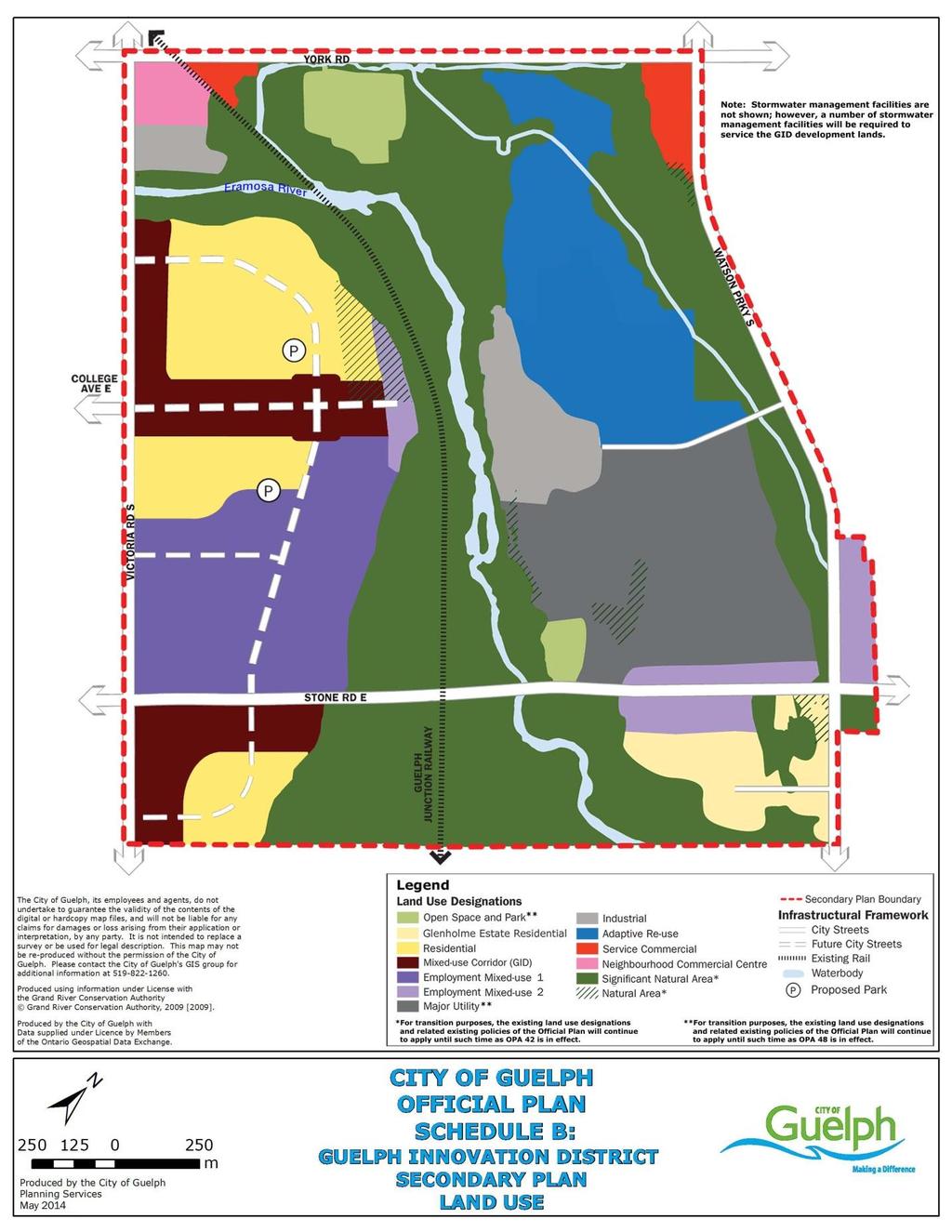
52 52
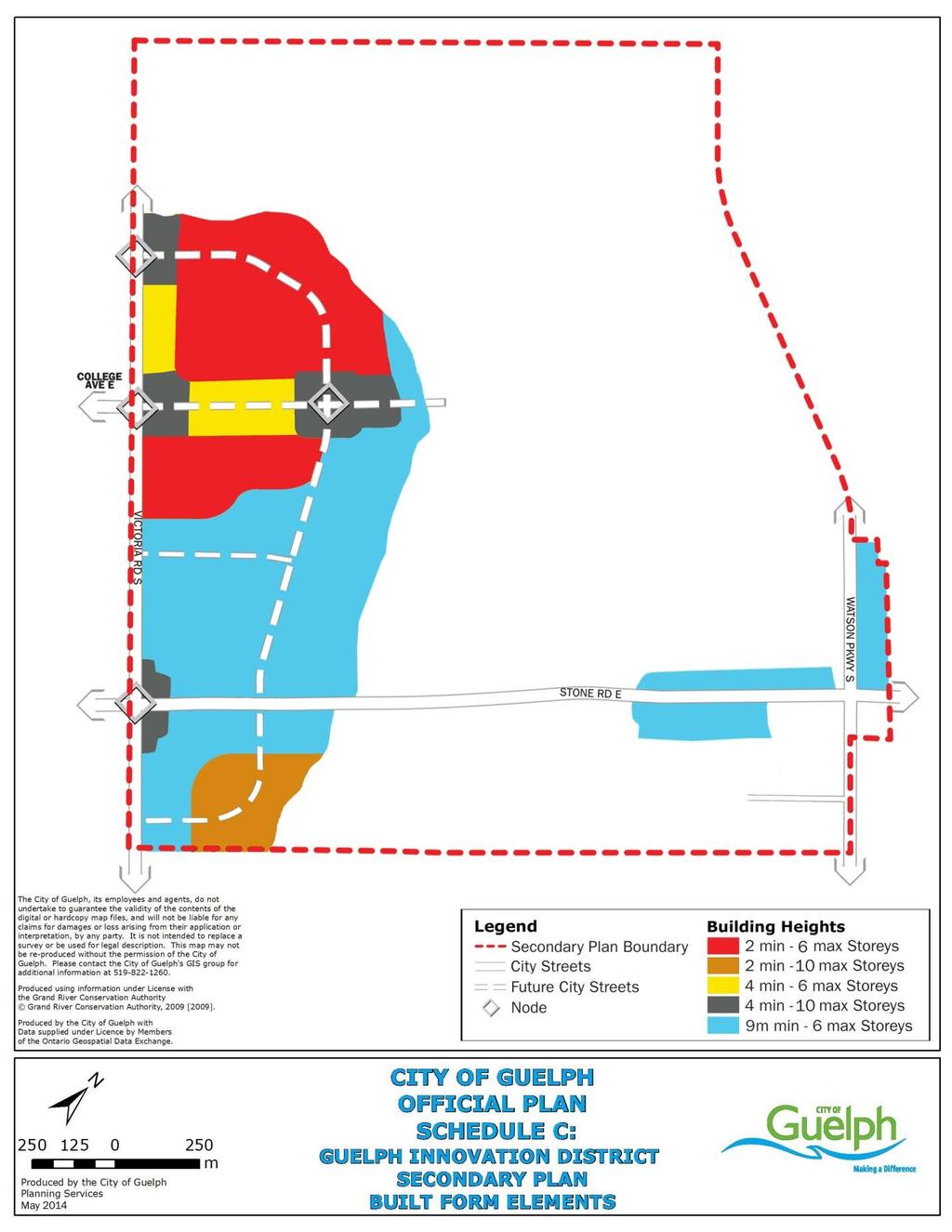
53 53
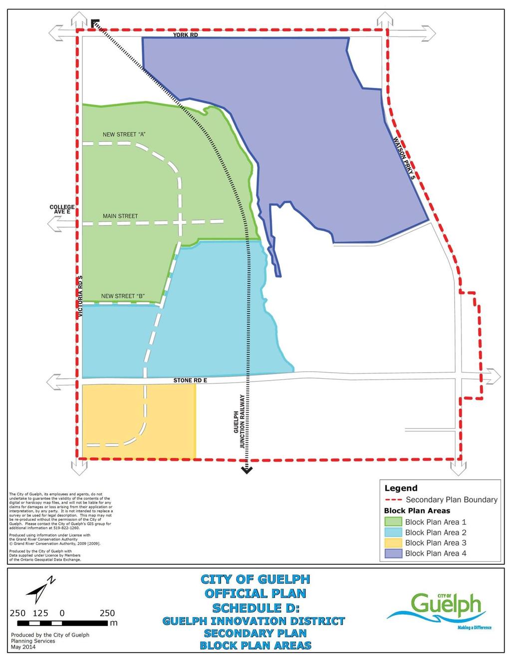
54 54
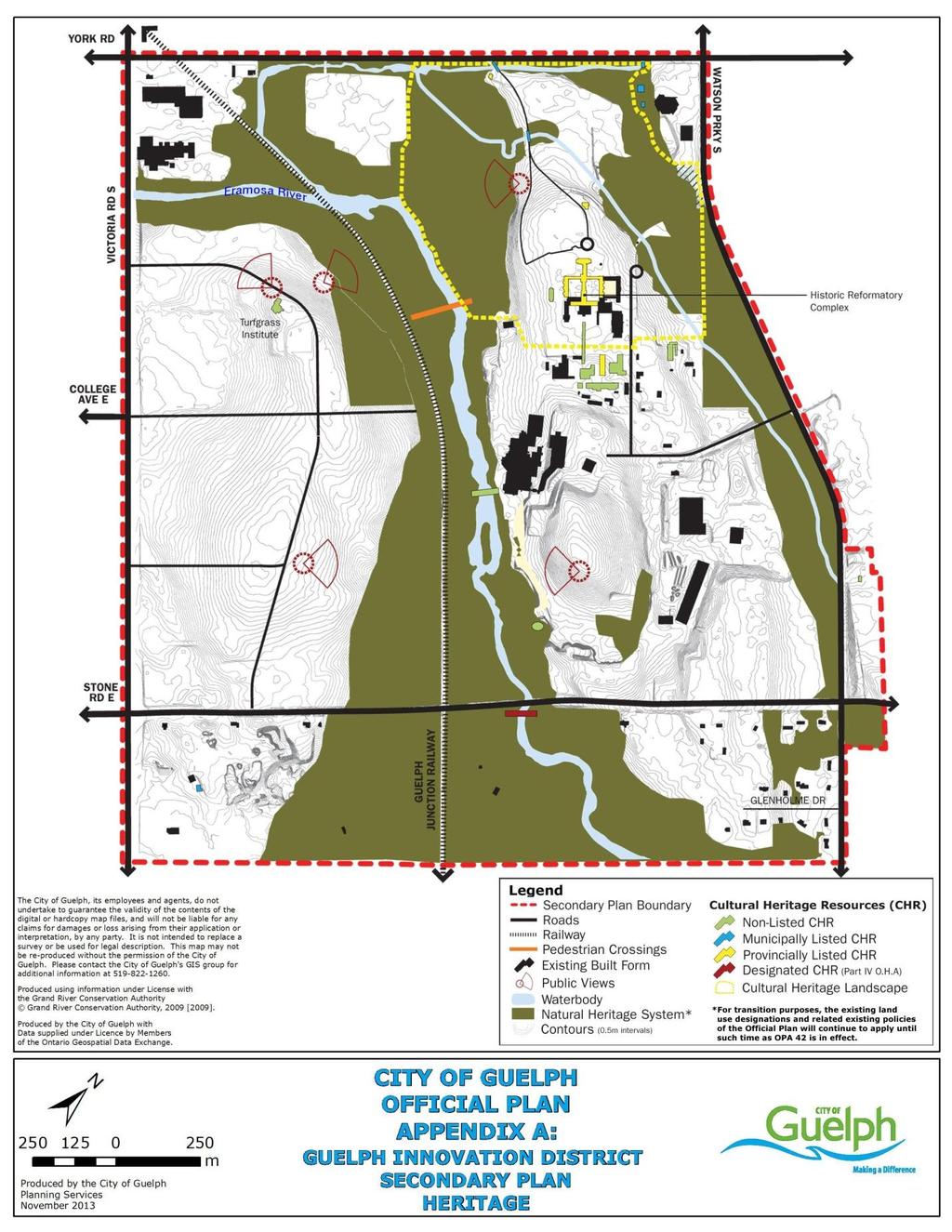
55 55
56 ITEM 4: The purpose of ITEM 4 is to reflect and refer to the completion of the Guelph Innovation District Secondary Plan. Official Plan Schedule 1, entitled Land Use Plan is hereby amended by greying out the lands subject to the Guelph Innovation District Secondary Plan as depicted on the attached Schedule 1: 56
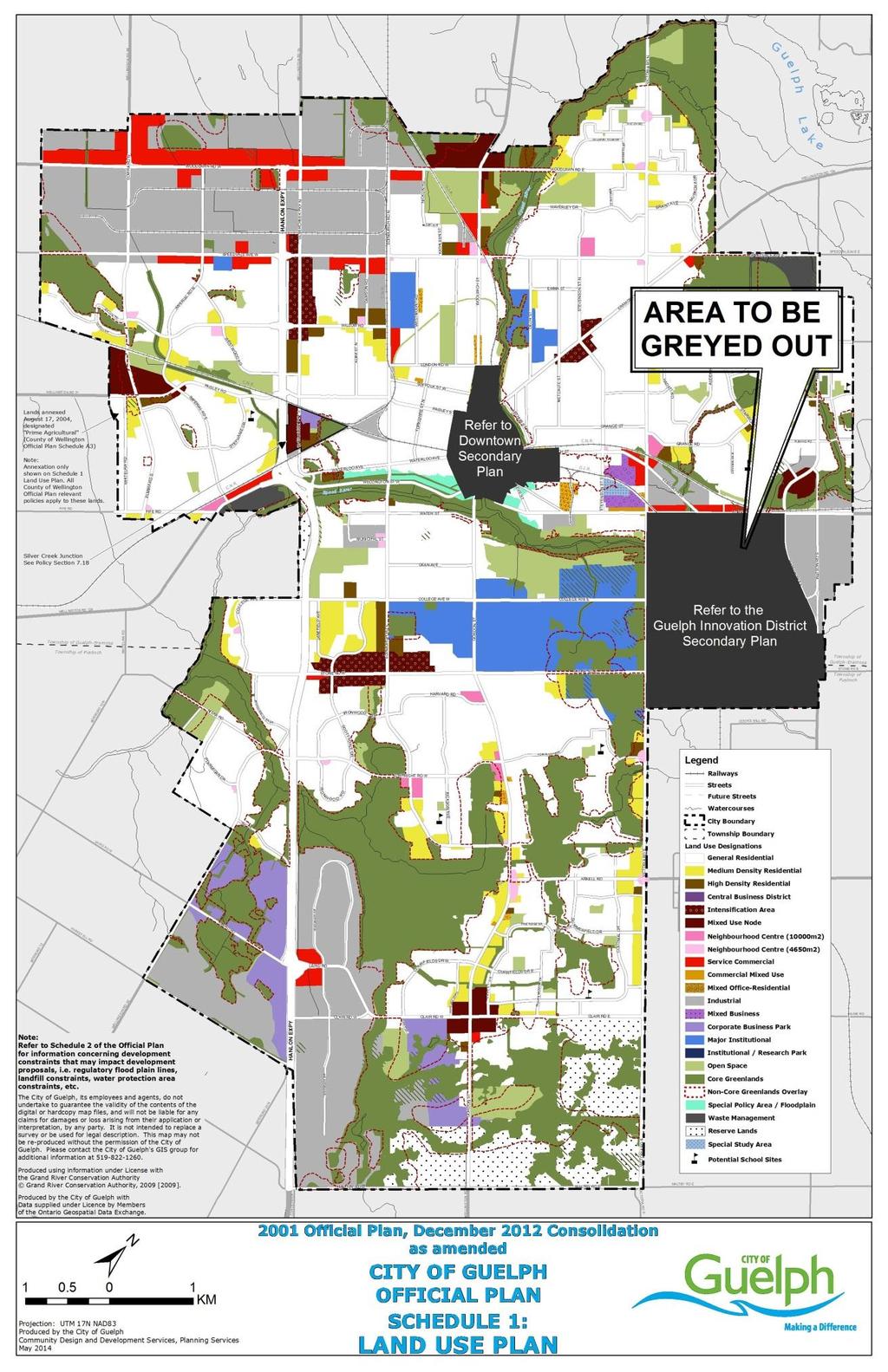
57 57
58 ITEM 5: The purpose of ITEM 5 is to add the boundary of the Guelph Innovation District Secondary Plan and revise the South Guelph Secondary Plan boundary to exclude the Guelph Innovation District Secondary Plan Area on Schedule 1A (Secondary Plans & Water Features). Official Plan Schedule 1A, entitled Secondary Plans & Water Features is hereby amended by adding the lands subject to the Guelph Innovation District Secondary Plan as depicted on the following mapping: 58
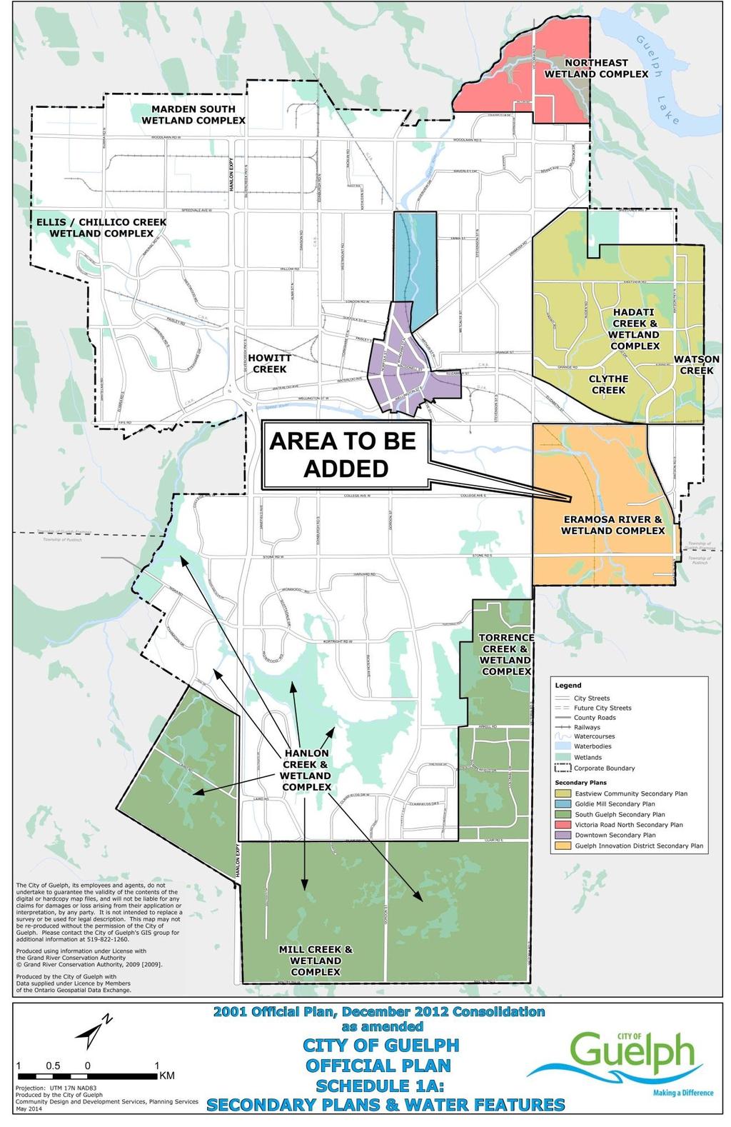
59 59
60 ITEM 6: The purpose of ITEM 6 is to reflect and refer to the completion of the Guelph Innovation District Secondary Plan on Schedule 2 (Development Constraints). Official Plan Schedule 2, entitled Development Constraints is hereby amended by greying out the lands subject to the Guelph Innovation District Secondary Plan as depicted on the following mapping: 60
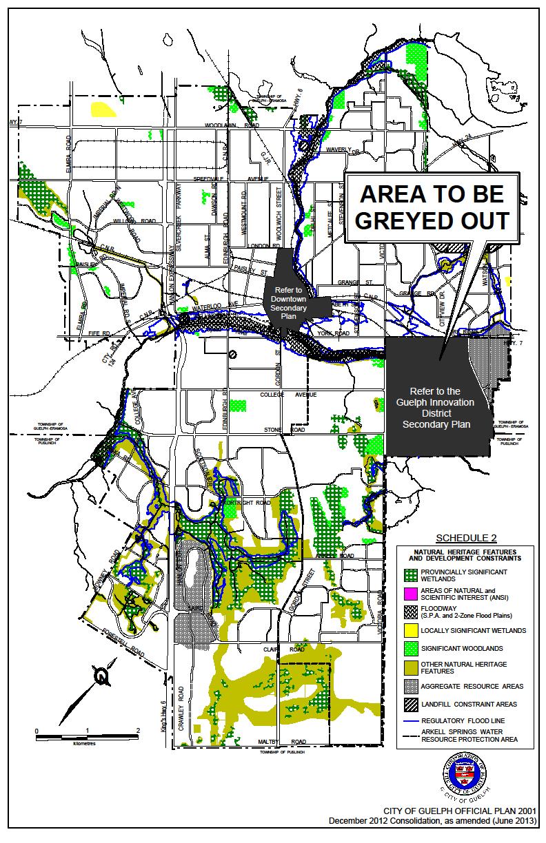
61 61
62 ITEM 7: The purpose of ITEM 7 is to remove the lands south of Stone Road East, east of Victoria Road from the Proposed Secondary Plan Phasing, including the 2.b text as it relates to those lands on Schedule 4B (South Guelph Secondary Plan Area Phasing of Development) to reflect the Guelph Innovation District Secondary Plan completion. Official Plan Schedule 4B, entitled South Guelph Secondary Plan Area Phasing of Development is hereby amended by removing the lands, from the Proposed Secondary Plan Phasing, including the 2.b text as it relates to those lands, subject to the Guelph Innovation District Secondary Plan as depicted on the following mapping: 62
63 63
64 ITEM 8: The purpose of ITEM 8 is to revise Schedule 9A (Existing Road Network) to reflect completion of the Guelph Innovation District Secondary Plan. Official Plan Schedule 9A, entitled Existing Road Network is hereby amended by hatching out the lands subject to the Guelph Innovation District Secondary Plan as depicted on the following mapping: 64
65 65
66 Item 9: The purpose of ITEM 9 is to revise Schedule 9B (Recommended Road Plan for Further Study and Environmental Assessment) to reflect completion of the Guelph Innovation District Secondary Plan. Official Plan Schedule 9B, entitled Recommended Road Plan for Further Study and Environmental Assessment is hereby amended by hatching out the lands subject to the Guelph Innovation District Secondary Plan as depicted on the following mapping: 66
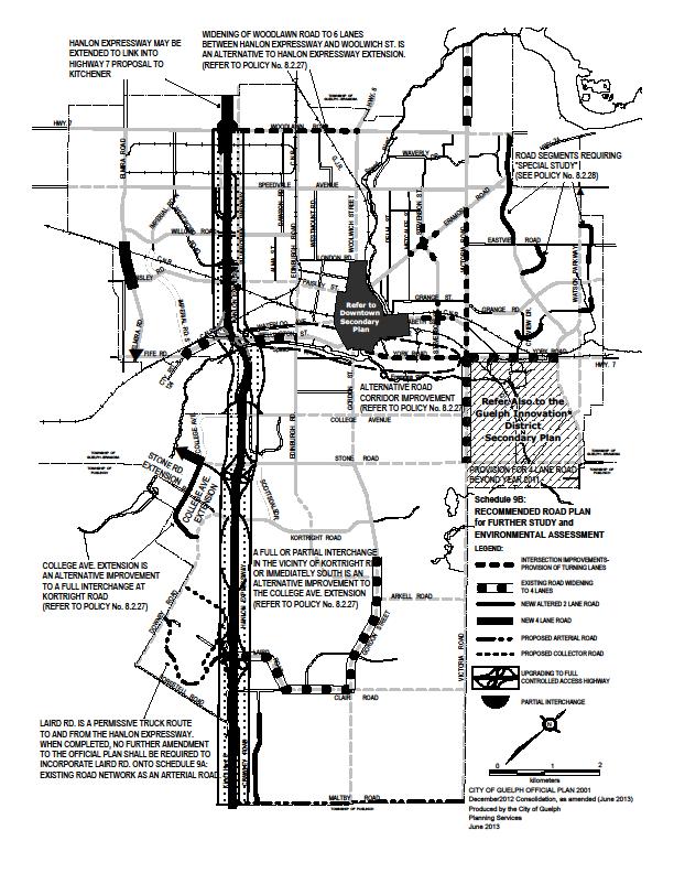
67 67
68 Item 10: The purpose of ITEM 10 is to revise Schedule 9C (Bicycle Network Plan) to reflect completion of the Guelph Innovation District Secondary Plan. Official Plan Schedule 9C, entitled Bicycle Network Plan is hereby amended by hatching out the lands subject to the Guelph Innovation District Secondary Plan as depicted on the following mapping: 68
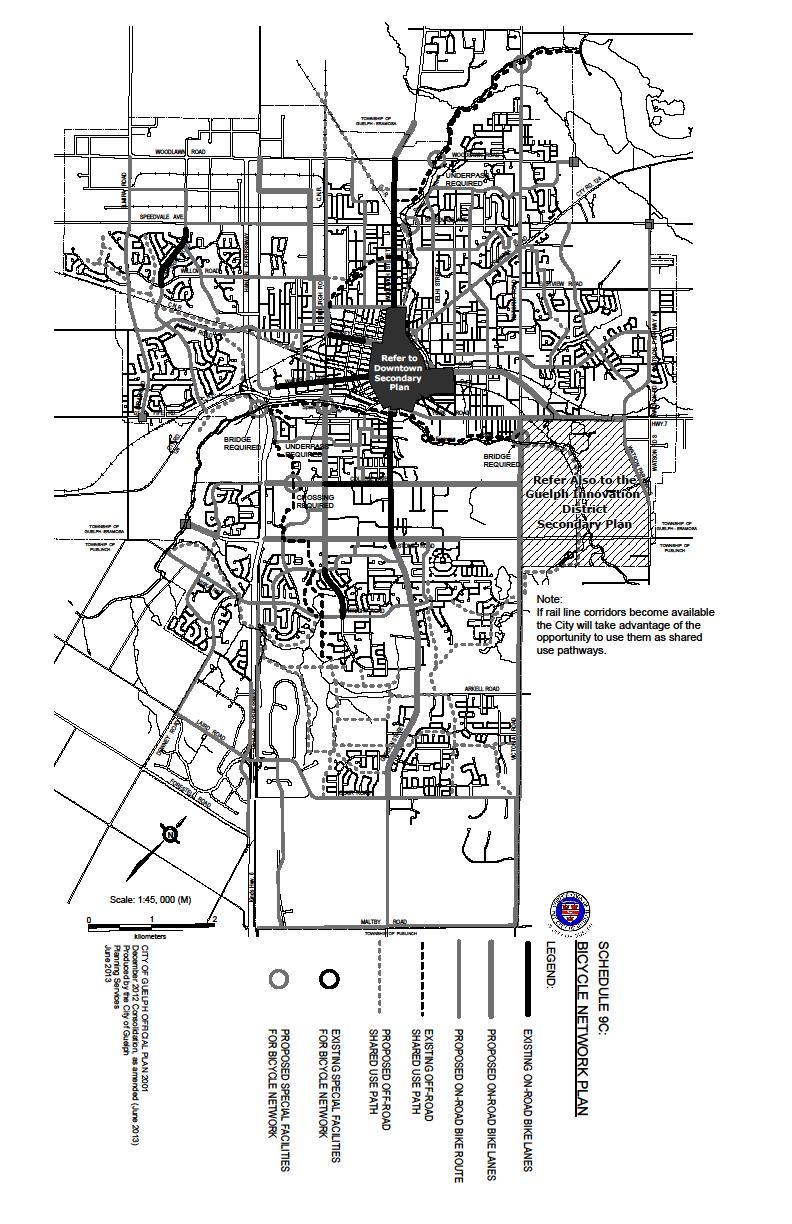
69 69
AMENDMENT NUMBER 48 TO THE OFFICIAL PLAN FOR THE CORPORATION OF THE CITY OF GUELPH: ENVISION GUELPH: OFFICIAL PLAN UPDATE PHASE 3
 AMENDMENT NUMBER 48 TO THE OFFICIAL PLAN FOR THE CORPORATION OF THE CITY OF GUELPH: ENVISION GUELPH: OFFICIAL PLAN UPDATE PHASE 3 PART A - THE PREAMBLE INDEX The Preamble provides an explanation of the
1 Introduction. Chapter. In this chapter:
 Chapter 1 Introduction In this chapter: 1.1 A Snapshot of the Region 1.2 Towards a Sustainable Region 1.3 The Provincial Context 1.4 Purpose and Organization The Regional Municipality of York Official
Official Plan Review: Draft Built Form Policies
 PG.30.1 REPORT FOR ACTION Official Plan Review: Draft Built Form Policies Date: May 15, 2018 To: Planning and Growth Management Committee From: Chief Planner and Executive Director, City Planning Division
Downtown Streetscape Manual & Built Form Standards
 City of Guelph Downtown Streetscape Manual & Built Form Standards July 2014 Prepared by Brook McIlroy Inc. in association with Unterman McPhail Associates and McCormick Rankin Inc. City of Guelph Downtown
Edward R. Sajecki Commissioner of Planning and Building
 Corporate Report Clerk s Files Originator s Files CD.03.POR DATE: TO: FROM: SUBJECT: Chair and Members of Planning and Development Committee Meeting Date: February 27, 2012 Edward R. Sajecki Commissioner
COMMUNITY SUSTAINABILITY AND ENVIRONMENTAL MASTER PLAN IMPLEMENTATION UPDATE
 Attachment 1 COMMUNITY SUSTAINABILITY AND ENVIRONMENTAL MASTER PLAN IMPLEMENTATION UPDATE Priorities and Key Initiatives Committee May 2013 Page E-1 How we grow Goal 2: To ensure sustainable development
SUBJECT: Waterfront Hotel Planning Study Update TO: Planning and Development Committee FROM: Department of City Building. Recommendation: Purpose:
 Page 1 of Report PB-23-18 SUBJECT: Waterfront Hotel Planning Study Update TO: Planning and Development Committee FROM: Department of City Building Report Number: PB-23-18 Wards Affected: 2 File Numbers:
Report to: Development Services Committee Report Date: April 24, 2017
 SUBJECT: Cornell Rouge National Urban Park Gateway - Report on Design Charrette and Next Steps PREPARED BY: Lilli Duoba, MES, MCIP, RPP, Manager, Natural Heritage (ext. 7925) REVIEWED BY: Marg Wouters,
THE CORPORATION OF THE TOWN OF OAKVILLE BY-LAW NUMBER
 THE CORPORATION OF THE TOWN OF OAKVILLE BY-LAW NUMBER 2017-120 A by-law to adopt an amendment to the Livable Oakville Plan, Official Plan Amendment Number 20 (Downtown Oakville Growth Area) WHEREAS the
6 Growth Management Challenges and Opportunities
 6 Growth Management Challenges and Opportunities The Town has established a goal of attaining a 50% participation rate with respect to employment opportunities versus residential population. The Town s
Official Plan Review
 Official Plan Review Summary Report - The Built Environment August 2014 Part 1: Introduction Planning for a healthy, prosperous and sustainable community is an important goal for our municipality. From
Urban Design Manual PLANNING AROUND RAPID TRANSIT STATIONS (PARTS) Introduction. Station Study Areas
 Introduction. Station Study Areas") 111111 PLANNING AROUND RAPID TRANSIT STATIONS (PARTS) Introduction The ION rapid transit system will link Waterloo, Kitchener and Cambridge through a central transit corridor (CTC). There are a number
111111 PLANNING AROUND RAPID TRANSIT STATIONS (PARTS) Introduction The ION rapid transit system will link Waterloo, Kitchener and Cambridge through a central transit corridor (CTC). There are a number
St. Lawrence Neighbourhood Focused Area - Official Plan Amendment Status Report
 STAFF REPORT ACTION REQUIRED St. Lawrence Neighbourhood Focused Area - Official Plan Amendment Status Report Date: May 21, 2015 To: From: Wards: Reference Number: Toronto and East York Community Council
The West Vaughan Employment Area Secondary Plan Policies
 Part 2: The West Vaughan Employment Area Secondary Plan Policies 2.1 General Policies It is the policy of Council: 2.1.1. That the West Vaughan Employment Area (the WVEA), identified on Schedule 1, will
MAYFIELD WEST SECONDARY PLAN PHASE 2
 MAYFIELD WEST SECONDARY PLAN PHASE 2 Public Open House #3 February 25, 2010 Draft Preferred Land Use Scenario TOWN OF CALEDON PLANNING & DEVELOPMENT DEPARTMENT Open House Agenda TOWN OF CALEDON 1. Welcome
SUBJECT: Proposed Downtown Mobility Hub Precinct Plan and Proposed Official Plan Policies
 Page 1 of Report PB-81-17 SUBJECT: Proposed Downtown Mobility Hub Precinct Plan and Proposed Official Plan Policies TO: FROM: Committee of the Whole Planning and Building Department Report Number: PB-81-17
Complete Neighbourhood Guidelines Review Tool
 Complete Neighbourhood Guidelines Review Tool Prepared By: City of Regina Planning Department October 2014 Page 1 of 14 Community Development Review Checklist for Secondary Plans and Concept Plans The
1.0 Purpose of a Secondary Plan for the Masonville Transit Village
 Report to Planning and Environment Committee To: Chair and Members Planning & Environment Committee From: John M. Fleming Managing Director, Planning and City Planner Subject: Masonville Transit Village
Town of Cobourg Heritage Master Plan. Statutory Public Meeting
 Town of Cobourg Heritage Master Plan Statutory Public Meeting April 25 th 2016 Presentation Overview 1. Introduction 2. Project background and schedule overview 3. Review of strategic direction content
THE GARDEN CITY PLAN. City of St. Catharines Official Plan. City of St. Catharines
 THE GARDEN CITY PLAN City of St. Catharines Official Plan City of St. Catharines August 2010 APPROVAL INFORMATION This Official Plan of the City of St. Catharines Planning Area, known as the Garden City
Welcome to the Oakridge Centre Open House
 Welcome to the Oakridge Centre Open House Why is the City hosting this event? This open house is to inform you of a rezoning application submitted to the City of Vancouver to amend the existing CD-1 (Comprehensive
PLAN ELEMENTS WORKSHOP. April 5, 2016
 PLAN ELEMENTS WORKSHOP April 5, 2016 needs more housing. But there is no one-size fits-all solution. Every neighborhood has its own character. In some places, density is not only appropriate it is badly
MAYFIELD WEST SECONDARY PLAN PHASE 2
 MAYFIELD WEST SECONDARY PLAN PHASE 2 Council Information Workshop February 16, 2010 Draft Preferred Land Use Plan TOWN OF CALEDON PLANNING & DEVELOPMENT DEPARTMENT Workshop Agenda TOWN OF CALEDON 1. Welcome
PORT WHITBY COMMUNITY
 PORT WHITBY COMMUNITY SECONDARY PLAN UPDATE COMMUNITY IMPROVEMENT PLAN URBAN DESIGN GUIDELINES September 2015 DRAFT PROPOSED AMENDMENT NUMBER # to the Whitby Official Plan PURPOSE: The intent of this Amendment
FORMER CANADIAN FORCES BASE (CFB) ROCKCLIFFE SECONDARY PLAN. Official Plan Amendment XX to the Official Plan for the City of Ottawa
 ROCKCLIFFE SECONDARY PLAN. Official Plan Amendment XX to the Official Plan for the City of Ottawa") FORMER CANADIAN FORCES BASE (CFB) ROCKCLIFFE SECONDARY PLAN Official Plan Amendment XX to the Official Plan for the City of Ottawa 1 INDEX THE STATEMENT OF COMPONENTS PART A THE PREAMBLE PAGE Purpose...
FORMER CANADIAN FORCES BASE (CFB) ROCKCLIFFE SECONDARY PLAN Official Plan Amendment XX to the Official Plan for the City of Ottawa 1 INDEX THE STATEMENT OF COMPONENTS PART A THE PREAMBLE PAGE Purpose...
Town Center (part of the Comprehensive Plan)
") Town Center (part of the Comprehensive Plan) Mercer Island Town Center Looking North (2014) In 1994, a year-long process culminated in a set of design guidelines and code requirements for the Town Center
Town Center (part of the Comprehensive Plan) Mercer Island Town Center Looking North (2014) In 1994, a year-long process culminated in a set of design guidelines and code requirements for the Town Center
4- PA - LD - LIVELY DOWNTOWN. LD - Background
 4- PA - LD - LIVELY DOWNTOWN LD - Background The downtown has been the service centre for the community since the city s inception and the area continues to supply people with their personal services,
1.0 PLANNING MARKHAM S FUTURE CONTENTS
 1-1 Planning Markham s Future 1.0 PLANNING MARKHAM S FUTURE CONTENTS 1.1 THE PURPOSE OF THE OFFICIAL PLAN 1.2 THE MARKHAM CONTEXT 1.3 THE REGULATORY CONTEXT 1.3.1 Province of Ontario 1.3.2 York Region
South of Eastern Strategic Direction Status Update
 STAFF REPORT ACTION REQUIRED South of Eastern Strategic Direction Status Update Date: July 10, 2014 To: From: Planning and Growth Management Committee Chief Planner and Executive Director, City Planning
9 CITY OF VAUGHAN OFFICIAL PLAN AMENDMENT NO BOCA EAST INVESTMENTS LIMITED
 9 CITY OF VAUGHAN OFFICIAL PLAN AMENDMENT NO. 631 - BOCA EAST INVESTMENTS LIMITED The Planning and Economic Development Committee recommends the adoption of the recommendations contained in the following
Welcome. Walk Around. Talk to Us. Write Down Your Comments
 Welcome This is an information meeting introducing the applications for proposed redevelopment of the Yorkdale Shopping Centre site at 3401 Dufferin Street and 1 Yorkdale Road over the next 20+ years,
University of Saskatchewan CAMPUS MASTER PLAN. Senate Meeting Preliminary Presentation. April 21, 2018 DIALOG ECS DA WATT
 University of Saskatchewan CAMPUS MASTER PLAN Senate Meeting Preliminary Presentation April 21, 2018 DIALOG ECS DA WATT project process presentation agenda Stakeholder Engagement Project Control phase1
4 Sustainability and Growth Management
 4 Sustainability and Growth Management Introduction Traditionally, has assumed growth and development with limited consideration for the long-term negative social, environmental or economic impacts on
Municipal Development Plan 2013
 UNIQUELY STONY PLAIN: Municipal Development Plan 2013 Quick Reference Guide What is a Municipal Development Plan (MDP)? The Town s highest-level planning document Sets the long-term vision and key themes
Chair and Members of the Planning, Public Works and Transportation Committee. Tara Buonpensiero, Senior Planner Policy, MCIP, RPP
 REPORT TO: REPORT FROM: Chair and Members of the Planning, Public Works and Transportation Committee Tara Buonpensiero, Senior Planner Policy, MCIP, RPP DATE: April 9, 2018 REPORT NO.: RE: PLS-2018-0027
Mark-up of the effect of the proposed Bronte Village Growth Area OPA No.18 on the text of section 24, Bronte Village, of the Livable Oakville Plan
 Mark-up of the effect of the proposed Bronte Village Growth Area OPA No.18 on the text of section 24, Bronte Village, of the Livable Oakville Plan Notes: This document is provided for information purposes
Public Open House. Overview of the Downtown Plan Official Plan Amendment April 23, 2018
 Public Open House Overview of the Downtown Plan Official Plan Amendment April 23, 2018 1 A 25-Year Plan for Downtown To ensure growth contributes positively to Toronto s Downtown as a great place to live,
Plan Framework Report. Attachment A
 Plan Framework Report Attachment A Uptown-Douglas Corridor Plan - Plan Framework Report Contents Introduction... 1 Planning Process... 3 Project Objectives... 4 Vision... 5 Community Values... 6 Structural
Table 8-4: Road Classification Local Roads, second table, of Chapter 8 Create a Multi-Modal City, be amended by adding the following:
 1 Port Street East Official Plan Amendment APPENDIX 3 Amendments to Mississauga Official Plan Table 8-4: Road Classification Local Roads, second table, of Chapter 8 Create a Multi-Modal City, be amended
hermitage town center
 hermitage town center A Community Vision prepared by Strada for The City of Hermitage and The Mercer County Regional Planning Commission January 2007 table of contents introduction 3 design principles
SUBJECT: GO Station Mobility Hubs Preferred Concepts: Aldershot GO, Burlington GO and Appleby GO. Planning and Development Committee - Public Meeting
 Page 1 of Report PB-76-17 SUBJECT: GO Station Mobility Hubs Preferred Concepts: Aldershot GO, Burlington GO and Appleby GO TO: FROM: Planning and Development Committee - Public Meeting Planning and Building
John M. Fleming Managing Director, Planning and City Planner. Old East Village Dundas Street Corridor Secondary Plan Draft Terms of Reference
 Report to Planning and Environment Committee To: From: Subject: Chair and Members Planning & Environment Committee John M. Fleming Managing Director, Planning and City Planner Old East Village Dundas Street
Infrastructure, Development and Enterprise Services. Natural Heritage Action Plan (NHAP) Project Initiation
 Project Initiation") Staff Report To Service Area Committee of the Whole Infrastructure, Development and Enterprise Services Date Monday, March 6, 2017 Subject Natural Heritage Action Plan (NHAP) Project Initiation Report
Staff Report To Service Area Committee of the Whole Infrastructure, Development and Enterprise Services Date Monday, March 6, 2017 Subject Natural Heritage Action Plan (NHAP) Project Initiation Report
2.0 Strategic Context 4
 2.0 Strategic Context 4 2.1 The Area Action Plan is a non-statutory plan, which forms a corporate policy document, expressing particular issues and areas of concern while also providing a vision for the
ARLINGTON COUNTY, VIRGINIA
 ARLINGTON COUNTY, VIRGINIA County Board Agenda Item Meeting October 15, 2005 DATE: September 28, 2005 SUBJECT: Request to Advertise the adoption of the 2005 Clarendon Sector Plan C. M. RECOMMENDATION:
The protection of the agricultural resources of the Province;
 PART II INTRODUCTION An Official Plan is a policy document, which is intended to serve as the basis for making land use decisions and managing change in any municipality in Ontario. According to the Planning
CONTENTS 2.0 A FRAMEWORK FOR SUSTAINABLE GROWTH 2.1 MANAGING SUSTAINABLE GROWTH THE VISION TO GOALS AND OBJECTIVES 2.3 MARKHAM STRUCTURE
 2 A Framework for Sustainable Growth 2.0 A FRAMEWORK FOR SUSTAINABLE GROWTH CONTENTS 2.1 MANAGING SUSTAINABLE GROWTH THE VISION TO 2031 2.2 GOALS AND OBJECTIVES 2.2.1 Protecting the Natural Environment
SCARBOROUGH SUBWAY EXTENSION. Scarborough Subway Extension. Final Terms of Reference
 Scarborough Subway Extension Final Terms of Reference 1 1.0 Introduction and Background 1.1 Introduction Toronto City Council recently confirmed support for an extension of the Bloor-Danforth Subway from
WELCOME and introduction
 1 WELCOME and introduction Mobility Hub Locations within Burlington STUDY OVERVIEW STUDY OBJECTIVES The City of Burlington is developing four Area Specific Plans, one for each of Burlington s Mobility
2040 LUP is a part of the Comprehensive Plan and carries the same legal authority. Economic Challenges
 1.1. Guiding Anchorage s Growth Where will new residents settle over the next two decades? Where will people work, shop, and play? Will there be enough room to grow? How will Anchorage look? Will growth
2.0 A FRAMEWORK FOR SUSTAINABLE GROWTH CONTENTS
 2-2 A Framework for Sustainable Growth 2.0 A FRAMEWORK FOR SUSTAINABLE GROWTH CONTENTS 2.1 MANAGING SUSTAINABLE GROWTH THE VISION TO 2031 2.2 GOALS AND OBJECTIVES 2.2.1 Protecting the Natural Environment
THE CORPORATION OF THE TOWN OF OAKVILLE BY-LAW NUMBER
 THE CORPORATION OF THE TOWN OF OAKVILLE BY-LAW NUMBER 20012-08530 A by-law to adopt an amendment to the Official Plan of the Oakville Planning Area (Official Plan Amendment 198) Land North of Dundas Street.
THE TOWN OF WASAGA BEACH
 THE TOWN OF WASAGA BEACH Downtown Development Master Plan Committee of the Whole Presentation January 26 th 2017 Uses within this designation should reflect a dependence on tourism as opposed to the permanent
Sustainable Growth. Sustainable Growth
 2 Sustainable Growth Sustainable Growth SUSTAINABLE GROWTH 2.1 COMMUNITY VISION... 2-5 2.2 THE CITY SYSTEM... 2-7 2.2.1 AREAS... 2-7 2.2.2 CITY-WIDE SYSTEMS... 2-8 2.2.3 PROVINCIAL PLAN BOUNDARIES AND
DOWNTOWN GEORGETOWN PLANNING STUDY
 DOWNTOWN GEORGETOWN PLANNING STUDY Community Workshop #3 Thursday, May 4, 08 The Planning Partnership OVERVIEW OF STUDY, PROCESS & MILESTONES We are here PURPOSE OF THE STUDY To develop a clear vision
Report to: Development Services Committee Report Date: September 11, 2017
 ~RKHAM Report to: Development Services Committee Report Date: September 11, 2017 SUBJECT: PREPARED BY: Conceptual Master Plan for the Future Urban Area - Community Structure Plan and Key Policy Direction
DOMINION BOULEVARD CORRIDOR STUDY AND ECONOMIC DEVELOPMENT STRATEGIC PLAN A MODEL FOR CHESAPEAKE S FUTURE
 DOMINION BOULEVARD CORRIDOR STUDY AND ECONOMIC DEVELOPMENT STRATEGIC PLAN A MODEL FOR CHESAPEAKE S FUTURE Overview I. Draft Plan Process II. Draft Plan Overview a. Market Analysis b. Master Land Use Plan
ONTARIO MUNICIPAL BOARD
 PL 120483 ONTARIO MUNICIPAL BOARD Applicant/Appellant: 2124123 Ontario Limited Subject: OPA, Rezoning and Draft Plan of Subdivision Municipal Address: 3940 Highway 7 East Municipality: City of Markham
MOUNT PLEASANT SECONDARY PLAN & VILLAGE BLOCK PLAN. Wednesday, March 5, 2008 Informal Public Open House
 MOUNT PLEASANT SECONDARY PLAN & VILLAGE BLOCK PLAN Wednesday, March 5, 2008 Informal Public Open House 1. Welcome & Introductions 2. Highlights of Provincial Growth Plan 3. Overview and Status Update -
DRAFT Northeast Quadrant of Kipling Avenue and Highway 7 DRAFT AUGUST 29, Goals Land Use. The goals of this Plan are to:
 AUGUST 29, 2017 12.15 Northeast Quadrant of Kipling Avenue and Highway 7 12.15.1 Goals 12.15.2 Land Use The goals of this Plan are to: 12.15.2.1 General Provisions: a) Ensure the development of a compact
Parks Master Plan Implementation: Phase I Waterfront Use and Design REPORT #: September 7, 2016 File #
 0 'O DI Lan-171-14 1 - THE CORPORATION OF THE TOWN OF COBOURG..,. STAFF REPORT TO: FROM: Mayor and Members of Council Dean A. Hustwick, Director of Recreation and Culture DATE OF MEETING: Committee of
and Richmond Street West - Official Plan Amendment Application - Preliminary Report
 STAFF REPORT ACTION REQUIRED 822-838 and 860-862 Richmond Street West - Official Plan Amendment Application - Preliminary Report Date: August 14, 2017 To: From: Wards: Reference Number: Toronto and East
PART 1. Background to the Study. Avenue Study. The Danforth
 The Danforth 1.1/ Study Purpose & Key Municipal Goals 1.2/ The Local Advisory Committee 1.3/ The Project Team 1.4/ Study Process/Summary of Method 1.5/ Summary of Consultation 1.1 Study Purpose and Key
Commercial, Retail and Tourism Executive Summary December 2018
 Town of Wasaga Beach Official Plan Review, Retail and Executive Summary December 2018 1 An Official Plan directs where and how to grow The preparation of a new Official Plan for Wasaga Beach is an opportunity
Workshop 3. City of Burlington Waterfront Hotel Planning Study. September 14, The Planning Partnership
 Workshop 3 City of Burlington Waterfront Hotel Planning Study September 14, 2017 The Planning Partnership The Waterfront Hotel Planning Study 01 The Brant & Lakeshore Planning Study will establish a Strategic
38 Queen s University Campus Master Plan Part 1
 38 Queen s University Campus Master Plan Part 1 46 The Campus at the City Scale Chapter 4 The Campus at the City Scale 39 Queen s is an urban University centrally located in Kingston. Decisions made by
3 TOWN OF WHITCHURCH-STOUFFVILLE OFFICIAL PLAN AMENDMENT NOS. 116 & 117
 3 TOWN OF WHITCHURCH-STOUFFVILLE OFFICIAL PLAN AMENDMENT NOS. 116 & 117 The Planning and Economic Development Committee recommends the adoption of the recommendations contained in the following report,
1 Welcome! UBC Okanagan Master Plan Update - Open House
 1 Welcome! UBC Okanagan Master Plan Update - Open House UBC is updating the Master Plan for the Okanagan Campus. The purpose of today s Open House is to: Present the draft 2015 Master Plan Answer any questions
Town of Oakville Streetscape Strategy
 Town of Oakville Streetscape Strategy Endorsed by PDC on February 10, 2014 (PD-011-14) Town of Oakville Streetscape Strategy [endorsed by PDC February 10, 2014] 0 Town of Oakville Streetscape Strategy
Summary of Changes for the Comprehensive Draft Proposed Official Plan Amendment
 Summary of Changes for the Comprehensive Draft Proposed Official Plan Amendment Note: Due to the broad scope of the Official Plan Review, this list is not exhaustive of the extent of changes in the comprehensive
Downtown Whitby Action Plan
 Downtown Whitby Action Plan Final Report October 2016 Table of Contents Introduction 1 Public Consultation 2 Walkability 3 Downtown Whitby Walkability Map 4 Vision 5 Goal & Objectives 6 Objective 1 7 Objective
Streets for People, Place-Making and Prosperity. #TOcompletestreets
 COMPLETE STREETS FOR TORONTO Streets for People, Place-Making and Prosperity COMPLETE STREETS: A NEW APPROACH A Complete Streets design approach considers the needs of all users people who walk, bicycle,
Westwind Developments Ltd. PIONEER LANDS AREA STRUCTURE PLAN - PROPOSED AMENDMENT
 FEBRUARY 2013 TABLE OF CONTENTS 1.0 BACKGROUND... 1 1.1 Amendment... 1 2.0 LOCATION & CONTEXT... 2 2.1 Land Ownership... 2 3.0 POLICY CONTEXT... 3 3.1 Municipal Development Plan... 3 3.2 Capital Region
CONTENTS 6.1 URBAN DESIGN
 6-2 Urban Design and Sustainable Development 6.0 URBAN DESIGN AND SUSTAINABLE DEVELOPMENT CONTENTS 6.1 URBAN DESIGN 6.1.1 General Policies 6.1.2 The Public Realm 6.1.3 Streets and Blocks 6.1.4 Streetscapes
ROAD CLOSURE AND LAND USE AMENDMENT SILVER SPRINGS (WARD 1) NORTHEAST OF NOSEHILL DRIVE NW AND SILVER SPRINGS ROAD NW BYLAWS 2C2018 AND 29D2018
 NORTHEAST OF NOSEHILL DRIVE NW AND SILVER SPRINGS ROAD NW BYLAWS 2C2018 AND 29D2018") Page 1 of 19 EXECUTIVE SUMMARY This application proposes redesignating two parcels in the community of Silver Springs from Special Purpose Future Urban Development (S-FUD) District and undesignated road
Page 1 of 19 EXECUTIVE SUMMARY This application proposes redesignating two parcels in the community of Silver Springs from Special Purpose Future Urban Development (S-FUD) District and undesignated road
2.0 A FRAMEWORK FOR SUSTAINABLE GROWTH CONTENTS
 2-2 A Framework for Sustainable Growth 2.0 A FRAMEWORK FOR SUSTAINABLE GROWTH CONTENTS 2.1 MANAGING SUSTAINABLE GROWTH THE VISION TO 2031 2.2 GOALS AND OBJECTIVES 2.2.1 Protecting the Natural Environment
section 3: Vision, Values and Goals
 Vision, Values and Goals 3 2041 Vision: Victoria is an urban sustainability leader inspiring innovation, pride and progress towards greater ecological integrity, livability, economic vitality, and community
Former Rockcliffe Airbase Community Design Plan Guiding Design Vision and Principles December 4, 2013
 APPENDIX 5 - Guiding Design Vision and Principles Former Rockcliffe Airbase Community Design Plan Guiding Design Vision and Principles December 4, 2013 Vision Statement The redevelopment of the former
12 AMENDMENT NO. 149, TOWN OF MARKHAM HIGHWAY 404 NORTH SECONDARY PLAN
 12 AMENDMENT NO. 149, TOWN OF MARKHAM HIGHWAY 404 NORTH SECONDARY PLAN The Planning and Economic Development Committee recommends the adoption of the recommendation contained in the following report August
CONTENTS 8.0 LAND USE 8.1 GENERAL LAND USE 8.2 RESIDENTIAL 8.3 MIXED USE 8.4 COMMERCIAL 8.5 EMPLOYMENT LANDS
 8-2 Land Use 8.0 LAND USE CONTENTS 8.1 GENERAL LAND USE 8.1.1 Uses provided for in all Land Use Designations 8.1.2 Uses prohibited in Hazardous Lands, Hazardous Sites and Special Policy Areas 8.1.3 Uses
SECTION E. Realizing the Plan
 SECTION E Realizing the Plan 60 DESIGN REGINA - OFFICIAL COMMUNITY PLAN SECTION E Realizing the Plan Design Regina has been an ambitious plan-making exercise, with a high level of community, stakeholder,
CITY OF VAUGHAN EXTRACT FROM COUNCIL MEETING MINUTES OF NOVEMBER 15, 2016
 Item 11, Report No. 38, of the Committee of the Whole, which was adopted without amendment by the Council of the City of Vaughan on November 15, 2016. Regional Councillor Di Biase declared an interest
SECTION ONE: INTRODUCTION. introduction
 introduction 1 INTRODUCTION Since it was first established in 1843 as a trading post for the Hudson s Bay Company, Victoria has evolved into a Provincial capital city that is recognized across Canada and
Local Growth Planning in North Central Green Line Communities
 2018 April 30 Page 1 of 6 EXECUTIVE SUMMARY This report outlines a high-level scope for local growth planning for north central Green Line communities. The catalyst for this review is the significant investments
Land Use Amendment in Southwood (Ward 11) at and Elbow Drive SW, LOC
 at and Elbow Drive SW, LOC") 2018 November 15 Page 1 of 10 EXECUTIVE SUMMARY This land use amendment application was submitted by Rick Balbi Architect on 2017 August 31 on behalf of Sable Developments Ltd, and with authorization from
2018 November 15 Page 1 of 10 EXECUTIVE SUMMARY This land use amendment application was submitted by Rick Balbi Architect on 2017 August 31 on behalf of Sable Developments Ltd, and with authorization from
THE CITY OF VAUGHAN BY-LAW BY-LAW NUMBER A By-law to adopt Amendment Number 1 to the Official Plan of the Vaughan Planning Area.
 THE CITY OF VAUGHAN BY-LAW BY-LAW NUMBER 015-2014 A By-law to adopt Amendment Number 1 to the Official Plan of the Vaughan Planning Area. NOW THEREFORE the Council of the Corporation of the City of Vaughan
SUBJECT: Revised proposed new official plan recommended for adoption
 Page 1 of Report PB-04-18 SUBJECT: Revised proposed new official plan recommended for adoption TO: FROM: Planning and Development Committee Department of City Building Report Number: PB-04-18 Wards Affected:
Chapter 2: Vision, Goals and Strategies
 Chapter 2: Vision, Goals and Lake Elmo Today & Tomorrow Comprehensive Plan 2040 2 VISION, GOALS & STRATEGIES - DRAFT 4-6-2018 INTRODUCTION Comprehensive Plan Purpose Perhapse the most important objective
Smart Growth Development Checklist
 2004 Smart Growth Development Checklist Smart Growth Development Checklist Corporation of the City of New Westminster Guide and manage growth in a manner which is consistent with the principles of sustainable
edmonton.ca/ribbonofgreen #ribbonofgreen
 WHAT IS THE RIBBON OF GREEN? The Ribbon of Green is Edmonton s entire river valley and ravine system. The Ribbon of Green (2018) Project will provide strategic guidance for the southwest and northeast
ADMINISTRATION RECOMMENDATION(S) 2018 January 25. That Calgary Planning Commission recommend APPROVAL of the proposed Land Use Amendment.
 2018 January 25. That Calgary Planning Commission recommend APPROVAL of the proposed Land Use Amendment.") Page 1 of 9 EXECUTIVE SUMMARY This land use amendment proposes to redesignate a parcel from DC Direct Control District to Multi-Residential Contextual Grade-Oriented (M-CG) District to allow for multi-residential
Page 1 of 9 EXECUTIVE SUMMARY This land use amendment proposes to redesignate a parcel from DC Direct Control District to Multi-Residential Contextual Grade-Oriented (M-CG) District to allow for multi-residential
11.4 Highway 400 North Employment Lands Secondary Plan APPROVED BY THE ONTARIO MUNICIPAL BOARD ON NOVEMBER 21, 2011
 11.4 Highway 400 North Employment Lands Secondary Plan APPROVED BY THE ONTARIO MUNICIPAL BOARD ON NOVEMBER 21, 2011 11.4.1 General 11.4.1.1. as approved by the Ontario Municipal Board on November 21, 2011,
LAND USE AMENDMENT CORNERSTONE (WARD 3) 60 STREET NE AND COUNTRY HILLS BOULEVARD NE MAP 26NE BYLAW 22D2017
 60 STREET NE AND COUNTRY HILLS BOULEVARD NE MAP 26NE BYLAW 22D2017") Page 1 of 14 EXECUTIVE SUMMARY This Land Use Amendment application covers an area of 43.76 hectares ± (108.14 acres ±) located in northeast Calgary, bound by Country Hills Boulevard NE to the south and
Page 1 of 14 EXECUTIVE SUMMARY This Land Use Amendment application covers an area of 43.76 hectares ± (108.14 acres ±) located in northeast Calgary, bound by Country Hills Boulevard NE to the south and
NEW REGIONAL OFFICIAL PLAN HIGH LEVEL PROCESS & FRAMEWORK
 NEW REGIONAL OFFICIAL PLAN HIGH LEVEL PROCESS & FRAMEWORK Why A New Official Plan Originally the role of Regionally Planning and content of Regional Official Plan (1970s) primarily focused on protecting
YONGE STEELES CORRIDOR SECONDARY PLAN. Young + Wright / IBI Group Architects Dillon Consulting Ltd. GHK International (Canada) Ltd.
 Ltd.") PART A: PREAMBLE 1.0 PURPOSE The purpose of this Secondary Plan is to provide a development framework for intensification of the Yonge/ Steeles corridor including the north side of Steeles Avenue West
PART A: PREAMBLE 1.0 PURPOSE The purpose of this Secondary Plan is to provide a development framework for intensification of the Yonge/ Steeles corridor including the north side of Steeles Avenue West
Eglinton Avenue East & 50 Thermos Road - Official Plan Amendment Application Preliminary Report
 STAFF REPORT ACTION REQUIRED 1966 2050 Eglinton Avenue East & 50 Thermos Road - Official Plan Amendment Application Preliminary Report Date: March 15, 2016 To: From: Wards: Reference Number: Scarborough
13 THORNHILL YONGE STREET STUDY IMPLEMENTATION CITY OF VAUGHAN OPA 669 AND TOWN OF MARKHAM OPA 154
 13 THORNHILL YONGE STREET STUDY IMPLEMENTATION CITY OF VAUGHAN OPA 669 AND TOWN OF MARKHAM OPA 154 The Planning and Economic Development Committee recommends the adoption of the recommendations contained
Animating the Rideau Canal December 2013
 Executive Summary Animating the Rideau Canal December 2013 Why study the Rideau Canal? The Rideau Canal has been an important part of Ottawa throughout its history, and has shaped and been shaped by the
Uptown Rideau Street Secondary Plan [Amendment #166, January 12, 2016]
![Uptown Rideau Street Secondary Plan [Amendment #166, January 12, 2016]](/thumbs/76/73760497.jpg "Uptown Rideau Street Secondary Plan [Amendment #166, January 12, 2016]") [Amendment #166, January 12, 2016] The policies of this Secondary Plan are in effect, save and except for the property at 560 Rideau Street, for which there remains a site specific appeal to this Secondary
[Amendment #166, January 12, 2016] The policies of this Secondary Plan are in effect, save and except for the property at 560 Rideau Street, for which there remains a site specific appeal to this Secondary
2. Shaping Waterloo Region s Urban Communities
 2. Much of the region s growth over the past several decades has occurred in suburban areas that separated where people live from where they work and shop. This pattern of growth has increased the need