Urban Design Guidelines
|
|
|
- Ilene Lambert
- 6 years ago
- Views:
Transcription

1 Potomac Yard Urban Design Guidelines ALTERNATIVE CONCEPT PLAN Submitted by: Commonwealth Atlantic Properties Prepared by: Cooper, Robertson & Partners Cunningham + Quill Oculus cristopher consultants, ltd. Wells & Associates March 12, 1999 Last Revised February 6, 2007
2 This page intentionally left blank.
3 Table of Contents Section 1: Introduction Statement of Purpose... 3 Site Location... 4 Site Context... 5 Summary of Site Analysis... 6 Section 2: Urban Design Principles Site Organization Principles Summary of Design Principles Section 3: Development Guidelines The Framework Plan Vehicular Circulation Framework Streets Neighborhood Streets Summary of Street Criteria Framework Open Spaces Summary of Open Space Criteria General Land Use Plan The Parcel Plan Parcel Development Standards Summary of Parcel Development Criteria Infrastructure Section 4: Building Guidelines Building Standards and Prototypical Types Townhouses and Stacked Townhouses Small Apartment Buildings Large Apartment Buildings Mixed-use Apartment Buildings Small Office Buildings Medium-sized Office Buildings Hotel Summary of Building Criteria Section 5: Landscape Guidelines Streetscape Standards Street Trees and Associated Street Plantings Recommended Street Planting List Sidewalk Paving Paving Systems Street Lighting and Furniture Wall and Fences Parkscape Standards Park Planting Recommended Park Planting List Path and Trail Paving Park Lighting and Furniture Recreation Facilities Section 6: Illustrative Drawings Town Center Residential Blocks Residential Neighborhoods Mixed-use Block Layouts Route 1 Frontage Neighborhood Parks Potomac Greens Overall Illustrative Site Plan Overall Illustrative Site Section Prototypical Development Program
4 This page intentionally left blank.
5 Section 1: Introduction Last Revised February 6,
6 This page intentionally left blank.
7 Statement of Purpose The purpose of these guidelines is to ensure a standard of high quality urban and architectural design within the new urban fabric of Potomac Yard. These guidelines are meant to assist members of the community, project developers and city boards and staff, through building an understanding of the important urban design principles that shaped the plan. Beginning with the site organizing and design principles Introduction identifiable neighborhoods and a town center a pedestrian-friendly and pedestrian-oriented environment a mixed-use development and concentrations of density at key locations improvement and enhancement of the Route 1 frontage use of open space as a plan defining element including parks in each neighborhood development of an orthogonal grid and block pattern a hierarchy of street network and types the guidelines explain the structure of the framework plan, streets and open space and how they apply to each of the proposed development parcels. Dimensioned and delineated street sections, park plans, land-use and Statement of Purpose infrastructure descriptions and diagrams identify the plan-defining development requirements. Building and landscape guidelines further address and ensure a high quality environment in the creation of the new neighborhoods, streets, buildings, parks, and open space. Through use and implementation of these guiding principles, a pedestrian-friendly environment will evolve on the Potomac Yard that is founded on the traditional scale and character of the surrounding community context. These guidelines are written for new development in Potomac Yard, and are to be used as a supplement to the Alexandria City Code. Measurements are made according to standards in Alexandria City Code. 1 Last Revised February 6,
 from Four Mile Run to Monroe Avenue Bridge.")
8 1 Introduction Site Location Site Location Potomac Yard is located in the northeast area of the City of Alexandria and has two main parcels of land, Potomac Yard and Potomac Greens. The property is bounded on the north by Four Mile Run, on the south by Braddock Road, and on the west by Jefferson Davis Highway (US Route 1) from Four Mile Run to Monroe Avenue Bridge. South of the Monroe Avenue Bridge it is bounded generally by properties owned by Virginia Power and the George Washington Middle School. North of Slaters Lane, George Washington Memorial Parkway and the Potomac Crossing Condominiums are directly to the east of the property. Between Slaters Lane and Braddock Road, the property is bounded on the east by the rail corridor. The main body of the Yard and Potomac Greens is separated by a 120 ft. wide easement of active rail corridor. The total property consists of approximately 295 acres of land. 4 Last Revised February 6, 2007

9 Introduction Site Context 1 Site Context Except for Potomac Yard Retail Center, Potomac Yard is primarily surrounded by residential neighborhoods. Lynhaven, Mt. Jefferson, and Del Ray are older residential neighborhoods immediately west of Potomac Yard. Slaters Village is a new residential development just south of Potomac Greens, and Northeast, also a residential neighborhood, is just east of the rail corridors at the southern portion of the site. Braddock Road Metro Station is located east of the rail corridors at the southern tip of Potomac Yard. These existing neighborhoods, along with other traditional neighborhoods, serve as good precedents for the planning of Potomac Yard. The narrow tree-lined streets, shade trees, and typically orthogonal block pattern are familiar elements that will help create the settings for Potomac Yard. Last Revised February 6,


10 1 Introduction Summary of Site Analysis Summary of Site Analysis 1.2 Fragmented Pieces of Land 1.3 East/West Connections 1.4 Neighborhoods 1.1 Regional Corridors The Potomac Yard site is part of a much larger pattern of regional north/south corridors that pass by the site and that help shape this portion of metropolitan Washington. These corridors include the Potomac River itself, the George Washington Memorial Parkway, the Metro and rail corridors, and Route 1. When seen from this point of view, the site is part of a much larger regional traffic, transportation, and infrastructure network which has profound physical impacts for the site and adjacent neighborhoods; more important, this north/south network contributes to the site s most defining characteristic it s linearity. The linear nature of the site will greatly influence any plan organization for the Yard. These infrastructure corridors have created a series of land parcels along the Potomac River of immense size and scale. These pieces of land are loosely connected, typically in single ownership, and interrupt the continuous pattern of built-up development within communities along the Route 1 corridor. The sites include: Arlington National Cemetery; the Pentagon; the Airport; East Potomac Park and Dangerfield Island. The Yard is one of the most uniquely shaped sites a land-locked piece of land three miles long yet only 1,000 ft. wide. As a linear fragment of undeveloped land, the Yard has historically been a barrier to the physical integration of this portion of Alexandria. Due to topography, infrastructure, and historical settlement patterns in this area, there are very few regional east/ west connections tying inland neighborhoods to the site and the River. Between the Woodrow Wilson and George Mason Bridges, there are only five regional streets which connect to Route 1 from the west: Duke Street, King Street, Braddock Road, South Glebe, and East Glebe. Monroe Street in Alexandria together with 23rd Street in Arlington are the other localized connections. Four Mile Run provides the only other physical link. Identifying the appropriate east/west connections to and through the site will be a planning challenge. The site straddles three historic urban settlements each with distinctive street and block patterns, and now built-up urban areas, including: historic Old Town Alexandria, south of the Yard, Del Ray/Mount Jefferson west of the Yard and Virginia Highlands, north of the Yard. The site is essentially where Arlington and Alexandria, the National Airport, Four Mile Run and Dangerfield Island come together. The tension of any plan for the Yard will be one of balance: to link together these urban communities; to accommodate the north/south infrastructure corridors passing by (and through) the site, while creating a sense of place for the Yard Last Revised February 6, 2007

 will make it difficult to connect the site from north to south.")
11 Introduction Summary of Site Analysis Physical Conditions and Constraints The overall goal of any plan for the Yard should be to make it an integral part of a much larger whole, and to develop seamless connections to the site. However, the existing physical conditions greatly compromise this goal. First, the very shape of the site (being extremely long and narrow) will make it difficult to connect the site from north to south. The physical barriers of Four Mile Run, the Monroe Avenue Bridge, and the Potomac Yard Retail Center all contribute to a fragmented site condition, and portions of the site are much too narrow to develop a neighborhood fabric of streets and blocks. The site, today, is all edges with no perceptible front door or accessible frontage. The site is isolated from all around it on the north by Four Mile Run and rail bridges, on the east by Metro and rail corridors and George Washington Memorial Parkway, on the west by Route 1 with its strip-like commercial/industrial frontages and south by Monroe Avenue Bridge, rail embankments and Braddock Road. The north/south corridors present formidable physical barriers. The railroad requires a 27 foot high clearance for any connections over the tracks. Route 1 its traffic volume, speed, and size of roadway presents another barrier to neighborhood and pedestrian connections. There are few logical connections to existing neighborhoods and the public centers of these neighborhoods. The costs to transform the character and image of the site from industrial to a mixed use residential community costs of infrastructure, utilities, streets, parks, etc., will be considerable. There are three planning strategies to overcome these formidable physical disadvantages: 1) connections to existing neighborhoods; 2) an overall site organization based upon walkable neighborhoods; 3) connections to a regional open space network. 2.2 Neighborhood Connections The surrounding neighborhoods provide physical clues, however, as to how to organize and lay out the site as a new mixed-use community. The organization of the existing neighborhoods (Del Ray, Lynhaven, Mount Jefferson) i.e., their pattern of streets and blocks; important community corridors such as Custis, Monroe, Braddock; other, more localized east/west streets; and residential land-use patterns, can provide local project-serving vehicular, visual, pedestrian, or use connections between the Yard and existing neighborhoods. Essentially, the main body of the Yard can be organized in this way. Last Revised February 6,
 a mix of residential/retail/commercial uses, interconnected by a more localized system of small-scaled streets.")

12 1 Introduction Summary of Site Analysis Site Organization 2.4 A Regional Open Space Framework The site can be organized about a series of discrete, walkable mixed-use neighborhoods. Each neighborhood would have within a 5-minute walk of its center (1/2 mile diameter) a mix of residential/retail/commercial uses, interconnected by a more localized system of small-scaled streets. Each neighborhood would contain a center whether retail or civic use, a park, or a transit stop. The site could logically become 4-5 neighborhoods: one south of the Monroe Avenue Bridge, and several between the Retail Center and the Monroe Avenue Bridge. A critical component of the plan will be its streets and open spaces within the Yard. However, the linear nature of the site, together with its critical location and size, contribute to its potential role in making important links to existing regional open space and trail networks. To the north, a connection at Four Mile Run to the Mount Vernon trail network, the River, and Dangerfield Island tie the site to a regional system of park spaces. To the south, the expansion of existing park facilities onto the Yard (Simpson Field and George Washington Middle School Fields) provide connections to existing neighborhoods. An internal north/south linear park network could allow for an uninterrupted recreation connection through the Yard from Four Mile Run, under the Monroe Avenue/Route 1 Bridge, to Braddock Road. 8 Last Revised February 6, 2007
13 Section 2: Urban Design Principles A series of design principles resulted from site analysis which guide the effort to propose a new future for Potomac Yard. These principles evaluate the Yard s place and role in the City and at a more localized level, what the place should look and feel like within its neighborhoods, pedestrian environment, public access to and experience of the public open spaces. Last Revised February 6,
14 This page intentionally left blank.

15 Urban Design Principles Site Organization Principles 2 Site Organization Principles Creating Neighborhoods Five quarter-mile neighborhoods can be established over the long distance of the site creating compact, pedestrian-friendly, and mixed-use neighborhoods. All of the neighborhoods are connected by a north-south Main Street which can serve as a potential transit corridor between each of the neighborhoods and the nearby metro station at Braddock Road. Centrally located in each neighborhood is small convenience retail on Main Street. Each neighborhood has an interconnected street grid. Parks and other civic uses are proposed in each neighborhood as neighborhood amenities. The development of gated communities will not be appropriate or permitted. All the east-west streets terminate their views at the Potomac Yard Park which is at the eastern edge of the site. All residents are within a five-minute walk to a neighborhood center and the Potomac Yard Park. Last Revised February 6,


16 2 A Mixed-use Development To ensure an urban character, commercial activities and civic uses are embedded in the neighborhoods, not in isolated and remote locations or built as single-use complexes. 12 Last Revised February 6, 2007 Urban Design Principles Site Organization Principles


17 Urban Design Principles Town Center The Town Center is to be the identifiable civic center of the community. Its location not only draws upon the success of Potomac Yard Center but also enhances the single-use nature of the Potomac Yard Center by adding a variety of uses. Architecturally, it screens the nondescript nature of the existing retail center, and serves as a gradual transition between that commercial use and the primarily residential neighborhoods to the south. The primary organizing element of the Town Center is an open space of civic scale and character, such as a plaza or town green. Uses such as retail, hotel, and office surround the open space. The housing density at the Town Center will be higher than in the rest of the neighborhoods. The reserved location of a potential metro station is well within the desirable transit stop walking distance (6 to 8-minutes) from the Town Center. Site Organization Principles 2 Last Revised February 6,

18 2 14 Last Revised February 6, 2007 Urban Design Principles Site Organization Principles A Hierarchy of Streets The plan is structured by an interconnected network of streets. Not all streets serve the same purpose and function and not all streets should be the same dimension and character. The primary arterial roads are Potomac Avenue and Route 1. Potomac Avenue is a north-south parkway connecting from just north of the new Route 1 Bridge to Arlington. It is located at the eastern edge of the development to maximize its efficiency due to limited turning movements and to create an address and frontage for the eastern portion of the site. These streets take on citywide roles and become entry boulevards to the neighborhood. Their image and character are the first impressions of the neighborhood. East Glebe Road, Swann, Custis and Howell Avenues are important east-west connections to the neighborhoods west of the Yard. They become the main organizing elements in each of the neighborhoods. Linking neighborhood centers and connecting all the neighborhoods from north to south is Main Street. It is scaled for neighborhood functions and encourages pedestrian activities. Smaller residential streets within each neighborhood are oriented east-west as an extension of the existing community west of Route 1 and south of Monroe Avenue. Where possible these streets shall align with those on the west of Route 1. These streets incorporate urban and neighborhood parks to enhance their pedestrian character, and are terminated with views to the Potomac Yard Park at the eastern edge of the site.


19 Blocks Block dimensions are of critical importance because they set up the physical parameters and conditions for any appropriate development. The blocks along Route 1 are organized with the long dimension on Route 1 to provide the opportunity for continuous but varied uses. The interior, primarily residential blocks are oriented east-west to provide continuous frontage on smaller scale residential streets. The blocks in the Town Center are configured to incorporate larger building footprints with a concentrated open space amenity and to conceal parking within the block Urban Design Principles Site Organization Principles 2 Potomac Yard Block Del Ray Block Old Town Block Last Revised February 6,

20 2 16 Last Revised February 6, 2007 Urban Design Principles Site Organization Principles Major Regional Open Space Network The Potomac Yard Park, varying in width and alongside the rail corridor, provides a major active and passive open space for the region and is connected to the citywide trail system at Four Mile Run and at Braddock Road. It provides an amenity to the City of Alexandria and also enhances the value of the adjacent neighborhoods. The building frontages along the park also provide a greater sense of security for park users within Potomac Yard Park. Several active sports fields are located adjacent to an existing school field, community park, or natural open spaces to enhance or draw from the success of the existing places. A pedestrian bridge over the rail corridor may provide better linkage connecting the Yard to Potomac Greens Park and the regional waterfront park and trail system.


21 Urban Design Principles Site Organization Principles 2 Neighborhood Open Spaces Neighborhood parks give identity and character to each neighborhood and enhance the value of the development. A variety of size, shape, and use of parks are distributed throughout the site. Centrally located within each neighborhood, they are integrated with the neighborhood centers and the neighborhood streets. They also serve as linkages between the existing community and the regional park system. Last Revised February 6,


22 2 Urban Design Principles Creating a Pedestrian-Friendly Environment It is critical to apply familiar dimensions and streetscape elements to each street in order to create a pedestrian-friendly character. Sidewalks should be provided on both sides of each street to facilitate pedestrian circulation. Streets should be provided with shade trees to create a comfortable walking experience. Crosswalks should be provided at all signalized intersections for ease of pedestrian crossing. Width of streets and curb radii should be kept to a minimum to improve pedestrian safety and to slow traffic. Buildings should provide streetwalls and active ground level frontages at the front property line to frame spaces and to provide a sense of enclosure. Ground floor storefronts and entrances should provide visual interest. Squares and parks will provide destinations and stopping points along the path of pedestrian circulation routes. 18 Last Revised February 6, 2007 Site Organization Principles


23 Urban Design Principles Existing Conditions Site Organization Principles 2 Improve and Enhance Route 1 Frontage Rebuilding the Monroe Avenue Bridge as a straight connection across the rail corridor will not only improve the flow of traffic on Route 1 but also will allow development of traditional orthogonal blocks to occur near the new bridge, integrating the new development with the existing neighborhoods. As a major entrance into the city, the image of Route 1 can be improved by establishing streetscape and building criteria beginning with Potomac Yard s frontage. Over time, similar changes can occur on the west side of the street, bringing together the Yard and the adjacent neighborhoods. A consistent streetwall will provide a sense of continuity and enclosure, and a variety of uses will ensure the overall urban character. Lay-bys, sidewalks and planting will improve the pedestrian experience and provide an overall sense of unity. Automobile-oriented retail, such as drive-through commercial, auto sales, and big box retail should be strongly discouraged along this frontage. Detached signs and billboards that are typical of highway corridors shall not be permitted. Last Revised February 6,
 are grouped to create a focal point for the community.")

24 2 20 Last Revised February 6, 2007 Urban Design Principles Site Organization Principles Density and Massing Three locations in the site offer the opportunities for higher density and taller buildings. In the Town Center, office buildings up to 110 (approximately 8 stories) are grouped to create a focal point for the community. These buildings also provide the sense of enclosure for the civic open space in the Town Center. Commercial office and higher density residential buildings may also be located near the Braddock Road Metro Station to maximize transit opportunities. Along Route 1 near Monroe Avenue and fronting on major open spaces is yet another place for higher density and taller buildings to ensure an urban character and quality.


25 Urban Design Principles A Variety of Uses and Building Types A variety of uses and building types strengthens community interaction and keeps the neighborhood viable day and night. In the Town Center, building types include hotel, office, retail, and higher density residential. In each residential neighborhood, there is a mix of housing types, including townhouses, stacked townhouses, apartments of various sizes, and small scale neighborhood centers with retail serving the local community. Site Organization Principles 2 Last Revised February 6,
26 2 Urban Design Principles Summary of Design Principles Create compact, pedestrian-friendly, mixed-use neighborhoods. Provide one mixed-use Town Center as the discernible focal point of the community. Concentrate commercial and civic activity in addition to higher density residential use within the Town Center. Distribute a variety of parks, from regional open space and village green to neighborhood pocket parks, throughout the plan. Provide regional parks to serve the larger community and connect to the citywide system of open spaces and natural corridors. Place neighborhood open spaces evenly throughout the development within walking distances of all residents. Organize the site by a modified orthogonal grid of interconnected streets. 22 Last Revised February 6, 2007 Summary of Design Principles Scale the blocks appropriately to be an extension of the existing adjacent neighborhoods. Use major streets to connect the neighborhoods, provide the venue for transit opportunities, and adequately accommodate project-serving automobiles. Configure residential streets to be safe, comfortable, and encourage walking. Where appropriate, use through-block pedestrian alleys for connections to adjacent communities. Provide service to residential garages or parking facilities by a network of alley systems. Mix a variety of uses and building types within the neighborhoods. Locate higher density commercial and residential uses near existing and potential transit stations, and taller buildings along major street corridors.

27 Section 3: Development Guidelines Potomac Yard is intended to be built over an extended period of time and by many different entities. In order to achieve the goals outlined by the design principles, this long-term build-out calls for a coordinated approach to planning of streets, parks, infrastructure, and the designing of the buildings. The development guidelines are a set of rules and criteria for those elements critical to achieving the goals set out by the design principles. They include street design, i.e., dimensions, character, and material; open space intent, character, and criteria; and parcel development criteria including block sizes, dimensions, neighborhood park requirements, and general building height, massing, frontage and orientation. Last Revised February 6,
28 This page intentionally left blank.

29 Development Guidelines The Framework Plan 3 The Framework Plan The basic organization of the site is structured by the Framework Plan. It locates major arterial streets and regional open spaces. Potomac Yard Park is located alongside the entire length of the rail corridor from Four Mile Run to Braddock Road. Potomac Avenue parallels Potomac Yard Park and serves as the spine road connecting Route 1 from the Route 1 Bridge to Arlington. East Glebe Road, Swann, Custis and Howell Avenues are important access points into the site, which are also east-west neighborhood connections across Route 1. Improvements on the east side of Route 1 are an important part of the framework plan as they unify the Route 1 frontage and enhance its image. South Main Street provides access to the southern portion of the site, and ends at a vehicular turn-about with pedestrian connections to the Braddock Road Metro Station via Braddock Road. Last Revised February 6,

30 3 Development Guidelines Vehicular Circulation The primary north-south arterial roads serving Potomac Yard are Potomac Avenue and Route 1. Route 1 connects the site to Old Town Alexandria to the south and Crystal City in Arlington to the north. These two roads in conjunction with the framework streets and the east-west neighborhood streets form an interconnected network of streets which serves the development. The road network is configured to calm traffic and favor the pedestrian in order to achieve the desired urban quality. In addition to East Glebe, Swann, Custis, and Howell, there will be multiple points of signalized intersections along Potomac Avenue, providing pedestrian crossings and left turn lanes for north bound traffic. Main Street, a major road connecting each development parcel, is the hub of neighborhood activities and the transit corridor between neighborhoods and the nearby Braddock Road Metro Station. 26 Last Revised February 6, 2007 Vehicular Circulation South Main Street provides access to development sites south of Monroe Avenue. At the southernmost end of South Main Street, there will be a vehicular turn-about and a pedestrian drop-off for the Braddock Road Metro Station. East Glebe Road, Swann, Custis, and Howell Avenues are full service intersections for entry and egress from Route 1 and Del Ray. The existing left turn lanes for north-bound traffic on Route 1 will remain.


31 Framework Streets Potomac Avenue (Section A-A looking north) Curvilinear in alignment and park-like in character, Potomac Avenue has two lanes in each direction with a landscaped median providing left-turn lanes at selected intersections but, at a minimum, at East Glebe Road, Swann, Howell and Reed Avenues. On-street parking, sidewalks and street trees will be provided on the west side (building side) of the street. There shall be no curb cuts from Potomac Avenue into individual properties. Refer to the Streetscape Standards for street tree, sidewalk, lighting, and site furniture standards. Development Guidelines Framework Streets 3 Section A-A Looking North Last Revised February 6,
32 3 Route 1 Improvements (Section B-B looking north) Improvements of Route 1 on the east side include a landscaped center median with left-turn lanes from East Glebe Road south to Monroe Avenue. Protected left turns will be provided at Howell, Swann and East Glebe Road; these intersections will operate as full intersections. The design of the remainder of the intersections along Route 1 shall be designed to the satisfaction of the Director of T&ES, in consultation with the adjoining neighborhoods. In any case, full access shall be maintained for emergency vehicles at Windsor. New sidewalks will be provided on the project side of Route 1. Street trees will be provided in the center medians and in front of the buildings. There shall be no curb cuts from Route 1 into individual properties. Lay-bys will be permitted as approved by the City. Refer to the Streetscape Standards for street tree, sidewalk, lighting, and site furniture standards. 28 Last Revised February 6, 2007 Development Guidelines Framework Streets Section B-B Looking North
33 Development Guidelines Framework Streets 3 South Main Street (Section C-C) East-West Streets (Section D-D) South Main Street provides access to the southern portion of the site. At the end of South Main Street is a vehicular turn-about which serves as a pedestrian and transit connection point to the nearby Braddock Road Metro Station. Due to the higher density of commercial and residential proposed at this location, this street has two lanes in each direction, with the second lane serving as on-street parking during off-peak hours. Refer to the Streetscape Standards for street tree, sidewalk, lighting and site furniture standards. East Glebe, Swann, Custis, and Howell are extended into the site from the neighborhood across Route 1. Designed to engage open spaces and encourage pedestrian usage, each street has a green space as part of the street, as if Potomac Yard Park extended several fingers into the site. The roadways are one-way with on-street parking on the building side around the green spaces. Refer to the Streetscape Standards for street tree, sidewalk, lighting and site furniture standards. Section C-C Section D-D Last Revised February 6,

34 3 30 Last Revised February 6, 2007 Development Guidelines Neighborhood Streets Neighborhood Streets Main Street Main Street is the primary neighborhood connector street. It is mainly for north-south movement through each parcel. It serves as the transit corridor for the entire community, linking residents and tenants to points of interest and the Braddock Road Metro Station. It is intended to be a traditional main street with neighborhood-scale ground floor retail encouraging pedestrian activity and use. Continuous sidewalks and street trees are provided. Refer to the Streetscape Standards for street tree, sidewalk, lighting and site furniture standards.

35 Development Guidelines Neighborhood Streets 3 Typical Residential Street Typical residential streets establish the fine-grained street network of each neighborhood. They are mainly for east-west movement between Main Street and Potomac Avenue and limited locations on Route 1. These streets are designed to be slightly narrower than City standards to ensure slow vehicular movement and to favor the pedestrian. Continuous sidewalks and street trees are to be provided. Refer to the Streetscape Standards for street tree, sidewalk, lighting, and site furniture standards. Last Revised February 6,


36 3 One-way Street One-way streets are used around neighborhood parks as extensions of the open spaces. Continuous sidewalks and street trees are provided. Crosswalks will be provided to access the open space. Refer to the Streetscape Standards for street tree, sidewalk, lighting, and site furniture standards. Alley The network of alleys allow for the fronts of properties to be free of curb cuts and garage doors. Alleys are typically 24ft in width with 22ft of continuous pavement. In between each garage entry, there is a one foot wide planting strip to be maintained by the house owners. Refer to the Streetscape Standards for street tree, sidewalk, lighting, and site furniture standards. 32 Last Revised February 6, 2007 Development Guidelines Neighborhood Streets *Pavement and R.O.W. width for this street type may be reduced if approved by T&ES. *One-way alleys, with a minimum pavement width of 18ft andeasement width of 20ft, shall be permitted where approved by T&ES.
37 Development Guidelines Summary of Street Criteria 3 Summary of Street Criteria Some streets in the proposed development are made slightly narrower than the Alexandria City Standards to capture one of the great elements of traditional neighborhoods in the Old Town Alexandria area. All streets are designed to favor the pedestrian, calm vehicular speed, and correspond to the characteristics and the scale of the buildings fronting on that street. The street criteria will be a supplement to the City of Alexandria Planning and Development Code. No curb cuts shall be permitted on Route 1 or Potomac Avenue into individual properties. Last Revised February 6,

38 3 34 Last Revised February 6, 2007 Development Guidelines Framework Open Spaces Framework Open Spaces The Open Space Parcels At Potomac Yard, open space, along with transportation, street network, land use, and density are the primary components that drive the design. Open Space at Potomac Yard is planned to be a collection of green spaces connected by pedestrian trails, street sidewalks and walkable green spaces. They are linked within the Yard, and linked to the existing regional system. Active recreation fields are located adjacent to existing school or natural open spaces. Matching community needs, the plan offers a variety of open spaces including passive parks, linear parks, and urban plazas. In addition to the Framework Open Spaces, design guidelines for each of the open space parcels, such as the Town Green and those within individual development parcels are established to guide the design of these parks. Some of the criteria include minimum dimensions, intent of character and use, and percentage of active and passive spaces.


39 Development Guidelines The Potomac Yard Park Potomac Yard Park stretches the entire length of the site adjacent to the railroad corridor and is one of the most significant open spaces in the plan. It covers approximately 27 acres including approximately 3 acres of open water feature used for BMP ponds. BMPs shall only be located within this park if approved and designed to the City s satisfaction. The park provides convenient and accessible open space amenity, including a significant extension of the Simpson Field which can accommodate two regulation-sized large play fields. Other active sports facilities for all residents and the general public will also be located throughout. Framework Open Spaces At the north end of the park, a connection to the existing Four Mile Run bike trail will be made over the easternmost railroad bridge. At the south end of the park, a direct and safe connection will be made to the Braddock Road trail system. A pedestrian bridge over the tracks shall occur near the end of the Custis Street axis at such times as an agreed upon level of development has been achieved, providing an east-west connection. The park should be comprised of a mix of active and passive uses. About 30% of the total area should be dedicated for active recreational uses such as tennis courts, basketball courts, or children s playgrounds. The remaining 3 70% should be a mix of hard and soft landscaped areas. A bioretention storm water management system, which allows the ground surface to be treated as usable open space is envisioned to be incorporated into the park design. Bike trails and pedestrian paths of a minimum width of 10ft clear travel way should be abundant and continuous with interesting stopping points, such as where paths converge or at the end of street vistas. The eastern edge of the park should be shielded from the noise and view of the railroad by an attractive landscape buffer. Refer to the Parkscape Standards for landscape, material, lighting, and site furniture standards. Last Revised February 6,


40 3 Simpson Fields at Potomac Yard Park When the new Route 1 Bridge is constructed, the Route 1 frontage of the existing Simpson Fields will be extended to its new alignment. The park will be approximately 5 acres, and will accommodate two regulation-sized soccer fields. Refer to the Parkscape Standards for landscape, material, lighting, and site furniture standards. Braddock Field at Potomac Yard Park Braddock Field, located at the southern end of Potomac Yard Park will allow the currently under utilized and undersized school field to adequately accommodate a regulation-sized soccer field. Two acres of field space shall be designed in conjunction with the George Washington Middle School fields. Refer to the Parkscape Standards for landscape, material, lighting, and site furniture standards. 36 Last Revised February 6, 2007 Development Guidelines Framework Open Spaces


41 Four Mile Run Park Four Mile Run Park is located at the northernmost end of the property and consists of four existing railroad bridges, the embankment of Four Mile Run, an existing trail at the water level, and a small amount of land on the south side of the river. The easternmost existing railroad bridge shall be used for the extension of Potomac Avenue connecting Alexandria to Arlington. The character and cross section of the street shall remain the same throughout. A pedestrian and bike connection will be made from the Potomac Yard Park to the Four Mile Run trail system. The remaining three existing railroad bridges and land area will be of soft and hard landscape. Lighting for the underside of the bridge will be of special concern. Park pavilions are permitted on the two western bridges. The spaces shall be marketed for commercial recreational uses. The portion of the park on the north side of the river will be designed in conjunction with the Arlington park system. Refer to the Parkscape Standards for landscape, material, lighting, and site furniture standards. Development Guidelines Framework Open Spaces 3 Last Revised February 6,


42 3 38 Last Revised February 6, 2007 Development Guidelines Framework Open Spaces Finger Parks Oriented east-west, Finger Parks are extensions of Potomac Yard Park into the neighborhoods. They incorporate the streetscape of Swann and Custis Streets as part of the open space. Finger Parks will be a minimum of 42ft-50ft in width and will be for a minimum of 80% of the block length from Main Street to Potomac Avenue. Park edges will be lined with shade trees. Park space will be mostly lawn with pedestrian paths and occasional stopping points furnished with park benches. Elements such as small fountains, a sundial, or other markings are encouraged to signify axial relationships. Alleys of adjacent residential frontages will not be accessed from streets with Finger Parks. Refer to the Parkscape Standards for landscape, material, lighting, and site furniture standards.


43 Development Guidelines Framework Open Spaces 3 Potomac Greens Park Potomac Greens Park includes the existing environmental protection areas adjacent to the George Washington Memorial Parkway to the north and east of the property. Interpretative nature trails are highly recommended for this area. Refer to the Parkscape Standards for landscape, material, lighting, and site furniture standards. Howell Park Howell Park takes on an interesting triangular shape due to the bend in the existing railroad corridor which brings together two street grid patterns. It is approximately 3/4 acres, and should be primarily landscaped with lawn and trees to provide visual interest and passive recreational use. Refer to the Parkscape Standards for landscape, material, lighting, and site furniture standards. Last Revised February 6,


44 3 40 Last Revised February 6, 2007 Development Guidelines Framework Open Spaces Rail Park Rail Park, located between the two rail corridors, is about 4.2 acres. It will offer a variety of active and passive open spaces. Access to the park is from Potomac Greens Drive near the north end of Old Town Greens. Pedestrian access shall be provided at the south end of the park by a footbridge over the Metro tracks. A dog run area will be located on the southern portion of the site, with access and parking to the satisfaction of the City. The run shall be fenced, have a gravel surface, water source, benches and dog waste receptacle. The remainder of the site shall be utilized for open space or left unimproved, except for a grass or planted surface, as determined by the City. The Metro Rail service drive shall be maintained and possibly used as vehicular service access for the park. Refer to the Parkscape Standards for landscape, material, lighting, and site furniture standards.
45 Development Guidelines Summary of Open Space Criteria 3 Summary of Open Space Criteria Last Revised February 6,

46 3 42 Last Revised February 6, 2007 Development Guidelines General Land Use Plan General Land Use Plan Potomac Yard is envisioned as a mixed-use development similar to Old Town Alexandria. The parcel just south of the existing Potomac Yard Center is envisioned to be a higher density mixed-use development. Along Route 1, a mix of residential apartments and small office buildings will transform the high-speed auto-oriented nature of the road to a pedestrian-oriented road. Near the Braddock Road Metro Station, there is also a higher density mixed-use node to take advantage of the transit opportunities.

47 The Parcel Plan Potomac Yard has seven major development parcels. These parcels are typically defined by the framework streets and parks. They can be developed individually with their own identity and character within the parameters of these guidelines. Each parcel will be organized by an interconnected street system, and an orthogonal block system. Streets will follow the Neighborhood Streets guidelines. Street and block patterns, Development Guidelines park requirements, street wall and building orientation requirements for each parcel are prescribed in the following pages. Main Street will be continuous and connected through each neighborhood. It will serve as a transit corridor linking all of the parcels to points of interest and the Braddock Road Metro Station. Within each parcel, there is a flexibility of the block layout to allow a variety of building types, lot sizes, park and street configurations. The Parcel Plan 3 Last Revised February 6,


48 3 Development Guidelines Parcel Development Standards Parcel A The Neighborhood Parcel A, approximately 33 acres, is located north of the existing Slaters Village and is known as Potomac Greens. Of the 33 acres, approximately 16 acres are existing wetlands located at the north and east ends of the parcel. This parcel is intended to be all residential. The main access to the parcel is from Potomac Greens Drive which will be extended into Parcel A providing access to the point of a potential future Metro Station. It will be a residential neighborhood organized by a series of small place-making parks. The Street and Block Plan The street and block pattern in this parcel is organized by a series of landscaped squares creating amenity for the residents. Streets will be primarily orthogonal. Blocks will be organized with their longer frontage oriented in the east-west direction, but not more than 320ft in length. Parking for all residential units, except for those units directly fronting onto the George Washington Memorial Parkway, is to be accessed from an alley. Alleys shall not dead-end. The Neighborhood Parks There shall be a minimum of 2.5 acres of open space in this parcel. Refer to Potomac Greens Park in the Framework Open Space section. This acreage shall be located at more than one location as organizing elements in the plan. An open space shall be located between the new development and Old Town Greens and incorporate the existing pond and substation building as part of the parkscape. The main purpose of these parks is to provide an attractive address and localized open space for the neighborhood residents. The minimum dimension of such spaces is 40ft by 80ft. Parks shall be framed by residential one-way streets. The Buildings All buildings shall have their facades parallel to the front lot line to form the street wall. Street walls shall be built to the full extent of the frontage lot width. Corner lots shall be built to no less than 50% of the side street lot frontage. Building articulation on corner lots is especially encouraged to create gateway structures with architectural elements such as cupolas, chimneys and hipped roofs. All building elevations facing or visible from George Washington Memorial Parkway shall be fully articulated as a primary facade. No garage doors shall be facing the parkway. The typical building types in this parcel include townhouses and stacked townhouses. Within 500ft of the centerline of the George Washington Memorial Parkway, buildings are limited to 45ft in height. The remaining portion of the parcel shall not exceed 55ft in height. A variety of height shall be provided, including some townhouses 35ft or less in height. 44 Last Revised February 6, 2007 Parcel Development Standards


49 Parcel C Parcel C, located within the one-way loop of Slaters Lane, is approximately three acres. This parcel shall be utilized for retail use and be landscaped to provide an attractive entry into this part of the City. Neighborhood Parks The eastern portion of the parcel shall be landscaped with trees to denote Slaters Lane as a gateway from the George Washington Memorial Parkway. The northern portion of the parcel shall be landscaped with trees to conceal the existing industrial use in the middle of the block. The Buildings Community oriented use such as a convenience retail store or small community-serving professional offices, no more than 50ft in height, is encouraged on the site. Required parking shall be provided on site at grade. Development Guidelines Parcel Development Standards 3 Last Revised February 6,


50 3 Parcel G The Neighborhood Parcel G, the neighborhood just south of the existing Potomac Yard Center, is approximately 20 acres. With a major portion of the office program and the highest density residential program located in this parcel, it serves as a town center for the community. Its main east-west connection is East Glebe Road. There shall be a mix of uses and buildings in each block. Retail use at the ground floor is highly encouraged. Parking in this parcel shall be primarily underground, or if at grade, embedded within the block. The Street and Block Plan The street and block pattern will be primarily orthogonal. The extension of East Glebe Road shall be perpendicular to Route 1 and maintained as a view corridor eastward to Potomac Yard Park. Each block shall be no more than 1250ft in total perimeter frontage, and no more than 400ft in any one direction. Within each block, there may be multiple lots. The centerline of Main Street shall be no more than 350ft away from the property line on Route 1, and shall align with the centerline of Main Street in adjacent parcels. It shall provide an access to the existing retail center to the north. The north boundary of this parcel follows the property line along the southern edge of Potomac Yard Retail Center. The south boundary of this parcel shall be the southern right-of-way line of a residential street. The Town Green A centrally located town green of 1.25 acres minimum is required as the focal point of this parcel. This open space should be rectilinear in shape with a minimum width of 100ft. At least 30% of the area should be paved to 46 Last Revised February 6, 2007 Development Guidelines accommodate informal community gatherings. At least three sides of the town green shall be bordered by one-way streets with on-street parking on the building side. Sidewalks on these streets on the building side shall be a minimum of 19ft to encourage pedestrian-oriented retail activities, such as sidewalk cafes, and restaurant seating. A prominent location in the Town Green should be reserved for a park pavilion of distinctive form. The Buildings Buildings shall have their facades parallel to the front lot line to form the street walls. Streetwalls shall be built for no less than 80% of the front lot width. Main entrances shall be located at the front lot line. Parking and service entrances shall be to the rear off alleys or side streets. Parking at grade, if any, shall be built behind retail or along side frontages and shall be shielded from pedestrian view by a fence or wall of 4ft minimum height. Awnings, balconies, and projecting windows of 2.5ft depth or less are encouraged and may encroach into the right-of-way. Buildings adjacent to the existing retail center shall be no less than three stories in height, and shall use their massing to conceal the blank wall of the existing retail center or the open view of the parking lot. The building types in this parcel are mainly medium office buildings, large apartments and mixed-use apartments. The tallest building in this parcel shall be the hotel with its main structure close to 110ft in height. Up to seven other buildings in addition to the hotel may be up to 110ft in height. Office buildings on Route 1 shall not exceed 82ft. A variety in building heights for the entire parcel is required. Parcel Development Standards


51 Parcel H The Neighborhood Parcel H, located just south of Parcel G, is approximately 13 acres. It is a primarily residential neighborhood. The blocks between Main Street and Route 1 shall be mixed in use and building type. The main east-west connection is Swann Avenue. The Street and Block Plan The street and block pattern shall be primarily orthogonal. The centerline of Main Street shall be no more than 250ft away from the property line on Route 1. Its centerline shall align with the centerline of Main Street in adjacent neighborhoods. The eastern terminus of east-west residential streets shall always be Potomac Yard Park. Each block shall be no more than 1,450ft in total perimeter frontage, and no more than 500ft in any one direction. In each block, there may be multiple lots. The blocks along Route 1 shall have their longer frontage facing Route 1. In the blocks fronting Route 1, there shall be at least one pedestrian through block connection from Main Street to Route 1. The north boundary of this parcel abuts a residential street in Parcel G, and the south boundary is an alley. An alley system is required for parking to ensure the streets free of garage doors and curb cuts. Alleys shall not be accessed from Swann Avenue, nor shall they be dead-ends. Development Guidelines The Neighborhood Parks There shall be a minimum of 10,900sf (1/4 acre) of park space in addition to the Swann Finger Park within the parcel. The main purpose of these parks is to provide passive recreation space for the neighborhood residents. The minimum dimension of such spaces is 60ft by 100ft. Parks shall be bordered by residential or one-way streets. The Buildings All buildings shall have their facades parallel to the front lot line to form the street wall. Streetwalls, except for those on Route 1, shall be built for no less than 80% of the front lot width. Buildings on Route 1 shall be extended along the front lot line no less than 60% of the lot width. Main entrances shall be located at the front lot line. Parking and services shall be at the rear accessed by alleys. The typical building types in this parcel are townhouses, stacked townhouses and apartment buildings. Buildings shall range in height from 35ft to 55ft, with at least some of the townhouses no more than 35ft in height. Taller buildings, such as stacked townhouses or apartment buildings, shall be located either on Potomac Avenue, Main Street or along Route 1. Parcel Development Standards 3 Last Revised February 6,


52 3 Parcel I The Neighborhood Parcel I, located just south of Parcel H, is approximately 23 acres. It is a primarily residential neighborhood. The blocks between Main Street and Route 1 shall be mixed in use and building type. This parcel has multiple access points from Route 1, but Custis Street is the only signalized intersection. The Street and Block Plan All of the street and block guidelines for Parcel H apply to this parcel with the exception that in the blocks on Route 1, there shall be at least two pedestrian through block connections in addition to the street connections, at least 400ft from each other connecting Main Street to Route 1. The north boundary of this parcel abuts Parcel H at the southern right-of-way of an alley in Parcel H and shall be developed up to that boundary line. The south boundary is and includes the alley of the development on the south side of Custis Street. An alley system is required for parking to ensure streets free of garage doors and curb cuts. Alleys shall not be accessed from Custis Street, nor shall be dead-ends. 48 Last Revised February 6, 2007 Development Guidelines The Neighborhood Parks There shall be a minimum of 22,000sf (approximately 1/2 acre) of park space in addition to the Custis Finger Park within the parcel. It can be used at one or more locations. The main purpose of these parks is to provide primarily passive recreational space for the neighborhood residents. The minimum dimensions of one of the spaces are 120ft by 120ft. Parks shall be bordered by residential or one-way streets. The Buildings All of the building guidelines for Parcel H apply to this parcel except for height. The typical building types in this parcel are townhouse, stacked townhouse, and small apartment buildings. Small office buildings are permitted along Route 1. Buildings shall range in height from 35ft to 55ft, with at least some of the townhouses 35ft or less in height. Three buildings on Route 1 are permitted to go up to 65ft in height. Taller buildings such as stacked townhouses or apartment buildings shall be located either on Potomac Avenue, Main Street, or along Route 1. Parcel Development Standards


53 Development Guidelines Parcel J The Neighborhood Parcel J, located south of Parcel I and north of the newly extended Monroe Avenue, is approximately 16 acres. It is a mixed use neighborhood with offices along most of the Route 1 frontage and primarily residential east of Main Street. Its main access points are Potomac and Howell Avenues. The Street and Block Plan The street and block pattern shall be orthogonal to the newly realigned Route 1. The centerline of Main Street shall be no more than 250ft away from the property line on Route 1. Its centerline shall align with the centerline of Main Street of the adjacent parcels. The eastern terminus of east-west residential streets shall always be Potomac Yard Park. Potomac Avenue shall meet the newly realigned Route 1 as a full service T-intersection at grade before the Route 1 Bridge rises. Refer to Framework Streets Guidelines. Each block shall have no more than 1,400ft in total perimeter frontage, and no more than 450ft in any one direction. In each block, there may be multiple lots. The blocks along Route 1 shall have their longer frontage facing Route 1. In the blocks fronting Route 1, there shall be at least two pedestrian through block connections in addition Parcel Development Standards 3 to the street connections at least 400ft from each other connecting Main Street to Route 1. The north boundary of this parcel abuts Parcel I and the southern right-of-way of an alley in Parcel I and shall be developed up to that boundary line. The Neighborhood Parks Due to the generous size of adjacent Framework Parks there is no minimum neighborhood park requirement in this parcel. However, they are encouraged as neighborhood amenities which add value to the development. The Buildings All of the building guidelines for Parcel H and I apply to this parcel except for height. In addition, buildings sharing lot lines with Potomac Yard Park shall build no less than 80% of the park front lot width. The typical building types east of Main Street are townhouses and stacked townhouses. They shall range in heights from 35ft to 55ft, with at least some of the town houses no more than 35ft in height. Along Route 1 and fronting on Potomac Yard Park and Monroe Soccer Field, apartment and office buildings up to 60ft and five mid-sized office buildings with a variety of heights up to 82ft are permitted. Last Revised February 6,


54 3 Parcel L The Neighborhood Parcel L, approximately 17 acres, is located between the newly extended Monroe Avenue and Braddock Road. It is of higher density than the other parcels due to its proximity to the Braddock Road Metro Station. South Main Street provides the main vehicular access and address for this parcel. Parking for this parcel shall be primarily underground. Since this parcel borders existing properties of multiple ownerships, street linkage and block integration to the existing neighborhood is particularly important. The Street and Block Plan The streets in this parcel shall be orthogonal to the newly extended Monroe Avenue, providing the potential for future connections to Monroe Avenue and other local streets such as Nelson, Alexandria, Luray, and Glendale Avenues through other properties. The eastern terminus of east-west streets shall always be Potomac Yard Park. The newly extended Monroe Avenue shall meet South Main Street as a T-intersection near or underneath the new Route 1 Bridge. No streets shall dead-end except for future offsite connections and South Main Street which ends in a cul-de-sac near Braddock Road. South Main Street shall be continuous from Parcel J. Blocks shall be no more than 1,250ft in total perimeter frontage and no more than 350ft in any one direction. At least 50% of the block perimeter shall abut a street. In each block, there may be multiple lots. 50 Last Revised February 6, 2007 Development Guidelines The Neighborhood Parks There shall be a minimum of 22,000sf (1/2 acre) of park space located in this parcel. It can be located at one or more locations. The primary purpose of these parks is to provide an attractive address for the development in this parcel. The Buildings All of the building guidelines for Parcel H, I, and J apply to this parcel except for height. In addition, all buildings are required to set back from the western property line a minimum of 30 feet. The setback area shall be landscaped and follow the guidelines for pedestrian through-block connections. The typical building type in this parcel are apartment buildings and medium office buildings. Two buildings up to 82ft in height are permitted, and the remaining buildings shall not exceed 60ft in height with a variety of heights provided. All buildings shall have their major bulk on South Main Street (and Monroe Avenue) and step down towards the existing neighborhood. Parcel Development Standards
55 Development Guidelines Summary of Parcel Development Criteria 3 Summary of Parcel Development Criteria Last Revised February 6,
56 3 52 Last Revised February 6, 2007 Development Guidelines Infrastructure Infrastructure Infrastructure proposed with the development of Potomac Yard shall be in accordance with City of Alexandria design and construction standards. Infrastructure is proposed to be constructed as needed to support each phase of the development. Infrastructure shall include the installation of the appropriate roadways, pedestrian facilities, sanitary sewer system, water supply system, storm water conveyance system, electric, telephone, cable and gas systems and the appropriate erosion and sediment control during the construction phase of the project. Stormwater management (SWM) to control the peak rate of runoff is not required for this project given its proximity to the Potomac River and Four Mile Run. However, Best Management Practices (BMP) (Water Quality Control) is required for the project to comply with the Chesapeake Bay Ordinance. This project will conform with the applicable sections of the City of Alexandria Chesapeake Bay Act. Current thinking for the project includes the implementation of traditional BMP s as well as the use of more urban BMP facilities. Traditional BMP systems could include wet and dry facilities (ponds) that will be maintained by an owners association. Urban BMPs could consist of surface and underground facilities subject to the level of development and the design criteria and the design standards set forth by the City of Alexandria. Urban facilities could include underground sand filters, bioretention facilities, compost filters or other appropriate systems.
57 Section 4: Building Guidelines The quality of the neighborhood and its streets and open spaces will be derived in large part by the character of the buildings that front on these spaces. These guidelines identify and focus on those elements that comprise the most public side of the buildings. The following categories of standards designated by building type comprise the basic design requirements. Urban Standards Frontage and Orientation Front Lot Line Coverage and Setbacks Heights and Massing Parking and Service Building Types Residential a. Townhouses (3-31/2 Stories) b. Stacked Townhouses (4-41/2 Stories) c. Small Apartment Building (3-4 Stories) d. Large Apartment Building (5 Stories and above) e. Mixed-Use Apartment Building Office (3-5 Stories) Architectural Standards Materials Architectural Elements Special Features Office a. Small Office Building (3-5 Stories) b. Medium-sized Office Building (5-8 Stories) Hotel (6-8 Stories) Last Revised February 6,
58 This page intentionally left blank.


59 Building Guidelines Townhouses and Stacked Townhouses 4 Building Standards and Illustrative Building Types Townhouses and Stacked Townhouses Two types of townhouses are in this development, single-family, and stacked. Single-family townhouses, serving as the primary building fabric of the development, line the east-west residential streets and form the main character and image of the neighborhoods. Stacked townhouses, having similar exterior appearances and adding variety in housing product, price range and overall density, are proposed on Potomac Avenue fronting Potomac Yard Park, and on Main Street. Typical lot sizes are in width by in depth. Urban Standards Frontage, Orientation, and Setback All townhouses shall have their primary facades with main entries fronting the street. All buildings should extend the full width of the lot at the front facade. The front facade may protrude into the right-of-way for a maximum of 5ft. from the property line for steps, stoops, porches or bay windows that are used on the front facade. The total width of all projections shall not be greater than 60% of the width of the main body of the house. All townhouses are encouraged to incorporate a variety of color, material, and fenestration pattern in order to ensure the articulation of the street wall. In addition to the zoning requirement of separation, a setback of inches from the adjacent front facade is required for at least every six continuous townhouses. The minimum distance between sides of units shall be 10ft (5ft from each property) without windows, and 16ft (8ft from each property) with windows. On corner lots, the main body of the house shall be built up to the lot line on the side street. End units must provide a garden wall of 6ft in height extending from the main body of the house to the garage or the alley property line to form a continuous structure to screen the private yard of the house. Height and Massing The cornice line of single family townhouses may not exceed 35ft in height, or three stories. An optional fourth floor within the roof structure with dormers is allowed provided the building height does not exceed 45ft. A variety of heights shall be provided, with at least some of the townhouses 35ft or less in height. The ground floor of single family units may be raised inches above the sidewalk level. The cornice line of a stacked townhouse may not exceed 45ft in height, or four stories. The first floor of the stacked townhouses may be depressed 3-5 ft. and the main entrance may be at the second level from a stoop within the front yard setback zone. The front facade may be setback a maximum of 12ft for townhouses with London basements (depressed first floors.) A fifth floor may be incorporated into the roof structure with dormers. Upper floor exterior terraces or balconies are only permitted at the rear facade of the building. Stacked end units must provide a terrace wall integral to the side wall of the house to screen the private rear terraces from street views. Last Revised February 6,


60 4 Parking and Garages Parking for townhouses is generally accessed from the alley, and is located within enclosed detached or attached garages, or common garages embedded with the block. Driveways and curb cuts from streets are not permitted, except for those fronting onto George Washington Parkway in Parcel A. Granny Flats or auxiliary/ rental units are permitted provided that parking is provided and the unit count is part of the total developable residential units. The maximum floor area for Granny Flats is 400sf, and may not be more than one level on top of the garage. Architectural Standards Fenestration and Roofscape Exterior openings should be of a vertical proportion of one horizontal to two vertical (1:2). Windows should be primarily double-hung with muntins. Casement windows may be used in bay window features. The side walls of exterior end units should have windows. Townhouses with pitched roofs should have a recommended minimum slope of 8/12 for the main roof. The main roof ridge should be parallel to the street. Mechanical or HVAC units may not be visible from the street. All utilities, including transformers, telephone and cable boxes shall be located in the alleys. Each unit shall be designed to provide for the convenient storage and screening of trash and recycling receptacles. 56 Last Revised February 6, 2007 Building Guidelines Materials and Architectural Elements Townhouses shall be primarily clad in a singular material, either in brick, wood siding, or smooth-finished stucco. Dormers and porches may be in wood, and bay windows may be in wood or metal. Details at the head and sill of windows are strongly encouraged. Shutters should be widely and correctly used. The use of water tables, belt courses, and ornamentation with brick or stone is encouraged. The maximum height of a bay window is two stories. Chimneys must be clad in brick. Building entries should include special details such as pediments or porches to enhance the distinction of individual units. Towers and cupolas extending above the cornice line are encouraged for the end units. Railings for the front stoops or airway shall be wrought iron, brick, stone, or painted wood or a combination of the above. Wood elements such as railings, fences, balconies and decks shall be painted. No skylights may be seen from the front of the building. The color palette of these buildings should be consistent and harmonious to similar buildings in the Old Town Alexandria area. Townhouses

61 Building Guidelines Townhouses 4 Illustrative Townhouse Lot and Roof Plans Last Revised February 6,
62 4 Illustrative Townhouse Sections 58 Last Revised February 6, 2007 Building Guidelines Townhouses
63 Illustrative Townhouse Sections Building Guidelines Townhouses 4 Last Revised February 6,
, along Route 1, or within Parcel L, may be mixed-use with ground floor commercial spaces such as retail or professional offices.")
 These building plans may be organized as a double-loaded corridor with street and courtyard facing units, or a single-loaded corridor with duplex units above ground floor units.")
64 4 Building Guidelines Small Apartment Buildings Three to four-story multifamily apartment buildings are proposed in this development. Small apartment buildings, when located in the Town Center (Parcel G), along Route 1, or within Parcel L, may be mixed-use with ground floor commercial spaces such as retail or professional offices. (Refer to Mixed-use Apartment Building Guidelines.) These building plans may be organized as a double-loaded corridor with street and courtyard facing units, or a single-loaded corridor with duplex units above ground floor units. Units may be directly accessible from the exterior. 60 Last Revised February 6, 2007 Small Apartment Buildings Urban Standards Frontage and Orientation Buildings shall have their front facades parallel to the front property line. No less than 80% of the front lot width should be covered by the front facade to provide street wall. Corner lots are considered to have two front lots lines. Buildings on Route 1 shall have no less than 50% of Route 1 lot width covered by the facade. No building shall be more than 165 in length along the front lot line. Small apartment buildings are permitted to have multiple entrances. Height, Massing and Setback Buildings should utilize simple geometric shapes in plan and elevation. Buildings shall not exceed 50 in height. Buildings shall be no more than four-stories and no less than three stories. Single use residential buildings may have their ground floor raised inches above the sidewalk. Steps, stoops and porches are encouraged and may protrude into the right-of-way for a maximum of 5ft. When these elements are used in the front facade, a maximum building setback of 12ft is permitted. Awnings, balconies, and bay windows less than 2.5ft in depth may protrude into the right-of-way. Parking Underground parking facilities are encouraged at all locations, but small apartment buildings may provide parking at grade in surface lots which are at the rear of the building and enclosed with garden walls. Architectural Standards Fenestration and Roofscape Exterior openings may vary in size and pattern but should be of a vertical proportion of one horizontal to two vertical (1:2). Window to wall ratio of the front facade should be a minimum of 30% and a maximum of 50%. The roof of the building may be either flat or pitched. The recommended roof pitch is 5/12 to 7/12. The main roof ridge should be typically parallel to the street at the front of the building. Dormers are encouraged as part of the roof structure, if they are used as part of the actual dwelling units. A cornice line or similar expression at the parapet or at the eave of the roof is strongly encouraged. Materials and Architectural Elements Buildings shall be primarily clad in a singular material, including brick, wood, or smooth-finished stucco. Belt courses, water tables, stone or brick ornamentation are encouraged. Windows and doors should be of high quality. Details at the head and sill of windows are strongly encouraged. Shutters should be widely used. Building elements such as bay windows, porches, balconies and chimneys are strongly encouraged. Exterior balconies shall not protrude beyond the facade of the building more than 2.5ft in depth, and shall be an integral part of the facade. Architectural features such as towers and cupolas should be used to address corner conditions or special vistas. The color palette of these buildings should be consistent and harmonious to similar buildings in the Old Town Alexandria area.


65 Illustrative Small Apartment Buildings Building Guidelines Small Apartment Buildings 4 Last Revised February 6,
. Typically five stories, these buildings may be mixed-use with ground floor commercial spaces such as retail or professional offices. (See Mixed-use Apartment Buildings Guidelines.")

66 4 Building Guidelines Large Apartment Buildings Multifamily apartment buildings are proposed in this development in Town Center (Parcel G), near the Route 1 Bridge (Parcel J) and Braddock Road Metro Station (Parcel L). Typically five stories, these buildings may be mixed-use with ground floor commercial spaces such as retail or professional offices. (See Mixed-use Apartment Buildings Guidelines.) These buildings are typically organized as double-loaded corridors with street and courtyard facing units having a common main entry. 62 Last Revised February 6, 2007 Large Apartment Buildings Urban Standards Frontage and Orientation Buildings shall have their front facades parallel to the front property line. No less than 80% of the front lot width should be covered by the front facade to provide street wall. Corner lots are considered to have two front lot lines. Front facades of buildings longer than 200ft shall be articulated to break down the perceived length of the building of scale of the facade. The maximum uninterrupted wall length is 60ft on the front facade before an architectural articulation is required. This can be expressed by recesses or projections of the facade, change of material or color of material, or use of balconies, porches or bay windows. The main entrance to the building shall be at the front facade and articulated as a public entrance. Height, Massing, and Setback Buildings should utilize simple geometric shapes in plan and in elevation. Buildings shall not exceed 60 feet in height, except higher heights (up to a maximum of 82 feet) are allowed in Landbays J and L and up to a maximum of 110 feet allowed in Landbay G. Single-use residential buildings may have their ground floor raised inches above the sidewalk. Steps, stoops, and porches are encouraged but may not protrude into the right-of-way more than 5ft. When these elements are used on the front facade, the maximum building setback is 15ft. Awnings, balconies, and bay windows less than 2.5ft in depth may protrude into the right-of-way. Parking Underground parking facilities are required for all large apartment buildings. Above-grade parking is permitted if embedded within the block. Parking entrances shall be from the side or the rear of the building. Trash cans, dumpster and free standing equipment must be screened from street views. Architectural Standards Fenestration and Roofscape Exterior openings may vary in size and pattern but should be of a vertical proportion of one horizontal to two vertical (1:2). Window to wall ratio of the front facade should be a minimum of 30% and a maximum of 50%. The roof of the building may be either flat or pitched. Dormers are encouraged as part of the roof structure, if they are used as part of the actual dwelling units. Materials and Architectural Elements Buildings shall be primarily clad in a singular material, either in brick, wood, or smooth-finished stucco. When a portion of a facade is clearly articulated as a separate architectural element, such as a wing, a porch, bay windows, or an extension, a material other than the primary one may be used. Windows and doors should be of a high quality. Building elements such as bay windows, porches, balconies, and chimneys are strongly encouraged. Exterior balconies shall not protrude beyond the facade of the building more than 2.5ft in depth, and shall be an integral part of the facade. Architectural features such as towers and cupola should used to address corner conditions or special vistas. The color palette of these buildings should be consistent and harmonious to similar buildings in the Old Town Alexandria area.


67 Illustrative Large Apartment Buildings Building Guidelines Large Apartment Buildings 4 Last Revised February 6,


,")


68 4 64 Last Revised February 6, 2007 Building Guidelines Mixed-use Apartment Buildings Mixed-use Apartment Buildings Small and large apartment buildings with mixed uses and housing types are permitted in this development in the Town Center (Parcel G), along Route 1, in Parcel H and I, and near the Route 1 Bridge in Parcels J and L. These buildings are to be built with high ground floor ceiling height to allow for retail or office use, or with mixed housing types such as stacked townhouses or apartment units above.


69 Urban Standards Frontage and Orientation Refer to the Large Apartment Building Guidelines. Height, Massing, and Setback Refer to the Large Apartment Building Guidelines, except that the ground floor shall be at the same grade as the sidewalk level. Steps and stoops may only be used at the main building entrance. Awnings at the street level may protrude into the right-of-way for a maximum of 3.5ft. Parking and Service Underground parking or embedded above-ground decked facilities may be used for mixed-use buildings. Parking entrances shall be from the side or rear of the building. Loading areas shall be located and screened to minimize views of such areas from adjacent buildings and streets. Trash or dumpster enclosures shall be constructed of the same or complimentary material as that of the building. Architectural Standards Fenestration and Roofscape Refer to the Large Apartment Building Guidelines, except that multiple shopfront entrances and oversized window openings are encouraged at the street level. The roof of embedded parking decks shall be developed as landscaped courtyards. Materials and Architectural Elements Refer to the Large Apartment Building Guidelines. Building Guidelines Mixed-use Apartment Buildings 4 Last Revised February 6,


70 4 66 Building Guidelines Small Office Buildings Small Office Buildings Three-to-five-story small office buildings are proposed in this development. They are mainly to be located along Route 1 and in the Town Center. Similar in scale and character to an apartment building, their floor plates range from 8,000sf to 20,000sf. Retail spaces such as stores, cafes, or restaurants are permitted at the ground floor. Urban Standards Architectural Standards Frontage and Orientation Buildings shall have their front facades parallel to the front property line. No less than 80% of the front lot width should be covered by the front facade. Corner lots are considered to have two front lot lines. Small office buildings are allowed to have multiple entrances. No building shall be more than 150ft in length along the front lot line. Height and Massing Buildings should utilize simple geometric shapes in plan and elevation. The front facade shall be built parallel with the lot line. Buildings shall not exceed five stories, nor shall they be less than three stories, and shall not exceed 65ft in height. Parking The majority of required parking shall be in underground facilities. Surface parking lots are to be located at the rear of the building and enclosed with walls. Fenestration and Roofscape The proportion of glass to wall shall be balanced to ensure a predominately masonry, punched-opening facade. Recessed exterior openings to simulate traditional load-bearing masonry punched-opening facades are strongly encouraged. Strip or ribbon windows are not permitted. Reflective or darkly tinted glass are not permitted. The roof of the building may be either flat or pitched. A cornice or similar expression is required either at the parapet or at the eaves of the roof. Roof gables can be parallel or perpendicular to the street at the front of the building. Building wings and additions should have similar forms, roof pitch and character to the main body of the building. Mechanical or HVAC units may not be visible from the street. Materials and Architectural Elements Buildings should be predominately clad in a singular material, including brick, stone, or smooth-finished stucco. Trim materials may be of cast stone or metal. Architectural elements such as awnings, window boxes, and balconies are encouraged.
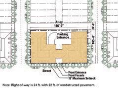
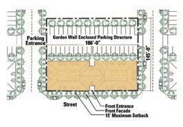
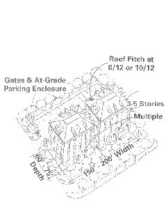
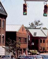
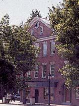
71 Illustrative Small Office Buildings Building Guidelines Small Office Buildings 4 Last Revised February 6,


72 4 Building Guidelines Medium-sized Office Buildings Five-to-eight-story office buildings are proposed in this development. They are to be located in the Town Center and near the Route 1 Bridge and the newly extended Monroe Avenue. Their floor plates range from 15,000sf to 40,000sf. All of the office buildings are permitted to have retail space such as stores, cafes, or restaurants at the ground floor. 68 Last Revised February 6, 2007 Medium-sized Office Buildings Urban Standards Frontage and Orientation Buildings shall have their front facades parallel to the front property line. No less than 80% of the front lot width should be covered by the front facade. Corner lots are considered to have two front lot lines. The main entrance to the building shall be at the front facade and articulated as a significant public entrance. Buildings surrounding the Town Green in the Town Center will be required to have retail for the entire front facade except for the building lobby entrances. The orientation of a group of buildings in the Town Center should create a positive spatial definition and be an integral part of the Town Center overall design. Buildings longer than 200ft along the front facade shall be articulated with vertical recesses or projections to break down the scale of the facade. This can be expressed by recesses or projections of the facade, or by a change of material. Height and Massing Buildings should utilize simple geometric shapes in plan and in elevation. The front facade shall be built parallel with the lot line. Buildings shall not exceed eight stories, nor shall they be less than five stores. In Town Center (Parcel G), building height up to 110ft is permitted for seven buildings, in addition to the hotel. In Parcel J, building height up to 82ft is permitted for five buildings. In Parcel L, building height up to 82ft is permitted for two buildings. Setbacks on the upper floors are encouraged, and can be used for balconies or terraces. Horizontal expressions such as a frieze band are strongly encouraged as architectural expressions. Parking and Service The majority of required parking shall be provided in underground facilities. Surface parking lots are to be at the rear and enclosed with walls. Loading areas shall be located in the back of the building and screened to minimize views from adjacent buildings and streets. Trash or dumpster enclosures or adjacent free-standing equipment must be screened on all sides and from above. Architectural Standards Fenestration and Roofscape Exterior openings should be proportionately appropriate for the building function and compatible with the adjacent development. Recessed exterior openings to simulate traditional load-bearing masonry punched-opening facade are strongly encouraged. The use of reflective or darkly tinted glass shall be restricted. The roof of the building may be either flat or pitched. A cornice or similar expression is encouraged either at the parapet or at the eave of the roof. Building wings and additions should have similar forms, roof pitch and character to the main body of the building. Mechanical or HVAC units may not be seen from the street. Materials and Architectural Elements Buildings should be predominately clad in masonry material, including brick, stone, stucco, or precast panels. Trim materials may be of stone, metal, or similar material. Architectural elements, such as awnings, window boxes, and balconies are encouraged.
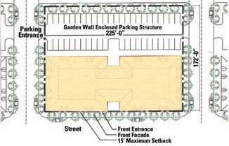
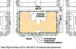
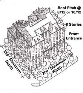

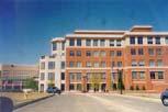
73 Building Guidelines Medium-sized Office Buildings 4 Last Revised February 6,


74 4 Building Guidelines Hotel A 625-room hotel is located in the Town Center (Parcel G). The hotel should be designed as the signature building in the Town Center providing spatial definition and a visual anchor. Urban Standards Frontage and Orientation Refer to the Large Apartment Building Guidelines, except that the front facade may be a maximum of 350ft in length. The maximum uninterrupted wall length in the front facade is 60ft before an architectural articulation is required. This can be expressed by recesses or projections of the facade, change of materials, or the use of balconies, porches or bay windows. The main entrance to the hotel shall be at the front facade and articulated as a major public entrance. the hotel. Auxiliary at-grade parking of 20 maximum spaces are permitted at the rear or sides of the hotel. Parking entrances shall be from the side or rear of the building. Loading areas shall be located and screened to minimize views of such areas from adjacent buildings and streets. Trash and dumpster enclosures or adjacent free-standing equipment enclosures shall be constructed of the same or complimentary material as that of the building, and must be screened on all sides and from above. Architectural Standards Height, Massing, and Setback Refer to the Large Apartment Building Guidelines. In addition, the first and second floor shall be built with higher ceiling heights (16ft recommended) to accommodate retail and other public functions. The building should utilize simple geometric shapes in plan and in elevation. The main body of the building may not exceed 110ft in height up to the midpoint of the roof structure. The wings of the building may not exceed 80ft in height. Parking and Service Underground parking or embedded above-grade decks are required for Fenestration and Roofscape Refer to the Large Apartment Building Guidelines. Materials and Architectural Elements Refer to the Large Apartment Building Guidelines, except that the first two floors of the building shall be clad primarily in stone and articulated as a base to be differentiated from the upper floors through the use of a frieze band or change in fenestration proportions. The roof of the parking deck shall be landscaped as a garden court. Free standing ancillary uses and small mechanical or garden structures on the roof deck must be pitch-roofed. 70 Last Revised February 6, 2007 Hotel
75 Building Guidelines Summary of Building Criteria 4 Summary of Building Criteria Last Revised February 6,
76 This page intentionally left blank.
77 Section 5: Landscape Guidelines All landscaping to comply with City Landscape Guidelines. Last Revised February 6,
78 This page intentionally left blank.

79 Landscape Guidelines Streetscape Standards: Street Trees and Associated Street Plantings Plant Material Quality and Size All plantings and installation methodologies shall conform to the City of Alexandria standards and as defined by this guideline. Plants shall be nursery-grown in accordance with the latest editions of USA Standards for Nursery Stock. Unless otherwise noted within this guideline, street trees shall be at least 3 to 3 1/2 caliper and shall begin branching no less than 5 1/2 feet from the base. Ground covers shall be established, well-rooted, in containers with no less than the minimum number and length of runners required but ANSI for pot size used. Plants shall be sized and spaced such that ground plane coverage is 90% complete within two years of installation. Consistency Spacing and Species Using a variety of street tree species at Potomac Yard is encouraged. However, each individual street shall be planted with one tree species throughout its entire length. Each species shall be installed at sizes uniform in caliper and height. North South streets must maintain size uniformity for a distance of at least one full block. Streetscape Standards: Street Trees and Associated Street Plantings 5 East West street planting must be uniform throughout the entire length of the street. Tree spacing shall also be consistent on each individual street with some allowance for conflicts with drive entrances, alleys, and underground services. With the exception of the Core Streets, the design intention is to provide a different tree species on every street. However, duplication of a particular species is permitted as long as duplication does not occur on consecutive parallel streets (repetition may not occur within a two-block span). Tree Pits Unless otherwise noted, sidewalks shall be located immediately adjacent to back of curb with street trees centered in tree pits. Tree pits shall be 4 by 10 in size with the long dimension oriented parallel to the street. Main Street and South Main Street Main Street and South Main Street shall be planted with the Core Street Tree, consistently spaced on both sides of the street throughout the entire length of the corridor. Main Street shall have sidewalks immediately adjacent to the back of the curb with street trees planted in tree pits. Street trees located along the east side of South Main Street (south of Howell Avenue) shall be planted consistently offset three feet from back of curb. Since there is not a sidewalk on the east side of South Main Street, the ground plane shall be developed as a continuation of the Potomac Yard Park design. Core Street Tree The same species of street tree shall be used for Main Street, South Main Street, East Glebe Road, Swann Avenue, Custis Avenue, and Howell Avenue. This tree shall be selected from the Broad Street Tree list and will be referenced within this guideline as the Core Street Tree. Spacing of the Core Street Tree shall be no less 25 apart, with an average spacing of 35 on center. Last Revised February 6,
80 5 Landscape Guidelines East Glebe Road and Swann Avenue (with Finger Parks) East Glebe Road and Swann Avenue shall be planted with the Core Street Tree, consistently spaced on both sides of the street throughout the entire length of each street. A double row of street trees shall be planted on the Finger Park side of the street. The first row shall be centered in a six foot continuous planting strip located immediately adjacent to the curb. A six foot wide sidewalk shall be located next to the planting strip. The second row of street trees will be offset three feet from the inside edge of sidewalk, centering the sidewalk between the double row of trees. The double tree row with sidewalk shall be installed on both sides of each finger park. The ground plane of the planting strip and park shall be lawn. The building side of the street shall be planted with a single row of trees in tree pits. 76 Last Revised February 6, 2007 Streetscape Standards: Street Trees and Associated Street Plantings Howell Avenue Howell Avenue shall be planted with the Core Street Tree, consistently spaced on both sides of the street. Except for street edges adjacent to Howell Park, street trees shall be planted in tree pits. Street edges facing Howell Park shall be planted with a single row of the Core Street Tree, offset three feet from back of curb. Ground plane treatment shall be consistent with the Howell Park Design. Route 1 Corridor Within the Route 1 corridor south of Howell Avenue, trees shall be Ginkgo Biloba matching existing street trees near Monroe Avenue. Street trees along the west edge of Route 1 and the Route 1 median shall be consistent in spacing and be of the same species from Howell Avenue to the Potomac Yard Retail Center. Tree spacing shall be no less than 25 apart, with an average spacing of 35 on center. Tree species shall be one of the specified Broad Deciduous Street Trees. The Route 1 median and the median between Route 1 and the access road shall be a continuous planting strip with street trees and lawn/ground cover. East of the access road, sidewalks shall be immediately adjacent to the back of curb with street trees planted in tree pits. Tree pits shall be planted consistently with one of the tree pit ground covers specified.
81 Landscape Guidelines Streetscape Standards: Street Trees and Associated Street Plantings 5 Potomac Avenue Typical Residential Streets Potomac Avenue shall have street trees planted on the east side, west side, and median. Trees shall be planted with consistent spacing and be of the same species through the entire length of the corridor. Tree spacing shall be no less than 25 apart, with an average spacing of 35 on center. Tree species shall be one of the specified Broad Deciduous Street Trees. Street trees located along the east side of Potomac Avenue shall be planted consistently offset three feet from back of curb. Since there is not a sidewalk on the east side, the ground plane shall be developed as a continuation of the Potomac Yard Park design. The median shall be developed as a continuous planting strip with street trees and lawn/ground cover. Sidewalks on the west side of the street shall be immediately adjacent to the back of curb with street trees planted in tree pits. Tree pits shall be planted consistently with one of the tree pit ground covers specified. Each of the Typical Residential Streets shall be planted with one of the Broad Street Trees, one species per street, each street with a different species. However, duplication of a particular species is permitted as long as duplication does not occur on consecutive parallel streets (repetition may not occur within a two-block span). Tree spacing shall be no less than neighborhood parks abut the street, all typical residential streets shall be developed with sidewalks located immediately adjacent to back of curb. Street trees shall be planted in tree pits with ground cover. Alleys Non-paved surfaces located within alley right-of-ways shall be planted and maintained by adjacent property owner. These spaces shall remain as green spaces. A variety of plantings and design is encouraged. Last Revised February 6,


82 5 78 Last Revised February 6, 2007 Landscape Guidelines Recommended Street Planting List Recommended Street Planting List Core Street Trees Quercus phellos Willow Oak Quercus palustis Pin Oak Deciduous Street Trees-Broad Streets Acer rubrum October Glory October Glory Red Maple Ginko biloba Maidenhair Tree Nyssa sylvatica Black Gum Platanus x acerifolia Bloodgood London Planetree Quercus coccinea Scarlet Oak Quercus palustris Pin Oak Quercus phellos Willow Oak Quercus rubra Northern Red Oak Ulmus parviflora Lacebark Elm Deciduous Street Trees-Narrow Streets Acer rubrum Armstrong Armstrong Red Maple Ginko Biloba Magyar Magyar Upright Ginko Tillia cordata Greenspire Little Leaf Linden Median Ground Covers Cotoneaster horizontalis Rock Contoneaster Gaultheria procumbens Wintergreen Hedera helix English Ivy Hedera helix Baltica Baltic Ivy Juniperous horizontalis cultivars Creeping junipers Vinca minor Periwinkle Lawn (see Lawns) Tree Pit Ground Covers Liriope muscari Lilyturf Liriope spicata Creeping Lilyturf Ophiopogon japonicus Mondo Grass Pachysandra terminalis Japanese Spurge Vinca minor Periwinkle

83 Landscape Guidelines Sidewalk Paving Continuous Pedestrian Circulation System Pedestrian circulation throughout the site shall be continuous. Sidewalks shall align with one another and connect to park trails and pathways, providing an unbroken circulation system. Unless otherwise noted, all streets shall be bordered with sidewalks. Except in parks, sidewalks shall be placed immediately adjacent to back of street curb with openings in the sidewalk to accommodate tree pits. Pedestrian pathways through parks shall serve as extensions to the street sidewalk system. These pathways shall always abut street curbs at intersections, aligning with crosswalks. Accessibility Sidewalks shall be constructed in accordance with all local, state, and national regulations including the latest ADA regulations. Accessibility ramps shall be provided at all street corners in accordance with the City of Alexandria standards. Sidewalk Paving 5 Crosswalks Crosswalks shall be delineated at every intersection except where noted along Route 1 and Potomac Avenue. Signalized pedestrian crosswalks along Route 1 shall be provided at the intersections with East Glebe Road, Swann Avenue, Custis Avenue, Howell Avenue and a selected location at Simpson Field and Monroe Avenue if approved by the City. Signalized pedestrian crosswalks along Potomac Avenue shall be located at East Glebe Road, Swann Avenue, Custis Avenue, Howell Avenue, and in front of the Hoyts Theaters, if approved by the City. Other signalized crosswalks (pedestrian only) may be allowed where the distance between crosswalks exceeds 800 feet. Concrete Sidewalks Concrete sidewalks shall conform to the City of Alexandria standards and include color additive per District of Columbia standard sidewalks lamp black as specified by the District of Columbia Standard Specifications for Highways and Structures. Brick Sidewalks Brick used for sidewalks shall be consistent throughout the project except for special spaces such as the Town Center and urban plazas. Compressive strength shall not be less than 10,000 pounds per square inch for any five bricks tested. Tolerances shall conform to the most current ASTM Designation C-902. Brick pavers shall be wire cut with sand swept hand tight joints. Base materials shall be designed to withstand light vehicular traffic. Design shall include a concrete base with bituminous setting bed per brick manufacturer s recommendations. Pedestrian Through Block Connections There shall be pedestrian connections extending the existing Del Ray grid across Route 1 and through the first Potomac Yard block to Main Street. Pedestrian connections shall be provided along proposed streets or as though block connections. These mid-block pedestrian connections shall be six foot wide concrete sidewalks within a minimum 20 wide right-of-way. Pedestrian through block connections shall always align with Del Ray street grid. Last Revised February 6,

84 5 Paving Systems Route 1 Sidewalks All sidewalks located along the east edge of Route 1 shall be concrete. Sidewalks shall be at a minimum of 15 wide, located immediately adjacent to the curb, and have openings to accommodate tree pits. Lay-bys designed to T&ES standards shall be considered. 80 Last Revised February 6, 2007 Landscape Guidelines Paving Systems

85 Potomac Avenue Potomac Avenue shall have a continuous sidewalk along the west edge only. Sidewalks shall be 14 wide, located immediately adjacent to the curb, and have openings to accommodate tree pits. Sidewalks shall be concrete or brick. Street tree spacing must be an average of 35 o.c., 25 min. Landscape Guidelines Paving Systems 5 Last Revised February 6,

86 5 Core Streets Core Streets are Main Street, E. Glebe Road, Swann Avenue, Custis Avenue, Howell Avenue: All Core Street sidewalks shall be minimum 14, 19 at Town Green, and constructed of brick. Paving systems for these streets shall always turn the corner at intersections with Typical Residential Streets, Potomac Avenue and Route Last Revised February 6, 2007 Landscape Guidelines Paving Systems

87 Typical Residential Streets Typical Residential Street sidewalks shall be 14 wide and paved with concrete or brick. Landscape Guidelines Paving Systems 5 Last Revised February 6,
88 5 Landscape Guidelines Street Lighting Street lighting at Potomac Yard will be consistent in style, quality, and character and compliment, in fixture selection and scale, the pedestrian emphasis of the plan. Street lighting including fixtures, power supply, and light levels shall comply with all the local, state, and federal regulations applicable for public space. Street lights shall be consistent on all streets except Route 1. Street lights along Route 1 may be consistent with the existing street lights along the corridor. Street lights shall be similar to models shown above. All street lights and lighting levels shall meet T&ES standards. Color shall be consistent throughout and shall be in the black or gray range. Street light locations shall be consistent in spacing and distance set back from curb. Street light spacing shall be coordinated with the rhythm of street tree spacing. In addition, street lights shall be located no closer than ten feet from nearest street tree. Center of pole shall be set two feet from back of curb. Street light foundations shall be concealed from view. 84 Last Revised February 6, 2007 Street Lighting and Furniture Street Furniture Site furniture at Potomac Yard shall be consistent in style, quality, and character. There will be two distinct types of bench styles at Potomac Yard: one Street Bench standard and one Park Bench standard. Although both styles shall be of the same family and constructed of the same materials, the Street Bench shall be slightly heavier in appearance. Specialty furniture for select civic spaces is permitted if the design is more fitting for those spaces. Benches Street Benches shall have hardwood slats and cast iron stanchions, resembling those in images shown. Benches shall vary from 4 to 6 in length. Bench locations shall be limited to areas in front of commercial buildings and public transportation stops. Grouping of at least two benches per location is encouraged. Trash Receptacles Trash Receptacles shall be of the same family as the bench style selected, or as required by T&ES. Models shall include an attached lid or cover for weather protection. Receptacles shall be placed at every intersection along Main Street (minimum one per intersection) and at Town Center. Bike Racks The design of bike racks shall complement the style of other street furnishings. Street Bench Park Bench


89 Landscape Guidelines Parking Lot Wall Sidewalk Street Tree Street Walls and Fences 5 Walls and Fences Within residential neighborhoods, Town Center, Howell Park, and Neighborhood Parks, walls located within public view shall be brick, stone, stucco or precast concrete. Garden walls shall be provided at the ends of row units, facing the street. These garden walls shall be six feet in height. Walls shall extend from building to garage or alley property line (see Building Guidelines). Fences Within residential neighborhoods, Town Center, Howell Park, and Neighborhood Parks, fences located in areas visible to the public shall be painted wrought iron. Wood fences, if used in other locations, shall be painted and shall not exceed six feet in height. Wood fences should not be visible from the street. Fencing required for playgrounds and recreation areas shall be architectural metal fencing similar to Legi fencing, manufactured by Outer-Space Landscape Furnishings. With the exception of active recreation court enclosures, chain link fencing shall be prohibited from public view. At Grade Parking Enclosures Parking lots located behind buildings, when visible from the street, shall be enclosed by garden walls or by a combination of walls and wrought iron fencing, accented with garden plantings. Walls and fences shall not be less than 3.5 feet in height, and shall not exceed six feet in height. Safety should be considered when determining height and material. Last Revised February 6,


90 5 Landscape Guidelines Parkscape Standards Plant Material Quality and Size All plantings and installation methodologies shall conform to the City of Alexandria standards and as defined by this guideline. Plants shall be nursery-grown in accordance with the latest edition of USA standards for Nursery Stock. Ground covers shall be established, well-rooted, in containers with not less than the minimum number and length of runners required by ANSI for pot size used. Ground cover plants shall be sized and spaced such that ground plane coverage is 90% complete within two years of installation. Potomac Yard Park Potomac Yard Park is envisioned as an informal park with naturalized plantings. Plant material species shall be predominantly native and suitable to environmental conditions of the site. There will be upland areas with dry soils and there will be wet soils in areas affected by bioretention and BMP pond edges. The park shall include a variety of spaces, some of which are tree-covered, shady areas and some that are open, sunny spaces. Tree canopy coverage of the site shall be 40% at 10 years from time of installation. There shall be a mix of shade trees, understory trees, and evergreen trees. For safety and maintenance purposes, shrub planting is discouraged. The mix of tree types by canopy coverage shall be as follows: Large Deciduous Parkland Trees (50 to 75%), Medium Deciduous Parkland Trees (5 to 10%), Understory Parkland Trees (5 to 10%), Large Evergreen Parkland Trees (0 to 15%), and Small Evergreen Parkland Trees (0 to 5%). 86 Last Revised February 6, 2007 Parkscape Standards Howell Park Howell Park is envisioned to be a large neighborhood park of either an informal or formal design. There shall be a mix of tree species with 70% tree canopy coverage of the site at ten years from time of installation. The mix of tree types shall be as follows: Large Deciduous Parkland Trees (75 to 100%), Medium Deciduous Parkland Trees (0 to 15%), Understory Parkland Trees (0 to 5%), Large Evergreen Parkland Trees (0 to 5%), and Small Evergreen Parkland Trees (0%). Potomac Plaza The neighborhood park is intended to be used by the residents of Northeast and Slaters Village, planned as a passive use park. Tree canopy coverage of the site shall be 50% at 10 years from time of installation. The mix of tree types shall be as follows: Large Deciduous Parkland Trees (75 to 100%), Medium Deciduous Parkland Trees (0 to 15%), Understory Parkland Trees (0 to 5%), Large Evergreen Parkland Trees (0 to 5%), and Small Evergreen Parkland Trees (0%). Potomac Greens Park Situated adjacent to an existing natural and wetlands area, this park is envisioned as passive recreation. Natural areas will be developed as passive parkland with boardwalks and trails that bring visitors in close contact with this sensitive environment. Sitting and picnic areas serving the passive space will be provided. Not including the multiuse field and existing protected woodland, tree canopy coverage of the site shall be 30% at ten years from time of installation. The mix of tree types shall be as follows: Large Deciduous Parkland Trees (75 to 100%), Medium Deciduous Parkland Trees (0 to 15%), Understory Parkland Trees (0 to 5%), Large Evergreen Parkland Trees (0 to 5%), and Small Evergreen Parkland Trees (0%).


91 Landscape Guidelines Parkscape Standards 5 Four Mile Run Park Located at the juncture of regional trail systems, this park is envisioned as a significant open space intended for use by both local and regional visitors. Trails connecting the Potomac Yard Park trail to the Four Mile Run trail system shall be provided. Use of a variety of plantings is encouraged. The south bank and bank top shall be heavily planted with both evergreen and deciduous materials to screen the parking areas of the Potomac Yard Retail Center. Bridge decks shall be paved with a combination of both paving and soil sufficient to sustain plant life. Since this park is envisioned as both a rest stop for bikers/hikers and a destination park, an abundance of benches, trash receptacles, and bike racks shall be used. Tree canopy coverage of the site including bridge decks but not including water surface areas shall be 20% to 40% at 10 years from time of installation. There shall be a mix of shade trees, understory trees, and evergreen trees. The mix of tree types by canopy coverage shall be as follows: Large Deciduous Parkland Trees (50 to 70%), Medium Deciduous Parkland Tress (10 to 20%), Understory Parkland Trees (10 to 20%), Large Evergreen Parkland Trees (10 to 20%), and Small Evergreen Parkland Trees (0 to 10%). Neighborhood Parks Neighborhood parks should contribute a variety of open space uses to the site, including, where space is adequate, playgrounds or tot lots. Park designs should vary throughout the site, so that each park lends character and identity unique to each neighborhood. Benches, trash receptacles, and bike racks shall be located in each neighborhood park. For safety and maintenance purposes, shrub planting is discouraged. Finger Parks These parks are envisioned as green pedestrian pass-through spaces linking the neighborhood of Del Ray to Potomac Yard. A double row of street trees shall be planted on each side of the park. Rail Park Rail Park is intended to be an unstructured open park with naturalized plantings. A portion of the park shall be for a public dog-run area, with gravel surface, fencing, water, benches and a dog waste receptacle. The remainder of the space shall be used as desired by the City; at a minimum the area shall be planted lawn. Last Revised February 6,
92 5 Landscape Guidelines Recommended Park Planting List Trees for Urban Plazas and Terraces Cercidiphyllum japonicum Katsura Tree Cladrastis lutea American Yellowwood Crataegus phaenopyrum Washington Hawthorn Ginko Biloba Maidenhair Tree (male only) Gleditsia triacanthos var. inermis Thornless Honey Locust Magnolia grandiflora Southern Magnolia Large Deciduous Parkland Trees Acer rubrum Red Maple Fagus grandifolia American Beech Fagus sylvatica European Beech Fraxinus pennsylvanica Green Ash Gymnocladus dioicus Kentucky Coffeetree Plantanus x acerifolia London Plantree Quercus alba White Oak Quercus coccinea Scarlet Oak Quercus phellos Willow Oak Quercus rubra Northern Red Oak Ulmus americana Princeton Princeton American Elm Ulmus parviflora Lacebark Elm Medium Deciduous Parkland Trees Cercidiphyllum japonicum Katsura Tree Koelreuteria paniculata Golden Rain Tree Oxydendron arboretum Sourwood Phellodendron amurense Shademaster Shademaster Amur Corktree Sophora japonica Regent Japanese Scholartree Understory Parkland Trees Amelanchier canadensis Serviceberry Cercis canadensis Eastern Redbud Cornus kousa Kousa Dogwood Carpinus caroliniana American Hornbeam 88 Last Revised February 6, 2007 Recommended Park Planting List Large Evergreen Parkland Trees Cedrus atlantica Glauca Blue Atlas Cedar Magnolia grandiflora Southern Magnolia Picea abies Norway Spruce Picea glauca White Spruce Pinus nigra Austrian Pine Small Evergreen Parkland Trees Cryptomeria japonica Japanese Cryptomeria x Cupressocyparis leylandii Leyland Cypress llex opaca American Holly Tsuga canadensis Canadian Hemlock Wet Soil Tolerant Trees Amelanchier canadensis Serviceberry Betula nigra River Birch Carpinus caroliniana American Hornbeam Fraxinus pennsylvanica Green Ash Liquidambar styraciflua Sweet Gum Magnolia virginiana Sweet Bay Magnolia Metasequoia glyptostroboides Dawn Redwood Nyssa sylvatica Black Gum Pinus nigra Austrian Pine Salix matsudana Tortuosa Corkscrew Willow Tree Pit Ground Covers Liriope muscari Lilyturf Liriope spicata Creeping Lilyturf Ophiopogon japonicus Mondo Grass Pachysandra terminalis Japanese Spurge Vinca minor Periwinkle Lawns Seed: Shall be state certified, VA/MD Approved Turf Type, and shall comply with Federal Seed Act. Sod: Shall be American Sod Producers Association (ASPA) Grade: Nursery Grown or Approved, and shall comply with ASPA classes of sod materials.


93 Path and Trail Paving Paths Park paths shall be designed to accommodate light vehicular traffic. Pavement of paths located adjacent to streets shall match sidewalk paving within the corridor. Internal paths shall be brick, concrete, asphalt, stone, or stone dust, as appropriate for the park design. Path pavements shall meet all local, state, and federal regulations for safety and accessibility. Trails Trail pavements shall be asphalt, designed to accommodate light vehicular traffic. Trails shall be 10 to 12 feet in width to accommodate two-way bike traffic and city maintenance and emergency vehicles. Trails shall be designed in accordance with American State Highway Transportation (ASHTO), Uniform Federal Accessibility Standards (UFAS), and VDOT standards. Bike trail grades, design speeds, radii and recovery zones shall comply with ASHTO s Guide for the Development of Bicycle Facilities. Trails shall meet all local, state, and federal regulations governing safety and accessibility. The trail from Four Mile Run to the Braddock Road trail system shall be continuous. Connections from Adjacent neighborhoods to the trail Landscape Guidelines must be provided at each signalized crosswalk along Potomac Avenue. Trail design shall include rest nodes along the length of the trail, furnished with benches and trash receptacles. Secondary pedestrian-only trails shall be paved with concrete, asphalt, stone, or stone dust. Boardwalks Boardwalks with railings shall be provided within the designated protected environmental areas in Potomac Greens Park. Boardwalks are intended to allow pedestrian access to nature areas located within sensitive ecosystems. All design materials and construction operations for boardwalks shall be in accordance with regulations regarding environmentally protected areas. Path and Trail Paving 5 Last Revised February 6,


94 5 90 Last Revised February 6, 2007 Landscape Guidelines Park Lighting and Furniture Park Lighting Park lights shall have the same fixture as that selected for street lights. Alternate site lights may be selected for public parks, if desired by the City. These lights should be compatible with the street light style. Park lighting shall only be required to light trails and pathways, not entire area of park. Pathways and sidewalks lit by street lights are not required to have additional park lighting. Park light foundations shall be concealed from view. Site light including fixtures, power supply and light levels shall comply with all local, state, and federal regulations applicable for public space. Park Furniture Benches Park Benches shall have hardwood slats and cast iron stanchions, or shall be teak, resembling those in images shown. The overall appearance of the Park Bench shall be slightly lighter in style than the Street Bench. Another acceptable style for the Park Bench is the DC Standard Bench for City Parks. Park Benches shall be located along bicycle/pedestrian trails, along pathways and central paved areas within parks, and at major pedestrian crossings into Potomac Park. Grouping of at least two benches per location is encouraged. Trash Receptacles Trash receptacles shall be of the same family as the bench style selected. Receptacles shall be placed in each park, and along bicycle/pedestrian trails in Potomac Park. Locations shall be coordinated with the City of Alexandria. Bike Racks The design of bike racks shall complement the style of other park furnishings. Bike racks shall be located at major pedestrian crossing points into Potomac Park, at the southernmost end of Potomac Park near Braddock Metro Station, and at park athletic fields. All Neighborhood parks shall have bike racks. Drinking Fountains Drinking fountains shall be provided in parks near centers of active recreation, public civic spaces, and trail rest nodes. Location of drinking fountains shall coincide with recreation facilities where appropriate.


95 Landscape Guidelines Recreation Facilities Recreation Facilities Recreation facilities shall be integrated as part of the proposed park designs. They shall be evenly distributed across the site, offering access to all neighborhoods. It is important that a variety of activities be included such as soccer fields, basketball courts, volleyball courts, tennis courts, playgrounds and tot lots, dog runs, fitness course, multi-purpose courts and open play areas, picnic areas, and rest nodes for hikers and bikers. Sports fields and courts shall be organized in an informal manner, allowing the pastoral design of the park to read through the sport s boundaries. Three play fields shall be provided, two adjacent to Simpson Field and one near the George Washington School. All three shall be constructed complete with surface and subsurface grading, prescription soils, irrigation systems, prescription turf and lighting, if required by the City. There shall be at least one playground or tot lot located within each of the neighborhoods as defined in the Parcel Plan. One regional playground shall be provided in Potomac Yard Park. Tot lots and playgrounds shall be designed and constructed in accordance with the latest federal, state, and local regulations and shall conform to the Consumer Product Safety Commission (CPSC) recommendations. 5 Tennis courts shall be 60 by 120 including clear zones, hard surface, drained from side to side, and long axis oriented north-south. Surround fencing shall be galvanized or vinyl coated chain link with mesh openings appropriate for tennis. Clustering two to four courts at one location is desirable. Minimum four tennis courts total. Basketball courts shall be 94 by 60 including clear zones, hard surface, drained from side to side, and long axis oriented north-south. Minimum two basketball courts total. Volleyball courts shall be 50 by 80 including clear zones, constructed of sand with permanent net system. Court design shall include subsurface drainage system. Minimum two volleyball courts total. A fitness course shall be provided along the trail planned for Potomac Yard Park. Exercise stations shall be spaced approximately 150 to 200 yards apart. Other recreation facilities are permitted as long as public safety, environmental protection, and visual quality is not compromised. Design and construction shall comply with all federal, state, and local regulations. Last Revised February 6,
96 This page intentionally left blank.
97 Section 6: Illustrative Drawings The illustrative material accompanying these guidelines show one possible build-out of the plan according to the guidelines. Recognizing that development of a large-scale project can take a decade or more, a certain flexibility is required and the final build-out may vary from the illustrative materials. The guidelines serve to preserve the design intent as approved by the public authorities and to ensure that Potomac Yard evolves as a harmonious family of buildings and open spaces, providing desirable living, working and recreational opportunities to the residents of the Yard and its surrounding neighborhoods. Last Revised February 6,
98 This page intentionally left blank.

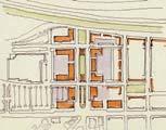
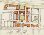
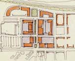
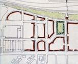
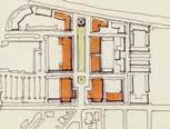
99 Town Center Illustrative Drawings Town Center 6 Last Revised February 6,


100 6 Residential Blocks Prototypical Townhouse 96 Last Revised February 6, 2007 Illustrative Drawings Residential Blocks

101 Illustrative Neighborhood Plan Illustrative Drawings Residential Neighborhood 6 Last Revised February 6,


102 6 Mixed-use Blocks 98 Last Revised February 6, 2007 Illustrative Drawings Mixed-use Blocks

103 Illustrative Route 1 Frontage Illustrative Drawings Route 1 Frontage 6 Last Revised February 6,
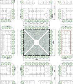
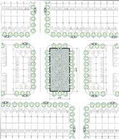

104 6 Neighborhood Parks 100 Last Revised February 6, 2007 Illustrative Drawings Neighborhood Parks

105 Potomac Greens Illustrative Drawings Potomac Greens 6 Last Revised February 6,

106 6 Overall Site Plan 102 Last Revised February 6, 2007 Illustrative Drawings Overall Illustrative Site Plan

107 Illustrative Drawings Overall Illustrative Site Plan 6 Last Revised February 6,

108 6 Overall Site Section 104 Last Revised February 6, 2007 Illustrative Drawings Overall Illustrative Site Section

109 Illustrative Drawings Overall Illustrative Site Section 6 Last Revised February 6,
WEST LOOP DESIGN GUIDELINES CHECKLIST
 WEST LOOP DESIGN GUIDELINES CHECKLIST Section 1.0 General Strategies 1.1 DESIGN EXCELLENCE: ENCOURAGE HIGH QUALITY AND INNOVATIVE DESIGN OF NEW BUILDINGS WITHIN THE WEST LOOP WITHOUT BEING PRESCRIPTIVE
Neighborhood Districts
 NEIGHBORHOOD DISTRICTS SEVEN MAIN DISTRICTS Neighborhood Districts While the Development Plan provides a broad-scale overview of the neighborhood, this section focuses on uses and relationships at the
Clairtrell Area Context Plan
 Clairtrell Area Context Plan March 2005 Urban Development Services City Planning Contents 1. Introduction... 4 2. Development Structure... 6 2.1 Streets... 7 2.1.1 Sheppard Avenue and Bayview Avenue...
Town Center. Block 5 Existing multifamily residential units are expected to remain.
 Area Guidelines Germantown s districts should be developed as distinct communities with unique features that are supported through the guidelines. The guidelines not only help distinguish these districts
3.1 community vision. 3.3 required plan elements
 Chapter 3 Community Form 3.1 community vision 3.2 Parks & landscaping concepts 3.3 required plan elements D R A F T 20 Community Form Chapter 3 3.0 Community form 3.1 community vision The Specific Plan
Table of Contents. Elm Avenue Improvement Plan City of Waco, Texas. Introduction 1. Existing Context 1 Figure 1 2.
 Table of Contents Introduction 1 Existing Context 1 Figure 1 2 Plan Guidelines 3 Future Urban Form 4 The West-End 4 Main Street 6 The East-End 7 Figure 2 9 Public Improvement Recommendations 7 General
East Bayshore Road Neighbourhood
 East Bayshore Road Neighbourhood Northridge Property Management Urban Design Brief 3195 East Bayshore Road City of Owen Sound January 2016 East Bayshore Road Neighbourhood Northridge Property Management
for Master Planned Development Framework Design Standards & Guidelines
 B L A C K D I A M O N D DE S I G N G U I D E L I N E S for Master Planned Development Framework Design Standards & Adopted June 18, 2009 Introduction and Purpose The Master Planned Development (MPD) Framework
DRAFT. October Wheaton. Design Guidelines
 October 2011 DRAFT Wheaton Design Guidelines 2 Draft - Design Guidelines - Wheaton Sector Plan Contents 04 Section 1: Introduction 06 Section 2: Context 08 Section 3: Design Guidelines 09 Goal 1: Create
Planning Board Briefing
 Planning Board Briefing Why Now? The Sector Plan Implementation Chapter States: Before Stage 1 begins, the following must occur: Approval of the Sectional Map Amendment. Approval of the Greater Lyttonsville
The open space system should provide connective elements, relate to natural resources, and enhance the suburban character of the landscape..
 The open space system should provide connective elements, relate to natural resources, and enhance the suburban character of the landscape.. Mixed-use and infill development should maintain or enhance
VEHICULAR AND PEDESTRIAN CIRCULATION
 This perspective sketch communicates the intended character and quality of a proposed streetscape design. Locate benches near a major intersection where people tend to gather. Seating and lighting provide
CHAPTER 3. Design Standards for Business, Commercial, Industrial, Recreational and Institutional Uses
 CHAPTER 3 Design Standards for Business, Commercial, Section Number Title Ordinance Number Date of Ordinance 16-3-1 Applicability 2006-11 2008-04 07-01-08 16-3-2 Uniform Standards for Architectural Design
URBAN DESIGN BRIEF URBAN DESIGN BRIEF 721 FRANKLIN BLVD, CAMBRIDGE August 2018
 URBAN DESIGN BRIEF URBAN DESIGN BRIEF 721 FRANKLIN BLVD, CAMBRIDGE August 2018 DESIGN BRIEF CONTENTS PART A 1.0 INTRODUCTION 2.0 DESCRIPTION & ANALYSIS OF SITE CONTEXT 3.0 DESIGN CONSTRAINTS AND OPPORTUNITIES
Gold Line Bus Rapid Transit Transit Oriented Development (BRTOD) Helmo Station Area Plan
 Helmo Station Area Plan") Appendix F Gold Line Bus Rapid Transit Transit Oriented Development (BRTOD) Helmo Station Area Plan Introduction and Purpose of the Plan The Gold Line Bus Rapid Transit facility is an eleven-mile dedicated
Appendix F Gold Line Bus Rapid Transit Transit Oriented Development (BRTOD) Helmo Station Area Plan Introduction and Purpose of the Plan The Gold Line Bus Rapid Transit facility is an eleven-mile dedicated
ATTACHMENT A. SILVERDALE DESIGN STANDARDS Amendments to the Waaga Way Town Center Chapter
 ATTACHMENT A SILVERDALE DESIGN STANDARDS Amendments to the Waaga Way Town Center Chapter Chapter 10. Waaga Way Town Center 10.1 Physical Identity Elements & Opportunities The Waaga Way Town Center includes
DRAFT. 10% Common Open Space
 % OF CHARLOTTE IS CATEGORIZED AS A. LAND USES : Placeholder map displaying location of Place Type GOALS: Accommodate XX% of future growth. Provide a concentration of primarily commercial and civic activity
Complete Neighbourhood Guidelines Review Tool
 Complete Neighbourhood Guidelines Review Tool Prepared By: City of Regina Planning Department October 2014 Page 1 of 14 Community Development Review Checklist for Secondary Plans and Concept Plans The
ARTICLE 6: Special and Planned Development Districts
 ARTICLE 6: Special and Planned Development Districts 6-10 Traditional Neighborhood Development (TND) District 6-10.10 Purpose and Intent The Traditional Neighborhood Development (TND) District provides
SECTION TWO: Overall Design Guidelines
 SECTION TWO: Overall Design Guidelines This section provides overall design principles and guidelines for the Gardnerville Mixed-use Overlay. They provide criteria for mixed-use places consisting of residential,
Establish a network of streetscaped vehicle and pedestrian routes that connect within and outside the Plan area.
 This Plan s urban design goals are to create an urban scale, walkable community with connections to transit, parks, and services and with amenities and facilities for residents and employees. The 1992
Throughout. square. (Crystal City Vision Plan 2050)
") 1: Terms related to the PSMP document 1 public space (see also public realm, civic space) An open space designated on the regulating plan, accessible to all, including Plazas, Mini Parks, and Neighborhoods
1: Terms related to the PSMP document 1 public space (see also public realm, civic space) An open space designated on the regulating plan, accessible to all, including Plazas, Mini Parks, and Neighborhoods
SECTION TWO: Urban Design Concepts
 SECTION TWO: Urban Design Concepts The Gardnerville Plan for Prosperity shapes economic opportunities presented by regional growth. The Urban Design Concepts provide policies and concepts for land use,
URBAN DESIGN BRIEF. 2136&2148 Trafalgar Road. Town of Oakville
 URBAN DESIGN BRIEF 2136&2148 Trafalgar Road Town of Oakville Prepared By: METROPOLITAN CONSULTING INC For 2500674 Ontario Inc November 2016 TABLE OF CONTENTS Page No. 1.0 Introduction/Description of Subject
Highland Village Green Design Guidelines
 Highland Village Green Design Guidelines Publishing Information Title Highland Village Green Design Guidelins Author The City of Calgary Status DRAFT - Proposed document subject to changes Additional Copies
B. Blocks, Buildings and Street Networks
 B. Blocks, Buildings and Street Networks Figure IV.4 A rational block pattern with connected streets Introduction The single most important element in the physical and functional integration of mixed use
Urban Design Brief Proposed Residential Development 5219 Upper Middle Road City of Burlington
 Urban Design Brief Proposed Residential Development 5219 Upper Middle Road City of Burlington Prepared by Weston Consulting Prepared for BLOOMFIELD DEVELOPMENT INC. Date: March 2017 Table of Contents 1.
Figure 3-1: Public Realm Plan
 3 Public Realm Figure 3-1: Public Realm Plan 3.1 Public Realm Concept The public realm concept for the Little Mountain site integrates a clear and accessible movement network with public spaces for social
4 C OMMUNITY D ISTRICTS
 4 C OMMUNITY D ISTRICTS N ew development in the Area will include many different types of land uses, including a destination retail area that attracts people from all over the region; recreation opportunities
Description of Preferred Alternative
 Chapter 2 Description of Preferred Alternative 2.1 Introduction This chapter of the programmatic Sammamish Town Center Sub-area Plan Final EIS provides a more detailed description of the Preferred Alternative
Metro. Activity Center Design Guidelines. Recommendations For Developing Focused, Mixed-Use Commercial/Residential Centers
 Metro Activity Center Design Guidelines Recommendations For Developing Focused, Mixed-Use Commercial/Residential Centers Metro Activity Centers What is a MAC? Legacy, the adopted guide for the future growth
VILLAGE OF SKOKIE Design Guidelines for Mixed-Use Districts NX Neighborhood Mixed-Use TX Transit Mixed-Use CX Core Mixed-Use
 VILLAGE OF SKOKIE Design Guidelines for Mixed-Use Districts NX Neighborhood Mixed-Use TX Transit Mixed-Use CX Core Mixed-Use TABLE OF CONTENTS CHAPTER 1 SITE DESIGN Purpose 1 CHAPTER 2 SITE DESIGN Streetscape
Seneca Meadows. Block 4 Locate office, technology, and medical development adjacent to I Screen views of garage structures from I-270.
 Seneca Meadows Seneca Meadows has an industrial park in its southern end and a mixed-use employment area planned for the north end. The district benefits from extensive I-270 visibility, stream valley
2. Form and Character. 2.1 Introduction. 2.2 The Downtown Addition Plan. 2.1 Introduction
 2.1 Introduction 2.1 Introduction This section of the Specific Plan describes and illustrates the desired form, character and uses of the Downtown Addition and explains the underlying design principles.
SPRINGHILL LAKE TRANSIT VILLAGE
 Greenbelt Metro Area Sector Plan - Subarea Design Policies and Guidelines - Springhill Lake Transit Village 113 SPRINGHILL LAKE TRANSIT VILLAGE Residential Neighborhood and Village Center CONCEPT Springhill
4.0 Design Guidelines For The Village Centre. South fields Community Architectural Design Guidelines Town of Caledon
 4.0 Design Guidelines For The Village Centre 4.0 Design Guidelines for the Village Centre The Village Centre is the focal point of the entire South Fields Community and is designed as a traditional commercial
ARTICLE 13 STREETS General
 ARTICLE 13 STREETS 13.1 General Streets shall be designed to suit their functions. Many streets have purposes other than vehicular traffic. As an alternative to current N.C. Department of Transportation
Policies and Code Intent Sections Related to Town Center
 Policies and Code Intent Sections Related to Town Center The Town Center Vision is scattered throughout the Comprehensive Plan, development code and the 1994 Town Center Plan. What follows are sections
The Village. Chapter 3. Mixed Use Development Plan SPECIFIC PLAN
 The Village SPECIFIC PLAN Chapter 3 3.1 INTRODUCTION 3.1.1 Purpose This Chapter describes the development regulations applicable to the Mixed-Use and Transit Center Planning Areas. These form-based regulations
Bourne Downtown Site Planning
 Prepared for: The Town of Bourne, MA In Cooperation with: Bourne Financial Development Corporation Prepared by:, Inc. June 24, 2009 Table of Contents Introduction and Summary... 1 Site Existing Conditions...
Appendix C: Interim Mixed-Use Evaluation Criteria
 Appendix C: Interim Mixed-Use Evaluation Criteria C-1 Appendix C: Interim Mixed-Use Evaluation Criteria PURPOSE: The implementation of numerous policies contained within the Master Plan hinges on the creation
PUBLIC RIGHT-OF-WAY IN THIS CHAPTER PUBLIC REALM
 PUBLIC RIGHT-OF-WAY This section provides design guidelines for improvements in the public right-of-way. The public right-of-way refers to streets, sidewalks, non-vehicular thoroughfares, parks and greenways
Westwind Developments Ltd. PIONEER LANDS AREA STRUCTURE PLAN - PROPOSED AMENDMENT
 FEBRUARY 2013 TABLE OF CONTENTS 1.0 BACKGROUND... 1 1.1 Amendment... 1 2.0 LOCATION & CONTEXT... 2 2.1 Land Ownership... 2 3.0 POLICY CONTEXT... 3 3.1 Municipal Development Plan... 3 3.2 Capital Region
5.1 Site Plan Guidelines
 5. Community Core Guidelines Development of the Community Core will take place by plan of subdivision and site plan approval. It will occur in a phased manner that will reflect the timing of residential
FLORIN ROAD CORRIDOR Site Plan and Design Review Guidelines Checklist
 FLORIN ROAD CORRIDOR Site Plan and Design Review Guidelines Checklist Applicant s Name: Project Address: Phone: Email: Applicant shall fill out the design guidelines checklist for all guidelines applicable
Buildings may be set back to create small plazas provided that these setbacks do not substantially disrupt the street wall s continuity.
 6-22 Community Design Street Walls and Street-front Setbacks The siting of buildings will play a critical role in establishing the character and sense of place for the District. Siting buildings at the
R STREET CORRIDOR NEIGHBORHOOD Site Plan and Design Review Supplemental Guidelines Checklist
 R STREET CORRIDOR NEIGHBORHOOD Site Plan and Design Review Supplemental Guidelines Checklist Applicant s Name: Project Address: Phone: Email: Applicant shall fill out the design guidelines checklist for
Planning Districts INTRODUCTION
 INTRODUCTION To facilitate detailed examination of development prospects for all areas of the community, Delano has been divided into 14 planning districts. The location of these planning districts is
Derry Green Corporate Business Park
 Town of Milton Derry Green Corporate Business Park Urban Design Guidelines BMI/Pace - June 2010 Draft 3 Prepared by: Brook McIlroy Planning + Urban Design / Pace Architects Suite 300-51 Camden Street Toronto,
Rosslyn Plaza PDSP (SP #422) SPRC Staff Presentation
 SPRC Staff Presentation") Rosslyn Plaza PDSP (SP #422) SPRC Staff Presentation ote Guiding Principles included in this document are taken from the latest working draft of the Guiding Principles dated. The illustrations included
Rosslyn Plaza PDSP (SP #422) SPRC Staff Presentation ote Guiding Principles included in this document are taken from the latest working draft of the Guiding Principles dated. The illustrations included
HIGHLAND VILLAGE GREEN URBAN DESIGN PRINCIPLES/GUIDELINES
 URBAN DESIGN GUIDING PRINCIPLES/GUIDELINES CONTEXT/CHARACTER The City of Calgary s Municipal Development Plan (MDP), Transit-Oriented Development (TOD) Policy Guidelines and Main Street/Corridor policy
Regency Developments. Urban Design Brief. Holyrood DC2 Rezoning
 Regency Developments Urban Design Brief Holyrood DC2 Rezoning Stantec Consulting Ltd. 7-31-2017 1. Overview Regency Developments intends to rezone the lands located at 8510 and 8511 93 Avenue, within the
Bylaw No. B-03/2011 Adopted by Airdrie City Council February 21, 2012
 COOPER S CROSSING STAGE 4 Neighbourhood Structure Plan City of Airdrie WESTMARK HOLDINGS LTD. Bylaw No. B-03/2011 Adopted by Airdrie City Council February 21, 2012 CONSULTANTS: LAND USE PLANNING: Southwell
1.0 VISION STATEMENT. December 6, PRINCIPLES
 Vision Statement Lincoln Regional Airport 1.0 VISION STATEMENT 1.1 City LOCATION of AND OVERVIEW The Easton Lincoln Place Land Use Master Plan identifies the principles, goals, policies, and standards
Community Design Plan
 Gardena General Plan 2006 Authority While the is not a required element of a General Plan, it is included because improving the community appearance and image is paramount to the overall quality of life
Section 9 NEIGHBORHOOD DESIGN
 Section 9 NEIGHBORHOOD DESIGN City of Lancaster Comprehensive Plan D u n k i n, S e f k o & A s s o c i a t e s, I n c. NEIGHBORHOOD DESIGN INTRODUCTION There are many ways in which a neighborhood can
II. SINGLE FAMILY RESIDENTIAL
 II. SINGLE FAMILY RESIDENTIAL Castle Rock is made up of numerous individually built houses and subdivision tracts that have been developed during the past century. Some of the tracts are diverse in architectural
Civic Center District
 Civic Center District The Civic Center district is the civic and social heart of Warrenville, containing such public buildings as the City Hall, Warrenville Public Library, Police Station, Park District
LOW DENSITY RESIDENTIAL
 LOW DENSITY RESIDENTIAL Corner lots with coach houses to increase diversity, provide unity to the streetscape and increase eyes on the street. Garages and ancillary units accessed via rear lanes. Parking
New-Cast Mixed-use Development Proposal King Street West, Newcastle, Ontario
 URBAN DESIGN BRIEF New-Cast Mixed-use Development Proposal King Street West, Newcastle, Ontario TABLE OF CONTENTS: 1.0 Executive Summary 2.0 Creating Vibrant and Sustainable Urban Places: Excerpts from
Courthouse Square Planning & Urban Design Study. Courthouse Square Working Group #13 October 15, 2014
 Courthouse Square Planning & Urban Design Study Courthouse Square Working Group #13 October 15, 2014 1 Courthouse Square Process Working Group Community Courthouse Square Advisory Groups & Civic Associations
Transportation. Strategies for Action
 Transportation A major priority for the Overlake Neighborhood is to develop a multimodal transportation system. To achieve this system, a balance has to be found among travel, circulation and access needs;
B L A C K D I A M O N D D E S I G N G U I D E L I N E S for Multi-family Development
 B L A C K D I A M O N D D E S I G N G U I D E L I N E S for Multi-family Development Adopted June 18, 2009 This section of the Design and focuses on site planning and design guidance for new multi-family
Appendix A COMMUNITY IMPROVEMENT PLAN DESIGN GUIDELINES
 Appendix A COMMUNITY IMPROVEMENT PLAN DESIGN GUIDELINES INTRODUCTION The continuous and desirable improvement of Arnprior requires a clear understanding of what is envisioned for the Town. These Design
11.5 Kipling Avenue Corridor Secondary Plan
 11.5 Kipling Avenue Corridor Secondary Plan ADOPTED BY VAUGHAN CITY COUNCIL NOT YET APPROVED BY THE ONTARIO MUNICIPAL BOARD 11.5.1 Development Principles and Objectives The following principles support
ARTICLE 13 STREETS General
 ARTICLE 13 STREETS 13.1 General Streets shall be designed to suit their functions. Many streets have purposes other than vehicular traffic. As an alternative to current N.C. Department of Transportation
1 Adapted from the Statewide Transit-Oriented Development Study by CalTrans, 2006
 APPENDIX C: LAND USE PLANNING FOR ENHANCED RAIL SERVICE 72 BACKGROUND One of the consistent themes heard from localities in the Route 29 corridor Planning Forums was the need for expanding rail service
PROPOSED REDEVELOPMENT OF THE GLEN ABBEY GOLF CLUB. STREETSCAPE DESIGN STUDY (excerpt from the Urban Design Brief) TOWN OF OAKVILLE.
 TOWN OF OAKVILLE.") PROPOSED REDEVELOPMENT OF THE GLEN ABBEY GOLF CLUB STREETSCAPE DESIGN STUDY (excerpt from the Urban Design Brief) TOWN OF OAKVILLE OCTOBER, 2016 for 2.4.2 STREETS Streets are the single largest component
PROPOSED REDEVELOPMENT OF THE GLEN ABBEY GOLF CLUB STREETSCAPE DESIGN STUDY (excerpt from the Urban Design Brief) TOWN OF OAKVILLE OCTOBER, 2016 for 2.4.2 STREETS Streets are the single largest component
The transportation system in a community is an
 7 TRANSPORTATION The transportation system in a community is an important factor contributing to the quality of life of the residents. Without a sound transportation system to bring both goods and patrons
Wide asphalt driveway abutting school property. garage built with incompatible materials, too close to park. incompatible fencing materials
 Wide asphalt driveway abutting school property incompatible fencing materials garage built with incompatible materials, too close to park Lack of plantings as a buffer between private property and open
401/Keele Provincial Campus Ontario Realty Corp.
 1.0 INTRODUCTION 1.1 Site Location and Description The study area consists of approximately 74 acres (30 ha) located in the Keele Street and Wilson Avenue area. It is bounded by Wilson Avenue to the north,
Sheridan Boulevard S TAT I O N A R E A P L A N S H E R I D A N B O U L E VA R D S TAT I O N A R E A P L A N
 Sheridan Boulevard S TAT I O N A R E A P L A N 1 City of Lakewood Adopted November, 2006 S H E R I D A N B O U L E VA R D S TAT I O N A R E A P L A N The Vision The City of Lakewood s overall vision is
McDonald s Restaurant - Purcellville Town of Purcellville Special Use Permit Statement of Justification July 24, 2014
 Introduction / Written Statement McDonald s Restaurant - Purcellville McDonald s Corporation is proposing to redevelop the existing McDonald s eating establishment with a drive-through located at 121 N
1. General Purpose. 3. Uses
 1. General Purpose The purpose of this DC1 Provision is to facilitate the development of a pedestrian friendly Community Commercial Centre that may accommodate a range of commercial, residential, office,
Urban Design Brief. Watson Parkway North & Watson Road North Guelph, Ontario. Prepared by Coletara Development
 Urban Design Brief Watson Parkway North & Watson Road North Guelph, Ontario Prepared by Coletara Development December, 2013 Urban Design Brief, Coletara Development 1 Introduction This Urban Design Brief
City of Farmington. Downtown Plan. Amendment to the 1998 Master Plan Adopted October 11, 2004
 City of Farmington Amendment to the 1998 Master Plan Adopted October 11, 2004 Introduction Planning Background 1 Scope and Components of the Plan Amendment 2 Concept Introduction 3 Plan Concepts 3 Conceptual
Chapter 6--Urban Design
 6.1 Introduction... 6-1 6.1.1 Background & Scope... 6-1 6.1.2 Relationship to State Law... 6-2 6.1.3 Relationship to Other General Plan Chapters... 6-2 6.2 Guiding Principles... 6-2 6.3 Urban Design Guidelines...
Tel: (705) Fax: (705)
 Fax: (705)") 521 and 525 Essa Road City of Barrie Tel: (705) 812-3281 Fax: (705) 812-3438 Email: INFO@IPSCONSULTINGINC.com 1 5 0 D U N L O P S T R E E T E A S T, S U I T E 2 0 1, B A R R I E O N T A R I O L 4 M 1 B
521 and 525 Essa Road City of Barrie Tel: (705) 812-3281 Fax: (705) 812-3438 Email: INFO@IPSCONSULTINGINC.com 1 5 0 D U N L O P S T R E E T E A S T, S U I T E 2 0 1, B A R R I E O N T A R I O L 4 M 1 B
Status Update (2006 vs. Now) Citizen s Advisory Committee February Plan for Prosperity
 Citizen s Advisory Committee February Plan for Prosperity") Status Update (2006 vs. Now) Citizen s Advisory Committee February 2018 Plan for Prosperity 2000 2017 2000 2017 Gardnerville Population 6,000 5,760 5746 5,500 5,000 5,067 5,550 5,165 5,394 5,412 5,250
Status Update (2006 vs. Now) Citizen s Advisory Committee February 2018 Plan for Prosperity 2000 2017 2000 2017 Gardnerville Population 6,000 5,760 5746 5,500 5,000 5,067 5,550 5,165 5,394 5,412 5,250
Design Guidelines. Roosevelt. Mike Podowski DPD Design Guidelines Ordinance ATT 13 August 13, 2012 Version #1
 Roosevelt Design Guidelines The Roosevelt Neighborhood Design Guidelines apply within the Neighborhood Boundary. Map 1 2 Map 2 3 Map 3 4 CS1 Natural Systems and Site Features Citywide Guideline: Use natural
ARLINGTON COUNTY, VIRGINIA
 ARLINGTON COUNTY, VIRGINIA County Board Agenda Item Meeting October 15, 2005 DATE: September 28, 2005 SUBJECT: Request to Advertise the adoption of the 2005 Clarendon Sector Plan C. M. RECOMMENDATION:
Supplemental Design Guidelines
 Supplemental Design Guidelines 65 SUPPLEMENTAL DESIGN GUIDELINES As a supplemental reference to the project, the following diagrams are included to illustrate the site planning approaches that were followed
SUBCHAPTER 4-B GUIDELINES FOR THE B-3 COMMERCIAL CHARACTER AREA
 1 SUBCHAPTER 4-B GUIDELINES FOR THE B-3 COMMERCIAL CHARACTER AREA Downtown Bozeman should be the location of buildings of greatest height and intensity in the community. The following guidelines apply
Cit of Kitchener Ur 6 an Design Manual PARTA. Desi n for _--::
 Cit of Kitchener Ur 6 an Design Manual Date PARTA Year ) Desi n for k Nodes Corridors _--:: Section Page 01 of 12 2 INTRODUCTION Purpose & Application Nodes and Corridors have been identified as key intensification
Hockessin Community Redevelopment Plan
 Hockessin Community Redevelopment Plan 3.1 Introduction The Community Redevelopment Plan for the Village of Hockessin is the result of the people s vision for a distinct village center that serves as the
BE IT ORDAINED by the Board of Supervisors of Chesterfield County:
 Attachment A AN ORDINANCE TO AMEND THE CODE OF THE COUNTY OF CHESTERFIELD, 1997, AS AMENDED, BY AMENDING AND REENACTING SECTIONS 19.1-52, 19.1-53, 19.1-236, 19.1-247, 19.1-253, 19.1-263, 19.1-341, 19.1-346,
Wadsworth Boulevard S TAT I O N A R E A P L A N
 Wadsworth Boulevard S TAT I O N A R E A P L A N City of Lakewood Adopted November, 2006 The Vision The City of Lakewood s overall vision is to transform the area around the light rail station into a mixed-use
2.0 AREA PLANS. Lakeside Business District. Lakeside Business District Land Use Categories:
 Lakeside Business District Lakeside Business District Land Use Categories: Campus Commercial Campus Commercial means a mixture of uses which includes corporate offices, office parks, hotels, commercial,
DRAFT ROOSEVELT ROAD. District Recommendations. Figure 5.23 The Roosevelt Road Corridor
 CHAPTER 5 Figure 5.23 The Road Corridor Road will develop as a mixed-use corridor, emphasizing regional retail, west of the river and mixed-use development east of the river. KEY RECOMMENDATIONS 1. High
Asbury Chapel Subdivision Sketch Plan
 Asbury Chapel Subdivision Sketch Plan PART 1: PROJECT SUMMARY Applicant: NVR Inc. Project Size: +/- 76.13 acres Parcel Numbers: 02101112,02116101,02116112, 02116113 Current Zoning: Transitional Residential
URBAN DESIGN BRIEF 181 Burloak Drive, Oakville
 URBAN DESIGN BRIEF 181 Burloak Drive, Oakville February 2017 Our File: 1730B 230-7050 WESTON ROAD / WOODBRIDGE / ONTARIO / L4L 8G7 / T: 905 761 5588/ F: 905 761 5589/WWW.MHBCPLAN.COM TABLE OF CONTENTS
PINE CURVE REZONING. BACKGROUND Purchased as two parcels in 2001 and 2002
 BACKGROUND Purchased as two parcels in 2001 and 2002 WHAT THE PROJECT IS AND IS NOT A Rezoning establishes the land use standards for Annexed and Zoned Greater Downtown District Historic Center September
Wheaton CBD & Vicinity Sector Plan D E S I G N G U I D E L I N E S
 Wheaton CBD & Vicinity Sector Plan D E S I G N G U I D E L I N E S 1 a b s t r a c t This document contains the design guidelines the property owners, community members, and planners should use to implement
Section4 Design Vision & Implementation Plan
 Section4 Design Vision & Implementation Plan W Woodschurch Rd 4.1 Design Focus Areas The Framework Plan is simply the starting point for directing the design and implementation of a wide range of transportation
3.0 URBAN DESIGN. December 6, OVERVIEW
 Urban Design 3.0 URBAN DESIGN December 6, 2007 3.1 OVERVIEW The highly urban character of Easton Place is defined by the overall design of the community. The following sections provide an overview of the
THE NEIGHBORHOOD TODAY
 THE NEIGHBORHOOD TODAY CORE AREA VISION How are we Good Urbanism A Site s DNA thinking about Elements of great Unique elements urban communities embedded in a place the site and design? ELEMENTS LIKE:
A. Background Summary of Existing Challenges and Potential Possibilities. 1. Summary of Existing Assets and Potential Opportunities
 A. Background 1 A Main Street Master Plan Study was performed and completed in October of 2007. The study was initiated to review current land uses and development patterns along Main Street, from Parrish
PUBLIC REALM DESIGN PLAN APRIL, 2012
 PUBLIC REALM DESIGN PLAN APRIL, 2012 Introduction NoMa is growing quickly. Fueled by transit accessibility, proximity to both Downtown and Capitol Hill and streamlined entitlements, the neighborhood has
OPEN SPACE TYPES. SIZE 8 acres. SIZE 20 acres. SIZE 1 acre
 TYPICAL CHARACTERISTICS OPEN SPACE TYPES OPEN SPACE TYPES The neighborhood contains an extensive variety of open space types. Most of these spaces incorporate multiple uses and activities, so that each
Additional information about land use types is given in Chapter 5. Design guidelines for Centers and Neighborhoods are given in Chapter 7.
 4. Place Types Introduction In Albemarle County s Development Areas, the Neighborhood is the fundamental unit of community planning. The County s Neighborhood Model, an adopted part of the Comprehensive