Keuka Lake Watershed Viewshed Identification and Prioritization
|
|
|
- Tracey Morgan
- 6 years ago
- Views:
Transcription


1 Keuka Lake Watershed Viewshed Identification and Prioritization Developed at Cornell University in the College of Architecture, Art, & Planning in the City & Regional Planning Fall 2014 course Land Use & Environmental Planning Workshop by Professor George Frantz
2 Keuka Lake Watershed Viewshed Identification and Prioritization Compiled By: Allan Franklin Alina Alam Andrew Stasiuk Gideon Ponio Laura Kenny Malia Teske Mallory Barker Michael Jahnle

3 Introduction The purpose of this study is to identify specific viewpoints and viewsheds in the beautiful Keuka Lake watershed that should be preserved for tourists and local residents to enjoy. This report is a continuation of studies performed in the Keuka Lake watershed in Fall 2012 and Spring 2014 workshops as a part of an overall Strategy for a Sustainable Keuka Lake Local Waterfront Revitalization Plan for the lake. This study synthesizes knowledge and tools of land use and open space planning, agricultural lands protection and infrastructure policy, as well as creates an inventory of scenic viewsheds in the watershed, which are identified by analyzing sites through a methodology developed by the US Forest Service, NYS Department of Environmental Conservation and other sources. The study also serves to create a nomination and protection plan that identifies scenic byways that are key viewpoints to protect; this includes special scenic, historic, recreational, cultural, archeological, and/or natural qualities of key state and local highways within the watershed. The beauty of Keuka Lake supports a major tourism industry in the region, and the landscape is a complex mix of natural and cultural landscape, which is everchanging. Different stakeholders believe in preserving different aspects of the environment, whether the landscape serves a purpose that caters to agriculture, wetlands, views, or historic landmarks.
4 Regional Context This section is intended to provide the reader with a general overview of the Keuka Lake Watershed regional context: its geologic origins, history, and community character. Readers should refer to the resources referenced to gain deeper insight pertaining to the subject area. Within the Finger Lakes region of western New York, the Keuka Lake Watershed lies within both Steuben and Yates County and spans 13 municipalities:. Eighth of the 13 municipalities have lakeshore frontage (six towns and two villages): Milo, Barrington, Wayne, Hammondsport, Urbana, Pulteney, Jerusalem, and Penn Yan. Of these municipalities, the town of Jerusalem, which contains the largest percentage of the watershed, also has the most lakeshore property. The Keuka Lake Watershed is a uniquely beautiful land, appreciated for its topography, charm, and picturesque rural landscape. Such unspoiled beauty has made the area a tourist attraction for residents of the upstate region and beyond. In recent years, however, the Keuka Lake Watershed has come to face pressure from development and commercialization. The communities of the area recognize the need to protect the region s agriculture and safeguard the natural features that contribute to the beauty of the lake and its surrounding towns and villages.
5 Geologic History Glacial movement has proven to be the most defining attribute of the Keuka Lake Watershed and the Finger Lakes region as a whole. Advances and retreats of huge sheets of ice, caused by changes in the climate, characterize the Ice Age. The first glacier, the Kansan Glacier, began its movement across the continent approximately one million years ago and is largely responsible for the landscape as we see it today. The second glacier, the Wisconsinan Glacier, was withdrew 13,000 years ago, leaving behind rock deposits such as drumlins, esters, moraines, kames, and erratics, which remain important elements of the landscape. The movement of these two glaciers caused the deep and narrow lakes of the region to form as well as the hanging valleys, steep slopes, rounded hills, gorges, and waterfalls. The resulting steep slopes often exceed 45 percent, particularly along the Bluff and western shores of Keuka Lake. While such steep slopes limit the area available for sustainable development, these slopes also assist in establishing the views and view sheds, which visually define the watershed. The glacial movements that visually defined the watershed have also played a significant role determining the location and quality of agricultural land. In the Finger Lakes region, the two most critical factors in determining soil characteristics are source rocks and topography. The bedrock of the Keuka Lake watershed consists of sedimentary rocks deposited 375 to 360 million years ago during the Middle and Upper Devonian Period.
6 Geologic History The fact that much of the best agricultural land is located in the northern part of the Keuka Lake Watershed is a result of a significant limestone presence in the area. The bands of limestone have high a lime content, which has proven beneficial for growing crops.
7 Historical Context People settled in the Keuka Lake Watershed shortly after the Ice Age ended, some 9,000 years ago. These first settlers supported themselves by hunting, fishing and gathering wild food. The Owasco people first brought agriculture to the area some 900 years ago. Archaeologists have identified the Owasco as the Iroquoian ancestors in New York. They were farmers whose lives centered on raising the three sisters : corn, beans, and squash. Later, early European explorers of the Keuka Lake Watershed encountered the Iroquois, who are thought to have arrived five hundred years ago. The Seneca tribe remained in the watershed until they were driven out by colonists following the Revolutionary War. The Seneca people called the area "O go yaga", which translated as "the promontory" and probably referred to Bluff Point. Other sources claim that "Keuka" can be interpreted as "bent elbow". The land of the Keuka Lake Watershed remained almost completely covered in forest through the early 1770s. In 1787, followers of the "Public Universal Friend", whose teachings were influenced by Quakerism and the Shaker movement, traveled to the watershed to find a new settlement. When they arrived, they found several colonists the Seneca people had permitted to reside in the area. The inflow of new settlers prompted the building of dams and mills on Keuka Lake.
8 Historical Context These first settlers contributed the name "Esperanza" to Bluff Point and those who arrived shortly after, managed to clear practically all of the forested land within the watershed for farms. With no way of distinguishing between good and poor land for farming, land that was found to be unfit was abandoned and reforested. Early settlers established lumbering and agriculture industries in the Keuka Lake Watershed. Lumbering was the primary industry in the area until the mid 1800s. As the lumber industry began to taper off, the transport of agricultural produce began to rise. This was made possible by the completion of two significant canals. In the 1830s, the Crooked Lake Canal, which paralleled the Outlet of Keuka Lake, opened. This allowed agricultural produce of the area to reach Seneca Lake and the Erie Canal system, which opened in Steamboats became a staple feature of the lake, carrying produce and passengers both north and south. In the 1830s, the first vineyards were planted in the Keuka Lake Watershed. The introduction of special vine varieties and the vitis vinifera vintages in particular sparked a winemaking renaissance throughout the Finger Lakes. The vineyards within Keuka Lake Watershed are located on the steep hillsides overlooking the lake. This gives the vines optimal drainage, better exposure to the sun, and a reduced risk of frost. The height of agricultural production in Keuka Lake Watershed occurred before the turn of the 20 th century, after which the area s agricultural sector began to decline rapidly.
9 Historical Context At the same time that agriculture was declining, tourism and recreational uses of the lake were increasing. Competing steamboat companies began carrying more sightseeing passengers and less freight as the century progressed. The second half of the 19 th century saw the first additions of resorts, summer cottages, and retirement homes to the Keuka lake shore. Some homes and establishments were in fact accessible only by steamboat. In the 1890s, Keuka College was founded, numerous nature study camps were established, and Electric Park, an amusement park on the Bluff, began operation. After the turn of the century, two industries sprang up in the Keuka Lake Watershed that would have a lasting impact on the community: Curtiss Aircraft in Hammondsport (1910) and Penn Yan Boat (1921). Prohibition and the Great Depression that followed severely hurt the local wine industry and others relying on grape growing. Local manufacturing and farming also declined during this time. By the 1930s, many farms in the watershed lay idle, belonging to Federal land bank programs. It was not until the 1960s that the wine and grape industry made a recovery in the region as a whole. Since the 1920s, much of Keuka Lake s shoreline has been developed for cottages and second homes. Additionally, the success of automobiles and the growth of a modern road system dramatically influenced the continued development of the lakeshore. In 1938, NYS Route 54 was moved away from the eastern shore of the east branch to provide more room at the shoreline for residential development. Summer homes also began to be constructed on the west sides of both northern branches.
10 Community Character According to the Keuka Lake Watershed Land Use Planning Guide, which was prepared by the Genesee/Finger Lakes Regional Planning Council in 2009: 54 percent of the watershed land is covered with shrubs, early successional trees, and/or mature forests, 31 percent of the watershed land is primarily used for agriculture, and three to five percent of watershed is used for residential, commercial and industrial purposes. Recent trends in the watershed include development on steeper slopes, conversion of summer homes to year round use, demolition and rebuilding of structures, and development of woodland and lake view parcels. The density of development and the existing utilities and services around the perimeter of the lake have resulted in an "urban corridor" surrounding the lake. The rate of development has been increased by the lake's proximity to urban centers and the availability of good highways. The lake, wineries, and abundance of recreational activates continue to attract visitors and new residents to the Keuka Lake Watershed. The Finger Lakes region produces more gallons of wine and is home to more wineries than any other wine producing region of New York State. Yates County is currently home to more wineries than any other county in the state; Steuben County also has well above the average number of wineries. Keuka Lake wineries offer many different types of wines, ranging from dry to sweet, fruity to austere, hybrid to native. There is a wine for everyone, and each winery also has its own unique restaurants, merchandise, tasting rooms, and incredible views of the watershed.
11 Community Character The picturesque landscapes and rural character preserved by working agriculture also attract visitors and residents to the Keuka Lake Watershed. Agriculture plays a significant role in preserving the watershed s rural character and scenic views by protecting open space and natural resources. In the face of development pressures, farming activities have continued to decline. This has made the Mennonite Community a welcomed new population. The recent growth of the Mennonite community in the Keuka Lake Watershed has been beneficial because abandoned farms have once again become productive agricultural lands. In addition to preserving open space, Mennonite families have rehabilitated and refurbished historic farmsteads, improving the overall aesthetic quality of the landscape. Furthermore, agriculture discourages suburban sprawl and steers development toward hamlets and villages within the watershed. There is a direct relationship between farming and the attractiveness of Keuka Lake Watershed as a place to both live and visit.


12 Land Overview This map (figure 1) of the Keuka Lake Watershed and surrounding areas provides a good overview of the character of the region. It shows public open spaces, private or institutional spaces, cemeteries, and wetland areas.
13 Local Waterfront Revitalization Plan The plan calls for certain actions to occur to The Keuka Lake Waterfront Revitalization and Scenic Viewshed Protection Plan is a great example for the Field Workshop, Fall 2014 class to use as a benchmark for our plan. The 52 page document outlines the class task and approach to the project, as well as methodology for identifying lands that are ideal protection sites, as well as the tools for how to implement change. This plan generally serves to contribute as a viewshed planning report to the Local Waterfront Revitalization Plan for the lake. The plan stresses the importance of community ownership, strengthening community involvement, establishing partnerships between public and private sectors, and building awareness of the possibilities to preserve the beautiful lake environment. promote community ownership of the Keuka Lake watershed, including 1. Convene stakeholders, 2. Survey public, 3. Identify appropriate tools, 4. Create prioritization method, and 5. Match tools to identified areas. The Fall 2014 class completed similar calls to action to provide a possible product outcome. The plan outlines tools for achieving lasting change in the Keuka Lake watershed, such as purchase of development rights, preserving public lands and right of ways, creating scenic byway destinations, and identifying possible scenic viewshed preservation tax districts. The Fall 2014 report also looks at these subjects as tools for the further preservation of the Keuka Lake watershed, and use the Waterfront Revitalization and Scenic Viewshed Protection Plan as a guide and framework for our plan.
14 Local Initiatives Name Comprehensive Development Strategy More Information Created by the Genesee/Finger Lakes Planning Council, the document outlines the economic conditions of Yates County A Draft Proposal to Protect and Improve Keuka Lake July, 1993 Keuka Watershed Improvement Cooperative Branchport Hamlet Master Plan Collaborative Watershed Management in the Finger Lakes, New York Available through Southern Tier Central Peter Landre and Lester Travis Comprehensive Plan for the Town Of Barrington Comprehensive Plan for the Town Of Milo Guide To Local Planning For Agriculture in New York New York State Department of Agriculture and Markets for the American Farmland Trust
15 Local Initiatives Name More Information Hammondsport Urbana Waterfront Revitalization Plan Jerusalem, NY Local Waterfront Revitalization Strategy Available Through Southern Tier Central Available Through Southern Tier Central Keuka Lake Watershed Land Use Planning Guide Created by the Genesee/Finger Lakes Planning Council, 2009 Regional Comprehensive Economic Development Strategy (2008 update) Created by Southern Tier Central, the document outlines the economic conditions of Steuben County. Town of Jerusalem 2006 Comprehensive Plan Town of Wayne Comprehensive Development Plan Town of Wayne, Land Use Regulations Available Through Southern Tier Central
16 Local Initiatives Location Current Land Use Regulations/Law Town Of Jerusalem Has identified specific slopes to be protected from development. Current Comprehensive Plan recommends developing regulations to oversee development in steep slope areas. Town Of Milo Currently no commentary on steep slopes in comprehensive plan. Plan recommends specific steep slopes for grape growing. Town Of Barrington Current comprehensive plan recommends that certain steep slopes overlooking Keuka be protected from poor development designs. Comprehensive plan also suggests town work to maintain as many trees on steep slopes as possible. Town Of Urbana/Village of Hammondsport Comprehensive plan references problems with building on steep slopes and offers a map to outline specific dangers. Town Of Wayne Comprehensive plan includes broad suggestions on slope development and a breakdown of slope percentages into three categories. The Village of Penn Yan Comprehensive plan includes information on the dangers of building on steep slopes. Town of Pulteney Comprehensive plan does not include any information on steep slopes.
17 Local Initiatives Location Current Land Use Regulations/Laws Town of Jerusalem Comprehensive plan discusses the value of state designated agriculture districts and identifies a series of strategies and actions aimed at preserving agricultural land. Town of Milo Comprehensive plan notes that agriculture should be maintained in the town, particularly in slopes overlooking the lakes. Plan also suggests that best agricultural land be designated as agriculture only land through local land use laws. Town of Barrington Town of Urbana/Village of Hammondsport Comprehensive plan suggests that the town support working agriculture by following the Yates County Farm Viability and Neighbor Relation Policy and by developing and Agriculture and Open Space Plan. Plan includes a detailed profile of the agricultural economy of the town, lists objectives related to agriculture protection, and a detailed Agricultural Plan. The Agricultural Plan lists specific actions the town can implement to help protect agriculture. Town of Wayne Comprehensive plan includes brief commentary on the importance of agricultural land. The only specific recommendation in this plan is to create a state sanctioned agricultural district. The Village of Penn Yan Agriculture preservation is not a large issue in the Village of Penn Yan, as only 0.5% of land in the village is identified for agricultural use. Town Of Pulteney The comprehensive plan does not mention any information on agricultural retention or protection.
18 Local Initiatives Location Current Land Use Regulations/Laws Town Of Jerusalem The comprehensive plan does not include a section on regional or intermunicipal agreements, but does suggest several strategies that call for intermunicipal cooperation. Cooperation is suggested with other Keuka Lake municipalities to improve agricultural protection, tourism, and trail systems. Town Of Milo The comprehensive plan does not include a section on regional or intermunicipal agreements. Town Of Barrington The comprehensive plan does not include a section on regional or intermunicipal agreements, but it does recognize for a need to cooperate with outsides agencies in order to create a county wide transportation system and to collaborate on alternative energy resources. The Village of Penn Yan The Town of Urbana/Village of Hammondsport The comprehensive plan does not include a section on regional or intermunicipal agreements, but it does say that it will work with outside agencies to improve the local economy within the village, as well as regional environmental conditions. The comprehensive plan does not include a section on regional or intermunicipal resources, but the plan does mention the suggestion to work with the Keuka Lake Association and Keuka Watershed Improvement Cooperative on water quality issues. The Town of Wayne The Town of Wayne s comprehensive plan does not include any information on regional resources or intermunicipal agreements. The Town of Pulteney The Town of Pulteney s comprehensive plan does not include any information on regional resources or intermunicipal agreements.
19 Location Local Initiatives Current Land Use Regulations/Laws Town Of Jerusalem The comprehensive plan includes a list of actions aimed at protecting local water resources by continuing to participate in Keuka Watershed Improvement Cooperative, working with the New York State Dept. of Environmental Conservation, and working with the Yates County Soil and Water Conservation District. Town of Milo The comprehensive plan of Milo briefly mentions that pollution into Keuka and Seneca Lakes by using land use regulations to limit development to areas with good soil percolation. Town of Barrington Village of Penn Yan Town of Urbana/Village of Hammondsport The comprehensive plan suggests that the town enact stormwater management regulations as a means of protecting local water bodies. The comprehensive plan discusses water quality in terms of surface and groundwater. The plan also discusses the importance of protecting local water bodies from pollution as well as identifying sources of pollution. Natural Resources Protection Plan lists a series of actions the village can take in efforts to maintain good water quality in the region. The joint comprehensive plan makes reference to groundwater, surface water, potential sources of pollution, and the status of wetlands. The plan also lists several actions that individuals can take in efforts to safeguard water quality in the region. Town of Wayne The comprehensive plan recognizes that the town s water supply is Keuka Lake, and stresses the importance of monitoring septic systems in efforts to safeguard water quality within the lake. Town Of Pulteney The comprehensive plan does not make reference to Keuka Lake s water quality.
20 Location Local Initiatives Land Use Regulations/Laws Town Of Jerusalem The comprehensive plan includes extensive commentary on environmental protection. This includes detailed descriptions of natural resources and strategies for protecting natural resources with local regulations such as zoning, subdivision, and development guidelines. Town Of Milo The comprehensive plan does not include a section on environmental issues. It does, however, include a recommendation to designate wetlands and unprofitable agricultural land as open space for long term preservation. Town of Barrington The plan includes commentary on natural resources and identifies a range of natural resources that should be protected. These include steep slopes, scenic vistas, woodlands, glens, wetlands, and wildlife habitats. Village of Penn Yan The comprehensive plan includes: A detailed assessment of local environmental features. A list of goals and accompanying objectives for environmental sensitive development. A list of actions that will support the accomplishment of the above listed goals. Town of Urbana/The Village of Hammondsport The comprehensive plan includes: A detailed list of current environmental conditions. The plan also recommends preserving open spaces and protecting important natural resources. A list of objectives and detailed actions for the town to work toward. Town of Wayne The comprehensive plan does not have a section that discusses environmental concerns. The plan briefly discusses natural features and land conservation. The plan also outlines two specific areas that the town recommends for preservation due to sensitive natural features. Town of Pulteney The comprehensive plan does not discuss this topic.


21 Local Initiatives Location Land Use Regulations/Laws Town of Jerusalem The town comprehensive plan recommends that land consumption be minimized using techniques such as cluster development, incentive zoning, and keeping development away from environmentally sensitive areas. The plan also suggests mixed use development in specific areas. Town of Milo The plan recommends focusing new residential development to the south and to the east of Penn Yan. The focus of this is to develop in areas that are most accessible to utility service. Town of Barrington The plan recommends new commercial development in the area of Rt. 14A. This will help retain farmland and protect the Town s rural landscape. Village of Penn Yan The comprehensive plan includes recommendations for mixed use development, focusing commercial use to the already existing Lake Street business district, focus future industrial plans to two designated industrial parks, and consider annexing undeveloped land for future growth. Town of Urbana/Village of Hammondsport The comprehensive plan suggests targeting specific areas for development, however, those areas have not been identified. Town of Wayne The comprehensive plan does not include any specific focal points for future development but does briefly discuss housing needs and strip development along country roads. Town of Pulteney The comprehensive town plan does not include information on this topic.
22 Goals and Objectives 1. Protect the scenic character of the Keuka Lake Watershed and the high quality of water in Keuka Lake. Objectives: 1. Develop program(s) to preserve key viewsheds; 2. Work with NYS Department of Transportation to create network of Scenic Byways; 3. Protect wetlands, ravines, steep slopes, etc 2. Enhance a sustainable agricultural economy in the Watershed. Objectives: 1. Support Agribusiness (farm stands and farmers markets) 2. Support NYS wine and beer 3. Support tourism, which can help make the farm a year long operation and means of employment 3. Enhance a community based, ecologically and economically sustainable tourism economy in the Watershed. Objectives: 1. Support businesses that provide for resort and lake life as well as outdoor and water activities 2. Provide best land use practices to maintain current water quality levels. 3. Provide nominations for scenic viewsheds to maintain scenic desirability within the watershed. 4. Work with NYS Department of Transportation to create network of Scenic Byways which draw attention to local strengths.
23 Goals and Objectives 4. Establish an inter municipal partnership to foster progress in sustainable economic development within the Watershed. Objectives: 1. Establish an inter municipal partnership 5. Promote a greater sense of stewardship amongst Watershed residents and local officials. Objectives: 1. Promote lake access and recreational opportunities for local residents; 2. Increase education and community outreach 3. Develop best management practices for sensitive site design and maintenance 6. Establish a model for other communities and watersheds in New York. Objectives: 1. Integrate plan with overall LWRP


24 Methodology: Fieldwork To assess each site, the class traveled throughout the watershed on multiple field trips in efforts to locate viewsheds to nominate for preservation. Prior to these trips, the class spent time in lecture understanding the importance of viewsheds and the various types of viewsheds that might be seen during these field trips. On these field trips, the class was given the opportunity to visit local businesses, talk to watershed community members, and visualize the project area on multiple occasions. By getting to understand the Keuka Lake watershed in this sense, the students were able to better understand the goals of the community members and the site project site. In total, these trips resulted in the assessment of over thirty potential sites for nomination (See Figure 2). Figure 2: An aerial image of the Keuka Lake watershed. The pinpoints on this image show the locations of all of the sites within the watershed that we nominated and assessed as possible viewsheds for preservation.

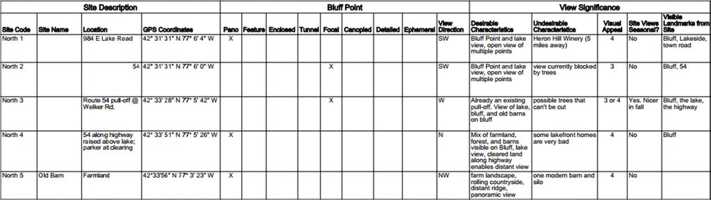
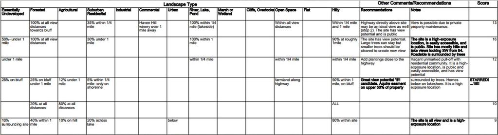
25 Methodology: Assessment The CRP 3072/5072 class drafted a site assessment survey through the analysis and reformatting of numerous other site assessment surveys provided by the professor and found through other municipal websites. The State Environmental Quality Survey and various community surveys inspired many of the questions on the site assessment survey drafted by the class (See Appendix A for full Site Assessment Survey used). The survey noted viewshed type, landscape type, traffic, activity, desirable characteristics, undesirable characteristics, and prominent features on the site or within the viewshed. Appendix A: The file above is the actual site assessment survey used for this course. A survey was filled out for each site nominated during the various field trips taken by CRP 3072/5072 throughout the Fall 2014 semester
 Site potential, 2) Desirable characteristics, and 3) Undesirable characteristics.")

26 Methodology: Site Prioritization To rank and prioritize the view sites our class identified within the watershed, we created a site prioritization ranking tool. This method awards points to viewing sites within the three categories of: 1) Site potential, 2) Desirable characteristics, and 3) Undesirable characteristics. This is by no means the only way to quantitatively rank veiwsheds but it does provide a strong starting point for prioritizing viewing sites with the most potential and desirable characteristics. Site Potential: In terms of site potential, sites with higher levels of traffic and activity were awarded more points, as well as sites along potential scenic corridors and sites already established and used by the public.

27 Methodology: Site Prioritization 2. Desirable Characteristics: All desirable characteristics mentioned on the site assessment sheets were consolidated into a single list and given a positive point value of 1, 3, or 5. Higher point values were given to attributes that cannot be replicated easily. For each site identified, points were added for all the desirable characteristics mentioned in its particular site assessment. 3. Undesirable Characteristics: Undesirable characteristics were treated similarly to their counterparts. All undesirable characteristics mentioned on the site assessment sheets were consolidated into a single list and given a negative point value of 1, 3, or 5. Lower point values were given to attributes more difficult to overcome. For each site identified, points were subtracted for all of the undesirable characteristics mentioned in its particular site assessment.
28 Methodology: Site Prioritization The following table provides a score and ranking of priority for the sites identified by our class. Scores with an additional number in parentheses () refer to a higher score that could be achieved through the purchase of development rights or through the establishment of a public site for viewing. Site Code Score Site #30 21 Site #29 20 Site #22 19 Site #5 18 Site #24 17 Site #10 16 Site #13 16 Site #3 16 Site #16 15 Site #33 14 Site #21 14 Site #1 13 Site #19 13 Site #20 13 Site #23 13 Site #4 12 Site #27 11 Site #7 10 Site #26 9 Site #9 9 Site #14 9 Site #28 8 Site #17 8 (13) Site #15 5 Site #31 4
29 Recommendations: Scenic Viewshed Plan The Finger Lakes area of New York State, like any areas within America, is blessed with many scenic areas, an abundance of natural beauty, distinctive landscapes, and historic communities that give the area its unique character. Unfortunately, despite the deep ties rural districts commonly have with the landscape and native scenery, scenic vistas and viewsheds are often extremely vulnerable and are one of the first features compromised during periods of rapid or illplanned socio economic development. In addition to the health and welfare benefits connected with scenic landscapes, they are also quite often commonly associated with other benefits, such as higher property values and increased tourism revenue. These issues are of the greatest concern to local and state government, for whom it is very important that scenic vistas and viewsheds are protected from the effects of haphazard development. While the identification of these assets is a critical first step, the next level of protection revolves around the selection of the right mix of tools to be used in a planned protection strategy. For Specific Sites Identify Potential Tools Create List of Recommended Preservation Methods For Overall Landscape
30 Recommendations: Actions for Governments The following tools have been successfully applied in various Scenic Viewshed Protection Programs across the country to regulate development and ensure the protection and management of scenic vistas and viewsheds. The final combination of methods selected for any given area should be as unique as the area to which they are being applied. Special care must be taken to ensure a thorough understanding of the benefits and potential problems associated with each tool so that the very best combination can be formulated to have maximum effect. The tools most commonly used are: Conservation Easements, purchasing target lands, easement and conservation education, the establishment of scenic byways, zoning and other development management regulations, zoning for the protection of viewsheds, and scenic conservation tax districts.


31 Recommendations: Actions for Governments Acquisition of Conservation Easements Conservation easements represent another set of tools that may be applied in the protection of scenic viewsheds. A conservation easement is a legal contract between a land owner and a government entity, qualified land trust, or conservation organization to protect natural resources. This is a completely voluntary deed restriction, through which the land owner retains ownership. However he or she cedes some control over certain aspects of the land, typically, the right to develop or subdivide the full property, which are transferred to the partner organization. Many easements take the form of tax deductible charitable donations and reduce property taxes for the landowner.
32 Recommendations: Actions for Governments Acquisition of Target Lands Land Purchase While a strategy based on purchasing parcels of land is one of the more expensive options available, in some cases certain views may be so important to the community that the outright acquisition of land may be necessary. This strategy is often facilitated through the use of land trusts. Land trusts are private nonprofit organizations operating at the local, state, or regional level that assist landowners and agencies with land preservation for the benefit of the public. They seek to protect existing open space from potentially undesirable future uses, or simply to preserve land for specific purposes, including parks, farmland, or as open space. These are organizations facilitate donations and easements. Land trusts also hold land and partial interests in land which may then be later resold to buyers who agree to specific land use restrictions.


33 Recommendations: Actions for Governments Easement and Conservation Education Several conservation easement initiatives exist in New York State and the Keuka Lake Watershed, these include Agricultural Conservation Easements, Purchase of Agricultural Conservation Easements, and Transfer of Development Rights. Education farmers and landowners about these opportunities is essential to ensuring successful conservation of agricultural land and viewshed protection. Educational sessions and materials can be updated to assist landowners with the process of obtaining easements and collaborating with regional land trusts and local governments.
34 Recommendations: Actions for Governments Zoning and other growth management Tools Zoning is one of the key tools utilized to safeguard community character and protect valued land and open space resources. Typically though, the use of zoning regulations has emphasized or even promoted urbanization and the development of land. As a result scenic viewsheds and characteristic agricultural lands have often been given relatively less priority in terms of land use. Increasingly, zoning philosophies have shifted to a point where scenic viewsheds are recognized as community assets that should be protected and embraced. This perspective s also increasingly being adopted by local communities as well who recognize their contribution to their long term viability. This support provides increased scope for utilising zoning tools in providing protection to scenic viewsheds from development pressures. Overlay Zoning Technique Overlay Zoning is used to protect neighborhoods established design character or encourage new, desired design characteristics that are not ensured by existing zoning regulations. It represents a modification of conventionally mapped zoning districts. An overlay zone may cut across several different underlying conventional zoning districts and adds (overlays) another set of regulation processes to help protect certain sensitive areas. These can include requirements such as height limits, setbacks, landscaping requirements, and screening standards in addition to those normally required by underlying zones which remain in place.


35 Recommendations: Actions for Governments While overlay zones do add another layer of review and regulation to the permitting process; when implemented correctly can introduce tremendous flexibility in effectively protecting scenic viewpoints. In addition, the concept and use of overlay zones are familiar to planning staff, developers, and residents, making them generally publicly and politically acceptable. Steep Slope Overlay Districts are a similar concept, representing a special zone created over areas with steep slope. The overlay requirements do not replace the underlying zoning district regulations, but are in addition to them. A steep slope requirement would regulate development on areas with slopes greater than a specified percentage, usually in the 10 15% range. These are particularly useful in directly benefit the water quality of a watershed by imposing additional restrictions on the type of land use allowed.

 and conservation subdivision design (below right).")
36 Recommendations: Actions for Governments Cluster Subdivision Cluster Subdivisions aim to create interconnected networks of protected lands as development occurs, ensuring conservation of contiguous tracts of open space and scenic resources at little or no public cost. They are specifically designed around the most significant natural resources of each site, and the economic marketability of the community to add value to benefit both the environment and economy of the community. Comparison: Conventional subdivision (below left) and conservation subdivision design (below right). The preferred approach on the right illustrates a conservation subdivision design that provides an optimum balance between working landscape, scenic corridor, and viewsheds of individual homes. Houses are usually sited on smaller parcels of land, while the additional previously used land is allocated to shared open space for the subdivision residents. Typically, lot size, setbacks, and other traditional subdivision regulations are allocated to ecologically sensitive areas, historical sites, or other unique characteristics of the land being subdivided.
37 Recommendations: Actions for Governments Scenic Byways Designation The use of Scenic viewshed corridors and byways are extremely useful tools in showcasing the landscape and community character which are most viewed by motorists, particularly visitors and tourists. In addition to highlighting a great landscapes or vistas alongside roadways, scenic corridors are effective barriers for such features against inappropriate future development; as such they have a very important dual function. Scenic byway designation is a program (state and federal) that awards special status to roads with special scenic, recreational, cultural, natural, historic, or archeological significance. To qualify as a scenic byway in New York state, a route must receive special designation by the state legislature or some other official declaration. There are a number of benefits to obtaining scenic byway designation: NY State offers grants for infrastructure improvements, marketing efforts, and economic development activities. In addition, scenic byways receive funding to install consistent signage advertising byway status, and are included in statewide scenic byway marketing efforts. While the designation process is lengthy and depends on significant successful volunteer effort the benefits once acquired are many. For municipalities along byway routes, the byway designation is often associated with increased levels of tourism, the subsequent revenue and economic development. Once again this type of program relies heavily on successful intra municipality cooperation.
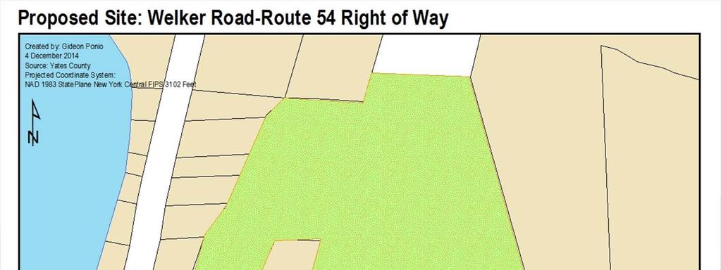
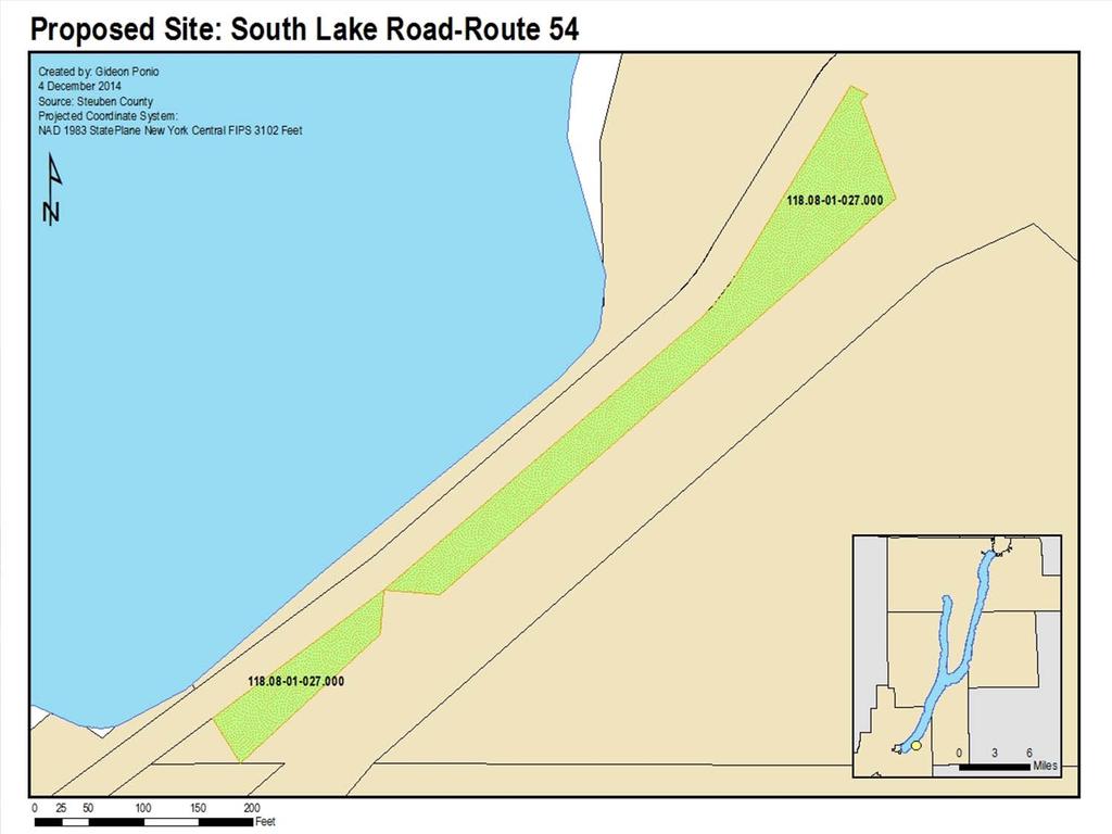
38 Recommendations: Actions for Governments Specific Scenic Corridors to be Considered for Nomination as Scenic Byways Given its focal point, the most obvious nominations for scenic byways as a recommended strategy under the Keuka Lake Scenic Resources Protection Plan would naturally be of New York State Routes 54 (NY 54) and 54A (NY 54A). Both of these run parallel to Lake Keuka, offering spectacular panoramic and closer views of Bluff Point and the rest of the lake along their entire length. NY 54 serves as the eastern lakeside road along Keuka Lake, while NY 54A, NY 54's alternate route between Hammondsport and Penn Yan, runs along the western and northern lakeshore. Route 76 (South Pulteney Road), as well as Routes 78/75 should also be considered for nomination as Scenic Byways. Their elevation provides access to the characteristic panoramic views of the southern portion of Keuka Lake, and the many wineries also located on that side. In addition to offering spectacular views do to their strategic locations, these routes, particularly NY 54 and 54A can support high enough traffic flows to support their nominations. In addition, the raised profile and publicity that is traditionally associated with national Scenic Byways would serve to positively complement tourism activity in the area. However, one major advantage of having alternates routes nominated is the ability to more effectively manage any increased traffic which may be realized. In addition, the nomination of both Routes in tandem would offer an additional layer of protection to Keuka Lake on both its sides.


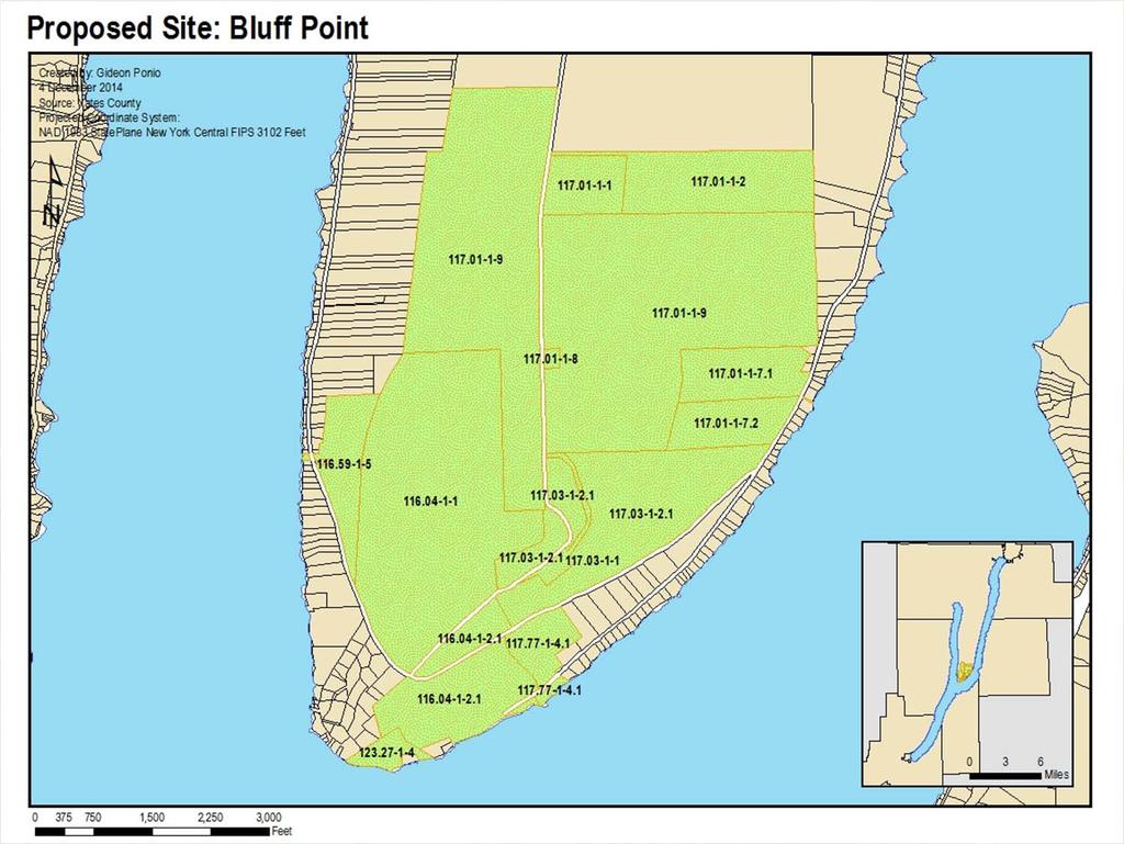
39 Recommendations: Actions for Governments Nominations As stated earlier, the Keuka Lake watershed has a variety of scenic viewpoints along the several routes that hug the shoreline and sloped hillsides of the region. Listed below are five locations unique to the Keuka Lake s scenic views and rich history, and several of these locations act as viewpoints that enhance the view of Keuka Lake s most notable landmark: Bluff Point 1. Garrett Memorial Chapel 2. Bully Hill Winery 3. Heron Hill Winery 4. Red Jacket Memorial 5. Glen H. Curtiss Museum


40 Recommendations: Actions for Governments Nominations Garrett Memorial Church: Coordinates: N 42 degrees minutes E 77 degrees minutes This historical church has endured in the watershed for over 100 years. The church has a unique family history that is rarely found today amongst modern churches throughout the United States. The structural elements of the church are reminiscent of medieval architecture and provide a historical experience that is all but uncommon in upstate New York.


41 Recommendations: Actions for Governments Nominations Bully Hill Winery: Coordinates: N 42 degrees 25 minutes W 77 degrees 12 minutes Bully Hill Winery, a century old winery located in the southwestern corner of Keuka Lake, has proved to be a main tourist attraction to the region for many years. The grapes, which are grown entirely throughout the watershed, provide for a company that guarantees its consumer a local experience with every bottle. The winery overlooks the viewshed and creates a scenic view of the lake surrounded by the steep, sloping hills and wooded landscapes. This scenic view is attractive throughout the four seasons.


42 Recommendations: Actions for Governments Nominations Heron Hill Winery: Coordinates: N 42 degrees 26 minutes W 77 degrees 12 minutes 6.13 This is a 35 year old winery. It is also the destination of more than 50,000 visitors every year. It is located off of Route 54A along the lakeside. Travelers can see scenic hilltop view of the Keuka Lake region with every visit. There is consistent traffic on the road on a day to day basis that guarantees the potential for this site. It is not uncommon for the occasional visitor to stop and take a photograph of the landsacpe in admiration


43 Recommendations: Actions for Governments Nominations Red Jacket Memorial: Coordinates: N 42 degrees 35 minutes W 77 degrees 9 minutes 3.49 One unique aspect of the Keuka Lake viewshed is the extent to which it preserves Native American history. Red Jacket was a Seneca Native American, as well as chief of the Wolf Clan. He was famously known for handling negotiations between Native Americans and the colonist. His work was so highly admirable that he was presented the Peace Medal by president George Washington for his efforts in maintaining peace. This particular location is the site of his mother s grave. Mothers are predominant figures in the Native American culture that give power, which makes the sight both a cultural and historical site with much importance to the region.


44 Recommendations: Actions for Governments Nominations Glenn H. Curtiss Museum: Coordinates: N 42 degrees 25 minutes W 77 degrees 12 minutes Glenn H. Curtiss Museum is an important landmark to Glenn Curtiss who contributed greatly to aviation industry in United States. He was the first US army flight engineer, and he also won the first international air speed record. He is known as the founder of the modern aviation industry.
45 Recommendations: Actions for Individuals There are numerous steps that individuals can take to begin protecting the natural character of their area s landscape. While the majority of these are more successful when implemented on a large scale, every action makes a difference and it is crucial to realize the importance that every individual plays in protecting the scenic quality of the Keuka Lake Watershed. Whether homeowner, business owner, vintner, or farmer, there are numerous steps that can be taken at a variety of different scales. The primary tools for individual landowners are: Establish Conservation Easements Conduct Visual Property Assessments Conduct Site Plan Reviews Match new building designs to existing local character Mitigate visual impact of new and existing structures Protect the integrity of the existing landscape
46 Recommendations: Actions for Individuals Mitigate Visual Impact of Development, Buildings, and Improvements Site development below visual buffers such as trees, ridgelines, and other natural topographic features so as to not alter the views of and from the ridgeline. Structures should be sited at lower elevations so that they do not exceed the treeline of hillsides and ridges Incorporate significant landscape features into new side designs. Situate large, bright, or highly reflective buildings behind existing vegetation so that the top of the building does not extend above the tree line when viewed from primary public areas and corridors Maintain disturbance free areas with existing trees and vegetation to screen buildings when viewed from protected or highly public areas. Supplement and care for existing vegetation in protected areas to enhance screening and mitigate visual impacts


47 Recommendations: Actions for Individuals Mitigate Visual Impact of Development, Buildings, and Improvements In areas where no sizable area of protection exists, establish landscaped buffers of indigenous deciduous and coniferous trees to permanently screen development from view Building and structure heights should be limited to 30 Buildings should be oriented to preserve the view line from any public area, view, or way Cleared areas should be screened from view of other areas by an area of protection or wall of shrubbery Use earth tones and low reflective materials on roofing and siding to maintain the integrity of valued viewsheds Rooflines should be varied to provide visual interest and minimize the scale of the building.
48 Recommendations: Actions for Individuals Maintain Integrity of Natural Landscape All new plantings should be native, indigenous species Deciduous trees should be no smaller than 2 in diameter at the time of planting, coniferous trees should be no less than 6 10 feet in height at the time of planting, and understory shrubs should be a minimum of four feet in height at the time of planting Maintain low level existing vegetation adjacent to roadways when wooded areas are developed


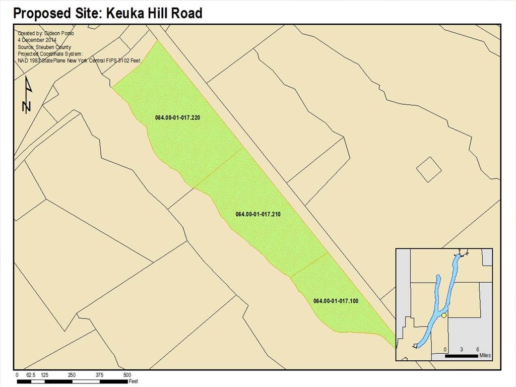
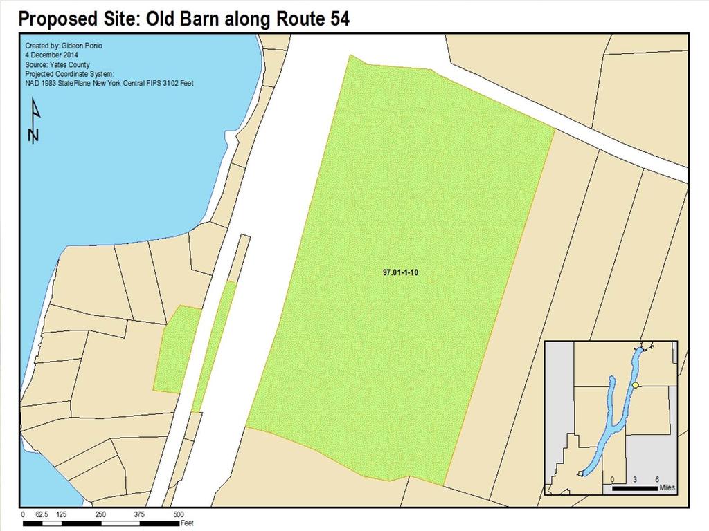
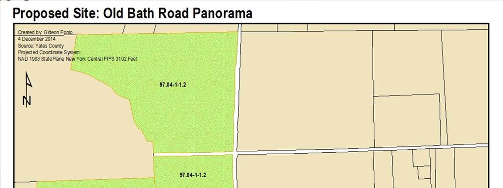
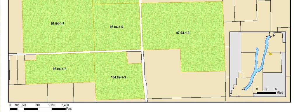
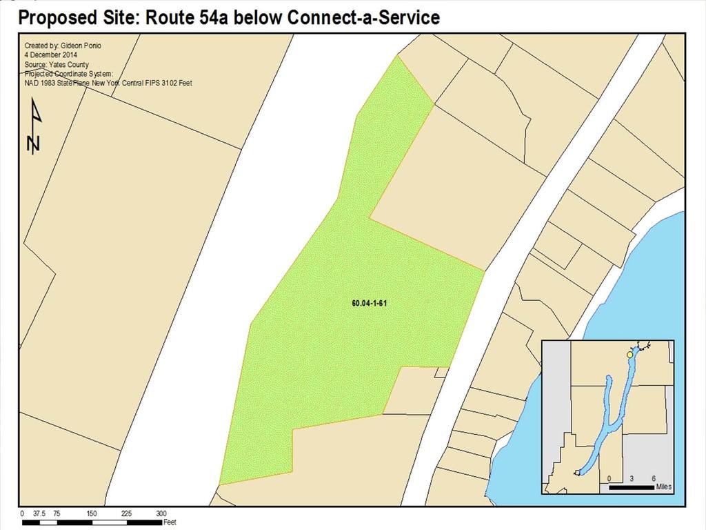
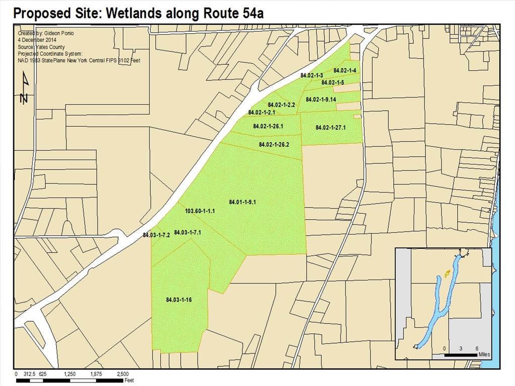
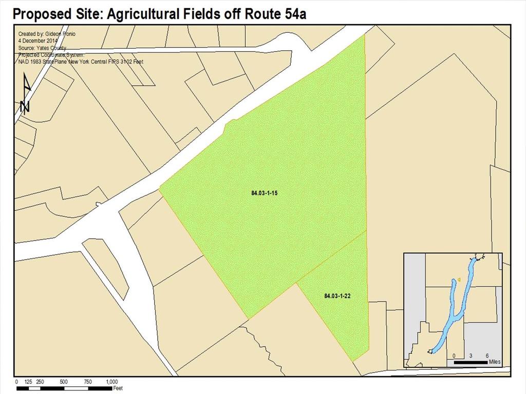
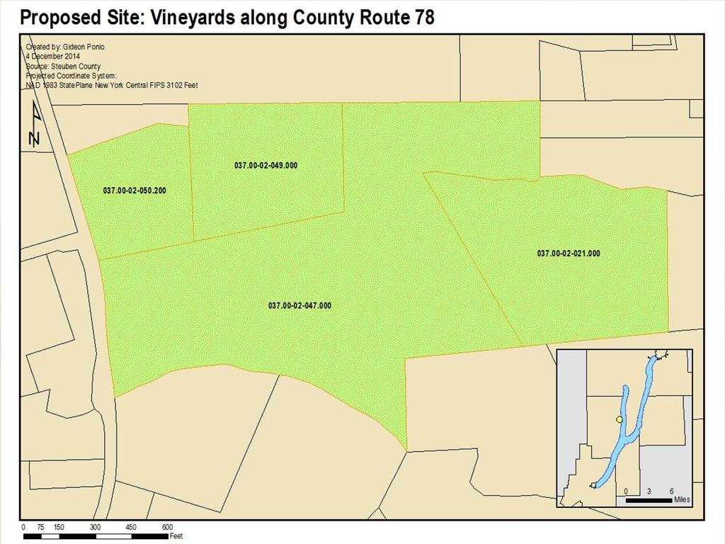
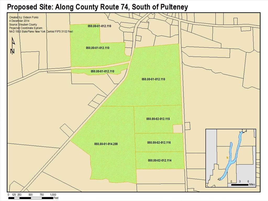
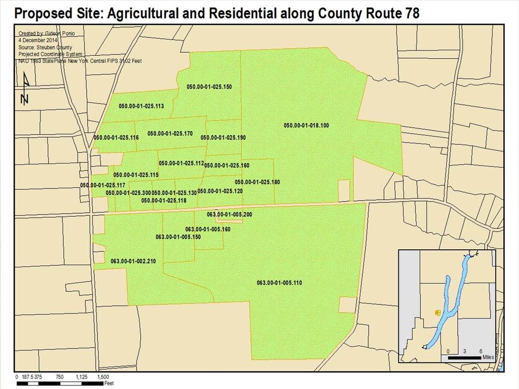
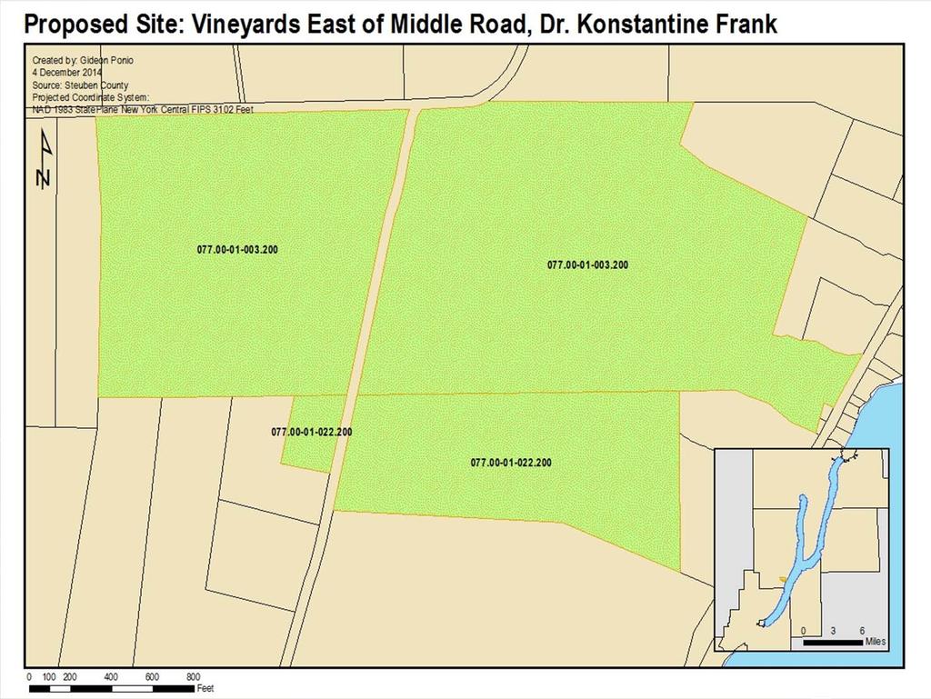
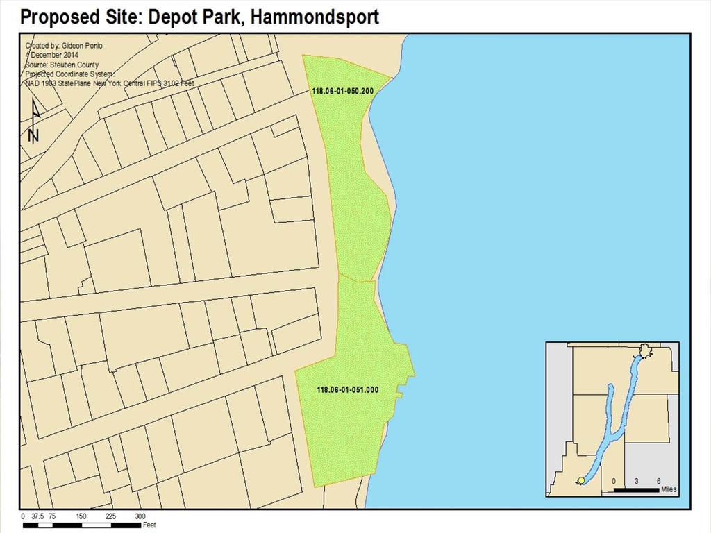
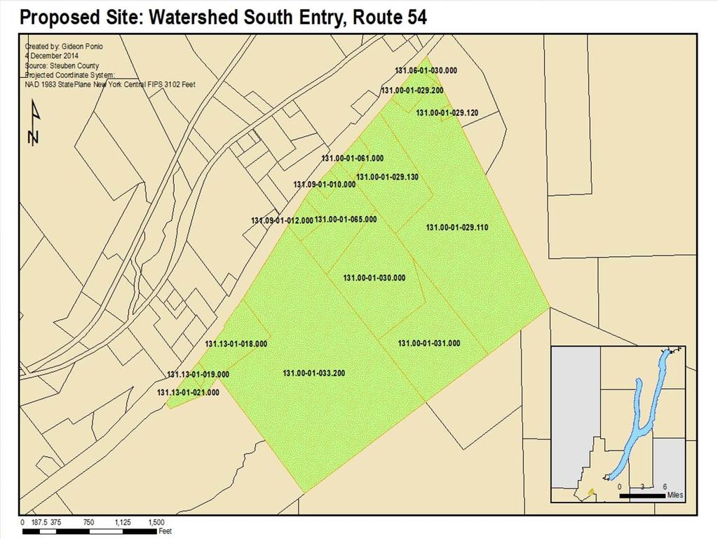
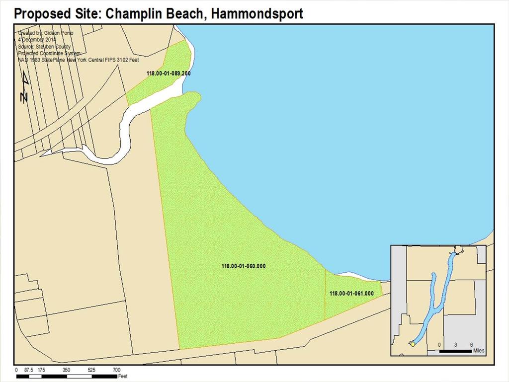
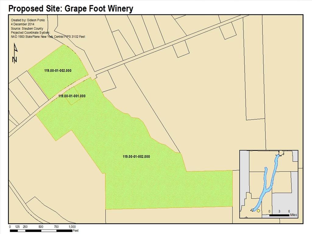
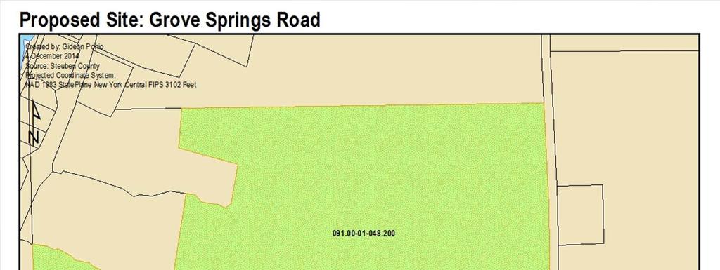
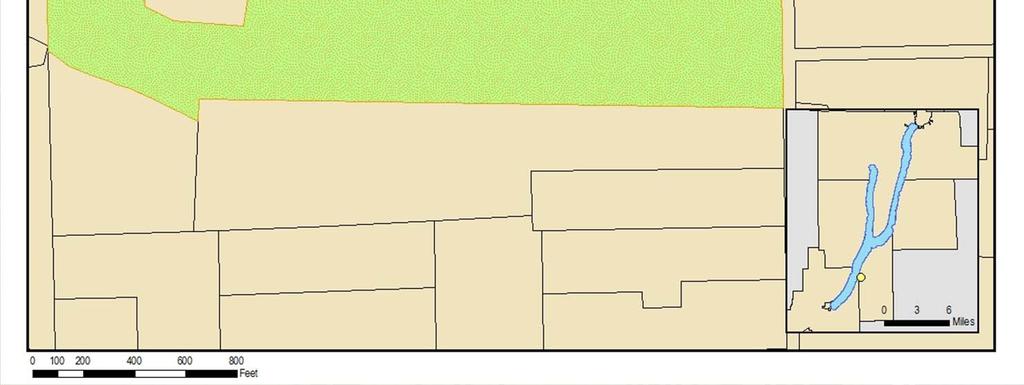
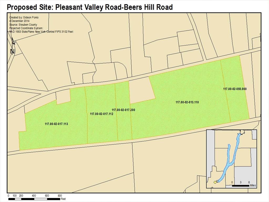
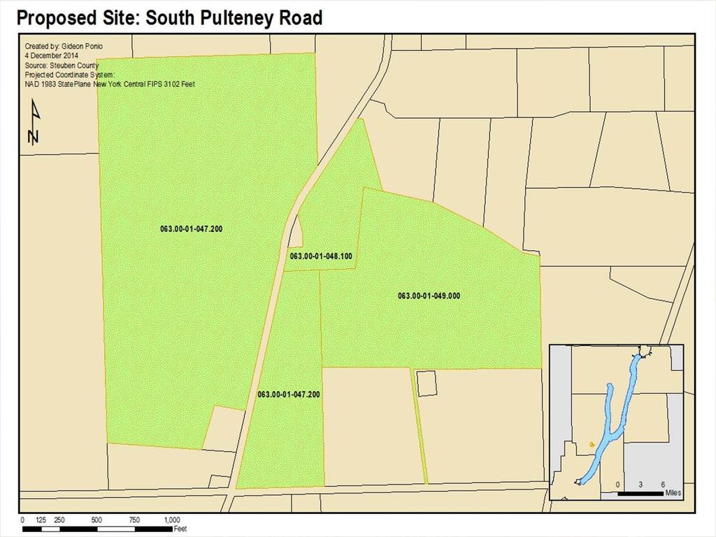
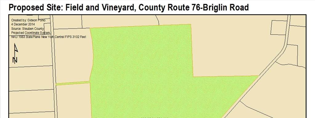
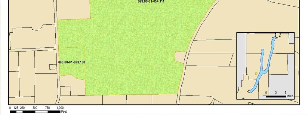
49 Recommendations: Sites for Protection We have identified 34 different sites in the Keuka Lake Watershed that significantly contribute to the scenic quality and enjoyment of the area. These sites, primarily located along major highways, should be addressed, enhanced, and improved in order to strengthen the visual quality of the watershed and support its existing appreciation for the region s natural beauty

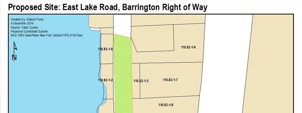
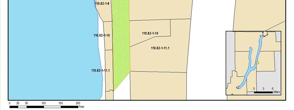
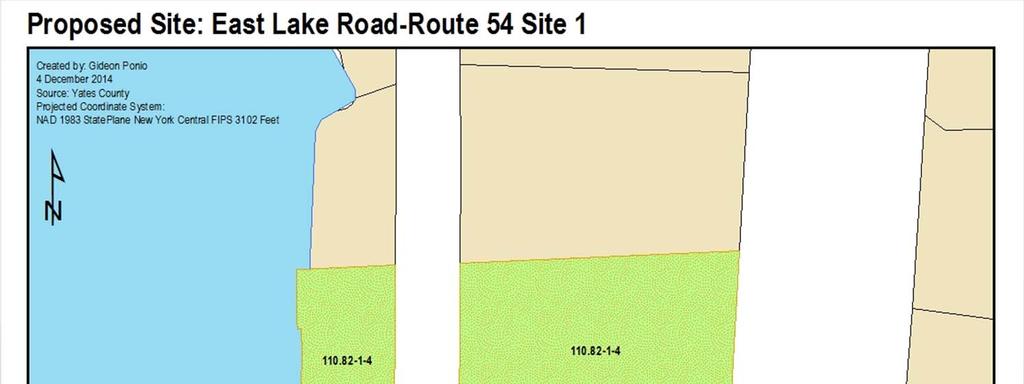
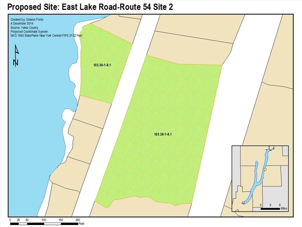
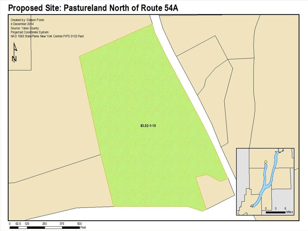
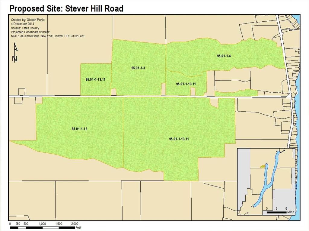
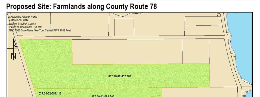
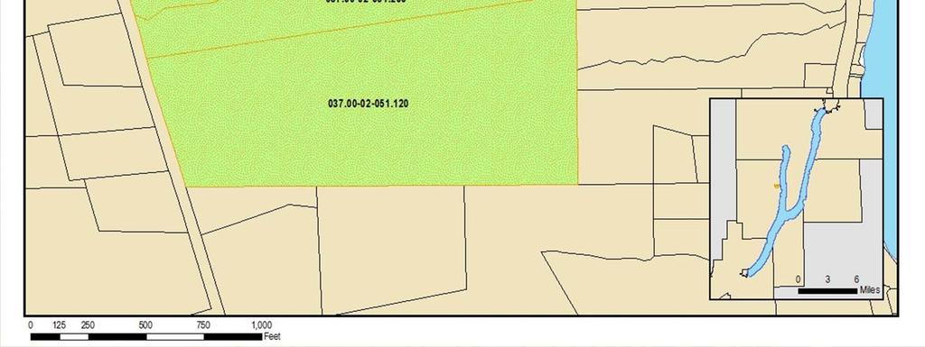
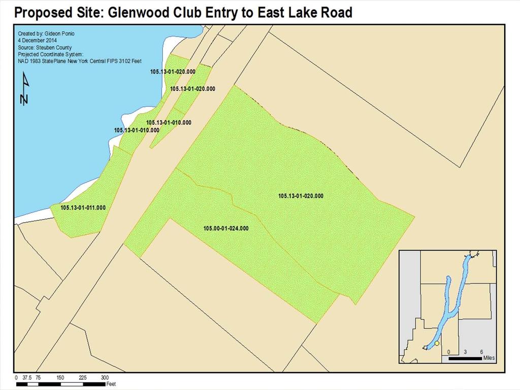
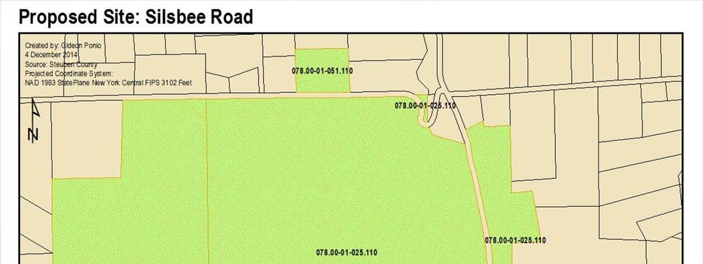
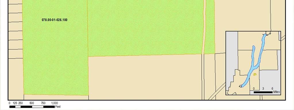
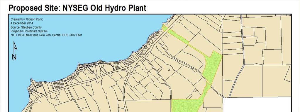
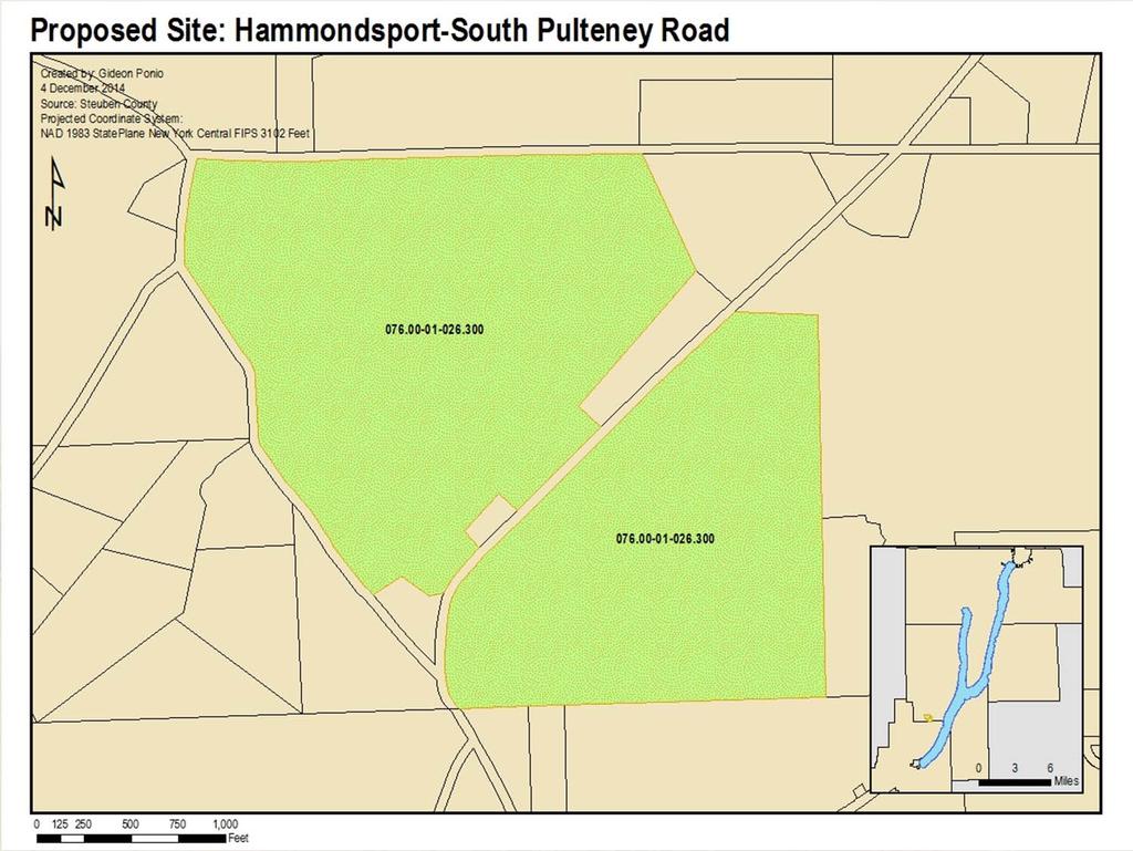
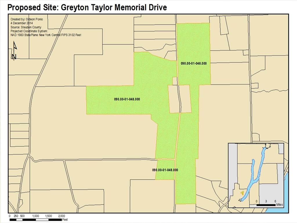
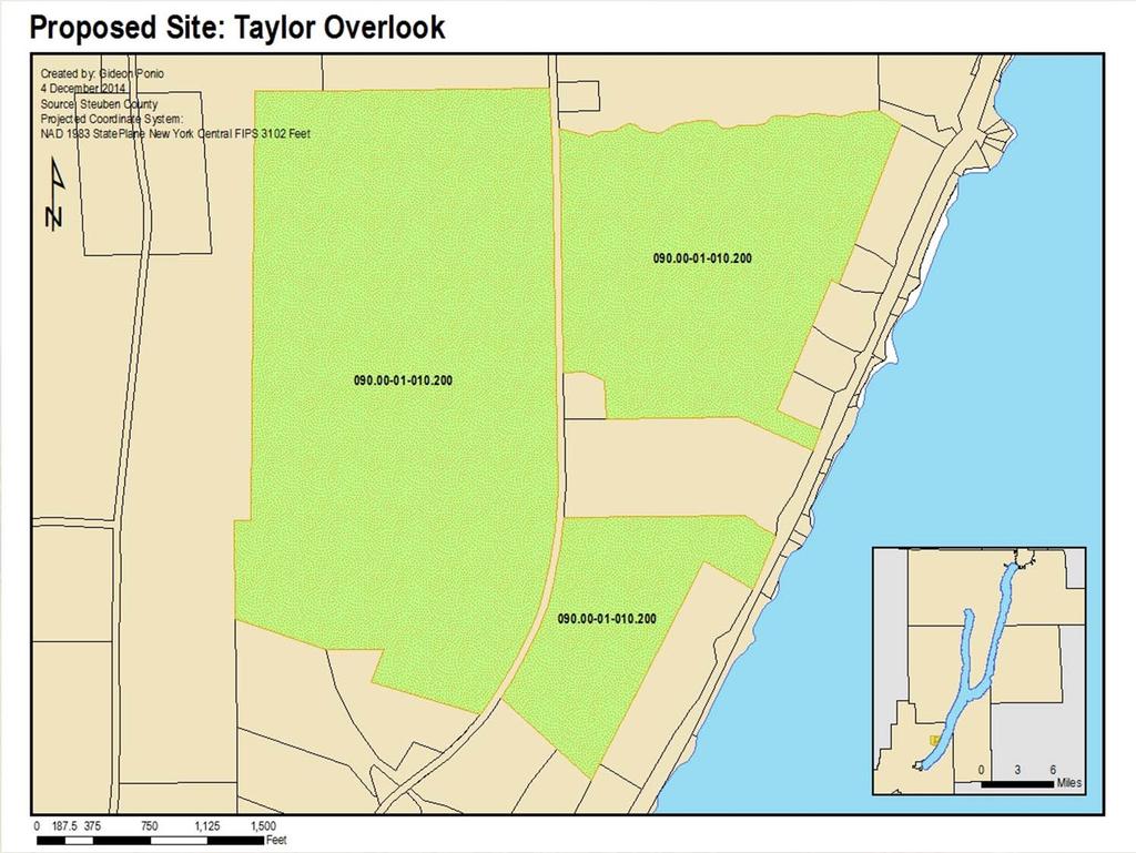
50 Site 1

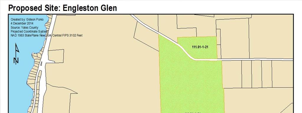
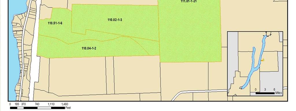
51 Site 2

52 Site 3

53 Site 4

54 Site 5

55 Site 6

56 Site 7

57 Site 8

58 Site 9

59 Site 10

60 Site 11

61 Site 12

62 Site 13

63 Site 14

64 Site 15

65 Site 16

66 Site 17

67 Site 18

68 Site 19

69 Site 20

70 Site 21

71 Site 22

72 Site 23

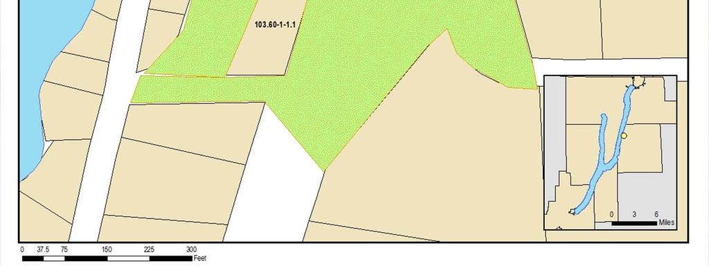
73 Site 24

74 Site 25

75 Site 26

76 Site 27

77 Site 28

78 Site 29

79 Site 30

80 Site 31

81 Site 32

82 Site 33

83 Site 34

84 Appendix: Site Assessment Sheet

85 Appendix: Site Assessment Sheet

86 Appendix: Site Matrix

87 References The Ancestors of the Iroquois. Native American Netroots. The Human History Around Keuka Lake. Keuka Lake Association People: The Universal Friend. Yates County.org. Genesee/Finger Lakes Regional Planning Council, Keuka Lake Watershed Land Use Planning Guide, 2009, pg. 8 9 Comprehensive Plan of the Town of Barrington, 2009, pg. 16 Geology of the Keuka Lake: Bedrock Geology Keuka Lake Association. Keuka Lake Watershed Land Use Planning Guide, Genesee/Finger Lakes Regional Planning Council, 2009
Sustainable Keuka Lake
 Sustainable Keuka Lake Steve Butchko, Town of Wayne Supervisor Chelsea Robertson, Senior Planner STC Kemberli Sargent, Planner STC www.sustainablekeuka.net This presentation was prepared for the New York
Town of Peru Comprehensive Plan Executive Summary
 Town of Peru Comprehensive Plan Executive Communities that plan grow by choice, not by chance. A plan makes growth thoughtful, understandable, and predictable. A plan shows that a community is managing
I. STAFF POLICY RECOMMENDATIONS. The following RMP policy strategies are proposed by staff in support of a Scenic Resource Protection Program:
 Policy Consideration: Scenic Resource Protection Program Status: For Consideration by the Highlands Council at September 14, 2006 Work session Date: September 12, 2006 I. STAFF POLICY RECOMMENDATIONS The
Protecting Scenic Views
 The Genesee-Finger Lakes Region is distinguished by roadway corridors and locations from which outstanding scenic views can be appreciated. Our special views encompass agricultural lands, natural areas,
This page intentionally blank.
 This page intentionally blank. Parks, Recreation, and Open Space Chapter Relationship to Vision Vision Parks, Recreation and Open Space Chapter Concepts County Government. County government that is accountable
Preface. Erie. Scranton. Allentown. Pittsburgh. Harrisburg. Philadelphia
 The Southern Alleghenies Region The Southern Alleghenies Region spans the Laurel Highlands and Allegheny Front in the west across the Appalachians to the east. It is comprised of Blair, Bedford, Cambria,
TABLE OF CONTENTS. Transportation Chapter 1 - Introduction and Purpose of Planning to 1-3. Utilities
 Chapter 1 - Introduction and Purpose of Planning... 1-1 to 1-3 Pennsylvania Municipalities Planning Code (Act 247)...1-1 Previous County Planning Activities...1-1 Objectives of the Plan...1-2 Elements
WATERFORD Plan of Preservation, Conservation and Development Supplement Part 1 - Policy Element
 WATERFORD 2012 Plan of Preservation, Conservation and Development 2015 Supplement Part 1 - Policy Element Effective June 11, 2015 2015 Plan Update GOAL To respond to the evolving land use needs and continually
10.0 Open Space and Public Realm
 10.0 Open Space and Public Realm 10.0 Open Space and Public Realm The Public Open Space System is comprised of: outdoor spaces available for public use that are either publicly owned (e.g., parks and
3. VISION AND GOALS. Vision Statement. Goals, Objectives and Policies
 Vision Statement Queen Creek s interconnected network of parks, trails, open spaces and recreation opportunities provide safe and diverse activities and programs that sustain its unique, small town, equestrian
Municipal Comprehensive and Open Space Plans
 Appendix 13-A Local Historic Policy Municipal Comprehensive and Open Space Plans Oxford Regional Comprehensive Plan (1969) The Oxford Regional Comprehensive Plan serves as the Comprehensive Plan for Oxford
CHAPTER 4 FUTURE LAND USE AND URBAN SERVICES DISTRICTS
 CHAPTER 4 FUTURE LAND USE AND URBAN SERVICES DISTRICTS Introduction This chapter discusses how Benzie County should grow and change in the future. A community can grow and change in many different ways.
{Best Practices. Summary of Tools, Strategies and Best Practices from 11 Michigan Case Study Communities
 Case Studies Michigan Coastal Community Working Waterfronts { Summary of Tools, Strategies and from 11 Michigan Case Study Communities Table of Contents Zoning...2 Community and Stakeholder Collaboration
TOWN OF SPRINGFIELD, NEW HAMPSHIRE
 TOWN OF SPRINGFIELD, NEW HAMPSHIRE NATURAL RESOURCES INVENTORY EXECUTIVE SUMMARY March 2008 Prepared by: Watershed to Wildlife, Inc. Natural Resource Consultants 42 Mill Street, Suite 3 Littleton, NH 03561
Green Infrastructure Policies and Ordinances
 Green Infrastructure Policies and Ordinances October 23, 2013 By Karen Firehock, Green Infrastructure Center 2013 Georgia Urban Forest Council s 23 rd Annual Conference The mission of the nonprofit Green
Comprehensive Plan ADOPTED APRIL 2014
 Comprehensive Plan ADOPTED APRIL 2014 8 8. Outstanding Recreational & Cultural Opportunities We are proud of our community s parks and recreation system. Our community will ensure that the legacy of our
Gloucester County s Comprehensive Plan. The Community Connection
 Gloucester County s Comprehensive Plan The Community Connection Current Comp Plan Adopted in 1991 with a 20 year planning horizon Updated in 1995 with Part V- Implementation Recommendations and Appendix
RECREATION, OPEN SPACE AND GREENWAYS ELEMENT GOALS, OBJECTIVES, AND POLICIES
 RECREATION, OPEN SPACE AND GREENWAYS ELEMENT GOALS, OBJECTIVES, AND POLICIES GOAL R-1: DEVELOP A RECREATION, OPEN SPACE AND GREENWAYS SYSTEM AS AN INTEGRAL COMPONENT OF AN OVERALL, COUNTY-WIDE ECONOMIC
RECREATION AND OPEN SPACE ELEMENT GOALS, OBJECTIVES, AND POLICIES
 RECREATION AND OPEN SPACE ELEMENT GOALS, OBJECTIVES, AND POLICIES Goal 7 To provide park facilities, recreation programs, and open space resources that are safe, adequate, and accessible to all City residents,
3.10 LAND USE SETTING PROJECT SITE EXISTING LAND USE DESIGNATIONS AND ZONING. General Plan Land Use Designations.
 This section of the Draft EIR addresses the existing land uses on and adjacent to the project site and discusses the potential impacts of the proposed project on existing land uses. Key issues addressed
Port Lavaca Future Land Use
 Port Lavaca Future Land Use Introduction The City of Port Lavaca is beginning to see sustained growth, after many years of relative stable population. New single family homes, apartments, and businesses
Member Service Plan Sierra Nevada AmeriCorps Partnership
 Member Service Plan Sierra Nevada AmeriCorps Partnership Service plans lay the framework for what each Member will be doing during their service. Service plans detail the major projects and expected results
RIDGES TO RIVERS OPEN SPACE NETWORI< OF THE MID-COLUMBIA DRAFT ACTION PLAN
 RIDGES TO RIVERS OPEN SPACE NETWORI< OF THE MID-COLUMBIA DRAFT ACTION PLAN Ridges to Rivers Open Space Network of the Mid-Columbia Region Draft Action Plan (8/6/08) The goals of the propose
COMMUNITY DESIGN. GOAL: Create livable and attractive communities. Intent
 COMMUNITY DESIGN Intent An attractive, well-designed County will attract quality development, instill civic pride, improve the visual character of the community, and create a strong, positive image for
2.0 AREA PLANS. Lakeside Business District. Lakeside Business District Land Use Categories:
 Lakeside Business District Lakeside Business District Land Use Categories: Campus Commercial Campus Commercial means a mixture of uses which includes corporate offices, office parks, hotels, commercial,
Chapter 10 IMPLEMENTATION RECOMMENDATIONS
 Chapter 10 IMPLEMENTATION RECOMMENDATIONS The recommended land use plan presented in the previous chapter provides a design for the attainment of the urban and rural development and open space preservation
Central Lake Ontario Conservation Conservation Lands Master Plan
 Conservation Lands Master Plan Top 13 Frequently Asked Questions 1. What are conservation lands? Where are these conservation lands located in the Central Lake Ontario Conservation watershed? Conservation
Chapter 6: Community Character
 Chapter 6: Community Character The term "community character" covers a broad spectrum of concerns. First and foremost, community character is a visual concept. In Long Grove, however, community character
Chapter 5: Recreation
 Chapter 5: Recreation Introduction and Setting Recreational opportunities within Nevada County are varied, ranging from public parks with intensively used active recreational facilities, to vast tracts
THREE-STEP DESIGN PROCESS FOR OPEN SPACE SUBDIVISIONS
 00216106.DOC NMA/RRK 1/30/14 THREE-STEP DESIGN PROCESS FOR OPEN SPACE SUBDIVISIONS Open space subdivisions, sometimes called cluster developments, maintain a significant portion of a development site in
Arlington, Virginia is a worldclass
 EXECUTIVE S U M M A RY Arlington maintains a rich variety of stable neighborhoods, quality schools and enlightened land use policies, and received the Environmental Protection Agency s highest award for
OPEN SPACE CHAPTER 7: OVERVIEW. Preserve open space to protect natural resources, enhance character and provide passive recreation opportunities
 CHAPTER 7: OPEN SPACE OVERVIEW Ridgefield has made tremendous progress permanently preserving areas of town as open space. Open space preservation can serve many important purposes, including: protect
Growth Management: Common Value 2 of Community Character
 Growth Management: Common Value 2 of Community Character 24 Why is Growth Management a Common Value? Effective Growth Management is essential to protecting our surrounding ecosystem and reinforcing our
Genesee/Finger Lakes Regional Planning Council (G/FLRPC) February Webinar Series. Regional Planning Councils. G/FLRPC - February 10, 2016, 12:00-1:00
 February Webinar Series. Regional Planning Councils. G/FLRPC - February 10, 2016, 12:00-1:00") Genesee/Finger Lakes Regional Planning Council (G/FLRPC) February Webinar Series G/FLRPC - February 10, 2016, 12:00-1:00 Exploring Census Data Tools - February 17, 2016, 12:00-1:00 Economic Development
Genesee/Finger Lakes Regional Planning Council (G/FLRPC) February Webinar Series G/FLRPC - February 10, 2016, 12:00-1:00 Exploring Census Data Tools - February 17, 2016, 12:00-1:00 Economic Development
TRANSPORTATION AND LAND USE
 CHAPTER 10 TRANSPORTATION AND LAND USE Transportation and land use are intimately linked. The expansion of a highway typically spurs housing, employment growth and land development in the communities that
Laberge Group. Town of Coeymans. Draft Comprehensive Plan. Overview of Planning Process
 Draft : Presentation of Goals & Strategies Laberge Group Benjamin H. Syden, A.I.C.P., E.D.P Director in Charge Nicole Allen, A.I.C.P. Senior Planner Anjali Malhotra Planner Presentation Outline Introductions
Yadkin River Greenway Feasibility Study Fact Sheet Village of Clemmons, Town of Lewisville, Town of Bermuda Run
 Fact Sheet Village of Clemmons, Town of Lewisville, Town of Bermuda Run Project Background The Yadkin River Greenway Feasibility Study is a joint project with the Village of Clemmons, the Town of Bermuda
Sorted citizen input comments in review of Blount County plans July, August, and September 2007
 Sorted citizen input comments in review of Blount County plans July, August, and September 2007 The following presents sorted citizen input comments from three sessions held in July, August and September
The transportation system in a community is an
 7 TRANSPORTATION The transportation system in a community is an important factor contributing to the quality of life of the residents. Without a sound transportation system to bring both goods and patrons
Lake O the Pines Master Plan Revision Public Information Meeting April 25 & 27, 2017
 Lake O the Pines Master Plan Revision Public Information Meeting April 25 & 27, 2017 Presented By Matthew Like, Lake Manager U.S. Army Corps of Engineers Fort Worth District US Army Corps of Engineers
9 th Street Sub Area Plan
 9 th Street Sub Area Plan In the 1990 s, when the Township prepared the last Master Plan, the 9 th Street corridor was studied as part of a larger 9 th Street Focus Area that included the West Main Street
Goals and Objectives Survey December 4, 2013
 Goals and Objectives Survey December 4, 2013 Process The 2006 Master Plan was based upon a set of 12 goals with various objectives tied to each goal. Goals = High level aspirations that provide general
SUSSEX COUNTY COMPREHENSIVE PLAN COUNTY PLANNING AND ZONING COMMISSION WORKSHOP
 SUSSEX COUNTY COMPREHENSIVE PLAN COUNTY PLANNING AND ZONING COMMISSION WORKSHOP August 21, 2017 TODAY S WORKSHOP Public Comment Utilities Update Economic Development Update Future Land Use Discussion Public
37 Interlaken A Vision To The Future
 37 Interlaken A Vision To The Future The History The Beckwith or Bonnie Briar Estate is one of the original Berkshires Cottages. It was built in 1892 and designed by architect and wealthy owner Leonard
Planning for and Managing Open Space and Natural Areas
 Planning for and Managing Open Space and Natural Areas Increasingly, development proposals in Delaware include large amounts of open space and natural areas. While open space is important as a community
Objectives and Strategies for the Integration of Recreation, Parks and Open Space in Regional Plans
 BULLETIN 2 Objectives and Strategies for the Integration of Recreation, Parks and Open Space in Regional Plans TABLE OF CONTENTS Introduction 3 Land-use Framework Outcomes 1 4-8 Land-use Framework Outcomes
Community Conservation Workshop. Saranac River Basin Communities
 Community Conservation Workshop Saranac River Basin Communities 2 Community Conservation Program Welcome! We have designed a Community Conservation Program that listens to the needs of community members.
STEWARDSHIP OF LONG ISLAND SOUND S ECOLOGICAL AND RECREATIONAL RESOURCES
 STEWARDSHIP OF LONG ISLAND SOUND S ECOLOGICAL AND RECREATIONAL RESOURCES Robin Kriesberg, Save the Sound, Inc. Thomas Halavik, US Fish and Wildlife Service Coastal Program An Initiative to Identify, Protect
Cotswolds AONB Landscape Strategy and Guidelines. June 2016
 Cotswolds AONB Landscape Strategy and Guidelines June 2016 Cotswolds AONB Landscape Strategy and Guidelines Introduction The evolution of the landscape of the Cotswolds AONB is a result of the interaction
Community Conservation Workshop. Lake Placid
 Community Conservation Workshop Lake Placid 2 Community Conservation Program Welcome! We have designed a Community Conservation Program that listens to the needs of community members. We are conducting
CHAPTER 4.1 COMMUNITY HERITAGE AND HISTORIC PRESERVATION ELEMENT
 CHAPTER 4.1 COMMUNITY HERITAGE AND HISTORIC PRESERVATION ELEMENT Vision: Retention of the community s heritage and atmosphere through identification, preservation and ongoing support of important traditions,
FOSTER COMPREHENSIVE PLAN UPDATE CIRCULATION
 5.8.1 INTRODUCTION CIRCULATION The Circulation Element of the Comprehensive Plan studies the routes and modes of travel. The circulation network of the town affects the ease of movement through Foster
RURAL ZONE - POLICY. Rural Zone Policy. Issue: Rural Environment. Ruapehu District Plan Page 1 of 8
 Rural Zone Policy RU2 RURAL ZONE - POLICY RU2.1 Introduction The natural resources of the rural environment in the Ruapehu District provide the basis for the existing and potential character, intensity
PRINCIPLE 6: Preserve open space, farmland, natural beauty, and critical environmental areas
 HOW TO APPLY SMART GROWTH PRINCIPLES TO RURAL COMMUNITIES PRINCIPLE 6: Preserve open space, farmland, natural beauty, and critical environmental areas A product of AND A cooperative publication from the
The following principles guide the development of goals and strategies to protect and promote these amenities:
 OPEN SPACE/PARKS/TRAILS/RECREATION GOALS/STRATEGIES Cherry Hills Village is a living environment that offers low density development, open areas, public scenic vistas, public trails and public parks. This
1.0 Circulation Element
 5/9/18 1.0 Circulation Element 1.1 Introduction As growth and development occur in Apache County, enhancements to its circulation system will be necessary. With time, more roads will be paved and air and
Introducing the Main Street Strategic Toolbox
 Ulster County Main Streets: A Regional Approach Ulster County Planning Department, 244 Fair Street, Kingston NY 12401 Why do we take a regional approach to Main Streets? There are many different approaches
Conservation Corridor Planning and Green Infrastructure Themes
 Conservation Corridor Planning and Green Infrastructure Themes Prepared by the Green Infrastructure Center Inc. and the Northern Virginia Regional Commission February 22, 2011 Brief Overview Project Background
Please read the entire document
 projects impacting the waterfront revitalization area. The waterfront revitalization area of the town will have to subareas to the west and east of the village. Page 6 of 6 Wayfinding master plan create
Statewide Greenways Vision
 Greenways Vision The formation of a greenways vision is based on a thorough analysis of the current state of recreation and open space in a region and the existing pressures that threaten it. Lehigh and
IV. Development in the Rural Overlay District
 Intracoastal Waterway Route 17 Route 168 Great Dismal Swamp VIRGINIA NORTH CAROLINA IV. Development in the Rural Overlay District IV-1 Route 17 in Chesapeake s Rural Overlay District affords distant views
Summary of Action Strategies
 Strategic Action Plan 6 Summary of Action Strategies Action Strategy Categories: 1. Organization and Management 2. Implementation 3. Marketing and Promotion This chapter summarizes all of the action strategies
TERRESTRIAL NATURAL HERITAGE SYSTEM STRATEGY APPENDIX F: MODEL POLICIES FOR THE IMPLEMENTATION OF THE TARGET TERRESTRIAL NATURAL HERITAGE SYSTEM
 TERRESTRIAL NATURAL HERITAGE SYSTEM STRATEGY APPENDIX F: MODEL POLICIES FOR THE IMPLEMENTATION OF THE TARGET TERRESTRIAL NATURAL HERITAGE SYSTEM C H A P T E R 1 M O D E L P O L I C I E S F O R I M P L
EXECUTIVE SUMMARY DRAFT CHAPTER 1 INTRODUCTION EXECUTIVE SUMMARY
 CHAPTER 1 EXECUTIVE SUMMARY INTRODUCTION Through the joint efforts of the City of Tulsa planning staff and the Land Services division of Indian Nations Council of Governments (INCOG), the Berryhill Land
SALISBURY TOMORROW Our Vision
 SALISBURY TOMORROW Our Vision Salisbury is committed to supporting a high quality of life and sense of community for all residents. These commitments need to be reflected in our community programs, services
E. RURAL COMMERCIAL/INDUSTRIAL PARK MODEL
 E. RURAL COMMERCIAL/INDUSTRIAL PARK MODEL 1. PURPOSE The purpose of the Rural Commerce/Industrial Park Model is to provide parameters within which a grouping of business buildings with parking, loading
NEW CASTLE COUNTY S ZONING DISTRICTS
 NEW CASTLE COUNTY S ZONING DISTRICTS This is general information about New Castle County s zoning districts. The information included is by no means exhaustive or complete. Before designing plans to develop
CHAPTER 3 VISION, GOALS, & PLANNING PRINCIPLES. City of Greensburg Comprehensive Plan. Introduction. Vision Statement. Growth Management Goals.
 CHAPTER 3 VISION, GOALS, & PLANNING PRINCIPLES Introduction The Greensburg Comprehensive Plan is intended as a working community document. A combination of long and short-term goals, this document is intended
CHAPTER 8 ISSUES, CONCERNS, CONSTRAINTS AND OPPORTUNITIES
 CHAPTER 8 ISSUES, CONCERNS, CONSTRAINTS AND OPPORTUNITIES Introduction This River Conservation Plan was developed during a time of tremendous activity and effort in planning the transformation of the Delaware
Parks Master Plan Implementation: Phase I Waterfront Use and Design REPORT #: September 7, 2016 File #
 0 'O DI Lan-171-14 1 - THE CORPORATION OF THE TOWN OF COBOURG..,. STAFF REPORT TO: FROM: Mayor and Members of Council Dean A. Hustwick, Director of Recreation and Culture DATE OF MEETING: Committee of
C h a p t e r 3 E V A L U A T I O N A N D D E S I G N A T I O N. Background
 Part Two GOALS Part 2: Restoration work at Kingston (Historic Site 79-019-13) Upper Marlboro, 2009 C h a p t e r 3 E V A L U A T I O N A N D D E S I G N A T I O N Background The Inventory of Historic Resources
Hibbing. Land Use. Hibbing Comprehensive Plan 8.1. Land Use
 Hibbing 8.1 Introduction 8.3 Information and Assessment 8.5-8.14 Recommendations 8.15-8.17 Implementation 8.18-8.19 8.2 Introduction Although land use was not identified as a discrete goal during the community
Workshop on the Management of Historic Urban Landscapes of the XXth century, December 2007 Chandigarh, India
 Workshop on the Management of Historic Urban Landscapes of the XXth century, 18-21 December 2007 Chandigarh, India INTRODUCTION The participants of the International Workshop on the Management of Historic
In surveys, Dallas residents say what they want to change most
 NEIGHBORHOODS ELEMENT In surveys, Dallas residents say what they want to change most in the city is its appearance they want it to look beautiful, with trees and pedestrian-friendly neighborhoods. The
4 Sustainability and Growth Management
 4 Sustainability and Growth Management Introduction Traditionally, has assumed growth and development with limited consideration for the long-term negative social, environmental or economic impacts on
2018 Northampton Township Comprehensive Plan
 2018 BUCKS COUNTY, PENNSYLVANIA What is a? A comprehensive plan is a municipality s main policy document that details the collective vision for the future, the historic, environmental, and cultural facilities
Final Generic Environmental Impact Statement for Adoption of the Town of New Hartford Comprehensive Plan Update
 for Adoption of the Town of New Hartford Comprehensive Plan Update Name of Action: Adoption of the Town of New Hartford Comprehensive Plan Update by the Town of New Hartford Town Board Location: Lead Agency:
Improve Neighborhood Design and Reduce Non Point Source Water Pollution
 HOW TO Planning Guide Improve Neighborhood Design and Reduce Non Point Source Water Pollution This document was funded by a grant from the New Hampshire Coastal Program with funding from the National Oceanic
Access Management: An Overview
 Figures 1-5 Below Evolution of development along a highway. In the early stages, land along the road is used for farming with little traffic generated. As time passes, the highway corridor becomes a de
Chapter 4 Urban Design Element
 Chapter 4 Urban Design Element "The general tenor of the responses indicates a strong preference to not allow low-intensity development into natural areas, resource lands or highly visible open space.
Green Infrastructure. by Karen Engel, NYS DEC. NYS Department of Environmental Conservation
 Green Infrastructure by Karen Engel, NYS DEC What is Green Infrastructure? For some it s all about water Green Infrastructure techniques use soils and vegetation to infiltrate, evapotranspirate, and/or
Rural Conservation. Rural Conservation. Moving Forward ~ Planning Ahead. Introduction
 Introduction Minnehaha County expresses at least two very different styles of character. The City of Sioux Falls provides a strong urban atmosphere because of its size and regional status, and the unincorporated
SAN RAFAEL GENERAL PLAN 2040 INTRODUCTION AND OVERVIEW
 SAN RAFAEL GENERAL PLAN 2040 INTRODUCTION AND OVERVIEW Steering Committee Presentation February 14, 2018 Purpose of General Plan Guide land use and development decisions Coordinate transportation, infrastructure,
Town of Washington, New Hampshire Master Plan 2015
 OVERVIEW OF CURRENT SITUATION: Historic Background: Washington, a rural town in southwestern New Hampshire, was first settled in 1768 and was incorporated and named in honor of General George Washington
Minnesota Department of Natural Resource - Natural Resource Guidance Checklist Conserving Natural Resources through Density Bonuses
 Minnesota Department of Natural Resource - Natural Resource Guidance Checklist Conserving Natural Resources through Density Bonuses NRDB Why Use Density Bonuses & This Checklist Local units of government
CHAPTER 12 IMPLEMENTATION
 CHAPTER 12 IMPLEMENTATION The 2010 Town of Denton Comprehensive Plan is intended to capture a vision of the future of Denton. As such, it provides a basis for a wide variety of public and private actions
NEW YORK STATE WATER RESOURCES INSTITUTE Department of Biological and Environmental Engineering
 NEW YORK STATE WATER RESOURCES INSTITUTE Department of Biological and Environmental Engineering 230 Riley-Robb Hall, Cornell University Tel: (607) 254-7163 Ithaca, NY 14853-5701 Fax: (607) 255-4449 http://wri.cals.cornell.edu
The Illinois Department of Transportation and Lake County Division of Transportation. Route 173, including the Millburn Bypass
 The Illinois Department of Transportation and Lake County Division of Transportation welcome you to this Public Hearing for U.S. Route 45 from Illinois Route 132 to Illinois Route 173, including the Millburn
Exhibit A. 8:9 Scuffletown Rural Conservation District
 Exhibit A 8:9 Scuffletown Rural Conservation District 8:9.1 Intent and Purpose The Scuffletown Rural Conservation (SRC) District is intended to provide for residential development that supports the development
Draft Stillwater 2030 Comprehensive Plan- Goals and Policies
 Draft Stillwater 2030 Comprehensive Plan- Goals and Policies Instructions- Review each goal and policy and discuss with group any changes, deletions for additions to the list using your groups pen. Keep
Tackling Difficult SEQR Topics
 Presented by Nan Stolzenburg AICP CEP and Don Meltz AICP Tackling Difficult SEQR Topics COMMUNITY CHARACTER, HISTORIC/ARCHAEOLOGICAL RESOURCES & HABITATS/ENDANGERED SPECIES Training Agenda Introductions
2040 LUP is a part of the Comprehensive Plan and carries the same legal authority. Economic Challenges
 1.1. Guiding Anchorage s Growth Where will new residents settle over the next two decades? Where will people work, shop, and play? Will there be enough room to grow? How will Anchorage look? Will growth
The City shall enhance and improve the accessibility of parks and recreational facilities while protecting their quality. by:
 GOALS, OBJECTIVES AND POLICIES GOAL 1: To provide open space and recreation as an essential element needed for the betterment of the City s character and quality of urban life. The City shall plan for
Comprehensive Plan. Faribault, Minnesota. Hoisington Koegler Group Inc. Claybaugh Preservation Architecture Inc. Howard R. Green Company Bonz/REA
 Comprehensive Plan Faribault, Minnesota Adopted by the Faribault City Council July 8, 2003 prepared for: prepared by: Hoisington Koegler Group Inc. Claybaugh Preservation Architecture Inc. Howard R. Green
Rural Land Use Designations Kittitas County December 6, 2007 Draft
 KITTITAS COUNTY COMMUNITY DEVELOPMENT SERVICES 411 N. Ruby St., Suite 2, Ellensburg, WA 98926 CDS@CO.KITTITAS.WA.US Office (509) 962-7506 Fax (509) 962-7682 Rural Land Use Designations Kittitas County
Mendota-Lebanon Hills Greenway Master Plan Executive Summary. August draft for more information visit
 Mendota-Lebanon Hills Greenway Master Plan Executive Summary August 2013 draft for more information visit www.hkgi.com/projects/dakota INTRODUCTION The Mendota-Lebanon Hills Greenway Master Plan portrays
Authority of the General Plan
 Authority of the General Plan This La Habra Heights General Plan will serve as the blueprint for future planning and development in the City. This General Plan describes the City s vision for the future
Chapter 13: Implementation Plan
 Implementation A. Introduction The Implementation Plan, in table form on the following pages, provides a summary of all the Action Items recommended in Chapters 2 through 12. The table also indicates which
FAQ S about Restoration Planning FROM THE Department of Ecology WEBSITE:
 FAQ S about Restoration Planning FROM THE Department of Ecology WEBSITE: http://www.ecy.wa.gov/programs/sea/sma/st_guide/smp/restoration/qanda.html Notations in parentheses are staff notes directing you
Keyport. Vision for Keyport
 Keyport Vision for Keyport Keyport is a rural, historic waterfront village bounded and limited in size by its natural borders of water and the Naval Undersea Warfare Center. The community consists primarily