Welcome & Introduction
|
|
|
- Harold Carter
- 6 years ago
- Views:
Transcription


1 Welcome & Introduction Sports Field Public Information Session Public feedback is critical to planning a successful park! Please review the boards and provide your comments and ideas Tell us what you like, what you don t like or what is missing Fill out a survey form or speak directly with the project team Site Location


 has been substantially compromised due to settling of the field and associated infrastructure (e.g. backstops and dugouts), largely as a consequence of constructing the field over a former landfill site.")


2 Project Background Study Area The study area is located at the south end of, and includes Field #1, as well as surrounding wetlands, forests, roads/parking, trails and the District nursery and caretaker s residence. Intent The intent of this project is to explore options for providing additional sports field inventory at this location, while minimizing impacts to the environment, adjacent uses and neighbours. Guided by the Lillooet Park Recreation Use Study, 1995, the park has been developed as a regionally significant, multi-venue athletic facility with multiple sports fields, a lacrosse box and a bike skills park; connected by popular trails with access to adjacent natural features such as Lynn Creek. Demand for Increased Sports Field Inventory The existing grass field (Field #1) has been substantially compromised due to settling of the field and associated infrastructure (e.g. backstops and dugouts), largely as a consequence of constructing the field over a former landfill site. The field s uneven surface and associated drainage issues limit the playability and as a result the field is only booked occasionally. Compared to other District sports fields, the field is underutilized, unsafe for play, and will require a full restoration to make it suitable to meet its full scheduling capacity. A new full size artificial turf field, accommodating soccer, football and field hockey, is proposed for. This new field would meet the objective of developing as a sports tournament center, as well as providing additional artificial turf inventory to take the pressure off existing grass fields throughout the District. A new sand-based natural grass field cannot match the potential user hours of a artificial grass field. HISTORY OF INTER RIVER PARK Landfill from 1956 to 1988 Soil Disposal site from 1990 to Current Park Development Initiated in s Master Plan approved in 1995 New sports fields, roadways, parking, trails, Bike Park, Habitat planting and Morten creek enhancement Fields 1 - Opened 1988 Fields 2, 3 - Opened in mid 1990 s Fields 4, 5, 6 - Opened 2005 Fields 7, 8 - Opened 2009


3 Why Two Fields? The Sports Field Needs Assessment 2017, identified a need for a tournament facility at which includes a two field ATF facility The Seylynn and Bridgman Park Masterplan completed in 2015 identified the need to replace the sports field being displaced at Seylynn with a new field at Given the high rainfall on the North Shore, combined with the fact that one ATF can provide roughly 4 times the usage of one traditional grass field, and that games and practices can take place during inclement weather, means that having two fields would meet the need in our climate A two field configuration allows for tournaments to be held that may not currently be accommodated in North Vancouver District


4 Public Consultation A public open house was held on August 31, Feedback was collected by survey in both hardcopy format and on the DNV website. There were 176 responses and the results are summarized below: #1 #2 #6 #7 #4 #3 #8 #9 #5 Questions 6-9 have been tabulated to reflect a categorization of the responses. For example, 3-Pleased with overall design means that there were three comments of a similar nature expressing the persons satisfaction with the proposed design. In order to provide a concise overview, only topics that 5 or more people supported have been included.


 with a peak parking demand of 162 vehicles.")
5 Traffic Analysis A new road and additional parking spaces are proposed for the users of the new artificial turf field (ATF) and park visitors. Changes to the existing traffic circulation are as follows: Access to the park off of Premier Street will be closed to vehicles and a cul-de-sac will be constructed to provide turnaround opportunities. Cyclists and pedestrians will still be able to access the park from Premier Street. There will also be an emergency access at the end of the cul-de-sac with a gate. As a result, vehicle access to the park will be provided from Road via Lillooet Road. There will be a one-way circulation loop to provide efficient traffic flow through the parking areas and minimize vehicle conflicts. NORTH VANCOUVER KEITH ROAD EAST MOUNTAIN HIGHWAY MAIN STREET MOUNTAIN HIGHWAY INTER RIVER PARK LYNN CREEK PREMIER STREET 1 LILLOOET ROAD INTER RIVER PARK ROAD SEYMOUR RIVER DOLLARTON HIGHWAY MOUNT SEYMOUR PARKWAY N It was estimated that each proposed artificial turf field will generate 29 new vehicle trips during the weekend peak hour, (totalling 58 for both fields) with a peak parking demand of 162 vehicles. BURRARD INLET LOCATION Existing Traffic Volumes Anticipated Traffic Volumes In order to serve pedestrians and cyclists, the access road will be wide enough to support cyclist and vehicular traffic, and sidewalks will be built which tie into existing sidewalks on Inter River Park road.
 Existing trees preserved 7) Parking and event staging area 8) Future potential field house and washroom location 9) Spectator area 10) Bus parking stalls (2) 11) Existing bike")
6 Artificial Turf Field LEGEND 1) Existing parking 2) Proposed parking areas (162 total ninety degree / 12 parallel) 3) Existing trail entrance 4) Existing sedimentation pond FIELD I 5) Service vehicle access 6) Existing trees preserved 7) Parking and event staging area 8) Future potential field house and washroom location 9) Spectator area 10) Bus parking stalls (2) 11) Existing bike skills facility 12) Bike skills park drop-off area 13) Future sport court (by others) 14) Emergency access FIELD II 15) Proposed drop-off area 16) Existing field building/ washrooms 17) Proposed field lights 18) Future park operations area 19) Existing trail

7 Field Qualities FIELD I Minimal tree removal/habitat loss Minimal riparian encroachment Some settlement potential Preload required, which results in longer construction duration FIELD I Future maintenance risk Infrastructure upgrades are required Re-organized parking for public safety Parks Operational Compound impacted

8 Field Qualities FIELD II Requires removal of 130 trees, which is 1.5ha of forested parkland out of 4.5ha (one third total). However, 27% of these trees are in poor condition, dying or dead states of health. 390 replacement trees will be required. Does not require preload, so the construction duration would be shorter than for Field I Infrastructure upgrades required FIELD II


9 Geotechnical Overview Different Geotechnical Conditions FIELD I As field I would be located on a former landfill, this presents additional challenges. Preloading is required, which will increase the construction duration. Additionally, there is the risk of future field settlement. Field II is outside of the former landfill boundary and will not require any preloading. FIELD II
 Stream side protection fence FIELD I Remove invasive plants and re-landscape Bio-wetland Enlarge & naturalize pond Replace chain-link fence FIELD")
10 Proposed Habitat Enhancements Pocket planting (Typ.) Stream side protection fence FIELD I Remove invasive plants and re-landscape Bio-wetland Enlarge & naturalize pond Replace chain-link fence FIELD II Riparian landscaping Trail improvements Infill landscaping Bio-swale Augment forest ecosystem


. CLIENT NAME & ADDRESS Photograph 3.")


..\Photos\Photo 7_P5023877.")

.")


 Infill rip rap planting/remove 8) Infill rip rap planting (May 02, 2017).")
. Photograph 12.")

11 Environmental Improvements \Photos\Photo 1_P jpg Key Plan LEGEND Area 1 P1.\Photos\Photo 2_P jpg Photograph Location Trail to remain.\photos\photo 9_P jpg Photograph 2. Ecopocket planting of riprap (May 02, 2017). DATE: :30pm PATH: \\bc-bby-file001\projects\2016\ \00 - CAD Files\Dwg\ref\DWG\ Envirowest CAD File Draft may dwg LAYOUT: Shelter Photograph 9. Revegetation / ecopocket planting of riprap (May 02, 2017). Invasives Access Path Gravel Bar with Japanese Knotweed.\Photos\Photo 3_P jpg.\Photos\Photo 4_P jpg Infill Rip Rap Planting Planting Area Photograph 4. Maintain beach access (May 02, 2017). CLIENT NAME & ADDRESS Photograph 3. Ecopocket planting of riprap (May 02, 2017). Streamside Protection Fence PROJECT NAME.\Photos\Photo 6_P jpg.\Photos\Photo 5_P jpg REFERENCE DRAWINGS Legal Base From District of North Vancouver Ortho Photograph From District of North Vancouver. Refer to the board Proposed Habitat Enhancements for proposed improvements to this area Photograph 5. Ecopocket planting of riprap (May 02, 2017)..\Photos\Photo 7_P jpg m Photograph 6. Ecopocket planting of riprap (May 02, 2017). Area 2.\Photos\Photo 8_P jpg Note: Photos 1-23 reflect current conditions and were taken on May 2, Photograph 7. Ecopocket planting of riprap / remove invasive blackberry (May 02, 2017). Photograph 8. Ecopocket planting of riprap (May 02, 2017). LEGEND P1 Photograph Location.\Photos\Photo 9_P jpg.\Photos\Photo 10_P jpg.\Photos\Photo 11_P jpg.\Photos\Photo 12_P jpg Trail to remain Shelter 1-3, 5-6) Infill rip rap planting Invasives 4) Maintain beach access Access Path Photograph 9. Revegetation / ecopocket planting of riprap Photograph 10. Maintain beach aqccess (May 02, 2017). 7) Infill rip rap planting/remove 8) Infill rip rap planting (May 02, 2017). invasive blackberry Photograph 11. Remove shelter and invasive species and revegetation (May 02, 2017). Photograph 12. Restoration planting (May 02, 2017). Gravel Bar with Japanese Knotweed Infill Rip Rap Planting Planting Area CLIENT NAME & ADDRESS Streamside Protection Fence REFERENCE DRAWINGS Legal Base From District of North Vancouver. Re-vegetation/Infill rip rapfrom District of North 10)Vancouver. Maintain Ortho Photograph 9) planting 2013 DISTRICT OF NORTH VANCOUVER ORTHO WITH GPS POINTS TAKEN MAY DESIGN: beach access 11) Remove shelter and invasive PROJECT NAME species and re-vegetation 12) Restoration planting DRAWN: TA RK/SCM CHECKED: IWW Green SCALE: Parking Examples 1:750 DATE: May 18, 2017.\Phot Area 1 Photograph 1. Ecopocket planting of riprap (May 02, 2017) REVISION: 00 REVISION DATE: DRAWING NUMBER: Photograph 10. Ma

. Photograph 1.")
.")


 Maintain beach access.")
 Restoration planting Photograph 9.")
.")
.")
 Decommission trail restoration planting Streamside Protection Fence 21) Restoration")
. 40 Photograph 3.")

 Remove makeshift")
12 Environmental Improvements LEGEND Area 2 P1 Photograph Location Trail to remain Key Plan.\Photos\Photo 9_P jpg.\Photos\Photo 1_P jpg.\Photos\Photo 2_P jpg Unauthorized Trail to be Decommissioned Access Path Area 1 Photograph 9. Revegetation / ecopocket planting of riprap (May 02, 2017). Photograph 1. Ecopocket planting of riprap (May 02, 2017). Photograph 2. Ecopocket planting of riprap (May 02, 2017). DATE: :13pm PATH: D:\Temp\AcPublish_12328\ Envirowest CAD File Draft may dwg LAYOUT: 2 Gravel Bar with Japanese Knotweed Infill Rip Rap Planting 30.\Photos\Photo 6_P jpg Photograph 6. Ecopocket planting of riprap (May 02, 2017). Area 2 50m 40.\Photos\Photo 7_P jpg.\Photos\Photo 8_P jpg Photograph 7. Ecopocket planting of riprap / remove invasive blackberry (May 02, 2017). 50.\Photos\Photo 9_P jpg LEGEND Photograph Location P1 Knotweed 13) Remove Japanese 14, 16-18) Infill rip rap planting Trail to remain throughout gravel bar 15) Maintain beach access.\photos\photo 10_P jpg Photograph 8. Ecopocket planting of riprap (May 02, 2017)..\Photos\Photo 11_P jpg.\Photos\Photo 12_P jpg 19) Restoration planting Photograph 9. Revegetation / ecopocket planting of riprap (May 02, 2017). Unauthorized Trail to be Decommissioned Photograph 10. Maintain beach aqccess (May 02, 2017). Photograph 11. Remove shelter and invasive species and revegetation (May 02, 2017). Photograph 12. Restoration planting (May 02, 2017). DATE: :13pm PATH: D:\Temp\AcPublish_12328\ Envirowest CAD File Draft may dwg LAYOUT: 2 Access Path Gravel Bar with Japanese Knotweed Infill Rip Rap Planting Planting Area 20) Decommission trail restoration planting Streamside Protection Fence 21) Restoration planting/ knotweed removal PROJECT NAME Note: Photos 1-23 reflect current conditions and were taken on May 2, Photograph 4. Maintain beach access (May 02, 2017). 40 Photograph 3. Ecopocket planting of riprap (May 02, 2017). 30 Photograph 5. Ecopocket planting of riprap (May 02, 2017). 20.\Photos\Photo 5_P jpg 10 0.\Photos\Photo CLIENT NAME4_P jpg & ADDRESS.\Photos\Photo 3_P jpg Streamside Protection Fence Planting Area CLIENT NAME & ADDRESS 22) Restoration planting 2013 DISTRICT OF NORTH VANCOUVER ORTHO WITH GPS POINTS TAKEN MAY ) Remove makeshift bridge PROJECT NAME Bio Wetland Examples DESIGN: DRAWN: TA RK/SCM SCALE: 1:750 DATE: May 18, 2017 CHECKED: IWW REVISION: 00 REVISION DATE: DRAWING NUMBER: \Photos\Photo 10_P50 Photograph 10. Maintain beach aqccess
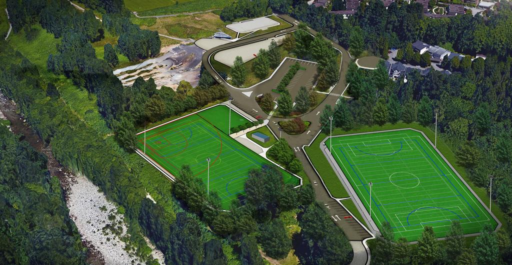
13 Aerial Perspective
Inter River Park Sportsfields
 Inter River Park Sportsfields Council Workshop February 26, 2018 Presented by: Carolyn Girard, Park Planner, DNV Parks Susan Rogers, Parks Manager, DNV Parks Agenda 1. Potential for 2 nd ATF Field in Inter
New Brighton Park Shoreline Habitat Restoration Project
 Vancouver Board of Parks and Recreation and Port Metro Vancouver New Brighton Park Shoreline Habitat Restoration Project Conceptual Design Public Consultation August 26 September 9, 2015 Discussion Paper
City of Bonney Lake Allan Yorke Park. MASTER PLAN SUMMARY REPORT June 30, 2016
 City of Bonney Lake Allan Yorke Park MASTER PLAN SUMMARY REPORT June 30, 2016 TABLE OF CONTENTS INTRODUCTION PUBLIC INVOLVEMENT PROCESS MASTER PLAN North Park Central Park South Park East Park Field Development
CHAPPLES PARK MASTER PLAN
 CHAPPLES PARK MASTER PLAN Presentation of Preliminary Development Options Public Open House #2 Wednesday November 2 nd, 2016 TONIGHT S AGENDA 1. Welcome & Introductions 2. Presentation by Sierra Planning
Charles P. Johnson and Associates. Annapolis Landscape Architects
 Charles P. Johnson and Associates Annapolis Landscape Architects AGENDA Introduction Project Limits and Scope Site Analysis Opportunities & Constraints Program Goals Image Boards Design Alternatives Pros
CITY OF EDMONTON FIRST PLACE PROGRAM
 CITY OF EDMONTON FIRST PLACE PROGRAM Kirkness (3015 151 Ave NW) Consultation Meeting #2 June 23, 2015 Clareview Community Rec Centre (Rm MP #2) 3804 139 Ave NW AGENDA 1. Opening comments. 2. Firm Up Site
ANCHORAGE PARK REPORT CARD Assessing A Park s Appearance, Function, & Condition
 ANCHORAGE PARK REPORT CARD Assessing A Park s Appearance, Function, & Condition Park Name: Is Your Park an A or an F? Your Name: Contact Information Optional: Date: General Instructions: Phone: Email:
2. Analysis. DRAFT Gerald Richards & Pleasantview Park Master Plan
 DRAFT Gerald Richards & Pleasantview Park Master Plan 19 Historic Features According to the National Register of Historic Places and the National Historic Landmarks Program, there is nothing of national
Design Specifications & Requirements Manual
 11 PARKS & OPEN SPACES 11.1 DEFINITIONS... 1 11.1.1 Neighbourhood Parks... 1 11.1.2 District Parks... 1 11.1.3. Sport Parks... 1 11.1.4 Urban Parks... 1 11.1.5 Civic Spaces... 1 11.1.6 Open Space System...
Design Specifications & Requirements Manual
 11 PARKS & OPEN SPACES 11.1 DEFINITIONS... 1 11.1.1 Neighbourhood Parks... 1 11.1.2 District Parks... 1 11.1.3. Sport Parks... 1 11.1.4 Urban Parks... 1 11.1.5 Civic Spaces... 1 11.1.6 Open Space System...
1. Parks & Recreation Neighborhood Parks Community Parks Special Use Sites 2. Open Space 3. Trails
 Appendix A: Park Classifications The intent of parks and recreation classifications is to aid in making acquisition and design decisions for park sites, facilities and the organization of recreation space
Long Branch-Wayne Local Park Renovation Project
 Montgomery Parks Long Branch-Wayne Local Park Renovation Project Community Meeting #2 September 20, 2016 Oak View Elementary School 7:00-9:00 PM Welcome / Team Introductions M-NCPPC (Montgomery Parks)
This Review Is Divided Into Two Phases:
 Semiahmoo Town Centre Review The purpose of this review: To review the Semiahmoo Town Centre Concept Plan, originally approved in 1993, to ensure that this centre will continue to serve the needs of South
Mission Bay Park Master Plan Update: Fiesta Island Amendment (Information) Mission Bay Park Committee October 3, 2017
 Mission Bay Park Committee October 3, 2017") Mission Bay Park Master Plan Update: Fiesta Island Amendment (Information) Mission Bay Park Committee October 3, 2017 Tonight s Agenda Introduction & Project Overview Proposed Circulation Changes Overview
Mission Bay Park Master Plan Update: Fiesta Island Amendment (Information) Mission Bay Park Committee October 3, 2017 Tonight s Agenda Introduction & Project Overview Proposed Circulation Changes Overview
April 11, 2016 Park Board Chair and Commissioners General Manager Vancouver Board of Parks and Recreation New Brighton Salt Marsh - Preferred Concept
 TO: FROM: SUBJECT: April 11, 2016 Park Board Chair and Commissioners General Manager Vancouver Board of Parks and Recreation New Brighton Salt Marsh - Preferred Concept RECOMMENDATION A. THAT the Vancouver
Preliminary Sketch Plan for Fort Hunter Park
 Preliminary Sketch Plan for Fort Hunter Park Public Presentation November 19, 2009 Dauphin County Parks and Recreation 100 Fort Hunter Road Harrisburg, PA 17110 (717) 599-5188 www.dauphinc.org THOMAS COMITTA
OPPORTUNITIES AND CONSTRAINTS - OXBOW PARK ENTRANCE AND PUT-IN
 OPPORTUNITIES AT OXBOW EXISTING WETLANDS Site is undeveloped and we can design a park that works well from the start. SAND BEACH Potential to eliminate invasive species. DEBRIS (CONCRETE, OLD CARS) VEGETATION
L-1 LEGEND HOMES AT DEER HILL LAFAYETTE, CALIFORNIA
 LEGEND Soccer Field 100 Yards (300 ft) x 60 Yards (180 ft) 6 Vinyl-Coated Chainlink Fence 15 Vinyl-Coated Chainlink Fence DE See Sheet L-2 for Filed North Enlargement Plan ER Park Boundary HIL LR OA D
TOWN OF BETHLEHEM MEETING SUMMARY LOCAL WATERFRONT REVITALIZATION PROGRAM UPDATE
 TOWN OF BETHLEHEM LOCAL WATERFRONT REVITALIZATION PROGRAM UPDATE MEETING SUMMARY Purpose: LWRP Update Public Workshop #3 Date and Time: October 24, 2017, 6:00 pm - 8:00 pm Location: Town Hall, 445 Delaware
Chapter 3 Site Planning and Low Impact Development
 CHAPTER 3 Site Planning and Low Impact Development Chapter 3 Site Planning and Low Impact Development 3.0 Introduction The City of Charleston requires that major residential, large commercial (>1 acre),
Billing Code: DEPARTMENT OF HOUSING AND URBAN DEVELOPMENT [Docket No. FR-6072-N-01]
![Billing Code: DEPARTMENT OF HOUSING AND URBAN DEVELOPMENT [Docket No. FR-6072-N-01]](/thumbs/91/107309814.jpg "Billing Code: DEPARTMENT OF HOUSING AND URBAN DEVELOPMENT [Docket No. FR-6072-N-01]") This document is scheduled to be published in the Federal Register on 12/18/2017 and available online at https://federalregister.gov/d/2017-27194, and on FDsys.gov Billing Code: 4210-67 DEPARTMENT OF HOUSING
This document is scheduled to be published in the Federal Register on 12/18/2017 and available online at https://federalregister.gov/d/2017-27194, and on FDsys.gov Billing Code: 4210-67 DEPARTMENT OF HOUSING
City of Cornwall Municipal Class Environmental Assessment. Proposed Improvement and Extension of Lemay Street
 Welcome City of Cornwall Municipal Class Environmental Assessment Proposed Improvement and Extension of Lemay Street Redevelopment and Design of the Municipal Works Yard Public Information Centre #1 Thursday,
Littleton Fields Master Plan
 Town of Littleton Littleton Fields Master Plan September 25, 2017 Gale Associates, Inc. John M. Perry, P.E. Jeffrey F. Georges, MRLA About Gale Agenda Introduction and Purpose Background Investigation
MALLETTS BAY INITIATIVE
 MALLETTS BAY INITIATIVE Stormwater Management & Transportation Scoping Study January 19, 2017 Project Team Bryan Osborne Director of Public Works Sarah Hadd Director of Planning & Zoning Marshall Distel
Potential Green Infrastructure Strategies May 6, 2015 Workshop
 Potential Green Infrastructure Strategies May 6, 2015 Workshop Background The City of Cortland is developing the Tioughnioga Urban Headwaters Green Infrastructure Action Plan with funding from the National
FORT MISSOULA REGIONAL PARK
 FORT MISSOULA REGIONAL PARK Master Plan Refinement/ Design Development www.missoulaparks.org DHM Design/WGM Group December 3, 2008 Master Plan Report Fort Missoula Regional Park Guiding Principals i 6/14/01
Errol Heights Park and Community Garden Frequently Asked Questions March 22, 2018
 Errol Heights Park and Community Garden Frequently Asked Questions March 22, 2018 Question 1: What improvements are planned for Errol Heights Park? How will the community be engaged in the process to shape
Lawrencetown Beach & Rainbow Haven Beach
 Lawrencetown Beach & Rainbow Haven Beach Public Engagement Session Wednesday, September 27 th, 2017 6:00pm 8:00pm Cole Harbour Place 51 Forest Hills Pkwy, Dartmouth Agenda Welcome & Introductions Overview
Las Colonias Park Master Plan
 2013 Las Colonias Park Master Plan City of Grand Junction June 2013 Introduction Las Colonias Park, a 101 acre parcel on the edge of the Colorado River south of downtown, was deeded to the City of Grand
Meeting Agenda. City of Guelph. River Systems Advisory Committee. Agenda Items. Item 1, 2 and 3. Item 4 Ward to Downtown Pedestrian Bridge
 Meeting Agenda City of Guelph River Systems Advisory Committee September 19, 2018 City Hall, Meeting Room B From 4:00 to 6:00 p.m. Meeting Chair: Mariette Pushkar Agenda Items Welcome to all Item 1, 2
Town Centre Park Master Plan Update - Terms of Reference
 CoQuitlam For Committee Our File: 12-6100-20/14-001/1 Doc#: 2176441.V7 To: From: Subject: For: City Manager General Manager Parks, Recreation & Culture Services Town Centre Park Master Plan Update - Terms
EXHIBIT A LAND USE EQUIVALENCY MATRIX
 EXHIBIT A LAND USE EQUIVALENCY MATRIX Trade To Single Family Single Family Multi- Shopping Medical Nursing Trade From Detached (DU's) Attached (DU's) Family (DU's) Center (KSF) ALF (Beds) Hotel (Rooms)
Emerson Park Master Plan Update. Public Meeting III August 27, 2014
 Emerson Park Master Plan Update Public Meeting III August 27, 2014 Meeting Agenda: Project Update Presentation of Master Plan Components Discussion and Feedback The Path Forward: Building on the Concept
IOWA HIGHWAY 57 / WEST 1 ST STREET STUDY PUBLIC INFORMATIONAL MEETING APRIL 22, 2014
 IOWA HIGHWAY 57 / WEST 1 ST STREET STUDY PUBLIC INFORMATIONAL MEETING APRIL 22, 2014 INTRODUCTION The City of Cedar Falls and the Iowa Department of Transportation are conducting a Public Informational
Draft Environmental Assessment
 Draft Environmental Assessment CASCADE PARK Orem City, Utah A conversion of land protected under Section 6(f)(3) of the Land and Water Conservation Fund Act, Public Law 108-98 September 2017 For information,
Boeckman Road Extension
 Boeckman Road Extension Providing Safe Passage for Wildlife and Maintaining Habitat Connectivity By Kerry Rappold, City of Wilsonville Leslie Bliss-Ketchum, Portland State University October 20, 2008 Presentation
Community Visioning Workshop Prep
 Community Visioning Workshop Prep Visioning Workshop 73 Visioning Workshop: Public Events 1 2 3 4 74 Visioning Workshop: draft Schedule 75 Visioning Workshop: draft Schedule working to schedule stakeholder
The Cambie Corridor 2015 Fall workshop series. What we heard WORKSHOP OUTLINE
 The Cambie Corridor 2015 Fall workshop series W 16 AVE Area 5 CAMBIE CORRIDOR Phase 3 What we heard ovember 21, 2015, 9am-noon, 1:30-4:30pm Peretz Centre 89 Participants* WORKSHOP OUTLIE Introductions
The Illinois Department of Transportation and Lake County Division of Transportation. Route 173, including the Millburn Bypass
 The Illinois Department of Transportation and Lake County Division of Transportation welcome you to this Public Hearing for U.S. Route 45 from Illinois Route 132 to Illinois Route 173, including the Millburn
Northeast Quadrant Plan
 Northeast Quadrant Plan Northeast Quadrant Distinctive Features Land Use The Northeast Quadrant includes all the area within the planning area that is east of Interstate 5 and to the north of State Route
Highway 427 Industrial Secondary Plan Area 47 Schedule C Class Environmental Assessment For Arterial Roadways
 Welcome to Pubic Information Centre #1 Highway 427 Industrial Secondary Plan Area 47 Schedule C Class Environmental Assessment For Arterial Roadways Welcome to Open House # 1 Tonight, we invite you to.
COUNTY OF ALBEMARLE PLANNING STAFF REPORT SUMMARY
 COUNTY OF ALBEMARLE PLANNING STAFF REPORT SUMMARY Project Name: SP2006-43 Field School Planning Commission Public Hearing: April 4, 2007 Owners: Claudius Crozet Park, Inc. (Robert A. Maupin, President)
OVERMOUNTAIN VICTORY TRAIL BURKE CALDELL CORRIDOR FEASIBLITY STUDY REQUEST FOR QUALIFICATIONS CALDWELL COUNTY PATHWAYS
 OVERMOUNTAIN VICTORY TRAIL BURKE CALDELL CORRIDOR FEASIBLITY STUDY REQUEST FOR QUALIFICATIONS CALDWELL COUNTY PATHWAYS Caldwell County Pathways along with our co-partners City of Lenoir, Town of Gamewell,
Play areas overlooking climbing hill. School & playgrounds overlooking pond bottom ballfields. Project experience while at Loris and Associates, Inc.
 City of Thornton Parks & Open Space Cherrywood Park Thornton, CO Architect: Design Concepts Construction of this seven-acre City park, located adjacent to Adams Twelve Five Star Prairie Hills Elementary
WELCOME! 8 8:30 6: TH STREET IMPROVEMENTS. Open House. Presentation & Q&A
 WELCOME! 168 TH STREET IMPROVEMENTS 6:30 Open House 7 8 Presentation & Q&A 8 8:30 Open House WELCOME Todd Pfitzer City of Omaha Engineer Bob Stubbe City of Omaha Public Works Director Jon Meyer Project
Welcome to our public exhibition
 About Our Scheme Welcome to our public exhibition This exhibition gives you the chance to view and comment upon our emerging proposals for a new residential development of 68 new homes on the site of the
Access. Chapel Parking & Entry Loop Snowbridge Square Skier/Visitor Parking. Dumpster Access. 3 Entry Monument Future Chapel Park
 EXHIBIT 1.1: RENDERED PLAN & CHARACTER Surrounding landscape patterns reach into the site connecting the new hotel to the surrounding resort. Guests are lead towards the hotel entry via the aspen wave
Working Group Meeting
 April 4,, 2017 Parks Operations Bldg Working Group Meeting Arts Districts Overview Stormwater/RPA/Stream Considerations First Principles Agenda 7:00pm 7:05pm 7:10pm 7:40pm 8:30pm 9:40pm 9:45pm Welcome
URBAN DESIGN BRIEF. 2136&2148 Trafalgar Road. Town of Oakville
 URBAN DESIGN BRIEF 2136&2148 Trafalgar Road Town of Oakville Prepared By: METROPOLITAN CONSULTING INC For 2500674 Ontario Inc November 2016 TABLE OF CONTENTS Page No. 1.0 Introduction/Description of Subject
Verona Area School District New High School Site Plan Review Written Description EUA Project No.:
 January 31, 2018 Adam Sayre, AICP Director of Planning and Development City Of Verona 111 Lincoln Street Verona, Wisconsin Re: Verona Area School District New High School Site Plan Review Written Description
Town of Lyons Parks Flood Recovery Planning Process. Photograph courtesy of Ed Bruder
 Town of Lyons Parks Flood Recovery Planning Process Photograph courtesy of Ed Bruder Lyons Parks and Recreation Flood Recovery Update 1. Meadow Park Phase II - Project PW20B1 Estimated Completion: Summer
PURPOSE AND NEED FOR ACTION PUBLIC SCOPING LETTER SILVER GLEN SPRINGS RECREATION ENHANCEMENT PROJECT. Ocala National Forest
 File Code: 1950/2300/2720 PUBLIC SCOPING LETTER SILVER GLEN SPRINGS RECREATION ENHANCEMENT PROJECT Lake George Ranger District Marion County, Dear Visitor: The of the has developed a proposal (Proposed
ROBERTS FIELD BRANDING GOALS NEW BRANDING PROJECT
 ROBERTS FIELD NEW BRANDING PROJECT Create branding and logos for Roberts Field and park areas including Friendship Park, The Wildlife Sanctuary and The Playing Fields. Best define use and expectations
STANDARD DETAILS QUICK REFERENCE
 STANDARD DETAILS QUICK REFERENCE Note: DWGs need to be saved locally before opening file. Requires AutoCad, DWG TrueView, or Autodesk Design Review (the later two are available for free from http://usa.autodesk.com/)
BROOKHILL NEIGHBORHOOD MODEL ZONING MAP AMENDMENT PREFACE TO APPLICATION
 BROOKHILL NEIGHBORHOOD MODEL ZONING MAP AMENDMENT PREFACE TO APPLICATION June 15, 2015 Revised: August 1, 2016 I. VISION Brookhill is a proposed community based upon the principles of Albemarle County
The principal elements of the NTC Strategic Vision plan are as follows.
 The proposed project would improve the NTC site plan, circulation, visitor amenities, and landscaping, and would include construction of two new stadiums to replace the existing Louis Armstrong Stadium
4-Town Comprehensive Plan DRAFT 7/30/07
 4-Town Comprehensive Plan DRAFT 7/30/07 Acknowledgements ning Committee Town of Harrisburg Norman Roof Randy Nicol Town of Martinsburg Terry Thisse Paul Kelly Town of Montague Jan Bagdanowicz Wendy Perry
Whitemarsh Comprehensive Plan Update: Housing & Land Use. Public Workshop #3: September 20, 2018
 Whitemarsh Comprehensive Plan Update: Housing & Land Use Public Workshop #3: September 20, 2018 Agenda Welcome Process Recap What We ve Heard The Plan Framework Review of Recommended Actions Land Use Housing
Tonight s Agenda. Disbrow Park & Facilities Master Plan
 Disbrow Park & Facilities Master Plan Public Outreach Forum City of Rye, NY May 11, 2017 Tonight s Agenda. Break (10 min) Introduction: What s in the works? Stantec Presentation - Goals and objectives
Point Defiance Park. Master Plan Update. April 23 rd 2015
 Point Defiance Park Master Plan Update April 23 rd 2015 Public Participation 1/29, 2/26, 3/26 & 4/23 Tonight s Agenda: Introduction: March Meeting Recap: Overview Feedback Responses Presentation of Master
Gold Line Bus Rapid Transit Transit Oriented Development (BRTOD) Helmo Station Area Plan
 Helmo Station Area Plan") Appendix F Gold Line Bus Rapid Transit Transit Oriented Development (BRTOD) Helmo Station Area Plan Introduction and Purpose of the Plan The Gold Line Bus Rapid Transit facility is an eleven-mile dedicated
Appendix F Gold Line Bus Rapid Transit Transit Oriented Development (BRTOD) Helmo Station Area Plan Introduction and Purpose of the Plan The Gold Line Bus Rapid Transit facility is an eleven-mile dedicated
BENJAMIN BANNEKER PARK FRAMEWORK PLAN (PLAN ADOPTION)
") BENJAMIN BANNEKER PARK FRAMEWORK PLAN (PLAN ADOPTION) COUNTY BOARD MEETING DECEMBER 16, 2017 County Board Consideration: Adopt the Benjamin Banneker Park Framework Plan and Design Guidelines Framework
BENJAMIN BANNEKER PARK FRAMEWORK PLAN (PLAN ADOPTION) COUNTY BOARD MEETING DECEMBER 16, 2017 County Board Consideration: Adopt the Benjamin Banneker Park Framework Plan and Design Guidelines Framework
Master Plan Workshop October 25, 2007 Charlotte Mecklenburg Government Center
 Master Plan Workshop October 25, 2007 Charlotte Mecklenburg Government Center Land Discussion 1. What are the most important land related issues we need to address? Protect natural areas Passive walking
DRAFT ALDER CREEK FARM MASTER PLAN
 DRAFT ALDER CREEK FARM MASTER PLAN Lower Nehalem Community Trust Mission: To preserve land and nurture conservation values in partnership with an engaged community in the Nehalem region of the Oregon Coast
CHAPPLES PARK MASTER PLAN. Presentation to Council April 10, 2017
 CHAPPLES PARK MASTER PLAN Presentation to Council April 10, 2017 1 PRESENTATION AGENDA 1. Project Background, Aim and Process 2. The Site Issues and Opportunities 3. Community Engagement 4. Vision and
NORTH DISTRICT. Description
 VI plan and major recommendations district plans north disrict NORTH DISTRICT Description The North District comprises approximately 105 acres and is bounded by two important bio-habitats and corridors
Public Open House. Welcome! Presentation at 5:15 p.m. Please sign-in at the registration table
 Public Open House Welcome! Presentation at 5:15 p.m. Please sign-in at the registration table The Grand Avenue Extension Location and Environmental Study will determine the location of the extension of
May 3, 2010 MEMORANDUM. Dr. Douglas Palmer Chair, Council for the Built Environment. Proposed Lighting of New Recreational Sports Fields
 Council for the Built Environment technical subcommittee May 3, 2010 MEMORANDUM To: Subject: Dr. Douglas Palmer Chair, Council for the Built Environment Proposed Lighting of New Recreational Sports Fields
Mavis Road Class Environmental Assessment
 Mavis Road Class Environmental Assessment Public Information Centre #2 Wednesday November 9, 2016 6:00 to 8:00 p.m. Please sign in and complete a comment sheet Review the displays on your own or join in
Alternatives Development Three conceptual alternatives were developed for the Race Road/Jessup Village Planning Study and are described below:
 Race Road/Jessup Village Planning Study (H550601) Project Newsletter Spring 2015 Project Description The Study Team, consisting of staff from Anne Arundel County (Department of Public Works and Department
WELCOME WHY A TEMPORARY PATHWAY? WE WANT TO HEAR FROM YOU
 WELCOME In March, the City of Vancouver purchased the lands known as the Arbutus Corridor from Canadian Pacific Railway for the purpose of creating a transportation corridor from False Creek to the Fraser
Report or technical documentations of the target areas in Siauliai
 WP 4 Energy Supply Report or technical documentations of the target areas in Siauliai 2011.10.27 Summary of the draft version of technical documentation for two target areas Lieporiai park 1.1. Works basis
APPENDIX E: CITY OF HAMILTON* STANDARD REQUIREMENTS FOR PARK OR OPEN SPACE DEVELOPMENT
 * Standard Requirements by Open Space Development and Park Planning Section (OSD & PP) of Capital Planning and Implementation Division (CP&I) of Public Works. 1.1 Standard Comments at Draft Plan Approval
Welcome to our exhibition
 Welcome to our exhibition The Homes & Communities Agency (HCA) welcomes you to this public exhibition explaining our proposals for the redevelopment of the former Lea Castle Hospital site. About the Homes
CHAPTER 7: PARKS, OPEN SPACES AND RECREATION
 CHAPTER 7: PARKS, OPEN SPACES AND RECREATION The delivery of Parks and Recreation services in Port Moody aims to provide benefits, either direct or indirect, to all citizens in the community. There is
I-494 Rehabilitation Project SP (I-394 to Fish Lake Interchange) June 2014 Section 4(f) De Minimis Determination
 June 2014 Section 4(f) De Minimis Determination") I-494 Rehabilitation Project SP 2785-330 (I-394 to Fish Lake Interchange) June 2014 Section 4(f) De Minimis Determination State Project Number 2785-330 Federal Project No. NHPP-I494 (002) Trunk Highway:
I-494 Rehabilitation Project SP 2785-330 (I-394 to Fish Lake Interchange) June 2014 Section 4(f) De Minimis Determination State Project Number 2785-330 Federal Project No. NHPP-I494 (002) Trunk Highway:
Section 3 INVENTORY OF RECREATION LAND AND FACILITIES
 Photo of Juan Bautista de Anza Park Section 3 INVENTORY OF RECREATION LAND AND FACILITIES Summary of Findings Park Definitions Summary of Recreation Facilities Other Recreation Facilities Nearby Recreation
PRELIMINARY CONDITIONAL USE SUBMITTAL CHECKLIST REQUIREMENTS
 This checklist must accompany your submittal as the cover page. CONDITIONAL USE Application Submittal Checklist for PRELIMINARY AND FINAL APPROVAL Per Winter Park Land Development Code Sec. 58-90 PRELIMINARY
City of Farmington. Downtown Plan. Amendment to the 1998 Master Plan Adopted October 11, 2004
 City of Farmington Amendment to the 1998 Master Plan Adopted October 11, 2004 Introduction Planning Background 1 Scope and Components of the Plan Amendment 2 Concept Introduction 3 Plan Concepts 3 Conceptual
PRELIMINARY DESIGN + DEVELOPMENT PLAN
 WELCOME! To The Public Open House May 30 th, 2017 HARBOUR WEST PARKS Vision Project Overview The City s vision for Port Credit Harbour West Parks is to develop a vibrant waterfront destination that integrates
Better Cycling. The City will update the cycling master plan (London ON Bikes) based on the approved BRT network.
 based on the approved BRT network.") Better Cycling Dedicated bike facilities will be constructed along BRT corridors where space is available. Nearby bike routes will also be upgraded to ensure a complete network is available for cyclists.
Better Cycling Dedicated bike facilities will be constructed along BRT corridors where space is available. Nearby bike routes will also be upgraded to ensure a complete network is available for cyclists.
MASTER PLAN IMPLEMENTATION COSTS. Appendix A
 Appendix A MASTER PLAN IMPLEMENTATION COSTS Town of Bradford West Gwillimbury HENDERSON COMMUNITY PARK MASTER PLAN IMPLEMENTATION COSTS Draft Order of Magnitude Costing Revised 5/27/2014 ITEM DESCRIPTION
Saranac River Trail Greenway C O N D I T I O N S R E P O R T
 Saranac River Trail Greenway C O N D I T I O N S R E P O R T City of Plattsburgh Clinton County, NY For: Clinton County Final Issued: March 22, 2017 This document was prepared for the New York State Department
FURNEAUX CREEK 5 CHANNEL
 FURNEAUX CREEK 5 CHANNEL AND TRAIL IMPROVEMENTS TEXAS CHAPTER AMERICAN PUBLIC WORKS ASSOCIATION PROJECT OF THE YEAR CATEGORY: ENVIRONMENT PROJECT OF $2 MILLION BUT LESS THAN $5 MILLION ENGINEERING DEPARTMENT,
The Recreational Heart of Cannington - MacLeod & Claire Hardy Parks
 The Site Claire Hardy Park and MacLeod Park are both located within the community of Cannington on opposing shorelines of the Beaver River and are accessible to each other by a footbridge spanning the
SECTION 4(f) DE MINIMIS DOCUMENTATION
 DE MINIMIS DOCUMENTATION") SECTION 4(f) DE MINIMIS DOCUMENTATION Illinois Route 60/83 IL 176 to the intersection of IL 60 (Townline Road) Lake County P-91-084-07 Mundelein Park and Recreation District Project Limit SECTION 4(f)
SECTION 4(f) DE MINIMIS DOCUMENTATION Illinois Route 60/83 IL 176 to the intersection of IL 60 (Townline Road) Lake County P-91-084-07 Mundelein Park and Recreation District Project Limit SECTION 4(f)
Hidden Pointe Landscape Master Plan. June, archi terra
 Hidden Pointe Landscape Master Plan June, 2006 t h e archi terra g r o u p 1 Table of Contents Background Purpose and Goals of the Master Plan Master Plan Process Existing Conditions Entrance Hidden Pointe
City Council March 27, Parks, Recreation, and Trails Master Plan
 City Council March 27, 2018 Parks, Recreation, and Trails Master Plan Planning Process Develop Goals and Objectives Inventory of Areas and Facilities Needs Assessment And Identification Public Participation
BISCUIT RUN PARK MASTER PLAN
 BOARD OF SUPERVISORS November 14, 2018 BISCUIT RUN PARK MASTER PLAN COUNTY OF ALBEMARLE ANHOLD ASSOCIATES Contents Project Introduction Property Background County Park Planning Process Existing Site &
GREENBANK DEVELOPMENT MASTERPLAN
 DEVELOPMENT MASTERPLAN POTENTIAL TRAIN STATION COMMUNITY CENTRE Greenbank will be a connected masterplanned community providing easy access to local and surrounding amenity. Affordable quality homes, green
Inform you of the purpose and scope of the study for PTH 100 and a proposed future St. Norbert Bypass;
 WELCOME The intent of today s Open House is to: Inform you of the purpose and scope of the study for PTH 100 and a proposed future St. Norbert Bypass; Review highway crossing locations, future access closures
Y Sports Complex PROGRAMMING Capitol Improvement Plan. Anticipated/Suggested Improvements. Sedgwick County Park: Sports Complex:
 PROJECT OVERVIEW Location: East of Ridge Road, between 21 st Street and 13 th Street, not including SCZ In conjunction with The Sedgwick County Park Facilities Observation Report Compilation of improvements
CHAPTER 7: Transportation, Mobility and Circulation
 AGLE AREA COMMUNITY Plan CHAPTER 7 CHAPTER 7: Transportation, Mobility and Circulation Transportation, Mobility and Circulation The purpose of the Transportation, Mobility and Circulation Chapter is to
Blackfriars Bridge Municipal Class Environmental Assessment. Public Information Centre #1 November 19 th, 2014
 Blackfriars Bridge Municipal Class Environmental Assessment Public Information Centre #1 November 19 th, 2014 Why are you here tonight? To determine the future requirements of the river crossing at Blackfriars
ADDENDUM TO BIOLOGICAL SCOPING SURVEY REPORT, BOTANICAL SURVEY AND WETLAND DELINEATION
 ADDENDUM TO BIOLOGICAL SCOPING SURVEY REPORT, BOTANICAL SURVEY AND WETLAND DELINEATION FOR AVALON INN (APN 069-241-27 & -04) 1201 & 1211 NORTH MAIN STREET FORT BRAGG, CA MENDOCINO COUNTY prepared for:
1. Lenox Dale Community Character Strengths and Opportunities Identified by Residents: Strong neighborhood identity and sense of community.
 LENOX DALE ISSUES AND OPPORTUNITIES -- EIGHT CATEGORIES: Concerns and opportunities identified by Lenox residents and in previous Community Surveys, along with thought-starter suggestions on possible Town
AVONDALE ESTATES GREENSPACE AD-HOC COMMITTEE
 AVONDALE ESTATES GREENSPACE AD-HOC COMMITTEE INVENTORY AND RECOMMENDATIONS REPORT November 7, 2018 Our Mission Statement: To provide assistance and support, through professional expertise in matters of
CITY OF OZARK STANDARD DRAWING DETAILS FOR PUBLIC IMPROVEMENTS
 CITY OF OZARK STANDARD DRAWING DETAILS FOR PUBLIC IMPROVEMENTS 2010 EDITION CITY OF OZARK, MISSOURI REVISIONS TO THE 2009 EDITION The following revisions have been made to the 2009 edition of the city
Open Space and Recreational Resources
 Chapter 3: Open Space and Recreational Resources A. INTRODUCTION Under the 2012 City Environmental Quality Review (CEQR) Technical Manual guidelines, open space is defined as publicly accessible, publicly
Community Engagement Committee Meeting #1 December 10, :30pm-8:30pm
 Community Engagement Committee Meeting #1 December 10, 2014 6:30pm-8:30pm Welcome and Introductions Dana Murdoch Minneapolis Park and Recreation Board Project Manager Ryan French Walker Art Center Director