Baraga Avenue PlacePlan Marquette, MI July 24 th, 2014
|
|
|
- Gervase Thompson
- 6 years ago
- Views:
Transcription

1 Baraga Avenue PlacePlan Marquette, MI July 24 th, 2014

2 Presentation Outline Project Purpose Acknowledgements Placemaking Overview PlacePlan Process Design Overview PlacePlan Recommendations Physical Design & Walkability Environmental Sustainability Cultural Economic Development Entrepreneurship Multiculturalism Transportation Options Messaging and Technology Education Next Steps Source:
3 Project Purpose
4 Selection: Marquette was one of 8 communities selected to receive PlacePlan assistance from Michigan State University and Michigan Municipal League under the MIPlace Partnership created by Governor Snyder. Purpose: The PlacePlan initiative aims to assist communities in Michigan to plan for projects that will impact the Quality of Place where they are conducted.
5 Acknowledgements

 and local")
6 This project was made possible by a grant from the Michigan State Housing Development Authority (MSHDA) and local partners.
7 Placemaking Overview


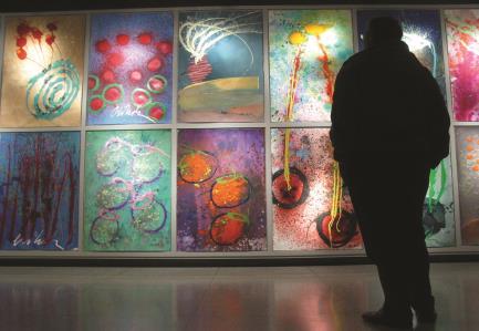
8 What is Placemaking? Good Form Sets the Stage To Activate Social Activity or the Play Emotional Response by the Audience Source: Source:

9 Characteristics of Placemaking Short-term Time Frame Long-term Tactical Placemaking Creative Placemaking Strategic Placemaking Density Welcoming Sociability Human Scale Safe Connected Comfort Quiet Civic Engagement Walkable Accessible Resilient


10 Better Communities. Better Michigan. Physical Design & Walkability Environmental Sustainability Cultural Economic Development Entrepreneurship Multiculturalism Transportation Options Messaging & Technology Education
11 PlacePlan Process


12 Process -Charrette Next Steps: -Funding Increased Talent Attraction & Retention Prosperity -Stakeholder Interviews -Community Visioning -Post-Charrette Input -Final Report -Partnerships -Implementation February 2014 July 2014
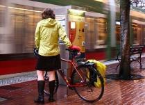
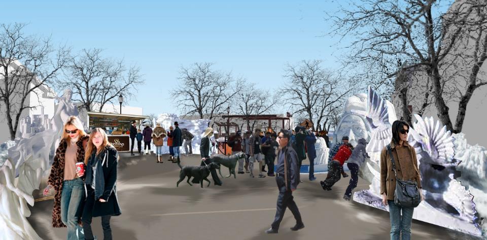
13 Meeting One: Visioning Session Natural Environment: Cleanliness, protection of natural environment, public access to Lake Superior, and forested trails surrounding city Built Environment: Walkability, bike paths, downtown, historic landmark signs, diverse amenities Held on February 27 th, 2014 Attendees were asked to consider what about Marquette they: Vision Sorry Proud Built Environment: Surface water runoff, overhead power lines, lack of funding for historical preservation, buildings block view of the lake Parking/Transportation: Lack of public transit, sea of parking off Baraga, width/disconnect of Baraga, Washington, and Third Streets, poor parking management Are proud of Are sorry about Would like to see in the Natural Environment: Greenery and flowers, improved lake vista, connection to the lake Built Environment: No overhead utilities, place to sit and eat, bike parking, less auto-oriented, better parking management future Reflect Share Listen Discuss

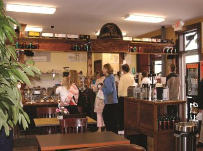
14 Meeting Two: Design Charrette On April 29 th and 30th, 2014, a multiple-day design charrette was held to gauge stakeholders feelings towards Baraga Avenue. The charrette consisted of the following segments: Introduction of design images, based on meeting one input Exchanging of thoughts and ideas about project Source: Writing comments on notecards and images
15 Project Overview

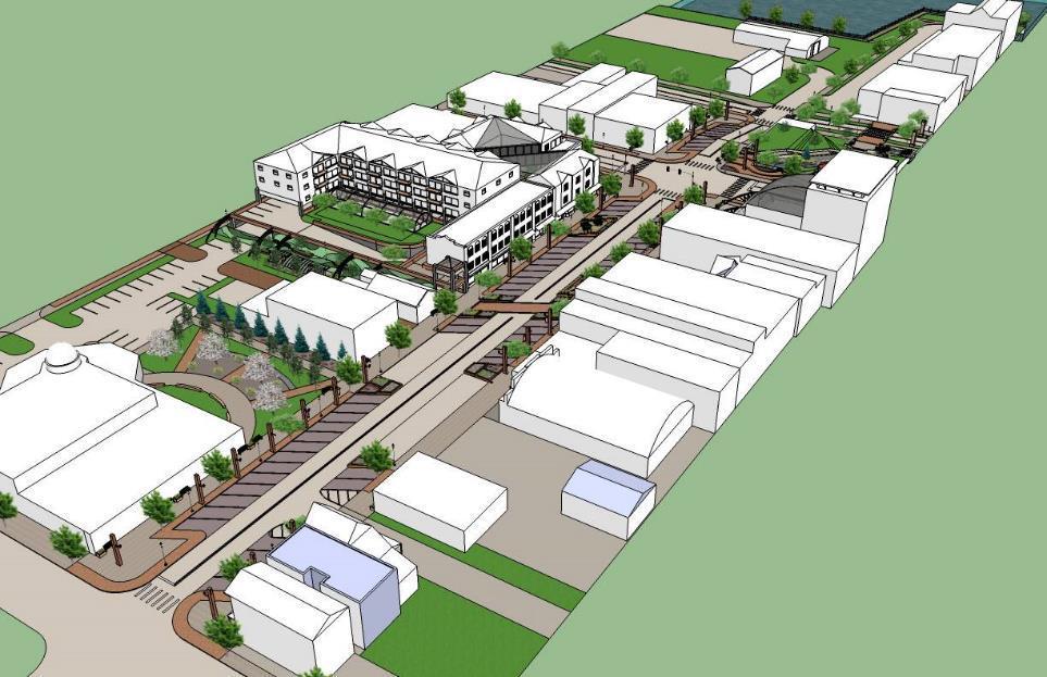
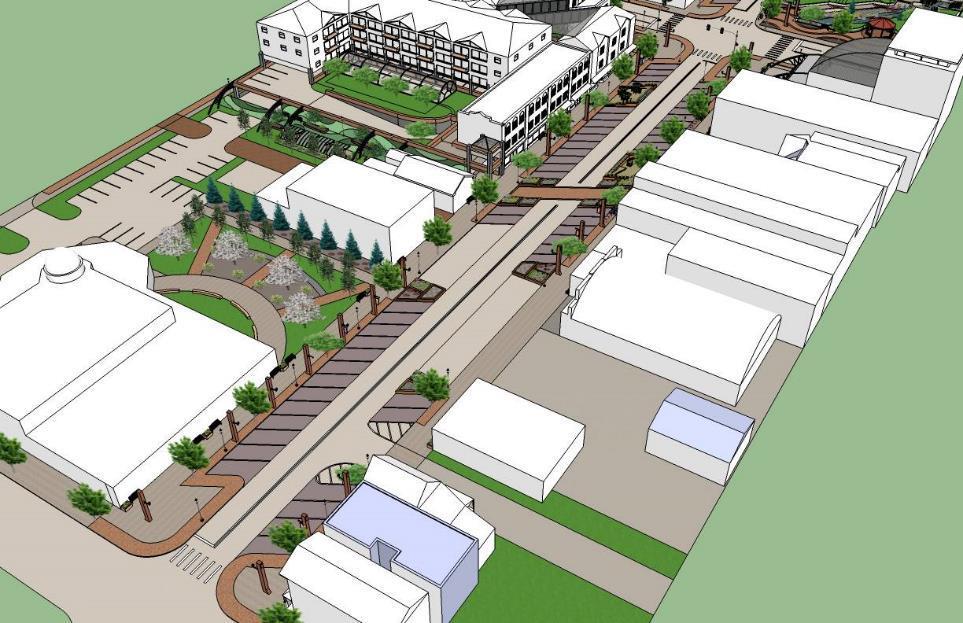
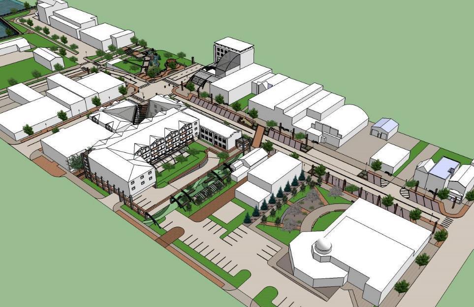
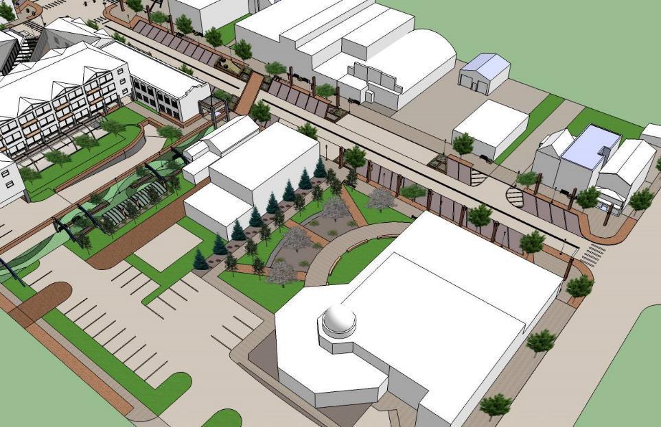
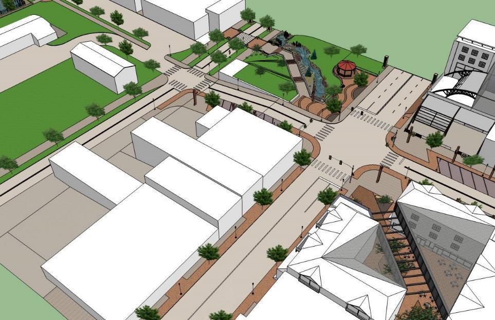
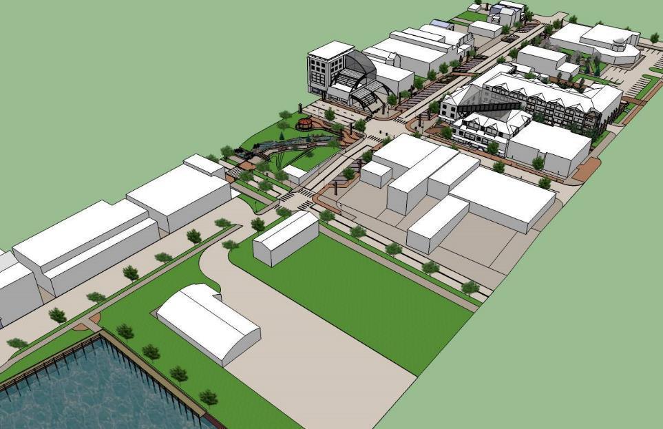
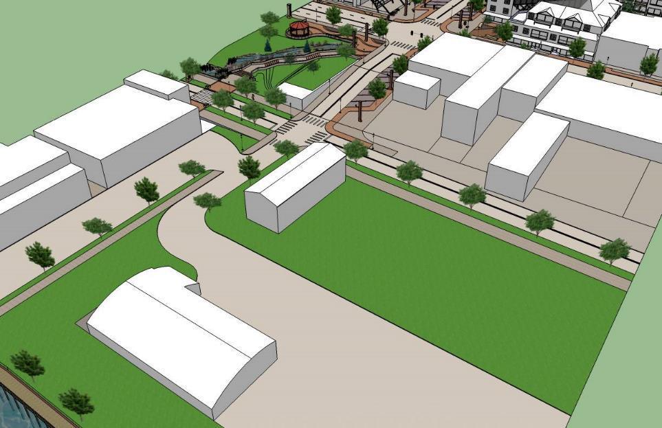
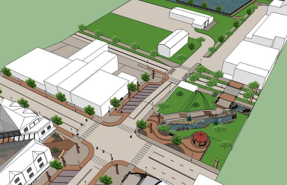
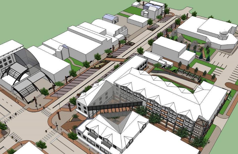
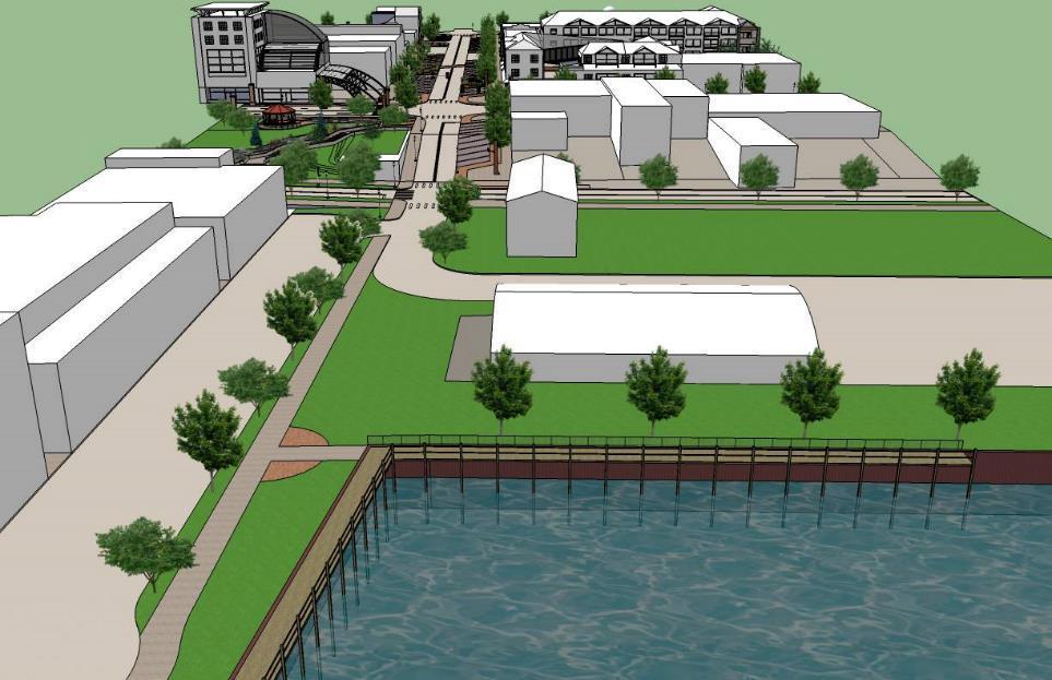
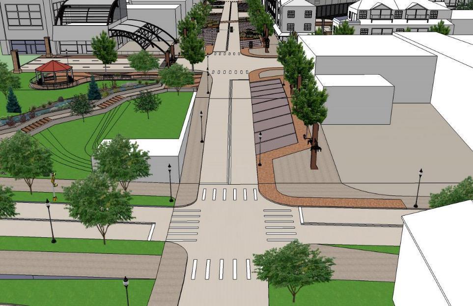
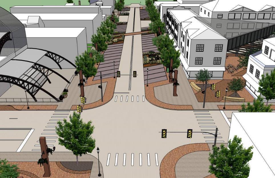
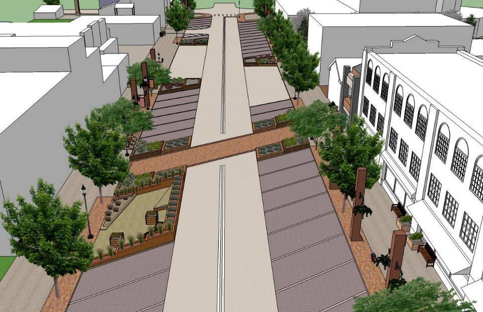
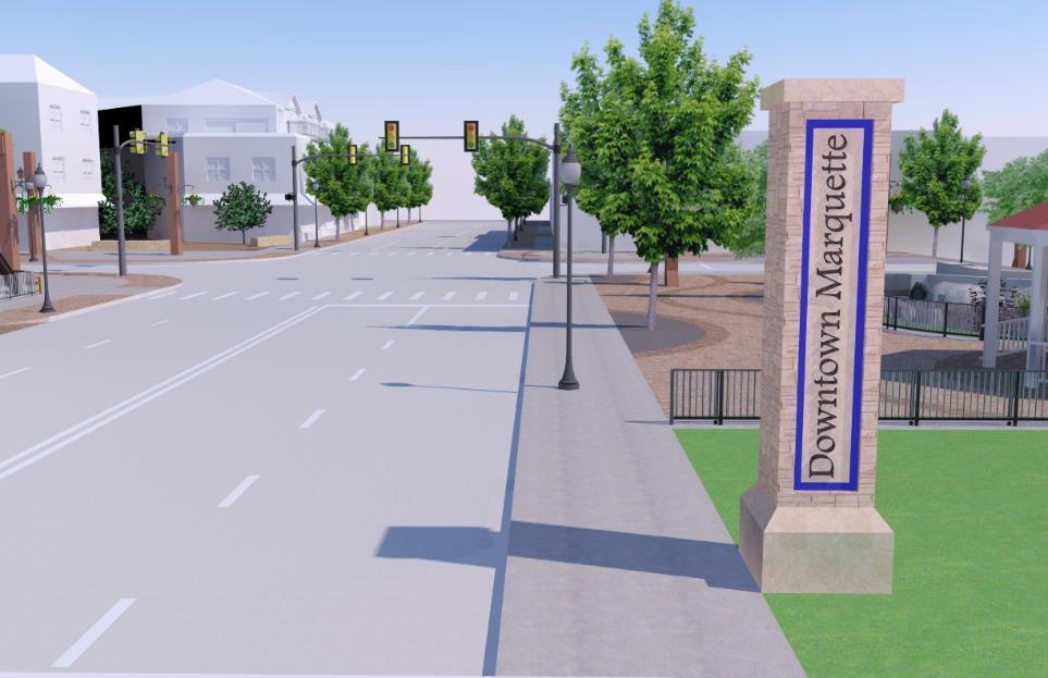
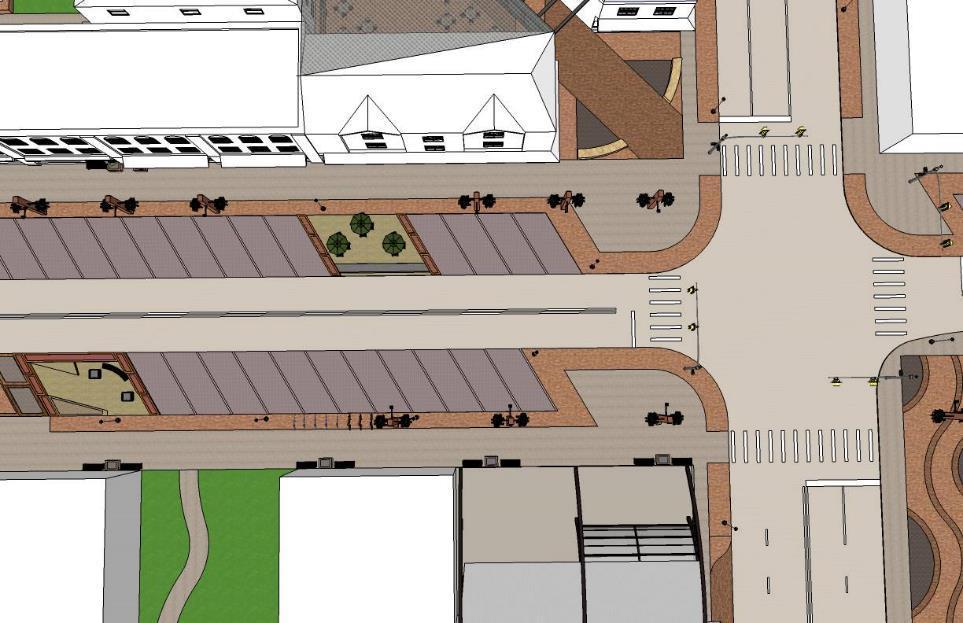
16 Source: Google Maps Location The proposed project, the 100 Blocks of Baraga Avenue, is generally bounded by Third Street to the west, Spring Street to the north, and Lake Superior to the east.


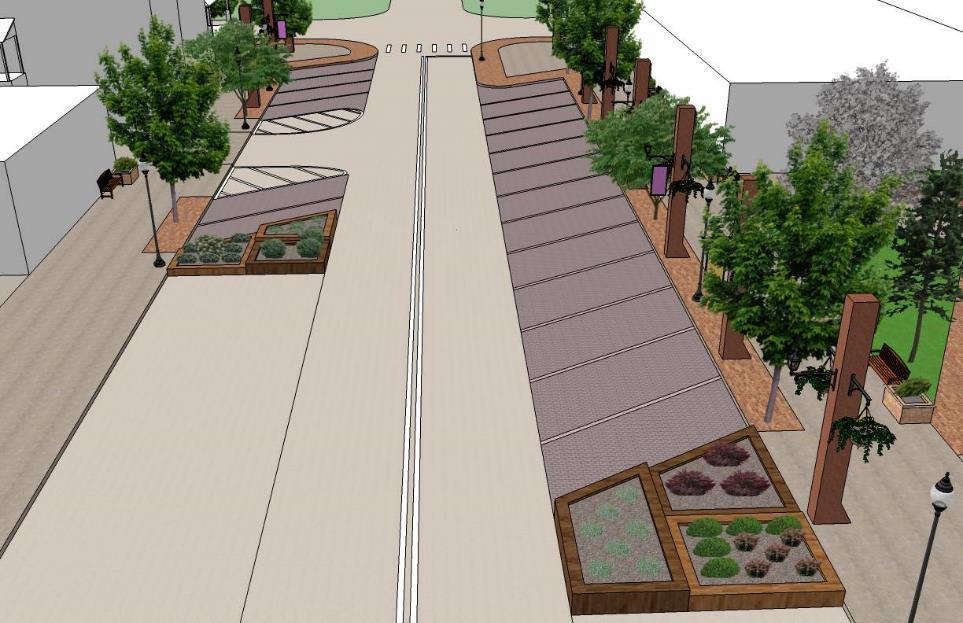
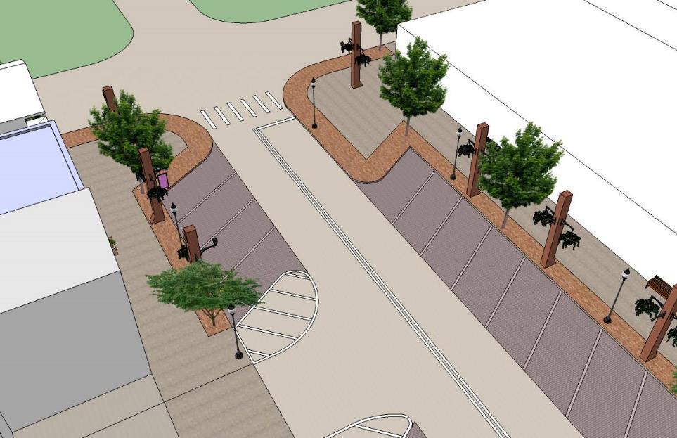
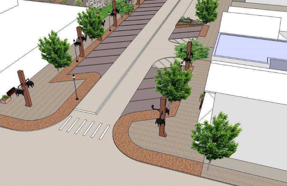
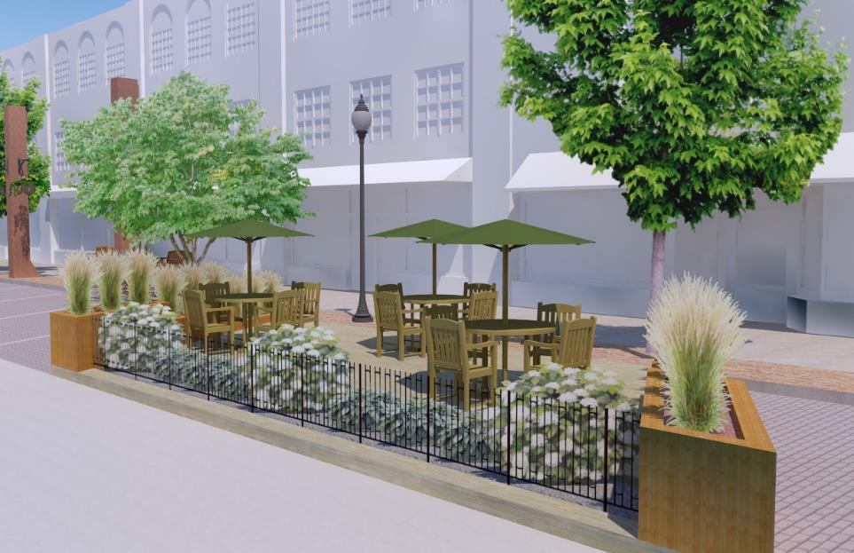
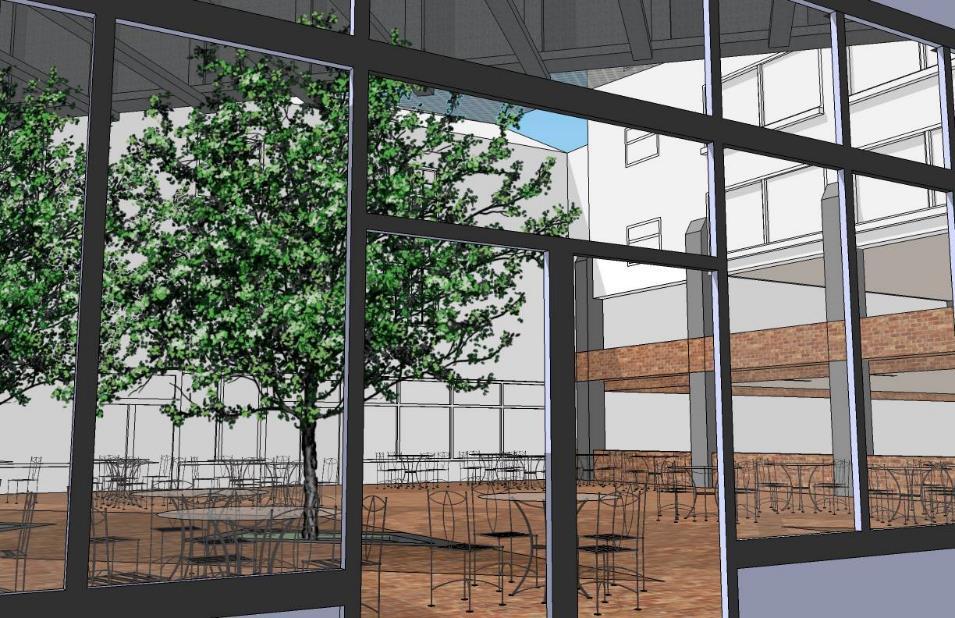
17 Project Description The proposed project includes the redesign and reconstruction of the 100 Blocks of West and East Baraga Avenue. The plan is needed to: Integrate the street into the rest of the downtown Make the street more accessible, walkable, and safe Provide traffic calming techniques Redesign parking Recreate the streetscape Provide public gathering space Bury the current overhead utilities Source: Marquette DDA Source: Marquette PlacePlan Application

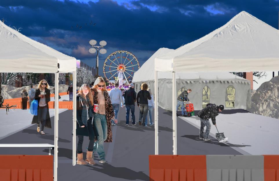
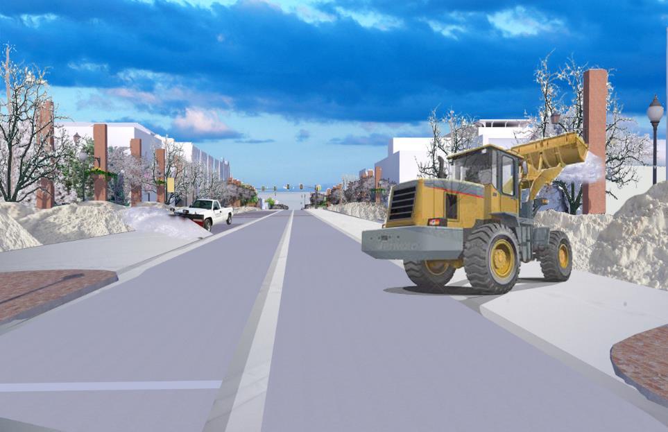
18 Design Parameters Greening of the project area Recreation/Entertainment/Housing Shopping/Eating (Reasons to go there) Year-round use for all ages Art Improve the facades of buildings Overall beautification Accessibility for all Historic character of Marquette Existing architecture Existing and newly developing cultures (students, creative arts, retirement communities, etc.) Lake Superior and the famous ore dock Material types Snow removal Connections to surrounding neighborhoods Source: Jim Koski


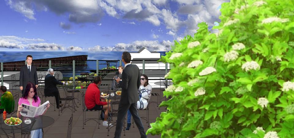
19 Key Design Principles Design multi-purpose/flexible space that can be used by all ages, in all seasons, residents and visitors alike Support and help build a stronger downtown, including after-hours activity Create a unique/special/authentic place to be Ensure environmentally sensitive design Source: gerdingedlen.com Source: Wikimedia Commons
 Include four season opportunity for year-round use Support day and evening use Design Baraga Avenue to be friendly to all modes of transportation, not just the automobile Reorient on-street parking")
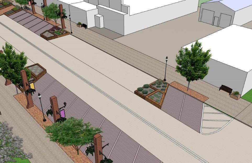
20 Key Design Principles (cont.) Include four season opportunity for year-round use Support day and evening use Design Baraga Avenue to be friendly to all modes of transportation, not just the automobile Reorient on-street parking from perpendicular to angled Provide more public space to increase the extent that businesses can use it for outdoor seating and café space Integrate a more sensitive and environmentally oriented stormwater management system Source: wanderingsheppard.com

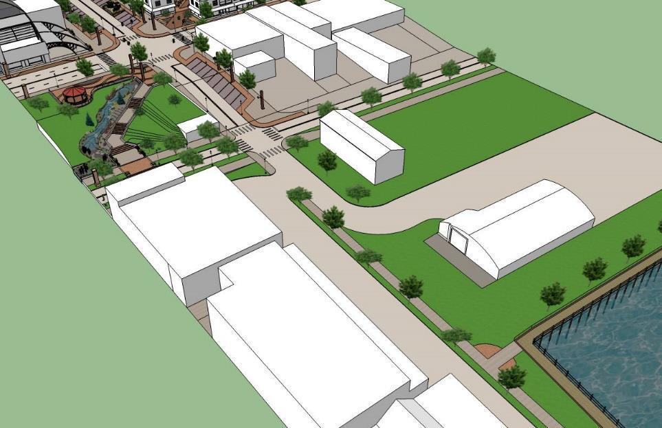
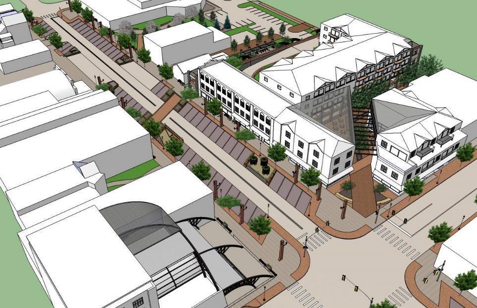
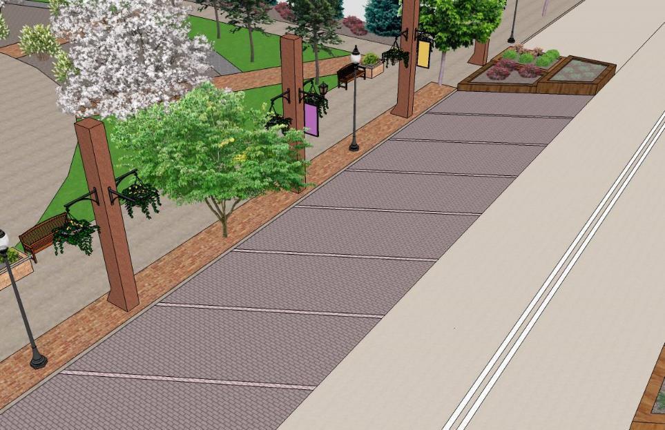
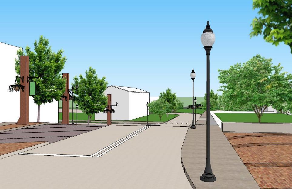
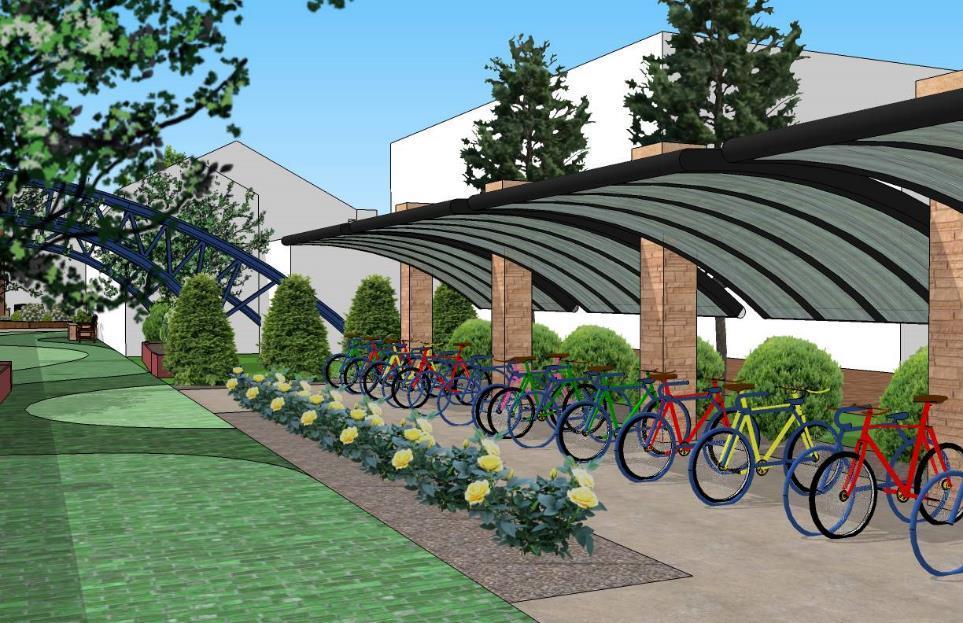
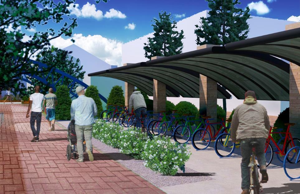
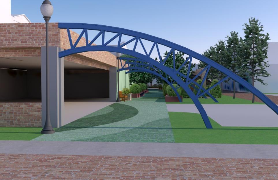
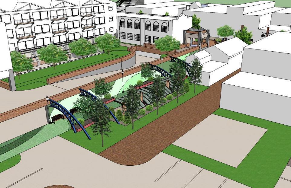
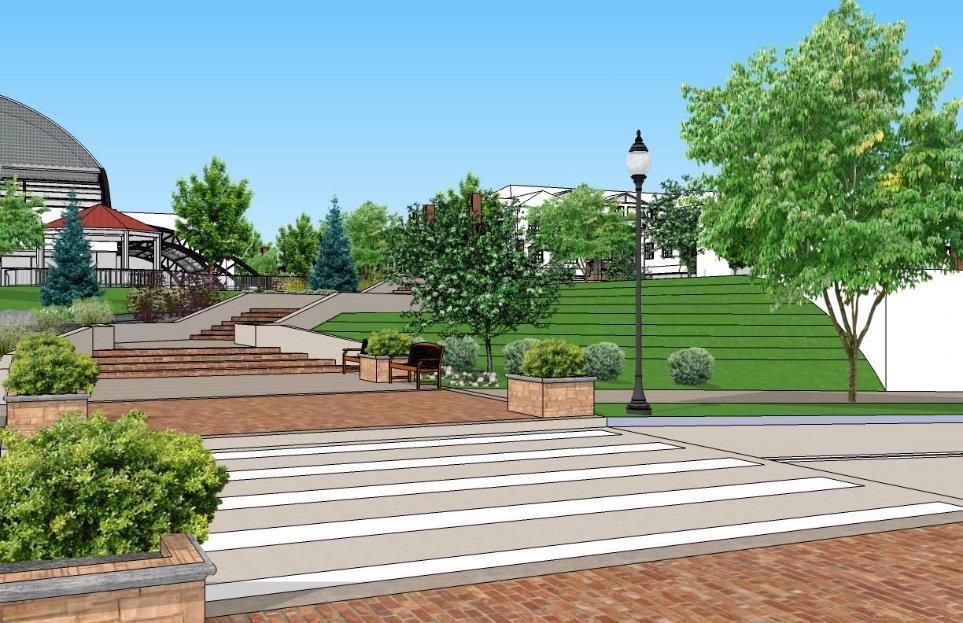
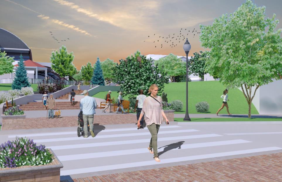
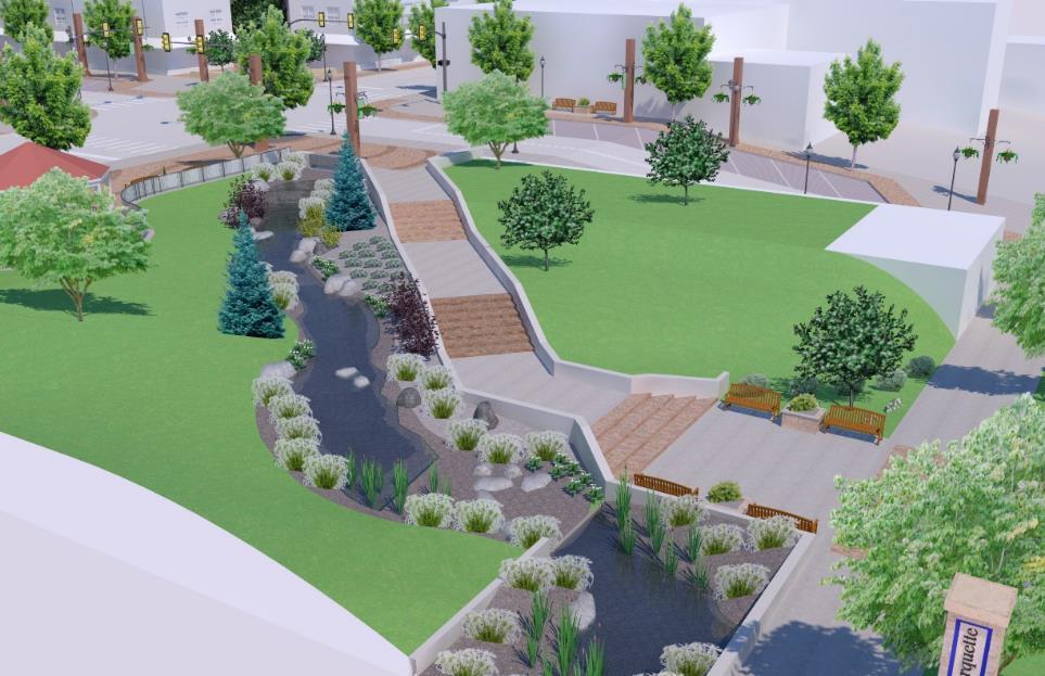
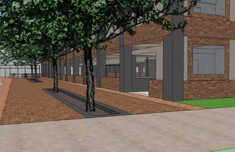
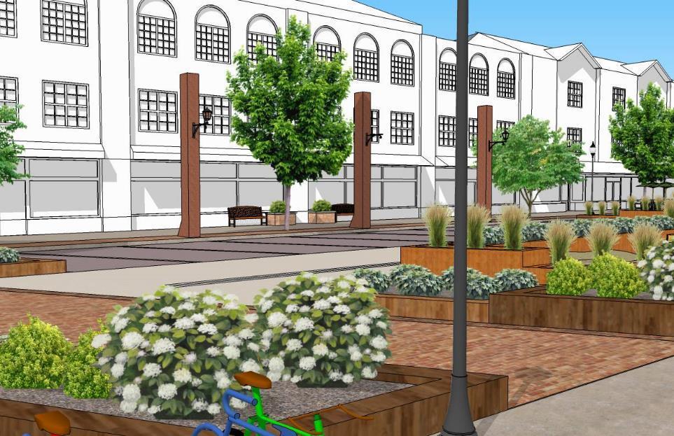
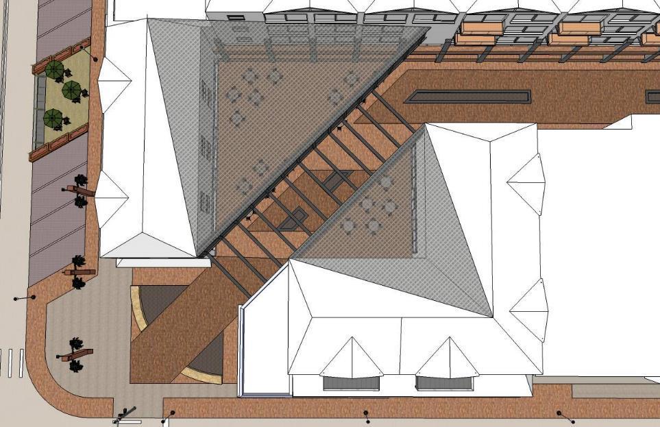
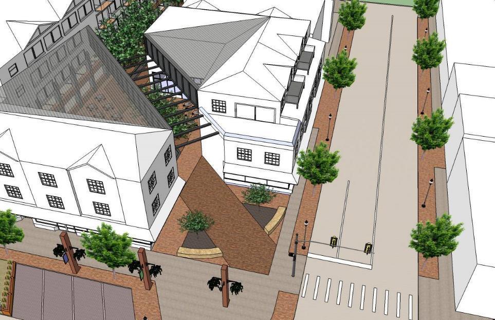
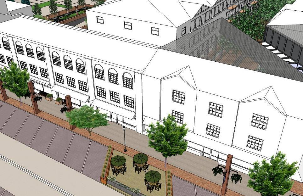
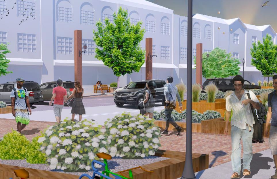
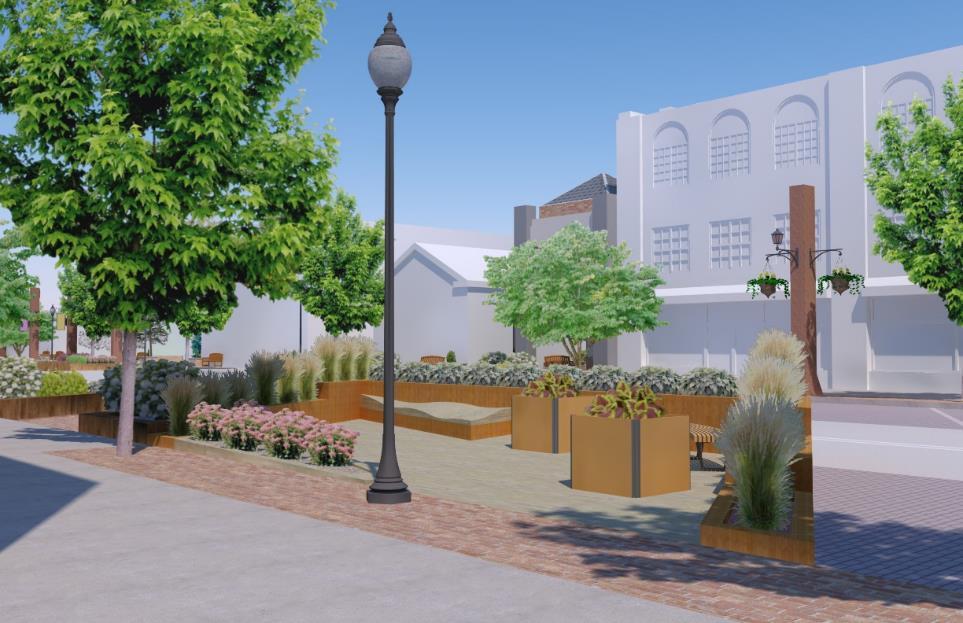
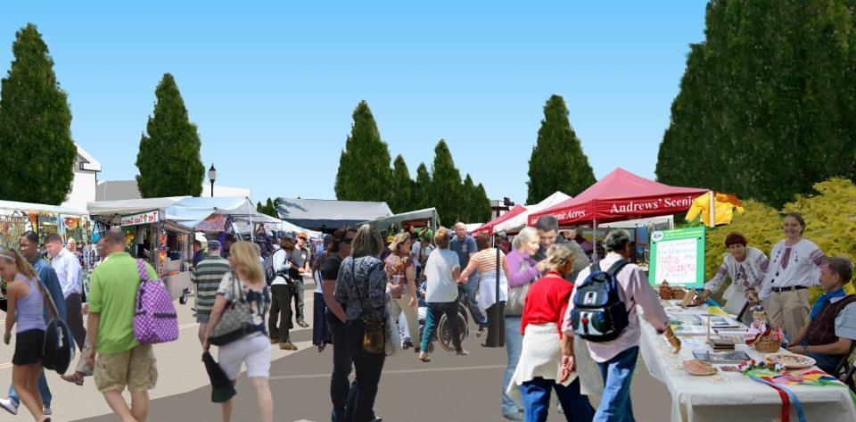
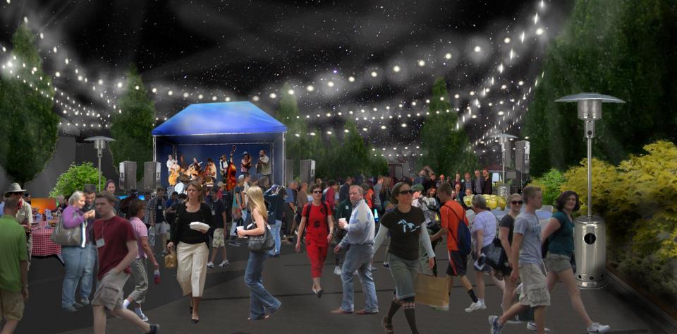
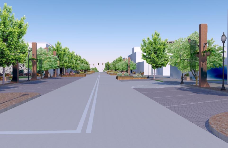
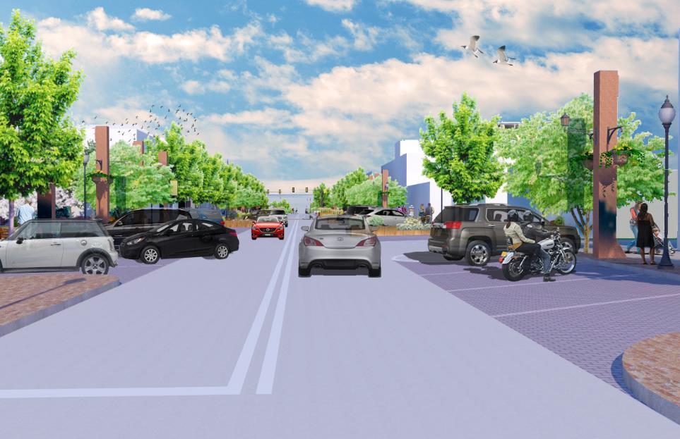
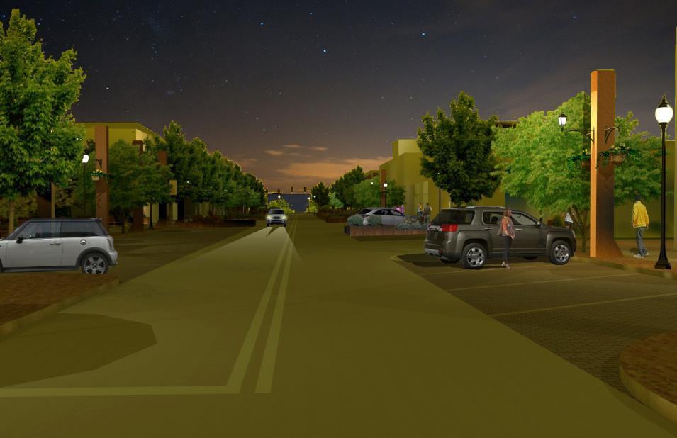
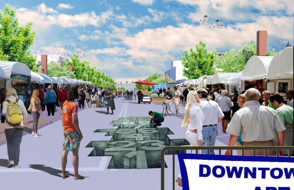
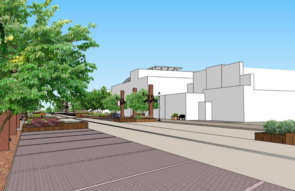
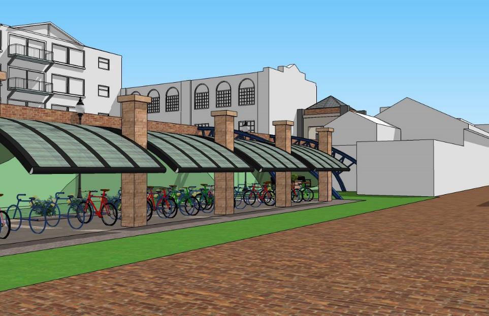
21 Design Concept Aerial
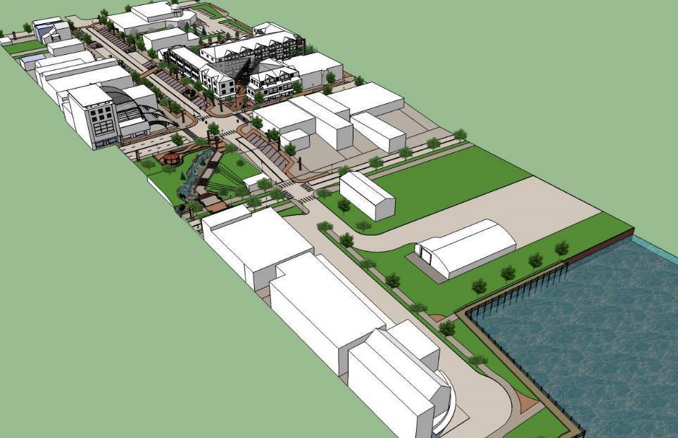
22
23
24
25
26
27
28
29
30
31
32
33
34
35
36
37
38
39
40
41
42
43 PlacePlan Recommendations
44 Physical Design & Walkability Identify opportunities to promote more active use of surface parking lots Encourage engaging facades on buildings that front Baraga and cross streets Update Promoting Active Communities assessment in 2015 Improve the uniformity and organization of buildings Improve measures to increase pedestrian safety, especially during the winter months
45
46
47
48
49
50
51 Physical Design & Walkability Implementation Strategies Short-term Time Frame Long-term Asset Category Implementation Strategies A1: Review off-street parking utilization; consider reducing off-street parking requirements for development and identify any under-used parking areas that could be used for development. A2: Use landscaping, art, and sidewalk furniture around the edges of parking lots to provide a buffer for pedestrians, or encourage temporary uses such as food trucks or outdoor cafes in parking areas adjacent to sidewalks A3: Consider extending the recent Third Street study recommendations, which were focused north of downtown, to Baraga A4: Use 2014 evaluation questions to identify additional opportunities for improvement, available online at A5: Explore funding options to bury all utility lines to create a better view down Baraga Avenue A6: Identify critical areas for heated sidewalks on ramps, stairs, or other potentially hazardous surfaces to improve pedestrian safety during winter A7: Enhance snow management practices to prevent interference with traffic calming and walkability design features A8: Consider amending the city zoning ordinance definition of alleyways to categorize by use and function. This categorization of alleyways will make it possible to distinguish between service-oriented (e.g. deliveries, trash pickup) and non-motorized uses (where pedestrian scale and activity should be allowed and encouraged). Tactical Creative Strategic
52 Environmental Sustainability Offer incentives and recognition to businesses and developers that pursue environmentally sustainable practices Pursue an alternative energy policy to improve efficiency and lessen environmental impact Use natural elements (e.g. trees, plants, rain gardens, etc.) to improve the environmental qualities of Baraga Avenue Enhance recycling options along Baraga Avenue
53
54
55
56 Environment Sustainability Implementation Strategies Short-term Time Frame Long-term Asset Category Implementation Strategies B1: Consider zoning standards that promote renewable energy and walkability B2: Create a reward and recognition program for businesses with the most energy efficient buildings B3: Consult the Guide to Purchasing Green Power Report in order to follow the correct process to transition to utilizing alternative energy. B4: Coordinate with the Marquette Board of Power and Light to identify opportunities for increasing the share of the city s energy coming from sustainable sources B5: Plant climate-resilient street trees along Baraga Avenue to create shade in the summer and to help break up wind in the winter. Additionally, these street trees will help beautify the space by introducing natural color B6: Plant natural wind screens (trees, bushes, etc.) where possible to reduce snow drifting and wind during the winter months B7: Install recycling bins near all trash cans to encourage recycling B8: Explore a storm water management feature within Father Marquette Park to provide a functional and aesthetic purpose Tactical Creative Strategic
57 Cultural Economic Development Brand Baraga Avenue as a cultural corridor by bringing the assets of the Children s Museum, Marquette County History Center, and historic county building outdoors Designate Baraga Avenue as an arrival destination to downtown Marquette Enhance opportunities for winter activities within the public realm
58
59
60
61
62
63
64
65
66
67
68 Cultural Economic Development Implementation Strategies Short-term Time Frame Long-term Asset Category Implementation Strategies Tactical Creative Strategic C1: Holding an outdoor art exhibit similar to the DIA s Inside Out exhibit would merge the cultural and city center C2: Expand the outdoor exhibits to public recreation areas to bring art to walkable space C3: Encourage use of Baraga Avenue public space during the winter months through winter festivals, activities, etc. C4: Increase lighting and color variety to improve the ambience and identity for all seasons
69 Entrepreneurship Future development/redevelopment efforts on Baraga Avenue should focus on provision of space for new and expanding businesses Review local ordinances as needed to allow nontraditional businesses such as food carts and street performers to operate on Baraga Avenue Take advantage of the new Crowdfunding law to attract and support entrepreneurs and local businesses to Baraga Avenue as well as to the larger downtown area Coordinate technology-related initiatives deriving from SmartZone expansion with future development along Baraga Avenue
70
71

72
73
74
75 Entrepreneurship Implementation Strategies Short-term Time Frame Long-term Asset Category Implementation Strategies Tactical Creative Strategic D1: Examine zoning and right-of-way permitting to allow expansion of outdoor seating for new and existing restaurants D2: Ensure a mix of retail, office and professional service uses D3: Ordinance language can be calibrated to allow such businesses to operate only during certain hours or during key times as determined by the local community D4: Consult for information on investment crowdfunding as a powerful economic development tool for using local capital to support and grow local businesses, fund start-ups, and nurture an entrepreneurial environment D5: Develop a business incubator/accelerator space on Baraga Avenue, either through retrofitting existing building(s) or as a part of new development D6: Consider amending the city ordinance pertaining to sidewalk cafés to allow for tables, planters, and small barriers to be left out on the sidewalk during non-business hours
76 Multiculturalism Work with residents to develop and build on shared neighborhood identities Attract new residents to Marquette by adding a multicultural component to festivals and events
77
78
79
80
81
82
83 Multiculturalism Implementation Strategies Short-term Time Frame Long-term Asset Category Implementation Strategies Tactical Creative Strategic E1: Develop a youth recreation program similar to the Clark Park Coalition E2: Structure environmental volunteer projects around the needs of specific neighborhoods E3: Expand current festivals to include a multicultural component, whether it be art, food, or performance E4: Reach out to multicultural organizations in the area to make Marquette an attractive destination for cultural enrichment E5: Utilize open space along the lakeshore for public events such as concerts, festivals, etc.


84 Transportation Options Consider extending proposed Third Street transit route to include Baraga Ave Enhance traffic calming measures to increase safety of on-street parking Improve pedestrian safety Provide bike parking on side streets Implement an improved parking management system to better serve businesses, visitors, and residents
85
86
87
88
89
90 Transportation Options Implementation Strategies Short-term Time Frame Long-term Asset Category Implementation Strategies F1: Implement angled on-street parking along Baraga Avenue to replace the existing perpendicular parking F2: Add a stop light at Baraga and Front Street to regulate the flow of traffic in the downtown. F3: Install adequate wayfinding signage to allow for easier navigation of the downtown F4: Improve non-motorized linkages between Baraga Avenue and the existing infrastructure F5: Reduce the width of Baraga Avenue to include 1 lane of traffic in each direction. F6: Apply direct, distinct crosswalk markings to the pavement at crosswalks to increase pedestrian safety at intersections F7: Install adequate bike racks to allow cyclists to lock up and store while visiting Tactical Creative Strategic


91 Messaging and Technology Move a wider variety of city services online Downtown business associations advertise Baraga Avenue as a destination through existing social media platforms Facilitate publicly accessible Internet access in the downtown area to drive traffic Source: Source: Source:
92 Messaging & Technology Implementation Strategies Short-term Time Frame Long-term Asset Category Implementation Strategies Tactical Creative Strategic G1: Facilitate filing such things as building and occupancy permits directly online (currently all paper forms are available online) G2: While the existing ability to set up automatic payments for property taxes and utility bills is convenient, the functionality to pay online and manage accounts would be highly valued G3: Coordinate promotions and programming related to Baraga Avenue with existing social media efforts G4: Install limited infrastructure to provide free Wi-Fi Internet access to those in the immediate downtown area, to drive pedestrian traffic and encourage use of public space G5: Install wayfinding markers to improve connectivity to local and adjacent amenities

93 Education Partner with local educational institutions to establish programming along Baraga Avenue Coordinate university housing initiatives with development on Baraga Avenue. Explore the potential of area institutions to offer courses downtown Source: nmu.edu
94 Education Implementation Strategies Asset Category Implementation Strategies Short-term Time Frame Long-term Tactical Creative Strategic H1: Showcase student projects, informational displays about area schools, and allowing school benefit fundraisers/sales to take place H2: Explore locating new housing for university students along Baraga Ave, either provided by NMU itself or in partnership through the private market. The demand among college-age students to live in vibrant, mixed-use environments has been demonstrated nationwide, and should be explored in the context of downtown Marquette H3: Consider the potential for creating classroom space in available downtown buildings either separately or in conjunction with a housing initiative
95 Next Steps
96 Final Report Delivery of the final report will take place in early August Table of Contents Preface 01 Introduction 06 Community Input 09 Recommendations & Implementation 13 Appendix 39

97 Implementation Adopt Recommendations Establish Partnerships Seek Funding


98 THE FUTURE DEPENDS ON WHAT WE DO IN THE PRESENT MAHATMA GHANDI Thank You
PlacePlan. Reimagining Baraga Avenue. Marquette, Michigan MICHIGAN MUNICIPAL LEAGUE
 MICHIGAN MUNICIPAL LEAGUE PlacePlan Reimagining Baraga Avenue Marquette, Michigan School of Planning, Design and Construction Better Communities. Better Michigan. MICHIGAN MUNICIPAL LEAGUE PlacePlan Reimagining
Citizen Engagement for a Sustainable Built Environment
 Citizen Engagement for a Sustainable Built Environment Examples and Case Studies from Michigan Communities Genesee County Metropolitan Planning Commission 10 th Annual Planning Forum October 23, 2015 Wayne
DOWNTOWN NORFOLK COUNCIL ACTION PLAN. Strategic Initiatives Focus Area Objectives. Departmental Focus Area Key Objectives
 DOWNTOWN NORFOLK COUNCIL ACTION PLAN FY18 Strategic Initiatives Focus Area Objectives Departmental Focus Area Key Objectives STRATEGIC INITIATIVES FOCUS AREA OBJECTIVE #1: NURTURE A VIBRANT URBAN ENVIRONMENT
Making Transit Oriented Development Work For Boonton, NJ
 Making Transit Oriented Development Work For Boonton, NJ Bloustein School of Planning and Public Policy Studio Dan Burton Loannie Dao Webster Slater Brandon Williams Ian Watson Maria Laham Nicola Mammes
DALY CITY VISIONING PROCESS COMMUNITY WORKSHOP 3 MAY 8, 2008
 DALY CITY VISIONING PROCESS COMMUNITY WORKSHOP 3 MAY 8, 2008 PROCESS General Plan - a statement of the community s values, vision and aspirations for now and into the future... Timeframe LONG TERM - 2030
Table of Contents. Elm Avenue Improvement Plan City of Waco, Texas. Introduction 1. Existing Context 1 Figure 1 2.
 Table of Contents Introduction 1 Existing Context 1 Figure 1 2 Plan Guidelines 3 Future Urban Form 4 The West-End 4 Main Street 6 The East-End 7 Figure 2 9 Public Improvement Recommendations 7 General
EXISTING COMPREHENSIVE PLAN
 EXISTING COMPREHENSIVE PLAN Town Center Land Use Element: V. LAND USE POLICIES Town Center Mercer Island's business district vision as described in "Your Mercer Island Citizen-Designed Downtown" was an
Town Center (part of the Comprehensive Plan)
") Town Center (part of the Comprehensive Plan) Mercer Island Town Center Looking North (2014) In 1994, a year-long process culminated in a set of design guidelines and code requirements for the Town Center
Town Center (part of the Comprehensive Plan) Mercer Island Town Center Looking North (2014) In 1994, a year-long process culminated in a set of design guidelines and code requirements for the Town Center
Potential Green Infrastructure Strategies May 6, 2015 Workshop
 Potential Green Infrastructure Strategies May 6, 2015 Workshop Background The City of Cortland is developing the Tioughnioga Urban Headwaters Green Infrastructure Action Plan with funding from the National
4- PA - LD - LIVELY DOWNTOWN. LD - Background
 4- PA - LD - LIVELY DOWNTOWN LD - Background The downtown has been the service centre for the community since the city s inception and the area continues to supply people with their personal services,
Study Area. Capitol Way. Greening America s Capitals 11/13/2014. A Greening America s Capitals Project
 Olympia, WA: Greening Capitol Way Supporting Communities move towards sustainability is a priority for the federal government. A Greening America s Capitals Project Office of Sustainable Communities U.S.
V. Vision and Guiding Principles
 V. Vision and Guiding Principles The Master Plan for the Powers Ferry Corridor seeks a foundation in the desires of the community. At times, various elements of the community offered opposing viewpoints,
The Five Components of the McLoughlin Area Plan
 The Five Components of the McLoughlin Area Plan This documents contains the complete language of the five components of the McLoughlin Area Plan: The Vision Statement The Values The Guiding Principles
PLAN ELEMENTS WORKSHOP. April 5, 2016
 PLAN ELEMENTS WORKSHOP April 5, 2016 needs more housing. But there is no one-size fits-all solution. Every neighborhood has its own character. In some places, density is not only appropriate it is badly
Complete Neighbourhood Guidelines Review Tool
 Complete Neighbourhood Guidelines Review Tool Prepared By: City of Regina Planning Department October 2014 Page 1 of 14 Community Development Review Checklist for Secondary Plans and Concept Plans The
The Vision. Photo provided by The Minervini Group. 46 Vision, Objectives & Strategies
 Vision, Objectives & Strategies The is the public framework and guide for future development of the Grand Traverse Commons. The establishes public polices for infrastructure, the preservation of natural
Plano Tomorrow Vision and Policies
 Plano Tomorrow Vision and Policies PLANO TOMORROW PILLARS The Built Environment The Social Environment The Natural Environment The Economic Environment Land Use and Urban Design Transportation Housing
Pedestrian and Bike Bridge LOGO
 6.2.2 Pedestrian and Bike Bridge The proposed pedestrian and bike crossing re-envisions the existing bridge at Pismo Creek on Cypress Street. The bridge is currently underutilized by vehicular through
Welcome to the Oakridge Centre Open House
 Welcome to the Oakridge Centre Open House Why is the City hosting this event? This open house is to inform you of a rezoning application submitted to the City of Vancouver to amend the existing CD-1 (Comprehensive
A BLUEPRINT FOR BROCKTON A CITY-WIDE COMPREHENSIVE PLAN
 A BLUEPRINT FOR BROCKTON A CITY-WIDE COMPREHENSIVE PLAN Public Meeting October 2016 1 Plan Summary and Discussion Public Meeting May 4 2017 City of Brockton Bill Carpenter, Mayor Department of Planning
BROOKLYN PARK / 85TH AVE LRT STATION CDI DEVELOPMENT GUIDELINES DRAFT
 August 2018 Page intentionally left blank The Brooklyn Park Library adjacent to the 85th Ave LRT Station Area. OVERVIEW The Blue Line LRT Extension / Bottineau corridor offers a unique opportunity to leverage
Sheridan Boulevard S TAT I O N A R E A P L A N S H E R I D A N B O U L E VA R D S TAT I O N A R E A P L A N
 Sheridan Boulevard S TAT I O N A R E A P L A N 1 City of Lakewood Adopted November, 2006 S H E R I D A N B O U L E VA R D S TAT I O N A R E A P L A N The Vision The City of Lakewood s overall vision is
8implementation. strategies
 PROGRAM STRATEGIES 8implementation strategies T he implementation actions of this chapter are designed to support and carry out the land use, economic development, transportation, urban design, and program
Transportation. Strategies for Action
 Transportation A major priority for the Overlake Neighborhood is to develop a multimodal transportation system. To achieve this system, a balance has to be found among travel, circulation and access needs;
Chapter 1: Introduction
 Chapter 1: Introduction The Penn Avenue Community Works Corridor Vision and Implementation Framework presents an integrated communitybased vision and a coordinated, long-term implementation framework for
Johnson Street Bridge Public Realm Update
 Johnson Street Bridge Public Realm Update August 20, 2015 Background Johnson Street Bridge Replacement Project impacts a diverse range of stakeholders In addition to a new bridge, the project also includes
Animating the Rideau Canal December 2013
 Executive Summary Animating the Rideau Canal December 2013 Why study the Rideau Canal? The Rideau Canal has been an important part of Ottawa throughout its history, and has shaped and been shaped by the
JANUARY 19, 2011 CENTRAL AVENUE-METRO BLUE LINE TRANSIT-ORIENTED DEVELOPMENT IMPLEMENTATION PROJECT COMMUNITY FORUM
 CENTRAL AVENUE-METRO BLUE LINE TRANSIT-ORIENTED DEVELOPMENT IMPLEMENTATION PROJECT COMMUNITY FORUM JANUARY 19, 2011 THE MARYLAND-NATIONAL CAPITAL PARK AND PLANNING COMMISSION PRINCE GEORGE S COUNTY PLANNING
10.0 Open Space and Public Realm
 10.0 Open Space and Public Realm 10.0 Open Space and Public Realm The Public Open Space System is comprised of: outdoor spaces available for public use that are either publicly owned (e.g., parks and
Planning Board Briefing
 Planning Board Briefing Why Now? The Sector Plan Implementation Chapter States: Before Stage 1 begins, the following must occur: Approval of the Sectional Map Amendment. Approval of the Greater Lyttonsville
hermitage town center
 hermitage town center A Community Vision prepared by Strada for The City of Hermitage and The Mercer County Regional Planning Commission January 2007 table of contents introduction 3 design principles
6. DOWNTOWN. The Downtown Element focuses on supporting and expanding the vitality and enhancement of Downtown Chico as the City s central core.
 VISION In 2030, Downtown Chico is the heart of the community and the center of cultural activity. Engaging and active at the street level, it is a multi-story, mixed-use hub, with specialty retail, restaurants,
The University District envisions, in its neighborhood
 Envisioning the University District Link Light Rail in Seattle s neighborhoods CIY OF SEALE CONCEP-LEVEL SAION AREA PLANNING RECOMMENDAION RESOLUION # 30165 EXHIBI L Vision 08.2000 he University District
City of Plattsburgh DRI: Downtown Streetscapes & Riverfront Access. Downtown Streetscape and Riverfront Access Design
 City of Plattsburgh DRI: Downtown Streetscapes & Riverfront Access Welcome Thank you for coming this evening. Agenda PART I - Project Context The Downtown Revitalization Program Our DRI Projects Other
RE-Imagining the Downtown Colorado Springs Master Plan
 RE-Imagining the Downtown Colorado Springs Master Plan 2016 APA Colorado State Conference October 25, 2016 Overview 8:00 Welcome, Introductions, and Overview 8:15 Downtown s Planning History 8:30 A Market
ARLINGTON COUNTY, VIRGINIA
 ARLINGTON COUNTY, VIRGINIA County Board Agenda Item Meeting October 15, 2005 DATE: September 28, 2005 SUBJECT: Request to Advertise the adoption of the 2005 Clarendon Sector Plan C. M. RECOMMENDATION:
38 Queen s University Campus Master Plan Part 1
 38 Queen s University Campus Master Plan Part 1 46 The Campus at the City Scale Chapter 4 The Campus at the City Scale 39 Queen s is an urban University centrally located in Kingston. Decisions made by
3.1 community vision. 3.3 required plan elements
 Chapter 3 Community Form 3.1 community vision 3.2 Parks & landscaping concepts 3.3 required plan elements D R A F T 20 Community Form Chapter 3 3.0 Community form 3.1 community vision The Specific Plan
Broadway District Specific Plan. Community Workshop #2 February 23,2016
 Broadway District Specific Plan Community Workshop #2 February 23,2016 1 Agenda Introductions Project Progress Status Upcoming Milestones Emerging Framework Land Use Urban Design Circulation Infrastructure
The Project. In 2013, construction was completed between 100 Street and 102 Street.
 The Project Jasper Avenue New Vision (JANV) is a major catalyst project identified in the Capital City Downtown Plan (2010) between 92 Street and 109 Street, including the streets half a block north and
Lower Merion Commercial Districts Issues and Characteristics Handbook November 2013
 Lower Merion Commercial Districts Issues and Characteristics Handbook November 2013 DRAFT TOWNSHIP-WIDE VISION: To maintain and enhance commercial areas to complement the surrounding high-quality residential
{Best Practices. Summary of Tools, Strategies and Best Practices from 11 Michigan Case Study Communities
 Case Studies Michigan Coastal Community Working Waterfronts { Summary of Tools, Strategies and from 11 Michigan Case Study Communities Table of Contents Zoning...2 Community and Stakeholder Collaboration
WELCOME and introduction
 1 WELCOME and introduction Mobility Hub Locations within Burlington STUDY OVERVIEW STUDY OBJECTIVES The City of Burlington is developing four Area Specific Plans, one for each of Burlington s Mobility
The Lincoln Neighborhood Corridor Plan. The LiNC
 October 1, 2014 Planning Commission Study Session The Lincoln Neighborhood Corridor Plan The LiNC Purpose of Tonight s Meeting Introduction to The LiNC Review of Existing Conditions and Community Identified
ROBBINSDALE LRT STATION CDI DEVELOPMENT GUIDELINES
 August 2018 OVERVIEW The City of Robbinsdale has a prime-opportunity site in the middle of the 13 mile stretch of the Bottineau LRT corridor / Blue Line extension. Robbinsdale offers a prominent, vital,
PIKE PINE RENAISSANCE: ACT ONE. October 19, 2017
 PIKE PINE RENAISSANCE: ACT ONE October 19, 2017 WATERFRONT SEATTLE PROGRAM PROJECT INTRODUCTION Pike and Pine streets, between First and Melrose avenues Pedestrian and streetscape improvements Budget:
Sustainability, Health, Safety, Recreation & Open Space Working Group August 3, 2017
 Sustainability, Health, Safety, Recreation & Open Space Working Group August 3, 2017 DOWNTOWN OAKLAND SPECIFIC PLAN WELCOME Sustainability, Health, Safety, Recreation & Open Space Working Group Social
About Momentum Midland
 About Momentum Midland Achieving a community s full potential in terms of economic development and quality of life is critically important to its long term sustainability. Core to achieving this is a vibrant
City of Long Beach. creating vibrant and exciting places
 City of Long Beach creating vibrant and exciting places Land Use Element Urban Design Element Overview of the two draft General Plan elements Discuss areas of change Economic goals of the plans Case study
City of Hermosa Beach Administrative Policy #
 City of Hermosa Beach Administrative Policy # SUBJECT: Living Streets Policy Date: Approved by: City Council Authority: Public Works Department & Community Development Department Mayor, PURPOSE The City
Illustration of Eastlake Farmer s Cooperative Grain Elevator. Chapter 5: implementation 5-1
 Illustration of Eastlake Farmer s Cooperative Grain Elevator Chapter 5: implementation 5-1 chapter 5: implementation Introduction The Eastlake Subarea Plan includes a wide range of recommendations intended
Vision Plan Kickoff Meeting Summary Report
 Vision Plan Kickoff Meeting Summary Report October 2018 The Vision Plan With the redevelopment of the Amtrak Property, Penn Station Partners (PSP) seeks to build on the creative talent and entrepreneurial
Mississippi Drive Corridor Revitalization. A DestinationTransportation Project...
 Mississippi Drive Corridor Revitalization A DestinationTransportation Project... Mississippi Drive Corridor Revitalization Welcome! Tonight s Agenda: Further define the Scope of the Project Discuss the
WEST LOOP DESIGN GUIDELINES CHECKLIST
 WEST LOOP DESIGN GUIDELINES CHECKLIST Section 1.0 General Strategies 1.1 DESIGN EXCELLENCE: ENCOURAGE HIGH QUALITY AND INNOVATIVE DESIGN OF NEW BUILDINGS WITHIN THE WEST LOOP WITHOUT BEING PRESCRIPTIVE
University of the District of Columbia Van Ness Campus Master Plan Community Open House 3. December 8, 2010
 University of the District of Columbia Van Ness Campus Master Plan Open House 3 December 8, 2010 Introductions Sequence of Work: Campus Master Plan BEGIN: INTRODUCE AND START WORK Project Initiation Team
Gold Line Bus Rapid Transit Transit Oriented Development (BRTOD) Helmo Station Area Plan
 Helmo Station Area Plan") Appendix F Gold Line Bus Rapid Transit Transit Oriented Development (BRTOD) Helmo Station Area Plan Introduction and Purpose of the Plan The Gold Line Bus Rapid Transit facility is an eleven-mile dedicated
Appendix F Gold Line Bus Rapid Transit Transit Oriented Development (BRTOD) Helmo Station Area Plan Introduction and Purpose of the Plan The Gold Line Bus Rapid Transit facility is an eleven-mile dedicated
Community Design Guidelines. Port Wallace DRAFT
 Community Design Guidelines Port Wallace DRAFT Energy 1 2 3 Nature Movement Connections Built Form DRAFT Layout Energy 1 Nature Community Design Guidelines GREAT COMMUNITIES PROTECT, CELEBRATE, AND CONSERVE
Vision 2020 Economic Redevelopment Team Final Report
 Vision 2020 Economic Redevelopment Team Final Report October 24, 2011 7/30/2011 1 2020 Visioning Redevelopment Economics Team Fritz Beiermeister Mike Evangelista Bill Largent Mark Lifter Team Members Shel
THEMES, VISION, + PRINCIPLES
 CHAPTER 2: THEMES, VISION, + PRINCIPLES This page intentionally left blank. 20 VISION DRAFT AUGUST 2018 2 2 THEMES, VISION, + GUIDING PRINCIPLES The Key Themes, Vision, and Guiding Principles presented
US-10/US-31 Corridor Planning Charrette Summary. Resilient Ludington Mason County, Michigan
 US-10/US-31 Corridor Planning Charrette Summary Resilient Ludington Mason County, Michigan Plan Prepared By Resilient Ludington Participating Units of Government: Mason County City of Ludington Pere Marquette
Workshop 3. City of Burlington Waterfront Hotel Planning Study. September 14, The Planning Partnership
 Workshop 3 City of Burlington Waterfront Hotel Planning Study September 14, 2017 The Planning Partnership The Waterfront Hotel Planning Study 01 The Brant & Lakeshore Planning Study will establish a Strategic
Food Innovation Districts An Economic Gardening Tool. Patty Cantrell Sarah Lucas Lakes to Land November 14, 2012
 Food Innovation Districts An Economic Gardening Tool Patty Cantrell Sarah Lucas Lakes to Land November 14, 2012 Provide services to local governments in 10-county region Planning master plans, recreation
GUIDING PRINCIPLES IN THIS CHAPTER
 GUIDING PRINCIPLES The guiding principles and design concepts in this chapter work together with the Chapel Hill 2020 Comprehensive Plan to support new public places that can be enjoyed by all while also
Robbinsdale LRT Station. CDI Development Guidelines. August Overview
 Robbinsdale LRT Station August 2018 Overview The City of Robbinsdale may have the coolest opportunity site along the 13 mile stretch of the Bottineau LRT corridor / Blue Line extension. Located a block
The Auburn Plan Designing the Future of Auburn February 28, 2005
 The Auburn Plan Designing the Future of Auburn February 28, 2005 Block-by-Block Bicycle Tour Aerial survey Focus Group Meetings September 7 and 8 Design Workshops October 11, 14, and 21 Revitalization
City of Farmington. Downtown Plan. Amendment to the 1998 Master Plan Adopted October 11, 2004
 City of Farmington Amendment to the 1998 Master Plan Adopted October 11, 2004 Introduction Planning Background 1 Scope and Components of the Plan Amendment 2 Concept Introduction 3 Plan Concepts 3 Conceptual
Urban Design Manual PLANNING AROUND RAPID TRANSIT STATIONS (PARTS) Introduction. Station Study Areas
 Introduction. Station Study Areas") 111111 PLANNING AROUND RAPID TRANSIT STATIONS (PARTS) Introduction The ION rapid transit system will link Waterloo, Kitchener and Cambridge through a central transit corridor (CTC). There are a number
111111 PLANNING AROUND RAPID TRANSIT STATIONS (PARTS) Introduction The ION rapid transit system will link Waterloo, Kitchener and Cambridge through a central transit corridor (CTC). There are a number
WEST BLACKHALL STREET PUBLIC REALM + TOWN CENTRE CONNECTIONS Public Exhibition 28 th June 2018
 WEST BLACKHALL STREET PUBLIC REALM + TOWN CENTRE CONNECTIONS Public Exhibition 28 th June 2018 Welcome Introduction Design Your Involvement Thank you for coming Engagement We would like to gather to this
East Central Area Plan
 East Central Area Plan Steering Committee Meeting March 8 th, 2018 CHUN Tears McFarlane House Vision Statement Development Opportunities Analysis Vision Elements 1. Equitable, Affordable and Inclusive
1 October Dear Citizens of Charlotte and Mecklenburg County,
 1 October 2011 Dear Citizens of Charlotte and Mecklenburg County, As co-chairs of the Center City 2020 Vision Plan Steering Committee, we are proud to present the Center City 2020 Vision Plan, which sets
Equitable Growth Through TOD Planning
 Equitable Growth Through TOD Planning Community Meeting # 2 November 2017 Goals Objectives Extend investment from downtown Connect neighborhoods physically and economically Enhance places based on local
PUBLIC RIGHT-OF-WAY IN THIS CHAPTER PUBLIC REALM
 PUBLIC RIGHT-OF-WAY This section provides design guidelines for improvements in the public right-of-way. The public right-of-way refers to streets, sidewalks, non-vehicular thoroughfares, parks and greenways
Downtown Whitby Action Plan
 Downtown Whitby Action Plan Final Report October 2016 Table of Contents Introduction 1 Public Consultation 2 Walkability 3 Downtown Whitby Walkability Map 4 Vision 5 Goal & Objectives 6 Objective 1 7 Objective
New-Cast Mixed-use Development Proposal King Street West, Newcastle, Ontario
 URBAN DESIGN BRIEF New-Cast Mixed-use Development Proposal King Street West, Newcastle, Ontario TABLE OF CONTENTS: 1.0 Executive Summary 2.0 Creating Vibrant and Sustainable Urban Places: Excerpts from
July 12, Columbus City Council City Hall 90 West Broad Street Columbus, OH RE: I-70/71 Columbus Crossroads Project
 OHIO DEPARTMENT OF TRANSPORTATION DISTRICT 6 400 EAST WILLIAM STREET DELAWARE, OHIO 43015 800.372.7714 Columbus City Council City Hall 90 West Broad Street Columbus, OH 43215-9015 RE: I-70/71 Columbus
Small Area Plan. South Gateway
 Small Area Plan Adopted May 12, 2008 South Gateway Purpose. The South Gateway Small Area Plan defines the City s expectations for the future of the southern entrance to the City at Interstate 85 and Highway
Olde Towne Vision Plan
 Olde Towne Vision Plan Introduction In 2016, the City of Bellevue will complete its move of City offices from Olde Towne Bellevue to its new municipal complex on Wall Street. The City intends to sell its
Urban Design 9Identity
 Urban Design 9Identity URBAN DESIGN IDENTITY Urban design is about connecting people to their places through the built environment, nature, and overall urban form. Done well, it creates a memorable space
Roanoke Rapids Streetscape Master Plan. City Council Presentation
 SCHEDULE: Stakeholder Meeting/Kick off November,2016 Master Planning Phase (November March 2017) Public Meeting #1 December 13, 2016 Review Meeting with Key Stakeholders Refine Concepts Based on Input
Draft Bergamot Area Plan
 ATTACHMENT 1 Draft Bergamot Area Plan Taskforce on the Environment April 15, 2013 www.bergamotplan.net 1 Overview WHAT IS THE BERGAMOT AREA PLAN? A Community-Based Planning Document Guiding the Future
COMPLETE GREEN STREET CHECKLIST
 COMPLETE GREEN STREET CHECKLIST This document was developed to dissect the structure of an urban street and explore opportunities to make our streets more complete while also integrating green street strategies.
TEMPLE MEDICAL & EDUCATION DISTRICT
 City of Temple, Texas TEMPLE MEDICAL & EDUCATION DISTRICT 1 Description. The City of Temple joined in partnership with key public and private entities to jointly promote education and medical activities
The Lower SaLuda Greenway
 The Lower SaLuda Greenway InITIaTIve a FLourIShInG Greenway. a hub For economic GrowTh. a ConneCTIon BeTween CoMMunITIeS. In April 2017 the Michael J. Mungo Foundation and Lexington County commissioned
NOVEMBER 2016 AARP IN ST. LOUIS & CITIZENS FOR MODERN TRANSIT PLACEMAKING STRATEGIES FOR ST. LOUIS TRANSIT DRAFT
 NOVEMBER 2016 AARP IN ST. LOUIS & CITIZENS FOR MODERN TRANSIT PLACEMAKING STRATEGIES FOR ST. LOUIS TRANSIT DRAFT SECTION 3 RECOMMENDATIONS AARP IN ST. LOUIS + CMT + ARCTURIS + THE INNIS GROUP 37 SECTION
Building Great Neighbourhoods. Strathcona
 Building Great Neighbourhoods Strathcona March 21, 2018 Becky Redford Project Manager, Planning & Design Building Great Neighbourhoods Integrated Infrastructure Services Welcome and Purpose To provide
Dundas Place Flexible Street Public Information Centre
 WELCOME TO THE DUNDAS PLACE DESIGN REVEAL Dundas Place Flexible Street Public Information Centre November 8, 2017 This project is funded by the City of London with support from the Government of Canada
TRANSIT-ORIENTED DEVELOPMENT POLICY DRAFT. City Planning and Development Department Kansas City, Missouri
 TRANSIT-ORIENTED DEVELOPMENT POLICY DRAFT City Planning and Development Department Kansas City, Missouri What is Transit Oriented Development (TOD)? Development that focuses land uses around a transit
Sahuarita District & Phase 1 Master Plan. Town Council December 11, 2017
 Sahuarita District & Phase 1 Master Plan Town Council December 11, 2017 Visioning Study Visioning Process Advisory Group Meetings Community Questionnaire Town Center Case Studies Community Analysis The
Neighborhood Districts
 NEIGHBORHOOD DISTRICTS SEVEN MAIN DISTRICTS Neighborhood Districts While the Development Plan provides a broad-scale overview of the neighborhood, this section focuses on uses and relationships at the
Keyport. Vision for Keyport
 Keyport Vision for Keyport Keyport is a rural, historic waterfront village bounded and limited in size by its natural borders of water and the Naval Undersea Warfare Center. The community consists primarily
REGIONAL ACTIVITY CENTER
 DRAFT REGIONAL ACTIVITY CENTER 70 EAST BENCH MASTER PLAN DRAFT 06 Introduction The East Bench Regional Activity center is comprised of large educational, research, medical, and employment centers. These
Preliminary Recommendations Tk Takoma/Langley Crossroads Sector Plan
 Preliminary Recommendations Tk Takoma/Langley Crossroads Sector Plan Vision is to achieve a Transit Oriented, pedestrian friendly Community that Celebrates and builds upon the cultural Diversity of the
RESEDA - WEST VAN NUYS COMMUNITY PLAN
 RESEDA - WEST VAN NUYS COMMUNITY PLAN Executive Summary As part of the initial outreach effort, the Department of City Planning hosted two workshops for the Reseda-West Van Nuys Community Plan Area during
Silverdale Regional Center
 Silverdale Regional Center Vision for Silverdale Regional Center The Silverdale Regional Center Plan (Plan) will guide the evolution of the Silverdale Regional Center from a collection of strip malls and
Cit of Kitchener Ur 6 an Design Manual PARTA. Desi n for _--::
 Cit of Kitchener Ur 6 an Design Manual Date PARTA Year ) Desi n for k Nodes Corridors _--:: Section Page 01 of 12 2 INTRODUCTION Purpose & Application Nodes and Corridors have been identified as key intensification
ELK GROVE GENERAL PLAN VISION
 2-1 CHAPTER 2: 2-2 CREATING OUR The Community Vision for Elk Grove, expressed through a Vision Statement and a series of Supporting Principles, is a declaration of the kind of community that Elk Grove
EXHIBIT A. Tax Increment Reinvestment Zone No. 1 (Town Center) First Amended Project Plan 1
 First Amended Project Plan 1") EXHIBIT A Tax Increment Reinvestment Zone No. 1 (Town Center) First Amended Project Plan 1 1 As amended by Resolution No. 2008-02-001(TR1R) of the Tax Increment Reinvestment Zone No.1, and approved to
EXHIBIT A Tax Increment Reinvestment Zone No. 1 (Town Center) First Amended Project Plan 1 1 As amended by Resolution No. 2008-02-001(TR1R) of the Tax Increment Reinvestment Zone No.1, and approved to
DOWNTOWN VISIONING FORUM AGENDA JUNE 5, 2014
 DOWNTOWN VISIONING FORUM AGENDA JUNE 5, 2014 Welcome and Introductions Evolution of the Downtown Proposed Downtown Plan Overview and Process Have Your Say! Next Steps Closing Comments 1 WELCOME & INTRODUCTIONS
4.9 Mendocino Avenue Corridor Plan Design Guidelines
 4.9 Mendocino Avenue Corridor Plan Design Guidelines The Mendocino Avenue Corridor Plan addresses the area between College Avenue and Steele Lane. Mendocino Avenue is a busy arterial that runs parallel
iii. Visioning framework
 III. VISION iii. Visioning framework III.1 Overview A vision is a clear and succinct description of what an institution and its community should look like after it successfully implements its goals and