Admiralty, Woodlands & Marsiling MRTs
|
|
|
- Warren York
- 6 years ago
- Views:
Transcription


1 Admiralty, Woodlands & Marsiling MRTs A compilation of images and contents by the administrator of prepared for the purpose of marketing Executive Condominium in Woodlands

2 Situated in the North of Singapore, Woodlands New Town is adjacent to Sembawang New Town to the East, Seletar Expressway (SLE) to the South, Sungei Kadut Industrial Estate to the West, and Malaysia Johor Bahru to the north. The North-South MRT line services the town, with 3 stations, Admiralty, Woodlands and Marsiling There are 9 neighbourhoods (N1 to N9) made up primarily of Admiralty, Woodlands, Marsiling and Woodgrove. Other than the town centre, Woodland Square, most of the neighbourhoods are centralised or aligned with their respective neighbourhood commercial areas.


3 Woodlands Central The Woodlands MRT station is slated to serve as an interchange connecting the North-South Line with the new Thomson Line. Below it, Woodlands Bus Interchange is Singapore first underground interchange. Woodlands Civic Centre is a designated centre of education, and a one-stop location for public services such as Woodlands Branch Office, CPF Board, North West CDC and National Library Board. Causeway Point, one of the largest shopping malls in Singapore, houses 250 shops and various outlets. Recent upgrading have injected even more variety of F&B outlets, clinics, enrichment centres and retail outlets, bringing more vibrancy into Woodland Central, the town main commercial hub.


4 Admiralty Place Woodlands Neighborhood Commercial Areas Located at Blk 548, Woodlands Drive 44, Vista Point is noted for its architectural design and its symbolic clock tower. This neighbourhood centre for Woodlands housed a new market, 2 Foodcourts and also a Family restaurant. Vista Point Located just opposite the Admiralty MRT Station, Admiralty Place over 40 shops is a bustling shopping mall streamed with shoppers and activities. 888 Plaza Located at Blk 888, Woodlands Drive 50, 888 Plaza has 2 Foodcourts and a number of shops that can satisfy your needs for a wide variety of goods and services at your doorstep.


5 Woodlands Neighbourhood Commercial Areas 888 Plaza Woodlands Mart is located at 768, Avenue 6. This beautifully designed neighbourhood centre has many shops, a childcare centre, a supermarket and a foodcourt. Marsiling Point This neighbourhood centre is conveniently located next to the Marsiling MRT Station. The neighbourhood centre consists of 97 shops selling a wide range of goods and services. Woodlands North Plaza is located at Blk 883, Street 82. It has a supermarket, a wet market, 3 clinics, a launderette and many more shops. Marsiling Court is located at Marsiling Lane. The neighbourhood centre consists of 32 shops selling a wide range of goods and services. Old Woodlands Town Centre is located next to Woodlands Checkpoint. In this Marsiling neighbourhood centre, shoppers and residents are given a variety of choices offered by Sheng Siong supermarket, shops, F&B outlets.


6 Supermarkets In Woodlands 888 PLAZA, 888 Woodlands Dr 50 # Singapore Woodlands Civic Centre, #B1-01, 900 South Woodlands Drive. S Marsiling MRT Station, #01-01, 71 Woodlands Ave 3 Singapore The Woodgrove, #01-11, 30 Woodlands Ave 1 Singapore Woodlands Ave 1. Singapore Woodlands Industrial Park E7 Singapore Blk 301 Woodlands St 31 # Singapore Admiralty Drive Blk 468B Admiralty Drive #01-29 Singapore Admiralty MRT Station 70 Woodlands Ave 7 # Singapore Woodlands Mart Blk 768 Woodlands Avenue 6 #01-33 Singapore Woodlands North Plaza Blk 883 Woodlands St 82 # Singapore Causeway Point No. 1 Woodlands Square #B1-31/32/33 Causeway Point S(738099) Blk 678 Woodlands Ave 6 # S(730678) Vista Point Blk 548 Woodlands Drive 44 Blk 768 Woodlands Ave Blk 6A Woodlands Centre Rd #01-37 Singapore #01-02 S(730768) # Singapore

7 Educational Institutions In Woodlands Primary Schools Admiralty Primary School Evergreen Primary School Fuchun Primary School Greenwood Primary School Innova Primary School Marsiling Primary School Qihua Primary School Riverside Primary School Si Ling Primary School Woodgrove Primary School Woodlands Primary School Woodlands Ring Primary School Secondary schools Admiralty Secondary School Christ Church Secondary School International School Evergreen Secondary School Fuchun Secondary School Singapore American School Marsiling Secondary School Riverside Secondary School Post Secondary Si Ling Secondary School Woodgrove Secondary School Innova Junior College Woodlands Ring Secondary School Republic Polytechnic Woodlands Secondary School Singapore Sports School


8 Woodlands Sports and Recreation Centre Situated in between the Woodlands and Marsiling stations, the Woodlands Stadium, and Woodlands Swimming Complex are common places for sportgoers. 495 Woodlands Centre, 1 Woodlands Street 13 Singapore


9 Recreational Parks In Woodlands Large open spaces, parks and communal gardens are found nearly everywhere in Woodlands. Nonetheless, there are several larger parks within the estate serving as escapes from urban lifestyle Woodlands Waterfront Woodlands Waterfront is a coastal park that consists of a 1.5km long waterfront promenade, a 11-hectare park, a large multigenerational playground and a 400m ex-naval jetty that supports a variety of recreational activities and community events. It is also linked to Admiralty Park. Woodlands Town Garden Enjoy the greenery and ambience Woodlands Town Garden has to offer. Part of Sungei Mandai Kecil river flows into the park and was enlarged into a irregularly-shaped for a natural look lake. Admiralty Park Admiralty Park is a unique park that comprises a 7-hectare urban park and a 20-hectare nature area that houses rich habitats with amazing biodiversity, including a secondary forest, freshwater swamp, mangrove and grassland.


 Mandai Lian Hup Tng (Ind Park E4)")
 Hindu temple Sri Siva Krishna Temple")
10 Churches Church Of St Anthony Covenant Evangelical Free Church Lifelink Christian Church Lighthouse Evangelism Woodlands New Life Bible Presbyterian Church Woodlands Evangelical Free Church Places of Worship Around Woodlands Chinese temples Hong Sun Tan Temple (Ind Park E4) Hong Tho Bilw Temple (Marsiling) Mandai Lian Hup Tng (Ind Park E4) Shang Di Miao (Marsiling) Mosques An-Nur Mosque (Admiralty) Hindu temple Sri Siva Krishna Temple (Marsiling)

11 TS1 Station Number Station Name Interchange/Notes Stage 1 - Estimated 2019 Woodlands North TS2 NS9 Woodlands North South Line TS3 TS4 TS5 TS6 TS7 TS8 Woodlands South Stage 2 Estimated 2020 Springleaf Lentor Mayflower Sin Ming Upper Thomson TS9 CC17 Caldecott Circle Line TS10 Stage 3- Estimated 2021 Mount Pleasant TS11 DT10 Stevens Downtown Line TS12 TS13 Napier Orchard Boulevard TS14 NS22 Orchard North South Line TS15 TS16 TS17 EW16 NE3 TS18 TS19 TS20 NS27 CE2 TS21 TS22 Great World Havelock Outram Park Maxwell Shenton Way Marina Bay Marina South Gardens by the Bay East West Line North East Line North South Line Circle Line Upcoming: Thomson MRT Line The Thomson line, which is 30 km (19 mi) long and consists of 22 stations, will run through the northsouth corridor, starting in the northern Woodlands area, passing through the industrial estate of Sin Ming, down to the residential Thomson area and the shopping districts of Orchard and Marina Bay, before ending at Gardens by the Bay. The Thomson Line will be opening in 3 phases: Phase 1 in 2019, Phase 2 in 2020 and Phase 3 in

.")

 Link to Johor,")
12 Woodlands North Upcoming: Thomson MRT Line in Woodlands The 3 Thomson Line MRT stations in Woodlands, Woodlands North, Woodlands and Woodlands South will be opened in the first phase (estimated 2019). Woodlands MRT station is to be the interchange connecting the North-South Line with the new Thomson Line. Woodlands North MRT station. With a planned future Rapid Transit (RTS) Link to Johor, Woodlands is likely to turn into a conduit for increased economic and human activity. Woodlands Woodlands South

13 2013 URA Draft Master Plan for Woodlands WOODLANDS REGIONAL CENTRE The Woodlands Regional Centre, to be developed in the next 10 to 15 years is envisioned to be: Northern Gateway to Singapore: Amenities A vibrant live-work-play environment that will serve as the key commercial cluster in the North Region, with excellent accessibility to the city.
 Link to Johor, New developments around the")

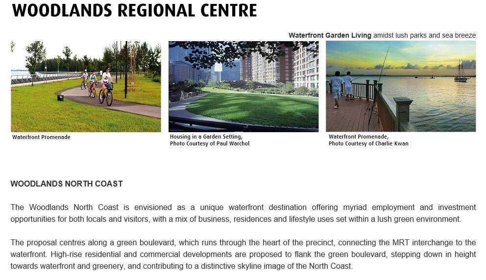
14 WOODLANDS REGIONAL CENTRE : 4 Key Strategies a. Creating Transit-Oriented Developments With the upcoming completion of two Thomson Line MRT stations in 2019 and a planned future Rapid Transit (RTS) Link to Johor, New developments around the existing Woodlands MRT and Bus Interchange, as well as the new Thomson Line stations at Woodlands and Woodlands North will be planned to be highly walkable and wellintegrated with transit nodes to provide greater convenience for the public. b. Creating Distinctive District With about 100 ha of available land for development, there is opportunity to capitalise on its unique location and assets to create a waterfront destination, and lifestyle hub. There are two distinct precincts planned Woodlands North Coast Woodlands Central


15 c. Capitalising on the Waterfront Plan to extend the existing waterfront and enhance connectivity to the waterfront. The proposal centres along a green boulevard, which runs through the heart of the Woodlands North Coast precinct, connecting the MRT interchange to the waterfront. d. Enhancing Connectivity and Green Network This could include connecting to the 150- km Round Island Route and Rail Corridor to establish islandwide and intra-town connectivity. The implementation plans for the Round Island Route and Rail Corridor are currently under study.
16


17 WOODLANDS CENTRAL Woodlands Central is envisioned as a walkable, pedestrian-centric regional retail hub serving the surrounding residents as well as those in the North Region. Running through the heart of the precinct is a pedestrian mall. It connects to the MRT/bus interchange and provides a key focal point for shopping and community events. The pedestrian mall is planned to be flanked by low-rise commercial developments with activities on the first storey to create an intimately-scaled and unique street experience.


18 Disclaimer This compilation of images and content is prepared for the purpose of marketing housing development and projects in Sengkang. While every reasonable care has been taken to ensure the accuracy of contents, the SLP agent cannot be held responsible for any content inaccuracy and/or investment loss arising from it. Source: 1. Woodlands- Wikipedia 2. URA Draft Master Plan 2013 for Woodlands Heng Tai CEA # R014183Z HP: Compiled by Singapore Executive Condominium
ELMVALE ACRES SHOPPING CENTRE MASTER PLAN
 ELMVALE ACRES SHOPPING CENTRE MASTER PLAN Contents 1.0 INTRODUCTION... 2 2.0 LOCATION... 2 3.0 EXISTING CONTEXT... 2 4.0 VISION & GUIDING PRINCIPLES... 2 5.0 LAND USE AND BUILT FORM... 4 5.1 St. Laurent
Building out the Regional Growth Strategy in Surrey: a Strong Centre & a Connected Transit City
 Building out the Regional Growth Strategy in Surrey: a Strong Centre & a Connected Transit City Surrey in the Metro Vancouver Region Regional Growth Strategy identifies Surrey as a major provider of housing
Pioneering the Sustainable Future of Pakistan. A New Destination of Islamabad
 Pioneering the Sustainable Future of Pakistan A New Destination of Islamabad A New Destination of Islamabad C A P I TAL S M A R T CIT Y ISL A M A B A D, PAKISTA N CAPITAL SMART CITY ISLAMABAD C A P I TAL
DOMINION BOULEVARD CORRIDOR STUDY AND ECONOMIC DEVELOPMENT STRATEGIC PLAN A MODEL FOR CHESAPEAKE S FUTURE
 DOMINION BOULEVARD CORRIDOR STUDY AND ECONOMIC DEVELOPMENT STRATEGIC PLAN A MODEL FOR CHESAPEAKE S FUTURE Overview I. Draft Plan Process II. Draft Plan Overview a. Market Analysis b. Master Land Use Plan
Town Center. Block 5 Existing multifamily residential units are expected to remain.
 Area Guidelines Germantown s districts should be developed as distinct communities with unique features that are supported through the guidelines. The guidelines not only help distinguish these districts
10.0 Open Space and Public Realm
 10.0 Open Space and Public Realm 10.0 Open Space and Public Realm The Public Open Space System is comprised of: outdoor spaces available for public use that are either publicly owned (e.g., parks and
DRAFT. Waterfronts and Open Spaces. 10 The Riverfront Open Space System
 CHAPTER 4 Waterfronts and Open Spaces 10 The Riverfront Open Space System 12 Planned, proposed and envisioned riverfront recommendations. Figure 4.3.23 The riverfront will become a major new public amenity
Comprehensive Plan Advisory Panel Meeting #3
 Comprehensive Plan Advisory Panel Meeting #3 November 7, 2016 Agenda 1. September 19 th Meeting Notes 2. Summary of Focus Areas Charrette 3. Heart of the City Focus Area a. HOC2/Station Areas Concept &
GREENBANK DEVELOPMENT MASTERPLAN
 DEVELOPMENT MASTERPLAN POTENTIAL TRAIN STATION COMMUNITY CENTRE Greenbank will be a connected masterplanned community providing easy access to local and surrounding amenity. Affordable quality homes, green
TSAWWASSEN TOWN CENTRE REDEVELOPMENT BLOCK A 004
 Current Context The context for the project includes storey multi-family residential to the northwest, a TD bank immediately north, highway oriented commercial to the east, a surface parking lot to the
3.3. Urban Structure Defining a New Hierarchy of Routes and Spaces >Images
 Section 3.0 I The Masterplan Framework 18 >Images Examples of high quality routes and spaces 3.3. Urban Structure The success of any masterplan lies in a clear definition of the future urban structure
Subarea 4 Indian Creek. Vision The combination of park networks and transportation amenities make Subarea 4 the greenest hub in the Corridor.
 indian creek 180 extends south from 101st Street to I-435. The I-435 and Metcalf intersection is one of the primary intersections in the Kansas City Metro Area. The area includes several residential neighborhoods
Introducing Uptown, Al Zahia s vibrant urban destination
 1 Introducing Uptown, Al Zahia s vibrant urban destination 1 WELCOME TO AL ZAHIA Al Zahia embodies a vision to create a progressive community that s ingrained with Sharjah s traditional values and lifestyle.
YONGE STEELES CORRIDOR SECONDARY PLAN. Young + Wright / IBI Group Architects Dillon Consulting Ltd. GHK International (Canada) Ltd.
 Ltd.") PART A: PREAMBLE 1.0 PURPOSE The purpose of this Secondary Plan is to provide a development framework for intensification of the Yonge/ Steeles corridor including the north side of Steeles Avenue West
PART A: PREAMBLE 1.0 PURPOSE The purpose of this Secondary Plan is to provide a development framework for intensification of the Yonge/ Steeles corridor including the north side of Steeles Avenue West
4 C OMMUNITY D ISTRICTS
 4 C OMMUNITY D ISTRICTS N ew development in the Area will include many different types of land uses, including a destination retail area that attracts people from all over the region; recreation opportunities
Create a connected ecological network. Connect districts with transit. Let the centre define the community
 District A - D Southeast False Creek A 1 A 2 A 3 A 4 Create a connected ecological network Connect districts with transit Let the centre define the community Provide a variety of affordable housing types
Corridor Vision. 1Pursue Minnehaha-Hiawatha Community Works Project. Mission of Hennepin County Community Works Program
 1Pursue Minnehaha-Hiawatha Community Works Project Minnehaha-Hiawatha Community Works is a project within the Hennepin Community Works (HCW) program. The mission of the HCW program is to enhance how the
Complete Neighbourhood Guidelines Review Tool
 Complete Neighbourhood Guidelines Review Tool Prepared By: City of Regina Planning Department October 2014 Page 1 of 14 Community Development Review Checklist for Secondary Plans and Concept Plans The
Overview of Land Use Framework for Victoria Harbourfront. Planning Department February 2011
 Overview of Land Use Framework for Victoria Harbourfront Planning Department February 2011 Background TPB set out Vision Statement for the Victoria Harbour in 1999 To make Victoria Harbour attractive,
Sustainable City of the Future LUSAIL
 Sustainable City of the Future March 2013 1 2013 - Lusail Real Estates Development Company 2 CITY Lusail City Vision To build a strong social and cultural foundation into a technologically advanced modern
PROGRAM: A mixed-use (retail, residential, commercial) infill project encompassing two blocks and nearly 20 acres of downtown Salt Lake City.
 infill project encompassing two blocks and nearly 20 acres of downtown Salt Lake City.") PROGRAM: A mixed-use (retail, residential, commercial) infill project encompassing two blocks and nearly 20 acres of downtown Salt Lake City. Upon completion in 2012, the site will feature more than 650
PROGRAM: A mixed-use (retail, residential, commercial) infill project encompassing two blocks and nearly 20 acres of downtown Salt Lake City. Upon completion in 2012, the site will feature more than 650
PLAY A CITY OF GARDENS AND WATER
 06 PLAY A CITY OF GARDENS AND WATER 64 65 06 PLAY A CITY OF GARDENS AND WATER Singapore is well known for being a garden city. Today, close to half of Singapore is covered by greenery, and there are thousands
Sub Area 2: Downtown Overland Park
 Downtown 132 2.12 encompasses over 600 acres and extends between 71st Street and 87 th Street including Downtown Overland Park. The area is home to several individual historic sites and structures, including
A Plan for the Heart of the Region: Tukwila, WA
 : Tukwila, WA 1 The Plan orchestrates the Restructuring of a 1,000-acre Regional Shopping Area into a Social and Symbolic for the Region. REGIONAL CONTEXT Downtown Seattle (Metropolitan ) 20 miles Bellevue
Hilltop Town Garden City
 Page 1 of 14 4.1 CITY PLANNING PRECEDENTS Oakridge is a Hybrid of the positive aspects of these urban design strategies that integrate nature within the city: Hilltop Town Garden City Using topography
Seneca Meadows. Block 4 Locate office, technology, and medical development adjacent to I Screen views of garage structures from I-270.
 Seneca Meadows Seneca Meadows has an industrial park in its southern end and a mixed-use employment area planned for the north end. The district benefits from extensive I-270 visibility, stream valley
EAST WERRIBEE EMPLOYMENT PRECINCT PRECINCT STRUCTURE PLAN
 3.2 East Werribee Town Centre East Werribee Town Centre Vision The East Werribee Town Centre will complement the Werribee City Centre in providing an employment, service, retail and entertainment focus
This Review Is Divided Into Two Phases:
 Semiahmoo Town Centre Review The purpose of this review: To review the Semiahmoo Town Centre Concept Plan, originally approved in 1993, to ensure that this centre will continue to serve the needs of South
Integrated Planning for a Sustainable & Compact City: Singapore s Experience
 Integrated Planning for a Sustainable & Compact City: Singapore s Experience World Bank, Washington DC 7 October 2010 Presenter: WONG Kai Yeng Urban Redevelopment Authority, Singapore 1 Singapore Today
[PLANNING RATIONALE] For Site Plan Control and Lifting of Holding Zone By-Law 101 Champagne Avenue. May 23, 2014
![[PLANNING RATIONALE] For Site Plan Control and Lifting of Holding Zone By-Law 101 Champagne Avenue. May 23, 2014](/thumbs/75/71599615.jpg "[PLANNING RATIONALE] For Site Plan Control and Lifting of Holding Zone By-Law 101 Champagne Avenue. May 23, 2014") [PLANNING RATIONALE] For Site Plan Control and Lifting of Holding Zone By-Law 101 Champagne Avenue May 23, 2014 Contents 1.0 Introduction... 2 2.0 Site Context... 2 2.1 Adjacent Uses... 2 Figure 1: Site
[PLANNING RATIONALE] For Site Plan Control and Lifting of Holding Zone By-Law 101 Champagne Avenue May 23, 2014 Contents 1.0 Introduction... 2 2.0 Site Context... 2 2.1 Adjacent Uses... 2 Figure 1: Site
3. Urban Design in the Central Area
 3. Urban Design in the Central Area The Central Area Planning and Design Group assumes the responsibility to promote high quality urban and architectural design in the Central Area, plan and ensure the
MOUNT AVENUE MASTERPLAN WORKING DRAFT NOVEMBER 2006
 MOUNT AVENUE MASTERPLAN WORKING DRAFT NOVEMBER 2006 1 1. OVERALL MASTERPLAN IDENTITY: Dun Dealgan motte and bailey The Dun Dealgan motte and bailey, a national monument, is located to the north east of
ENVISIONING TOMORROW S FORT MYERS BEACH
 ENVISIONING TOMORROW S FORT MYERS BEACH NATURAL ENVIRONMENT... 2-1 MOBILITY... 2-1 TIMES SQUARE... 2-1 AVENUE OF PALMS... 2-2 RESIDENTIAL NEIGHBORHOODS... 2-2 A SECOND MAIN STREET... 2-4 FORT MYERS BEACH,
Isabel Neighborhood Plan: Alternatives
 Isabel Neighborhood Plan: Alternatives Presented by: Lori Parks, Associate Planner February 2, 2015 Agenda 1. Background on BART to Livermore 2. Isabel Neighborhood Plan 3. Alternative Scenarios 4. General
DRAFT ROOSEVELT ROAD. District Recommendations. Figure 5.23 The Roosevelt Road Corridor
 CHAPTER 5 Figure 5.23 The Road Corridor Road will develop as a mixed-use corridor, emphasizing regional retail, west of the river and mixed-use development east of the river. KEY RECOMMENDATIONS 1. High
GOLDEN MILE SECONDARY PLAN. Community Consultation Meeting #3 June 26, 2018
 GOLDEN MILE SECONDARY PLAN Community Consultation Meeting #3 June 26, 2018 Meeting Overview 1. Introduction 2. Principles + Vision 3. Street + Block Alternatives 4. Parks + Open Space Alternatives 5. Land
hermitage town center
 hermitage town center A Community Vision prepared by Strada for The City of Hermitage and The Mercer County Regional Planning Commission January 2007 table of contents introduction 3 design principles
Moody Centre Station TOD Area Today
 Moody Centre Station TOD Area Today WHAT IS a transit-oriented Murray Street development area? A Transit-Oriented Development (TOD) Area is a dense, walkable residential and commercial area built to support
Four Big Ideas. Three Key Opportunities. Principles. Draft Place Making Master Plan. 1. The Foreshore 2. Green Links. 3.
 project background Four Big Ideas 1. The Healthy Thriving Place. An International Focus 3. Reclaiming Mooloolaba 4. The Resort Heart of the Coast In November 01 a big ideas workshop was held involving
It takes generations of values to build value for generations.
 It takes generations of values to build value for generations. The Tembusu bears all the hallmarks of a home that is of exceptional value to you and your family, for generations to come. Thoughtful design,
WATERFORD Plan of Preservation, Conservation and Development Supplement Part 1 - Policy Element
 WATERFORD 2012 Plan of Preservation, Conservation and Development 2015 Supplement Part 1 - Policy Element Effective June 11, 2015 2015 Plan Update GOAL To respond to the evolving land use needs and continually
PROPOSED REDEVELOPMENT OF THE GLEN ABBEY GOLF CLUB. STREETSCAPE DESIGN STUDY (excerpt from the Urban Design Brief) TOWN OF OAKVILLE.
 TOWN OF OAKVILLE.") PROPOSED REDEVELOPMENT OF THE GLEN ABBEY GOLF CLUB STREETSCAPE DESIGN STUDY (excerpt from the Urban Design Brief) TOWN OF OAKVILLE OCTOBER, 2016 for 2.4.2 STREETS Streets are the single largest component
PROPOSED REDEVELOPMENT OF THE GLEN ABBEY GOLF CLUB STREETSCAPE DESIGN STUDY (excerpt from the Urban Design Brief) TOWN OF OAKVILLE OCTOBER, 2016 for 2.4.2 STREETS Streets are the single largest component
12600 S Existing Conditions
 STUDY AREA BOUNDARY Study Area Boundary Study Area Context The District Riverton Meadows Vista Station Mountain View Village Market Center 2 Mile Radius 12600 S Existing Conditions 12600 S is a river of
St. Louis Park Wooddale LRT Station Site development guidelines
 St. Louis Park Wooddale LRT Station Site development guidelines November 2013 OVERVIEW St. Louis Park s convenient location as a neighbor to Minneapolis means you re only minutes away from some of the
Oakridge Redevelopment: New Park Concept Overview and Phase 1 Engagement Results
 Oakridge Redevelopment: New Park Concept Overview and Phase 1 Engagement Results REPORT REFERENCE Regular Park Board Meeting Monday, February 19, 2018 Purpose of Presentation To provide the Board with
Make park life, part of your life.
 Make park life, part of your life. A shared spirit of community. The centre of family life. Imagine a friendly, welcoming community where sports, and social gatherings. Where tree-lined Baldivis Parks
Small Area Plan. South Gateway
 Small Area Plan Adopted May 12, 2008 South Gateway Purpose. The South Gateway Small Area Plan defines the City s expectations for the future of the southern entrance to the City at Interstate 85 and Highway
Plan Framework Report. Attachment A
 Plan Framework Report Attachment A Uptown-Douglas Corridor Plan - Plan Framework Report Contents Introduction... 1 Planning Process... 3 Project Objectives... 4 Vision... 5 Community Values... 6 Structural
Contents of Part 6. Part 6 Zones
 Contents of Part 6 Part 6 Zones... 6-1 6.1 Preliminary... 6-1 6.2 Zone codes... 6-3 6.2.1 Low density residential zone code... 6-3 6.2.1.1 Application... 6-3 6.2.1.2 Purpose and overall outcomes... 6-3
REDLANDS TRANSIT VILLAGES SPECIFIC PLAN
 REDLANDS TRANSIT VILLAGES SPECIFIC PLAN CITY COUNCIL STUDY SESSION JANUARY 4, 2019 Redlands Blvd. Eureka St. Orange St. State St. Citrus Ave. Vine St. GENERAL PLAN TRANSIT VILLAGES WE ARE HERE SPECIFIC
SQUAMISH 2010 AND BEYOND COMMUNITY VISION
 Our plan has been imagined and created to be both pragmatic and visionary. At the core of the strategy is a consideration of the highway s role and its impact on the community. First and foremost in creating
The Cambie Corridor 2015 Fall workshop series. What we heard WORKSHOP OUTLINE
 The Cambie Corridor 2015 Fall workshop series W 16 AVE Area 5 CAMBIE CORRIDOR Phase 3 What we heard ovember 21, 2015, 9am-noon, 1:30-4:30pm Peretz Centre 89 Participants* WORKSHOP OUTLIE Introductions
Chairman and Members of the Planning and Development Committee. Thomas S. Mokrzycki, Commissioner of Planning and Building
 LA.09.TOR (Toronto) DATE: TO: FROM: SUBJECT: Chairman and Members of the Planning and Development Committee Thomas S. Mokrzycki, Commissioner of Planning and Building Central Waterfront Secondary Plan
City of Farmington. Downtown Plan. Amendment to the 1998 Master Plan Adopted October 11, 2004
 City of Farmington Amendment to the 1998 Master Plan Adopted October 11, 2004 Introduction Planning Background 1 Scope and Components of the Plan Amendment 2 Concept Introduction 3 Plan Concepts 3 Conceptual
A Neighborhood (Residential, Employment, or Mixed Use) has two components: a Center and a walkable area surrounding the Center.
 has two components: a Center and a walkable area surrounding the Center.") 6INFO SHEET There are two Place Types in the Neighborhood Model: Places organized around a Center, called Neighborhoods, and Places without a Center, called Districts. The Neighborhood Model focuses on
6INFO SHEET There are two Place Types in the Neighborhood Model: Places organized around a Center, called Neighborhoods, and Places without a Center, called Districts. The Neighborhood Model focuses on
Mariposa Lakes. Planned Community. Project Overview. Stockton, CA
 Planned Community Stockton, CA Project Overview March 2007 Summary of Proposed Community is a master-planned community proposed for development on approximately 3,810 acres in southeast Stockton. In 2004,
Michigan City Alternative Analysis Realignment Study. Progress Status Update Report Presentation to City Council February 1, 2012
 Michigan City Alternative Analysis Realignment Study Progress Status Update Report Presentation to City Council Project Web Site Project Web Site is Active www. emichigancity.com Click on NICTD logo at
SFMTA PHELAN LOOP AND PUBLIC PLAZA PHELAN OCEAN AVENUE
 SFMTA Municipal Transportation Agency Image: a bus in front of the Palace of the Legion of honor SFMTA PHELAN LOOP AND PUBLIC PLAZA PHELAN AVENUE @ OCEAN AVENUE Community Meeting May 23, 2012 San Francisco,
The Master Plan Framework
 The Master Plan Framework The East Harbour Master Plan advances the development of 60 acres of former industrial lands east of the Don River. The Master Plan outlines a vision for a vibrant, transit-oriented
THE 355/270 CORRIDOR:
 THE 355/270 CORRIDOR: Strategic Ideas for Sustaining a Livable Work Place Project Summary ACCESS LIFE DESIGN HEALTH WORK Montgomery County Planning Department The Maryland-National Capital Park and Planning
One Bangkok, Thailand s largest integrated development, set to transform Bangkok city-centre and become a new global landmark destination
 For Immediate Release 3 April 2017 (edited 2 May 2018) One Bangkok, Thailand s largest integrated development, set to transform Bangkok city-centre and become a new global landmark destination TCC Group
7.2.9 Eudlo local plan code
 7.2.9 local plan code 7.2.9.1 Application (1) This code applies to assessable development:- (a) within the local plan area as shown on Map ZM29 contained within Schedule 2 (Mapping); and (b) identified
A Vision Statement. In Progress
 A Vision Statement A Vision Statement A vibrant, multicultural, walkable neighbourhood comprised of distinct areas, each with its own special character. A Vision Statement A vibrant, multicultural, walkable
3.5 Principle 5/Response
 5 Principle 5/Response Existing street network Proposed street network Pedestrian street hierarchy Existing streets Existing Regional Arterial 4 Existing Street Network Existing and proposed streets Indicative
IMAGINE CLEARWATER. Community Workshop 3. November 2016
 IMAGINE CLEARWATER Community Workshop 3 November 2016 Imagine Clearwater has been a 6-month community-focused process to re-envision the downtown waterfront. VISIONING FRAMEWORK MASTER PLAN HOW CAN WE
DRAFT Land Use Chapter
 Stevens Creek Urban Village DRAFT 1 18 17 Land Use Chapter INTRODUCTION This Land Use Chapter describes how the Stevens Creek Urban Village will accommodate the growth that is planned for it in the Envision
Final Master Plan and Development Control Regulations
 1. INTRODUCTION CHECK LIST a. Introduction b. Table of contents c. Definitions. d. scope of works. 2. FINAL OVERALL MASTER PLAN a. SITE ANALYSIS and OVERVIEW: i. Existing and Proposed Site Plan Levels.
Introduction. Intent of the Plan. Urban Design and Land Use Approach
 Introduction Intent of the Plan This is the Second Public Open House for the. The intent of the is to update current City policy in order to encourage future development that will ensure a diverse, lively,
Comprehensive Plan & Station Area Zoning
 Village of Tarrytown Comprehensive Plan & Station Area Zoning Public Workshop November 5, 2017 Warner Library WXY architecture + urban design Pace University - Land Use Law Center George M. Janes & Associates
Making Nature Areas More Accessible - Northern Wetlands
 1 RESPONSES TO SUBJECT GROUP (SG) ON PARKS & WATERBODIES PLAN Making Nature Areas More Accessible - Northern Wetlands Provide new nature parks next to Sungei Buloh mangroves. Allow camping near the mangroves.
PARKWAY FOREST RE-URBANIZATION: EMERALD CITY
 PARKWAY FOREST RE-URBANIZATION: EMERALD CITY PUBLIC ART PLAN El-Ad Group (Canada) Inc. Prepared by: Public Art Management For Presentation to the Toronto Public Art Commission, February 2010 1 1.0 Introduction
CITY OF TARPON SPRINGS DCA#11-1AR
 Agenda Item #3.H.2 05/09/11 TAMPA BAY REGIONAL PLANNING COUNCIL LOCAL GOVERNMENT COMPREHENSIVE PLAN ADOPTED AMENDMENT REPORT CITY OF TARPON SPRINGS DCA#11-1AR 1 ADOPTED WITH THE FOLLOWING CHANGES: Ordinance
City Center Neighborhood Plan
 [1] City Center Neighborhood Plan As adopted by Ordinance No. 2014-09-049 and amended by Ordinance Nos. Formerly CBD Neighborhood as adopted by Ordinance No. 8868 and amended by Ordinance Nos. 8946, 9693,
2.0 Urban Design Concepts
 0 Urban Design Concepts Urban Design Concept diagrams The Waterfront Axis The Park Axis The Wharf Axis Waterfront Precincts 0.1 The Four Key Concepts: This Concept for the Wynyard Quarter establishes four
Deicke Richards Aug 2009 Rev A. Varsity Station Village A master plan for a TOD
 Deicke Richards Aug 2009 Rev A Varsity Station Village A master plan for a TOD Introduction The Varsity Station Village project is transforming empty governmentowned industrial land on Queensland s Gold
Lehigh Acres Land Development Regulations Community Planning Project
 Lehigh Acres Land Development Regulations Planning Effort Summary In July, 2010 Commissioner Frank Mann invited the Lehigh Acres community to start discussing how to achieve their recently adopted community
burlington mobility hubs study Downtown Burlington Mobility Hub
 burlington mobility hubs study Downtown Burlington Mobility Hub Draft Precinct Plan Workbook PIC #3, September 7, 2017 downtown mobility hub objectives City staff and their consultants are proposing an
LAKEVIEW VILLAGE VISION & MASTERPLAN PRESENTATION TO CITY OF MISSISSAUGA. April 9, 2018
 LAKEVIEW VILLAGE VISION & MASTERPLAN PRESENTATION TO CITY OF MISSISSAUGA April 9, 2018 AGENDA Introduction Vision Plan Comparison The Big Moves Trail Connections Plan Overview Districts Conveyance Comparison
Shared Principles and Emerging Plan Directions
 Shared Principles and Emerging Plan Directions Introduction Since the Fairfield Neighbourhood planning process launched in June 2016, we have heard from many residents, businesses, groups and other people
INTRODUCING THE BALTIMORE CITY GREEN NETWORK VISION PLAN
 INTRODUCING THE BALTIMORE CITY GREEN NETWORK VISION PLAN GOALS OF THE GREEN NETWORK PLAN Protect and enhance the unique ecological resources of our city Support economic growth and sustainable redevelopment
Chapter 2: OUTLINE PLANNING APPLICATION PROPOSALS. A New Garden Neighbourhood Matford Barton 17
 Chapter 2: OUTLINE PLANNING APPLICATION PROPOSALS A New Garden Neighbourhood Matford Barton 17 2.1. SUMMARY AND STATUS OF THE PROPOSALS 2.1.1. The parameter plans and associated wording in this chapter
WELCOME and introduction
 1 WELCOME and introduction Mobility Hub Locations within Burlington STUDY OVERVIEW STUDY OBJECTIVES The City of Burlington is developing four Area Specific Plans, one for each of Burlington s Mobility
the west loop HOME TO 5,000 NEW DOGS
 the west loop the west loop HOME TO 5,000 NEW DOGS the west loop HOME TO 5,000 NEW DOGS AND 20,000 NEW RESIDENTS outline: the west loop now the vision how do we get there? opportunity LEVERAGE TRANSIT
11.5 Kipling Avenue Corridor Secondary Plan
 11.5 Kipling Avenue Corridor Secondary Plan ADOPTED BY VAUGHAN CITY COUNCIL NOT YET APPROVED BY THE ONTARIO MUNICIPAL BOARD 11.5.1 Development Principles and Objectives The following principles support
Description of Preferred Alternative
 Chapter 2 Description of Preferred Alternative 2.1 Introduction This chapter of the programmatic Sammamish Town Center Sub-area Plan Final EIS provides a more detailed description of the Preferred Alternative
Prosperity Hucks Area Plan. Transportation and Planning Committee May 11, 2015
 Prosperity Hucks Area Plan Transportation and Planning Committee May 11, 2015 Presentation Outline 1. Background and Location 2. Community Dialog Process 3. Activity Center Recommendations 4. Wedge Recommendations
NORTH CLAYMONT AREA MASTER PLAN COMMUNITY WORKSHOP #1 FEBRUARY 3, 2016
 NORTH CLAYMONT AREA MASTER PLAN COMMUNITY WORKSHOP #1 FEBRUARY 3, 2016 1. Introduction To the team and to the Plan Planning Partners The Claymont Community WILMAPCO New Castle County Claymont Renaissance
THE NEIGHBORHOOD TODAY
 THE NEIGHBORHOOD TODAY CORE AREA VISION How are we Good Urbanism A Site s DNA thinking about Elements of great Unique elements urban communities embedded in a place the site and design? ELEMENTS LIKE:
Figure 1- Site Plan Concept
 Figure 1- Site Plan Concept Parking will be provided underground on three levels at rate of 1.0 space/ unit; this rate includes all visitors parking. MMM Group has prepared a parking assessment (April,
178 Carruthers Properties Inc.
 178 Carruthers Properties Inc. Planning Rationale for 178 Carruthers Avenue Site Plan Control Application June 2014 Table of Contents 1.0 Introduction 2.0 Overview of Subject Property 3.0 Current Zoning
What Pioneer Grove Will Look Like?
 The City of Deerfield Beach has embarked on a journey to create a new town center within the old heart of Deerfield Beach. The new town center is known as Pioneer Grove. Pioneer Grove will be Everybody
North Oakville East Parks Facilities Distribution Plan. November, 2009
 North Oakville East November, 2009 POLICY CONTEXT 1) Purpose a) The purpose of this document is to be a guide for the location, configuration, design and development of the parks system for the North Oakville
TOWN COUNCIL / PLANNING COMMISSION
 Workshop #3 TOWN COUNCIL / PLANNING COMMISSION January 20, 2011 Consultant Team In Attendance Tonight BMS Design Group Nevada City and San Francisco Michael Smiley, AICP, ASLA Partner-in-Charge Nancy L.
BE PART OF THE CHANGE life works here.
 BE PART OF THE CHANGE life works here. A NEW DESTINATION FOR URBAN LIVING IN CALGARY Experience UNIVERSITY DISTRICT. A new quality of life community that will change the way you experience the city. Architecturally
EcoVerde MADISON TO DOWNTOWN TO BEACH. Legend Highway Major Connection Major Street Local Street Proposed Access. Response to Tropicana Field RFP
 EcoVerde TO BEACH 275 16th Street North 16th Street South 13th Street North 13th Street South 11th Street North 11th Street South 1st Avenue North Central Avenue 1st Avenue South TO DOWNTOWN 2nd Avenue
Sustainably Repositioning Greyfield Sites. Greyfield Sites Anywhere
 Sustainably Repositioning Greyfield Sites Jim Constantine Looney Ricks Kiss Architects Todd Poole 4ward Planning Greyfield Sites Anywhere Pennsylvania Chapter American Planning Association Conference 2009
P.T. AGUNG PODOMORO Villa Serpong Resort
 P.T. AGUNG PODOMORO Villa Serpong Resort 1 DRAFT #4 (AND FINAL) Newton's Pty Ltd VIDEO DOCUMENTARY SCRIPT VISION 1 Reflection on the river of a boatman, poling his bamboo raft. A herd of cattle swim in
SECTION ONE: INTRODUCTION. introduction
 introduction 1 INTRODUCTION Since it was first established in 1843 as a trading post for the Hudson s Bay Company, Victoria has evolved into a Provincial capital city that is recognized across Canada and
Task Force on Kai Tak Harbourfront Development. Station Square at Kai Tak
 For discussion on 24 February 2017 Station Square at Kai Tak PURPOSE This paper seeks Members views on the design of the Station Square at Kai Tak. BACKGROUND 2. Upon the relocation of the Hong Kong International
CONTEXT: the Highway, the River + the Railroads run through us.
 CONTEXT: the Highway, the River + the Railroads run through us. I-25 36 In the past they have divided us, now we have an opportunity to unite us. I-76 I-270 I-76 CSU I-25 LEGEND Cut + Cover River North