BENSON / HUNT TERTIARY PLAN
|
|
|
- Darcy Harrison
- 6 years ago
- Views:
Transcription
1
2 BENSON / HUNT TERTIARY PLAN
3 TABLE OF CONTENTS 1.0 INTRODUCTION 1.1 Purpose How to Read This Plan Tertiary Plan Context Vision and Principles Public Consultation PLANNING CONTEXT 2.1 Official Plan Zoning By-law Summary/Conclusion PHYSICAL CONTEXT AND CHARACTER 3.1 Pattern/Form of Residential Development Streetscape Design/Landscaping Neighbourhood Character Levendale Road Lucas Street Mill Street Mill Walk Court Hall Street Benson Avenue Hunt Avenue Existing Medium Density Residential Development Summary/Conclusion URBAN DESIGN GUIDELINES 5.1 Built Form Criteria Facades Building Height and Setbacks Unit Width and Lenght Garages and Driveways Front Entries and Steps Corner Lots Materials and Design Elements Landscape and Grading Criteria Criteria for Transition Area s Lucas Street Transition Hall Street Transition Built Form Typologies Single-detached Dwelling Semi-detached Dwelling Street Townhouse Dwelling Rear Lane Townhouse Dwelling Front Lane Townhouse Dwelling IMPLEMENTATION 6.1 Pre-Application Meetings Site Plan Control Concept Plan and Urban Design Zoning By-Law 59 SCHEDULES A B Study Boundary Development Concept 4.0 TERTIARY PLAN 4.1 Land Use Directions Low-Density Area Medium-Density Area Transition Area 42 TOC TABLE OF CONTENTS JUNE 2013
4 BENSON / HUNT TERTIARY PLAN
5 1.0 INTRODUCTION JUNE
6 1.0 INTRODUCTION Guided by the community vision articulated in the Official Plan (OP), and building on the principles of compatible development, the objective of the Benson/Hunt Tertiary Plan is to provide direction for the development of future residential uses that recognize and enhance the unique character of the neighbourhood. As part of an older neighbourhood in the Town of Richmond Hill, the Benson/Hunt Tertiary Plan area is distinguished by a combination of older homes on relatively large lots, mature tree-lined streets and significant open areas of landscape. Several homes in the area have also been identified as architecturally and historically important. Over time, the Benson/Hunt area has continued to evolve, change and mature, with the construction of both new buildings and replacement buildings. The incremental pattern of development activity, accompanied by a diversity of building form, type and scale, have resulted in a visually rich and interesting neighbourhood character - a unique feature that should be embraced and reinforced. The recent development of medium-density residential uses, primarily along Benson and Hunt Avenues, has posed a number of challenges to maintaining the characteristics that define this neighbourhood. In this area, existing lots have been subdivided to allow for the development of townhouses which, with smaller units and more driveways, have reduced the amount of landscaped area overall, the ability to maintain and create treelined streets and the opportunity for on-street parking. Moreover, the designs of these buildings are not in keeping with that of the neighbourhood. To address these challenges, and in accordance with the policies of the Official Plan, the Benson/Hunt Tertiary Plan has been undertaken to provide clarity and certainty as to where and how development may take place in the Tertiary Plan area over the long term. The Tertiary Plan draws from the planning and policy context, the challenges presented by medium-density forms of development, feedback from the public engagement process, a character review and analysis of the area and fundamental principles of good planning and urban design. 1.1 PURPOSE a) The purpose of the Benson/Hunt Tertiary Plan, as set out in the policies of the Official Plan, is to determine appropriate locations for medium-density residential development and to establish area-specific design criteria to guide development within the Tertiary Plan area. b) It is the intent of the Tertiary Plan to provide certainty on where and how mediumdensity development may occur within the Tertiary Plan area. At the same time, the Tertiary Plan identifies where low-density residential areas are to be protected and where and how transitions between medium-density and low-density development is to occur. c) Development, including in the transition areas, will be subject to site-specific design criteria. d) The Tertiary Plan aims to allow a variety of housing types and forms to coexist where appropriate, while enhancing the unique character of the neighbourhood and promoting design excellence in the private and public realms. 2 BENSON / HUNT TERTIARY PLAN

 Physcial Context and Character, which provides an overview of the Tertiary Plan area with respect to the existing pattern of development, built form and streetscape design.")
 The boundary of the Tertiary Plan area is identified on Schedule A.")
7 1.2 HOW TO READ THIS PLAN The Benson/Hunt Tertiary Plan consists of four main parts; these include: a) The Tertiary Plan Context, which describes the area of the Tertiary Plan, the vision and principles that have guided its development and the process by which the public have had the opportunity to provide their input. b) The Planning Context, which describes the policy and zoning framework for the Tertiary Plan. c) Physcial Context and Character, which provides an overview of the Tertiary Plan area with respect to the existing pattern of development, built form and streetscape design. d) The Tertiary Plan, which, based on the context, provides land use and built form directions for future development in the area. 1.3 TERTIARY PLAN CONTEXT a) The boundary of the Tertiary Plan area is identified on Schedule A. The boundary reflects the physical context and built form of the neighborhood in relation to the policies of the Town s Official Plan. A review of the history of the area and past development pressures was undertaken to understand the patterns of development in the area and the changes that have occurred gradually over time. b) The Benson/Hunt Tertiary Plan area is located in the neighbourhood west of the Downtown Local Centre. The Tertiary Plan area generally includes the lots fronting onto Levendale Road, Hunt Avenue, Benson Avenue, Mill Walk Court, Mill Street, Lucas Street and Hall Street, as shown on Schedule A. Mill Street - tree canopy c) Designated collector streets in the Tertiary Plan area include Mill Street and the portion of Hall Street between Mill Street and Wright Street. For this reason the southern portion of the of the study area was included in accordance with the Official Plan. d) Designated local streets in the Tertiary Plan area include Levendale Road, Benson Avenue, Hunt Avenue, Lucas Street, Hall Street and Mill Walk Court. e) The character, identity and heritage attributes of the Benson/Hunt Tertiary Plan area shall be reinforced through appropriate height, massing, and architectural detailing of built form and appropriate landscaping and streetscaping elements. As such, all new development within the Benson and Hunt Area shall be evaluated on the basis of the principle of compatible development, meaning that: Existing dwelling Compatible new development should represent a good fit within the physical context and character of the surrounding area. f) The Tertiary Plan establishes urban design guidelines with respect to built form, transition, site planning, landscaping and grading criteria recommended to guide all forms of residential development in the area. g) It is intended that the Benson/Hunt area be developed in accordance with the policies of this Tertiary Plan in conformity with the Official Plan and in conjunction with the Zoning By-law of the Town of Richmond Hill. h) The following text and maps, identified as Schedule A Study Boundary and Schedule B Tertiary Plan, attached hereto, constitute the Benson and Hunt Area Tertiary Plan. Urban tree canopy JUNE

8 4 BENSON / HUNT TERTIARY PLAN Schedule A - Tertiary Plan Boundary


 Connectivity and Mobility - Plan for transit and pedestrian-oriented development and Promote connectivity, mobility and accessibility within and")
9 1.4 VISION AND PRINCIPLES The Benson/Hunt Tertiary Plan is guided by the following vision and principles established in the Official Plan: a) Compatibility - Development shall be compatible with the character of the adjacent and surrounding area in accordance with the policies of the Official Plan and subject to criteria as set out in an Infill Plan or Tertiary Plan, as approved by Council. b) Place-making to recognize the unique aspects of the neighbourhood, understand its existing attributes and how they combine to create a defined character, including: The variety of building types and styles; Buildings of historic or architectural quality; The character of the adjacent Downtown Local Centre; The predominance of mature trees and mixed forest character; and, Pedestrian-scaled development. Block townhouse development on Benson Avenue c) Connectivity and Mobility - Plan for transit and pedestrian-oriented development and Promote connectivity, mobility and accessibility within and between neighbourhoods, including: Creating pedestrian-oriented and pedestrian-scaled streets; and, Providing connections to public transit. d) Urban Design to strive for design excellence in the public and private realm, including: Built form style, massing, design; Patterns of streets, blocks, lots and lanes; Streetscape design, landscaped areas and treatments; and, Pattern of yard setbacks. Diverse built-form 1.5 PUBLIC CONSULTATION a) In keeping with the community engagement strategies established by the People Plan Richmond Hill process, residents were provided the opportunity to participate in the Benson/Hunt Tertiary Plan process. b) The public consultation events were well attended, with resident representation from all of the areas within the Tertiary Plan. c) The feedback received from these events generally addressed issues of building type, building height, building design, building setbacks and landscaping as they relate to the overall character of the community. Tree-lined streets JUNE
10 6 BENSON / HUNT TERTIARY PLAN
11 2.0 PLANNING CONTEXT JUNE
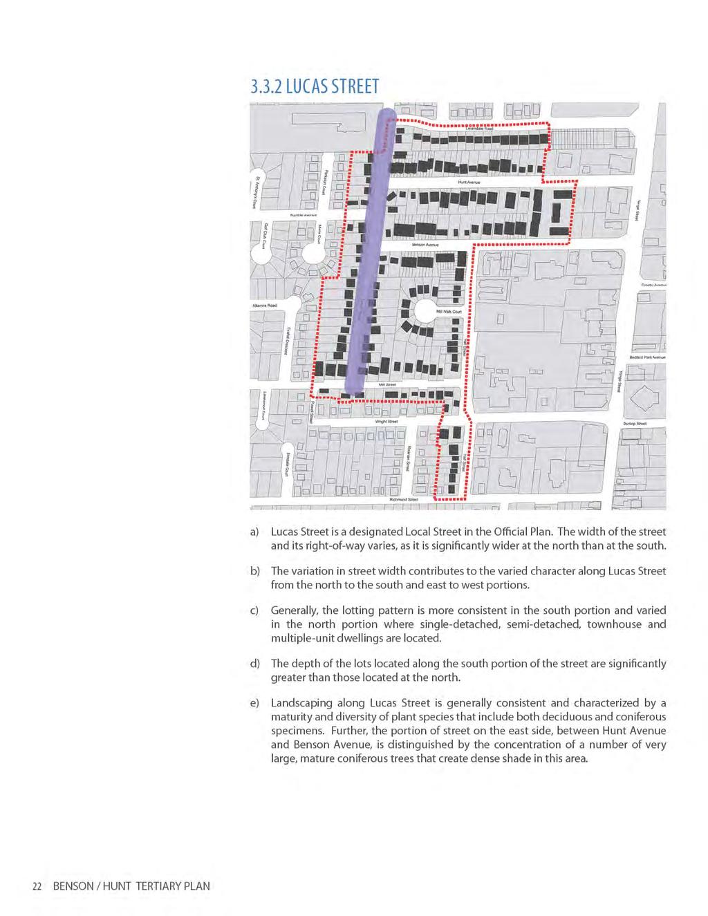
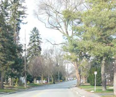
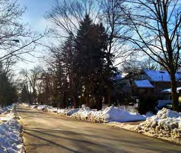
12
13 2.0 PLANNING CONTEXT 2.1 OFFICIAL PLAN a) The Official Plan designates the Benson/Hunt Tertiary Plan area as part of the Neighbourhood designation. Lands to the north, west and south of the Tertiary Plan area are also designated Neighbourhood. Lands to the east are designated Downtown Local Centre. b) Neighbourhoods are characterized by low-density residential areas. Opportunities for small-scale infill development may exist within Neighbourhoods as they evolve over time. c) In the neighbourhood designation, low-density residential uses such as low-rise single detached, semi-detached and duplex dwellings are permitted. d) Medium-density residential uses such as low-rise townhouses and walk-up apartments are also permitted on lands that have frontage on: An arterial street; A collector street and is within walking distance to a public transit stop and as identified in a Tertiary Plan undertaken by the Town and approved by Council; and A local street and only in proximity to an existing medium-density residential development as identified in a Tertiary Plan undertaken by the Town and approved by Council. e) Development shall be compatible with the character of the adjacent and surrounding area in accordance with policy of the Official Plan, which includes: Predominant building forms and types Massing General pattern of streets, blocks, lots and lanes Landscaped areas and treatments General pattern of yard setbacks f) Development wihtin the Neighbourhood designation shall have a maximum building height of 3 storeys, except on an arterial street where the maximum building height shall be 4 storeys. g) Existing buildings greater than 3 storeys which legally existed on the date of adoption of the Official Plan, shall be permitted. New development greater than 3 storeys shall only be permitted in accordance with the policies of this Plan. h) Development shall be assessed on the basis on conformity with the relevant urban design guidelines which have been approved by Council in accordance with the policies of Section of the Official Plan. JUNE


14 10 BENSON / HUNT TERTIARY PLAN Figure 2 / Zoning Map
15 2.2 ZONING The Benson/Hunt Tertiary Plan area is generally a low-density residential area which has experienced incremental change over time. This has generally involved new construction and replacement of single-detached dwellings on lots zoned for such uses. The majority of more recent development, in the last ten years, has been in the form of medium-density street townhouses, which have occured along Benson and Hunt Avenues through site-specific amendments to the Zoning By-law. a) The existing Zoning By-law predates the Official Plan. b) The existing Zoning By-law permits the following residential uses: i. R2 Residential Second Density Zone permits single-detached dwellings; ii. RM1 Residential Multiple First Density Zone permits single-detached dwellings, semi-detached dwellings, and multiple-unit dwellings; iii. RM1-S Residential Multiple First Density Zone permits single-detached and semi-detached dwellings; iv. RM2 Residential Multiple Second Density Zone permits townhouse dwellings and multiple-unit dwellings; v. RM3 Residential Multiple Third Density Zone permits multiple-unit dwellings; vi. R2(RM2) Residential Second Density Zone which permits single-detached dwellings and the uses in the RM2 zone, subject to the provisions of the Zoning By-law. c) The majority of properties in the area are zoned R2, which permits single-detached dwellings. d) Within the Tertiary Plan area, there are two types of circumstances that allow for medium-density development, these are: Lands that are currently zoned for medium-density development and allow for townhouses, but do not have the development standards necessary to implement street-oriented townhouses. Lands that are not zoned for medium-density development but have been developed through site-specific amendments to permit the use and standards. e) Most of the townhouse development which has occurred in the Tertiary Plan area has been by way of site-specific approvals to implement site-specific development standards. f) The area has existing zoning permissions for medium-density in place on certain properties within the Tertiary Plan area, which has led to continued pressure for additional medium-density in the area. 2.3 SUMMARY/CONCLUSION Zoning standards for medium-density development, while in effect on certain lots on Benson and Hunt Avenues, need to be updated in accordance with the new criteria and urban design guidelines set out in this Tertiary Plan which implement the policies of the Official Plan. JUNE
16 12 BENSON / HUNT TERTIARY PLAN
17 3.0 PHYSICAL CONTEXT AND CHARACTER JUNE


18 14 BENSON / HUNT TERTIARY PLAN Figure 3 / Pattern of Residential Development Map


 iv. Block townhouse dwellings (3-storeys) v.")
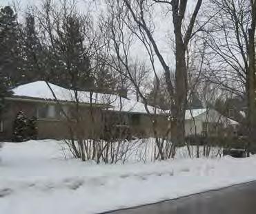
19 3.0 PHYSICAL CONTEXT AND CHARACTER 3.1 PATTERN/FORM OF RESIDENTIAL DEVELOPMENT The Benson/Hunt Tertiary Plan area is generally characterized by a mix of low-rise residential uses consisting mainly of old, new and single-detached and semi-detached dwellings. The lot sizes and the orientation of the homes provide ample space for landscaping and tree planting. One of the neighbourhood defining characteristics that has resulted from this form and pattern of building is the existing tree canopy. a) Within the Benson/Hunt Tertiary Plan area the types of dwellings that exist include: i. Single-detached dwellings (1-storey and 2-storey) ii. Semi-detached dwellings (2-storeys) iii. Townhouse dwellings (2-storeys and 3-storeys) iv. Block townhouse dwellings (3-storeys) v. Multiple-unit dwellings (3-storeys) Single-detached dwelling on Hall Street b) Walk-up style apartments and townhouse dwellings are located within the Tertiary Plan area along Lucas Street, Benson Avenue and Hunt Avenue, in proximity to Yonge Street. c) The age of buildings in the Benson/Hunt Tertiary Plan area range from before 1949 to after 1990, with a number of homes in and around the Mill Street area identified as architecturally and historically important. d) The pattern of development in the Benson/Hunt Tertiary Plan area indicates that a majority of buildings in the area were built prior to the 1960s. e) Redevelopment in the area, including replacement housing, occurred generally in the period between 1960 and This includes single-detached dwellings throughout the area, and the multiple unit dwellings located on the west side of Lucas Street and along Benson and Hunt Avenues. Single-detached dwellings on Hunt Avenue f) The more recent developments in the area include the 2-storey single-detached dwellings on Mill Walk Court, which were created in the 1990 s through an infill plan of subdivision process, and a number of the 2 to 3-storey townhouse dwellings on Benson Avenue, Hunt Avenue and the southwest corner of Hall Street and Benson Avenue, which were implemented through site-specific approvals. Street townhouses on Benson Avenue JUNE


20 16 BENSON / HUNT TERTIARY PLAN Figure 4 / Existing Residential Built Form Map
21 JUNE

 The objectives for streetscaping and landscaping in the area are to reinforce the attributes of the existing vegetation, enhance the urban tree canopy, promote a diverse tree")
 Tree planting and landscaping, particularly along the street line which defines the private/public interface, should reinforce a pedestrian-oriented streetscape.")
22 3.2 STREETSCAPE DESIGN/LANDSCAPING a) Within the Benson/Hunt Tertiary Plan area, the existing vegetation is characterized by a high level of bio-diversity, a significant number of mature trees and large numbers of original plantings. b) The Tertiary Plan area displays a natural community with significant canopy cover and representation of deciduous and coniferous composition. c) The objectives for streetscaping and landscaping in the area are to reinforce the attributes of the existing vegetation, enhance the urban tree canopy, promote a diverse tree population, and utilize native planting stock wherever possible. d) Tree planting and landscaping, particularly along the street line which defines the private/public interface, should reinforce a pedestrian-oriented streetscape. Large setbacks with mature trees e) New development in the Benson/Hunt Tertiary Plan area should incorporate street tree species that reinforce the character fo the area, and in accordance with the Town s Native Trees Selection Guide. Mature trees / urban canopy 18 BENSON / HUNT TERTIARY PLAN


23 3.3 NEIGHBOURHOOD CHARACTER a) Place-making is one of the objectives of the Official Plan, and involves a multifaceted approach to the planning, design and management of public spaces, including streetscapes, in combination with buildings in adjacent private spaces. b) The principles of Place-making are important to the Benson/Hunt Tertiary Plan as a way to understand, recognize, and protect the unique aspects and characteristics of the neighbourhood. They provide the basis for establishing design criteria to guide future development that represents a good fit within the existing context and enhances the characteristics of the neighbourhood. d) The Benson/Hunt Tertiary Plan recognizes the unique aspects and characteristics that, when taken as a whole, set it apart from its surrounding context. The attributes that define the character of the Benson/Hunt Tertiary Plan area include: The pattern and form of residential development that has occurred, and is occurring, in the area; this includes the height, massing, style and setback of buildings and their relationship to one another and to the street. Streetscape design and landscaping, which includes tree-lined, pedestrianoriented streets and large areas of grass lawns and planting. Heritage, which includes the buildings identified as historically important Single-detached dwellings on Hunt Avenue e) The following section provides a character overview of the Tertiary Plan area. Street townhouses on Benson Ave. Single-detached dwellings on Hall Street Walk-up apartments on Hunt Avenue JUNE
24


25 Consistent Lot Size, Height and Massing Consistent Building Forms and Styles Mature Trees Consistent Building Setbacks Lot Pattern is Similar to the Surrounding Area JUNE
26


,")

27 Varied building height and massing Mature street trees Varied building setbacks Varied building forms and lot sizes - multiple-unit dwelling, single-detached dwelling Narrowing street width (south toward Mill Street), and change in character JUNE
28


29 Varied building forms and styles Narrow road width Mature trees frame the street Large setbacks Architecturally and historically import buildings Consistent building form - single-detached dwellings JUNE
30


31 Street trees Consistent lot sizes and setback Consistent building forms and styles, height, and massing JUNE
32


33 Varied lot sizes, building height and massing Block townhouses with underground parking, on east side of Hall Street Fewer trees along the street at the north end More trees along the street at the south end Varied building forms, styles and age of housing Change in character from the north to south JUNE
34


35 Varied building setbacks Wide street width Varied lot sizes, building form, style, height and massing Lack of tree along the street More and mature trees on the north side of the street 2-storey townhouses 3-storey townhouses JUNE
36


37 Adjacent apartment building (in the Downtown Local Centre) Wide street width Varied building forms and styles Walk-up apartment Multi-unit dwelling Single-detached dwelling Mature tree canopy on the south side Lack of tree canopy on the north side JUNE

38 34 BENSON / HUNT TERTIARY PLAN Figure 5 / Existing Medium Density Residential Development Map
39 3.4 EXISTING MEDIUM DENSITY RESIDENTIAL DEVELOPMENT Medium-density housing forms part of the residential character of the Benson/Hunt Tertiary Plan area. a) Medium-density housing forms are concentrated primarily along Benson Avenue and Hunt Avenue and generally in proximity to Yonge Street. b) The forms of medium-density development include street townhouses, block townhouses and walk-up apartments. Most of these have been developed on lots previously zoned for single-detached dwellings and/or on lots where the zoning permits such uses. c) Some of these developments were approved by the Ontario Municipal Board on a site-specific basis, where the need for a Zoning By-law amendment was required to facilitate the development. d) Although not within the Tertiary Plan area, the southeast corner of Benson Avenue and Hall Street has been developed with medium-density housing forms, including street townhouses and block townhouses with underground parking. e) There is continued pressures for this form of development particularly in the areas where they currently exist. 3.5 SUMMARY/CONCLUSION Historically, the pattern and form of development in the Benson/Hunt Tertiary Plan area has been incremental and consisted of mainly 1 to 2-storey single-detached homes sited on relatively large lots. The large landscaped areas afforded by this pattern and form of development created the existing tree canopy and some of the distinctive treelined streets we see today. This diversity of housing, the lotting pattern and the mature trees, are key attributes of the character of this area. Newer development, the majority of which has been in the form of medium-density townhouse dwellings, including street-oriented townhouses, has been focused primarily along Benson and Hunt Avenues. As the existing Zoning By-law does not have the development standards necessary to facilitate these forms of development, most of these medium-density uses have occurred through site-specific amendments to the Zoning By-law. Medium-density development, implemented in this manner, has had an impact on the character of the Tertiary Plan area. They include: a) The loss of street trees as well as the diminished opportunities to plant new street trees. b) Narrow lot frontages and increased numbers of driveways. c) The increased number of driveways have reduced the opportunity for on-street parking at the curb. JUNE
40 d) The overall increase of hard surface paving has reduced opportunities for ground water infiltration and landscaping. e) The predominance of driveways has resulted in less pedestrian-oriented streetscapes. Moreover, new buildings have not recognized the attributes of their neighbours in either form or design, resulting in streetscapes that appear disparate and unrelated to one another and to the street. These concerns were reinforced by residents through the public consultation process. It was noted that the unique attributes of the neighbourhood such as the tree-lined streets, the diversity of buildings, the massing, height and relationship of buildings to one another and to the street, were not being respected by the new developments. In addition to how new developments were to occur, the question of where new development would be located, was also raised. In this regard, the Official Plan sets out the requirements to undertake a Tertiary Plan. The Benson/Hunt Tertiary Plan, involving the analysis of the planning context, the physical context, the character of the neighbourhood, and input from public consultation is intended to guide future development in the area. It provides direction on where development is to occur and on how it is to occur, in a manner that ensures that new development represents a good fit within the existing context of the area and recognizes and enhances the unique character of the neighbourhood. 36 BENSON / HUNT TERTIARY PLAN
41 JUNE
42 38 BENSON / HUNT TERTIARY PLAN
43 4.0 TERTIARY PLAN JUNE


44 40 BENSON / HUNT TERTIARY PLAN Schedule B - Tertiary Plan
45 4.0 TERTIARY PLAN a) The Benson/Hunt Tertiary Plan has been prepared in accordance with the policies of the Official Plan, and should be read and implemented in conjunction with the criteria and urban design policies of this Plan and the policies of the Official Plan. b) The Tertiary Plan provides a framework for future development in the area by identifying locations that permit medium-density residential development, lowdensity residential development, transition areas between the two and establishes design criteria to guide their development to ensure a good fit within the existing context of the surrounding area. 4.1 LAND USE DIRECTIONS a) To provide direction for development in the Tertiary Plan area, including mediumdensity forms of housing and to ensure that development represents a good fit within the existing context of the surrounding area, the Tertiary Plan identifies three distinct areas a Low-Density Area, a Medium-Density Area and transitions areas as shown on Schedule B attached to the Tertiary Plan LOW-DENSITY AREA a) The Low-Density Area is focused along Levendale Road, Lucas Street, Mill Walk Court, Mill Street and the west side of Hall Street, south of Mill Walk Court, refer to Schedule B. b) Within the Low-Density Area, single-detached dwellings are permitted. c) Semi-detached dwellings may also be permitted in the Low-Density Area subject to a Zoning By-law amendment. d) Medium-density dwellings such as townhouses, are not permitted in the Low- Density Area. e) Buildings in the Low-Density Area shall be a maximum 2-storeys in height. Building heights for new development shall be subject to the applicable design criteria in section MEDIUM-DENSITY AREA a) The Medium-Density Area is focused along Benson Avenue and Hunt Avenue, and includes the west portion of Hall Street north of Mill Walk Court. The limits of the Medium-Density Area are the centre-line of the associated streets or the rear lot line adjacent to the Low-Density Area, refer to Schedule B. b) The Medium-Density Area encompasses the lands mainly along Benson and Hunt Avenues, where medium-density residential uses currently exist, within the Tertiary Plan area. c) Within the Medium-Density Area, townhouse dwellings are permitted. In addition, single-detached dwellings and semi-detached dwellings are also permitted in the Medium-Density Area. JUNE
46
47 JUNE
48 44 BENSON / HUNT TERTIARY PLAN
49 5.0 URBAN DESIGN GUIDELINES JUNE
50
51
 To mitigate the impact of driveways on the streetscape, landscaping and tree planting, hard surface pavement should be minimized.")
 Front entries and steps should be integrated into the design of units, with a maximum of 5 steps at the exterior. 5.1.")
 Corner units shall be designed with its main entry at the exterior side yard.")

52 5.1.4 GARAGES AND DRIVEWAYS a) Designs should de-emphasize the garage, with garage doors integrated into the façade of the units. b) To mitigate the impact of driveways on the streetscape, landscaping and tree planting, hard surface pavement should be minimized. c) Street accessed driveways should be paired to minimize interruptions at the street and to maximize landscaped areas for tree planting and landscaping. Integrated garages FRONT ENTRIES AND STEPS a) Front entries and steps should be integrated into the design of units, with a maximum of 5 steps at the exterior CORNER LOTS a) Corner units are visually prominent locations and shall be designed with both facades, visible from the street, of equal importance. b) Corner units shall be designed with its main entry at the exterior side yard. Minimize entry steps c) Building elements such as wrap-around porches and corner features, should be incorporated in the design of corner units MATERIALS AND DESIGN ELEMENTS In the Benson/Hunt Tertiary Plan area the detailing and materials used in the design of new buildings should reflect that of the other homes in the area. a) A variety of coordinated and complementary materials that enhance the character of the neighbourhood is encouraged. b) Design elements that relate to and are compatible with the predominant style of the neighbourhood should be incorporated in new designs. Front entries address the street c) All exterior colour and material packages shall include the highest quality of materials. d) Colour packages shall be designed to create a harmonious streetscape. However, a variety of materials and colours is encouraged to avoid long monotonous facades. Special corner treatment e) In keeping with the homes in the area the following main cladding materials may be used: Brick masonry; Stone, with natural stone being encouraged; Stucco as accent, only where it is integral to the architectural style of the dwelling; All siding shall be fibre-cement or high quality vinyl. 48 BENSON / HUNT TERTIARY PLAN
 Landscape paving, walls, columns and piers shall incorporate the same palette of materials and shall be")
 Enhance the")
 Preserve and incorporate existing mature trees, where possible. c) Enhance the urban canopy and create tree-lined streets.")
 Interfaces between private and public areas should be delineated using a combination of hard and soft landscape elements.")
53 f) Where fibre-cement is used as a main cladding material, it is encouraged that a range of colour tones be utilized including medium and darker tones to add character and variety; g) Where stucco or fibre-cement is used, a stone or masonry base is encouraged on all elevations; and, h) Landscape paving, walls, columns and piers shall incorporate the same palette of materials and shall be coordinated with the building design and streetscape. 5.2 LANDSCAPE AND GRADING CRITERIA The following landscape criteria shall apply to both the private and public landscaped areas within the Tertiary Plan area; 2-tone brick facade a) Enhance the bio-diversity of the area through planting of native, non-invasive, trees and shrubs, refer to the Town of Richmond Hill s Native Trees Selection Guide. b) Preserve and incorporate existing mature trees, where possible. c) Enhance the urban canopy and create tree-lined streets. d) Soil volumes and conditions should be maximized for optimum tree growth. e) Interfaces between private and public areas should be delineated using a combination of hard and soft landscape elements. f) Landscape design elements and features shall be in keeping with the character of the neighbourhood. Coordinated materials g) Site grading shall minimize alterations to the existing site. h) The maximum recommended slope for front and side yards is 2-5%. i) Retaining walls are to be avoided, where possible. j) Permeable paving is encouraged. High quality detailing Use of landscape elements to define the private and public interface JUNE
54

/lands.")

55 5.4 BUILT FORM TYPOLOGIES This section of the Tertiary Plan identifies built form criteria for low-density and mediumdensity dwelling forms in the Tertiary Plan area. A number of options for medium-density forms are provided and respond to the challenges presented by street-oriented townhouse development in the area. Design criteria for these forms of dwellings are aimed at ensuring that future development represents a good fit within the context of the surrounding area, and preserves and enhances the character of the area. The feasibility of developing the various dwelling forms shall take into consideration the location, size, configuration, access and adjacent context of the subject lot(s)/lands. SINGLE-DETACHED DWELLING a) In addition to the General Built Form and Landscape Criteria, the following built form criteria shall also apply to single family detached dwellings: i. Garage width shall not exceed 45% of the total front façade and garage doors should be designed as an integral part of the building facade; ii. iii. Building height shall not exceed 2-storeys; Recommended maximum lot coverage of 40% of the area of the lot; iv) Roof lines should be articulated to generate visual interest. This may be accomplished though variation in roof slopes at the ends of units, dormers and differing roof pitches. street Single-detached units with high-quality landscape JUNE


56 SEMI-DETACHED DWELLING b) In addition to the General Built Form and Landscape Criteria, the following built form criteria shall also apply to semi-detached dwellings: i. Garage width shall not exceed 50% of the total front façade; ii. Building height may be 2-storeys or 3-storeys to reflect the height of adjacent built form and in accordance with section 5.1.2; iii. Buildings shall be setback a dsitance from the street that reflects the general setback of adjacent dwellings. street Oriole Road, Toronto 52 BENSON / HUNT TERTIARY PLAN


57 STREET TOWNHOUSE DWELLING c) In addition to the General Built Form and Landscape Criteria, the following built form criteria shall also apply to street townhouse dwellings: i. The unit width of street townhouses with a 1-car garage shall be a minimum of 6.5 metres; ii. iii. iv. Garage width shall not exceed 50% of the total front façade; A block of street townhouse dwellings should not exceed 6 units/row. Building height may be 2-storeys or 3-storeys to reflect the height of adjacent built form; v. Roof lines should be articulated to emphasize individual units and generate visual interest. This may be accomplished though variation in roof slopes at the ends of units, dormers and differing roof pitches. street Brussels Street, Toronto Mendota Road, Toronto JUNE


58 REAR-LANE TOWNHOUSE DWELLING d) Rear-lane Townhouse Dwellings do not currently exist in the Medium-Density Area. This form of development locates garages at the rear of the dwellings, and with the absence of driveways at the front, creates significant landscaped areas at the street to create a tree-lined streetscape and enhance the pedestrian zone. In addition to the General Built Form and Landscape Criteria (refer to 5.0), the following shall also apply to rear-lane townhouse dwellings: i. The unit width of dwellings with a 1-car garage shall be a minimum of 5.0 metres and the unit width of dwellings with a 2-car garage shall be a minimum of 6.0 metres; ii. iii. iv. The minimum front yard setback is 4.5 metres; Steps and porches may encroach into the front yard setback; Building height may be 2-storeys or 3-storeys to reflect the height of adjacent built form and in accordance with section v. This form of development would be appropriate at a corner or end of block location where street access to a lane is possible and where there is sufficient lot depth to accommodate a lane. street Mutual Street, Toronto Lonsdale Road, Toronto 54 BENSON / HUNT TERTIARY PLAN


59 FRONT LANE TOWNHOUSE DWELLING e) Front-lane Townhouse Dwellings do not currently exist in the Medium-Density Area. This form of development would be appropriate at a mid-block location and, with its minimal driveway interruptions, maximizes areas at the street for landscaping and tree planting. In addition to the General Built Form and Landscape Criteria (refer to 5.0), the following shall also apply: i. The unit width of dwellings with a 1-car garage shall be a minimum of 6.5 metres. ii. iii. Garage width shall not exceed 50% of the total front façade; Building height may be 2-storeys or 3-storeys to reflect the height of adjacent built form and in accodance with section iv. The front-lane is the common driveway and garages shall be located a maximum of 1.5 metres from the lane. street Cardinal Point, Whitchurch-Stouffville Isabella Street, Toronto JUNE
60 56 BENSON / HUNT TERTIARY PLAN
61 6.0 IMPLEMENTATION JUNE
62 6.0 IMPLEMENTATION This section of the Tertiary Plan describes the tools that shall be utilized for development proposed within the Benson/Hunt Tertiary Plan area. The tools described herein are derived from the policies set out in the Official Plan and should be read in conjunction with the policies of the Plan. 6.1 PRE-APPLICATION MEETINGS In accordance with the policy requirements of the Official Plan, a pre-application meeting is required prior to the submission of applications for development. Development applications that are submitted to the Town prior to a pre-application meeting with the Town shall be considered incomplete. Applicants who propose development in the Benson/Hunt Tertiary Plan area in accordance with the policies of the Official Plan are required to attend a pre-application meeting with the Town. The purpose of the pre-application meeting, among other matters, is to: scope the issues associated with development proposals within the Benson/ Hunt Tertiary Plan area; inform proponents of the Benson/Hunt Tertiary Plan requirements, as approved by Council. 6.2 SITE PLAN CONTROL Section 5.14 of the Town s Official Plan sets out policies and requirements for Site Plans, in accordance with the provisions prescribed under Section 41 of the Planning Act. The entire Richmond Hill Official Plan area is designated as a Site Plan Control area. On that basis, Council, by way of a Site Plan Control By-law passed under Section 41 of the Planning Act, has identified specific areas and types of development that are subject to Site Plan Control whereby development may not be undertaken without Site Plan approval. The intent of the Site Plan process is to ensure that development meets the standards and requirements set out by the Town, Region and other required agencies. The Site Plan process allows the Town to consider and impose conditions on development in accordance with the policies of the Official Plan, Design Guidelines and applicable Zoning Standards, that have been approved by Council. Certain lands, generally south of Benson Avenue and west of Lucas Street within the Benson/Hunt Tertiary Plan area, are within an area currently subject to Site Plan Control. Within this area, all classes of residential development, including low-density and medium density uses are subject to Site Plan Approval. To ensure that development is consistent with the criteria and requirements of the Tertiary Plan, as approved by Council, it is recommended that the Town s Site Plan Control By-law, as amended, be further amended to designate the entire Benson/Hunt Tertiary Plan area to be subject to Site Plan Control for all types of residential development. 58 BENSON / HUNT TERTIARY PLAN
63 6.3 CONCEPT PLAN AND URBAN DESIGN BRIEF REQUIREMENTS Concept Plans Development in the Benson/Hunt Tertiary Plan area may be required to submit a concept plan in accordance with the requirements set out in Section 5.2 of the Official Plan. Where required, the concept plan shall be prepared in accordance with the requirements of the Official Plan and shall form part of the complete application submission requirements prescribed by the Planning Act. Where required the concept plan shall, among other matters: Identify the boundaries proposed for development; Identify the layout and use of the land proposed for development; and Identify the form of development proposed and its relationship to abutting lands and the larger Tertiary Plan area. Justification Report In addition to the concept plan requirement, proponents shall be required to submit a Justification Report in support of their development proposal. The Justification Report shall be required to detail how the proposed development conforms to the Benson/ Hunt Tertiary Plan, as approved by Council. Section 5.0 of the Official Plan sets out requirements for justification reports and other complete application submission requirements. 6.4 ZONING BY-LAW Zoning By-law 66-71, as amended, is currently in effect for the Benson/Hunt Tertiary Plan area. It is recommended that the Town undertake a review of the Zoning By-law in relation to the design guidelines and development standards set out in the Tertiary Plan. Until such time as Council has amended the Zoning By-law for the area, applications for development that propose amendments to Zoning By-law to facilitate development in the Tertiary Plan area shall be based on conformity with the policies of the Official Plan and the Benson/Hunt Tertiary Plan, as approved by Council. JUNE
64 BENSON / HUNT TERTIARY PLAN
GUIDELINES REPLACEMENT HOUSING GUIDELINES LOCATION INTRODUCTION URBAN DESIGN GUIDELINES
 Replacement housing in the former City of North York will be consistent with the following urban design guidelines. They provide a framework for residential re-development in the former City of North York
Housing and Coach House Guidelines - Ladner
 Housing and Coach House Guidelines - Ladner Policy D.8: Encourage Compatible Housing Design Encourage housing design that is sensitive to existing single family housing neighbourhoods by requiring a design
Duplex Design Guidelines
 Duplex Design Guidelines Adopted by Council May 29, 2006 Prepared By: Table of Contents 1.0 Application and Intent 1 2.0 Areas of Application 2 3.0 Design Principles 3 4.0 Design Guidelines 4 4.1 Site
CONTENTS 8.0 LAND USE 8.1 GENERAL LAND USE 8.2 RESIDENTIAL 8.3 MIXED USE 8.4 COMMERCIAL 8.5 EMPLOYMENT LANDS
 8-2 Land Use 8.0 LAND USE CONTENTS 8.1 GENERAL LAND USE 8.1.1 Uses provided for in all Land Use Designations 8.1.2 Uses prohibited in Hazardous Lands, Hazardous Sites and Special Policy Areas 8.1.3 Uses
URBAN DESIGN BRIEF. 2136&2148 Trafalgar Road. Town of Oakville
 URBAN DESIGN BRIEF 2136&2148 Trafalgar Road Town of Oakville Prepared By: METROPOLITAN CONSULTING INC For 2500674 Ontario Inc November 2016 TABLE OF CONTENTS Page No. 1.0 Introduction/Description of Subject
DRAFT Northeast Quadrant of Kipling Avenue and Highway 7 DRAFT AUGUST 29, Goals Land Use. The goals of this Plan are to:
 AUGUST 29, 2017 12.15 Northeast Quadrant of Kipling Avenue and Highway 7 12.15.1 Goals 12.15.2 Land Use The goals of this Plan are to: 12.15.2.1 General Provisions: a) Ensure the development of a compact
City of Vaughan Urban Design Guidelines for Infill Development in Established Low-Rise Residential Neighbourhoods
 City of Vaughan Urban Design Guidelines for Infill Development in Established Low-Rise Residential Neighbourhoods DRAFT - September 2016 Contents 1. Introduction 1 2. Policy Context 3 3. Characteristics
Proposed for Vic West Neighbourhood Plan. Design Guidelines for Intensive Residential Development - Townhouse and Attached Dwelling
 Proposed for Vic West Neighbourhood Plan Design Guidelines for Intensive Residential Development - Townhouse and Attached Dwelling Design Guidelines for Intensive Residential Development - Townhouse and
Urban Design Brief to 1557 Gordon Street & 34 Lowes Road West
 Urban Design Brief 1533 to 1557 Gordon Street & 34 Lowes Road West Reid s Heritage Homes Ltd. & 883928 Ontario Ltd. and RHH Property Management Ltd. City of Guelph Zoning By-law Amendment November 2017
URBAN DESIGN BRIEF 181 Burloak Drive, Oakville
 URBAN DESIGN BRIEF 181 Burloak Drive, Oakville February 2017 Our File: 1730B 230-7050 WESTON ROAD / WOODBRIDGE / ONTARIO / L4L 8G7 / T: 905 761 5588/ F: 905 761 5589/WWW.MHBCPLAN.COM TABLE OF CONTENTS
Bel-Air Lexus Automobile Service Station
 Bel-Air Lexus Automobile Service Station Design Brief 443-447 McArthur Avenue Ottawa April 30, 2015 14-1299-MCA Site Details Application: Site Plan Control Legal Description and Municipal Addresses: 443
Urban Design Guidelines Townhouse and Apartment Built Form
 Urban Design Guidelines Townhouse and Apartment Built Form Town of Wasaga Beach Table of Contents 1. Introduction 1.1. Purpose 1.2. Urban Design Principles 1.3. Application of Guidelines 2. Site Design,
Mark-up of the effect of the proposed Bronte Village Growth Area OPA No.18 on the text of section 24, Bronte Village, of the Livable Oakville Plan
 Mark-up of the effect of the proposed Bronte Village Growth Area OPA No.18 on the text of section 24, Bronte Village, of the Livable Oakville Plan Notes: This document is provided for information purposes
New Street Proposed Redevelopment Architecture & Urban Design Brief
 2130 2136 New Street Proposed Redevelopment Architecture & Urban Design Brief Prepared By: Cynthia Zahoruk Architect Inc. 3077 New Street, Burlington, ON, L7N 1M6 TABLE OF CONTENTS Background and Objective
B L A C K D I A M O N D D E S I G N G U I D E L I N E S for Multi-family Development
 B L A C K D I A M O N D D E S I G N G U I D E L I N E S for Multi-family Development Adopted June 18, 2009 This section of the Design and focuses on site planning and design guidance for new multi-family
KEY MAP DEVELOPMENT PERMIT AREA MAP. Sunnymede North Sub-Area Plan
 Richmond Official Community Plan BROADMOOR AREA SUNNYMEDE NORTH SUB-AREA PLAN Bylaw 7100 Schedule 2.6C SUNNYMEDE NORTH SUB-AREA PLAN SUNNYMEDE NORTH SUB-AREA PLAN SUNNYMEDE NORTH SUB-AREA PLAN KEY MAP
Urban Design Brief December 23, 2015 Southside Construction Group Official Plan & Zoning By-Law Amendment
 Urban Design Brief Proposed Official Plan & Zoning By-Law Amendment 3244, 3263 and 3274 Wonderland Road South Southside Group December 23, 2015 TABLE OF CONTENTS Page No. INTRODUCTION... 1 SECTION 1 LAND
Wide asphalt driveway abutting school property. garage built with incompatible materials, too close to park. incompatible fencing materials
 Wide asphalt driveway abutting school property incompatible fencing materials garage built with incompatible materials, too close to park Lack of plantings as a buffer between private property and open
URBAN DESIGN BRIEF REPORT
 URBAN DESIGN BRIEF REPORT PREPARED FOR 2568401 ONTARIO INC NEW GASBAR, CONVENIENCE STORE & CARWASH DEVELOPMENT @ 1509 FANSHAWE PARK ROAD WEST LONDON, ONTARIO GAMA ENGINEERING INC. PROJECT NUMBER 1669 PREPARED
East Bayshore Road Neighbourhood
 East Bayshore Road Neighbourhood Northridge Property Management Urban Design Brief 3195 East Bayshore Road City of Owen Sound January 2016 East Bayshore Road Neighbourhood Northridge Property Management
URBAN DESIGN BRIEF New Street Burlington, ON
 3225-3237 New Street Burlington, ON MARCH 2017 Prepared for: Royal Living Development Group Inc. Prepared by: adesso design inc. 218 Locke Street South, 2nd Floor Hamilton, ON L8P 4B4 t. 905.526.8876 3225-3237
Urban Design Brief 1576 Richmond Street City of London
 Urban Design Brief City of London Treadstone Developments October 31, 2014 Urban Design Brief October 31, 2014 TABLE OF CONTENTS Page No. INTRODUCTION... 1 SECTION 1 LAND USE PLANNING CONCEPT... 1 1.1
FRASER LANDS CD-1 GUIDELINES (BLOCKS 68 AND 69) Adopted by City Council April 1989
 Adopted by City Council April 1989") $1 City of Vancouver Land Use and Development Policies and Guidelines Community Services, 453 W. 12th Ave Vancouver, BC V5Y 1V4 F 604.873.7344 fax 873.7060 planning@city.vancouver.bc.ca FRASER LANDS CD-1
$1 City of Vancouver Land Use and Development Policies and Guidelines Community Services, 453 W. 12th Ave Vancouver, BC V5Y 1V4 F 604.873.7344 fax 873.7060 planning@city.vancouver.bc.ca FRASER LANDS CD-1
PORT WHITBY COMMUNITY
 PORT WHITBY COMMUNITY SECONDARY PLAN UPDATE COMMUNITY IMPROVEMENT PLAN URBAN DESIGN GUIDELINES September 2015 DRAFT PROPOSED AMENDMENT NUMBER # to the Whitby Official Plan PURPOSE: The intent of this Amendment
II. SINGLE FAMILY RESIDENTIAL
 II. SINGLE FAMILY RESIDENTIAL Castle Rock is made up of numerous individually built houses and subdivision tracts that have been developed during the past century. Some of the tracts are diverse in architectural
MOMENTUM. Design Brief. Site Plan Control and Minor Variance Applications. 59 Russell Avenue
 MOMENTUM PLANNING AND COMMUNICATIONS Design Brief Site Plan Control and Minor Variance Applications 59 Russell Avenue December 2014 Revised February 2015 Prepared by: Dennis Jacobs MCIP, RPP Index 1. Introduction
URBAN DESIGN BRIEF URBAN DESIGN BRIEF 721 FRANKLIN BLVD, CAMBRIDGE August 2018
 URBAN DESIGN BRIEF URBAN DESIGN BRIEF 721 FRANKLIN BLVD, CAMBRIDGE August 2018 DESIGN BRIEF CONTENTS PART A 1.0 INTRODUCTION 2.0 DESCRIPTION & ANALYSIS OF SITE CONTEXT 3.0 DESIGN CONSTRAINTS AND OPPORTUNITIES
Infill Residential Design Guidelines
 Infill Residential Design Guidelines Adopted March 23, 2004 Amended September 10, 2013 City of Orange Community Development Department Planning Division Phone: (714) 744-7220 Fax: (714) 744-7222 www.cityoforange.org
Highland Village Green Design Guidelines
 Highland Village Green Design Guidelines Publishing Information Title Highland Village Green Design Guidelins Author The City of Calgary Status DRAFT - Proposed document subject to changes Additional Copies
Clairtrell Area Context Plan
 Clairtrell Area Context Plan March 2005 Urban Development Services City Planning Contents 1. Introduction... 4 2. Development Structure... 6 2.1 Streets... 7 2.1.1 Sheppard Avenue and Bayview Avenue...
New-Cast Mixed-use Development Proposal King Street West, Newcastle, Ontario
 URBAN DESIGN BRIEF New-Cast Mixed-use Development Proposal King Street West, Newcastle, Ontario TABLE OF CONTENTS: 1.0 Executive Summary 2.0 Creating Vibrant and Sustainable Urban Places: Excerpts from
Long Branch Neighbourhood Character Guidelines Final Report
 STAFF REPORT ACTION REQUIRED Long Branch Neighbourhood Character Guidelines Final Report Date: October 26, 2017 To: From: Wards: Reference Number: Etobicoke York Community Council Director, Community Planning,
FORMER CANADIAN FORCES BASE (CFB) ROCKCLIFFE SECONDARY PLAN. Official Plan Amendment XX to the Official Plan for the City of Ottawa
 ROCKCLIFFE SECONDARY PLAN. Official Plan Amendment XX to the Official Plan for the City of Ottawa") FORMER CANADIAN FORCES BASE (CFB) ROCKCLIFFE SECONDARY PLAN Official Plan Amendment XX to the Official Plan for the City of Ottawa 1 INDEX THE STATEMENT OF COMPONENTS PART A THE PREAMBLE PAGE Purpose...
FORMER CANADIAN FORCES BASE (CFB) ROCKCLIFFE SECONDARY PLAN Official Plan Amendment XX to the Official Plan for the City of Ottawa 1 INDEX THE STATEMENT OF COMPONENTS PART A THE PREAMBLE PAGE Purpose...
Urban Design Brief. Watson Parkway North & Watson Road North Guelph, Ontario. Prepared by Coletara Development
 Urban Design Brief Watson Parkway North & Watson Road North Guelph, Ontario Prepared by Coletara Development December, 2013 Urban Design Brief, Coletara Development 1 Introduction This Urban Design Brief
13. New Construction. Context & Character
 13. New Construction Context & Character While historic districts convey a sense of time and place which is retained through the preservation of historic buildings and relationships, these areas continue
WINDSOR GLEN DESIGN GUIDELINES
 WINDSOR GLEN DESIGN GUIDELINES Adopted by Council, 2006 WINDSOR GLEN REDEVELOPMENT DESIGN GUIDELINES August 2006 1.0 Master Plan Organization For this area of the Coquitlam Town Centre, a mix of high,
Regency Developments. Urban Design Brief. Holyrood DC2 Rezoning
 Regency Developments Urban Design Brief Holyrood DC2 Rezoning Stantec Consulting Ltd. 7-31-2017 1. Overview Regency Developments intends to rezone the lands located at 8510 and 8511 93 Avenue, within the
4.0 Design Guidelines For The Village Centre. South fields Community Architectural Design Guidelines Town of Caledon
 4.0 Design Guidelines For The Village Centre 4.0 Design Guidelines for the Village Centre The Village Centre is the focal point of the entire South Fields Community and is designed as a traditional commercial
Official Plan Review: Draft Built Form Policies
 PG.30.1 REPORT FOR ACTION Official Plan Review: Draft Built Form Policies Date: May 15, 2018 To: Planning and Growth Management Committee From: Chief Planner and Executive Director, City Planning Division
URBAN DESIGN STUDY and GUIDELINES
 ALTON CENTRAL EAST COMMUNITY CITY OF BURLINGTON URBAN DESIGN STUDY and GUIDELINES Prepared by NAK DESIGN GROUP March 2004 ALTON CENTRAL EAST CITY OF BURLINGTON TABLE OF CONTENTS PART I - Alton Central
[PLANNING RATIONALE] For Site Plan Control and Lifting of Holding Zone By-Law 101 Champagne Avenue. May 23, 2014
![[PLANNING RATIONALE] For Site Plan Control and Lifting of Holding Zone By-Law 101 Champagne Avenue. May 23, 2014](/thumbs/75/71599615.jpg "[PLANNING RATIONALE] For Site Plan Control and Lifting of Holding Zone By-Law 101 Champagne Avenue. May 23, 2014") [PLANNING RATIONALE] For Site Plan Control and Lifting of Holding Zone By-Law 101 Champagne Avenue May 23, 2014 Contents 1.0 Introduction... 2 2.0 Site Context... 2 2.1 Adjacent Uses... 2 Figure 1: Site
[PLANNING RATIONALE] For Site Plan Control and Lifting of Holding Zone By-Law 101 Champagne Avenue May 23, 2014 Contents 1.0 Introduction... 2 2.0 Site Context... 2 2.1 Adjacent Uses... 2 Figure 1: Site
LOW DENSITY RESIDENTIAL
 LOW DENSITY RESIDENTIAL Corner lots with coach houses to increase diversity, provide unity to the streetscape and increase eyes on the street. Garages and ancillary units accessed via rear lanes. Parking
Bayview Avenue Official Plan Amendment, Zoning Amendment and Site Plan Control Applications Request for Direction Report
 STAFF REPORT ACTION REQUIRED 2425 2427 Bayview Avenue Official Plan Amendment, Zoning Amendment and Site Plan Control Applications Request for Direction Report Date: May 28, 2015 To: From: Wards: Reference
5.1 Site Plan Guidelines
 5. Community Core Guidelines Development of the Community Core will take place by plan of subdivision and site plan approval. It will occur in a phased manner that will reflect the timing of residential
QUEEN-RIVER SECONDARY PLAN
 34 QUEEN-RIVER SECONDARY PLAN 34. QUEEN RIVER SECONDARY PLAN 1. INTRODUCTION The Queen-River area is approximately 6.4 hectares and is located at the eastern edge of the Downtown as shown on Map 34-1.
Urban Design Brief Proposed Residential Development 5219 Upper Middle Road City of Burlington
 Urban Design Brief Proposed Residential Development 5219 Upper Middle Road City of Burlington Prepared by Weston Consulting Prepared for BLOOMFIELD DEVELOPMENT INC. Date: March 2017 Table of Contents 1.
Bylaw A Bylaw to amend Bylaw 12800, as amended, The Edmonton Zoning Bylaw Amendment No. 2239
 Bylaw 17672 A Bylaw to amend Bylaw 12800, as amended, The Edmonton Zoning Bylaw Amendment No. 2239 WHEREAS City Council at its meeting of February 22, 2001, gave third reading to Bylaw 12800, as amended;
THE PRESERVE PHASE THREE URBAN DESIGN BRIEF. Second Submission: March 7, 2016
 THE PRESERVE PHASE THREE URBAN DESIGN BRIEF i Second Submission: March 7, 2016 Based on: North Oakville Urban Design and Open Space Guidelines Prepared by: NAK Design Strategies THE PRESERVE PHASE 3 TABLE
THE CITY OF VAUGHAN BY-LAW BY-LAW NUMBER A By-law to adopt Amendment Number 1 to the Official Plan of the Vaughan Planning Area.
 THE CITY OF VAUGHAN BY-LAW BY-LAW NUMBER 015-2014 A By-law to adopt Amendment Number 1 to the Official Plan of the Vaughan Planning Area. NOW THEREFORE the Council of the Corporation of the City of Vaughan
YONGE STEELES CORRIDOR SECONDARY PLAN. Young + Wright / IBI Group Architects Dillon Consulting Ltd. GHK International (Canada) Ltd.
 Ltd.") PART A: PREAMBLE 1.0 PURPOSE The purpose of this Secondary Plan is to provide a development framework for intensification of the Yonge/ Steeles corridor including the north side of Steeles Avenue West
PART A: PREAMBLE 1.0 PURPOSE The purpose of this Secondary Plan is to provide a development framework for intensification of the Yonge/ Steeles corridor including the north side of Steeles Avenue West
DESIGN GUIDELINES FOR: INTENSIVE RESIDENTIAL DEVELOPMENT TOWNHOUSE AND ROWHOUSE
 DESIGN GUIDELINES FOR: INTENSIVE RESIDENTIAL DEVELOPMENT TOWNHOUSE AND ROWHOUSE 1. Introduction Townhouse and Rowhouse Building Typologies Within these guidelines, the term rowhouse means a single row
Ensure that development within the Arrowtown Urban Growth Boundary provides:
 URBAN DEVELOPMENT 4 4.2.5.2 Ensure that development within the Arrowtown Urban Growth Boundary provides: an urban form that is sympathetic to the character of Arrowtown, including its scale, density, layout
Historic Yonge Street HCD Study Public Meeting #2
 Historic Yonge Street HCD Study Public Meeting #2 March 26, 2014 Archaeological Services Inc. Philip Goldsmith Architect Agenda: 7:00 p.m. Open House 7:30 p.m. Welcome and Presentation 8:00 p.m. Questions
KING-SPADINA COMMERCIAL HERITAGE CONSERVATION DISTRICT PLAN COMMUNITY CONSULTATION MEETING #1
 KING-SPADINA COMMERCIAL HERITAGE CONSERVATION DISTRICT PLAN 1 TUESDAY, APRIL 21, 2015 METRO HALL, ROOM 308/309 55 JOHN STREET, TORONTO 6:30 7:00 Open House 7:00 7:15 Remarks Councillor Cressy Heritage
Trafalgar Road Corridor Planning Study Open House
 Trafalgar Road Corridor Planning Study Open House June 24, 2013 6:30-8:30 p.m. Oakville & Trafalgar Rooms Overview The Livable Oakville Plan identifies the lands along Trafalgar Road, between the QEW and
PLANNING JUSTIFICATION REPORT
 PLANNING JUSTIFICATION REPORT 55 DELHI STREET CITY OF GUELPH PREPARED FOR: VESTERRA PROPERTY MANAGEMENT PREPARED BY: LABRECHE PATTERSON & ASSOCIATES INC. SCOTT PATTERSON, BA, CPT, MCIP, RPP PRINCIPAL,
POLICY AMENDMENT AND LAND USE AMENDMENT TUXEDO PARK (WARD 9) CENTRE STREET N AND 26 AVENUE NE BYLAWS 36P2017 AND 234D2017
 CENTRE STREET N AND 26 AVENUE NE BYLAWS 36P2017 AND 234D2017") Page 1 of 11 EXECUTIVE SUMMARY This application proposes to redesignate a single parcel of land in the Community of Tuxedo Park from Commercial Corridor 2 (C-COR2 f1h10) District to Mixed Use Active Frontage
Page 1 of 11 EXECUTIVE SUMMARY This application proposes to redesignate a single parcel of land in the Community of Tuxedo Park from Commercial Corridor 2 (C-COR2 f1h10) District to Mixed Use Active Frontage
Uptown Rideau Street Secondary Plan [Amendment #166, January 12, 2016]
![Uptown Rideau Street Secondary Plan [Amendment #166, January 12, 2016]](/thumbs/76/73760497.jpg "Uptown Rideau Street Secondary Plan [Amendment #166, January 12, 2016]") [Amendment #166, January 12, 2016] The policies of this Secondary Plan are in effect, save and except for the property at 560 Rideau Street, for which there remains a site specific appeal to this Secondary
[Amendment #166, January 12, 2016] The policies of this Secondary Plan are in effect, save and except for the property at 560 Rideau Street, for which there remains a site specific appeal to this Secondary
Urban Design Brief. Garden Drive Townhouse Development Matas Development Group. Oakville, Ontario
 Garden Drive Townhouse Development Matas Development Group Oakville, Ontario February 8, 2013 Urban Design and Architecture 2 Introduction This Urban Design Brief has been prepared in support of a rezoning
URBAN DESIGN BRIEF Gordon Street City of Guelph. Prepared on behalf of Ontario Inc. March 25, Project No. 1507
 URBAN DESIGN BRIEF 1131 Gordon Street City of Guelph Prepared on behalf of 1876698 Ontario Inc. March 25, 2016 Project No. 1507 423 Woolwich Street, Suite 201, Guelph, Ontario, N1H 3X3 Phone (519) 836-7526
Winston Road Neighbourhood Town of Grimsby. Urban Design Manual. February 2016
 Winston Road Neighbourhood Town of Grimsby Urban Design Manual February 2016 FEBRUARY 2016 Winston Road Neighbourhood Urban Design Manual Town of Grimsby 1 2 3 Contents Introduction Document Overview...
POLICY AMENDMENT AND LAND USE AMENDMENT KILLARNEY/GLENGARRY (WARD 8) NW CORNER OF RICHMOND ROAD AND 33 STREET SW BYLAWS 1P2015 AND 7D2015
 NW CORNER OF RICHMOND ROAD AND 33 STREET SW BYLAWS 1P2015 AND 7D2015") Page 1 of 13 EXECUTIVE SUMMARY This application seeks to redesignate an RC-2 (Residential Contextual One/Two Dwelling) parcel to MC-Gd72 (Multi-Residential Contextual Grade-Oriented) to allow for multi-residential
Page 1 of 13 EXECUTIVE SUMMARY This application seeks to redesignate an RC-2 (Residential Contextual One/Two Dwelling) parcel to MC-Gd72 (Multi-Residential Contextual Grade-Oriented) to allow for multi-residential
Appendix A COMMUNITY IMPROVEMENT PLAN DESIGN GUIDELINES
 Appendix A COMMUNITY IMPROVEMENT PLAN DESIGN GUIDELINES INTRODUCTION The continuous and desirable improvement of Arnprior requires a clear understanding of what is envisioned for the Town. These Design
599 Kennedy Road - Official Plan Amendment and Zoning Amendment Application - Preliminary Report
 STAFF REPORT ACTION REQUIRED 599 Kennedy Road - Official Plan Amendment and Zoning Amendment Application - Preliminary Report Date: March 7, 2017 To: From: Wards: Reference Number: Scarborough Community
GUIDELINES WESTON LOCATION: URBAN DESIGN GUIDELINES
 Development in the Weston area will be consistent with the following urban design guidelines. The guidelines correspond to Site and Area Specific Policies 45, 46, 47, 48, 49, 51, 52 and 232 in Chapter
ROAD CLOSURE AND LAND USE AMENDMENT SILVER SPRINGS (WARD 1) NORTHEAST OF NOSEHILL DRIVE NW AND SILVER SPRINGS ROAD NW BYLAWS 2C2018 AND 29D2018
 NORTHEAST OF NOSEHILL DRIVE NW AND SILVER SPRINGS ROAD NW BYLAWS 2C2018 AND 29D2018") Page 1 of 19 EXECUTIVE SUMMARY This application proposes redesignating two parcels in the community of Silver Springs from Special Purpose Future Urban Development (S-FUD) District and undesignated road
Page 1 of 19 EXECUTIVE SUMMARY This application proposes redesignating two parcels in the community of Silver Springs from Special Purpose Future Urban Development (S-FUD) District and undesignated road
Future Five. Design/ Development Guidelines. January 2008 Amended June 08 per City Council motion
 Future Five Design/ Development Guidelines January 2008 Amended June 08 per City Council motion 5-Points Design Guidelines Table of Contents I. Introduction 3 II. Area boundaries 4 III. Review Process
Planning & Development. Background. Subject Lands
 Planning & Development APPLICATION BRIEFING Prepared For: Planning Advisory Committee Submitted by: Jason Fox, Director of Planning & Development Date: Subject: Development Agreement Application by Brentwood
GUIDING PRINCIPLES IN THIS CHAPTER
 GUIDING PRINCIPLES The guiding principles and design concepts in this chapter work together with the Chapel Hill 2020 Comprehensive Plan to support new public places that can be enjoyed by all while also
St. Lawrence Neighbourhood Focused Area - Official Plan Amendment Status Report
 STAFF REPORT ACTION REQUIRED St. Lawrence Neighbourhood Focused Area - Official Plan Amendment Status Report Date: May 21, 2015 To: From: Wards: Reference Number: Toronto and East York Community Council
THE CITY OF VAUGHAN BY-LAW BY-LAW NUMBER
 THE CITY OF VAUGHAN BY-LAW BY-LAW NUMBER 123-2013 A By-law to designate the whole of the City of Vaughan as a Site Plan Control Area, and to adopt site development guidelines and rules of procedure for
Tel: (705) Fax: (705)
 Fax: (705)") 521 and 525 Essa Road City of Barrie Tel: (705) 812-3281 Fax: (705) 812-3438 Email: INFO@IPSCONSULTINGINC.com 1 5 0 D U N L O P S T R E E T E A S T, S U I T E 2 0 1, B A R R I E O N T A R I O L 4 M 1 B
521 and 525 Essa Road City of Barrie Tel: (705) 812-3281 Fax: (705) 812-3438 Email: INFO@IPSCONSULTINGINC.com 1 5 0 D U N L O P S T R E E T E A S T, S U I T E 2 0 1, B A R R I E O N T A R I O L 4 M 1 B
Resolution : Exhibit A. Downtown District Design Guidelines March 2003
 Resolution 03-011: Exhibit A Downtown District Design Guidelines March 2003 DOWNTOWN DISTRICT DESIGN GUIDELINES CITY OF SOUTHLAKE, TEXAS Adopted March 2003 1 DOWNTOWN DISTRICT DESIGN GUIDELINES Adopted
Design Guidelines for Residential Subdivisions
 Design Guidelines for Residential Subdivisions Development Services 972-466-3225 cityofcarrollton.com This page intentionally left blank. Table of Contents Purpose... 1 Design Objectives... 1 Design Guidelines
178 Carruthers Properties Inc.
 178 Carruthers Properties Inc. Planning Rationale for 178 Carruthers Avenue Site Plan Control Application June 2014 Table of Contents 1.0 Introduction 2.0 Overview of Subject Property 3.0 Current Zoning
141 GEORGE STREET PLANNING RATIONALE
 141 GEORGE STREET PLANNING RATIONALE MINOR ZONING BY-LAW AMENDMENT NOVEMBER 2, 2016 PLANNING RATIONALE 223 McLeod Street Ottawa, ON K2P 0Z8 613.730.5709 fotenn.com INTRODUCTION FOTENN Consultants is acting
1120 Haist Street - Pelham Arena Community Co-Design Recommendation Report Haist Street - Pelham Arena Community Co-Design Recommendation Report
 1120 Haist Street - Pelham Arena Community Co-Design Executive Summary: In May, 2017 the Town retained the services of The Planning Partnership to undertake a community design charrette process to determine
Re: 1110 Fisher Avenue Proposed Residential Development Revised Proposal File D PLANNING RATIONALE ADDENDUM
 October 23, 2014 Prestige Design & Construction 50 Camelot Drive Ottawa, ON K2G 5X8 Attention: Mr. Enzo DiChiara Dear Mr. DiChiara Re: 1110 Fisher Avenue Proposed Residential Development Revised Proposal
Urban Design Manual PLANNING AROUND RAPID TRANSIT STATIONS (PARTS) Introduction. Station Study Areas
 Introduction. Station Study Areas") 111111 PLANNING AROUND RAPID TRANSIT STATIONS (PARTS) Introduction The ION rapid transit system will link Waterloo, Kitchener and Cambridge through a central transit corridor (CTC). There are a number
111111 PLANNING AROUND RAPID TRANSIT STATIONS (PARTS) Introduction The ION rapid transit system will link Waterloo, Kitchener and Cambridge through a central transit corridor (CTC). There are a number
GUIDELINES. Transit Oriented Development. Approved by Edmonton City Council on February 15, 2012 in tandem with City Policy C565
 Transit Oriented Development GUIDELINES Prepared by the City of Edmonton Sustainable Development and Transportation Services Departments Approved by Edmonton City Council on February 15, 2012 in tandem
URBAN DESIGN + ARCHITECTURAL CONTROL GUIDELINES
 Appendix I BRESLAU SETTLEMENT PLAN URBAN DESIGN + ARCHITECTURAL CONTROL GUIDELINES Table of Contents 1.0 INTRODUCTION 1 2.0 DESIGN GUIDELINES FOR THE PUBLIC REALM 2 2.1 General Design Principles 2 2.2
280 Manse Road - Official Plan Amendment, Zoning Amendment, Draft Plan of Subdivision Applications - Preliminary Report
 STAFF REPORT ACTION REQUIRED 280 Manse Road - Official Plan Amendment, Zoning Amendment, Draft Plan of Subdivision Applications - Preliminary Report Date: March 11, 2014 To: From: Wards: Reference Number:
420 FANSHAWE PARK ROAD EAST London, ON
 420 FANSHAWE PARK ROAD EAST London, ON URBAN DESIGN BRIEF, CHARACTER STATEMENT & COMPATIBILITY REPORT April 2016 Prepared by MHBC Planning 630 COLBORNE STREET SUITE 202 LONDON, ON N6B 2V2 TABLE OF CONTENTS
appendix and street interface guidelines
 appendix five: building and street interface guidelines appendix 5 building and street interface guidelines BOULEVARDS Boulevards are generally characterized by higher levels of traffic movement at higher
Yonge Eglinton Centre Urban Design Guidelines
 Yonge Eglinton Centre Urban Design Guidelines City Planning Urban Design January 2009 YONGE EGLINTON CENTRE INTRODUCTION.................................................... 1 GENERAL SITE PLAN OBJECTIVES......................................
and services The protection and conservation of environmentally significant and sensitive natural heritage features and functions.
 6. Land Use 6.0 Preamble A healthy and livable city is one in which people can enjoy a vibrant economy and a sustainable healthy environment in safe, caring and diverse neighbourhoods. In order to ensure
PRESENTED: April 15, 2008 FILE: DP No. 273/ Development Permit No Government Road Townhomes
 DISTRICT OF SQUAMISH REPORT TO: Council FOR: Regular PRESENTED: April 15, 2008 FILE: DP No. 273/2007-26 FROM: SUBJECT: Planning Department Development Permit No. 273 40126 Government Road Townhomes Recommendation
TRAFALGAR ROAD
 158-2192 TRAFALGAR ROAD URBAN DESIGN BRIEF PREPARED BY KLM PLANNING PARTNERS INC. FOR DUNPAR DEVELOPMENTS INC. TOWN OF OAKVILLE JUNE 2012 TABLE OF CONTENTS 1 INTRODUCTION 1.1 Project Description...1 1.1.1
PLANNING RATIONALE FOR THE PROPOSED RIVERSIDE SOUTH ELEMENTARY SCHOOL 715 BRIAN GOOD AVENUE, OTTAWA, ON
 PLANNING RATIONALE FOR THE PROPOSED RIVERSIDE SOUTH ELEMENTARY SCHOOL 715 BRIAN GOOD AVENUE, OTTAWA, ON Conseil des écoles publiques de l'est de l'ontario (CEPEO) French Public School Board TABLE OF CONTENTS
TOWN OF NEWMARKET OLD MAIN STREET TERTIARY PLAN SEPTEMBER, 2018 (DRAFT)
") TOWN OF NEWMARKET OLD MAIN STREET TERTIARY PLAN SEPTEMBER, 2018 () TABLE OF CONTENTS 1.0 INTRODUCTION 1 1.1 Overview 1 1.2 Purpose of the Tertiary Plan 1 1.3 Location and Description of the Tertiary
TOWN OF NEWMARKET OLD MAIN STREET TERTIARY PLAN SEPTEMBER, 2018 () TABLE OF CONTENTS 1.0 INTRODUCTION 1 1.1 Overview 1 1.2 Purpose of the Tertiary Plan 1 1.3 Location and Description of the Tertiary
Urban Design Brief Woodland Cemetery Funeral Home 493 Springbank Drive
 Urban Design Brief Woodland Cemetery Funeral Home The Incorporated Synod of the Diocese of Huron April 15, 2016 Urban Design Brief April 15, 2016 TABLE OF CONTENTS Page No. INTRODUCTION... 1 SECTION 1
14.0 BUILT FORM DESIGN CRITERIA
 14.0 BUILT FORM DESIGN CRITERIA CORPORATION OF THE TOWN OF CARLETON PLACE DEVELOPMENT PERMIT BY-LAW 123 124 CORPORATION OF THE TOWN OF CARLETON PLACE DEVELOPMENT PERMIT BY-LAW 14.1 MISSISSIPPI DISTRICT
L 4-1. Heritage Report: Reasons for Heritage Designation. Kodors House. 35 Rosedale Avenue West
 L 4-1 Brampton Heritage Board Date: January 17, 2012 Heritage Report: Reasons for Heritage Designation Kodors House 35 Rosedale Avenue West December 2011 1 L 4-2 Profile of Subject Property Municipal Address
3.6 Specific Policies and Guidelines
 3.6 Specific Policies and Guidelines 3.6.1 Arterial Road Policy OVERVIEW: The City has permitted densification along its arterial roads since the 1999 OCP was adopted. This densification includes compact
DRAFT DRAFT DRAFT DRAFT
 # 19 EXPAND GREEN AND OPEN SPACES AND COMMUNITY FACILITIES IN TANDEM WITH NEW DEVELOPMENT The role of Eglinton will change in the coming years, along with the intensity of activity and land uses. As more
Attachment 1 TOWN OF NEW TECUMSETH. Manual for the Preparation of an Urban Design Report
 Attachment 1 TOWN OF NEW TECUMSETH Manual for the Preparation of an Urban Design Report July 2010 TABLE OF CONTENTS Background, Policy Framework and the Preparation of Urban Design Reports 1. Introduction
To Adopt Amendment Number OP2006- to the Official Plan of the City of Brampton Planning Area
 To Adopt Amendment Number OP2006- to the Official Plan of the City of Brampton Planning Area The Council of The Corporation of the City of Brampton, in accordance with the provisions of the Planning Act,
ENHANCED ACCESSIBILITY GUIDELINES
 City of Vancouver Land Use and Development Policies and Guidelines Planning and Development Services, 453 W. 12th Ave Vancouver, BC V5Y 1V4 F 604.873.7344 fax 604.873.7060 planning@vancouver.ca ENHANCED
SCHEDULE 'A' TO BY-LAW as Amended by AMENDMENT NO. 90 TO THE WHITBY OFFICIAL PLAN
 SCHEDULE 'A' TO BY-LAW 6413-10 as Amended by 6553-11 AMENDMENT NO. 90 TO THE WHITBY OFFICIAL PLAN SECTION A: GROWTH PLAN CONFORMITY PURPOSE: LOCATION: BASIS: The purpose of this Amendment is to: conform
and Richmond Street West - Official Plan Amendment Application - Preliminary Report
 STAFF REPORT ACTION REQUIRED 822-838 and 860-862 Richmond Street West - Official Plan Amendment Application - Preliminary Report Date: August 14, 2017 To: From: Wards: Reference Number: Toronto and East