Southern Gateway Project and Public Green
|
|
|
- Delphia Matthews
- 6 years ago
- Views:
Transcription


1

2 Southern Gateway Project and Public Green Transportation and Trinity River Project Committee May 23, 2016
3 Purpose of Presentation Provide the history and an overview of the Southern Gateway Project (SGP) Provide input on the selection of a preferred location for the Southern Gateway Public Green (deck) Provide a draft Council Resolution for consideration endorsing a preferred location in concept and committing to explore funding partnerships and opportunities 2

4 Project Location 3

5 Purpose and Need Congestion Relief Increased Capacity Improve Safety Address Existing Design Deficiencies Improve Area Mobility Improve System Linkage 4

6 Purpose and Need Existing Design Deficiencies IH 35E was designed and built in the late 1950s and early 1960s Design elements that need to be updated to current design standards to improve safety and freeway operations include: Undesirable Shoulder Widths Undesirable Shoulder Widths 5

7 Purpose and Need Existing Design Deficiencies IH 35E was designed and built in the late 1950s and early 1960s Design elements that need to be updated to current design standards to improve safety and freeway operations include: Undesirable Shoulder Widths Horizontal Curvature 6

8 Purpose and Need Existing Design Deficiencies IH 35E was designed and built in the late 1950s and early 1960s Design elements that need to be updated to current design standards to improve safety and freeway operations include: Undesirable Shoulder Widths Horizontal Curvature Short Ramp and Acceleration/Deceleration Lane Lengths Clarendon Drive Short Ramp Lengths Inadequate Acceleration Length 7
9 Proposed Project Segment 1: IH 35E from Colorado Blvd to South of the IH 35E/US 67 interchange 5.1 miles Full reconstruction of the existing 8 general purpose lanes to 10 general purpose lanes, with auxiliary lanes at entrance and exit ramps Reconstruction of the existing 1 reversible HOV lane to 2 reversible non-tolled managed express lanes Full reconstruction of the discontinuous frontage roads and addition of new frontage roads Incidental improvements extending 1.3 miles north of Colorado Blvd. to accommodate the conversion of the existing reversible HOV lane to a nontolled reversible managed express lane 8
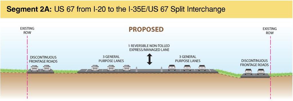
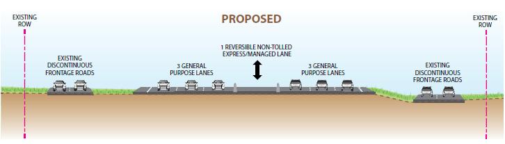
10 Proposed Project Segment 2A: US 67 from IH 35E/ US 67 interchange to IH miles Reconstruction of the existing 2 concurrent HOV lanes to 1 reversible non-tolled managed express lane Widening of the existing pavement to accommodate an additional general purpose lane in each direction for a total of 6 general purpose lanes 9

11 Proposed Project 10
12 TxDOT Public Meetings Spring 2014 May 27, 2014 Summer 2015 June 23 and 25, 2015 July 7 and 9, 2015 Winter 2015/2016 January 26 and 28, 2016 Summer 2016 Anticipate Public Hearing July/August

13 Southern Gateway Project and Public Green Funding Commitment *Regional Transportation Council presentation slide, February 11,
14 Southern Gateway Public Green Location Options and Analysis 13

15 Option A Marsalis to Ewing, 5.5 acres 14
16 Option A Marsalis to Ewing, 5.5 acres PROS Creates a deck that is accessible on all sides and provides connectivity to neighborhoods and destinations; CONS Recommends relocating Zoo entrance from frontage road to Ewing Boulevard; Provides enhanced pedestrian linkages to the Dallas Zoo; Larger size will accommodate more amenities; Provides economic development opportunities with vacant land adjacent to location; Most expensive option; Size of deck triggers a tunnel and increases capital, operational, and maintenance costs. No freeway ramps, provides opportunity to create parallel parking along the frontage roads to calm traffic; Creates opportunities for pedestrian, vehicular and bicycle connectivity to existing development on Jefferson Boulevard, nearby schools and DART Transit Station. 15

17 Option B Beckley to 12 th, 3.1 acres 16
18 Option B Beckley to 12th, 3.1 acres PROS Creates opportunities for pedestrian, vehicular and bicycle connectivity to existing development on Jefferson Boulevard and Bank of America; Provides economic development opportunities with vacant land adjacent; CONS Limits pedestrian access on two sides; More than one mile from DART Transit Station; Access ramps create conflicts for pedestrians. Size of deck does not trigger a tunnel, reduces capital, operational and maintenance costs; Less expensive than Option A. 17

19 Option C Ewing to Upton, 2.2 acres 18
20 Option C Ewing to Upton, 2.2 acres PROS Provides enhanced pedestrian linkages to the Dallas Zoo; Provides economic development opportunities with vacant land adjacent to location; CONS Limits pedestrian access to one side; Access ramps create conflicts for pedestrians. Size of deck does not trigger a tunnel, reduces capital, operational and maintenance costs; Creates opportunities for pedestrian, vehicular and bicycle connectivity to existing development on Jefferson Boulevard, nearby schools and DART Transit Station. 19

21 Option D Overton, 1.7 acres 20
22 Option D Overton, 1.7 acres PROS Provides enhanced pedestrian linkages to the DISD Educational Complex; Provides economic development opportunities with vacant land adjacent; Least expensive option; CONS Outside of the project scope; Limits pedestrian access to one side; Utility right-of-way adjacent to the location. Size of deck does not trigger a tunnel, reduces capital, operational and maintenance costs. 21
23 CONSIDERATIONS OPTION A MARSALIS to EWING OPTION B BECKLEY to 12TH OPTION C EWING to UPTON OPTION D OVERTON Access on Multi-Sides Marsalis; Ewing; NB Service Road; and SB Service Road 12 th Street; and Beckley Ewing Overton Size of Deck 5.5 acres 3.1 acres 2.2 acres 1.7 acres Adjacency to existing attraction Dallas Zoo Bank of America Tower Dallas Zoo Education Complex Availability of Parking Adjacent to Deck (within 2 blocks) Yes No Yes No Existing Density - Population within 1/4 mile, (local resident activity - walking dogs, etc.) (2010 Census Block population) Proposed Density/Catalyst Opportunity - Vacant land and developable lots within 1/4 mile 1,839 1,601 1,807 3,992 Yes Yes Yes Yes Proximity to Public Transit/DART Station 0.3 miles miles 0 22
24 COSTS OPTION A MARSALIS to EWING OPITON B BECKLEY to 12TH OPTION C EWING to UPTON OPTION D OVERTON Cost for Foundation and Deck Only $95,745, $55,268, $57,613, $27,952, Cost for Amenities and Programming ($75/square foot) $17,968, $10,127, $7,187, $5,553, Tunnel Maintenance (Annual) $1,200, $0.00 $0.00 $0.00 Cost for Operations & Maintenance (Annual estimate) $3,300, $1,860, $1,320, $1,020, TOTAL COST $118,213, $67,256, $66,120, $34,526, SOURCE OF FUNDING RTC Contribution $ 40,000, $ 40,000, $ 40,000, $ 40,000, City/Private Cost Balance $78,213, $27,256, $26,120, (-$5,473,300.00) 23

25 United States Department of Transportation Every Place Counts Design Challenge Technical Assistance Grant intended to address the impact of transportation infrastructure on communities Program purpose is to reconnect communities to job opportunities, healthcare, education, and other critical services by correcting existing infrastructure problems Recipients would receive a two-day design technical assistance workshop on transportation and conceptual design Workshop would be held in Dallas over 2 days between July 6 20, 2016 Application Deadline: June 3,
26 Resolution Key Considerations No Higher, No Wider Reduced right-of-way impacts; Increase Capacity Addition of travel lane in each direction and non-tolled Express Managed Lanes Provide access to Southwest Center Mall Direct connector ramps from US 67 to Camp Wisdom Road Multi-modal bridge crossings consistent with the City s Complete Streets Manual Enhanced landscaping and accommodations for a Southern Gateway Public Green 25
27 Next Steps - Timeline May 13, TxDOT released Request For Qualifications; plan to short list by July 28, 2016; June - Resolution from City of Dallas identifying preferred location for Southern Gateway Public Green and funding commitment; July/August - TxDOT Public Hearing (to move project into Environmental Clearance); TxDOT plan to release draft Request For Proposals - August 2016 TxDOT plan to release final Request For Proposals - October 2016 Construction Start - Fall 2017 Construction Ends
28 Appendix Draft Council Resolution 27
29 June 22, 2016 WHEREAS, Dallas traffic has consistently been ranked among the most congested in the nation; and WHEREAS, the Texas Department of Transportation (TxDOT) has received Congestion Relief Funding and has been directed to accelerate projects in the state that will address gridlock on the most congested interstates; and WHEREAS, the Southern Gateway Project is a proposed freeway improvement project that will provide congestion relief and widen IH-35E from the Horseshoe Project terminus (at Colorado) to U.S. 67 to ten main lanes and two reversible non-tolled managed express lanes, and to widen U.S. 67 from the IH-35E split to IH-20 to six main lanes and one reversible non-tolled managed express lane; and WHEREAS, the Regional Transportation Council (RTC) included the Southern Gateway Project in the region s Metropolitan Transportation Plan, called the Mobility 2040 Plan, and has consistently identified the Southern Gateway Project as the highest priority project in the eastern side of the Dallas-Fort Worth region; and WHEREAS, On March 10, 2016, the RTC approved a $656 million package of state and regional funding to construct the Southern Gateway Project; and WHEREAS, IH 35E was designed and built in the late 1950 s and early 1960 s with a horizontal curvature at Zang Boulevard that does not meet current design standards; and WHEREAS, the existing highway ramp configurations do not provide direct access to the Southwest Center Mall area; and WHEREAS, the Southern Gateway Project runs through and provides access to vital parts of the Southern Dallas community and offers an opportunity to include design elements that improve mobility and safety, enhance quality of life for the surrounding community, and encourage economic development; and WHEREAS, the Green Ribbon Fund is a TxDOT program intended to provide a higher level of visual appeal to freeway projects through landscaping and other aesthetic enhancements. Now, Therefore, BE IT RESOLVED BY THE CITY COUNCIL OF THE CITY OF DALLAS: SECTION 1. That the City Council supports the Southern Gateway Project subject to the following conditions: (a) Improved access will be provided to the Southwest Center Mall via a new northbound US 67 exit ramp to Camp Wisdom Road (b) The IH-35E mainlane alignment from Colorado Boulevard to the US 67 split will be designed and constructed to meet a 60 mile per hour design speed
30 (c) A deck will be constructed between to, to support a future public open space (Southern Gateway Public Green) that connects the communities on both sides of the freeway (d) Noise walls will be built preferably during the first phase where required as a result of the finalized noise analysis and per FHWA guidelines to protect residential areas (e) New frontage roads will be included in the project to provide access to adjacent properties (f) Bridges crossing the freeway will be enhanced to accommodate multi-modal connectivity and designed to be consistent with the City s Complete Streets Design Manual (g) Opportunities to apply for Green Ribbon Funding for enhancements along the corridor can be pursued by the City of Dallas; TxDOT will give consideration to use of Green Ribbon Funds to address areas for landscaping enhancements along the corridor (h) Sound reducing pavement will be used on the main lanes and non-tolled managed express lanes (i) TXDOT will minimize the acquisition of property associated with this project (j) TXDOT will encourage participation of DBEs, historically underutilized businesses, women owned business enterprises and minority business enterprises in all facets of the business activities of TxDOT consistent with applicable laws and regulations. SECTION 2. The City Council supports the construction of the Southern Gateway Public Green over the freeway lanes with the RTC $40 million toward the construction and the City of Dallas commits to fund the remaining cost of construction, amenities and programming, and the ongoing operation and maintenance of the Southern Gateway Public Green through public/private partnerships. SECTION 3. That this resolution shall take effect immediately from and after its passage in accordance with the provisions of the Charter of the City of Dallas and it is accordingly so resolved.
Memorandum CITY OF DALLAS
 Memorandum DATE September 23, 2016 CITY OF DALLAS TO The Honorable Members of the Transportation and Trinity River Project Committee: Lee M. Kleinman (Chair), Deputy Mayor Pro Tem Erik Wilson (Vice-Chair),
SH 199 Corridor Master Plan. Community Meeting No. 2 May 31, 2017
 Community Meeting No. 2 May 31, 2017 Transportation Projects On or Near SH 199 SH 199 from 0.3 miles south of FM 1886 to south end of Lake Worth bridge Construct freeway mainlanes and frontage roads 10-Year
Honorable Members of the Mobility Solutions, Infrastructure and Sustainability Committee
 Memorandum DATE January 23, 2019 CITY OF DALLAS TO Honorable Members of the Mobility Solutions, Infrastructure and Sustainability Committee SUBJECT I-30 East Project Update On Monday, January 28, 2019,
State Highway 121 Southwest Parkway. Fort Worth s Transportation Success Story in Design and Cooperation
 State Highway 121 Southwest Parkway Fort Worth s Transportation Success Story in Design and Cooperation Greater Fort Worth Association of Realtors October 24, 2007 Presented by: Dan Lamers, P.E. North
Memorandum CITY OF DALLAS. Riverfront Boulevard Design From Continental Avenue to Cadiz Street
 Memorandum DATE November 10, 2011 CITY OF DALLAS TO Trinity River Corridor Project Committee Members: Vonciel Jones Hill (Chair) Linda Koop (Vice Chair), Monica Alonzo, Scott Griggs, Angela Hunt, and Delia
ARLINGTON COUNTY, VIRGINIA. County Board Agenda Item Meeting of January 28, 2017 SUPPLEMENTAL REPORT-2
 ARLINGTON COUNTY, VIRGINIA County Board Agenda Item Meeting of January 28, 2017 SUPPLEMENTAL REPORT-2 DATE: January 27, 2017 SUBJECT: The Virginia Department of Transportation s Transform I-66 Inside the
ARLINGTON COUNTY, VIRGINIA. County Board Agenda Item Meeting of January 28, 2017 SUPPLEMENTAL REPORT
 ARLINGTON COUNTY, VIRGINIA County Board Agenda Item Meeting of January 28, 2017 SUPPLEMENTAL REPORT DATE: January 26, 2017 SUBJECT: The Virginia Department of Transportation s Transform I-66 Inside the
I-84 HARTFORD PROJECT HARTFORD, CONNECTICUT DRAFT PURPOSE AND NEED STATEMENT
 I-84 HARTFORD PROJECT HARTFORD, CONNECTICUT DRAFT PURPOSE AND NEED STATEMENT October 2016 I. PROJECT BACKGROUND AND HISTORY The City of Hartford is the capital of Connecticut, and the largest employment
Places29: List of Implementation Projects
 Important Points to Keep in Mind When Using This List Places29: List of s Each of the projects in this List represents an action needed to implement the Places29 Master Plan. The projects are grouped first
I-84 Hartford Project Open Planning Studio #12. April 25, 2017
 I-84 Hartford Project Open Planning Studio #12 April 25, 2017 Meeting Agenda 1. I-84 Hartford Project alternatives update 2. Multimodal station area planning 3. I-84 / I-91 Interchange Study coordination
Railyard Alternatives and I-280 Boulevard Feasibility Study. MTA Board Meeting May 6, 2014
 Railyard Alternatives and I-280 Boulevard Feasibility Study MTA Board Meeting May 6, 2014 Planned Infrastructure Major pieces of new infrastructure are planned including: Downtown Rail Extension (DTX)
4.1 Build Alternative 1 Construction Phasing
 SECTION 4 Implementation Plan This section discusses potential segmentation of the build alternatives into multiple projects for implementation of improvements to the NSH from Rabbit Creek Road to 36th
The Trinity River Corridor Project Update
 The Trinity River Corridor Project Update Councilmember Carolyn A. Davis Community Meeting October 14, 2008 The project covers 20 miles of the Trinity River, approx. 10,000 acres 2 Trinity River Corridor
The Ambassador Bridge/ Gateway Project
 The Ambassador Bridge/ Gateway Project Connecting Neighbors & Driving the Economy 2008 Ohio Conference on Freight Given by the Toledo Metropolitan Area Council of Governments, National Association of Regional
Public input has been an important part of the plan development process.
 Lakewood s Comprehensive Plan recognizes that transportation helps shape the community, and that the way the community provides for the safe and efficient movement of people affects the character of the
Mississippi Skyway Preliminary Engineering Report
 EXECUTIVE SUMMARY Mississippi Skyway Preliminary Engineering Report CITY OF RAMSEY, MINNESOTA DECEMBER 2014 City of RAMSEY EXECUTIVE SUMMARY Project Need and Intent The Mississippi Skyway pedestrian bridge
North Carolina Department of Transportation Project Development and Environmental Analysis Branch
 North Carolina Department of Transportation Project Development and Environmental Analysis Branch Citizens Informational Workshop I-85, from I-485 to NC 73 Mecklenburg and Cabarrus Counties October 30,
ALTERNATIVES. NCDOT made an early decision to first determine how to build the project (construction method) followed by what to build (alternatives).
 followed by what to build (alternatives).") III. ALTERNATIVES A. CONSTRUCTION METHOD ALTERNATIVES NCDOT made an early decision to first determine how to build the project (construction method) followed by what to build (alternatives). One of the
III. ALTERNATIVES A. CONSTRUCTION METHOD ALTERNATIVES NCDOT made an early decision to first determine how to build the project (construction method) followed by what to build (alternatives). One of the
Corridor Vision. 1Pursue Minnehaha-Hiawatha Community Works Project. Mission of Hennepin County Community Works Program
 1Pursue Minnehaha-Hiawatha Community Works Project Minnehaha-Hiawatha Community Works is a project within the Hennepin Community Works (HCW) program. The mission of the HCW program is to enhance how the
NORTH-SOUTH CORRIDOR STUDY EXECUTIVE SUMMARY. Executive Summary
 Executive Summary Background As congestion continues to affect mobility in the region, the Ozarks Transportation Organization (OTO) is particularly concerned with traffic movement. The North-South Corridor
Scope of Services. River Oaks Boulevard (SH 183) Corridor Master Plan
 Corridor Master Plan") Scope of Services River Oaks Boulevard (SH 183) Corridor Master Plan PROJECT AREA The project area consists of the River Oaks Boulevard (SH 183) corridor bounded by SH 199 at the northern end and the Trinity
Scope of Services River Oaks Boulevard (SH 183) Corridor Master Plan PROJECT AREA The project area consists of the River Oaks Boulevard (SH 183) corridor bounded by SH 199 at the northern end and the Trinity
Today Land & People. Northeast Nampa Gateway District. Employment. Land Use Characteristics. Demographics. Current Zoning
 Today Land & People Employment Major employers include Saint Alphonsus, the College of Western Idaho, the Auto Mall, Sorrento Lactalis and Walmart. 3,004 jobs in 2010 (COMPASS-CIM 2040 TAZ data) 4,345
Issues Requiring Future Study
 Issues Requiring Future Study Transportation planning is an ongoing process that tends to identify new issues as it finds solutions for others. Some issues are so complex that a solution to one problem
BUDGETING FOR OUTCOMES TRINITY RIVER CORRIDOR
 BUDGETING FOR OUTCOMES TRINITY RIVER CORRIDOR Trinity River Corridor Team Members: Kelly High, Streets Department Megan Lam, Office of Financial Services Mike Mikeska, Dallas Water Utilities Diana Ochoa,
DRAFT. Draft Addendum 1 to Visual Impact Assessment Technical Report
 Draft Addendum 1 to Visual Impact Assessment Technical Report North Houston Highway Improvement Project From US 59/I-69 at Spur 527 to I-45 at Beltway 8 North Harris County, Texas CSJ 0912-00-146 July
SBCAG STAFF REPORT. MEETING DATE: March 17, 2016 AGENDA ITEM: 5I
 SBCAG STAFF REPORT SUBJECT: Cabrillo-UPRR Bridge Project MEETING DATE: March 17, 2016 AGENDA ITEM: 5I STAFF CONTACT: Fred Luna RECOMMENDATION: Authorize the chair to sign a Memorandum of Understanding
RESOLUTION NO. R Refining the route, profile and stations for the Downtown Redmond Link Extension
 RESOLUTION NO. R2018-32 Refining the route, profile and stations for the Downtown Redmond Link Extension MEETING: DATE: TYPE OF ACTION: STAFF CONTACT: Capital Committee Board PROPOSED ACTION 09/13/2018
ROAD CONSTRUCTION. 36 June 2014 ROADS&BRIDGES
 ROAD CONSTRUCTION 36 June 2014 ROADS&BRIDGES Young is full of life Recent expansion completes continuous, multilane arterial By Donald Hammack, P.E. Contributing Author The Florida Department of Transportation
Executive Summary. NY 7 / NY 2 Corridor
 Executive Summary NY 7 / NY 2 Corridor Transportation and Land Use Study December 2005 Prepared for: Town of Colonie Capital District Transportation Committee Prepared by: Introduction: Land use decisions
16E. 24 th Street Corridor. A. Background
 A. Background The 24 th Street corridor plan includes both 24 th Street and 2550 South from 1900 West to Washington Boulevard, as shown in Map 1. 1. Development History The 24 th Street Corridor has been
I-66 EASTBOUND WIDENING INSIDE THE BELTWAY PARDON OUR DUST MEETING
 I-66 EASTBOUND WIDENING INSIDE THE BELTWAY From the Dulles Connector Road (Route 267) to Fairfax Drive (Route 237) PARDON OUR DUST MEETING Bill Cuttler, PE (VDOT District Construction Engineer, Northern
Live Oak Ramp Removal
 Live Oak Ramp Removal Mobility Solutions, Infrastructure & Sustainability September 11, 2017 Tanya Brooks, Assistant Director Mobility and Street Services Presentation Overview Purpose Background Urban
HIGHWAY INFLUENCES ON REGIONAL DEVELOPMENT. Tony Hartzel, TxDOT Northeast Texas Public Information Mgr.
 HIGHWAY INFLUENCES ON REGIONAL DEVELOPMENT Tony Hartzel, TxDOT Northeast Texas Public Information Mgr. Feb. 2, 2018 Highways and Redevelopment Central Expressway LBJ Freeway 2 What is Dallas CityMAP? Process
City of Farmington. Downtown Plan. Amendment to the 1998 Master Plan Adopted October 11, 2004
 City of Farmington Amendment to the 1998 Master Plan Adopted October 11, 2004 Introduction Planning Background 1 Scope and Components of the Plan Amendment 2 Concept Introduction 3 Plan Concepts 3 Conceptual
SR-2 Freeway Terminus Improvement Project
 SR-2 Freeway Terminus Improvement Project Welcome! Public Hearing, Mayberry Elementary June 16, 2009, 6:30 p.m. 8:30 p.m. Agenda 6:30 PM 6:50 PM Registration and Open House 6:50 PM 7:00 PM Welcome and
I-70 Corridor Enhancement Plan
 i - Table of Contents Table of Contents Chapter I Overview Chapter II Bridge and Roadway Improvements Chapter III Landscape Enhancements Chapter IV Riparian Corridors Chapter V Showcase Missouri Plan Chapter
TIRZ 17/Redevelopment Authority Capital Improvements Plan Projects
 Gessner Widening: T-1701 What: Widen the road from a six-lane divided boulevard to an eight-lane divided boulevard street section, increase turn lanes, update traffic signal system, improve drainage by
July 12, Columbus City Council City Hall 90 West Broad Street Columbus, OH RE: I-70/71 Columbus Crossroads Project
 OHIO DEPARTMENT OF TRANSPORTATION DISTRICT 6 400 EAST WILLIAM STREET DELAWARE, OHIO 43015 800.372.7714 Columbus City Council City Hall 90 West Broad Street Columbus, OH 43215-9015 RE: I-70/71 Columbus
IH35 Corridor Plan Amendment to the Comprehensive Plan
 IH35 Corridor Plan Amendment to the Comprehensive Plan Background The corridor plan for the IH35 corridor is an amendment to the Burleson comprehensive plan. Generally, the purpose of a corridor plan is
ALTERNATIVES WHAT ELSE IS POSSIBLE?
 ALTERNATIVES WHAT ELSE IS POSSIBLE? VISION STATEMENT Rather than make a ±$250 million investment that will lock in place and exacerbate the current dysfunctional system for at least 5 more decades Let
Dallas CBD Second Light Rail Alignment (D2)
") Dallas CBD Second Light Rail Alignment (D2) Subway Project Refinement City of Dallas Transportation and Trinity River Project Committee February 13, 2017 Discussion Items Background Schedule Public/Stakeholder
Dallas CBD Second Light Rail Alignment (D2) Subway Project Refinement City of Dallas Transportation and Trinity River Project Committee February 13, 2017 Discussion Items Background Schedule Public/Stakeholder
MULTI-FAMILY LAND FOR SALE
 An opportunity to acquire Multi- Family land with 1600 sft of Freeway frontage for a medium density apartment project up to 468 units. Several key economic factors make this a strategic asset that will
Route 7/15 Norwalk. Route 7/15 Norwalk Project Project Advisory Committee Meeting #5. Wednesday, November 14 th, Norwalk City Hall
 Route 7/15 Norwalk Project Project Advisory Committee Meeting #5 Route 7/15 Norwalk PAC Meeting #5 November 14, 2018 Wednesday, November 14 th, Norwalk City Hall Route 7/15 Norwalk - AGENDA Introductions
Transportation. Strategies for Action
 Transportation A major priority for the Overlake Neighborhood is to develop a multimodal transportation system. To achieve this system, a balance has to be found among travel, circulation and access needs;
The transportation system in a community is an
 7 TRANSPORTATION The transportation system in a community is an important factor contributing to the quality of life of the residents. Without a sound transportation system to bring both goods and patrons
1.0 Circulation Element
 5/9/18 1.0 Circulation Element 1.1 Introduction As growth and development occur in Apache County, enhancements to its circulation system will be necessary. With time, more roads will be paved and air and
Rezoning Transportation Analysis Petition Number: General Location Identifier:
 From: Kelsie Anderson, PE Kelsie.Anderson@charlottenc.gov 704-432-5492 Staff Reviewer: Kory Hedrick, PE, PMP Khedrick@charlottenc.gov 704-432-6511 CDOT s review of this rezoning petition is intended to
South Dakota 100 Corridor Preservation
 South Dakota 100 Corridor Preservation Purpose of this Public Hearing Inform Receive Input SD100 Project Progress East Side Corridor 1993 East Side Corridor EA March 20, 2003 SD100 Corridor Preservation
Tyvola & Archdale Transit Station Area Plan. May 15, 2008
 Tyvola & Archdale Transit Station Area Plan First Public Meeting May 15, 2008 Presentation Outline 1. Purpose and Process 2. Station Area Overview 3. Plan Recommendations Vision Land Use Transportation
APPENDIX D: Visual and Aesthetic Conditions for NCCU Station Refinement. Durham-Orange Light Rail Transit Project
 APPENDIX D: Visual and Aesthetic Conditions for NCCU Station Refinement Durham-Orange Light Rail Transit Project October 2016 1. Introduction The Combined FEIS/ROD summarizes the effects of the D-O LRT
ARROYO PROJECTS ADOPTED CAPITAL IMPROVEMENT PROGRAM BUDGET
 A RROYO P ROJECTS ADOPTED CAPITAL IMPROVEMENT PROGRAM BUDGET FISCAL YEARS 214-218 HAHAMONGNA Priority Description 1 Hahamongna Watershed Park - Implement Master Plan 211,6 211,6 (77565) 2 Hahamongna -
Eastside Transit Corridor Phase 2 Technical Study Update Community Outreach Meeting February 2017
 Eastside Transit Corridor Phase 2 Technical Study Update Community Outreach Meeting February 2017 Purpose of Tonight s Meeting Recap of Board motion (2014) and technical study process Provide update on
I-95 Interchange & Ellis Road PD&E Study
 I-95 Interchange & Ellis Road PD&E Study Brevard County, Florida Presentation to the Space Coast TPO October 14, 2010 The Project Provide a New Interchange with I-95 Using the Ellis Road Corridor, Extend
2.0 PURPOSE AND NEED. 2.1 Purpose. 2.2 Need Traffic Congestion in and around Downtown Derry
 2.0 PURPOSE AND NEED Taking into consideration agency and public input, the purpose and need for the Project was identified early in Project planning. As noted in Appendix A, for purposes of meeting the
Borderland Expressway Coalition Status Report Camino Real RMA Board Meeting. El Paso, TX April 11, 2018
 Borderland Expressway Coalition Status Report Camino Real RMA Board Meeting El Paso, TX April 11, 2018 Coalition Key Stakeholders Texas Department of Transportation New Mexico Department of Transportation
IH35 Corridor Plan Amendment to the Comprehensive Plan
 IH35 Corridor Plan Amendment to the Comprehensive Plan Background The corridor plan for the IH35 corridor is an amendment to the Burleson comprehensive plan. Generally, the purpose of a corridor plan is
I-4 Beyond the Ultimate. Florida Transportation Builders Association February 9, 2018
 I-4 Beyond the Ultimate Florida Transportation Builders Association February 9, 2018 FDOT: Improving Mobility & Safety in Central Florida FDOT is Designing and building a better I-4 through Central Florida
5.0 IMPLEMENTATION STRATEGIES
 5.0 IMPLEMENTATION STRATEGIES 5.1 Recommended Alternative This chapter discusses the anticipated steps needed to move each project from recommendation to construction. Since full funding for these alternatives
City of Dallas Complete Streets Program. SAME Infrastructure Forum February 2, 2018
 City of Dallas Complete Streets Program SAME Infrastructure Forum February 2, 2018 Complete Streets Design Manual Adopted by City Council January 27, 2016 JANUARY 27, 2016 2 What are Complete Streets?
Regional Mobility & the US 380 Bypass Concept. Informational Meeting February 9, 2017
 Regional Mobility & the US 380 Bypass Concept Informational Meeting February 9, 2017 Purpose and Agenda Purpose: Regional Mobility Issues, Priorities, and Pressures US 380 as a Limited Access Facility
Parking Garage Site Selection Committee Final Report October 15, 2012
 Parking Garage Site Selection Committee Final Report October 15, 2012 Executive Summary Recommend a Short-List of Sites for Further Review: 1. Explore the Possibility of a Private/ Public Partnership 2.
WELCOME TO OPEN HOUSE TWO November 28, 2018
 Langstaff Road Weston Road to Highway 7 Class Environmental Assessment Study WELCOME TO OPEN HOUSE TWO November 28, 2018 Please sign in and join our mailing list Study Overview York Region is conducting
Northwest Rail Corridor and US 36 BRT Development Oriented Transit Analysis 4.4 STATION AREA FINDINGS
 4.4 STATION AREA FINDINGS Each station is different, and each one requires a separate set of recommendations based on the vision for the site. This section outlines an initial TOD strategy and recommendations
We d like to thank you for attending this Wekiva Parkway Section 8 Preliminary Design Update hosted by the Florida Department of Transportation.
 We d like to thank you for attending this Wekiva Parkway Section 8 Preliminary Design Update hosted by the Florida Department of Transportation. We will provide you information on the overall project and
Project Overview. Get Involved. Public Information Meeting. Contact Information
 Get Involved VDOT representatives will review and evaluate information received as a result of this meeting. Please fill out the comment sheet provided in this brochure if you have any comments or questions.
Workshop 3. City of Burlington Waterfront Hotel Planning Study. September 14, The Planning Partnership
 Workshop 3 City of Burlington Waterfront Hotel Planning Study September 14, 2017 The Planning Partnership The Waterfront Hotel Planning Study 01 The Brant & Lakeshore Planning Study will establish a Strategic
PROJECT STATEMENT LOCATION/DESIGN PUBLIC HEARING. 19 th AVENUE NORTH EXTENSION PROJECT FROM SPRINGDALE DRIVE TO NORTH 2 ND STREET/U.S.
 PROJECT STATEMENT LOCATION/DESIGN PUBLIC HEARING 19 th AVENUE NORTH EXTENSION PROJECT FROM SPRINGDALE DRIVE TO NORTH 2 ND STREET/U.S. 67 HEARING LOCATION: ERICKSEN COMMUNITY CENTER 1401 11 TH AVENUE NORTH
METRO Gold Line BRT CMC Meeting
 METRO Gold Line BRT CMC Meeting April 26, 2018 Today s Topics Welcome and Introductions Project Overview CMC Roles and Responsibilities Current Project Baseline: Scope and Cost Estimate Overview Municipal
DRAFT MAP AMENDMENT FLU 04-4
 DRAFT MAP AMENDMENT FLU 04-4 SW 24 TH AVENUE ROADWAY CORRIDOR The University of Florida participates with the Metropolitan Transportation Planning Organization (MTPO) in its responsibilities for the continuing,
TRANSPORTATION ELEMENT GOALS, OBJECTIVES, AND POLICIES
 TRANSPORTATION ELEMENT GOALS, OBJECTIVES, AND POLICIES GOAL 2 The City shall provide a safe, convenient, effective, and energy efficient multimodal transportation system which is coordinated with the Future
Project Status. Construction is underway for Phase 3. Overall Project Area and Schedule. Schedule of Current Construction Phases.
 I-95 Avenue Interchange Project Status Construction is underway for Phase 3. Overall Project Area and Schedule Phase 0: Completed 2010 Section GR0: Completed in Fallin 2010 Phase 2: Completed Section GR2:
ADOPTED CAPITAL IMPROVEMENT PROGRAM BUDGET ARROYO PROJECTS
 ADOPTED CAPITAL IMPROVEMENT PROGRAM BUDGET ARROYO PROJECTS HAHAMONGNA FY 212-216 Capital Improvement Program Priority Description Total Estimated Costs Appropriated Through FY 211 Adopted FY 212 FY 213
Provide and maintain sufficient public parks, recreation facilities, and open space to meet the recreational needs of County residents and visitors.
 (ROS) Goal Provide and maintain sufficient public parks, recreation facilities, and open space to meet the recreational needs of County residents and visitors. OBJECTIVE ROS.01 The County shall acquire,
Elm Fork Land Use. Trinity River Corridor Project Committee May 13, 2013
 Elm Fork Land Use Trinity River Corridor Project Committee May 13, 2013 Purpose Discuss Trinity River planned Land Use and Appropriate Compatible Uses, particularly with respect to the Elm Fork Area 2
March 1, PWG Meeting #4
 March 1, 2013 PWG Meeting #4 1 Meeting Agenda 2 History & Overview Circle Interchange was built in the late 1950 s and early 1960 s, and the facility is in need of major repair or reconstruction. 3 History
Ballston Station Multimodal Study. Stakeholder Meeting October 5, 2010
 Ballston Station Multimodal Study Stakeholder Meeting October 5, 2010 Agenda Welcome and Introductions Update on Short Term Improvements Update on the Multimodal Study Recap of Goals and Key Issues Working
AASHTO SUBCOMMITTEE ON DESIGN. June 15, 2006 MARK ROBINSON, P.E. DISTRICT 5 INTERSTATE PROGRAM MANAGER FLORIDA DEPARTMENT OF TRANSPORTATION
 AASHTO SUBCOMMITTEE ON DESIGN June 15, 2006 MARK ROBINSON, P.E. DISTRICT 5 INTERSTATE PROGRAM MANAGER FLORIDA DEPARTMENT OF TRANSPORTATION CENTRAL FLORIDA INTERSTATE 4 FACTS Trucks and Others 12% Tourist
Introduction and Overview
 Introduction and Overview Articulate local values and priorities Guide land use and development decisions Coordinate transportation, infrastructure, and City services with expected growth and available
California Environmental Quality Act (CEQA) Environmental Review Process
 Environmental Review Process") California Environmental Quality Act (CEQA) Environmental Review Process Los Angeles Union Station Forecourt and Esplanade Improvements constitute a Project Los Angeles County Metropolitan Transportation
California Environmental Quality Act (CEQA) Environmental Review Process Los Angeles Union Station Forecourt and Esplanade Improvements constitute a Project Los Angeles County Metropolitan Transportation
HARBOR BRIDGE. Randall C. Grones, PE - SPD. US 181 Harbor Bridge October
 HARBOR BRIDGE Randall C. Grones, PE - SPD US 181 Harbor Bridge October October 13, 13, 2015 2015 Project Scope Develop, design, construct and maintain a total project length of 6.44 miles. Base scope New
Downtown River District
 City & Downtown Development Authority Partnership Infrastructure Analysis & Design Project Transportation & Utilities Fix Current Deficiencies Set the Stage for Future Infill & Redevelopment Who s Involved:
New Stanton Project Update July 3, 2012
 New Stanton Project Update July 3, 2012 The Needs BACKGROUND INFO I-70 Geometric Concerns Substandard Horizontal & Vertical Clearance at Center Ave. Bridge (The Center Avenue Bridge is Replaced in all
Executive Summary. The goals of the Plan are to:
 Executive Summary The Wiscasset Bath Road Master Plan (Plan) seeks to maximize development opportunities along Bath Road through the strategic coordination of traffic infrastructure improvements, land
FY 2018 TRANSPORTATION CAPITAL PROGRAM New Jersey Department of Transportation Projects
 Schooleys Mountain Bridge Rehabilitation Project ID Numbers: N1707 / 173470 Schooleys Mountain Road Bridge was built in 1920 and widened in 1937. The project is a replacement of the bridge structure and
CITY OF CHARLOTTESVILLE, VIRGINIA CITY COUNCIL AGENDA
 CITY OF CHARLOTTESVILLE, VIRGINIA CITY COUNCIL AGENDA Agenda Date: December 16, 2013 Action Required: Adoption of Resolution Presenter: Staff Contacts: Title: James E. Tolbert, AICP, Director of NDS James
Proposed FY 2004 TRANSPORTATION CAPITAL PROGRAM New Jersey Department of Transportation Projects
 Carteret Industrial Road 98547 This project will address the upgrade of Carteret Industrial Road. The federal Transportation Equity Act for the 21st Century (TEA-21) provided funding for this project under
Municipality of Anchorage. Community Council Survey Capital Projects Needs Ranking Survey (ALPHABETICAL) Airport Heights
 Airport Heights") ANCHORAGE PARKS & RECREATION Nichols Park Design and improve neighborhood park 2008 Challenge Grant applicant. 2008 $500K State Grant for Neighborhood Parks. Tikishla Park Lighting, paved parking, hockey
ANCHORAGE PARKS & RECREATION Nichols Park Design and improve neighborhood park 2008 Challenge Grant applicant. 2008 $500K State Grant for Neighborhood Parks. Tikishla Park Lighting, paved parking, hockey
Tyvola & Archdale Transit Station Area Plan. June 5, 2008
 Tyvola & Archdale Transit Station Area Plan Second Public Meeting June 5, 2008 Presentation Outline 1. Purpose and Process 2. Station Area Overview 3. Plan Recommendations 4. Comments Received and Proposed
S C O P E O F W O R K A P R I L
 white flint 2 sector plan S C O P E O F W O R K A P R I L 2 0 1 2 MONTGOMERY COUNTY PLANNING DEPARTMENT M-NCPPC MontgomeryPlanning.org 1 white flint 2 sector plan Scope of Work abstract This scope of work
The Emerald Bracelet Dallas, Texas. October 2005
 The October 2005 TABLE OF CONTENTS: Tab I Project Summary Master Illustrative Plan Tab II Woodall Rodgers Freeway Segment Tab III U.S. Highway 75 Segment Tab IV Interstate Highway 30 Segment Tab V Interstate
Transportation Committee
 Transportation Committee Business Item No. 2013-286SW Meeting date: October 14, 2013 For the Metropolitan Council meeting of October 16, 2013 Subject: Southwest Light Rail Transit (Green Line Extension):
Dallas CBD Second Light Rail Alignment (D2)
") Dallas CBD Second Light Rail Alignment (D2) Subway Project Refinement Public Meetings January 19, 2017 Discussion Items Background Schedule Public/Stakeholder Involvement Subway Construction Overview Potential
Dallas CBD Second Light Rail Alignment (D2) Subway Project Refinement Public Meetings January 19, 2017 Discussion Items Background Schedule Public/Stakeholder Involvement Subway Construction Overview Potential
REGIONAL TRANSPORTATION COMMISSION OF SOUTHERN NEVADA AGENDA ITEM
 REGIONAL TRANSPORTATION COMMISSION OF SOUTHERN NEVADA AGENDA ITEM Metropolitan Planning Organization [ X ] Transit [ ] Administration and Finance [ ] SUBJECT: PROJECT SELECTION PROCESS FOR TRANSPORTATION
NORTH CLAYMONT AREA MASTER PLAN COMMUNITY WORKSHOP #1 FEBRUARY 3, 2016
 NORTH CLAYMONT AREA MASTER PLAN COMMUNITY WORKSHOP #1 FEBRUARY 3, 2016 1. Introduction To the team and to the Plan Planning Partners The Claymont Community WILMAPCO New Castle County Claymont Renaissance
TRANSPORTATION PROJECTS
 TRANSPORTATION PROJECTS 40 BUFFALO S LWRP PROPOSED PROJECTS T1. Niagara Street/Great Lakes Seaway Trail Streetscape Project City of Buffalo Department of Public Works Niagara Street from Niagara Square
This page left intentionally blank.
 July 2012 This page left intentionally blank. Table of Contents Appendix A : Project Development Checklist Appendix B: At-Grade Rail Crossings Appendix C: Maintenance and Operations Examples Appendix D:
St. Louis Park Wooddale LRT Station Site development guidelines
 St. Louis Park Wooddale LRT Station Site development guidelines November 2013 OVERVIEW St. Louis Park s convenient location as a neighbor to Minneapolis means you re only minutes away from some of the
Gold Line Bus Rapid Transit Transit Oriented Development (BRTOD) Helmo Station Area Plan
 Helmo Station Area Plan") Appendix F Gold Line Bus Rapid Transit Transit Oriented Development (BRTOD) Helmo Station Area Plan Introduction and Purpose of the Plan The Gold Line Bus Rapid Transit facility is an eleven-mile dedicated
Appendix F Gold Line Bus Rapid Transit Transit Oriented Development (BRTOD) Helmo Station Area Plan Introduction and Purpose of the Plan The Gold Line Bus Rapid Transit facility is an eleven-mile dedicated
Making Transit Oriented Development Work For Boonton, NJ
 Making Transit Oriented Development Work For Boonton, NJ Bloustein School of Planning and Public Policy Studio Dan Burton Loannie Dao Webster Slater Brandon Williams Ian Watson Maria Laham Nicola Mammes
Route 1 Corridor Study
 Route 1 Corridor Study Westbrook, Connecticut A Vision for the Connecticut Shoreline Public Informational Meeting July 28, 2015 Lower Connecticut River Valley Council of Governments Fitzgerald & Halliday,