Urban Design Site Assessment
|
|
|
- Amy Melton
- 6 years ago
- Views:
Transcription

1 1150 Great North Road/8 Parr Road North, Point Chevalier Urban Design Site Assessment (8th February 2017)

2 1. Introduction and Overview 0B It is proposed to develop land at 1150/1158 Great North Road and 8 Parr Road North, Point Chevalier for a six storey mixed use development, consisting of two buildings linked by walkways, together comprising: Apartments o 3 x three/four bedroom walk-up units ( o 12 x three bedroom units o 23 x two bedrooms units o 33 x one bedroom units o 22 x studio units 448m2 of ground floor commercial space facing Great North Road and Parr Road North The site is 2,375m2 and currently contains an automotive workshop facing Great North Road and a single dwelling facing Parr Street. It is located within the Point Chevalier Town Centre as identified in the Auckland Plan and zoned within the Auckland Unitary Plan. This report: - - Provides an urban design assessment of the site and its surroundings to identify key features or characteristics of the site or neighbourhood. Provide an overview of the Opportunities that the development should respond to in order to achieve the best possible long term outcome for the land and its development. Assesses the proposed development against the identified opportunities and against relevant criteria from the district plan Preparation of this Report 7B This report and assessment has been prepared by Richard Knott. Richard is an Urban Designer, Heritage Specialist and Town Planner. Richard has worked in the areas of design, heritage and planning for 27 years and established his own independent consultancy Richard Knott Limited in Above: The location of the site within the wider Point Chevalier area Richard Knott Qualifications: - Master of Arts Urban Design (1995), University of the West of England, UK - Post Graduate Diploma Building Conservation (2002), Bournemouth University, UK - Bachelor of Planning (post graduate) (1989), University of Manchester, UK - Bachelor of Arts (Hons.) Town and Country Planning (1988), University of Manchester, UK Richard Knott Professional Memberships: - Chartered Member Royal Town Planning Institute - Member Institute of Historic Building Conservation - Member Institute of Highway Engineers All illustrations within this report (unless noted otherwise) have been based upon information from the Auckland Council GIS viewer.

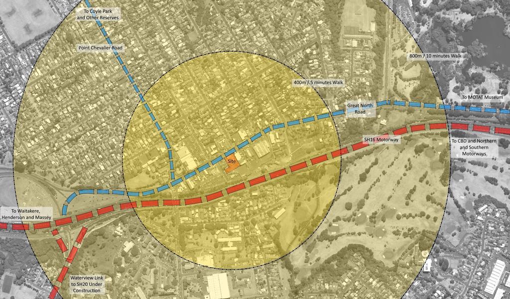
3 Neighbourhood Analysis - The site is fronts the southern side of Great North Road - There are views of the site from the SH16 North Western Motorway and also from Carrington Road to the West - It is located in the Point Chevalier Town centre as identified in the Auckland Plan and zoned within the Auckland Unitary Plan - The Auckland Plan indicates that the intention is to: DIRECTIVE 10.8 Strengthen Auckland s network of metropolitan, town, local and neighbourhood centres so they are wellconnected and meet community needs for jobs, housing, and goods and services, at a variety of scales. Auckland s network of centres will: - be the primary focus for retail and other commercial activity, providing a wide range of outlets in a competitive environment, while limiting out-of-centre retail and office development - accommodate an increase in the density and diversity of housing in and around centres - develop sufficient scale, intensity and land-use mix (appropriate to a centre s position in the hierarchy) to support high-frequency public transport - concentrate activities which generate a high number of trips - maximise access by walking, cycling and public transport and support a reduction of car trips - be attractive, mixed-use environments with high-quality public spaces. - The historic Point Chevalier Town Centre is located to the west of the site. Above: The Auckland Plan's vision for Town Centres in It is expected that land to the north and east of the town centre will be developed for terraced housing and apartment type developments, so providing demand for improved services within the town centre. - Additional residential development can be expected within the mixed housing urban areas to the north of the town centre and to the south of the SH16 north-western motorway. - Further activities supporting the expanding Point Chevalier population are provided for within a proposed mixed use area to the east of the site. - There are limited areas of open space within the town centre; consisting of the open space close to the Library and the RSA bowling club, immediately to the south of the site. - Notwithstanding the lack of quality open space within the area, the large Western Springs reserve, Walker Park, the Museum of Transport and Technology and Auckland Zoo are all within approximately 10 minutes walk of the site. - Schools and the Unitec site are all within an easy walk of the site. Overall - The land is located in the middle of the town centre. Development of the site brings the opportunity to support the Auckland Plans aspiration to accommodate an increase in density and diversity of housing in the centre and to also contribute to the range of commercial floor space available within the centre.
4 Neighbourhood Analysis 1

5 Neighbourhood Analysis 2 9B
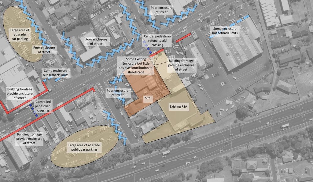
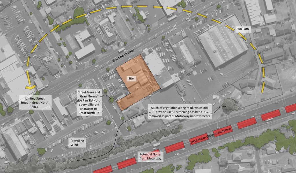
6 Site Analysis 01BThe Site - The site is within the Point Chevalier town centre and has a high-profile frontage to Great North Road. - The site also has a smaller frontage to Parr Road North. - The southern boundary of the site is with the RSA bowling club, and beyond this is the SH16 north-western motorway. - The site is relatively flat although there is a slight fall across the site from north-west to south-east. - As well as views of the site from Great North Road and Parr Road North, there are also views of the site from the SH16 North Western Motorway (located to the south) and from Carrington Road (located to the west) 1BThe Surrounding Area - Within the historic town centre of Point Chevalier, located to the west of the site, buildings front the street and provide good enclosure to the street, so creating character and interest for pedestrians and other users. - The site immediately to the west and a significant section of the northern side of Great North Road is characterised by low intensity uses, such as petrol filling stations and fast food outlets. These provide little or no enclosure to the street and do not help to create an interesting pedestrian environment along Great North Road. - Surrounding uses provide little interest to pedestrians or other passers-by. Whilst the immediately adjoining RSA is located on the street frontage and the retail premises to the east of this do the same, they each have few windows overlooking the street and provide little opportunity for interaction between users and passers-by. - As a result of the lack of enclosure provided by buildings within its immediate vicinity, the site does not feel as though it is located within a town centre as surrounding developments do not exhibit those characteristics expected within a town centre. - There are already large areas of car parking available within the town centre area which can be utilised by shoppers looking to combine visits to a number of shops in one trip. 21BLandscape and Microclimate - The provision shape and orientation of the site means that it is likely that a development could be brought forward which benefits from good solar access. - There are street trees within Great North Road, although these are currently irregularly spaced and do little to overcome the dominance of the wide road. - The street trees with berms in Parr Road North give this a different character to Great North Road. - Planting alongside the motorway, which previously softened views of the Motorway from Parr Road North and other locations has been removed as part of recent upgrade works. It appears that only limited new planting is included as part of these works. 31BOverall - The surrounding area provides a poor environment for pedestrian and other passers-by. The development of this site brings the opportunity to contribute to the improvement of this and so to the quality of the town centre in general.
7 41BLocal Environment 1
8 51BLocal Environment 2


9 Top and Bottom: Views of the site from Great North Road
")

.")
10 Right: View showing the adjoining RSA building, located to east of site (site shown to right) Right: View of Parr Road North (no.8 is recognised by red brick elevations with green steel roof) Right: Existing development to east of site (adjoining RSA). This is also zoned Town Centre


")
11 Right: Views of historic town centre buildings; located to west of site on southern side of Great North Road Right: Development along northern side of Great North Road (north and north west of site) Right: Development along northern side of Great North Road (north east of site)
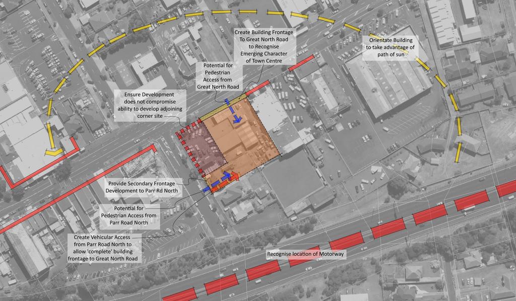
12 2. 3BSite Opportunities and Constraints 61BOverall - The land is located in the middle of the town centre. - Development of the site brings the opportunity to support the Auckland Plan s aspiration to accommodate an increase in density and diversity of housing in the centre and to also contribute to the range of commercial floorspace available within the centre. - The surrounding area provides a poor environment for pedestrian and other passers-by. The development of this site brings the opportunity to contribute to the improvement of this and so the quality of the town centre in general. 71BKey Opportunities and Constraints Opportunities and Constraints that the development should take account of include: 1. The scheme should provide an active building frontage onto Great North Road, to recognise the character of the existing development within the historic Point Chevalier town centre and in recognition of the emerging character of the new developments expected within the town centre area 2. A secondary active frontage should also be provided to Parr Street North, to provide additional interest within that street and to also provide passive surveillance over the rear of buildings fronting Great North Road/the public car park entry. 3. Vehicular access should be taken from Parr Road North to allow a complete building frontage to Great North Road 4. Pedestrian access to the development should be provided to Great North Road; to allow residents to have easy access to facilities within the centre, public transport along Great North Road and to the significant areas of recreation located within easy walking distance (including Western Springs Reserve, MOTAT and Auckland Zoo). 5. Easy pedestrian access should also be provided from Parr Road North, to ensure easy connectivity into the development from all directions 6. The buildings should be orientated to take advantage of the opportunities for good solar access offered by the site 7. The development should be located on the site and designed overall so as to not compromise the ability to develop the adjoining corner site for a multi-level mixed use development as promoted by the Auckland Plan.
13

14 Opportunities for Street Improvements The site is currently open to Great North Road, with most the frontage currently forming a vehicular crossing serving the existing forecourt area. This area to the front of the site can be reinstated as Footpath and a new kerb installed following construction of the development. A veranda/canopy along the front elevation of the new building will partly overhang this area, offering shade and shelter for pedestrians, and overall providing improved amenity to the street. There will be the opportunity for AT/AC Parks to introduce street trees in front of the building. The creation of the vehicular access to Parr Road North will require the removal of an area of berm. However, closing the existing vehicle crossing would enable an area of berm to be reinstated. (Note: Plan is intended as an illustration only. It is not to scale and the position of trees and other features have not been accurately surveyed or plotted)

. This also brings the opportunity to integrate attractive courtyard areas to the east and west.")
15 3. Proposed Development The proposed development responds to the identified opportunities and constraints and provides buildings fronting both the Great North Road and Parr Road North street frontages of the site. The larger building provides a complete frontage to Great North Road. From this a slimmer wing projects southwards into the site. This then turns eastwards to the side boundary. This arrangement enables the north-south slimmer wing to be set away from the side boundaries of the site (so protecting future occupiers from the potential dominance of buildings along these boundaries). This also brings the opportunity to integrate attractive courtyard areas to the east and west. Those to the east are private areas for adjoining units and that to the west is a public area which flows from the main apartment entrance from Great North Road, and links through to Parr Road North. The second building fronts Parr Road North, and projects eastwards into the site. The main vehicular access passes through this building. A large area of open space is provided on the roof of the larger building; accessible to all residents of both buildings. A gym and swimming pool are also provided for the benefit of all residents. The elevation to Great North Road seeks to reflect the simple shape/design and the rhythm of frontages seen within the historic Point Chevalier town centre area. This is achieved through the creation of frames around sections of the building, which break the building into two main forms, each of which is further divided vertically. I Above: Elevation to Great North Road, illustrating how the building is broken into two main elements, each of which is further subdivided so that overall the building reflects the rhythm seen within the historic Point Chevalier town centre area. Above: Further view of the north elevation, facing Point Chevalier Road, showing both buildings together. The building at 8 Parr Road North is set back approximately 40m from Great North Road. The intervening site is currently used as a car yard, but is likely to be developed for a similar mixed use development in time.


16 Right: 3D views of the proposed buildings, highlighting the plan form of each and illustrating the two courtyard areas. Please see landscape architects plans for final design for these two areas.

17 Right: Extract from Landscape Architect s plans showing detailed design for the courtyard areas.
18 4. Assessment Against Opportunities and Constraints To assess how the scheme has responded to the Opportunities and Constraints identified above, each of them is addressed below: Identified Opportunity/Constraint 1. The scheme should provide an active building frontage onto Great North Road, to recognise the character of the existing development within the historic Point Chevalier town centre and in recognition of the emerging character of the new developments expected within the town centre area Response The development provides an active building frontage to the whole of the Great North Road; the vehicular access has been located on Parr Road North to ensure that the Great North frontage is unbroken. The detailed design of the front elevation gives the building a vertical emphasis, with the elevations broken into a series of more narrow elements. This reflects the character and rhythm of the finer grained historic development to the west of the site. The majority of the Ground Floor of the building along Great North Road is set out as commercial/retail units, although an entrance lobby is provided for residents of the apartments. This gives them direct access to the building from Great North Road. 2. A secondary active frontage should also be provided to Parr Street North, to provide additional interest within that street and to also provide passive surveillance over the rear of buildings fronting Great North Road/the public car park entry. The second building provides an active frontage to Parr Road North frontage, with a shopfront facing the street for approximately half the frontage (the remainder of the frontage providing vehicular/pedestrian access to the site). The upper floors of this building span the whole site frontage, with access to these apartments being from within the site so as to not interrupt the frontage. 3. Vehicular access should be taken from Parr Road North to allow a complete building frontage to Great North Road This is achieved in the proposed development, with access from Parr Road to the underground car parking and single at grade car park. 4. Pedestrian access to the development should be provided to Great North Road; to allow residents to have easy access to facilities within the centre, public transport along Great North Road and to the significant areas of recreation located within easy walking distance (including Western Springs Reserve, MOTAT and Auckland Zoo). As noted above, there is a pedestrian entrance/lobby for the apartments accessed from Great North Road. Lift access is available to all floors from this area. The lobby links through to the courtyard, which provides direct access to some ground floor units, the gym and cycle storage area as well as linking to a further lift and stairs to all floors. 5. Easy pedestrian access should also be provided from Parr Road North, to ensure easy connectivity into the development from all directions Direct access is available to the commercial unit from Parr Road North with pedestrian access also available to the apartments through the shared space driveway which links to the courtyard. Details of the surfacing of this are shown on the landscape plans (extract above). The driveway has been carefully designed to ensure appropriate vehicle speeds to ensure the safety of pedestrians using this area. 6. The buildings should be orientated to take advantage of the opportunities for good solar access offered by the site The orientation of the building ensures that all apartments achieve good solar access in the morning, evening or during the daytime. 7. The development should be located on the site and designed overall so as to not compromise the ability to develop the adjoining corner site for a Any development on the adjoining site is likely to be placed upon the Great North Road and Parr Road North frontages, to ensure activation of the streets. The centre and rear section of the main building, and the rear of the second building have all been set away from the boundary with the corner site. As a result of this, the proposed development is unlikely to compromise the ability to deliver a development on the adjoining land.
19 multi-level mixed use development as promoted by the Auckland Plan. Identified Opportunities for Street Improvements Response The area to the front of the site, along the Great North Road frontage is shown reinstated as footpath, with the vehicular forecourt removed. A verandah is shown along the frontages of the buildings, providing shade and shelter for pedestrians and so improving the overall amenity of the streets. The creation of the vehicular access along Parr Road North, in a similar position to the existing vehicular access to the dwelling currently located on the site, means that there will be little overall change to the size of berm along Parr Road North. There will remain the opportunity for Auckland Transport to plant additional street trees along both frontages of the site. Overall the proposed development will bring positive improvements to the street environment of both Great North Road and Parr Road North.
20 5. Assessment Against Relevant Criteria from the Auckland Unitary Plan Operative in Part The relevant assessment criteria revert back to associated zone policies and includes the following: New Buildings (3) Require development to be of a quality and design that positively contributes to: (a) planning and design outcomes identified in this Plan for the relevant zone; (b) the visual quality and interest of streets and other public open spaces; and (c) pedestrian amenity, movement, safety and convenience for people of all ages and abilities. Response As part of this report an assessment has been carried out of the wider area and of the site. This has identified several opportunities and constraints. This intention is that these should influence the design of the development to ensure that it sits comfortably within the area. As identified above, the proposed development has taken account of the identified opportunities and constraints. The proposed development will provide new active frontages to both Great North Road and to Parr Road North. The building frontages have been designed to reflect the simple shape and rhythm of frontages within the historic Point Chevalier town centre. Overall it is considered that the proposed development will deliver the outcomes expected by the Auckland Plan, including: - Bringing forward additional retail/commercial floor space which ensures that the town centre can remain the primary focus for retail and other commercial activity. - Brings forward a range of apartment sizes at a density appropriate for a town centre - Will, due to the potential number of residents, support high frequency public transport - Be located and designed to encourage pedestrian and cycle trips - Is attractive and positively contributes to the amenity of the town centre Overall the development will add to the visual quality and interest of the town centre and to the general amenity and safety of the town centre. (4) Encourage universal access for all development, particularly medium to large scale development. (6) Encourage buildings at the ground floor to be adaptable to a range of uses to allow activities to change over time. (7) Require at grade parking to be located and designed in such a manner as to avoid or mitigate adverse effects on pedestrian amenity and the streetscape. (12) Recognise the functional and operational requirements of activities and development. Universal access is available to and within the development, with level access to the apartment lobby and the commercial units from Great North Road and from Parr Road North. Within the development, two lifts are provided to provide access to all floors and an appropriately designed ramp allows access from the apartment lobby to the courtyard area. The ground floor of both buildings will be in commercial use, with the exception being the apartment lobby area which faces Great North Road. Within this town centre location it is not anticipated that these areas will move out of commercial use. However, the eastern commercial area facing Great North Road is capable of subdivision into smaller spaces, each with its independent pedestrian access from the street. This area is therefore able to adapt to changing demands over time. Overall, given the high profile, town centre location of the building it is considered that it appropriately responds to this requirement. Most car parking is provided underground. There is a single at grade space adjacent to the courtyard; this is located a long distance from the street frontage with limited views of it from the shared space driveway. This requirement has been met. The consideration of functional and operational requirements has been an integral part of the design process. A balance has been struck which ensures that there is appropriate provision for parking, cycle parking, servicing etc without any of these becoming over dominant features within the development. For instance, parking has been provided under the buildings. The provision of the shared space driveway to Parr Road North allows the site to be appropriately serviced, whilst maintaining a complete built frontage to the more prominent Great North Road. Pedestrian access to the site and circulation within the site (including the location of lifts, steps, stairs and ramps) has been carefully considered to ensure that the scheme is legible to residents and visitors. In addition, the scheme will include provision of additional facilities to improve the living environment for residents including the gym, swimming pool, shared courtyard and roof top garden. These are in addition to the facilities expected within a mixed use development within a town centre.
21 (17) Manage development in town centres so that it contributes to the function and amenity of the centre. (18) Require those parts of buildings with frontages subject to the Key Retail Frontage Control to maximise street activation, building continuity along the frontage, pedestrian amenity and safety and visual quality. (19) Require those parts of buildings with frontages subject to the General Commercial Frontage Control to achieve street activation, building continuity along the frontage, pedestrian amenity and safety and visual quality. Buildings that do not comply with height and height in relation to boundary (3) Require development to be of a quality and design that positively contributes to: (a) planning and design outcomes identified in this Plan for the relevant zone; (b) the visual quality and interest of streets and other public open spaces; and (8) Require development adjacent to residential zones and the Special Purpose School Zone and Special Purpose Māori Purpose Zone to maintain the amenity values of those areas, having specific regard to dominance, overlooking and shadowing. Overall this requirement is met. The proposed development: - Provides an active ground floor frontage to both street frontages - Provides the apartment lobby on Great North Road - Introduces 93 apartments - Creates ground floor commercial floor space on street frontages - Has internalised car parking and servicing - Introduces new verandahs along street frontages - Has been designed to reflect the simple shape and rhythm of buildings within the historic Point Chevalier town centre area. Overall, the proposed development will, by virtue of the commercial floor space along the street frontages and the activity from the new residents, make a significant contribution to the function and amenity of the town centre. This applies to the Great North Road frontage. The proposed development provides a continuous frontage to Great North Road. This new active frontage is a significant improvement on the current open forecourt area to the front of the existing workshop. The development maximises the opportunity for street activation and as a result of this, the overall design of the building and provision of verandah across the whole frontage, contributes significantly to pedestrian amenity, safety and visual quality This applies to the Parr Road North frontage. The proposed development spans the complete width of this frontage, although there is not a continuous ground floor active frontage, as the shared space driveway links to Parr Road North. This new building frontage is a significant improvement on the current residential frontage, where the building is set back from the street. The development maximises the opportunity for street activation and as a result of this, the overall design of the building and provision of a verandah across the frontage, contributes significantly to pedestrian amenity, safety and visual quality As set out above the proposed development will achieve this. In addition: The proposed building: - Is entirely in line with the aspirations of the Auckland Plan that the Town Centre accommodate an increase in density and diversity of housing so that it develops sufficient scale, intensity and land-use mix to support high-frequency public transport. - The building is in general accordance with the AUP-OP with only a minor infringement of overall building height. - The proposed elevations utilise a range of materials and architectural forms and are very articulated facing the Great North Road and towards the proposed shared space at the rear. They would provide significant visual interest to the street and local area. - Overall the building shows a vertical emphasis with the elevations broken into a series of more narrow elements. This is in keeping the with the rhythm and fine grained character of the historic development to the west of the site. Notwithstanding the minor infringement of the occupiable building height, the roof form of the building will still appear of interest when viewed from the street, thanks to the overall detailed design of the elevations and roof form. N/A
22 (13) In identified locations within the centres zones, Business Mixed Use Zone, Business General Business Zone and Business Business Park Zone enable greater building height than the standard zone height, having regard to whether the greater height: (a) is an efficient use of land; (b) supports public transport, community infrastructure and contributes to centre vitality and vibrancy; (c) considering the size and depth of the area, can be accommodated without significant adverse effects on adjacent residential zones; and (d) is supported by the status of the centre in the centres hierarchy, or is adjacent to such a centre. (14) In identified locations within the centre zones, Business Mixed Use Zone, Business General Business Zone and Business Business Park Zone, reduce building height below the standard zone height, where the standard zone height would have significant adverse effects on identified special character, identified landscape features, or amenity. The site is identified as being within the area covered by the Height Variation Control - Point Chevalier, 18m. It is not identified as an area where the AUP-OP enables greater building height or a lesser building height. Whilst the majority of the larger building and all of the building which fronts Parr Road North are of a height below the anticipated 18m total building height, a small section of the building on the Great North Road frontage exceeds 18m and in the building fronting Parr Road there is a limited amount of occupiable building volume within the space allowed for roof form (i.e. greater than 16m high but less than 18m high). As indicated above, the proposed development is in keeping with the aspiration of the Auckland Plan. In relation to that part of the building which infringes the occupiable building height (but remains below the anticipated building height), the only effect of this relative to a complying building is that it allows the creation of additional usable floor space. This further allows the proposed development to meet the expectations of the Auckland Plan and to contribute to the vitality and vibrancy of the centre. As this is accommodated within what could be a complying building envelope there are no greater physical effects upon neighbours than could otherwise be anticipated. That part of the building which exceeds the overall building height represents a small percentage of the overall footprint of the building. It is located on the Great North Road frontage of the site and provides additional interest to the front and side elevation of the building. Due to its position, it is unlikely to have any impact upon the capacity or future residents of the adjoining site to the west if this is developed at a future date. The additional occupable floor space created in this area will further allow the proposed development to contribute to the vitality and vibrancy of the town centre. (15) Provide for town centres including new town centres of different scales and locations, that: (a) service the surrounding community s needs for a range of uses, such as commercial, leisure, tourist, cultural, community and civic activities; and (b) support a range of transport modes including, public transport, pedestrian and cycle networks and the ability to change transport modes. N/A
23 6. 6BConclusions Having visited the site and carried out an assessment of the neighbourhood and site itself, I consider that the development: - Fully recognises the opportunity offered by its location in the middle of the Point Chevalier town centre - Will bring forward a range of housing and retail floorspace in line with the aspirations of the Auckland Plan - Improves the local environment and quality of the town centre in general by providing high quality frontages onto Great North Road and Parr Road North - Provides direct pedestrian access from the apartments to Great North Road - Provides good passive surveillance of the adjoining streets and of internal semi-private areas - Is entirely appropriate in terms of height and scale - Does not compromise the ability to develop adjoining sites to a similar density and with a mix of uses Overall I consider that the proposed scheme has responded positively to the requirements of the Operative District Plan. In view of the above I support the proposal. Richard Knott MRTPI IHBC IHE Director, Richard Knott Limited 8 th February 2017 Richard Knott Limited PO Box Papakura, richard@richardknottltd.co.nz
I615. Westgate Precinct
 I615. Westgate Precinct I615.1. Precinct Description The Westgate Precinct is located approximately 18km west of the Auckland city centre. There are seven Sub-precincts in the Westgate Precinct: Sub-precinct
SCHEDULE 12 TO THE DESIGN AND DEVELOPMENT OVERLAY GLEN WAVERLEY ACTIVITY CENTRE STRUCTURE PLAN
 DD/MM/YY Proposed C120 SCHEDULE 12 TO THE DESIGN AND DEVELOPMENT OVERLAY Shown on the planning scheme map as DDO12. GLEN WAVERLEY ACTIVITY CENTRE STRUCTURE PLAN 1.0 Design objectives DD/MM/YY Proposed
Section Three, Appendix 16C Medium Density Housing, Design Assessment Criteria (Residential 8A zone)
") APPENDIX 16C MEDIUM DENSITY HOUSING, DESIGN ASSESSMENT CRITERIA (RESIDENTIAL 8A ZONE) PURPOSE OF APPENDIX 16C (RESIDENTIAL 8A ZONE) In the Residential 8A Zone the following are defined as restricted discretionary
APPENDIX 16C MEDIUM DENSITY HOUSING, DESIGN ASSESSMENT CRITERIA (RESIDENTIAL 8A ZONE) PURPOSE OF APPENDIX 16C (RESIDENTIAL 8A ZONE) In the Residential 8A Zone the following are defined as restricted discretionary
H10. Business Town Centre Zone
 H10. Business Town Centre Zone H10.1. Zone description The Business Town Centre Zone applies to suburban centres throughout Auckland, the satellite centres of Warkworth and Pukekohe, and the rural towns
H9. Business Metropolitan Centre Zone
 H9. Business Metropolitan Centre Zone H9.1. Zone description The Business Metropolitan Centre Zone applies to centres located in different subregional catchments of Auckland. These centres are second only
WELLINGTON HOSPITAL DESIGN GUIDE TABLE OF CONTENTS
 WELLINGTON HOSPITAL DESIGN GUIDE TABLE OF CONTENTS 1.0 Introduction Page 2 The Place of Wellington Hospital 2 The Future of the Hospital 2 2.0 The Intention of the Design Guide 3 3.0 Analysis 4 General
Section Three, Appendix 17C Multiple Unit Housing Design Assessment Criteria
 APPENDIX 17C MULTIPLE UNIT HOUSING DESIGN ASSESSMENT CRITERIA Purpose of Appendix 17C In the Residential 9 Zone the construction and use of multiple household units located within the Multiple Household
I539. Smales 2 Precinct
 I539. Smales 2 Precinct I539.1. Precinct Description The Smales 2 Precinct applies to a 4.8 hectare block of land located on the southern side of Northcote Road and fronting Lake Pupuke, Takapuna. The
H13. Business Mixed Use Zone
 H13. Business Mixed Use Zone H13.1. Zone description The Business Mixed Use Zone is typically located around centres and along corridors served by public transport. It acts as a transition area, in terms
H14. Business General Business Zone
 H14. Business General Business Zone H14.1. Zone description The Business General Business Zone provides for business activities from light industrial to limited office, large format retail and trade suppliers.
medium desnity housing
 This section updated September 2013 This part of the Plan sets out the assessment criteria for medium density housing. The criteria are designed to give designers and builders flexibility and to provide
The Proposed Auckland Unitary Plan (notified 30 September 2013)
") 3 Business zones Introduction There are 10 business zones in the Unitary Plan: City Centre Metropolitan Centre Town Centre Local Centre Neighbourhood Centre Mixed Use General Business Business Park Light
3 Business zones Introduction There are 10 business zones in the Unitary Plan: City Centre Metropolitan Centre Town Centre Local Centre Neighbourhood Centre Mixed Use General Business Business Park Light
I331. St John s Theological College Precinct
 I331. St John s Theological College Precinct I331.1. Precinct Description The precinct contains the existing St John s Theological College which is a residential college for the Anglican Church in New
Front Yard Landscaping
 Version 1 Apr 2018 R1 Residential Design Element Front Yard Landscaping Overview Front yard landscaping plays an important role in creating the attractive, green streetscapes that typify many of Auckland
6 Site Framework Strategies
 6 Site Framework Strategies 6.1 Introduction Section 6 identifies a number of specific areas which are considered to be key sites within the Plan area and which may have potential for development / redevelopment.
THREE PARKS ZONE Three Parks Special Zone The process of applying for resource consents in the zone.
 .25 Three Parks Special Zone The purpose of this zone is to provide for growth and to give effect to the Wanaka 2020 Community (2002) and the more recent Wanaka Structure (2007) and Wanaka Transport Strategy
SITE ANALYSIS CALVARY HOSPITAL NORTH ADELAIDE LARGE INSTITUTIONS AND COLLEGES DPA CALVARY HOSPITAL
 SITE ANALYSIS Located at: 81-100 Strangways Terrace 55-79 Barnard Street 2-34 Hill Street 312-320 Ward Street HISTORY The Calvary Hospital was established in 1900 and is one of Adelaide's oldest hospitals.
Subdivision Design Criteria. Penihana North GUIDELINES TO THE RULES
 Created September 2013 Penihana North Subdivision Design Criteria GUIDELINES TO THE RULES This part of the Plan sets out the design criteria for subdivision in Penihana North. The criteria will be considered
Part 9 Specific Land Uses - Housing on Small and Narrow Lots
 19 HOUSING ON SMALL AND NARROW LOTS This section of the DCP applies where development for the purpose of a dwelling house, attached dwellings, or semi-detached dwellings is or are proposed in the R2 Low
PART AOTEA PRECINCT
 CONTENTS... PAGE AOTEA PRECINCT...4 14.5.1 INTRODUCTION...4 14.5.2 RESOURCE MANAGEMENT ISSUES...4 14.5.3 RESOURCE MANAGEMENT OBJECTIVES AND POLICIES... 4 14.5.4 RESOURCE MANAGEMENT STRATEGY...5 14.5.5
Tāhuhu whakaruruhau ā-taone The sheltering ridge pole
 B2. Tāhuhu whakaruruhau ā-taone - Urban growth and form B2.1. Issues Tāhuhu whakaruruhau ā-taone The sheltering ridge pole Auckland s growing population increases demand for housing, employment, business,
Chapter 5 Urban Design and Public Realm
 5.1 Introduction Public realm is all areas of the urban fabric to which the public have access. It is where physical interaction takes place between people. It therefore, includes buildings and their design,
RESIDENTIAL ACTIVITY PERFORMANCE STANDARDS
 Preferred Options Consultation Q&A Sheet RESIDENTIAL ACTIVITY PERFORMANCE STANDARDS What are the key goals for managing the design of residential buildings in the Second Generation Plan (2GP)? The key
Chapter 2: OUTLINE PLANNING APPLICATION PROPOSALS. A New Garden Neighbourhood Matford Barton 17
 Chapter 2: OUTLINE PLANNING APPLICATION PROPOSALS A New Garden Neighbourhood Matford Barton 17 2.1. SUMMARY AND STATUS OF THE PROPOSALS 2.1.1. The parameter plans and associated wording in this chapter
The Proposed Auckland Unitary Plan (notified 30 September 2013)
") 8 Special Purpose zones 8.1 Airport zone The Airport zone applies to the Kaipara Flats Airfield, North Shore Airfield, Auckland International Airport and Ardmore Airport. Auckland International Airport
8 Special Purpose zones 8.1 Airport zone The Airport zone applies to the Kaipara Flats Airfield, North Shore Airfield, Auckland International Airport and Ardmore Airport. Auckland International Airport
I209 Quay Park Precinct
 I209. Quay Park I209.1. Precinct description The Quay Park Precinct is located on reclaimed land at the eastern end of the city centre and along the City Centre waterfront. It is dissected to the east
Design Guide: - Residential Centres
 Design Guide: - Residential Centres Introduction Hamilton City Council wishes to take a stronger and more visionary role in guiding the future development of Hamilton s built environment to ensure that
Nelson Residential Street Frontage Guideline
 DRAFT 22-06-2012 Nelson Residential Street Frontage Guideline June 2012 1317273 Contents and purpose Residential s are important Residential s are much more than corridors which move traffic. Streets allow
Buildings may be set back to create small plazas provided that these setbacks do not substantially disrupt the street wall s continuity.
 6-22 Community Design Street Walls and Street-front Setbacks The siting of buildings will play a critical role in establishing the character and sense of place for the District. Siting buildings at the
I207. Learning Precinct
 I207. Learning Precinct I207.1. Precinct description The Learning Precinct is centred on the Symonds Street ridge where the University of Auckland and Auckland University of Technology have the majority
Memorial Business Park Site. Proposed Future Development. Design guidelines. August
 Memorial Business Park Site Proposed Future Development Design guidelines August 2014 www.designenvironment.co.nz 0064 3 358 3040 Contents 1.0 Background 1.1 Introduction 3 1.2 Objectives 4 2.0 Context
Chapter 13 Residential Areas: Appendices APPENDIX 1 Residential Areas
 Chapter 13 Residential Areas: Appendices Page 1 Chapter 13 Residential Areas: Appendices APPENDIX 1 Residential Areas Design Code for Intensive Housing INTRODUCTION DESIGN ELEMENTS A NEIGHBOURHOOD DESIGN
GREENFORD HALL & ADJOINING LAND
 GREENFORD HALL & ADJOINING LAND CONTENTS 1. Introduction 1. Introduction 2. Urban Context 2.1 The Site and Surroundings 2.2 Urban Context Map 2.3 Access and Movement 3. Planning Context 3.1 Planning History
H7 Open Space zones. (a) provide for the needs of the wider community as well as the needs of the community in which they are located;
 provide for the needs of the wider community as well as the needs of the community in which they are located;") H7. Open Space zones H7.1. Background The majority of land zoned as open space is vested in the Council or is owned by the Crown. However some areas zoned open space are privately owned. While the open
H7. Open Space zones H7.1. Background The majority of land zoned as open space is vested in the Council or is owned by the Crown. However some areas zoned open space are privately owned. While the open
01 the vision NEW LYNN IS WAITING FOR THE GREAT LEAP FORWARD
 [A] FRAMEWORK 01 the vision 02 the framework 03 urban design principles 04 c o n t e x t 05 issues a n d o p p o r t u n i t i e s 06 creating a t.o.d. 07 key recommendations 08 seven strategic areas of
Urban Design Guidelines
 Urban Design Guidelines These Urban Design Guidelines comprise the Key Design Objectives below, the Roads Design Guidelines overleaf and Neighbourhood Framework Plans. Together with Section 3: Urban Design
Plan Modification to Chapter B2 of the Auckland Unitary Plan(AUP) Operative in part (15 November 2016)
 Operative in part (15 November 2016)") UNITARY PLAN UPDATE REQUEST MEMORANDUM TO FROM Phill Reid Linley Wilkinson DATE 25 September 2018 SUBJECT Plan Modification to Chapter B2 of the Auckland Unitary Plan(AUP) Operative in part (15 November
UNITARY PLAN UPDATE REQUEST MEMORANDUM TO FROM Phill Reid Linley Wilkinson DATE 25 September 2018 SUBJECT Plan Modification to Chapter B2 of the Auckland Unitary Plan(AUP) Operative in part (15 November
Policies and Code Intent Sections Related to Town Center
 Policies and Code Intent Sections Related to Town Center The Town Center Vision is scattered throughout the Comprehensive Plan, development code and the 1994 Town Center Plan. What follows are sections
H1. Residential Large Lot Zone
 H1. Residential Large Lot Zone H1.1. Zone description The Residential Large Lot Zone provides for large lot residential development on the periphery of urban areas. Large lot development is managed to
(DC1) Direct Development Control Provision DC1 Area 4
 Direct Development Control Provision DC1 Area 4") . General Purpose (DC) Direct Development Control Provision DC Area 4 The purpose of this Provision is to provide for an area of commercial office employment and residential development in support of the
. General Purpose (DC) Direct Development Control Provision DC Area 4 The purpose of this Provision is to provide for an area of commercial office employment and residential development in support of the
4 RESIDENTIAL ZONE. 4.1 Background
 4 RESIDENTIAL ZONE 4.1 Background The residential areas within the City are characterised by mainly lowrise dwellings sited on individual allotments. Past architectural styles, settlement patterns and
MVRC ARCHITECTURAL DESIGN STATEMENT
 11251 MOONEE VALLEY RACING CLUB MAY 201 CONTENTS 0 Contents Introduction 1 Site Analysis a. Site Features b. Built form Interfaces c. Existing Streetscape d. Site Opportunities and Constraints 2 Masterplan
KWE.1 Kamo Walkability Environment
 KWE.1 Kamo Walkability Environment Index KWE.1 Kamo Walkability Environment KWE.1.1 Description and Expectations KWE.1.2 Eligibility Rule KWE.1.3 Objectives KWE.1.4 District Wide Note KAP.1 Kamo Activity
Welcome. Land adjacent Sandy Lane WALTHAM CHASE THE PROPOSED SITE
 Land adjacent Sandy Lane WALTHAM CHASE Existing Linden Homes developments Welcome Welcome to Linden Homes Southern s ( Linden ) public exhibition about its proposals for a range of high-quality homes for
This image is an illustration of a similar scale scheme on a different site by Stitch
 Stitch design approach Site 74 - MALTON HOUS This image is an illustration of a similar scale scheme on a different site by Stitch Stitch has been appointed as architect for six sites across the northern
Appendix 1 Structure plan guidelines
 Appendix 1 Structure plan guidelines This appendix forms part of the regional policy statement [rps]. 1.1. Introduction Structure plans are an important method for establishing the pattern of land use
WELCOME GYPSY LANE. Wider Site Location plan. Proposals for the development of LAND OFF FOXLYDIATE LANE WEBHEATH. Proposals for the development of
 WELCOME The developers are preparing an outline planning application for a residential led development and need the community s views in order to develop the proposals further WHAT IS PROPOSED? A high
MASTER PLAN NO. 60 (SITE DEVELOPMENT PLAN EASTBANK/REGATTA NORTH PRECINCTS 2 4) 2008
 2008") Page 2 TABLE OF CONTENTS PAGE 1 PRELIMINARY... 5 1.1 CITATION... 5 1.2 TYPE OF MASTER PLAN... 5 1.3 LEGAL REQUIREMENT FOR MASTER PLAN... 5 1.4 LEGAL EFFECT OF THE MASTER PLAN... 5 2 DESCRIPTION OF LAND...
Page 2 TABLE OF CONTENTS PAGE 1 PRELIMINARY... 5 1.1 CITATION... 5 1.2 TYPE OF MASTER PLAN... 5 1.3 LEGAL REQUIREMENT FOR MASTER PLAN... 5 1.4 LEGAL EFFECT OF THE MASTER PLAN... 5 2 DESCRIPTION OF LAND...
I609. Penihana North Precinct
 I609. Penihana North Precinct I609.1. Precinct description The Penihana North Precinct is located south of the Swanson Railway Station, adjacent to the Rural Urban Boundary (RUB) and Waitakere Ranges Heritage
Building and Public Space Design Guidelines
 AMERICA'S CUP WYNYARD HOBSON Building and Public Space Design Guidelines INTRODUCTION 10 April 2018 The 36 th America s Cup in Auckland requires the construction of new wharf and breakwater structures.
UNITARY PLAN. Your Easy Guide to understanding the Residential Standards. Version 35. waste. outlook. landscapes. context. parking
 UNITARY PLAN Your Easy Guide to understanding the Residential Standards waste outlook landscapes height context fencing parking street interface daylight Version 35 June March 2017 2018 The Easy Guide
STATEMENT OF OBJECTION TO THE PROPOSED DEVELOPMENT OF LAND AT CHURCH CLIFF DRIVE FILEY
 STATEMENT OF OBJECTION TO THE PROPOSED DEVELOPMENT OF LAND AT CHURCH CLIFF DRIVE FILEY You will be aware that Scarborough borough council have adopted a new local plan that includes land at Church Cliff
8.0 Design and Form of Development 43/
 42/ 8.0 Design and Form of Development 43/ Rothwells Farm, Golborne/ Development Statement Figure 7. Site Constraints Key 44/ Site Boundary 360 Bus Route/Stops Existing Trees Underground Water Pipe Sensitive
Next Steps / Development Process. Structure Plan. June submitted to City of Fremantle. Structure Plan. July supported for advertising
 overview What is today about? In July 0, the City of Fremantle resolved that the be advertised for public comment. Today is about: Understanding the history and context of the site Having your say on the
I403 Beachlands 1 Precinct
 I403. Beachlands 1 I403.1. Precinct Description Beachlands is a rural and coastal village located on the eastern side of Auckland, adjoining the Tamaki Strait coastline. The original Beachlands village
APPENDIX 1 DISTRICT PLAN CHANGE REQUEST
 APPENDIX 1 DISTRICT PLAN CHANGE REQUEST Summerset Villages (Lower Hutt) Ltd District Plan Change Request Prepared by Urban Perspectives Ltd 17 September 2014 65 39 66 PROPOSED DISTRICT PLAN CHANGE PROVISIONS
Northern Territory Compact Urban Growth Policy
 Northern Territory Compact Urban Growth Policy A Reference Policy Document to clause 2.7 (Reference to Policy) of the NT Planning Scheme May 2015 Table of Contents 1 Policy Setting... 3 1.1 Context for
AOTEA SUPERMARKET ZONE. Zone Introduction
 C18 AOTEA SUPERMARKET ZONE Zone Introduction C18.1 Objective This zone identifies a specific area in Aotea for a stand alone supermarket. The zone is site specific and has a range of objectives, policies
Keystone Business Park Precinct Structure Plan North East Industrial Precinct. Part 2 Design Principles
 Keystone Business Park Precinct Structure Plan North East Industrial Precinct Part 2 Design Principles Context Issues Services Landform Issues Geotech and contamination Ecology Traffic and access Issues
King s College Proposed Private Plan Change 41 Golf Avenue, Otahuhu URBAN DESIGN ASSESSMENT
 King s College Proposed Private Plan Change 41 Golf Avenue, Otahuhu URBAN DESIGN ASSESSMENT CONTENTS 1.0 EXCECUTIVE SUMMARY... 1 2.0 INTRODUCTION... 2 2.1 Purpose of document... 2 2.2 Report structure...
A VISION FOR BLAIRGOWRIE
 Welcome to the Westpark Partnership and Lidl UK GmbH Community Presentation. The purpose of this presentation is for you to view and comment upon the revised and updated proposals for the allocated development
Urban Design Brief to 1557 Gordon Street & 34 Lowes Road West
 Urban Design Brief 1533 to 1557 Gordon Street & 34 Lowes Road West Reid s Heritage Homes Ltd. & 883928 Ontario Ltd. and RHH Property Management Ltd. City of Guelph Zoning By-law Amendment November 2017
THREE KINGS RENEWAL DESCRIPTION OF URBAN DESIGN / ARCHITECTURAL ELEMENTS AND PROCESS. prepared by dko Architecture
 THREE KINGS RENEWAL DESCRIPTION OF URBAN DESIGN / ARCHITECTURAL ELEMENTS AND PROCESS prepared by dko Architecture THESE PLANS OUTLINE THE VISION OF FLETCHER RESIDENTIAL LTD AND ARE NOT ENDORSED BY AUCKLAND
4 Residential and Urban Living Zones
 4 Residential and Urban Living Zones Refer to Chapters 11 to 20 for additional rules that may apply to these zones. 4.1 OBJECTIVES AND POLICIES Objective Res1 Policy 1 Policy 2 Policy 3 Policy 4 Policy
4.0 Design Guidelines For The Village Centre. South fields Community Architectural Design Guidelines Town of Caledon
 4.0 Design Guidelines For The Village Centre 4.0 Design Guidelines for the Village Centre The Village Centre is the focal point of the entire South Fields Community and is designed as a traditional commercial
Land Adj. 63 Sunny Bank Road, Sutton Coldfield, Birmingham, B73 5RJ
 Committee Date: 11/07/2013 Application Number: 2013/03520/PA Accepted: 20/05/2013 Application Type: Full Planning Target Date: 15/07/2013 Ward: Sutton Vesey Land Adj. 63 Sunny Bank Road, Sutton Coldfield,
Derry City and Strabane District Council Planning Committee Report
 Derry City and Strabane District Council Planning Committee Report COMMITTEE DATE: 23 rd March 2016 APPLICATION No: APPLICATION TYPE: PROPOSAL: LOCATION: APPLICANT: LA11/2015/0395/F Residential Development
6.0 Land Use Policies for Rural Settlements. 6.1 Rural Settlement Strategy
 6.0 Land Use Policies for Rural Settlements 6.1 Rural Settlement Strategy INTRODUCTION AMENDMENT NO. 131 PURPOSE Designated rural settlements comprise Rural Clusters, Villages and Serviced Villages as
REMARKABLES PARK ZONE
 .10 Remarkables Park Zone.10.1 Resources, Activities and Values The Remarkables Park Area comprises approximately 150 hectares of perimeter urban land in the vicinity of Frankton and occupies a strategic
DRAFT DRAFT DRAFT DRAFT
 # 19 EXPAND GREEN AND OPEN SPACES AND COMMUNITY FACILITIES IN TANDEM WITH NEW DEVELOPMENT The role of Eglinton will change in the coming years, along with the intensity of activity and land uses. As more
Contents of Part 6. Part 6 Zones
 Contents of Part 6 Part 6 Zones... 6-1 6.1 Preliminary... 6-1 6.2 Zone codes... 6-3 6.2.1 Low density residential zone code... 6-3 6.2.1.1 Application... 6-3 6.2.1.2 Purpose and overall outcomes... 6-3
therry, elizabeth, franklin and queen: BLOCK plan
 therry, elizabeth, franklin and queen: BLOCK plan INTRODUCTION Therry, Elizabeth, Franklin and Queen Street block Purpose & background The City of Melbourne has prepared this document for developers and
City of Vaughan Urban Design Guidelines for Infill Development in Established Low-Rise Residential Neighbourhoods
 City of Vaughan Urban Design Guidelines for Infill Development in Established Low-Rise Residential Neighbourhoods DRAFT - September 2016 Contents 1. Introduction 1 2. Policy Context 3 3. Characteristics
BLACKHEATH SQUASH CLUB Blackheath Sports Club, Rectory Field, Charlton Road, London, SE7 7EY. Planning, Design and Access Statement
 Planning, Design and Access Statement Revised: 28 th Jan 2016 Peter Pendleton & Associates Ltd Introduction Planning permission will be sought for a refurbishment of existing courts and extension to provide
PLANNING STATEMENT. Market House Market Place Kingston upon Thames KT1 1JS
 PLANNING STATEMENT To support planning and listed building consent applications for change of use from Class A1 shop and Class A3 cafe to Class A3 restaurant at: Market House Market Place Kingston upon
Housing Development at Balloonagh Tralee Co Kerry
 Design Statement Housing Development at Balloonagh Tralee Co Kerry Area of site 10,400m2 24 houses-12no 3 bed, 12no 2 bed and 4 single bed apartments total residential area of 2411m2 Open space provided
1. Assessment of Environmental Effects
 1. Assessment of Environmental Effects Table of Contents 1. Introduction and Overview 1 2. Statutory Assessment 3 3. Site Description 5 4. Proposal Description 7 5. Assessment of Effects on the Environment
PART TWO: URBAN DESIGN GUIDELINES 09 INTRODUCTION TO URBAN DESIGN GUIDELINES
 PART TWO: URBAN DESIGN GUIDELINES 09 INTRODUCTION TO URBAN DESIGN GUIDELINES 103 NORTH COAST URBAN DESIGN GUIDELINES 09 INTRODUCTION TO URBAN DESIGN GUIDELINES 9.0 INTRODUCTION The purpose of Part Two
Site north of Hattersley Road West (east of Fields Farm Road), Hattersley
, Hattersley") Application Number 17/00982/REM Proposal Site Applicant Recommendation Reason for report Application for the approval of reserved matters (means of access, landscaping, layout, scale and appearance) relating
Application Number 17/00982/REM Proposal Site Applicant Recommendation Reason for report Application for the approval of reserved matters (means of access, landscaping, layout, scale and appearance) relating
22.15 OUTDOOR ADVERTISING SIGNAGE POLICY
 22.15 OUTDOOR ADVERTISING SIGNAGE POLICY This policy applies to all land where a planning permit is required to construct or display a sign under the provisions of the Kingston Planning Scheme. 22.15-1
KANATA CENTRUM 255 KANATA AVENUE OFFICIAL PLAN AMENDMENT ZONING BY-LAW AMENDMENT
 KANATA CENTRUM 255 KANATA AVENUE OFFICIAL PLAN AMENDMENT ZONING BY-LAW AMENDMENT JUNE 2015 PREPARED BY: FOTENN Consultants Inc. 223 Mcleod Street Ottawa, ON K2P OZ8 (613) 730-5709 PREPARED FOR: Kanata
MATURE SUBURBS RESIDENTIAL DEVELOPMENT GUIDELINES
 MATURE SUBURBS RESIDENTIAL DEVELOPMENT GUIDELINES DRAFT FEBRUARY 2005 BIRMINGHAM CITY COUNCIL 1 Introduction Mature Suburbs Residential Development Guidelines - Interim Supplementary Planning Advice -
Page 1 of 19 URBAN DESIGN FRAMEWORK FOR BOLTON STREET WATERFORD
 Page 1 of 19 URBAN DESIGN FRAMEWORK FOR BOLTON STREET WATERFORD 1.0 Introduction: The relocation of the City Council stores and depot from Bolton Street creates an exciting opportunity for development
Ensure that development within the Arrowtown Urban Growth Boundary provides:
 URBAN DEVELOPMENT 4 4.2.5.2 Ensure that development within the Arrowtown Urban Growth Boundary provides: an urban form that is sympathetic to the character of Arrowtown, including its scale, density, layout
Colchester Northern Gateway Master Plan Vision Review Draft. July 2016
 Colchester Northern Gateway Master Plan Vision Review Draft July 2016 Contents Introduction 4 Context 8 Purpose of the Report 8 Strategic Position 9 Overview of the Process 11 2012 Master Plan Vision 12
YMCA Erdington (Phase 2), 300 Reservoir Road, Erdington, Birmingham, B23 6DB
, 300 Reservoir Road, Erdington, Birmingham, B23 6DB") Committee Date: 13/06/2013 Application Number: 2013/03011/PA Accepted: 30/04/2013 Application Type: Full Planning Target Date: 30/07/2013 Ward: Stockland Green YMCA Erdington (Phase 2), 300 Reservoir Road,
Committee Date: 13/06/2013 Application Number: 2013/03011/PA Accepted: 30/04/2013 Application Type: Full Planning Target Date: 30/07/2013 Ward: Stockland Green YMCA Erdington (Phase 2), 300 Reservoir Road,
APPENDIX 10 THE RESIDENTIAL DESIGN GUIDE FOR DEVELOPMENTS IN RESIDENTIAL ZONES IN SPECIFIED GROWTH AREAS
 THE RESIDENTIAL DESIGN GUIDE FOR DEVELOPMENTS IN RESIDENTIAL ZONES IN SPECIFIED GROWTH AREAS ISTHMUS SECTION - OPERATIVE 1999 Page 1 CONTENTS... PAGE 1.0 INTRODUCTION... 4 1.1 Growth Management Strategy...
17A. Wind Microclimate
 17A. Wind Microclimate 17A.1 Introduction 17A.1.1 17A.1.2 17A.1.3 17A.1.4 This Chapter, which has been prepared by Waterman and BMT, provides further information with regard to the potential wind microclimate
10 Proposed Redevelopment, Tewkesbury Road, Cheltenham SCHEME EVOLUTION STARBUCKS
 SCHEME EVOLUTION STARBUCKS The proposed Starbucks Drive Thru alongside the proposed food store provides an appropriate mix of uses, suitable for this location. The proposed store is bespoke, designed specifically
3.1 The hybrid planning application proposes the following description of development:
 CHAPTER 3: PROPOSED DEVELOPMENT 3.1 The hybrid planning application proposes the following description of development: Hybrid (part-outline/part-full) planning application for a single composite development
2A District-wide Policies
 2A Introduction This Chapter contains policies which are relevant to subdivision, use and development activities occurring across all zones and areas of the District. The policies in this Chapter implement
INCREMENTAL CHANGE AREA REVIEW March 2015 Page 1
 INCREMENTAL CHANGE AREA REVIEW March 2015 Page 1 Table of Contents Introduction... 3 Background to Review... 3 Comparison of the Schedules to the General Residential Zone... 7 Methodology... 7 Policy Context...
4.0 URBAN DESIGN FRAMEWORK. The vision for the future development of the plan area is to:
 4.0 The vision for the future development of the plan area is to: Create a new neighbourhood that focuses on the highly valued natural and aesthetic features of the lands and provides good quality homes,
PORT WHITBY COMMUNITY
 PORT WHITBY COMMUNITY SECONDARY PLAN UPDATE COMMUNITY IMPROVEMENT PLAN URBAN DESIGN GUIDELINES September 2015 DRAFT PROPOSED AMENDMENT NUMBER # to the Whitby Official Plan PURPOSE: The intent of this Amendment
DELEGATED DECISION on 1st September 2015
 Application N o : 14/04810/OUT LONDON BOROUGH OF BROMLEY TOWN PLANNING RENEWAL AND RECREATION DEPARTMENT DELEGATED DECISION on 1st September 2015 14/04810/OUT Claire Harris 4 Oaklands Road Bromley BR1
URBAN DESIGN BRIEF URBAN DESIGN BRIEF 721 FRANKLIN BLVD, CAMBRIDGE August 2018
 URBAN DESIGN BRIEF URBAN DESIGN BRIEF 721 FRANKLIN BLVD, CAMBRIDGE August 2018 DESIGN BRIEF CONTENTS PART A 1.0 INTRODUCTION 2.0 DESCRIPTION & ANALYSIS OF SITE CONTEXT 3.0 DESIGN CONSTRAINTS AND OPPORTUNITIES
Horwood Map of London, Westminster & Southwark First edition
 Barratt London is developing plans in tandem with Southwark Council and TfL to transform the southern end of Blackfriars Road. The residential-led, mixed-use scheme will deliver new private and affordable
East Bayshore Road Neighbourhood
 East Bayshore Road Neighbourhood Northridge Property Management Urban Design Brief 3195 East Bayshore Road City of Owen Sound January 2016 East Bayshore Road Neighbourhood Northridge Property Management
PLANNING RATIONALE FOR THE PROPOSED RIVERSIDE SOUTH ELEMENTARY SCHOOL 715 BRIAN GOOD AVENUE, OTTAWA, ON
 PLANNING RATIONALE FOR THE PROPOSED RIVERSIDE SOUTH ELEMENTARY SCHOOL 715 BRIAN GOOD AVENUE, OTTAWA, ON Conseil des écoles publiques de l'est de l'ontario (CEPEO) French Public School Board TABLE OF CONTENTS
URBAN DESIGN BRIEF. 2136&2148 Trafalgar Road. Town of Oakville
 URBAN DESIGN BRIEF 2136&2148 Trafalgar Road Town of Oakville Prepared By: METROPOLITAN CONSULTING INC For 2500674 Ontario Inc November 2016 TABLE OF CONTENTS Page No. 1.0 Introduction/Description of Subject