Heritage Valley Town Centre Neighbourhood Area Structure Plan
|
|
|
- Silvia Wheeler
- 6 years ago
- Views:
Transcription
1 Heritage Valley Town Centre Neighbourhood Area Structure Plan Office Consolidation March 2011 Prepared by: Current Planning Branch Planning and Development Department City of Edmonton Bylaw was adopted by Council in December In March 2011, this document was consolidated by virtue of the incorporation of the following bylaws, which were amendments to the original Bylaw Bylaw Bylaw Approved December 16, 2009 (to adopt the Heritage Valley Town Centre Neighbourhood Area Structure Plan) Approved November 8, 2010 (accommodate a new Fire Rescue Services station in Heritage Valley Town Centre, amend the neighbourhood boundary between Rutherford and Heritage Valley Town Centre, and update the statistics to reflect the resulting change in land use distribution and the 2010 Terms of Reference for Neighbourhood Structure Plans) Editor s Note: This is an office consolidation edition for the Heritage Valley Town Centre Neighbourhood Area Structure Plan, as approved by City Council on December 16, For the sake of clarity a standardized format was utilized in this Plan. Private owner s names have been removed in accordance with the Freedom of Information and Protection of Privacy Act. All text changes are noted in the right margin and are italicized where applicable. Furthermore, all reasonable attempts were made to accurately reflect the original Bylaw. This office consolidation is intended for convenience only. In case of uncertainty, the reader is advised to consult the original Bylaws, available at the Office of the City Clerk. City of Edmonton Planning and Development Department
2
3 Land Use and Population Statistics (Bylaw 15564, November 8, 2010) LAND USE Area (ha) % of GDA Gross Area Arterial Roadways % Primary Streets % LRT Station* % LRT Corridor* % Pipeline R-O-W % Gross Developable Area % Commercial Town Centre Commercial % Main Street Retail % Parkland, Recreation, School (Municipal Reserve) District Activity Park** % Mixed Uses Fire Station % Infrastructure / Servicing Stormwater Management Facility % Total % Net Residential Area % RESIDENTIAL LAND USE, DWELLING UNIT COUNT, AND POPULATION Land Use Area (ha) Units/ha Units People/Unit Population % of NRA Mixed Uses LRT , ,162 10% Mixed Uses LRT , ,487 15% Mixed Uses , ,365 18% High Density Residential Medium to High Rise Units , ,512 9% Medium Density Residential Low Rise/Medium Density Housing , ,888 36% Low Density Residential Single/Semi-Detached % ,439 11, % Gross Population Density: Net Population Density: Gross Unit Density: Net Unit Density: LDR / MDR / HDR Ratio:*** 2.02%/ 21.57%/ 76.41%/ STUDENT GENERATION STATISTICS Level Public Separate Total Elementary Junior High Senior High Total * Land owners may enter into discussions with the City regarding the LRT station and corridor (i.e. purchase vs. dedication) at the subdivision stage. ** Areas dedicated to Municipal Reserves to be confirmed by legal survey. *** MU LRT 1, MU LRT 2, and MU are assumed to be fully built out as high density residential. Actual development is expected to include a mix of uses.

4 March 2011
5 2/77 Table of Contents 1 ADMINISTRATION PURPOSE AUTHORITY TIMEFRAME INTERPRETATION AMENDMENTS ORIENTATION TOWN CENTRE CONTEXT LOCATION BACKGROUND LAND USE, TRANSPORTATION, AND SERVICING CONCEPT VISION GOALS AND OBJECTIVES Transit-oriented, Pedestrian-friendly and Urbanized Town Centre Diverse and Compatible Land Uses Accessible Street Network Integration with Surrounding Communities Effective Plan Implementation LAND USE CONCEPT Land Use Concept Characteristics Environment Pipeline Rights-of-Way and Facilities Historical Resources Ecology Commercial Mixed Uses Residential Parkland, Recreation Facilities, Schools and Open Space... 27
6 3/ Institutional Urban Design SPECIFIC URBAN DESIGN GUIDELINES (SPECIAL AREAS) Main Street Retail Town Centre Commercial Mixed Uses LRT 1 and Mixed Uses LRT Mixed Uses TRANSPORTATION CONCEPT Arterial Roadway Network Primary Streets Secondary Streets Pedestrian and Bicycle Network Edmonton Transit Parking Truck Route INFRASTRUCTURE, SERVICING AND STAGING CONCEPT Servicing Concept Development Staging APPENDICES APPENDIX 1 SITE CONTEXT APPENDIX 2 POLICY CONTEXT APPENDIX 3 TECHNICAL STUDIES... 76
7 4/77 List of Figures 1.0 LOCATION PLAN AREA AND CONTEXT LAND USE CONCEPT TRANSPORTATION CONCEPT PEDESTRIAN NETWORK SERVICING CONCEPT DEVELOPMENT STAGING OWNERSHIP SITE FEATURES ENVIRONMENTAL SITE ASSESSMENT OVERVIEW 63 List of Tables 1 LAND USE AND POPULATION STATISTICS 15 2 PIPELINE INFORMATION SUMMARY 17 3 LAND OWNERSHIP 59 4 PHASE I ENVIRONMENTAL SITE ASSESSMENTS 64
8 5/77 1 ADMINISTRATION 1.1 PURPOSE The purpose of the Heritage Valley Town Centre Neighbourhood Area Structure Plan (NASP) is to establish a general planning framework for future development and servicing consistent with the broad planning intentions of the Town Centre in the Heritage Valley Servicing Concept Design Brief (SCDB). The NASP articulates the vision for the Town Centre by describing the following key features of the plan: The location and configuration of residential, commercial, office, institutional, parks and open spaces, and public utility land uses The street and pedestrian network systems Light Rail Transit (LRT) route Mix of uses (residential, commercial, office and institutional) and higher intensity land uses consistent with transit-oriented development Design policies and objectives describing the intended urbanized character of the Town Centre A concept to provide required utility infrastructure The implementation and phasing of development 1.2 AUTHORITY The Heritage Valley Town Centre NASP was adopted by Edmonton City Council in October 2009 as Bylaw in accordance with Section 633 of the Municipal Government Act. 1.3 TIMEFRAME Development of the Town Centre will proceed as servicing is extended along James Mowatt Trail. Construction of services is expected to commence in 2010, and a full build out of the neighbourhood will depend on market conditions and/or timing of construction of south Light Rail Transit (LRT). 1.4 INTERPRETATION All symbols, locations, and boundaries shown in the NASP figures shall be interpreted as conceptual unless otherwise specified in the document, or where they coincide with clearly recognizable physical or fixed features within the plan area. Images within the NASP are conceptual, and are only meant to illustrate the intended character of development. For every subsection under Land Use Concept, a description of each land use designation (e.g. Residential) is provided for the plan, followed by applicable objectives, policies, implementation, rationale, and technical summary. A policy statement(s) containing shall is mandatory and must be implemented. Where a policy proves impractical or impossible, an applicant may apply to amend the plan. A policy statement(s) containing should is an advisory statement and indicates the preferred objective, policy and/or implementation strategy.
9 6/ AMENDMENTS Policies, text, and mapping information contained within the Heritage Valley Town Centre NASP may be amended from time to time, by Bylaw, in order to respond to, and remain current with, planning and development issues and trends. Amendments to the NASP involving policies, text or mapping shall be completed in accordance with the Municipal Government Act, the Heritage Valley Servicing Concept Design Brief, and all other applicable bylaws, policies and procedures. 1.6 ORIENTATION This document contains three sections and three appendices: Section 1 provides administrative information and an orientation to the plan Section 2 provides information on the Heritage Valley Town Centre s location and background Section 3 describes the vision; goals and objectives; and urban design guidelines in addition to the land use, transportation, and servicing concepts for the Town Centre Appendix 1 contains background information on the site such as land ownership, topography, and existing land uses Appendix 2 contains information on the NASP s compliance with the current City of Edmonton policies Appendix 3 contains a listing of the required technical studies to support and guide the preparation of the development and servicing concepts
10 7/77 2 TOWN CENTRE CONTEXT 2.1 LOCATION The Town Centre is identified as Neighbourhood 5 in the Heritage Valley Servicing Concept Design Brief (SCDB) (see Figure 1.0: Location). The Heritage Valley Town Centre NASP comprises the lands generally located within Lot 1 Plan , NW¼ , and NE ¼ The total gross area of the NASP is approximately hectares (ha) and it is defines by the following boundaries (see Figure 2.0 Plan Area and Context): West 135 Street North 28 Avenue SW and southern boundary of Rutherford Neighbourhood East James Mowatt Trail South 35 Avenue SW Development in the Heritage Valley area has generally advanced along the James Mowatt Trail and 127 Street corridors. Land use context for the Town Centre is characterized by residential development to the north and east of the plan area and currently agricultural land to the south and west (see Figures 1.0 and 2.0). Land uses surrounding the Town Centre are outlined below: North: East: South: Rutherford Neighbourhood Rutherford NASP was approved by City Council in April This neighbourhood comprises a mix of low, medium, and high-density residential, and community oriented commercial uses. Rutherford neighbourhood is currently in its final stages of development. Special Study Area The Special Study Area is leased by the University of Alberta from the Province for the purposes of agricultural research. After expiration of the lease in 2011, it is expected that the land will be developed for institutional uses incorporating healthcare and educational facilities. The NASP boundary includes a small corner of these lands at the intersection of 127 Street and 28 Avenue SW suggesting contiguous development into these lands once development plans are established. Callaghan Neighbourhood Callaghan NASP was approved by City Council in December This neighbourhood consists primarily of low and medium density residential land uses. Allard Neighbourhood Allard NASP was approved by City Council in May This neighbourhood incorporates a variety of land uses such as low, medium, and high-density residential, community commercial and different types of neighbourhood parks and open spaces. Agriculture / Future Residential This area is used for agriculture purposes, designated as Neighbourhood 9 (Desrochers) in the Heritage Valley SCDB. Bylaw Nov. 8, 2010
11 8/77 West: Chappelle Neighbourhood Chappelle NASP was approved by City Council in February This neighbourhood incorporates a variety of land uses such as low density residential, medium density residential (i.e. street oriented residential, town housing, low rise apartments), high-density residential, neighbourhood commercial, mixed use and different types of neighbourhood parks and open spaces. 2.2 BACKGROUND The Heritage Valley Town Centre NASP is designed to assist with the orderly and economic development based on anticipated growth, consistent with Council-approved plans and policies. The Town Centre (Neighbourhood 5) is one of 12 neighbourhoods that comprise the Heritage Valley area. The Heritage Valley SCDB envisions the Town Centre as a transit-oriented, mixed use and pedestrian friendly neighbourhood. The SCDB proposes the following objectives for the development of the Town Centre: Develop a dynamic, mixed-use, transit-oriented Town Centre that functions as the social and economic heart of the Heritage Valley community Support economic activities through the incorporation of higher density housing as an integral component in the land use mix of the Town Centre neighbourhood Focus the Town Centre retail activity on a pedestrian-oriented Main Street featuring small shops and other uses at grade and housing above grade Ensure that the Town Centre is highly accessible for all modes of transportation and well integrated with surrounding neighbourhoods Design an attractive, safe and functional Town Centre that serves as a setting for social interaction The Town Centre is intended to develop as an urbanized transit-oriented neighbourhood. Through the combination of mixed uses (residential, commercial, office and institutional), and medium and high density residential development, the Town Centre is expected to create an environment with urban amenities that are supportive of transit ridership. The extension of south LRT through Heritage Valley has been approved by Council, including a station stop within the Town Centre. Timelines for construction are dependent on City priorities and available funding, and there are no approved construction plans at this time. The ultimate build-out of the Town Centre as envisioned is dependent on the development of LRT, or in the interim, transit service alternatives to promote and support transitoriented development. Initial build-out may reflect modest transit-oriented development until such time as complementary and supportive transit infrastructure and services are in place. Information regarding land ownership and site context is outlined in Appendix 1 of the document (see Table 2: Land Ownership, Figure 8.0: Land Ownership, Figure 9.0: Site Features, and Figure 10.0: Environmental Site Assessment Overview).

12 9/77 Bylaw November 8, 2010

13 10/77 Bylaw November 8, 2010


14 11/77 3 LAND USE, TRANSPORTATION, AND SERVICING CONCEPT 3.1 VISION The Heritage Valley Town Centre is a pedestrian friendly, transit-oriented and urbanized town centre that functions as the social and economic heart of the Heritage Valley area. The diversity of land uses, high quality architecture, multi-use streets, and landscaping harmony create a dynamic urban environment in which people live, work, and play. Its vibrant pedestrian-oriented Main Street is a focal point of the Town Centre. Economic activities and the purposefully integrated Light Rail Transit system are supported by the incorporation of an urbanized mixed use environment with higher intensity land uses. The Town Centre is highly accessible and well integrated with surrounding communities. 3.2 GOALS AND OBJECTIVES To fulfill the vision of the Town Centre as the social and economic heart of the Heritage Valley area and support the over-arching planning principles outlined in the SCDB, the NASP identifies and describes the following goals and objectives: Transit-oriented, Pedestrian-friendly and Urbanized Town Centre Create a transit-oriented land use pattern to promote LRT ridership and reduce reliance on automobiles Integrate land uses with the LRT station and emphasize its prominence through careful attention to scale and design Include highest intensity land uses within 200 m of the LRT station and progressively lower intensity uses at the 400 m and 800 m intervals Create a pedestrian-oriented Main Street that is the focal point of the Town Centre, and is wellintegrated and connected with the LRT station and the commercial site Design pedestrian friendly streetscapes characterized by active building frontages, human-scale built form, wide sidewalks and pedestrian-oriented landscaping Provide choices to encourage non-motorized modes of travel (i.e. bicycle lanes, multi-use trails, greenways, sidewalks, etc.) Incorporate plazas, public spaces, and parks/open spaces within the built form of the neighbourhood Edmonton LRT Provide buildings that feature high quality architecture to help create an urban character environment Pedestrian friendly streetscape At key locations, provide buildings that are aligned with the streets and incorporate reduced yards to assist in creating a pedestrian-friendly streetscape
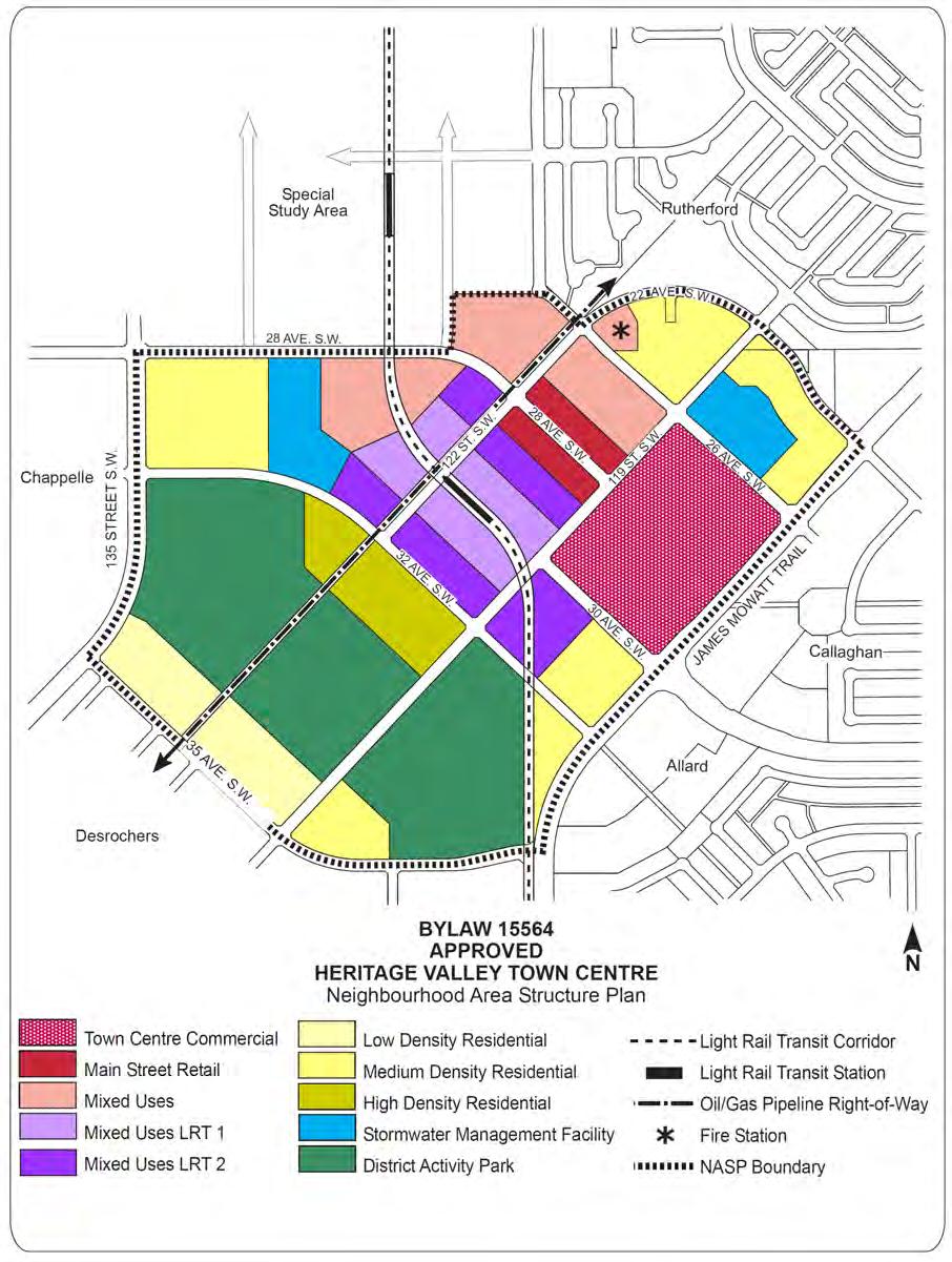
15 12/77 Ensure a compact and integrated urban form that minimizes footprint on land Diverse and Compatible Land Uses Incorporate a variety of land uses in support of the concept of live, work and play Encourage compatible mixed uses, vertically within buildings and/or horizontally within and between land use designations Promote mixed uses within 400 m of the LRT station Ensure permitted and discretionary uses are compatible when mixed use zones are implemented through Section 900 of the Edmonton Zoning Bylaw Locate major trip generating uses closest to the LRT station (i.e. office, medical, institutional, and high density residential) Accessible Street Network Apply a grid-based pattern of streets designed to distribute density, create multiple circulation and access options Design multi-use streets that support various modes of transport such as pedestrians, bicycles, buses, cars, and service vehicles Design streets to reduce vehicle speed in order to encourage the creation of a walkable, urban environment within the Town Centre Integration with Surrounding Communities Establish strong connections with the surrounding communities (including future institutional uses on the Provincial lands to the north) through a series of well-designed and well-connected streets, pedestrian walkways, multi-use trials, open spaces and transit (buses and LRT) Ensure appropriate transition between the Town Centre and the surrounding residential neighbourhoods Integrate the Town Centre into the built fabric of the Heritage Valley Effective Plan Implementation Ensure that the Town Centre is serviced to a full urban standard in an efficient and cost effective manner Monitor the build-out of the Town Centre relative to the arrival of LRT, or interim transit alternatives, to ensure that development is sensitive to market conditions, and that the vision for an urbanized, mixed-use, transit-oriented development is ultimately achieved. 3.3 LAND USE CONCEPT Land Use Concept Characteristics The land use concept for the Heritage Valley Town Centre is shown in Figure 3.0: Land Use Concept. The Land Use Concept designates land at a general purpose level, including: residential, mixed uses
16 13/77 (residential, commercial, office, and institutional), commercial, parks and open space, and public utility. A broad range of individual uses are encompassed in these general designations, including institutional, school and other public related uses. For more detailed information refer to Table 1: Land Use and Population Statistics. The roadway pattern and LRT system set the overall pattern for the neighbourhood. The Plan also provides land use designations from which future zoning is considered for each land use. The primary characteristics of the land use concept are as follows: In support of transit-oriented mixed use development, the intensity of land uses generally transitions from higher to lower, as distance from the LRT station increases. The highest density transit-oriented mixed uses (Mixed Uses LRT 1 and Mixed Uses LRT 2) are located within 200 m of the station. Other relatively lower density uses such as high density residential, mixed uses (MU) and Main Street Retail are located between 200 m to 400 m of the station. At approximately 400 m and beyond, medium and low density residential uses are proposed, in addition to Town Centre Commercial and the District Activity Park. The grid-based vehicular roadway pattern provides a high degree of connectivity and access distributing density and traffic throughout the plan, and thereby contributing to the urbanized pedestrian character of the Town Centre. Design guidelines will ensure that buildings fronting onto public streets contribute to active, accessible and interesting streets. Two major arterial roadways 135 Street SW and James Mowatt Trail border the plan area on the west and east respectively providing two key points of access. Edmonton City Council has approved a conceptual alignment for the South LRT. The LRT system is at the heart of the Town Centre and provides the basis for a transit- and pedestrian-oriented mixed-use centre. The LRT station will be well integrated with surrounding land uses to reinforce the transportation/land use connection. The Town Centre will feature a District Activity Park, which is intended to include a Public High School, a Catholic High School, as well as a multi-purpose Recreation Centre. These uses provide educational, recreational and social resources for the residents of Heritage Valley and will be major nodes of activity. Overall the Town Centre should house approximately 11,835 people, at a net density of 149 units per hectare. The neighbourhood will feature nearly 14 hectares of land for commercial uses, 22 ha of mixed uses and a 30 ha of park/open space. This NASP will be implemented through a combination of Section 900 Special Areas General Provision and standard zones of the Edmonton Zoning Bylaw. The Special Areas General Provision shall apply to the following land uses: Main Street Retail, Town Centre Commercial, Mixed Uses LRT 1, Mixed Uses LRT 2, and Mixed Uses. Standard Bylaw Zones will apply to all other land uses. Direct Control zoning may be used instead of Special Area Zoning to implement the Land Use Concept consistent with the Urban Design policies (section ) and Specific Urban Design Guidelines (section 3.4) of the NASP. Bylaw Nov. 8, 2010

17 14/77 Bylaw November 8, 2010
18 15/77 Table 1: Land Use and Population Statistics (Bylaw 15564, November 8, 2010) LAND USE Area (ha) % of GDA Gross Area Arterial Roadways % Primary Streets % LRT Station* % LRT Corridor* % Pipeline R-O-W % Gross Developable Area % Commercial Town Centre Commercial % Main Street Retail % Parkland, Recreation, School (Municipal Reserve) District Activity Park** % Mixed Uses Fire Station % Infrastructure / Servicing Stormwater Management Facility % Total % Net Residential Area % RESIDENTIAL LAND USE, DWELLING UNIT COUNT, AND POPULATION Land Use Area (ha) Units/ha Units People/Unit Population % of NRA Mixed Uses LRT , ,162 10% Mixed Uses LRT , ,487 15% Mixed Uses , ,365 18% High Density Residential Medium to High Rise Units , ,512 9% Medium Density Residential Low Rise/Medium Density Housing , ,888 36% Low Density Residential Single/Semi-Detached % ,439 11, % Gross Population Density: Net Population Density: Gross Unit Density: Net Unit Density: LDR / MDR / HDR Ratio:*** 2.02%/ 21.57%/ 76.41%/ STUDENT GENERATION STATISTICS Level Public Separate Total Elementary Junior High Senior High Total * Land owners may enter into discussions with the City regarding the LRT station and corridor (i.e. purchase vs. dedication) at the subdivision stage. ** Areas dedicated to Municipal Reserves to be confirmed by legal survey. *** MU LRT 1, MU LRT 2, and MU are assumed to be fully built out as high density residential. Actual development is expected to include a mix of uses.
19 16/ Environment The City requires that Phase I Environmental Site Assessments (ESA) are submitted, reviewed, and endorsed prior to development to ensure that land is suitable for development. Objective NASP Policy Implementation Ensure that the environmental status of the lands within the Heritage Valley Town Centre is suitable for development Ensure that Environmental Site Assessments are complete and up-to-date a) The likelihood, types, and location of environmental concerns that may be present on the lands shall be determined prior to rezoning b) Where necessary, contaminated material shall be removed and disposed off in an environmentally sensitive manner, in accordance with Federal, Provincial, and Municipal regulations Environmental Site Assessments shall be submitted prior to rezoning a) ESAs and any follow-up require sign-off by City Administration prior to the rezoning stage of development b) Site remediation, where necessary, shall be conducted prior to rezoning. An environmental site assessment report verifying the remediation shall be submitted for approval by the City administration prior to the rezoning of the subject lands ESAs and any follow-up require sign-off by City Administration prior to the rezoning stage of development. Rationale Lands within the neighbourhood boundary will be suitable for development and their environmental status confirmed prior to rezoning. Those lands identified as contaminated must undergo remediation according to federal, provincial, and municipal standards. Technical Summary A Phase I ESA, for parcels within the NASP boundary was approved by the City of Edmonton to confirm the Plan area will be suitable for development (see Appendix 1, Table 3: Land Ownership, and Figure 10.0: Environmental Site Overview). Any follow-up items identified by ESAs shall be addressed and signed-off by City Administration prior to the rezoning of the subject areas Pipeline Rights-of-Way and Facilities The Alberta Energy and Utilities Board Pipeline License Register identifies two pipeline transmission facilities within the Heritage Valley Town Centre NASP (see Table 2: Existing Pipeline Transmission Facilities and Figure 9.0: Site Features).
20 17/77 Table 2: Pipeline Information Summary EUB Line No. Company Name Substance Note ATCO Gas and Pipelines Ltd Pembina Pipeline Corporation Natural Gas Located within the plan area. Running through NE ¼ W4 Low vapour pressure Crude Oil Located within the plan area. Running through NE ¼ W4 High vapour pressure Developments must comply with Federal and Provincial legislation or regulation, or Municipal regulation, and Capital Region Board policies with regards to developments along pipelines. At the rezoning stage, a review of applicable government policies will be conducted and any policy/regulation requirements will be fulfilled. Prior to the subdivision stage of development, the exact location of both pipelines will be determined through a survey. There are no well sites in the plan area. Objective NASP Policy Implementation Ensure that development adjacent to pipelines complies with applicable regulations Development adjacent to pipelines shall comply with the following City of Edmonton regulations: Policy Guidelines for the Integration of Transmission Pipelines and Urban Development (1985), and Planning for the Interface of Pipeline Rights-of-Way and the Subdivision of Land (2003) Any relevant Federal, Provincial legislation or regulation, or Municipal regulation, guidelines, policies or Capital Region Board planning policies shall also be respected Figure 3.0: Land Use Concept illustrates how the rights-of-way have been incorporated into the overall development concept. Rationale All applicable regulations will be followed to ensure that development does not encroach on rights-of-way and that the safety of residents is a priority Historical Resources Pursuant to Section 31 of the Historical Resources Act, development proponents and/or their representatives are required to report the discovery of any archaeological, historic period or paleontological resources, which may be encountered during construction.
21 18/77 Objective NASP Policy Implementation If present, identify and protect items with historical significance, such as buildings and areas of cultural significance, in the Town Centre Past and current activities within the Heritage Valley Town Centre shall be reviewed to identify items of historical significance A Historical Land Use Study for the plan area has been approved by Alberta Culture and Community Spirit (ACCS). According to ACCS a Historical Resources Impact Assessment is not required. Rationale According to ACCS, there is a low potential for encountering historical resources within the boundary of the Town Centre. Technical Summary A Historical Land Use Study has been completed for all parcels within the plan boundary (see Appendix 1) Ecology The function and integrity of the ecological network in the Heritage Valley Town Centre NASP area is limited. The plan area is primarily agricultural land and the only ecological network components identified by the City of Edmonton Ecological Network map is a pipeline right-of-way which serves as a corridor. 1 This corridor links the plan area to a tree stand located immediately to the south in the Desrochers neighbourhood and extends towards the Blackmud Ravine to the north. In addition, the plan area contains three residences with treed windrows, a portion of a tree farm and a small naturalized dugout that has been historically modified. These network components provide minimal opportunity for habitat value and likely do not warrant conservation due to negligible ecological significance. For these reasons, a detailed ecological network has not been prepared for the NASP area. Developing a new network is a preferable approach to create connectivity within the NASP area and between network components located within and outside of the plan boundary. From an ecological perspective, the NASP concept includes the following components: a 30 ha District Activity Park site, a pipeline right-of-way (to be developed as a multi-use trail corridor) and two stormwater management facilities (SWMFs) occupying approximately 5.4 ha (see Figure 3.0: Land Use Concept). Due to the isolated location of the tree stand, and the resulting limited wildlife habitat usage, these components are designed to facilitate the movement of small mammals, birds and amphibians. The District Activity Park area includes green space that will provide some habitat opportunities and potentially unobstructed wildlife conveyance from the pipeline corridor to one of the SWMFs. Wildlife species that may utilize this pathway include small mammals such as squirrels and rabbits, and a variety of bird species. The conversion of the pipeline corridor to a multi-use trail will enable connectivity across the entire neighbourhood, although movement across the LRT corridor may be limited to bird species. The corridor 1 City of Edmonton Ecological Network Map. Online: [ Accessed May 25, 2009
22 19/77 will be planted primarily to grass due to pipeline access requirements; however, some tree species may be planted. As per the Land Use Concept, the pipeline corridor will maintain the connection between the plan area and the natural area located within the Desrochers neighbourhood. This connection will help to create wildlife corridors between SWMFs and adjacent natural or naturalized areas. The two SWMFs will be constructed in the northern portion of the plan boundary. They will meet the City s requirements and standards for water quality. These SWMF s will be designed to include naturalized shoreline plantings intended to provide habitat opportunities for wildlife and improve water quality. The enhancement of proposed components within the plan area offers the best opportunity to restore connectivity within the Heritage Valley Town Centre NASP area. The proposed concept increases both the integrity and the function of the ecological network and promotes movement to neighbouring natural areas. The pipeline corridor, park space and the two SWMFs will provide future opportunities for wildlife habitat, forage and movement to occur within an urban environment. Objective NASP Policy Implementation Strengthen Edmonton s ecological network a) The Heritage Valley Town Centre NASP shall be designed to integrate components (e.g. SWMFs, utility rightsof-way, parks and open spaces) to provide habitat and encourage ecological connectivity b) Wherever possible, plantings of native species should be utilized to add to the habitat value of the green space within the neighbourhood c) Relevant City of Edmonton conservation planning and policy documents shall be adhered to (i.e. policy C531) Figure 3.0: Land Use Concept guides the development of the NASP. Rationale In 2007 the City of Edmonton introduced the Natural Area Systems Policy (Policy C531) and the Natural Connections Strategic Plan. These documents focus on shifting conservation of natural areas to include ecological connectivity between natural areas. This policy replaces the pre-existing Policy C467 which focused on conserving individual natural areas on Edmonton s Table Lands. As part of the implementation of these two documents, the City of Edmonton has developed a new type of environmental report called the Phase I Ecological Network Report (ENR). This report is intended to examine networks of natural areas and their connectivity at a broad landscape level.
23 20/ Commercial Main Street Retail (MSR) The intent of the MSR designation is to achieve high quality and pedestrian friendly Main Street development that is well integrated with the surrounding land uses and serves as a destination for the Heritage Valley area. This area will function primarily as a retail service area and retail/service uses will occupy the street level. Office and residential uses may be located above the street level. Approximately 2.6 ha of the plan area are designated as MSR. The following table outlines the potential uses and basic land use parameters for development of MSR. Uses - Commercial - Office - Residential - Institutional Potential Building Types - Small and Medium format retail / commercial building - Office building - Commercial / retail / office building with apartment housing on the second and third storeys Maximum Maximum Density Height 75 units / ha 3 storeys Town Centre Commercial (TC-C) The intent of the TC-C designation is to create a high quality, pedestrian-friendly, and multi-purpose commercial development. It is envisioned to include a mix of retail formats (large, medium, and small), office, entertainment, cultural and institutional uses recognizing the proximity and prominence of the transit node (LRT station and bus facilities) within the Town Centre. Approximately 11.2 ha of the plan area are designated as TC-C. The following table outlines the potential uses and parameters for development of the TC-C site. Uses - Commercial - Office, cultural, government uses - Institutional Potential Building Types - Large, medium and small format commercial/retail - Office building Maximum Density N/A Maximum Height 20 m Policy Objective NASP Policy Implementation Provide opportunity for commercial development to meet the needs of the Heritage Valley area Commercial development opportunities shall be provided to serve the needs of residents located within the Heritage Valley Figure 3.0: Land Use Concept illustrates the location of TC-C and MSR areas. A variety of retail and commercial uses shall be allowed in the Town Centre and implemented through Section 900 of the Edmonton Zoning Bylaw.
24 21/77 Objective NASP Policy Implementation Provide opportunity for integration of commercial, residential and office uses Locate and orient commercial sites to ensure high visibility and convenient access opportunities The MSR designation shall permit development of apartment housing above ground level retail/commercial and office uses Commercial uses shall be located in highly visible and accessible portions of the plan area. The location and configuration of the boundary of the MSR parcel adjoining the Mixed Uses and Mixed Uses LRT 2 parcels is not fixed. Its final location may vary and will be determined at the time of subdivision, based on the following considerations: Accessibility to and from the parcel Site design functionality Figure 3.0: Land Use Concept indicates the location of MSR. The MSR policies shall be implemented through Section 900 (Special Areas) of the Edmonton Zoning Bylaw Figure 3.0: Land Use Concept indicates the location of TC-C along James Mowatt Trail and MSR along 28 Avenue SW. TC-C and MSR are within easy walking distance of the LRT station. Rationale Commercial Opportunities and Location of Commercial Sites The area of TC-C and MSR proposed within the Town Centre is of adequate size to accommodate a range of commercial uses, ranging from small to large format retail. The commercial area is envisioned to be developed as a pedestrian friendly, high quality and multi purpose commercial retail centre aimed at creating a vibrant Town Centre that serves as a destination for the Heritage Valley residents. The public realm created by the Main Street is a critical element in establishing the character and vibrancy of the Town Centre. A well-designed Main Street will function as a focal point and amenity area for the Town Centre. These sites have been located to take advantage of high traffic volumes along James Mowatt Trail and 28 Avenue. The LRT line running through the Town Centre will promote multimodal access and provide pedestrians and transit users with convenient shopping opportunities.
25 22/ Mixed Uses The NASP provides three types of mixed uses within the Town Centre boundary. The purpose of the mixed uses designations is to allow for the development of compatible residential (high and medium density), office, institutional, and business uses in a carefully designed, high quality urban environment. The mixed uses designations incorporate a transitional profile in terms of density and built form, with the highest intensity uses placed closest to the LRT station and progressively lower intensity uses away from the station. It is intended to promote unique development opportunities in order to facilitate creation of a transit oriented, vibrant Town Centre. These areas will function primarily as residential areas with opportunity for retail/service on the ground floor, and commercial/office uses on the ground or upper floors. Approximately 9.62 ha of the plan area is designated as MU. Mixed Uses LRT 1 (MU LRT 1) The MU LRT 1 designation is intended to achieve transit oriented and pedestrian friendly development by incorporating the highest intensity and a mix of uses immediately adjacent to the LRT Station, within 200 m. Approximately 5.2 ha of the plan area is designated as MU LRT 1. The following table outlines the potential uses and basic land use parameters for the development of MU LRT 1. Uses - Residential - Live/Work units - Office uses - Convenience and General Retail - Institutional - Business Potential Building Types - Apartment housing - Apartment housing integrated with institutional / business / office uses - Apartment housing integrated with retail uses (maximum 275 m 2 /ha) - Institutional / business / office building Maximum Density Height 275 units/ha Maximum 8 storeys Minimum 4 storeys Bylaw Nov. 8, 2010 Mixed Uses LRT 2 (MU LRT 2) The MU LRT 2 designation is intended to achieve transit oriented and pedestrian friendly development by incorporating higher intensity and mixed uses primarily within the 200 m, but not greater than 400 m of the LRT Station. Approximately 7.4 ha of the plan area is designated as MU LRT 2. The following table outlines the potential uses and basic land use parameters for the development of MU LRT 2. Uses - Residential - Live/Work units - Office uses - Convenience and General Retail - Institutional - Business Potential Building Types - Apartment housing - Stacked Row Housing, including Row Housing (only if attached to apartment housing) - Apartment housing integrated with institutional / business / office uses - Apartment housing integrated with retail uses (maximum 275 m 2 /ha) - Institutional / business / office building Maximum Density Height 225 units/ha Maximum 6 storeys Minimum 4 storeys
26 23/77 Mixed Uses (MU) The purpose of the MU designation is to allow for transit supportive and pedestrian friendly development within 400 m of the LRT station. Approximately 9.0 ha of the plan area is designated as MU. Potential uses and basic land use parameters for the development of MU are as follows. Uses - Residential - Live/Work units - Office uses - Convenience Retail - Institutional - Business Potential Building Types - Apartment housing - Stacked Row Housing, including Row Housing - Apartment housing integrated with institutional / business / office uses - Apartment housing integrated with commercial uses (maximum 275 m 2 /ha) - Institutional / business / office building Maximum Density Height 175 units/ha Maximum 5 storeys Policy Objective NASP Policy Implementation Promote transit oriented development within the NASP boundary Provide opportunities for mixed use development within the Town Centre Allow flexibility in the development of a) MU LRT 1 uses shall be located immediately adjacent to the LRT station b) MU LRT 2 uses should be located within 200 m around the LRT station, but not further than 400 m c) Other higher intensity uses such as MU and HDR should be located within 400 m around the LRT station a) The MU LRT 1, MU LRT 2, and MU designations shall permit vertical or horizontal mix of residential, office and retail uses b) Mixed uses zoning shall allow for conversion of allowed uses within buildings. For example, conversion of residential to office uses The amount and ratio of the type of Figure 3.0: Land Use Concept indicates the location of mixed uses (MU LRT 1, MU LRT 2, and MU) and HDR uses around the LRT station The mixed uses designations shall be implemented through Section 900 of the Edmonton Zoning Bylaw The mixed uses designations shall be
 shall be flexible and respond to market conditions at the time of development, as well as over the long term. 3.3.7.")
 The NASP s housing mix shall exceed the Council-approved Suburban Housing Mix Ratio for new neighbourhoods (i.e. 65% to 85% LDR and 15% to 35% MDR).")
27 24/77 Objective NASP Policy Implementation mixed uses Provide increased residential densities in support of public transit. development (i.e. residential vs. office vs. institutional vs. commercial) shall be flexible and respond to market conditions at the time of development, as well as over the long term a) Mixed uses (MU LRT 1, MU LRT 2 and MU) allowing medium and high density residential development shall be provided within the plan area b) The NASP s housing mix shall exceed the Council-approved Suburban Housing Mix Ratio for new neighbourhoods (i.e. 65% to 85% LDR and 15% to 35% MDR). implemented through Section 900 of the Edmonton Zoning Bylaw Intensified residential development within the mixed uses designations shall be implemented through Section 900 of the Edmonton Zoning Bylaw. Rationale Provision of mixed uses encourages walkability, supports transit ridership, and increases the viability and vibrancy of the Heritage Valley Town Centre during the day and the evening. The allowable uses under the mixed uses designation are compatible with the theme of the Town Centre, providing flexibility and the opportunity for innovative development Residential The NASP provides three types of residential designations: High Density Residential (HDR) also referred to as Medium to High Rise Units, Medium Density Residential (MDR) also referred to as Lowrise/Medium Density Housing or Row Housing, and Low Density Residential (LDR) also referred to as Single/Semi-detached. The intention is to apply standard zones to these designations. HDR and MDR designations are intended to promote higher density, high quality and transit supportive development within the Town Centre. Approximately 28.3 ha of the plan area are designated for residential uses. Street oriented row housing Bylaw Nov. 8, 2010 Bylaw Nov. 8, 2010 High density residential
28 25/77 High Density Residential Approximately 4.5 ha of the plan area is designated as HDR within approximately 400 m of the LRT station. Through the application of standard zones in the Zoning Bylaw, HDR is intended to allow apartment housing with density up to 225 units per ha. Allowable uses also include stacked row housing at a density of approximately 80 units per ha and row housing at a density of approximately 40 units per ha. It is anticipated that the build-out density will average in the range of 150 units per ha. Medium Density Residential Approximately ha of the plan area is designated as MDR within approximately 800 m of the LRT Station. Through the application of standard zones in the Zoning Bylaw, MDR is intended to allow apartment housing with density up to 125 units per ha. Allowable uses also include stacked row housing at a density of approximately 80 units per ha and row housing at a density of approximately 40 units per ha. It is anticipated that build-out density will average in the range of 90 units per ha. Low Density Residential LDR is intended as a transitional land use to ensure compatibility with the lower density residential uses in the adjacent Desrochers neighbourhood. Approximately 6.0 ha of the plan area are designated as LDR, which will allow for the development of single detached, semi-detached and duplex housing at a density of approximately 25 units per ha. LDR will also allow for a more innovative and intensive form of low density residential development. Policy Bylaw Nov. 8, 2010 Objective NASP Policy Implementation Provide increased residential densities in support of public transit Establish affordable housing in the Heritage Valley Town Centre a) The NASP shall incorporate HDR and MDR designations to provide increased residential densities within walking distance of LRT b) The NASP s housing mix shall exceed the Council-approved Suburban Housing Mix Ratio for new neighbourhoods (i.e. 65% to 85% LDR and 15% to 35% MDR) a) Developments shall comply with the City of Edmonton s affordable housing policies and guidelines b) The NASP shall allow for a wide variety of housing types, with a wide range of price points, to create a more inclusive neighbourhood Intensified residential development of the Town Centre shall be implemented through Sections 100 and 200 of the Edmonton Zoning Bylaw a) City of Edmonton s affordable housing policies and guidelines will be applied to the Town Centre prior to rezoning b) Figure 3.0: Land Use Concept indicates the location of various residential land uses.
29 26/77 Objective NASP Policy Implementation Provide land use transitioning around the periphery of the Town Centre Provide opportunity for innovative single detached housing that promotes housing affordability The NASP shall provide LDR at the southern periphery of the Town Centre to ensure land use compatibility with the lower density residential uses in the Desrochers neighbourhood a) The LDR areas shall provide opportunity for innovative single detached housing b) The NASP shall allow for a more intensive form of single detached housing through the use of various development regulations (i.e. smaller minimum site area and depth; reduced lot width, higher site coverage; etc.) c) The NASP shall provide opportunity for a subjective review of current roadway design standards for the LDR areas within the Town Centre. In order to promote affordability, some roadways may be developed with reduced or alternative standards, provided all essential services are met Figure 3.0: Land Use Concept indicates the location of LDR Opportunity for innovative housing may be pursued through Section 900 (Special Areas) or Direct Control Provision of the Edmonton Zoning Bylaw. Rationale High and Medium Density Residential Development Provision of higher density residential development within walking distance of transit (LRT and buses) supports transit ridership, commercial activities, and aides in creating a more compact, walkable, attractive, and liveable neighbourhood. Suburban Housing Mix Ratio The approved suburban housing mix ratio for new neighbourhoods in the City of Edmonton recommends the provision of 35% low density residential development and 65% medium density residential development. Consistent with the transit-oriented development objective, the Town Centre NASP exceeds this ratio by providing 2.02% LDR, 21.57% MDR, and 76.41% HDR. Establishing higher residential densities optimizes the use of land and results in a more efficient use of municipal infrastructure and facilities. It also supports the use of transit, commercial activities, provision of various housing types, and helps manage the strong demand for multi-family housing in the City s growing suburban neighbourhoods. Bylaw Nov. 8, 2010
")
30 27/ Parkland, Recreation Facilities, Schools and Open Space Approximately 30.0 ha in the Town Centre are designated as District Activity Park. Park development is intended to incorporate several structures such as a multi-purpose recreation centre (which typically includes pools, arenas, gymnasiums, indoor soccer and fitness training area) a Public High School, a Catholic High School, and associated parking. The outdoor components may include a 400 m track with an associated grandstand structure, tennis courts, and a variety of sports fields. Additional potential uses include: a skateboard park, water play area, and sand volleyball court. In addition, the District Activity Park site may provide up to 2 ha of landscaped space for passive recreation purposes (i.e. picnics and unstructured recreation). Asset Management and Public Works Parks will design the layout and develop the District Activity Park site based on the above-noted intent. Two stormwater management facilities (SWMFs) are provided within the plan area. While stormwater facilities are not considered parkland (i.e. Municipal Reserve) they will provide additional opportunities for passive recreation. Policy Well designed stormwater management facility Objective NASP Policy Implementation Provide parkland to support active and passive recreation Develop SWMFs that are visually appealing and physically accessible to residents Ensure enhanced pedestrian and bicycle access across the District Activity Park and into the District Activity Park from surrounding areas The programming of the District Activity Park shall support passive and active recreation activities The SWMFs shall be designed using principles of Crime Prevention Through Environmental Design, accessible through public lands, and not landlocked by private development a) The pipeline right-of-way, LRT right-ofway, and the peripheral streets to the park shall provide multi-modal access to the District Activity Park b) In an appropriate location, an enhanced pedestrian crossing shall be The District Activity Park identified in Figure 3.0: Land Use Concept shall be dedicated as Municipal Reserve at the time of subdivision The locations of SWMFs illustrated in the NASP are conceptual and may be refined prior to rezoning a) Figure 4: Transportation Concept and Figure 5: Pedestrian Network illustrate connectivity to and through the District Activity Park b) The location and design of the pedestrian crossing on 119 Street SW
 Safe and convenient pedestrian connections shall be provided through the park and to the LRT station.")
31 28/77 Objective NASP Policy Implementation Ensure a safe, well-designed and functional design layout of the District Activity Park Dedicate municipal reserves as per the requirements of the MGA. provided on 119 Street SW to connect the east and west sides of the District Activity Park c) Safe and convenient pedestrian connections shall be provided through the park and to the LRT station a) The school building envelopes shall be a minimum 200 m from the pipelines, or as stated in approved applicable regulations and policies b) Adequate building frontage should be provided to accommodate flexible building design, parking access, drop off/pick up areas, and school bus zones Municipal Reserves (MR) owing for the Heritage Valley Town Centre shall be dedicated in full as land, money-in-lieu, or an acceptable combination thereof. shall be confirmed by Transportation Department at the roadway design stage in consultation with AMPW- Parks c) Figure 5: Pedestrian Network conceptually illustrates pedestrian connectivity to and through the District Activity Park The design layout of the District Activity Park developed by AMPW-Parks shall conform to Policies a) and b) Areas dedicated as municipal reserves shall be confirmed by legal survey at the time of subdivision. Rationale The District Activity Park provides a range of opportunities for passive and active recreation for residents and visitors of the Town Centre and the Heritage Valley area Institutional The Town Centre Commercial (TC-C), Main Street Retail (MSR), and mixed uses (MU LRT1, MU LRT 2, and MU) designations allow for the development of institutional uses and civic services to adequately meet the needs of the Town Centre and the Heritage Valley area. Institutional uses, such as a recreation centre, post office, library, government offices, heath care facilities, cultural and religious institutions, community buildings Edmonton Public Library, Riverbend Square and day-care centres should be placed in prominent locations, complementary to the urbanized character of the Town Centre.
32 29/77 For the District Activity Park the intention is to incorporate a multi-purpose recreation centre, a Public High School and a Catholic High School. The Edmonton Public Library has shown interest in locating a library in the Town Centre. A public library requires a site of approximately 0.8 ha (2 acre) and good access for residents within the Heritage Valley area. The Edmonton Public Library is willing to co-locate a branch in the recreation centre. A Mixed Use Site for a proposed Fire Station is located at the intersection of 22nd Avenue S.W. and 26th Avenue S.W. The proposed Fire Station requires a site of approximately 0.61 ha (1.5 acres). Fire Stations have site specific and access requirements such as drive through facilities requiring access to major arterials and to avoid conflicts with LRT crossings. As such, the proposed location of the Fire Station provides excellent access opportunities as it is bound by Primary Street frontage (roadway with arterial function) on both the west and north boundaries of the site. The Fire Station site in Heritage Valley Town Centre will serve the needs of Heritage Valley residents in southwest Edmonton. Provision of other emergency services may be pursued based on needs and funding priorities of the City of Edmonton. The City of Edmonton will pursue opportunities to locate such institutional uses within the Town Centre. Policy Institutional uses should be placed in prominent locations, preferably close to the LRT Station, transit stops and businesses. Emergency services, such as a fire rescue station and emergency medical services shall be located on major arterials that provide convenient and efficient access to service areas. Bylaw Nov. 8, Urban Design The following urban design policies are intended to guide future development within the Town Centre and ensure that the community develops in accordance with the vision of the NASP. Objective NASP Policy Implementation Neighbourhood Level Incorporate transit oriented development principles in the design of Heritage Valley Town Centre Ensure careful integration between LRT (corridor and station) and the built environment The Town Centre shall maximize opportunities for high density mixed use residential developments within 400 m around the proposed LRT station. Building heights should transition highest near the proposed LRT station to lowest at the periphery of the neighbourhood a) The LRT station shall be designed to integrate with surrounding development and complement the character of the Town Centre in scale, quality of materials, finishes, landscaping and the pedestrian environment Figure 3.0 Land Use Concept guides land uses for the Town Centre a), b) The City is encouraged to complete an LRT Station Plan prior to development within MU LRT 1 and MU LRT 2 parcels abutting the LRT station. However, timing of LRT Station Plan shall not impede
33 30/77 Objective NASP Policy Implementation b) Where required, fences within the LRT corridor or station shall be decorative and transparent to ensure appropriate interface with the adjacent land uses. development within these parcels. The LRT Station Plan should comply with the policy of the NASP Ensure good connectivity between the Town Centre and surrounding neighbourhoods Create a safe and secure neighbourhood Promote year-round activities within the Town Centre c) Retail uses within MU LRT 1 and MU LRT 2 should be oriented towards the LRT station/pedestrian walkway(s) d) Safe, direct, and attractive pedestrian connections shall be provided to the LRT station from the surrounding area Streets within the Town Centre should align with the proposed streets in the surrounding neighbourhoods Development shall be encouraged to incorporate the principles of Crime Prevention Through Environmental Design (CPTED) such as natural surveillance (visibility, positive social activities), natural access control (entry and exit points, fences), and natural boundaries (clear ownership, clearly marked private spaces) The Town Centre should be designed in consideration of Edmonton s winter-city climate (i.e. protection from the elements, snow removal, daylight hours, solar access, orientation of buildings, outdoor spaces, travel modes, etc.) c) The NASP policy shall be implemented through Section 900 of the Edmonton Zoning Bylaw d) Figure 5: Pedestrian Network illustrates connections to the LRT station Roadways indicated in Figure 4. 0 Transportation Concept are aligned for connectivity with surrounding neighbourhoods CPTED principles should be incorporated in the design of public or private spaces/facilities at the Development Permit stage Policy should be considered in the Development Permit application stage.
34 31/77 Objective NASP Policy Implementation Streetscape Design Design multi-use streets that support various modes of transport such as pedestrians, bicycles, buses, cars, and service vehicles Design Streets to create a walkable, urban environment within the Town Centre a) Primary streets should be designed as multi-use streets that promote pedestrian activity, cycling, and transit b) Secondary streets shall provide pedestrian connectivity through the provision of sidewalks on one or two sides and appropriate lighting Prominent Primary streets should include the following design features and elements: Wide sidewalks with appropriate buffers to increase walkability Good quality street lighting and furniture (i.e. benches, waste receptacles, bollards, etc.) Street trees and plantings Additional focus on key pedestrian crossings that include pavement markings, changing surface materials, curb extensions, etc. Where appropriate, other traffic calming devices should be integrated into the design of Primary streets, for example onstreet parking a) The NASP policies for the design of Primary streets shall be incorporated in the detailed design of roadways b) The Development Officer shall ensure that the Secondary Streets provide pedestrian connectivity and appropriate illumination at the Development Permit stage The NASP policies for the design of Primary streets shall be implemented at the detailed roadway design stage of development. 2 Primary streets are intended to be the movement corridors for several modes of transportation within the Town Centre, and will provide multiple connections with the surrounding areas. These streets shall promote pedestrian activity as well as accommodate cycling and convenient access to Transit. 3 Secondary streets will be the access and service corridors within the Town Centre. Connections between Primary streets or between individual parcels may be accommodated along these streets.
35 32/77 Objective NASP Policy Implementation Open Space and Pedestrian Circulation Incorporate amenity areas and parks/open spaces integrated with the built form and character of the neighbourhood a) A minimum of three focal points shall be provided within the NASP boundary as follows: i. In a prominent location within TC-C; ii. Adjacent to the LRT station; and iii. At the intersection of Main Street and 119 Street SW Focal points within the Town Centre shall function as an amenity space for people and should comprise of one or a combination of the following elements: public art, seating area, plaza, street furniture, fountain, water feature, fireplace, or other architectural elements. These focal points may be developed on private lands with public accessibility b) Landscaping that enhances the character of the buildings and creates a positive relationship with the buildings should be provided c) Open spaces should be designed to promote its continued use and include features such as trees, flowers, unit pavers, pedestrian lights, benches, trash receptacles, etc d) Open spaces should be designed in consideration of winter city design principles e) Continuity of landscape design elements (i.e. street lights, trees, furnishings, paving, and other elements) should be provided within the Special Area parcels f) For the Special Areas parcels (i.e. MSR, TC-C, MU LRT 1, MU LRT 2, and MU), the NASP policies shall be implemented through Section 900 of the Edmonton Zoning Bylaw. For the MDR and HDR parcels, the Development Officer shall ensure that amenity areas are provided in accordance with the provisions of Section 100 or 200.
36 33/77 Objective NASP Policy Implementation Promote enhanced pedestrian circulation within the Town Centre. Built Form Orient buildings to assist in creating a pedestrian-friendly streetscape. Landscaping shall not impede or block sight lines between motorists and pedestrians, particularly at crossing points g) Crime Prevention Through Environmental Design (CPTED) guidelines should be considered in the design of amenity areas. Pedestrian walkways and spaces should be well lit at night and designed to meet CPTED guidelines a) Open spaces / focal points should be accessible through well-planned pedestrian connections b) Convenient, safe and efficient pedestrian crossings shall be provided c) Pedestrian pathways should include special paving or landscaping to define the connections where practical and appropriate d) The overall circulation system should promote connectivity within the Town Centre and extend to all the surrounding areas with multiple options e) Large surface parking areas should include parking islands with pedestrian walkways to facilitate pedestrian movement a) Buildings should be oriented to align with Primary streets and prominent intersections to create a pedestrianfriendly streetscape and an engaging Figure 5: Pedestrian Network illustrates pedestrian connections within the NASP. For the Special Areas parcels, the NASP policies shall be implemented through Section 900 of the Edmonton Zoning Bylaw. For the MDR and HDR parcels, the Development Officer shall ensure that pedestrian circulation is in conformance with policies a) to e) For the Special Areas parcels, the NASP policies shall be implemented through Section 900
37 34/77 Objective NASP Policy Implementation Provide buildings that feature high quality architecture to help create an urban character environment Design pedestrian friendly streetscapes characterized by active building frontages, human-scale built form, wide sidewalks and pedestrian-oriented landscaping. public realm b) Arrival points and edges should receive special design and architectural treatment to ensure that the development presents an attractive and inviting face to surrounding areas a) Buildings shall be of high quality and be designed in an aesthetically pleasing manner b) Building façades should incorporate design treatments that ensure 360-degree architecture c) Building rooftop mechanical equipments shall be concealed from street view by screening it in a manner that is consistent with the character and finishing of the building d) The amount of surface parking abutting the Primary streets should be minimized a) Developments should provide a transition in building form (height and massing), orientation, and landscaping in relation to surrounding uses b) The massing of long building walls shall be reduced through architectural elements such as columns, ribs, pilasters or piers, changes in plane (e.g., recesses and projections), changes in building finishes, materials and textures, or features that create an identifiable pattern and sense of human scale c) of the Edmonton Zoning Bylaw. For the MDR and HDR parcels, the Development Officer shall ensure that the Development Permit application is in conformance with a) and b) For the Special Areas parcels, the NASP policies shall be implemented through Section 900 of the Edmonton Zoning Bylaw. For the MDR and HDR parcels, the Development Officer shall ensure that the Development Permit application is in conformance with a) to d) The Development Officer shall ensure that the Development Permit applications are in conformance with a) to c).
38 35/77 Objective NASP Policy Implementation Manage off-street parking to complement the urban character of the neighbourhood. Buildings fronting onto a focal point, amenity area, or a Primary Street shall be designed and finished to create an active building frontage. Active building frontages are characterized by entrance features/doorways, wall niches, porches, windows or features that lend visual interest and create a human scale a) Large parking areas shall be broken-up by means of on-site private roads, landscaped islands, amenity spaces, and/or pedestrian walkways b) Parking areas shall be designed for a safe and orderly flow of traffic as well as pedestrians to avoid pedestrian/vehicular conflict and to include appropriate landscaping to reduce the visual impact from public roadways, amenity areas and pedestrians c) Bicycle parking should be located near amenities or building entrances in secure at-grade locations d) Parking, loading and passenger drop-off areas should be easily accessible and designed to minimize pedestrian-vehicle conflicts e) Garbage collection for all buildings shall be located within a structure or enclosure that is architecturally compatible with the project design and screened from street view of any residential site f) Loading dock areas shall be screened from abutting public roadways and uses and designed to ensure that vehicles do The Development Officer shall ensure that off-street parking for future development permit application is in compliance with policies a) to f).

 Signs should be designed in an aesthetically pleasing manner and in harmony with the architecture theme of the respective building. 3.3.11.")
39 36/77 Objective NASP Policy Implementation not encroach onto public or private road right-of-way. Signage Provide signage complementary to the theme of the neighbourhood a) Wayfinding signage shall be provided along pedestrian and cycling routes to encourage safe and efficient movement b) Signs should be designed in an aesthetically pleasing manner and in harmony with the architecture theme of the respective building c) Directional signage is encouraged to provide information at critical locations relating to primary tenants, parking lots, loading zones and pick up areas, entrances, exits and amenity areas For the Special Areas parcels, the NASP policies shall be implemented through Section 900 of the Edmonton Zoning Bylaw. For the MDR and HDR parcels, the Development Officer shall ensure that the Development Permit application is in conformance with the Sign Regulations of the Edmonton Zoning Bylaw. 3.4 SPECIFIC URBAN DESIGN GUIDELINES (SPECIAL AREAS) This section outlines policies to achieve specific design objectives for Main Street Retail (MSR), Town Centre Commercial (TC-C), Mixed Uses LRT 1 (MU LRT 1), Mixed Uses LRT 2 (MU LRT 2), and Mixed Uses (MU). These guidelines combined with section Urban Design shall be implemented through Section 900 (Special Area) of the Edmonton Zoning Bylaw and will apply to the following land uses MSR, TC-C, MU LRT 1, MU LRT 2, and MU. Special Area Zoning is an appropriate implementation tool given the complexity of the Town Centre NASP (i.e. mixed-use, high density, transit-oriented development, and a major retail/commercial component). Wide, pedestrian friendly sidewalk (Source: Burden) A well-designed Main Street
40 37/ Main Street Retail Site Planning and Design 1. Buildings shall be oriented to align with Main Street to create a pedestrian oriented streetscape and an engaging public realm. 2. There shall be no minimum yard requirements. 3. Any uses provided on the ground storey shall be street oriented. 4. A focal point should be provided at intersection of Main Street and 119 Street SW intended to serve as a vista for the Main Street. Examples of focal points include public art, seating area, plaza, street furniture, fountain, water feature, play area, fireplace, etc. Building Design 1. Buildings shall be of high quality and be designed in an aesthetically pleasing manner. Chain architecture should generally be limited to corporate logos and signage. 2. Façades of buildings should be designed to incorporate individualized storefronts through the use of variable building setbacks or other architectural treatments. 3. Primary entrances of individual buildings shall be emphasized through the use of recesses, projections, columns, materials, colours, etc. to make them more visible. 4. Landmark structures (for example steeples, clock towers, chimneys, water fountains and elements, etc.) should be utilized to enhance focal points within the development. Street Character 1. Buildings and site amenities should emphasize architectural elements and façade enhancements, particularly to the first and second levels of a project to create a pedestrian friendly environment. Lower floors should be articulated to add variety, interest and a human scale dimension. Design elements may include: placement of windows to allow for viewing into the building by pedestrians, doorways or entrance features, street furniture, arcades, canopies, wall niches, and/or features that lend visual interest and create a human scale. 2. The massing of long building walls shall be reduced through architectural elements such as columns, ribs, pilasters or piers, changes in plane (e.g. recesses and projections), changes in building finishes, materials and textures, or features that create an identifiable pattern and sense of human scale. Pedestrian Circulation 1. Wide sidewalks shall be provided along Main Street to facilitate pedestrian movement and activities. 2. A pedestrian walkway that establishes a direct connection to the LRT station through the MU LRT 1 and MU LRT 2 sites shall be provided. Roadways and Parking 1. On-street parking shall be provided along the Main Street. 2. There shall not be any off-street parking immediately abutting Main Street. Parking shall be located on the rear side of buildings.


41 38/77 3. Main street shall be designed to efficiently and effectively move traffic through the area while maintaining focus on pedestrian movement. 4. Areas for bicycle parking shall be provided to promote alternative modes of transport. Open Space and Landscaping 1. Pedestrian oriented landscaping shall be provided along the Main Street. It may include street trees, plantings, and street furniture such as benches, waste receptacles, bollards, pedestrian-oriented lighting, etc Town Centre Commercial Site Planning and Design 1. Buildings should be oriented to: a. frame the corners of prominent intersections bordering the site; b. frame major vehicular and pedestrian access points into the site; and c. permit views into the site along the axis of roadways and walkways intersecting the abutting perimeter public roadways. 2. A focal point intended to create a sense of place and an inviting image of the development shall be provided in a prominent location within the site. Examples of focal points include public art, seating area, plaza, street furniture, fountain, water feature, play area, fireplace, etc. 3. No part of the site shall be developed as a fully enclosed shopping mall. The primary means of pedestrian circulation shall be outdoor walkways or sidewalks. Building Design 1. Buildings shall be of high quality and be designed in an aesthetically pleasing manner. Chain architecture should generally be limited to corporate logos and signage. 2. The massing of large format retail stores shall be reduced through architectural elements such as columns, ribs, pilasters or piers, changes in plane (e.g., recesses and projections), changes in building finishes, materials and textures, or features that create an identifiable pattern and sense of human scale. Focal point / outdoor amenity area (Source: Burden) Architecturally enhanced massing 3. Highly visible wall surfaces should be architecturally enhanced and/or landscaped to avoid exposed dead frontages abutting James Mowatt Trail, 30 Avenue, 119 Street and 26 Avenue. 4. Building(s) located at the corner of 30 Avenue and 119 Street should be enhanced architecturally in consideration of this prominent location close to MU LRT 2 and LRT corridor. These buildings

42 39/77 should be placed such that they allow for a strong pedestrian connection from the intersection into the TC-C site. Street Character 1. Private internal roadways shall be provided through the TC-C site. These roadways shall provide vehicular and pedestrian connections between James Mowatt Trail and 119 Street, and between 26 Avenue and 30 Avenue. The alignment of the roadways shall be confirmed at the Development Permit stage. 2. Pedestrian sidewalk with boulevard landscaping shall be provided on one or both sides along the private internal roadways. Pedestrian Circulation 1. A strong landscaped pedestrian connection through the TC-C block, linking James Mowatt Trail and 119 Street, shall be provided to facilitate pedestrian movement towards the LRT station and to Main Street. 2. Enhanced parking islands with walkways shall be provided to facilitate safe pedestrian movement from the parking areas to the stores. Remedial treatments such as raised pedestrian crossings, landscaping, special paving, light or bollards shall be provided at significant points of pedestrian and vehicular crossings. 3. Attractive landscaped building sidewalks shall be provided in front of large format buildings and the fronts of free standing buildings to facilitate pedestrian movement and activities. Roadways and Parking 1. Large parking areas shall be broken-up by means of landscaped islands, on-site private roads, amenity spaces, and/or pedestrian walkways. 2. The amount of surface parking abutting the Primary streets should be minimized. 3. Consider pursuing an agreement to bring Edmonton Transit buses into / through the Site to provide front door service opposed to service at the periphery of the Site. Open Space and Landscaping Parking broken-up by landscaped islands 1. Landscaping along large format buildings shall be arranged in a manner that softens the building edge and creates visual relief. 2. Pedestrian oriented landscaping shall be provided along 26 Avenue SW, 119 Street SW, and 30 Avenue SW. 3. Site entrances along James Mowatt Trail and 28 Avenue, and landscaped edges should receive special design attention to ensure that the development presents an attractive and inviting face to surrounding areas. 4. An integrated landscaping theme should be used to highlight major circulation patterns, pedestrian linkages, and the overall development.

43 40/ Mixed Uses LRT 1 and Mixed Uses LRT 2 Site Planning and Design 1. Site interface with the LRT right-of-way (i.e. station and corridor) should be provided in consideration of the following: adequate building setbacks, building orientation, buffer areas, etc. 2. A focal point shall be provided abutting the LRT station to create a sense of arrival for transit riders. Examples of focal points include public art, seating area, plaza, street furniture, fountain, water feature, play area, fireplace, etc. 3. Buildings should be oriented to align with the Primary streets to create a pedestrian oriented streetscape and an engaging public realm. 4. Direct pedestrian connections to the LRT station shall be provided as shown in Figure 5: Pedestrian Network. These connections should also be linked with other focal points and open spaces to create an integrated pedestrian system. 5. Street-oriented convenience retail uses should be provided in buildings fronting on to the LRT station. 6. Buildings abutting the LRT station block should be oriented towards the station. Building Design 1. Signature buildings of high quality should be located within the MU LRT 1 and MU LRT 2 sites. 2. The maximum length of a building shall not exceed 80 m. 3. Institutional uses of public importance should locate along the Primary streets. Street Character 1. Buildings and site amenities should emphasize architectural elements and façade enhancements, particularly to the first and second levels of a project to create a pedestrian friendly environment. Lower floors should be articulated to add variety, interest and a human scale dimension. Design elements may include: placement of windows to allow for viewing into the building by pedestrians, doorways or entrance features, street furniture, arcades, canopies, wall niches, and/or features that lend visual interest and create a human scale. 2. The development should provide a transition in building height and massing in relation to the surrounding land uses. 3. Based on the podium-tower concept, taller buildings shall be stepped back above the fourth storey level in order to create a human scale street character. Pedestrian Circulation A high quality mixed use building (Source: Burden) 1. Pedestrian connections to the LRT station shall be developed as an enhanced walkway with pedestrian-oriented landscaping. It may include street trees, plantings, and street furniture such as benches, waste receptacles, bollards, pedestrian-oriented lighting, etc.

44 41/77 Parking 1. The amount of off-street surface parking abutting 119 Street, 122 Street, and 32 Avenue shall be minimized. 2. Parking should be provided at the rear of buildings or in below-grade facilities where possible. 3. To further encourage transit ridership, reduced parking requirements may be implemented at the Zoning or Development Permit stage. Open Space and Landscaping 1. In projects involving multiple buildings, amenity areas should be grouped to create a larger amenity area for the residents. Such amenity should be easily accessible from surrounding buildings and be provided along major pedestrian routes. Such spaces may be developed as courtyards or plazas or park spaces Mixed Uses Site Planning and Design 1. Interface with the LRT right-of-way shall be treated in consideration of the following adequate building setbacks, building orientation, buffer areas, etc. 2. The development should provide a transition in building height and massing in relation to the institutional uses in the Special Study Area. 3. Buildings should be oriented to align with the Primary streets to create a pedestrian oriented streetscape and an engaging public realm. Building Design 1. Signature buildings of high quality should be located within the MU sites. 2. The maximum length of a building shall not exceed 80 m. 3. Institutional uses of public importance should locate along the Primary streets. Street Character 1. Buildings and site amenities should emphasize architectural elements and façade enhancements, particularly to the first and second levels of a development to create a pedestrian friendly environment. Lower floors shall be strongly articulated to add variety, interest and a human scale dimension. Design elements may include: placement of windows to allow for viewing into the building by pedestrians, doorways or entrance features, street furniture, arcades, canopies, wall niches, and/or features that lend visual interest and create a human scale. 2. The development should provide a transition in building height and massing in relation to the surrounding land uses. A human scale mixed use building

45 42/77 3. Based on the podium-tower concept, taller buildings shall be stepped back above the fourth storey level in order to create a human scale street character. Pedestrian Circulation 1. Convenient, safe and efficient pedestrian connections, well integrated with the overall neighbourhood network, shall be provided. Parking 1. The amount of off-street surface parking abutting 119 Street SW, 26 Avenue SW, 122 Street SW, and 28 Avenue SW shall be minimized. Any surface parking abutting the Primary streets shall be sufficiently screened from view using landscaping and/or architectural design elements. Open Space and Landscaping 1. In projects involving multiple buildings, amenity areas should be grouped to create a larger amenity area for the residents. Such amenity A grouped amenity area should be easily accessible from surrounding buildings and be provided along major pedestrian route. Such spaces may be developed as formal courtyards or plazas or park spaces. 3.5 TRANSPORTATION CONCEPT The transportation concept for the Town Centre moves away from the City s typical road hierarchy of arterial/collector/local roadways and adopts a grid-based pattern to achieve a street network with a higher degree of connectivity and access. Most roadways within the Town Centre have been labelled Primary streets. These streets are intended to replace functions typical of an arterial or collector roadway (see Figure 4.0: Transportation Concept). Primary streets will be designed to be pedestrian friendly and will encourage interaction between various land uses and multiple modes of transportation. A typical Primary street will be designed with a pedestrian focus and include elements such as wide sidewalks, enhanced pedestrian crossings, on-street parking and multiple connections to premium transit service, both buses and LRT. Intersection spacing has been reduced as has the carriageway for a standard arterial roadway. These elements will improve accessibility, shorten walking distances, provide various route options and mode choices as well as help maintain vehicle speeds through environmental design. The Secondary streets will be designed with a more utilitarian function and will replace functions typical of a collector or local roadway. Secondary streets will provide access to parking areas, minor connection points and access for service vehicles. They may be developed as private or public roadways Arterial Roadway Network The Heritage Valley Servicing Concept Design Brief, originally approved in 2001, recommended an arterial road network that included arterial roadways on the east and west boundary of the Town Centre as well as an additional arterial roadway directly through the Town Centre. This arterial roadways network

46 43/77 has been incorporated in the present Arterial Roads for Development Bylaw # This Bylaw provides a mechanism to cost share the development of the Arterial road network needed to service the entire Heritage Valley area. During development of the NASP for the Heritage Valley Town Centre, the arterial roadway configurations have been amended. Arterial roadways along the east and west boundary have been retained (i.e. James Mowatt Trail and 135 Street respectively); however, the arterial roadway through the centre has been removed. These changes were based on the idea of replacing one large through roadway requiring large intersections and limited access opportunities, with a network of smaller roadways, which reduces intersection requirements and provides more options for access. In this concept, the previously planned 25 Avenue SW (now 30 Avenue SW) is replaced with four east/west options (26 Avenue SW, 28 Avenue SW, 30/32 Avenue SW and 35 Avenue SW) and two north/south options (119 Street SW and 122 Street SW). This roadway network provides several route options should one roadway/intersection be blocked or impeded by higher traffic volumes or collisions. Reducing the width of roadways will also help encourage pedestrian movement and improve pedestrian connections to the LRT station as well as manage desired through movements. Pending approval from City Council, the Arterial Roads for Development Bylaw #14380 should be amended to reflect the adjustments made to the arterial roadways that serve the Heritage Valley area. The proposed amendment is anticipated to delete 25 Avenue SW (now 30 Avenue SW) from the ARA Bylaw schedules and will add the Primary streets, all or in part, that are deemed to replace the function of the deleted east-west arterial Primary Streets A pedestrian oriented street with building frontage (Source: Burden) Primary streets are intended to be the movement corridors for several modes of transportation within the Town Centre, and will provide multiple connections with the surrounding areas. These streets shall promote pedestrian activity as well as accommodate cycling and convenient access to Transit. Appropriate portions of these streets will have building frontage requirements to ensure that buildings are aligned with the streets. Direct vehicular access to individual buildings from the Primary streets shall be minimal. Where possible, access locations shall be combined into joint use accesses. Activity required for service vehicles, such as waste management and deliveries, shall also have reduced opportunities directly from the Primary streets. Access opportunities and service requirements should be directed to the Secondary streets, as detailed in section Primary streets are intended to replace common functions of an arterial roadway or collector roadway and as such, must be designed to accommodate appropriate volumes of traffic as estimated in the associated Traffic Impact Assessment. Most of the Primary streets will be developed with a driving lane in each direction and will allow for parking on one or both sides of the street. A few of the streets will experience higher volumes of traffic and will be developed with up to two lanes of traffic in each direction and may also include on-street parking restrictions to accommodate the volumes. Along the Main Street Retail, pedestrian movements and on-street parking availability will be considered a priority. Inclusion of traffic calming elements may also be introduced to effectively manage vehicle speeds through the concentrated pedestrian areas. This will promote the Town Centre s character as a pedestrian-friendly

47 44/77 community, and assist in creating a sense of place. Road right-of-way widths will be appropriately matched to traffic volumes anticipated along the street, the on-street activity that could be expected (parking, transit stops, bicycle lanes, etc.) as well as the intended land uses of adjacent properties. The following cross section conceptually illustrates the intended character of Primary streets. Conceptual cross section of a Primary street Secondary Streets Secondary streets will function as access and service corridors within the Town Centre. Connections between Primary streets or between individual parcels may be accommodated along these streets. Pedestrian connections will be required on one or both sides of the street, depending on the length and available options, and will include appropriate levels of lighting. These Secondary streets are intended to replace common functions of collector and local roadways. Several points of access will be provided along their length to accommodate access to parking as well as to provide a variety of options for service delivery, such as garbage collection, delivery vehicles, loading zones, etc. Lower volumes of traffic are anticipated as well as reduced vehicle speeds as a result of the number of connection and access points along their length. The Secondary streets may be developed as either public or private roadways. Design features such as rolled-face curbs and commercial crossings may be accepted as well as narrower carriageways. In all cases, the needs for emergency access will be considered a priority and while narrower carriageways may be accepted, consideration will be given to on-street parking availability, turning radii and sightlines at access points Pedestrian and Bicycle Network Streets within the Town Centre will be designed to accommodate multiple modes of transportation with a higher focus on pedestrians and bicycles than a typical suburban neighbourhood. Figure 5.0: Pedestrian Network highlights the network of sidewalks, multi-use trails and walkways, which are intended to provide a high degree of connectivity within the Town Centre. All Primary streets will include a sidewalk on both sides of the street as a minimum. There will be locations, particularly along the Main Street Retail and in the immediate vicinity of the LRT1 and LRT2 land uses, where the sidewalks will be wider than standard walkway widths. The wider sidewalks will be developed in areas with higher levels of pedestrian activity as well as where there are primary connection

48 45/77 corridors, such as connections to the LRT station and connections to the District Activity Park. Other areas, where there is lower pedestrian activity, such as the south side of the neighbourhood along 35 Avenue SW, standard sidewalk requirements will apply. Both arterial roadways, James Mowatt Trail and 135 Street SW, at the boundary of the neighbourhood will include a multi-use trail on one side with a sidewalk on the opposite side. Opportunities for cyclists will be provided along the Primary and Secondary streets. The multi-use trails along arterial roads as well as portions of the LRT right-of-way will provide inter-neighbourhood connectivity. Pipeline corridors within the plan area will also provide connection opportunities to the District Activity Park, the LRT station and both abutting neighbourhoods, Rutherford and Desrochers. Designated bicycle routes may be identified using appropriate signage and markings in order to minimize potential conflicts between vehicles, cyclists and pedestrians. On-street, signed and marked, bicycle lanes will be pursued along 26 Avenue SW and 32 Avenue SW. These roadways have been selected for consideration as they provide direct connections into adjacent neighbourhoods, connect directly to major focal points in or adjacent to the Town Centre and they are away from areas with the highest levels of pedestrian and on-street parking activity, both of which provide challenges for on-street bicycles. Inclusion of on-street lanes will be consistent with the City s Bike Plan, which is expected to be approved by City Council in the fall of Secondary streets within the Town Centre will include a sidewalk on one side as a minimum Edmonton Transit LRT Right-of-Way A well designed pedestrian walkway (Source: Burden) The LRT right-of-way through the Town Centre will be at-grade and is expected to be 19.5 m wide (approximately). There are five locations within the neighbourhood where at-grade LRT street crossings will occur. All these crossings have been considered and reviewed with the associated Transportation Impact Assessment. It is anticipated that the various options available, along with the distributed street network, will allow for all intersections to function well at-grade. The intersection at 30 Avenue and 119 Street may require additional signalization and coordination with the LRT route timing to ensure the westbound direction does not impede movements along James Mowatt Trail, particularly the westbound to southbound left turn movement. The 19.5 m width of the LRT right-of-way may accommodate a multi-use trail. It is recommended that a multi-use trail be included within the right-of-way as it extends north of 122 Street SW, and east of 119 Street SW. A multi-use trail within the LRT right-of-way between 119 Street SW and 122 Street SW is not recommended. This section is anticipated to become a high pedestrian area with narrow spaces between buildings and plenty of LRT activity. As an alternative, bicycle or other multi-use activities may be provided along marked bicycle lanes identified in Section above. Uses within the LRT right-of-way will be further determined at the conceptual design stage, including where uses will compliment connectivity throughout the neighbourhood. The LRT route through the Town Centre (see Figure 4.0: Transportation Concept) is consistent with the Transportation Master Plan currently being reviewed by City Council and being moved forward for
49 46/77 potential approval in the fall of Any changes to the Transportation Master Plan may impact this plan as currently shown and amendments may be required. At the time this plan was prepared, no amendments were anticipated. Dedication of the right-of-way to accommodate the LRT development will be pursued by the Transportation Department by means of subdivision and area development. Of note is that the Transportation Department is currently reviewing policies and procedures to develop measures for costsharing of the required LRT land, similar to how dedication is managed for Arterial roadways. At the time this plan was prepared, there were no current policies or procedures for cost sharing lands dedicated for LRT right-of-way alignments. LRT Station The proposed LRT station has been located centrally within the Town Centre to take advantage of adjacent land uses. This premium service is surrounded by high density development opportunities and several options for business and commercial activity within the mixed uses parcels. Within a 5 minute walk (400m), there is a major commercial node, two schools, a multi-purpose recreation centre, and the area s District Activity Park. The LRT station itself will be planned to integrate with the neighbourhood. Users of this station location are anticipated to originate primarily from within the immediate surrounding developments. Several land uses have been configured within 200m and 400m radii of this station to minimize walking distances and to provide a reliance on transit, and especially LRT, as a primary mode of transportation. Convenient and direct pedestrian connections, including multiple options, will be provided from adjacent buildings and streets. Transfers from LRT to transit buses will occur at the northwest corner of the LRT Station, directly from the Primary street (122 Street SW). Two design options are considered for the station: 1) a central platform, similar to the existing stations to the north, or 2) a central track configuration with exterior platforms. Exterior platforms would allow for direct interface with the adjacent land uses but do come with operational considerations and challenges in additional to higher initial construction costs. During development of a conceptual design for the LRT right-of-way, decisions related to the LRT station design will also be pursued. This design exercise should be completed prior to development and subdivision of the area to ensure there are no restrictions of available options as well as to allow full integration of adjacent land uses and application of the planning principles identified within this neighbourhood plan. As the LRT is extended south, a neighbourhood parking strategy will be required for neighbourhood residents and commercial/office/ retail owners or customers to access on-street parking while limiting use of on-street park and ride activity. This is particularly important as this location does not include a full transit centre for bus activity or a designated park and ride facility. In addition, extension of the LRT into the Town Centre is not within the City s short term project funding priorities. As an alternative to LRT, consideration should be given to an interim extension of Transit service into the Town Centre. A few options could include circulation of transit buses as a shuttle type service connecting the Town Centre to the nearest end point of the LRT on a high frequency service. This could be within the planned LRT right-of-way, if available, or within the existing road network. Alternate technology such as a low-floor-wheeled LRT, trolley, etc may also be considered. Providing any amount of improved service, earlier than a full LRT extension, may generate earlier growth of the Town Centre and may also contribute to higher densities being developed at the initial stages of development. Transit Buses A bus network, for both internal and external neighbourhood circulation as well as support service for the planned LRT station, will be routed using Primary streets. Public transit service will be extended into the
50 47/77 NASP area in accordance with the City of Edmonton Transit System Guidelines and demands. The street network will provide sufficient infrastructure to support effective transit service within the neighbourhood and to external destinations along a variety of options. Transit service will be initiated within the neighbourhood as demands warrant and service delivery becomes economically feasible. Primary streets will be developed to a suitable standard to accommodate transit and will provide a readily accessible service to all areas of the neighbourhood. Many bus routes within the greater Heritage Valley area will take advantage of the transit facilities (i.e. transit centre, park and ride and LRT station) along Ellerslie Road, north of the plan area. As such, the LRT station within the Town Centre will be a more localized transit service will fewer connections to the external neighbourhoods. Route planning will continue to be adjusted in order to determine the number and frequency of service options required to serve the remaining neighbourhood areas being planned Parking Parking for vehicles will be provided through a combination of on-street and off-street locations, both public areas and private areas. To promote transit oriented development, parking requirements for Main Street Retail and Mixed Uses LRT 1 and LRT 2 may be significantly reduced as compared to the requirements under the Zoning Bylaw. Reductions for private off-street parking may be accepted in conjunction with development applications for residential and commercial areas of the Town Centre. In certain areas, where it can be demonstrated the development encourages transit use over vehicle use or where there are overlapping requirements, such as mixed use site development, parking may be reduced. Parking impact studies will be required to provide appropriate justification for any suggested parking reduction and will be reviewed by the Planning and Development Department and the Transportation Department. Primary and Secondary (public or private) streets within the Town Centre boundary will provide opportunities for on-street parking. In areas such as the Main Street Retail, this will be included as a requirement of the roadway design. Parking associated with development of parcels may include use or designation of available on-street locations to account for parking deficiencies as per the Zoning Bylaw. Parking or loading areas will also be a requirement at the northwest end of the LRT station to accommodate both transit buses and a kiss & ride type activity in lieu of a park and ride facility. A park and ride facility is not planned within the Town Centre. Provisions for this activity will be included at the larger LRT Station/ Transit Bus Centre/ Park and Ride facility being developed north of Ellerslie Road, west of 127 Street. When the LRT station within the Town Centre is constructed, a detailed parking analysis of the area will be required and, if necessary, a neighbourhood parking program may be implemented Truck Route The City of Edmonton identifies James Mowatt Trail as a designated truck route. Current planning studies are underway for an interchange at 135 Street and Anthony Henday Drive as well as for an extension of 135 Street south of 41 Avenue SW. Upon completion of these studies, this roadway, 135 Street, may become an arterial of higher significance and as such, the current designation of James Mowatt Trail as a truck route may be amended in the future.
51 48/77 Bylaw November 8, 2010

52 49/77 Bylaw November 8, 2010
53 50/77 Policy Objective NASP Policy Implementation Create a network of streets with a high degree of connectivity Regulate access on Primary streets to minimize pedestrian-vehicle conflicts Create a pedestrian friendly environment within the Town Centre a) The Transportation Concept shall incorporate a fine grain grid-based pattern of streets intended to create a network with a high degree of connectivity and access b) Secondary streets should provide connections between Primary streets or between individual parcels; sidewalks shall be provided on at least one side of the Secondary streets, depending on the length and available options, and should include appropriate levels of lighting c) Where necessary, Secondary streets should be utilized to provide vehicular and service access to mixed uses and multi-unit parcels Individual vehicular access to groundoriented residential units shall not be permitted from Primary streets a) The Primary streets within the Town Centre shall be designed as pedestrian oriented streets through incorporating elements/techniques (i.e. human scale design; traffic calming measures; weather protection, wide sidewalks, short cross walks, pedestrian oriented furnishings, etc.) b) The sidewalks shall be designed to create a pedestrian-friendly streetscape and accommodate the requirements of the adjacent land uses a) Figure 4.0: Transportation Concept illustrates the street pattern b); c) The location and alignment of Secondary streets shall be confirmed at the development permit stage Access points along Primary streets shall be determined at the subdivision or development permit stage Figure 4.0: Transportation Concept illustrates the street pattern. Design of various segments of Primary streets shall be determined during detailed roadway design stage.
54 51/77 Objective NASP Policy Implementation Promote pedestrian access throughout the Town Centre a) The Primary streets within the Town Centre shall facilitate pedestrian movement across the neighbourhood a) Figure 4.0: Transportation Concept illustrates the street pattern. Design of various segments of Primary streets shall be determined during detailed roadway design stage Provide strong connections with the surrounding communities Provide public transit services within the plan area in accordance with City of Edmonton Transit System Guidelines and demands Provide opportunities to reduce the vehicle parking requirement within the Town Centre b) The existing pipeline and LRT rightsof-ways shall be developed to include a paved multi-use (MUT) trail c) The stormwater management facilities shall accommodate pedestrian trails a) The NASP shall establish strong connections with the adjacent neighbourhoods through the use of Primary streets (roadways and sidewalks) and multi-use trails b) The transportation network shall provide opportunities for connection with the institutional land uses on the Provincial lands The design of the Primary streets shall provide sufficient infrastructure to support effective transit service within the neighbourhood and to external destinations The NASP shall provide opportunity for a review of current standards for vehicle parking requirements. Consistent with transit oriented b) Figure 3.0: Land Use Concept and Figure 5.0: Pedestrian Network will guide the future development of the pedestrian network c) Figure 5.0: Pedestrian Network will guide the future development of the multi-use trail network Figure 3.0: Land Use Concept and Figure 4.0: Transportation Concept illustrates the street pattern and connections with the surrounding neighbourhoods Future transit routes will be established based on the proportion of trips to be generated from within the neighbourhood and adjacent areas. This service will be accommodated within the neighbourhood as demand warrants Opportunity for reduced vehicle parking requirement may be pursued through Section 900 (Special Areas) of the Edmonton Zoning Bylaw.
55 52/77 Objective NASP Policy Implementation development, parking requirements for appropriate land uses may be reduced. Rationale Design of streets contributes significantly to the quality and character of a community. Streets designed to accommodate multiple modes of transport are typically more vibrant than single use streets designed to accommodate cars. Pedestrian-friendly streets support social interaction and exchange both vital functions of the Town Centre. Studies suggest that a grid-based street pattern is more conducive to creating a more walkable community. In addition, this pattern has a greater traffic carrying capacity as it allows traffic to disperse across the entire area rather than concentrate it along major roadways. Technical Summary The transportation network for the NASP will be provided in accordance with the requirements of the City of Edmonton s Transportation and Streets Department. 3.6 INFRASTRUCTURE, SERVICING AND STAGING CONCEPT The Heritage Valley Town Centre will be a fully serviced neighbourhood, designed and constructed in accordance with City servicing standards Servicing Concept The sanitary, stormwater, and water servicing schemes are illustrated in Figure 6.0: Servicing Concept. Sanitary Servicing: Sanitary services for the Town Centre will connect into the South Edmonton Sanitary Sewer (SESS SW) system through a sanitary trunk line along James Mowatt Trail. The on-site sanitary network will follow the internal roadway alignment along with associated public utility lots. Stormwater Servicing: The NASP provides two stormwater management facilities (SWMF) in the plan area. These have been located on the basis of natural drainage patterns and pre-development sub-basin drainage boundaries in southwest Heritage Valley. The location and configuration of these SWMFs may be revised at the subdivision and/or rezoning stage of development. Water Servicing: Water servicing for the Town Centre will be extended via the watermains running along James Mowatt Trail. Water servicing within the neighbourhood will be designed to provide peak hour flows and fire flows for high and medium density residential uses, and commercial uses. Water looping will be provided in accordance with the requirements of EPCOR. Any existing water lines operated by the Whitemud Water Co-op will remain operational until the City s water servicing system is extended into the neighbourhood. Servicing of the neighbourhood to a full urban standard will require the Whitemud Water Co-op lines to be phased out in a collaborative manner acceptable to EPCOR, Whitemud Co-op and the developers. Shallow Utilities: Power, gas, and telecommunication services are all located within close proximity to the NASP and will be extended into the plan area as required.
56 53/77 Policy Objective NASP Policy Implementation Ensure that the Heritage Valley Town Centre is serviced to a full urban standard a) Sanitary and stormwater servicing shall be provided in accordance with the approved Neighbourhood Designs Report (NDR) for the Town Centre NASP b) Water servicing to the NASP area shall be provided in accordance with the City of Edmonton Design and Construction Standards and the applicable Water Network Analysis (WNA) to the satisfaction of EPCOR Water c) Shallow utilities shall be extended into the plan area as required a) Approval of engineering drawings and servicing agreements will be required for installation of sanitary and stormwater servicing b) Approval of engineering drawings and servicing agreements will be required for installation of water servicing. An updated WNA will be required prior to the rezoning stage of development c) Installation of shallow utilities will be executed through servicing agreements.

57 54/77 Bylaw November 8, 2010
58 55/ Development Staging The anticipated direction of development for the Town Centre is shown in Figure 7.0: Development Staging. Infrastructure to service the initial stages of the Heritage Valley Town Centre will be extended into the plan area from James Mowatt Trail and 135 Street. The following stages will generally proceed along the Primary streets. Urban expansion will be contiguous, logical, and economical with respect to municipal servicing. Development of individual phases may vary from the actual zoning and subdivision applications depending on contemporary market demands and development efficiencies. Should sufficient demand warrant or engineering design be made more efficient, portions of separate phases may be developed concurrently. Rationale The Heritage Valley Town Centre will be designed in accordance with City of Edmonton servicing standards. Development staging and extension of infrastructure will be contiguous, efficient, and economical while having regard for potential environmental and ecological impacts. Technical Summary Details regarding stormwater drainage and sanitary service schemes for the Town Centre are provided in the associated Neighbourhood Designs Report (NDR) submitted under separate cover by Stantec Consulting Ltd. Water looping will be provided in accordance with the requirements of EPCOR Water Services Inc. A Water Network Analysis has been submitted under separate cover by Stantec Consulting Ltd.

59 56/77 Bylaw November 8, 2010
60 57/77 4 APPENDICES
61 58/77 APPENDIX 1 SITE CONTEXT
62 59/77 LAND OWNERSHIP The Town Centre NASP was prepared on behalf of private developers who own approximately hectares (77%) of land within the NASP boundary. The remaining lands are held by a number of other owners. Current (2009) land ownership is listed in Table 3: Land Ownership below and shown in Figure 8.0: Ownership. Table 3: Land Ownership Titled Owner Legal Description Area in NASP (ha) 1 Private Corporate LOT 1 PLAN PTN. N.W. ¼ SEC LOT 3 BLOCK 1 PLAN Private Corporate LOT A PLAN 7091KS LOT C PLAN 1711 MC LOT D PLAN 1711 MC 3 Private Non-Corporate LOT 1 PLAN Private Corporate PTN. S.E. ¼ SEC Private Non-Corporate LOT B PLAN 7091 KS Government PTN. S.E. ¼ SEC Private Corporate FRAC Private Corporate PTN. NW ¼ Government Private Corporate Lot 1, Block 22, Plan Private Corporate Lot 1, Block 23, Plan Private Corporate Lot 1, Block A, Plan Private Corporate Lot 1, Block 1, Plan Bylaw Nov. 8, 2010
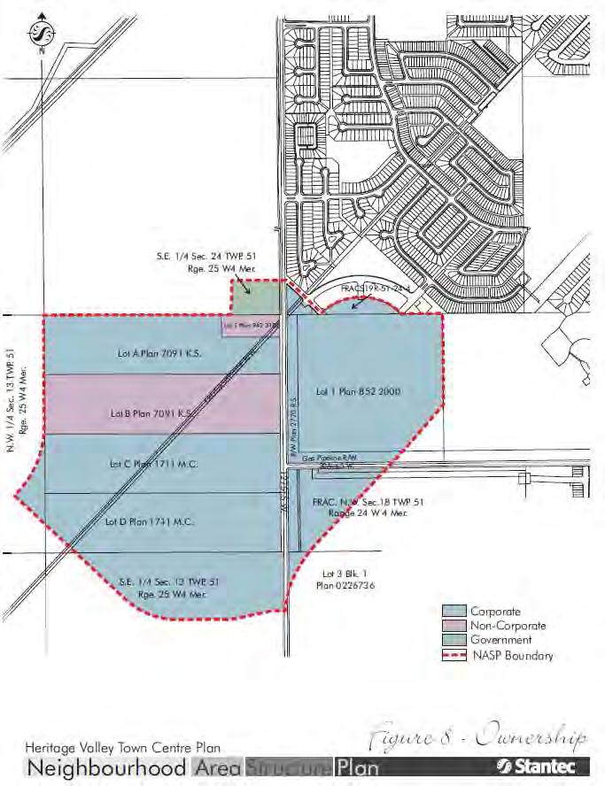
63 60/77

64 61/77 TOPOGRAPHY The topography of the Town Centre is slightly undulating land (see Figure 9.0: Site Features). There are no significant topographic features such as hills, ravines, or bodies of water. The elevations generally vary from approximately 695 m in the north to 697 m in the southern part of the plan area. A north-south drainage-divide line runs along the eastern boundary of the plan area. Since a majority of the NASP area is on the west side of this drainage divide, its stormwater runoff flows into Whitemud Creek; the remainder flows into Blackmud Creek. View looking south ENVIRONMENTAL RESOURCES Ecological Resources City of Edmonton s Inventory of Environmentally Sensitive and Significant Natural Areas (1993) does not identify any environmentally sensitive and significant areas in the Town Centre. A majority of the plan area is covered by agricultural land. Thus, from an ecological standpoint, this area does not pose any constraints. Environmental Site Assessment (Phase 1) As part of the neighbourhood development process and preparation of the NASP, proponents and/or their representatives have completed a Phase I Environmental Site Assessment (ESA) for their respective lands (see Figure 10.0: Environmental Site Assessment Phase I Overview). Findings of the study are summarized in Table 4: Phase I Environmental Site Assessments. It should be noted that updated Phase I ESAs will be required prior to rezoning of land within the Town Centre. Based on existing information, no Phase I or II Environmental Site Assessments have been completed for the remaining lands within the NASP. It should be noted that the Planning and Development Department recommends that individual landowners provide ESAs or disclosure statements prior to the rezoning stage.
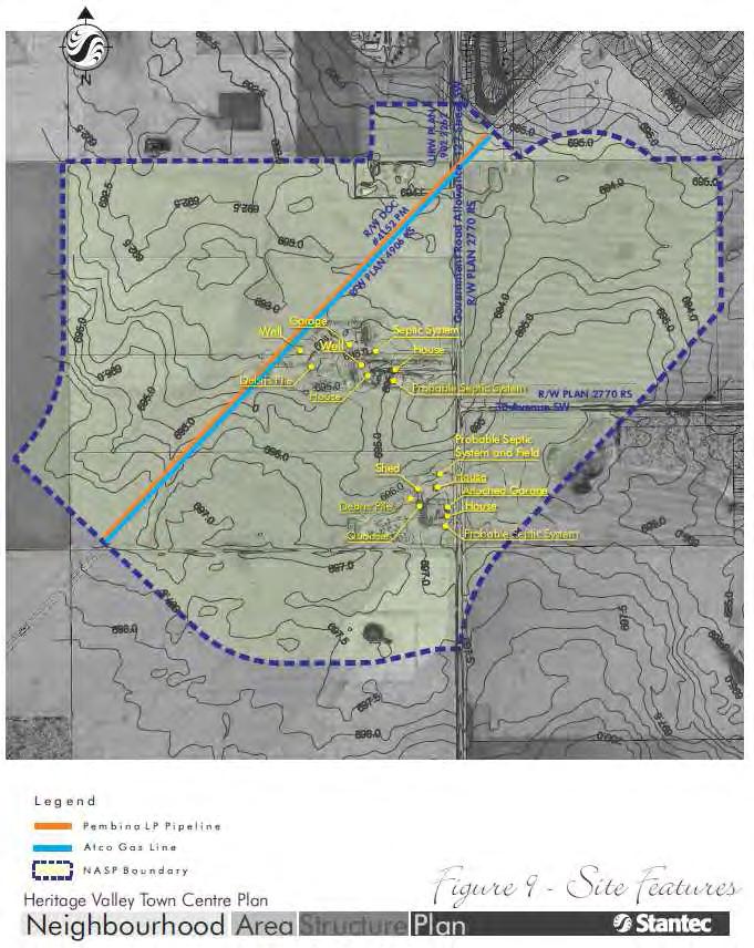
65 62/77
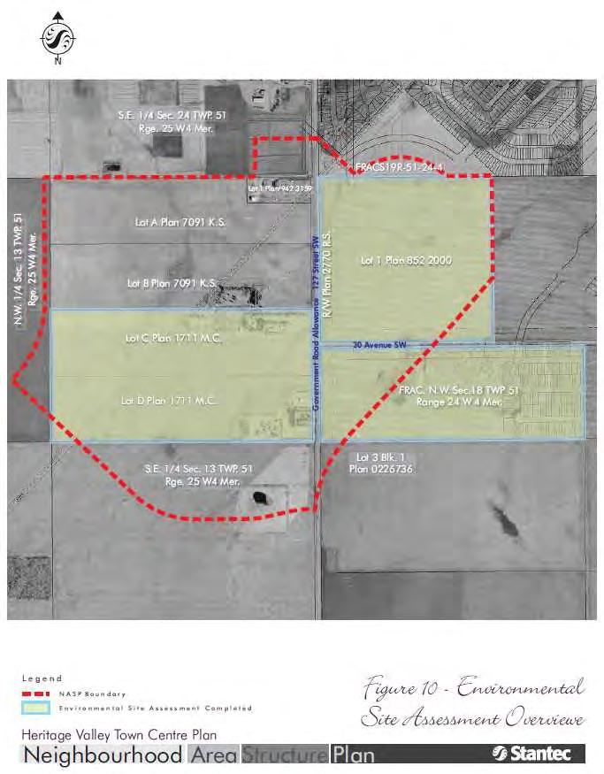
66 63/77
67 64/77 Table 4: Phase I Environmental Site Assessments Location Comments ESA Phase II LOT 1 PLAN No further investigation required Not required Ptn. N.W. ¼ SEC Debris pile to be disposed in an environmentally safe manner Not required Ptn. S.W. ¼ SEC No further investigation required Not required LOT C PLAN 1711 MC Potential concerns to be addressed at the rezoning stage: Farmyard buildings to be further investigated for presence of asbestos, lead-based paint, PCBs, and urea formaldehyde Cisterns, septic systems, and water wells to be decommissioned Automotive parts, tires, concrete debris, barrels, buckets, and refrigerator to be disposed in an environmentally safe manner Telephone poles to be disposed in an environmentally safe manner; soil to be further investigated for the presence of creosote May be required prior to the rezoning stage of development LOT D PLAN 1711 MC Potential concerns to be addressed at the rezoning stage: Farmyard buildings to be further investigated for presence of asbestos, lead-based paint, PCBs, and urea formaldehyde Cisterns, septic systems, and water wells to be decommission Automotive parts, tires, concrete debris, barrels, and buckets to be disposed in an environmentally safe manner Soil staining in the Quonset to be investigated further May be required prior to the rezoning stage of development Note: For more detailed information, refer to ESA Phase I document HISTORICAL RESOURCES A Historical Land Use study was carried out by CT & Associates Engineering Inc. for the entire plan area. This study reviewed past and current activities within the subject site to identify items of historical significance (i.e. buildings, and areas of cultural significance, and potential environmental concerns). The lands designated for development were subjected to an archival search in conjunction with the formulation of the NASP. The findings of the study are outlined below: No buildings of historical significance, cemeteries, churches, or native cemeteries were identified within the study area No historical or existing environmental concerns were identified within the study area There are no known archaeological sites in the study area According to Alberta Community and Culture Spirit (ACCS) there is a low potential for encountering historical resources. These findings indicate that a Historical Resources Impact Assessment (HRIA) is not required for the Town Centre. Pursuant to Section 31 of the Historical Resources Act, development proponents and/or

68 65/77 their representatives are required to report the discovery of any archaeological, historic period, or paleontological resources, if encountered during construction. EXISTING LAND USES As shown in Figure 9: Site Features, the predominant land use in the plan area is agriculture, with scattered farmsteads throughout the plan area. Most of these uses do not present any significant constraints for development. However, an existing house on Lot 1 Plan adjacent to 127 Street Government Road Allowance is significant, and may pose constraints / challenges for development. View looking south Any future development within the NASP boundary is at the discretion of the respective landowners and must comply with the NASP policies and the Zoning Bylaw regulations.
Chappelle Neighbourhood Area Structure Plan
 Chappelle Neighbourhood Area Structure Plan Office Consolidation September 2017 Prepared by: City Planning Urban Form and Corporate Strategic Development City of Edmonton Bylaw 14779 was adopted by Council
Heritage Valley Neighbourhood 12 Neighbourhood Area Structure Plan
 Heritage Valley Neighbourhood 12 Neighbourhood Area Structure Plan Office Consolidation August 2011 Prepared by: Current Planning Branch Sustainable Development City of Edmonton Bylaw 15845 was adopted
Cy Becker Neighbourhood Structure Plan
 Cy Becker Neighbourhood Structure Plan Office Consolidation May 2013 Prepared by: Current Planning Branch Sustainable Development City of Edmonton Bylaw 15747, as amended, was adopted by Council in July
Central and East Neighbourhoods - Hermitage Outline Plan
 Central and East Neighbourhoods - Hermitage Outline Plan Office Consolidation September 2013 Prepared by: Planning and Policy Services Branch Planning and Development Department City of Edmonton The Central
Edgemont Neighbourhood Area Structure Plan
 Edgemont Neighbourhood Area Structure Plan Office Consolidation May 2017 Prepared by: Current Planning Branch Sustainable Development City of Edmonton Bylaw 15717 was adopted by Council in May 2011. In
Westwind Developments Ltd. PIONEER LANDS AREA STRUCTURE PLAN - PROPOSED AMENDMENT
 FEBRUARY 2013 TABLE OF CONTENTS 1.0 BACKGROUND... 1 1.1 Amendment... 1 2.0 LOCATION & CONTEXT... 2 2.1 Land Ownership... 2 3.0 POLICY CONTEXT... 3 3.1 Municipal Development Plan... 3 3.2 Capital Region
Regency Developments. Urban Design Brief. Holyrood DC2 Rezoning
 Regency Developments Urban Design Brief Holyrood DC2 Rezoning Stantec Consulting Ltd. 7-31-2017 1. Overview Regency Developments intends to rezone the lands located at 8510 and 8511 93 Avenue, within the
Ebbers Neighbourhood Area Structure Plan
 Ebbers Neighbourhood Area Structure Plan Office Consolidation November 2016 Prepared by: City Planning Branch Sustainable Development City of Edmonton Bylaw 14079, was adopted by Council in February 2006.
178 Carruthers Properties Inc.
 178 Carruthers Properties Inc. Planning Rationale for 178 Carruthers Avenue Site Plan Control Application June 2014 Table of Contents 1.0 Introduction 2.0 Overview of Subject Property 3.0 Current Zoning
HAYS RIDGE NEIGHBOURHOOD AREA STRUCTURE PLAN
 Melcor Developments Ltd. HAYS RIDGE NEIGHBOURHOOD AREA STRUCTURE PLAN CONSOLIDATED APRIL 2012 Hays Ridge Neighbourhood Area Structure Plan Office Consolidation April 2012 Prepared by: Current Planning
Complete Neighbourhood Guidelines Review Tool
 Complete Neighbourhood Guidelines Review Tool Prepared By: City of Regina Planning Department October 2014 Page 1 of 14 Community Development Review Checklist for Secondary Plans and Concept Plans The
POLICY AMENDMENT AND LAND USE AMENDMENT TUXEDO PARK (WARD 9) CENTRE STREET N AND 26 AVENUE NE BYLAWS 36P2017 AND 234D2017
 CENTRE STREET N AND 26 AVENUE NE BYLAWS 36P2017 AND 234D2017") Page 1 of 11 EXECUTIVE SUMMARY This application proposes to redesignate a single parcel of land in the Community of Tuxedo Park from Commercial Corridor 2 (C-COR2 f1h10) District to Mixed Use Active Frontage
Page 1 of 11 EXECUTIVE SUMMARY This application proposes to redesignate a single parcel of land in the Community of Tuxedo Park from Commercial Corridor 2 (C-COR2 f1h10) District to Mixed Use Active Frontage
ELMVALE ACRES SHOPPING CENTRE MASTER PLAN
 ELMVALE ACRES SHOPPING CENTRE MASTER PLAN Contents 1.0 INTRODUCTION... 2 2.0 LOCATION... 2 3.0 EXISTING CONTEXT... 2 4.0 VISION & GUIDING PRINCIPLES... 2 5.0 LAND USE AND BUILT FORM... 4 5.1 St. Laurent
Keswick Neighbourhood Structure Plan
 Keswick Neighbourhood Structure Plan Office Consolidation January 2018 Prepared by: City of Edmonton Bylaw 15514 was adopted by Council in July 2010. In January 2018 this document was consolidated by virtue
CONTENTS 8.0 LAND USE 8.1 GENERAL LAND USE 8.2 RESIDENTIAL 8.3 MIXED USE 8.4 COMMERCIAL 8.5 EMPLOYMENT LANDS
 8-2 Land Use 8.0 LAND USE CONTENTS 8.1 GENERAL LAND USE 8.1.1 Uses provided for in all Land Use Designations 8.1.2 Uses prohibited in Hazardous Lands, Hazardous Sites and Special Policy Areas 8.1.3 Uses
[PLANNING RATIONALE] For Site Plan Control and Lifting of Holding Zone By-Law 101 Champagne Avenue. May 23, 2014
![[PLANNING RATIONALE] For Site Plan Control and Lifting of Holding Zone By-Law 101 Champagne Avenue. May 23, 2014](/thumbs/75/71599615.jpg "[PLANNING RATIONALE] For Site Plan Control and Lifting of Holding Zone By-Law 101 Champagne Avenue. May 23, 2014") [PLANNING RATIONALE] For Site Plan Control and Lifting of Holding Zone By-Law 101 Champagne Avenue May 23, 2014 Contents 1.0 Introduction... 2 2.0 Site Context... 2 2.1 Adjacent Uses... 2 Figure 1: Site
[PLANNING RATIONALE] For Site Plan Control and Lifting of Holding Zone By-Law 101 Champagne Avenue May 23, 2014 Contents 1.0 Introduction... 2 2.0 Site Context... 2 2.1 Adjacent Uses... 2 Figure 1: Site
ROAD CLOSURE AND LAND USE AMENDMENT SILVER SPRINGS (WARD 1) NORTHEAST OF NOSEHILL DRIVE NW AND SILVER SPRINGS ROAD NW BYLAWS 2C2018 AND 29D2018
 NORTHEAST OF NOSEHILL DRIVE NW AND SILVER SPRINGS ROAD NW BYLAWS 2C2018 AND 29D2018") Page 1 of 19 EXECUTIVE SUMMARY This application proposes redesignating two parcels in the community of Silver Springs from Special Purpose Future Urban Development (S-FUD) District and undesignated road
Page 1 of 19 EXECUTIVE SUMMARY This application proposes redesignating two parcels in the community of Silver Springs from Special Purpose Future Urban Development (S-FUD) District and undesignated road
2136 & 2148 Trafalgar Road Town of Oakville Region of Halton
 PLANNING JUSTIFICATION REPORT 2136 & 2148 Trafalgar Road Town of Oakville Region of Halton Zoning By-Law Amendment Application 2500674 Ontario Inc. November 2016 Table of Contents Page 1.0 Location/Summary
Stillwater Neighbourhood Structure Plan
 SCHEDULE "C" Stillwater Neighbourhood Structure Plan Prepared for: Walton Development and Management LP Mattamy Homes Sunwapta Holdings Corp. Prepared by: Stantec Consulting Ltd. 1161102460 Final Submission
ADMINISTRATION RECOMMENDATION(S) 2018 January 25. That Calgary Planning Commission recommend APPROVAL of the proposed Land Use Amendment.
 2018 January 25. That Calgary Planning Commission recommend APPROVAL of the proposed Land Use Amendment.") Page 1 of 9 EXECUTIVE SUMMARY This land use amendment proposes to redesignate a parcel from DC Direct Control District to Multi-Residential Contextual Grade-Oriented (M-CG) District to allow for multi-residential
Page 1 of 9 EXECUTIVE SUMMARY This land use amendment proposes to redesignate a parcel from DC Direct Control District to Multi-Residential Contextual Grade-Oriented (M-CG) District to allow for multi-residential
13 THORNHILL YONGE STREET STUDY IMPLEMENTATION CITY OF VAUGHAN OPA 669 AND TOWN OF MARKHAM OPA 154
 13 THORNHILL YONGE STREET STUDY IMPLEMENTATION CITY OF VAUGHAN OPA 669 AND TOWN OF MARKHAM OPA 154 The Planning and Economic Development Committee recommends the adoption of the recommendations contained
Welcome. Walk Around. Talk to Us. Write Down Your Comments
 Welcome This is an information meeting introducing the applications for proposed redevelopment of the Yorkdale Shopping Centre site at 3401 Dufferin Street and 1 Yorkdale Road over the next 20+ years,
Urban Design Brief Proposed Residential Development 5219 Upper Middle Road City of Burlington
 Urban Design Brief Proposed Residential Development 5219 Upper Middle Road City of Burlington Prepared by Weston Consulting Prepared for BLOOMFIELD DEVELOPMENT INC. Date: March 2017 Table of Contents 1.
Gold Line Bus Rapid Transit Transit Oriented Development (BRTOD) Helmo Station Area Plan
 Helmo Station Area Plan") Appendix F Gold Line Bus Rapid Transit Transit Oriented Development (BRTOD) Helmo Station Area Plan Introduction and Purpose of the Plan The Gold Line Bus Rapid Transit facility is an eleven-mile dedicated
Appendix F Gold Line Bus Rapid Transit Transit Oriented Development (BRTOD) Helmo Station Area Plan Introduction and Purpose of the Plan The Gold Line Bus Rapid Transit facility is an eleven-mile dedicated
MAGRATH HEIGHTS NEIGHBOURHOOD AREA STRUCTURE PLAN AMENDMENT
 Attachment 2E MAGRATH HEIGHTS NEIGHBOURHOOD AREA STRUCTURE PLAN AMENDMENT NASP JUNE 2008 TABLE OF CONTENTS 1.0 INTRODUCTION...1 1.1 Purpose of Amendment... 1 1.2 Local Setting & Access... 1 1.3 Proposed
URBAN DESIGN BRIEF URBAN DESIGN BRIEF 721 FRANKLIN BLVD, CAMBRIDGE August 2018
 URBAN DESIGN BRIEF URBAN DESIGN BRIEF 721 FRANKLIN BLVD, CAMBRIDGE August 2018 DESIGN BRIEF CONTENTS PART A 1.0 INTRODUCTION 2.0 DESCRIPTION & ANALYSIS OF SITE CONTEXT 3.0 DESIGN CONSTRAINTS AND OPPORTUNITIES
URBAN DESIGN BRIEF. 2136&2148 Trafalgar Road. Town of Oakville
 URBAN DESIGN BRIEF 2136&2148 Trafalgar Road Town of Oakville Prepared By: METROPOLITAN CONSULTING INC For 2500674 Ontario Inc November 2016 TABLE OF CONTENTS Page No. 1.0 Introduction/Description of Subject
*** DRAFT 2 FOR PUBLIC REVIEW ***
 6.7 The area is generally bounded by the Red Hill Valley Parkway to the west, Lake Avenue to the east, the Queen Elizabeth Way (QEW) to the north, and by the properties just south of Queenston Road to
FORMER CANADIAN FORCES BASE (CFB) ROCKCLIFFE SECONDARY PLAN. Official Plan Amendment XX to the Official Plan for the City of Ottawa
 ROCKCLIFFE SECONDARY PLAN. Official Plan Amendment XX to the Official Plan for the City of Ottawa") FORMER CANADIAN FORCES BASE (CFB) ROCKCLIFFE SECONDARY PLAN Official Plan Amendment XX to the Official Plan for the City of Ottawa 1 INDEX THE STATEMENT OF COMPONENTS PART A THE PREAMBLE PAGE Purpose...
FORMER CANADIAN FORCES BASE (CFB) ROCKCLIFFE SECONDARY PLAN Official Plan Amendment XX to the Official Plan for the City of Ottawa 1 INDEX THE STATEMENT OF COMPONENTS PART A THE PREAMBLE PAGE Purpose...
1.0 Purpose of a Secondary Plan for the Masonville Transit Village
 Report to Planning and Environment Committee To: Chair and Members Planning & Environment Committee From: John M. Fleming Managing Director, Planning and City Planner Subject: Masonville Transit Village
Ambleside Neighbourhood Structure Plan
 Ambleside Neighbourhood Structure Plan Office Consolidation May 2016 Prepared by: City Planning Sustainable Development City of Edmonton Bylaw 14057 was adopted by Council in July 2005. In May 2016, this
LAND USE AMENDMENT CORNERSTONE (WARD 3) 60 STREET NE AND COUNTRY HILLS BOULEVARD NE MAP 26NE BYLAW 22D2017
 60 STREET NE AND COUNTRY HILLS BOULEVARD NE MAP 26NE BYLAW 22D2017") Page 1 of 14 EXECUTIVE SUMMARY This Land Use Amendment application covers an area of 43.76 hectares ± (108.14 acres ±) located in northeast Calgary, bound by Country Hills Boulevard NE to the south and
Page 1 of 14 EXECUTIVE SUMMARY This Land Use Amendment application covers an area of 43.76 hectares ± (108.14 acres ±) located in northeast Calgary, bound by Country Hills Boulevard NE to the south and
Hawks Ridge Neighbourhood Structure Plan
 Hawks Ridge Neighbourhood Structure Plan Office Consolidation June 2014 Prepared by: Current Planning Branch Sustainable Development City of Edmonton Bylaw 15547 was adopted by Council in September 13,
YONGE STEELES CORRIDOR SECONDARY PLAN. Young + Wright / IBI Group Architects Dillon Consulting Ltd. GHK International (Canada) Ltd.
 Ltd.") PART A: PREAMBLE 1.0 PURPOSE The purpose of this Secondary Plan is to provide a development framework for intensification of the Yonge/ Steeles corridor including the north side of Steeles Avenue West
PART A: PREAMBLE 1.0 PURPOSE The purpose of this Secondary Plan is to provide a development framework for intensification of the Yonge/ Steeles corridor including the north side of Steeles Avenue West
PORT WHITBY COMMUNITY
 PORT WHITBY COMMUNITY SECONDARY PLAN UPDATE COMMUNITY IMPROVEMENT PLAN URBAN DESIGN GUIDELINES September 2015 DRAFT PROPOSED AMENDMENT NUMBER # to the Whitby Official Plan PURPOSE: The intent of this Amendment
Land Use Amendment in Southwood (Ward 11) at and Elbow Drive SW, LOC
 at and Elbow Drive SW, LOC") 2018 November 15 Page 1 of 10 EXECUTIVE SUMMARY This land use amendment application was submitted by Rick Balbi Architect on 2017 August 31 on behalf of Sable Developments Ltd, and with authorization from
2018 November 15 Page 1 of 10 EXECUTIVE SUMMARY This land use amendment application was submitted by Rick Balbi Architect on 2017 August 31 on behalf of Sable Developments Ltd, and with authorization from
Urban Design Manual PLANNING AROUND RAPID TRANSIT STATIONS (PARTS) Introduction. Station Study Areas
 Introduction. Station Study Areas") 111111 PLANNING AROUND RAPID TRANSIT STATIONS (PARTS) Introduction The ION rapid transit system will link Waterloo, Kitchener and Cambridge through a central transit corridor (CTC). There are a number
111111 PLANNING AROUND RAPID TRANSIT STATIONS (PARTS) Introduction The ION rapid transit system will link Waterloo, Kitchener and Cambridge through a central transit corridor (CTC). There are a number
Stewart Greens Neighbourhood Structure Plan
 Stewart Greens Neighbourhood Structure Plan Office Consolidation June 2017 Prepared by: Planning and Policy Services Branch Planning and Development Department City of Edmonton Bylaw 14674, as amended,
Derry Green Corporate Business Park
 Town of Milton Derry Green Corporate Business Park Urban Design Guidelines BMI/Pace - June 2010 Draft 3 Prepared by: Brook McIlroy Planning + Urban Design / Pace Architects Suite 300-51 Camden Street Toronto,
Official Plan Review
 Official Plan Review Summary Report - The Built Environment August 2014 Part 1: Introduction Planning for a healthy, prosperous and sustainable community is an important goal for our municipality. From
and services The protection and conservation of environmentally significant and sensitive natural heritage features and functions.
 6. Land Use 6.0 Preamble A healthy and livable city is one in which people can enjoy a vibrant economy and a sustainable healthy environment in safe, caring and diverse neighbourhoods. In order to ensure
AREA REDEVELOPMENT PLAN THE WAY WE GROW
 AREA REDEVELOPMENT PLAN THE WAY WE GROW Office Consolidation June 2014 Submitted to the City of Edmonton Planning & Development Department By: Edmonton, AB T5G 0Y5 Phone 780 482-4813 Fax 780 488-4566 Email:
LAND USE AMENDMENT CORNERSTONE (WARD 3) COUNTRY HILLS BOULEVARD AND STONEY TRAIL NE BYLAW 9D2017
 COUNTRY HILLS BOULEVARD AND STONEY TRAIL NE BYLAW 9D2017") Page 1 of 12 EXECUTIVE SUMMARY This Land Use Amendment application covers an area of 54.92 hectares ± (135.71 acres ±) located in northeast Calgary, bound by Country Hills Boulevard NE to the north and
Page 1 of 12 EXECUTIVE SUMMARY This Land Use Amendment application covers an area of 54.92 hectares ± (135.71 acres ±) located in northeast Calgary, bound by Country Hills Boulevard NE to the north and
1.0 PLANNING MARKHAM S FUTURE CONTENTS
 1-1 Planning Markham s Future 1.0 PLANNING MARKHAM S FUTURE CONTENTS 1.1 THE PURPOSE OF THE OFFICIAL PLAN 1.2 THE MARKHAM CONTEXT 1.3 THE REGULATORY CONTEXT 1.3.1 Province of Ontario 1.3.2 York Region
ADMINISTRATION RECOMMENDATION 2016 November 03. That Calgary Planning Commission recommends APPROVAL of the proposed Land Use Amendment.
 Page 1 of 12 EXECUTIVE SUMMARY This Land Use Amendment application covers an area of 75.76 hectares ± (187.20 acres ±) located in northeast Calgary, bound by Stoney Trail NE to the north, 128 Avenue NE
DRAFT Northeast Quadrant of Kipling Avenue and Highway 7 DRAFT AUGUST 29, Goals Land Use. The goals of this Plan are to:
 AUGUST 29, 2017 12.15 Northeast Quadrant of Kipling Avenue and Highway 7 12.15.1 Goals 12.15.2 Land Use The goals of this Plan are to: 12.15.2.1 General Provisions: a) Ensure the development of a compact
KANATA CENTRUM 255 KANATA AVENUE OFFICIAL PLAN AMENDMENT ZONING BY-LAW AMENDMENT
 KANATA CENTRUM 255 KANATA AVENUE OFFICIAL PLAN AMENDMENT ZONING BY-LAW AMENDMENT JUNE 2015 PREPARED BY: FOTENN Consultants Inc. 223 Mcleod Street Ottawa, ON K2P OZ8 (613) 730-5709 PREPARED FOR: Kanata
Outline Plan in Belvedere (Ward 9) at Street SE, LOC (OP)
 at Street SE, LOC (OP)") 2018 October 04 Page 1 of 12 EXECUTIVE SUMMARY This outline plan application was submitted by B&A Planning Group on 2016 July 15, on behalf of Tristar Communities Inc. for 50.14 hectares (123.89 acres)
2018 October 04 Page 1 of 12 EXECUTIVE SUMMARY This outline plan application was submitted by B&A Planning Group on 2016 July 15, on behalf of Tristar Communities Inc. for 50.14 hectares (123.89 acres)
Clairtrell Area Context Plan
 Clairtrell Area Context Plan March 2005 Urban Development Services City Planning Contents 1. Introduction... 4 2. Development Structure... 6 2.1 Streets... 7 2.1.1 Sheppard Avenue and Bayview Avenue...
I615. Westgate Precinct
 I615. Westgate Precinct I615.1. Precinct Description The Westgate Precinct is located approximately 18km west of the Auckland city centre. There are seven Sub-precincts in the Westgate Precinct: Sub-precinct
THE CITY OF WINNIPEG BY-LAW NO. 4/2013. A By-law of THE CITY OF WINNIPEG to adopt a Secondary Plan for the Waverley West Southwest Neighbourhood.
 THE CITY OF WINNIPEG BY-LAW NO. 4/2013 A By-law of THE CITY OF WINNIPEG to adopt a Secondary Plan for the Waverley West Southwest Neighbourhood. THE CITY OF WINNIPEG, in Council assembled, enacts as follows:
PUBLIC OPEN HOUSE HURONTARIO-MAIN CORRIDOR SECONDARY PLAN
 PUBLIC OPEN HOUSE HURONTARIO-MAIN CORRIDOR SECONDARY PLAN Tuesday, February 28, 2012 6pm 9pm 1 st Floor Atrium, City Hall 2 Wellington Street West, Brampton 1 POLICY FRAMEWORK The 2006 Provincial Growth
Mayliewan Neighbourhood Structure Plan Neighbourhood 7 of the Edmonton North Area Structure Plan
 Mayliewan Neighbourhood Structure Plan Neighbourhood 7 of the Edmonton North Area Structure Plan Office Consolidation November 2008 Prepared by: Planning and Policy Services Branch Planning and Development
Appendix C: Interim Mixed-Use Evaluation Criteria
 Appendix C: Interim Mixed-Use Evaluation Criteria C-1 Appendix C: Interim Mixed-Use Evaluation Criteria PURPOSE: The implementation of numerous policies contained within the Master Plan hinges on the creation
THE GARDEN CITY PLAN. City of St. Catharines Official Plan. City of St. Catharines
 THE GARDEN CITY PLAN City of St. Catharines Official Plan City of St. Catharines August 2010 APPROVAL INFORMATION This Official Plan of the City of St. Catharines Planning Area, known as the Garden City
JASPER PLACE. Area Redevelopment Plan
 JASPER PLACE Area Redevelopment Plan Executive Summary Jasper Place is an established community where people live, work and play. The Jasper Place Area Redevelopment Plan (ARP) provides a tool to help
Auburn Bay Community Plan
 Auburn Bay Community Plan Auburn Bay Community Plan Office Consolidation June 2007 Bylaw 15P2003 Approved January 19, 2004 Note: This office consolidation includes the following amending Bylaws: Amendment
HORSE HILL AREA STRUCTURE PLAN
 HORSE HILL AREA STRUCTURE PLAN Office Consolidation September 2015 Prepared by: Current Planning Branch Sustainable Development Department City of Edmonton Bylaw 16353, as amended, was adopted by Council
2.0 A FRAMEWORK FOR SUSTAINABLE GROWTH CONTENTS
 2-2 A Framework for Sustainable Growth 2.0 A FRAMEWORK FOR SUSTAINABLE GROWTH CONTENTS 2.1 MANAGING SUSTAINABLE GROWTH THE VISION TO 2031 2.2 GOALS AND OBJECTIVES 2.2.1 Protecting the Natural Environment
Mill Woods Town Centre Proposed Rezoning LDA
 Mill Woods Town Centre Proposed Rezoning LDA15 0649 The City of Edmonton has received an application for rezoning and an amendment to the Mill Woods Station Area Redevelopment Plan (ARP) for the Mill Woods
Official Plan Review: Draft Built Form Policies
 PG.30.1 REPORT FOR ACTION Official Plan Review: Draft Built Form Policies Date: May 15, 2018 To: Planning and Growth Management Committee From: Chief Planner and Executive Director, City Planning Division
Brampton. Secondary Plan. Review. Bram West. A New Direction in Planning & Public Consultation
 Brampton Bram West Secondary Plan Review A New Direction in Planning & Public Consultation Introduction The Bram West Secondary Plan Review offers an important opportunity for the community to define a
CONTENTS 2.0 A FRAMEWORK FOR SUSTAINABLE GROWTH 2.1 MANAGING SUSTAINABLE GROWTH THE VISION TO GOALS AND OBJECTIVES 2.3 MARKHAM STRUCTURE
 2 A Framework for Sustainable Growth 2.0 A FRAMEWORK FOR SUSTAINABLE GROWTH CONTENTS 2.1 MANAGING SUSTAINABLE GROWTH THE VISION TO 2031 2.2 GOALS AND OBJECTIVES 2.2.1 Protecting the Natural Environment
Port Credit Local Advisory Panel October 20 th Meeting
 Port Credit Local Advisory Panel October 20 th Meeting Focus Of This Evening s Meeting: 1. Hurontario Main Street Higher Order Transit Study 2. Port Credit Mobility Hub & GO Station Parking Structure Study
Charlesworth Neighbourhood Structure Plan
 Charlesworth Neighbourhood Structure Plan Office Consolidation May 2016 Prepared by: City Planning Branch Sustainable Development Department City of Edmonton Bylaw 14010, as amended, was adopted by Council
9 CITY OF VAUGHAN OFFICIAL PLAN AMENDMENT NO BOCA EAST INVESTMENTS LIMITED
 9 CITY OF VAUGHAN OFFICIAL PLAN AMENDMENT NO. 631 - BOCA EAST INVESTMENTS LIMITED The Planning and Economic Development Committee recommends the adoption of the recommendations contained in the following
3. Endorse the LRT vision in transforming Surrey into Connected-Complete-Livable communities, and more specifically, the official vision statement:
 CORPORATE REPORT NO: R038 COUNCIL DATE: February 20, 2017 REGULAR COUNCIL TO: Mayor & Council DATE: February 16, 2017 FROM: General Manager, Engineering FILE: 8740-01 SUBJECT: Surrey Light Rail Transit
OP Council Resolution June 16, Planning and Development Services
 OP-08-01 Council Resolution June 16, 2008 Planning and Development Services Kingsgate Landing Outline Plan Table of Contents 1.0 Introduction 1 1.1 Purpose of Plan 1 1.2 Plan Area Location 1 1.3 Ownership
POLICY AMENDMENT AND LAND USE AMENDMENT KILLARNEY/GLENGARRY (WARD 8) NW CORNER OF RICHMOND ROAD AND 33 STREET SW BYLAWS 1P2015 AND 7D2015
 NW CORNER OF RICHMOND ROAD AND 33 STREET SW BYLAWS 1P2015 AND 7D2015") Page 1 of 13 EXECUTIVE SUMMARY This application seeks to redesignate an RC-2 (Residential Contextual One/Two Dwelling) parcel to MC-Gd72 (Multi-Residential Contextual Grade-Oriented) to allow for multi-residential
Page 1 of 13 EXECUTIVE SUMMARY This application seeks to redesignate an RC-2 (Residential Contextual One/Two Dwelling) parcel to MC-Gd72 (Multi-Residential Contextual Grade-Oriented) to allow for multi-residential
A Growing Community Rural Settlement Areas
 Town of Huntsville Official Plan Review - POLICY BACKGROUND PAPER A Growing Community Rural Settlement Areas BACKGROUND: In addition to the fully municipally-serviced Urban Settlement Area and the Hidden
THE CITY OF SPRUCE GROVE BYLAW C PIONEER LANDS AREA STRUCTURE PLAN AMENDMENT
 THE CITY OF SPRUCE GROVE BYLAW C-797-11 PIONEER LANDS AREA STRUCTURE PLAN AMENDMENT WHEREAS, pursuant to the Municipal Government Act, R.S.A., 2000, c.m-26, a municipality shall adopt Area Structure Plans
CITY COUNCIL AGENDA REPORT
 CITY COUNCIL AGENDA REPORT Subject: COUNCIL MOTION LRT ALIGNMENT REMOVAL FROM THE TRANSPORTATION MASTER PLAN On February 10, 2016 Councillor Hughes provided notice in accordance with Section 23 of Procedure
A General Summary of Land Use Zones 1
 A General Summary of Land Use s 1 2 A General Summary of Land Use s A General Summary of Land Use s Land use zones are used to classify and regulate land development and use. The following descriptions
A. WHAT IS A GENERAL PLAN?
 I. Introduction A. WHAT IS A GENERAL PLAN? A general plan is the planning guideline for the future of a city. It contains goals and policies which regulate urban development, the protection of the natural
URBAN DESIGN BRIEF New Street Burlington, ON
 3225-3237 New Street Burlington, ON MARCH 2017 Prepared for: Royal Living Development Group Inc. Prepared by: adesso design inc. 218 Locke Street South, 2nd Floor Hamilton, ON L8P 4B4 t. 905.526.8876 3225-3237
LAND USE AMENDMENT DOWNTOWN COMMERCIAL CORE (WARD 7) MACLEOD TRAIL SE AND 5 AVENUE SE BYLAW 254D2017
 MACLEOD TRAIL SE AND 5 AVENUE SE BYLAW 254D2017") Page 1 of 10 EXECUTIVE SUMMARY This Land Use Amendment application seeks to redesignate a full downtown block (currently the YWCA site) from a Direct Control based on the CM-2 District (Land Use Bylaw
Page 1 of 10 EXECUTIVE SUMMARY This Land Use Amendment application seeks to redesignate a full downtown block (currently the YWCA site) from a Direct Control based on the CM-2 District (Land Use Bylaw
Bank Street Secondary Plan
 1.1 Introduction The is a guide to the long term design and development of the portion of Bank Street between Riverside Drive and Ledbury Park, and provides direction on land use, built form, design, parking,
Urban Design Brief December 23, 2015 Southside Construction Group Official Plan & Zoning By-Law Amendment
 Urban Design Brief Proposed Official Plan & Zoning By-Law Amendment 3244, 3263 and 3274 Wonderland Road South Southside Group December 23, 2015 TABLE OF CONTENTS Page No. INTRODUCTION... 1 SECTION 1 LAND
City of Grande Prairie Development Services Department
 City of Grande Prairie Development Services Department ROYAL OAKS NORTH OUTLINE PLAN OP-07-03 NW 35-71-6 W6M May 7, 2007 Royal Oaks North Outline Plan TABLE OF CONTENTS 1.0 INTRODUCTION........ 3 1.1 Purpose
5 TOWN OF MARKHAM OFFICIAL PLAN AMENDMENT NO. 144 MILLIKEN MAIN STREET SECONDARY PLAN
 5 TOWN OF MARKHAM OFFICIAL PLAN AMENDMENT NO. 144 MILLIKEN MAIN STREET SECONDARY PLAN The Planning and Economic Development Committee recommends the following: 1. The communication from Brendan O Callaghan,
The West Vaughan Employment Area Secondary Plan Policies
 Part 2: The West Vaughan Employment Area Secondary Plan Policies 2.1 General Policies It is the policy of Council: 2.1.1. That the West Vaughan Employment Area (the WVEA), identified on Schedule 1, will
S o u t h C e n t r a l O u t l i n e P l a n. Leduc Business Park. North Leduc Industrial Area Structure Plan C it y of Led u c.
 Leduc Business Park North Leduc Industrial Area Structure Plan C it y of Led u c Prepared for Farm Air Properties Inc. January, 2007 Table of Contents Page Number 1.0 Purpose of Plan and Definition of
Edward R. Sajecki Commissioner of Planning and Building
 Corporate Report Clerk s Files Originator s Files CD.03.POR DATE: TO: FROM: SUBJECT: Chair and Members of Planning and Development Committee Meeting Date: February 27, 2012 Edward R. Sajecki Commissioner
Public Open House #1
 Public Open House #1 TONIGHT S AGENDA Welcome Project Overview The Big Picture The Station Area The Analysis Thoughts about Future Change Breakout Group Discussions Summation / Next Steps Project Overview
11.4 Highway 400 North Employment Lands Secondary Plan APPROVED BY THE ONTARIO MUNICIPAL BOARD ON NOVEMBER 21, 2011
 11.4 Highway 400 North Employment Lands Secondary Plan APPROVED BY THE ONTARIO MUNICIPAL BOARD ON NOVEMBER 21, 2011 11.4.1 General 11.4.1.1. as approved by the Ontario Municipal Board on November 21, 2011,
North Oakville East Parks Facilities Distribution Plan. November, 2009
 North Oakville East November, 2009 POLICY CONTEXT 1) Purpose a) The purpose of this document is to be a guide for the location, configuration, design and development of the parks system for the North Oakville
Bressa Developments Limited. Planning Justification Report. Revised Draft Plan of Subdivision and Zoning By-Law Amendment
 Bressa Developments Limited Revised Draft Plan of Subdivision and Zoning By-Law Amendment Planning Justification Report Part of Lots 7 & 8 Concession 1, North of Dundas Street Town of Oakville September,
5.1 Site Plan Guidelines
 5. Community Core Guidelines Development of the Community Core will take place by plan of subdivision and site plan approval. It will occur in a phased manner that will reflect the timing of residential
Trafalgar Road Corridor Planning Study Open House
 Trafalgar Road Corridor Planning Study Open House June 24, 2013 6:30-8:30 p.m. Oakville & Trafalgar Rooms Overview The Livable Oakville Plan identifies the lands along Trafalgar Road, between the QEW and
THE CITY OF VAUGHAN BY-LAW BY-LAW NUMBER A By-law to adopt Amendment Number 1 to the Official Plan of the Vaughan Planning Area.
 THE CITY OF VAUGHAN BY-LAW BY-LAW NUMBER 015-2014 A By-law to adopt Amendment Number 1 to the Official Plan of the Vaughan Planning Area. NOW THEREFORE the Council of the Corporation of the City of Vaughan
VICTORIA DOWNTOWN DEVELOPMENT PLANNING
 VICTORIA DOWNTOWN DEVELOPMENT PLANNING A Vision & Guide for the Future Downtown Victoria thrives as a center for the community, offering a great mix of entertainment, culture, business, and recreational
DAVENPORT VILLAGE SECONDARY PLAN
 27 DAVENPORT VILLAGE SECONDARY PLAN 27. DAVENPORT VILLAGE SECONDARY PLAN 1. VISION FOR THE DAVENPORT VILLAGE SECONDARY PLAN Davenport Village, municipally known as 830, 940, 980 and 1100 Lansdowne Avenue,
The Corporation of the TOWN OF MILTON
 Report to: From: Chair & Members of the Administration & Planning Standing Committee W.F. Mann, Director of Planning and Development Date: April 16, 2012 PD 022-12 (Z19/11) Subject: Technical Report Proposed
The Uplands Area Structure Plan. City of Cold Lake, NE & SE W4
 City of Cold Lake, NE & SE 13-63-2-W4 July 2009 1 Contents 1 Background information... 1 1.1 Foreword... 1 1.2 Purpose... 1 1.3 Plan Area and Location... 1 1.4 Ownership... 2 2 Factors Influencing Development...
Welcome to the Oakridge Centre Open House
 Welcome to the Oakridge Centre Open House Why is the City hosting this event? This open house is to inform you of a rezoning application submitted to the City of Vancouver to amend the existing CD-1 (Comprehensive
Bourne Downtown Site Planning
 Prepared for: The Town of Bourne, MA In Cooperation with: Bourne Financial Development Corporation Prepared by:, Inc. June 24, 2009 Table of Contents Introduction and Summary... 1 Site Existing Conditions...
GUIDELINES. Transit Oriented Development. Approved by Edmonton City Council on February 15, 2012 in tandem with City Policy C565
 Transit Oriented Development GUIDELINES Prepared by the City of Edmonton Sustainable Development and Transportation Services Departments Approved by Edmonton City Council on February 15, 2012 in tandem
TERMS OF REFERENCE FOR THE PREPARATION AND AMENDMENT OF RESIDENTIAL AREA STRUCTURE PLANS
 Attachment 3 TERMS OF REFERENCE FOR THE PREPARATION AND AMENDMENT OF RESIDENTIAL AREA STRUCTURE PLANS Prepared by: Planning and Development Department Version 5 (2010) TABLE OF CONTENTS 1 INTRODUCTION
Draft Urban Hamilton Official Plan. Amendment No. XX
 1 of 75 The following text, together with: Draft Appendix A Appendix B Volume 1, Schedule E-1 Urban Land Use Designations Appendix C Volume 1, Appendix A Parks Classification Map Appendix D Volume 1, Appendix
C ity of Grande Prairie Development Services Department
 C ity of Grande Prairie Development Services Department FAIRWAY DEVELOPMENT OUTLINE PLAN OP 08 09 Approved April 6, 2009 Prepared by: Focus Corporation Table of Contents 1.0. Introduction 2 3 1.1. Plan