Land Use Plan. The University of British Columbia Point Grey Campus. Amended to June 2, Pacific Spirit Regional Park
|
|
|
- Corey Watkins
- 6 years ago
- Views:
Transcription
1 Land Use Plan The University of British Columbia Point Grey Campus Amended to June 2, 2015 Chancellor Boulevard University Endowment Lands (UEL) Osoyoos Crescent Pacific Spirit Regional Park NW Marine Drive Crescent Road Memorial Road Walter Gage Road Student Union Blvd Agricultural Road Wesbrook Mall Health Sciences Mall East Mall Main Mall West Mall Lower Mall Agronomy Road Thunderbird Boulevard Stadium Road West 16th Avenue SW Marine Drive F r a s e r R i v e r
2
3 Land Use Plan for The University of British Columbia Point Grey Campus Amended to June 2, 2015
4 Record of Amendments For Land Use Plan UBC Approval Ministry Adoption Purpose of Amendment January 13, 2011 Board of Governors June 12, 2012 Board of Governors April 14, 2014 Board of Governors June 15, 2010 Order in Council June 25, 2010 BC Reg 195/2010 March 1, 2011 Ministerial Order M58-11 August 27, 2012 Ministerial Order M June 2, 2015 Ministerial Order M Minor amendment and adoption of former Official Community Plan as the Land Use Plan for the Point Grey Campus, under Municipalities Enabling and Validating Act (No 3) Part Amendments to Land Use Plan to align policies with the Vancouver Campus Plan (June 2010) and to address the supply of affordable housing, transfers of floor space from UBC Farm and other areas to achieve the population needed to support a complete, sustainable community and to incorporate sustainable community policies and opportunities. Amendments to Land Use Plan to redesignate Area Under Review to Academic (Gage South) and to clarify existing floor space allocation and transfer principles. Amendment to the Land Use Plan to incorporate a new Regional Context Statement to respond to the 2012 Metro Vancouver Regional Growth Strategy Copies of the original Land Use Plan available at the Offices of UBC Campus and Community Planning.
5 Land Use Plan for The University of British Columbia Point Grey Campus CONTENTS 1.0 Introduction Regional Context Summary Goals & Vision 3.1 Vision Statement Goals of a Responsible Community Neighbourliness Objectives Plans & Policies 4.1 Land Use Access Servicing Implementation 5.1 Staging Definition of Terms Schedule A: Land Use Plan Schedule B: Access Schedule C: Plan Areas Appendix 1 to Regional Context Statement: UBC Land Use Plan relationship to the Regional Growth Strategy
6 1.0 Introduction The University of British Columbia (UBC) has a long history of campus planning to support its mandate as a leading academic institution. UBC, with its diversity of academic, research, recreational, residential and cultural activities, is an important local, provincial and international resource. In 2010, the 402 hectare campus served 33,793 full time students (approximately 76% undergraduate), and housed approximately 8500 students and 8000 permanent residents. There are about 18,000 jobs on the campus. The changing needs of UBC have prompted the desire for municipal-style planning to recognize regional objectives, to provide a policy framework for housing and other non-institutional development, and to ensure that development is considerate of its setting and neighbours. The legal context for UBC s Land Use Plan is provided by the Municipalities Enabling and Validating Act (No.3), Part University development in accordance with the provisions of the University Act is the purview of UBC. This Land Use Plan covers the University of British Columbia campus. The boundaries of the UBC Land Use Plan area are shown on Figure 1. This Land Use Plan sets objectives for land use and transportation, particularly in relation to non-institutional development. It is intended to achieve the common objectives of the Greater Vancouver Regional District (GVRD) and UBC to implement the Livable Region Strategic Plan and to sustain UBC s main mission and responsibility as a leading educational institution. The Land Use Plan will guide future decision-making towards creation of a unique university community....to meet GVRD s Livable Region Strategic Plan and to help sustain UBC s academic mission. The Land Use Plan has been prepared and amended through a consultative process involving the UBC campus community, interest groups from both on and off campus, and the public. It is intended that future planning initiatives be carried out through public consultative area plan and development approval processes to ensure conformity with the Land Use Plan objectives and policies. If a portion of this Land Use Plan is held to be invalid by a Court of competent jurisdiction, then the invalid portion must be severed and the remainder of this Land Use Plan is deemed to have been adopted by the minister, in accordance with the Municipalities Enabling and Validating Act (No.3), Part , without the severed section, subsection, paragraph, subparagraph, clause or phrase. 1
7 GVRD s goals are: to protect and maintain the viability of the Green Zone ; to build complete communities with a better balance of jobs, housing opportunities, and services; to foster a compact metropolitan region by encouraging growth within the established metropolitan area and concentrating development in mixed use centres; and to manage transportation in favour of a transit oriented and automobile restrained transportation system. UBC s goals are similarly multidimensional: to promote UBC s academic mission to be a world renowned institution of higher education and research; to provide instruction, research and public service that contributes to the economic, social and cultural progress of the people of British Columbia and Canada, is broadly representative of the fields of knowledge and professional specialities, is known and respected internationally, and is sensitive to the issues of our common global society. to utilize its land resource to support academic activities and to build an endowment through the development of an integrated community in an environmentally sound fashion, consistent with regional objectives. 2

8 UBC Land Use Plan Boundary Figure l: Orthophoto
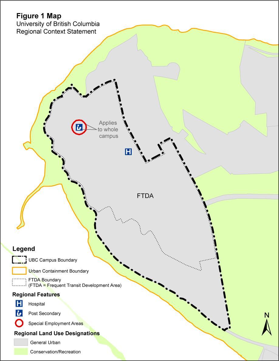
9 2.0 Regional Context Statement REGIONAL CONTEXT STATEMENT Part 10 of the Municipalities Enabling and Validating Act (No.3) (MEVA), requires UBC to include a Regional Context Statement in a Land Use Plan. The purpose of the Regional Context Statement is to describe the relationship between the Land Use Plan and the Regional Growth Strategy (RGS). The Regional Growth Strategy is Metro Vancouver s regional growth plan entitled Regional Growth Strategy: Metro Vancouver 2040, Shaping Our Future. UBC is a world-renowned institution of higher education and research. It contributes to the economic, social and cultural progress of the people of British Columbia and Canada, and is a significant economic development centre in the region, province, and country. UBC is the second largest transit destination in the region. In addition to the academic and research activities, UBC hosts a number of other attractions including nationally important museums and performing arts centres, significant cultural attractions and medical facilities including numerous clinics and a hospital. UBC has developed this Land Use Plan to guide future use of its land resource to support its academic mission and activities, and to build an endowment through the development of an integrated community in an environmentally sound fashion, consistent with regional objectives. UBC is supportive of and responsive to its regional context. The policies of this Land Use Plan are consistent with the five fundamental goals of the Regional Growth Strategy: o o o o o Create a compact urban area; Support a sustainable economy; Protect the environment and respond to climate change impacts; Develop complete communities; and Support sustainable transportation choices. UBC is wholly within the Regional Growth Strategy s Urban Containment Boundary and is a Special Employment Area, as shown on the map below. UBC s planning objectives support regional objectives to focus development in relation to the Frequent Transit Network and, as such, the campus functions as a Frequent Transit Development Area. Appendix 1 to the Regional Context Statement provides information in a tabular form describing the relationship between the Land Use Plan and the Regional Growth Strategy s goals and actions.
10
11 3.1 Vision Through future planning initiatives associated with this Land Use Plan, a special university community will evolve through innovation, renewal, and a quest for excellence based on experimentation and demonstration. It will be a diverse and stimulating place for living, working, and learning in harmony with the environment. The vision for a complete and integrated university community has several key complementary elements. living working learning landscape and activities follow ecological cycles and parallel natural systems. Through an understanding of these processes, learning is fostered. Pacific Spirit Regional Park is a unique resource for learning. stimulating healthy interactive The community benefits from a diversity of people, building forms, uses, landscapes, and interactions. The community mixture reflects the circumstance of a university setting, is stimulating, and is constantly encouraging interaction. The community is a place to live, work, and play where learning is infused in daily life; the academic tradition is reflected in all aspects of the community; and the questioning inherent in learning permeates everyday activities. respect harmony patterns The community is planned, designed, constructed and inhabited with respect for the land and its patterns- natural, cultural, and historical. The community harmonizes with its setting and its academic core. Residents, staff and students join in stewardship for the environment including Pacific Spirit Regional Park. Neighbouring communities are respected. creativity innovation renewal The community evolves continually through creativity, innovation, and renewal. Its leadership demonstration The community leads by example. It provides an opportunity to implement ideas generated within the university, and offers back ideas and interactions. This connection between academic endeavours and community life offers a demonstration to other communities of what is possible. This vision is about a university community, and adjacent park, that strives to balance ecological health, economic viability, and community. These components are all equally valued and, through careful planning, will lead to a community that will serve as a model for living, working and learning in harmony. To carry out the goals of UBC to achieve this vision of what the university community will be like in the long term requires both a plan and the commitment to adhere to and implement that plan. To effectively carry out the UBC Land Use Plan, the future process requires that the community participate in a meaningful way. 6
12 The following sections describe, in general terms, the goals, the principles and the nature of physical responses and processes that flow from them. 7
13 3.2 Goals of a Responsible Community The GVRD has identified this area as part of the Growth Concentration Area. within the Livable Region Strategic Plan. UBC sees community building as an opportunity to help endow, in the long term, the main academic mission of the university. An unparalleled opportunity to meet ecological, economic, and community objectives. This area represents an unparalleled opportunity in the region to foster and shape future land use and development to meet both development and environmental objectives within the regional strategic framework outlined by the GVRD. maximize the effectiveness and equity of public expenditure. Community: Planning will focus on developing a high quality, compact and complete integrated university community. It will contain a diversity of employment, recreational, learning, cultural, and housing opportunities, along with engineering systems and community services, in a manner and setting that promotes a sense of community. It is to be implemented through an ongoing public consultative planning and decision making process. The Land Use Plan must reconcile these three imperatives. These goals are not prioritized and are not to be viewed as mutually exclusive. A balanced result will be achievable. Inherent in this are three fundamental considerations against which future planning and development decisions are to be evaluated ecology, economics, and community. From many perspectives, the objectives are consistent. Ecology: Green Zones designated by the GVRD, specifically the neighbouring Pacific Spirit Regional Park, will be protected for recreation and conservation. As such, the policies of the Pacific Spirit Regional Park Management Plan will be reinforced. The GVRD and UBC will need to ensure the maintenance of a healthy ecosystem throughout the Land Use Plan area and to minimize adverse impact on adjacent areas. Economy: UBC will be able to utilize its land resource for responsible development, consistent with the goals of this Land Use Plan, in order to build an endowment to help sustain its academic mission for the long term. Other economic goals are to effectively use scarce urban land and to 8
14 3.3 Neighbourliness Objectives The university community will fit within adjacent development in the University Endowment Lands and the City of Vancouver, as well as being consistent with objectives for Pacific Spirit Regional Park and in conformity with the Liveable Region Strategic Plan. remain valid and applicable during subsequent planning in pursuit of the vision. This Land Use Plan assumes a continuing planning process. To be respectful of the adjacent communities and Pacific Spirit Regional Park. Ecology: Inter-related land use and transportation systems will be managed to mitigate adverse impact on adjacent areas. Linkages between open spaces and natural areas on- and off-site will be included. Economy: UBC will continue its role as a provider of education, regional employment, facilities, and amenities for surrounding areas. UBC will need to develop and deliver local public services to support residential development. Community: Land uses will be directed to building and servicing the new, complete community. New retail commercial activity will support local activities and not be aimed at drawing additional single purpose traffic to the UBC campus. A mix of housing appropriate for the area will minimize the impact of travel on neighbouring areas. Community services (schools, parks, commercial, etc.) will be staged, concurrent with the residential development, to complement the services in adjacent neighbourhoods. Linkages to the adjacent neighbourhoods and Pacific Spirit Regional Park are an important component of a liveable community. These goals and objectives, developed through a consultative planning process, will 9
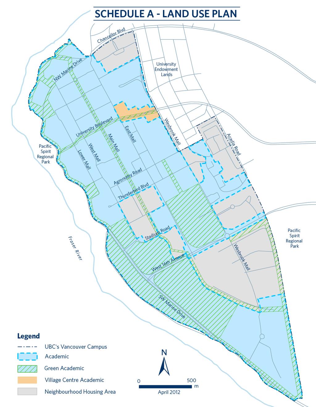
15 4.1 Land Use UBC provides a significant opportunity to build a complete and high quality community that must not be lost. The university will anchor the community, and through its presence and the design of the campus core, will lend the community a distinct character. Through the application of the high standards, leading edge technology, and creativity expected from a major university and its community, the long term objective is to attain a community of a quality and physical character unmatched elsewhere. To achieve great, livable places to work, live, and learn requires imagination and attention to both ecological and community concerns while pursuing financial objectives....great livable places to live, work, and learn. The physical planning principles that flow from the vision statement are first described, and then the land use and development policies are detailed in this section. Ecology: The university community will protect its environmentally sensitive neighbour of Pacific Spirit Regional Park and other special landscapes in order to provide an appropriate environmental perspective, aesthetic, and sensitivity. An ecological framework will be developed for detailed planning, design of services and development. Development will settle comfortably on the land in a manner that respects protected natural systems. Economy: The development pattern, within the constraints of multiple objectives, will optimize the return for UBC from its land resource. While the existing academic core area grows mostly through intensification, the Land Use Plan recognizes the long term potential for additional university related functions like research facilities. Housing will be a significant part of the developable lands. The residential component will provide a broad range of housing opportunities. Community: This will be a university community that is complete with a diversity of uses and services, vibrant, lively and healthy, and a community orientation and sense of neighbourliness. The university community will use the public realm to integrate the access systems and mix of uses. Gathering places, shops, and services will be intermingled with the populations served. New residential areas will focus on a village centre. Housing will cover a broad spectrum of market and non-market housing, and a variety of physical forms, to ensure a multigeneration and lifestyle mix appropriate to a university community. UBC currently provides substantial numbers of student and staff housing in the form of affordable and rental accommodation. The desired physical qualities are humanscaled, medium density and compact. There will be an emphasis on public spaces and green areas both natural and human-made, as well as heritage landscapes and buildings as part of a livable community that reflects the university character. There will be an emphasis throughout the area on safety, primarily through the application of principles of crime prevention through environmental design in decision making. Universal inclusive design to allow equal access to all people is an important 10
16 consideration at all stages of the planning and development process. The future land use and the location of certain design features will generally be as shown on Schedule A: Land Use Plan. This configuration of uses is based on developing a university community which integrates a diversity of uses within the overall land use and transportation structure. Therefore there may be a mix of uses within specific subareas. A description of each of the specific areas and related policies is included in the remainder of this section. While these components will form an integrated whole, for convenience the discussion is organized into the three sections: green areas & green academic, academic, and the residential community. Green Areas & Green Academic Pacific Spirit: Pacific Spirit Regional Park is designated for protection for recreation and conservation in the Pacific Spirit Regional Park Management Plan approved by the GVRD. Development and servicing will ensure maintenance of park values and objectives on these lands and other adjacent Pacific Spirit lands. a) The policies of the Pacific Spirit Regional Park Management Plan will need to be followed by GVRD and UBC in planning and development. b) The planning and development of areas adjacent to Pacific Spirit Regional Park will only be done in a manner that protects the park values contained in the Pacific Spirit Regional Park Management Plan. c) To consider the visual effects of campus buildings on views from Wreck Beach, any proposed project located in either the area west of Lower Mall between Memorial Road and the southern edge of the West Parkade (Building #900), or in the area west of West Mall between Biological Sciences Road and Stadium Road, and that is taller than 30 m above existing grade, is required to provide a view analysis as part of UBC s project review process Green Academic: The Green Academic land use designation identifies those academic lands on campus that will be kept primarily as open areas to support land-based teaching, research, community engagement and athletics as well as ancillary buildings and structures. These spaces are distinguished from other typical academic areas characterized by buildings such as libraries, classrooms, offices, student social space, food outlets, gymnasiums, pools and laboratories. This 'Green Academic' category includes the UBC Farm, the Thunderbird Athletic Fields, Thunderbird Stadium, the Botanical Gardens, that portion of Totem field aligned southward of the southernmost edge of the west parking lot beside SW Marine Drive, and other significant green academic areas including green edges referenced in Section This designation will accommodate structures and land-uses consistent with the approved academic plans for relevant geographic areas. These include the Athletics and Recreation 5 Year Business Plan dated 2008 for the Thunderbird Field and Thunderbird Stadium areas, Cultivating Place dated Dec 2009 for the UBC Farm area, The Botanical Garden and Centre for Horticulture Master Plan 2001 for the Botanical Gardens (including Nitobe Gardens), and the research plan for Totem Field area as coordinated through the Dean of Land and Food Systems, all as amended 11
17 from time to time and received by the UBC Board of Governors. UBC would aspire to construct all buildings and structures that support the Academic Plan programming within the Green Academic designation, including visitors centres, athletics facilities, fieldhouses, teaching facilities, research facilities, farm buildings, and a student residential college, to the highest green building standards with minimal footprints Greenway: A central organizing theme for the academic core is the development of a greenway along Main Mall and University Boulevard that crosses the academic core from east to west and north to south. This is the backbone of a continuous, multi-use, people-oriented corridor that extends through the whole Land Use Plan area to promote linkages between the various uses, destinations, and adjacent green edges. a) A greenway corridor will be developed following the general alignment shown on Schedule B: Access Roads &Transit. b) The design, as specified in future area and design plans, will vary depending on local context and conditions, but will have a substantial green component (although this will vary from a more urban treatment in the academic core to a more natural approach towards the south campus). c) The width and design of the greenway will give priority to pedestrians and cyclists and, in some cases, will accommodate service and private vehicles without conflict. d) UBC will need to coordinate development of the greenway with adjacent jurisdictions including the GVRD and the City of Vancouver. The greenway will incorporate some adjacent areas, such as the tree lots north and southeast of the stadium, for tree preservation. It will also include such other adjacent features as historic buildings or tree stands to enhance the provision of mixed services as part of the public realm Tree Guideline Areas: The Land Use Plan area has significant stands of natural vegetation. While not all can be retained in meeting plan goals for development, those areas designated on Schedule C: Plan Areas as tree guideline areas are to receive further attention through the area planning process or project review. a) Where possible, significant single and mixed species tree stands will be incorporated into the net site area of development sites. The maximum net density for these sites will be calculated incorporating the treed area into the density calculation. b) Those treed areas to be retained will be incorporated into site planning in a manner so that their size, configuration, location, and drainage will ensure the treed areas remain an ecologically viable stand size and will be wind-firm Tree Management Plan: Tree planting and management is required to augment retained stands of natural vegetation. a) A tree management plan will be prepared as part of the area planning process to ensure the long term viability of green edges and retained natural vegetation and to provide street and other planting. b) Any viable mature trees over 15cm calliper dbh (diameter at breast height) that must be removed during the course of residential development in 12
18 neighbourhoods will be replaced on campus at a ratio of 1:1, using species appropriate to the setting, and allowing trees to be sited as appropriate through the campus Green Edges: Green edges are designated in various areas to provide a sense of a community in a forest setting, a natural edge to roadways, wildlife habitat, and to contribute to protecting the integrity of Pacific Spirit Regional Park. a) Green edges will be maintained along North West Marine Drive between the north end of West Mall and southward to the southern end of campus; along both sides of 16 th avenue between SW Marine Drive and East Mall; along the south side of 16 th Avenue between Wesbrook Mall and the eastern UBC boundary at Pacific Spirit Regional Park; and southwards from that point along the edge between Pacific Spirit Regional Park and UBC between 16 th Avenue and the southern end of campus. These areas fall within the Green Academic land use designation shown on Schedule A: Land Use Plan. b) The width and treatment of these green edges, to be defined in future area plans (which incorporate the findings of detailed environmental assessments) and a tree management plan will be determined by the need to maintain a sustainable treed space which meets ecological, buffering and aesthetic objectives. c) The nature of these spaces will vary, ranging from the more manicured spaces along Marine Drive west of the main campus (by Vanier, for example), to the more natural vegetation of areas west of the President s House and in the south campus along SW Marine Drive and adjacent to Pacific Spirit Regional Park. d) These green edges will connect to the greenway and their design will be combined with adjacent open spaces such as Totem Park. Academic Academic: The Academic land use designation identifies those parts of campus to be used for teaching, research, and other uses needed to support the academic mission of the university and academic life. These uses would include but not be limited to: academic and medical buildings, classrooms, libraries, offices, recreation facilities, research facilities, student social space, support services, administration buildings, parkades, cultural facilities, student residences, research laboratories, campus-as-a-living laboratory projects, commercial services needed by the academic community (e.g. bookstore, conference centre, hotels, food services, retail and service commercial), multi-tenant research and service facilities, and UBC support services (e.g. plant and utility facilities, district energy systems, fire, police and ambulance facilities, power substations, transit facilities, and future rapid transit). Green spaces, courtyards and plazas will also be included to enhance campus life, social and study space, beautification, recreation, and circulation. In addition, there are significant cultural facilities such as an art gallery, concert hall, and gardens. The following policies will apply throughout the academic lands: a) This area is for the consolidation of future academic and institutional uses through selective redevelopment and infill. 13
19 b) There will be mixing of uses throughout the campus, i.e. academic, cultural, residential, and commercial (bookstore, university-oriented conference centre, food services, multi-tenant research facility, etc.). c) The height of the non-institutional development in the academic core will depend primarily on detailed urban design and site planning considerations, such as the need to minimize adverse impacts on adjacent sites and retain views, but will not exceed 53 metres. Institutional development should respect this height limit. d) Open space areas outside the greenway will provide green space and an appropriate university character North Campus: The academic area north of NW Marine Drive contains academic buildings, the Museum of Anthropology, and Green College. There are significant constraints on development because of its relation to the cliffs. The intent of policy in this area is to control new development to minimize potential impact on the adjacent park lands and to protect UBC facilities. The following policies will apply: a) Further development will be subject to the policies outlined in the Neighbourhood Plan, which sets the protection of Pacific Spirit Regional Park as a priority objective Village Centre Academic: This area is the main gateway to the academic campus and will provide a central place on campus that welcomes and engages students, faculty, staff, alumni, residents and visitors. The mix of uses in this area will combine to create a vibrant part of campus that is lively day and night, on weekends and year round. This mixed-use centre, supported by year-round housing, will have a wide range of opportunities for meeting people, relaxing and enjoying university campus life, thus encouraging people from all groups on campus to come to this area. This area will be developed in accordance with the following policies: a) Shops and services will be oriented to the day and evening needs of the university population. Uses may include but are not limited to restaurants and fast food outlets (with substantial outdoor seating); personal services such as hair salons, cleaners, travel agents, photocopy shops; offices; convenience groceries, and other specialty retail shops selling goods like books, art, bicycles, clothing or music. b) Individual businesses along University Boulevard are intended to be small scale. Shops and services will be located along the length of the University Boulevard streetscape until reaching the alumni centre on the north side, where different mechanisms for engaging and welcoming the campus community at grade will be employed, and to East Mall on the south side. Strong at-grade connection between the new alumni centre and the new Student Union Building will be encouraged. A building height of 6 storeys will be permitted along University Boulevard, with flexibility to exceed that number of storeys for design or program reasons, to a maximum of 8 storeys. Weather protection will be provided along streetscape frontages. c) This area will emphasize transit, pedestrians, and cyclists as part of the greenway. It will favour outdoor areas for restaurants, substantial glazing, and individual entrances. 14
20 d) The area will be designed to accommodate trolley bus service, the campus shuttle bus, and future rapid transit. e) Housing on University Boulevard will be year-round rental housing and will be designed to be small, affordable units. f) The buildings and public realm will be required to meet high quality design expectations, to reflect the university s stature as a globally significant centre of academic and research excellence. Residential Community Residential Objectives: It is the objective of the Land Use Plan that residential development support establishment of a community with strong links between the academic and residential areas for the mutual benefit of both areas and to reduce the need to travel to and from UBC. In order to achieve this objective: a) Any increase in the full-time undergraduate student population at UBC should be met with an increase in housing provided specifically for students, whether by UBC, other academic institutions, non-profit groups, the private sector or other organizations, to maintain not less than a 25% ratio of housing specifically for undergraduate students to full-time undergraduate students. UBC will also aspire to provide capacity to accommodate student housing for up to 50% of the current (2010) full-time student population. New student beds are built subject to fluctuating availability of debt capacity, and financial capacity within the university, and sufficient demand from students, and support of the necessary combination of project characteristics such as unit mix. b) The Land Use Plan sets as a goal that not less than 50% of new market and non-market housing serve households where one or more members work or attend university on the UBC campus. Achievement of this goal will be assessed during the local area planning process and will be reviewed in five years from adoption of the Land Use Plan. In undertaking an assessment and review of progress towards all housing goals, consideration will be given to both completed units and planned development Neighbourhood Housing Areas: The Schedule A: Land Use Plan designates Neighbourhood Housing Areas throughout the campus, including a major portion of the south campus, significant areas immediately south of existing housing areas in the middle campus (extending from SW Marine Drive to Acadia), and near the student recreation centre on Wesbrook Mall Neighbourhood Housing The Neighbourhood Housing Areas will provide a range of rental and long-term lease housing to the broader community (noninstitutional housing). Units will be a range of sizes and tenures to include families with children, as well as singles and couples with no children. a) Neighbourhood Housing areas will be the subject of an area planning process prior to approval of non-institutional development. Achievement of the goals and targets set out in will be assessed during the area planning process and will be reviewed in five years from adoption of the Land Use Plan. b) It is the objective of this Land Use Plan that over time a significant proportion of 15
21 future housing will be accessible to those who work or attend university on the UBC campus. In order to achieve this objective, housing will be of a range of types, unit sizes and densities, and therefore range of housing prices and tenures. Progress towards achievement of this objective will be measured in relation to the following guideline: 20% of new residential dwellings will be rental housing, of which not less than half will be non-market housing that may include staff, faculty, cooperative, social or other special housing needs. This housing will be locationally integrated into the community. c) The maximum average floor space ratio will be 2.5 net area. No individual site will have a floor space ratio greater than 3.5 net area. For clarity, this average density may be achieved through variable allocation across neighbourhood housing areas. d) Housing will generally be at least 6 storeys. The maximum height is 53 metres and it may be increased to 65m for certain sites subject to confirmation of these locations during the Neighbourhood Plan process. e) It is the objective of this Land Use Plan to create a complete urban village community that reflects a fine-grained development pattern. To realize this objective, Neighbourhood Housing areas will achieve the following: Provide a diversity of housing types, including row houses, stacked row houses, apartments and dwellings in mixed use settings. Provide housing in which the ground floor is primarily streetoriented, with a fine grained street network. Provide community design that is human-scaled, compact, and pedestrian friendly. Accommodate parking primarily underground. Provide higher density housing in locations that are closer to transit locations and will not adversely affect other uses. Allow local commercial uses, special residential uses such as group homes or daycares, and a variety of home-based businesses appropriate to a residential setting. Accommodate housing in projects that reflect this character, with individual developments not exceeding 150 units unless designed to provide smaller scale enclaves within larger projects. Each neighbourhood will contain a fine-grained pedestrian and cycle route network with mid-block connections Commercial: In order to provide convenient day to day services for the future residential population, a mixed use village commercial will be developed in the Wesbrook Place neighbourhood consistent with the Neighbourhood Plan for that area. Mixed use commercial neighbourhood centres may also be considered in other neighbourhoods on campus (e.g. Acadia) subject to identification of location, areas and design guidelines during the Neighbourhood Plan process for that local area. Commercial uses within the Neighbourhood Housing Areas on campus will be developed according to the following policies: a) The cumulative total of commercial floorspace within the Neighbourhood Housing and Village Centre Academic areas will not exceed 1.4 m 2 per year- 16
22 round resident at build-out (approximate see Section 5.1.3). b) The individual uses will typically be small. c) Commercial uses will typically be those generally needed by the resident population in the immediate area such as food services (bakery, delicatessen, eating establishments, etc.); personal services (cleaners, financial institutions, hair salons, etc.); and other retail outlets oriented to the population of the residential area (clothing, garden supplies, tailors, etc.). d) A maximum building height of 6 storeys will be permitted in Wesbrook Place commercial neighbourhood centre. e) Design will emphasize a village character. The street orientation will be pedestrian and cyclist friendly and parking will be underground where possible. The area will be readily accessible from the greenway, and a complementary relationship will be established with the adjacent community centres and school area Usable Neighbourhood Open Space (UNOS) a) Usable neighbourhood open space for residential use including local parks, play grounds and tennis courts will be provided based upon an area to population standard of 1.1 hectares per 1000 persons to be reduced not less than 0.5 hectares per 1000 persons based upon resident access to appropriate UBC owned open space and facilities Community Centres: To provide a focus for community activities three community centres (meeting rooms, recreation, etc.) are required. a) A community centre will be located adjacent to or in conjunction with the village commercial area in Wesbrook Place to add to the vitality of the village centre. There is also a community centre in the Hawthorne Place neighbourhood. b) A community centre with shared services to the Acadia Road Neighbourhood Housing and Acadia student family housing community will be developed. The community centres will be sized on the basis of 0.15 m 2 per new resident. This standard will be based upon the population of Hampton Place and future Neighbourhood Housing areas. c) Play facilities will be provided in conjunction with the adjacent school Schools: Future school students will be accommodated in proximity to home. School sites will contribute to meeting the recreation needs of the community. a) A secondary school site (including land for playing fields) will be sited in Wesbrook Place as shown on the Neighbourhood Plan for this area. b) An elementary school site will be reserved close to the secondary school. c) The sites will be accessible from an extension of the greenway to enhance pedestrian and cyclist access Daycare: To address childcare demand on campus supplementary to the institutional demand and specific to the Neighbourhood Housing Areas, childcare will be provided in the neighbourhoods according to the formula specified in the Childcare Expansion Plan for UBC
23 a) Daycare may be provided in a variety of forms including space reserved within new school sites, the Wesbrook and Acadia community centres, purposebuilt childcare facilities in some family housing projects, and some licensed and license-not-required family daycares within the new housing units. b) Roles and responsibilities regarding ongoing management of these services will be agreed between UBC and the University Neighbourhoods Association Chancellor Place: This area, located in the northeast corner of the campus is primarily a mixture of housing and academic facilities of a theological nature. These functions are to be retained consistent with the Neighbourhood Plan for this area Institutional Uses Institutional uses and buildings in support of the academic mission are permitted within any portion of the Neighbourhood Housing Areas and without the requirement to develop a Neighbourhood Plan. a) Where a Neighbourhood plan is in effect, any institutional projects must be consistent with the neighbourhood plan for that area. b) UBC will brief the University Neighbourhood Association (UNA) Board on a proposed academic project immediately adjacent to a neighbourhood housing area boundary (within 30 metres) prior to final siting decisions being made, to assist with identification of concerns and options for addressing those issues. UBC will consider, but is not bound by, input received from the UNA Board. 18
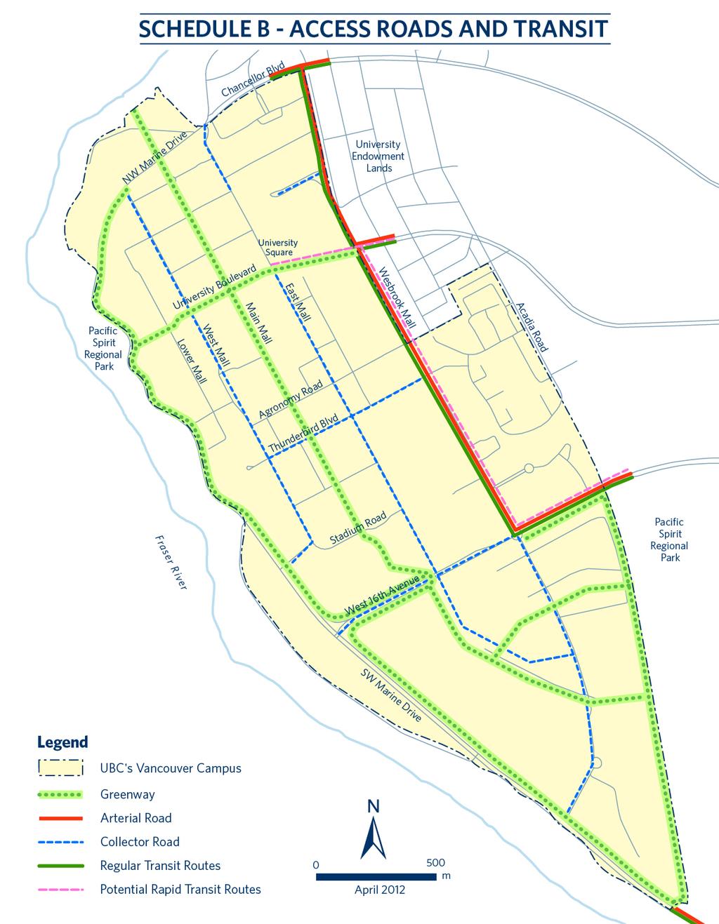
24 4.2 Access The university is the second largest destination in the Lower Mainland. Therefore, transportation is a major consideration in the UBC Land Use Plan, not only because of its potential impact on adjacent communities and Pacific Spirit Regional Park, but also because it must be addressed with land use. An access plan, complementary to land use, to meet regional and community goals. Ecology: Decision making will be transit supportive, pedestrian friendly, and bicycle receptive to minimize pollution. Linkages to regional corridors will be coordinated. A strong program of transportation demand management will be followed. Economy: UBC will be the destination of better, more effective transit service. Policies will be more auto-restrained. Transit will be supported by locating higher density development in proximity to transit service. Opportunity will be provided for people to study and work at home. Community: Transit systems will be planned in conjunction with land use to provide access throughout both the campus and the residential areas. The on-campus circulation system will be hierarchical and recognize the multiple use but will favour pedestrian, bicycles, and transit. Principles of traffic calming will be applied Accessing UBC: Regional objectives support the development of a complete community to better relate locations of home/work/study to reduce the overall need for movement to and from the UBC campus. Regional objectives also support alternatives which are auto-restrained and transit supportive. Managing access to the campus area will require inter-jurisdictional dialogue and cooperation. a) GVRD and UBC will need to support TransLink in initiatives to increase the accessibility of the campus by transit (new routes, express buses, transit priority measures, etc.) from elsewhere in the Lower Mainland. b) The GVRD and UBC will need to support the extension of higher capacity transit service to the campus and UBC will need to support redevelopment of the transit terminal to accommodate this service. c) Most transit service will focus on the transit terminal, but routes are to be planned to ensure convenient access across the campus. d) UBC will continue to schedule classes and activities, within its institutional constraints, to reduce the peak demands on transit. e) UBC will work with the University Endowment Lands Administration, the City of Vancouver, and the Ministry of Transportation and Infrastructure to ensure that its detailed route planning for bicycles and pedestrians is supportive and consistent with other routes being planned outside the Land Use Plan area. 19
25 4.2.2 Transportation Demand Management: UBC will need vigorous action to restrain single occupant vehicle use. This will require cooperation with TransLink and other transportation agencies. a) UBC will need to continue to develop, communicate and pursue a transportation demand management plan that will include increasing parking costs and measures to reduce single occupant vehicle travel from 1996 levels by 20%, continuing to reduce the amount of commuter parking, and adopting policies that favour higher occupancy vehicles (car/van pools). b) UBC will need to promote, through education, pricing and other systems, the use of alternatives other than the single occupant vehicle. c) UBC will need to advance opportunities for telecommuting where possible. d) UBC will address truck travel, in cooperation with the City of Vancouver. e) UBC will need to investigate and pursue a U Pass program as part of Transportation Demand Management On-Campus Access: The on-campus access system is intended to provide convenient movement throughout the Land Use Plan area in a manner that favours pedestrians, cyclists, and transit users rather than the private automobile. The access system will be compatible with and foster a pleasant residential environment linked to community destinations. indicates the system of arterial roads (the main access routes) and the collector roadways (to distribute traffic on campus). b) The access system will be such that rights-of-way are designed according to the function of the roadway. This will require redesign and redevelopment over time, including the downsizing and reorientation of some roadways and intersections to meet local functions. c) The roadway network will be designed to distribute traffic onto several arterials, rather than focusing it on one particular route. d) The access system is to be designed to be less auto-dominated, and is to be more favourable to the needs of pedestrians, cyclists and transit. e) Principles of traffic calming will be applied, both in the residential area and in the academic areas, to ensure the safety and attractiveness of the public realm for cyclists and pedestrians. f) The pedestrian and bicycle network is to be integrated with the greenway system. g) On-campus shuttle bus routes that provide convenient coverage to all parts of the campus are developed in conjunction with TransLink and adjusted from time to time. a) UBC, in conjunction with the Ministry of Transportation and Infrastructure where relevant, will need to implement a hierarchical road system on campus. The proposed roadway hierarchy is shown on Schedule B: Access. It 20
26 4.3 Servicing Comprehensive provision of social and community services is key to the success of a viable community. Provisions for physical infrastructure services are an important component of any Land Use Plan to ensure land use objectives can be met in an economically and environmentally suitable manner. The comprehensive provision of social and community services is the key to success of a viable community. It is a requirement that these services be available concurrent with demand. Ecology: UBC will develop a long term physical development and servicing strategy that works with and minimizes impact on the natural environment, especially Pacific Spirit Regional Park. Servicing plans will address issues of energy conservation. Economy: Development will be supported by appropriate levels of both hard and soft services required by the future diverse resident population. There will be recognition of UBC s role in the provision of services to the wider community. A staged and economically sustainable physical servicing strategy is essential. Local public services will be delivered and financed in a manner that is efficient, equitable and accountable in accordance with applicable legislation. Community: Servicing levels will be consistent with community needs and meet objectives in areas such as safety, mixed use, and access. UBC will need to maintain its role in providing regional amenities such as, recreational and cultural facilities. Expansion of protective services (fire, police, ambulance) will be staged to coincide with development Long Term Infrastructure & Servicing: UBC requires a long term strategy for maintaining, improving, and installing infrastructure and physical services for both existing and new development consistent with this Land Use Plan. This will include services such as sewer, water, solid waste, telephone, gas, steam, drainage, roadways, greenways, electricity, etc. a) UBC will need to prepare and implement a long term physical servicing strategy to ensure services are available for both existing and proposed development. b) This strategy will need to be innovative and economically sustainable, and reflect the creativity and high environmental standards expected of a leading university. This servicing strategy must work with and minimize impact on the natural environment both on and off-campus. c) Servicing plans will need to address issues of energy conservation and demand-side management for solid waste, water conservation and other services. d) As in other communities, development will pay its own way (including the costs of off-site facilities) and not impose costs on the external community. 21
27 e) UBC will develop a greenhouse gas reduction strategy for Neighbourhood Plan areas Social and Community Services: For a complete community, servicing levels for social and community services (institutional, recreation, parks, library, schools, etc.) need to be consistent with community needs and meet objectives in areas such as safety and access. a) UBC will need to maintain its role in managing its regional amenities such as recreational and cultural facilities. b) The provision of social and community services, such as library, neighbourhood parks, and recreation services, will be the responsibility of UBC (assuming the current local governance structure) either directly or on the basis of agreements with appropriate agencies. c) UBC will maintain a park and leisure services management plan to address the provision of community services Coordination: To ensure coordination and effective implementation of the UBC Land Use Plan for cross-boundary issues: a) UBC will need to participate in consultative processes with other agencies, interests, and jurisdictions b) UBC and GVRD will need to jointly address slope stability and erosion issues. Full consultation with the public on design, implementation, construction, and maintenance will be required. 22
28 5.1 Staging Institutional development has gone through a recent period of significant expansion. Student housing has reached the previously set 25% target (of full time, undergraduate students) and neighbourhood housing has continued at a steady rate in Neighbourhood Housing Areas. In 2009 there are approximately 16,500 people living on campus. There are approximately 18,000 jobs on the campus at UBC, support services, research facilities, the hospital and other locations in The implementation of this Land Use Plan is a long range proposition. Based on current expectations, development will continue for a period of thirty or more years. There are no precise definitions of exactly when specific developments will occur. This will depend on a series of factors such as market conditions. Further non-institutional development will depend on certain other activities preceding. For example, major housing development will require, as a prerequisite, completion of area plans and servicing strategies. Completion of the development in the southern village centre will require a substantial population to support it. This section of the Land Use Plan describes the general staging sequence. The general sequencing for development, assuming other conditions are met (such as the approval of a long term servicing strategy), can be defined in the general categories of short range, midterm, and long range Short Range: Development activities in this phase, on the order of up to 5 years, will be based on: a) those institutional developments in the UBC s capital planning process; b) the installation of servicing works needed to support the existing and planned uses; c) those activities which must be relocated or rationalized, such as bio-science uses, to allow other future land uses consistent with Schedule A: Land Use Plan; d) planning or provision of new transit facilities, such as high capacity transit, to UBC; e) those uses for which there appears to be an immediate demand, such as university centre commercial, redevelopment of the faculty club, or other activities such as research which can be initiated and expanded as the need is defined; f) area planning for housing on various sites which would infill the mid-campus or contribute to the residential development of the neighbourhood incorporating and surrounding the village centre, and the start of residential development Mid Range: Development activities in this phase, on the order of 5 to 10 years, will be based on: a) activities initiated in the short range phase, such new housing areas, will continue if not yet complete; 23
29 b) Planning for community social facilities is well advanced; c) emphasis for the location of new housing will be in proximity to already developed housing areas; d) transit service may be modified across the campus to serve the new uses Long Range: After about 10 years and up to possibly 35 years: a) the institutional uses continue to redevelop as needed; b) continuing development of the residential community south of West 16th Avenue will be the primary focus as it is generally staged from north to south in proximity to adjacent development, closer to services, and to allow for the efficient expansion of transit and pedestrian facilities; and Neighbourhood Distribution The UBC Board of Governors adopted residential floor space allocations for neighbourhoods on campus to ensure a future population that would support a sustainable community and to transfer the floor space that would have been accommodated on the UBC Farm and other areas to new neighbourhoods (see Land Use Plan Next Steps: Neighbourhood Distribution Report, April 2011 to Board of Governors). Achieving these floor space allocations is essential to UBC s academic mission, student housing goals, faculty and staff housing goals, endowment value and sustainable community goals. All residential floor space not achieved in these neighbourhoods will be located to different parts of campus in future. c) as population grows, the community facilities such as the remainder of the commercial village centre (which itself can be staged), the community centre, the greenway, and the school will be provided. At growth rates of about 175 new dwelling units per year (representing the history of development in Hampton Place), the population increased by about 4000 persons from 8700 in 1996 to 12,700 in This includes a student residence population of about Continued growth at a similar rate would result in a 2021 population of about 22,500 including approximately 10,000 students on academic lands. The amount of year-round population associated with student beds depends on the number of year-round contracts, which varies over time. 24
30 Definition of Terms The following definitions will be used for interpretation of the provisions of the UBC Land Use Plan: Non-market housing may include staff, faculty, cooperative, social and other special needs housing. For the purposes of this definition, non-market housing does not include housing specifically for students as contemplated in Section a). A fine grained development pattern is one that fosters public pedestrian linkages, through routes, short blocks, and the orientation of smaller scaled housing towards the street rather than an internal project orientation. Net area is that housing area within a local area plan, as shown in this OCP, which does not include public roadways and municipal service areas or public service uses such as day care centres, schools, community facilities, greenways and parks. For the purposes of density calculations, tree preservation areas and green edges on the property are included in the net area. Non-Institutional development means development other than that for the main academic mission of UBC (teaching, research, cultural expression, support facilities). Non-institutional development includes market housing, non-market housing other than student housing, and commercial developments generally intended for non-university users. 25
31
32
2.0 Regional Context Statement
 2.0 Regional Context Statement REGIONAL CONTEXT STATEMENT Part 10 of the Municipalities Enabling and Validating Act (No.3) (MEVA), requires UBC to include a Regional Context Statement in a Land Use Plan.
THE UNIVERSITY OF BRITISH COLUMBIA
 THE UNIVERSITY OF BRITISH COLUMBIA Report to the Board of Governors Agenda Item # 3.3 SUBJECT REGIONAL CONTEXT STATEMENT MEETING DATE June 4, 2013 APPROVED FOR SUBMISSION Forwarded to the Board of Governors
REPORT TO THE BOARD OF GOVERNORS
 Agenda Item #6.6 REPORT TO THE BOARD OF GOVERNORS SUBJECT AMENDMENT REGIONAL CONTEXT STATEMENT LAND USE PLAN (VANCOUVER) MEETING DATE November 26, 2013 Forwarded to the Board of Governors on the Recommendation
CONTENTS 8.0 LAND USE 8.1 GENERAL LAND USE 8.2 RESIDENTIAL 8.3 MIXED USE 8.4 COMMERCIAL 8.5 EMPLOYMENT LANDS
 8-2 Land Use 8.0 LAND USE CONTENTS 8.1 GENERAL LAND USE 8.1.1 Uses provided for in all Land Use Designations 8.1.2 Uses prohibited in Hazardous Lands, Hazardous Sites and Special Policy Areas 8.1.3 Uses
ELMVALE ACRES SHOPPING CENTRE MASTER PLAN
 ELMVALE ACRES SHOPPING CENTRE MASTER PLAN Contents 1.0 INTRODUCTION... 2 2.0 LOCATION... 2 3.0 EXISTING CONTEXT... 2 4.0 VISION & GUIDING PRINCIPLES... 2 5.0 LAND USE AND BUILT FORM... 4 5.1 St. Laurent
Mark-up of the effect of the proposed Bronte Village Growth Area OPA No.18 on the text of section 24, Bronte Village, of the Livable Oakville Plan
 Mark-up of the effect of the proposed Bronte Village Growth Area OPA No.18 on the text of section 24, Bronte Village, of the Livable Oakville Plan Notes: This document is provided for information purposes
and services The protection and conservation of environmentally significant and sensitive natural heritage features and functions.
 6. Land Use 6.0 Preamble A healthy and livable city is one in which people can enjoy a vibrant economy and a sustainable healthy environment in safe, caring and diverse neighbourhoods. In order to ensure
Urban Design Manual PLANNING AROUND RAPID TRANSIT STATIONS (PARTS) Introduction. Station Study Areas
 Introduction. Station Study Areas") 111111 PLANNING AROUND RAPID TRANSIT STATIONS (PARTS) Introduction The ION rapid transit system will link Waterloo, Kitchener and Cambridge through a central transit corridor (CTC). There are a number
111111 PLANNING AROUND RAPID TRANSIT STATIONS (PARTS) Introduction The ION rapid transit system will link Waterloo, Kitchener and Cambridge through a central transit corridor (CTC). There are a number
CITY OF LANGLEY OFFICIAL COMMUNITY PLAN BYLAW, 2005, NO APPENDIX II - REGIONAL CONTEXT MAP
 CITY OF LANGLEY OFFICIAL COMMUNITY PLAN BYLAW, 2005, NO. 2600 APPENDIX II - REGIONAL CONTEXT MAP ± Legend Agricultural Mixed Employment Industrial Conservation & Recreation Regional City Centre Urban Containment
13 THORNHILL YONGE STREET STUDY IMPLEMENTATION CITY OF VAUGHAN OPA 669 AND TOWN OF MARKHAM OPA 154
 13 THORNHILL YONGE STREET STUDY IMPLEMENTATION CITY OF VAUGHAN OPA 669 AND TOWN OF MARKHAM OPA 154 The Planning and Economic Development Committee recommends the adoption of the recommendations contained
[PLANNING RATIONALE] For Site Plan Control and Lifting of Holding Zone By-Law 101 Champagne Avenue. May 23, 2014
![[PLANNING RATIONALE] For Site Plan Control and Lifting of Holding Zone By-Law 101 Champagne Avenue. May 23, 2014](/thumbs/75/71599615.jpg "[PLANNING RATIONALE] For Site Plan Control and Lifting of Holding Zone By-Law 101 Champagne Avenue. May 23, 2014") [PLANNING RATIONALE] For Site Plan Control and Lifting of Holding Zone By-Law 101 Champagne Avenue May 23, 2014 Contents 1.0 Introduction... 2 2.0 Site Context... 2 2.1 Adjacent Uses... 2 Figure 1: Site
[PLANNING RATIONALE] For Site Plan Control and Lifting of Holding Zone By-Law 101 Champagne Avenue May 23, 2014 Contents 1.0 Introduction... 2 2.0 Site Context... 2 2.1 Adjacent Uses... 2 Figure 1: Site
Welcome to the Oakridge Centre Open House
 Welcome to the Oakridge Centre Open House Why is the City hosting this event? This open house is to inform you of a rezoning application submitted to the City of Vancouver to amend the existing CD-1 (Comprehensive
YONGE STEELES CORRIDOR SECONDARY PLAN. Young + Wright / IBI Group Architects Dillon Consulting Ltd. GHK International (Canada) Ltd.
 Ltd.") PART A: PREAMBLE 1.0 PURPOSE The purpose of this Secondary Plan is to provide a development framework for intensification of the Yonge/ Steeles corridor including the north side of Steeles Avenue West
PART A: PREAMBLE 1.0 PURPOSE The purpose of this Secondary Plan is to provide a development framework for intensification of the Yonge/ Steeles corridor including the north side of Steeles Avenue West
38 Queen s University Campus Master Plan Part 1
 38 Queen s University Campus Master Plan Part 1 46 The Campus at the City Scale Chapter 4 The Campus at the City Scale 39 Queen s is an urban University centrally located in Kingston. Decisions made by
URBAN DESIGN BRIEF URBAN DESIGN BRIEF 721 FRANKLIN BLVD, CAMBRIDGE August 2018
 URBAN DESIGN BRIEF URBAN DESIGN BRIEF 721 FRANKLIN BLVD, CAMBRIDGE August 2018 DESIGN BRIEF CONTENTS PART A 1.0 INTRODUCTION 2.0 DESCRIPTION & ANALYSIS OF SITE CONTEXT 3.0 DESIGN CONSTRAINTS AND OPPORTUNITIES
Town Center (part of the Comprehensive Plan)
") Town Center (part of the Comprehensive Plan) Mercer Island Town Center Looking North (2014) In 1994, a year-long process culminated in a set of design guidelines and code requirements for the Town Center
Town Center (part of the Comprehensive Plan) Mercer Island Town Center Looking North (2014) In 1994, a year-long process culminated in a set of design guidelines and code requirements for the Town Center
SECTION ONE: INTRODUCTION. introduction
 introduction 1 INTRODUCTION Since it was first established in 1843 as a trading post for the Hudson s Bay Company, Victoria has evolved into a Provincial capital city that is recognized across Canada and
Concord Community Reuse Project Goals and Guiding Principles. Overarching Goals (OG)
") Concord Community Reuse Project Goals and Guiding Principles Overarching Goals (OG) No priority is implied by the order of presentation of the goals and guiding principles. Overarching goals for the Concord
Concord Community Reuse Project Goals and Guiding Principles Overarching Goals (OG) No priority is implied by the order of presentation of the goals and guiding principles. Overarching goals for the Concord
FORMER CANADIAN FORCES BASE (CFB) ROCKCLIFFE SECONDARY PLAN. Official Plan Amendment XX to the Official Plan for the City of Ottawa
 ROCKCLIFFE SECONDARY PLAN. Official Plan Amendment XX to the Official Plan for the City of Ottawa") FORMER CANADIAN FORCES BASE (CFB) ROCKCLIFFE SECONDARY PLAN Official Plan Amendment XX to the Official Plan for the City of Ottawa 1 INDEX THE STATEMENT OF COMPONENTS PART A THE PREAMBLE PAGE Purpose...
FORMER CANADIAN FORCES BASE (CFB) ROCKCLIFFE SECONDARY PLAN Official Plan Amendment XX to the Official Plan for the City of Ottawa 1 INDEX THE STATEMENT OF COMPONENTS PART A THE PREAMBLE PAGE Purpose...
6 Growth Management Challenges and Opportunities
 6 Growth Management Challenges and Opportunities The Town has established a goal of attaining a 50% participation rate with respect to employment opportunities versus residential population. The Town s
178 Carruthers Properties Inc.
 178 Carruthers Properties Inc. Planning Rationale for 178 Carruthers Avenue Site Plan Control Application June 2014 Table of Contents 1.0 Introduction 2.0 Overview of Subject Property 3.0 Current Zoning
4 Sustainability and Growth Management
 4 Sustainability and Growth Management Introduction Traditionally, has assumed growth and development with limited consideration for the long-term negative social, environmental or economic impacts on
2.0 A FRAMEWORK FOR SUSTAINABLE GROWTH CONTENTS
 2-2 A Framework for Sustainable Growth 2.0 A FRAMEWORK FOR SUSTAINABLE GROWTH CONTENTS 2.1 MANAGING SUSTAINABLE GROWTH THE VISION TO 2031 2.2 GOALS AND OBJECTIVES 2.2.1 Protecting the Natural Environment
6. REGIONAL AND COMMUNITY FACILITIES DESIGNATIONS 6.1. OBJECTIVES FOR REGIONAL AND COMMUNITY FACILITIES LAND USE DESIGNATIONS
 6. REGIONAL AND COMMUNITY FACILITIES DESIGNATIONS INTRODUCTION The Regional and land use designations provide the primary locations for uses which satisfy the health, education and other service needs
Official Plan Review: Draft Built Form Policies
 PG.30.1 REPORT FOR ACTION Official Plan Review: Draft Built Form Policies Date: May 15, 2018 To: Planning and Growth Management Committee From: Chief Planner and Executive Director, City Planning Division
A Growing Community Rural Settlement Areas
 Town of Huntsville Official Plan Review - POLICY BACKGROUND PAPER A Growing Community Rural Settlement Areas BACKGROUND: In addition to the fully municipally-serviced Urban Settlement Area and the Hidden
Goal 1: To Encourage the Orderly, Harmonious and Judicious Use of University Resources in the Development of University Land.
 2.0 Future Land Use Goal 1: To Encourage the Orderly, Harmonious and Judicious Use of University Resources in the Development of University Land. Objective 1.1: Make available future building sites that
Trafalgar Road Corridor Planning Study Open House
 Trafalgar Road Corridor Planning Study Open House June 24, 2013 6:30-8:30 p.m. Oakville & Trafalgar Rooms Overview The Livable Oakville Plan identifies the lands along Trafalgar Road, between the QEW and
Official Plan Review
 Official Plan Review Summary Report - The Built Environment August 2014 Part 1: Introduction Planning for a healthy, prosperous and sustainable community is an important goal for our municipality. From
PORT WHITBY COMMUNITY
 PORT WHITBY COMMUNITY SECONDARY PLAN UPDATE COMMUNITY IMPROVEMENT PLAN URBAN DESIGN GUIDELINES September 2015 DRAFT PROPOSED AMENDMENT NUMBER # to the Whitby Official Plan PURPOSE: The intent of this Amendment
Welcome! UBC Community Conversations. Proposed new community garden space in Chancellor Place and Wesbrook Place. Traffic flow on Iona Drive
 1 Welcome! UBC Community Conversations Thank you for joining us this evening, please take a feedback form, help yourself to some food and have a look around! We have information available on: Proposed
implementation r expression in landscape
 6 ubc okanagan implementation campus plan r expression in landscape 68 6 implementation campus plan sections The Campus Plan supports the academic mission, values and commitments of the University by providing
Complete Neighbourhood Guidelines Review Tool
 Complete Neighbourhood Guidelines Review Tool Prepared By: City of Regina Planning Department October 2014 Page 1 of 14 Community Development Review Checklist for Secondary Plans and Concept Plans The
Municipal Development Plan Update Urban Service Area and Hamlets
 ENCLOSURE 1 Municipal Development Plan Update Urban Service Area and Hamlets Priorities Committee January 24, 2017 MUNICIPAL DEVELOPMENT PLAN UPDATE SHAPING OUR FUTURE MDP Update - Agenda MDP Update Public
5 TOWN OF MARKHAM OFFICIAL PLAN AMENDMENT NO. 144 MILLIKEN MAIN STREET SECONDARY PLAN
 5 TOWN OF MARKHAM OFFICIAL PLAN AMENDMENT NO. 144 MILLIKEN MAIN STREET SECONDARY PLAN The Planning and Economic Development Committee recommends the following: 1. The communication from Brendan O Callaghan,
Wesbrook Place Neighbourhood Plan. University of British Columbia
 Wesbrook Place Neighbourhood Plan University of British Columbia January 24, 2005 Adopted December 2005 Amended December 2011 Amended April 2016 Table of Contents 1.0 INTRODUCTION 1.1 Overview 1.2 The
SECTION E. Realizing the Plan
 SECTION E Realizing the Plan 60 DESIGN REGINA - OFFICIAL COMMUNITY PLAN SECTION E Realizing the Plan Design Regina has been an ambitious plan-making exercise, with a high level of community, stakeholder,
URBAN DESIGN BRIEF. 2136&2148 Trafalgar Road. Town of Oakville
 URBAN DESIGN BRIEF 2136&2148 Trafalgar Road Town of Oakville Prepared By: METROPOLITAN CONSULTING INC For 2500674 Ontario Inc November 2016 TABLE OF CONTENTS Page No. 1.0 Introduction/Description of Subject
PSRC REVIEW REPORT & CERTIFICATION RECOMMENDATION
 PSRC REVIEW REPORT & CERTIFICATION RECOMMENDATION KITSAP COUNTY COUNTYWIDE PLANNING POLICIES July 2, 2012 BACKGROUND A major emphasis of the Washington State Growth Management Act (GMA) is the need to
Cambie Corridor Planning Program Phase Two Draft Plan. Standing Committee on City Services and Budgets May 5, 2011
 Cambie Corridor Planning Program Phase Two Draft Plan Standing Committee on City Services and Budgets May 5, 2011 Cambie Corridor Program Terms of Reference approved July 2009 Land Use Transportation Energy
KANATA CENTRUM 255 KANATA AVENUE OFFICIAL PLAN AMENDMENT ZONING BY-LAW AMENDMENT
 KANATA CENTRUM 255 KANATA AVENUE OFFICIAL PLAN AMENDMENT ZONING BY-LAW AMENDMENT JUNE 2015 PREPARED BY: FOTENN Consultants Inc. 223 Mcleod Street Ottawa, ON K2P OZ8 (613) 730-5709 PREPARED FOR: Kanata
Silverdale Regional Center
 Silverdale Regional Center Vision for Silverdale Regional Center The Silverdale Regional Center Plan (Plan) will guide the evolution of the Silverdale Regional Center from a collection of strip malls and
Create Policy Options Draft Plan Plan Approval. Public Consultation Events. Phase 2
 Background Grandview-Woodland Community Plan In the spring of 2012, the City of Vancouver embarked on a comprehensive community planning program in the Grandview-Woodland neighbourhood. The process has
Technical Appendix L, University Community Plan Town Center
 Technical Appendix L, University Community Plan Town Center Table of Contents L.1 Executive Summary L.2 Merced County University Community Plan, 2004 Findings L.2.1 Visioning L.2.2 UCP Goals, Objectives
CONTENTS 2.0 A FRAMEWORK FOR SUSTAINABLE GROWTH 2.1 MANAGING SUSTAINABLE GROWTH THE VISION TO GOALS AND OBJECTIVES 2.3 MARKHAM STRUCTURE
 2 A Framework for Sustainable Growth 2.0 A FRAMEWORK FOR SUSTAINABLE GROWTH CONTENTS 2.1 MANAGING SUSTAINABLE GROWTH THE VISION TO 2031 2.2 GOALS AND OBJECTIVES 2.2.1 Protecting the Natural Environment
The West Vaughan Employment Area Secondary Plan Policies
 Part 2: The West Vaughan Employment Area Secondary Plan Policies 2.1 General Policies It is the policy of Council: 2.1.1. That the West Vaughan Employment Area (the WVEA), identified on Schedule 1, will
K. SMART ASSOCIATES LIMITED
 Planning Justification Report Zoning By-Law Amendment 185 King Street North Waterloo, Ontario April 7th, 2017 Project Reference Number 16-245 K. SMART ASSOCIATES LIMITED CONSULTING ENGINEERS AND PLANNERS
DAVENPORT VILLAGE SECONDARY PLAN
 27 DAVENPORT VILLAGE SECONDARY PLAN 27. DAVENPORT VILLAGE SECONDARY PLAN 1. VISION FOR THE DAVENPORT VILLAGE SECONDARY PLAN Davenport Village, municipally known as 830, 940, 980 and 1100 Lansdowne Avenue,
EXISTING COMPREHENSIVE PLAN
 EXISTING COMPREHENSIVE PLAN Town Center Land Use Element: V. LAND USE POLICIES Town Center Mercer Island's business district vision as described in "Your Mercer Island Citizen-Designed Downtown" was an
The Cambie Corridor 2015 Fall workshop series. What we heard WORKSHOP OUTLINE
 The Cambie Corridor 2015 Fall workshop series W 16 AVE Area 5 CAMBIE CORRIDOR Phase 3 What we heard ovember 21, 2015, 9am-noon, 1:30-4:30pm Peretz Centre 89 Participants* WORKSHOP OUTLIE Introductions
The Five Components of the McLoughlin Area Plan
 The Five Components of the McLoughlin Area Plan This documents contains the complete language of the five components of the McLoughlin Area Plan: The Vision Statement The Values The Guiding Principles
City of Vancouver Regional Context Statement Official Development Plan. (Adopted by By-law No , September 24, 2013)
") City of Vancouver Regional Context Statement Official Development Plan (Adopted by By-law No. 10789, September 24, 2013) Table of Contents Introduction GOAL 1 Create a Compact Urban Area STRATEGY 1.1
City of Vancouver Regional Context Statement Official Development Plan (Adopted by By-law No. 10789, September 24, 2013) Table of Contents Introduction GOAL 1 Create a Compact Urban Area STRATEGY 1.1
C. Westerly Creek Village & The Montview Corridor
 C. Westerly Creek Village & The VISION Community Vision When the goals of the city are achieved Westerly Creek Village, a distinctive community defined by Montview Boulevard and Westerly Creek, is a strong
*** DRAFT 2 FOR PUBLIC REVIEW ***
 6.7 The area is generally bounded by the Red Hill Valley Parkway to the west, Lake Avenue to the east, the Queen Elizabeth Way (QEW) to the north, and by the properties just south of Queenston Road to
3 TOWN OF WHITCHURCH-STOUFFVILLE OFFICIAL PLAN AMENDMENT NOS. 116 & 117
 3 TOWN OF WHITCHURCH-STOUFFVILLE OFFICIAL PLAN AMENDMENT NOS. 116 & 117 The Planning and Economic Development Committee recommends the adoption of the recommendations contained in the following report,
Community Design Guidelines. Port Wallace DRAFT
 Community Design Guidelines Port Wallace DRAFT Energy 1 2 3 Nature Movement Connections Built Form DRAFT Layout Energy 1 Nature Community Design Guidelines GREAT COMMUNITIES PROTECT, CELEBRATE, AND CONSERVE
Clairtrell Area Context Plan
 Clairtrell Area Context Plan March 2005 Urban Development Services City Planning Contents 1. Introduction... 4 2. Development Structure... 6 2.1 Streets... 7 2.1.1 Sheppard Avenue and Bayview Avenue...
3.1 Existing Land Use
 3.0 Land Use This strategy has been developed taking into account the position of the Town of Sidney as the economic center of the Saanich Peninsula. It acknowledges existing land use patterns in the downtown
Phase 1 : Understanding the Campus Context. Phase 2 : APPROACHES - Alternates & Preferred Plan
 Introduction MASTER PLAN PURPOSE WHY A CAMPUS MASTER PLAN? The purpose of the Master Plan at the University of Illinois at Chicago is to translate UIC s strategic goals and objectives into a compelling
Colchester Northern Gateway Master Plan Vision Review Draft. July 2016
 Colchester Northern Gateway Master Plan Vision Review Draft July 2016 Contents Introduction 4 Context 8 Purpose of the Report 8 Strategic Position 9 Overview of the Process 11 2012 Master Plan Vision 12
Chapter 1. Community Context. Vision Statement Population and Housing Trends Legislative Context Regional Context Statement
 Chapter 1 Community Context Vision Statement Population and Housing Trends Legislative Context Regional Context Statement 1.1 VISION STATEMENT CORPORATE MISSION STATEMENT To promote a safe and livable
Draft Urban Hamilton Official Plan. Amendment No. XX
 1 of 75 The following text, together with: Draft Appendix A Appendix B Volume 1, Schedule E-1 Urban Land Use Designations Appendix C Volume 1, Appendix A Parks Classification Map Appendix D Volume 1, Appendix
CDAC. Update: Downtown Dartmouth Update: CDAC July 25 th Motion
 CDAC Update: Downtown Dartmouth Update: CDAC July 25 th Motion 2018-10-24 Downtown Dartmouth Plan Open House October 22, 2018 6:00 pm Open House 6:30 pm Presentation + Q&A 7:20 pm Open House 8:30 pm Close
141 GEORGE STREET PLANNING RATIONALE
 141 GEORGE STREET PLANNING RATIONALE MINOR ZONING BY-LAW AMENDMENT NOVEMBER 2, 2016 PLANNING RATIONALE 223 McLeod Street Ottawa, ON K2P 0Z8 613.730.5709 fotenn.com INTRODUCTION FOTENN Consultants is acting
Economy Vision Statements: Social Wellbeing Vision Statements: Natural Environment Vision Statements:
 Economy Vision Statements: 1. Our business environment makes us a region of choice for new employers as we encourage entrepreneurship and have a vibrant, diversified and resilient regional economy. 2.
DAREBIN PLANNING SCHEME AMENDMENT C137
 Who is the planning authority? Planning and Environment Act 1987 DAREBIN PLANNING SCHEME AMENDMENT C137 EXPLANATORY REPORT This amendment has been prepared by the Darebin City Council, who is the planning
1.3 TRANSIT VISION 2040 FROM VISION TO ACTION THEME 1: PUTTING TRANSIT AT THE CENTRE OF COMMUNITIES. Fully integrate transit with community planning
 TRANSIT VISION 2040 FROM VISION TO ACTION TRANSIT VISION 2040 defines a future in which public transit maximizes its contribution to quality of life with benefits that support a vibrant and equitable society,
LAND USE OVERVIEW WHAT YOU WILL FIND IN THIS CHAPTER
 LAND USE WHAT YOU WILL FIND IN THIS CHAPTER Information about the City s expected population and employment growth. Description and capacity of existing and future land use designations. Policies that
2040 LUP is a part of the Comprehensive Plan and carries the same legal authority. Economic Challenges
 1.1. Guiding Anchorage s Growth Where will new residents settle over the next two decades? Where will people work, shop, and play? Will there be enough room to grow? How will Anchorage look? Will growth
UNIVERSITY TOWN NEIGHBOURHOODS 5.5 HOUSING MELBOURNE CAMPUS MASTER PLAN 2014
 5.5 169 EXISTING CONDITIONS & VISION NEIGHBOURHOOD VISION The provision of on-campus housing into the future will continue to be an important element of the La Trobe University experience. A long-term
Foreword to the Third + Edition
 U n i v e r s i t y of Oregon Campus Plan - Third + Edition, 2017 i Foreword to the Third + Edition Third + Edition (November 2017) This third + edition of the 2005 Campus Plan integrates amendments approved
Figure 3-1: Public Realm Plan
 3 Public Realm Figure 3-1: Public Realm Plan 3.1 Public Realm Concept The public realm concept for the Little Mountain site integrates a clear and accessible movement network with public spaces for social
Plano Tomorrow Vision and Policies
 Plano Tomorrow Vision and Policies PLANO TOMORROW PILLARS The Built Environment The Social Environment The Natural Environment The Economic Environment Land Use and Urban Design Transportation Housing
3. Endorse the LRT vision in transforming Surrey into Connected-Complete-Livable communities, and more specifically, the official vision statement:
 CORPORATE REPORT NO: R038 COUNCIL DATE: February 20, 2017 REGULAR COUNCIL TO: Mayor & Council DATE: February 16, 2017 FROM: General Manager, Engineering FILE: 8740-01 SUBJECT: Surrey Light Rail Transit
Urban Planning and Land Use
 Urban Planning and Land Use 701 North 7 th Street, Room 423 Phone: (913) 573-5750 Kansas City, Kansas 66101 Fax: (913) 573-5796 Email: planninginfo@wycokck.org www.wycokck.org/planning To: From: City Planning
QUEEN-RIVER SECONDARY PLAN
 34 QUEEN-RIVER SECONDARY PLAN 34. QUEEN RIVER SECONDARY PLAN 1. INTRODUCTION The Queen-River area is approximately 6.4 hectares and is located at the eastern edge of the Downtown as shown on Map 34-1.
URBAN DESIGN BRIEF Gordon Street City of Guelph. Prepared on behalf of Ontario Inc. March 25, Project No. 1507
 URBAN DESIGN BRIEF 1131 Gordon Street City of Guelph Prepared on behalf of 1876698 Ontario Inc. March 25, 2016 Project No. 1507 423 Woolwich Street, Suite 201, Guelph, Ontario, N1H 3X3 Phone (519) 836-7526
Regional Context Statement
 Regional Context Statement REGIONAL CONTEXT STATEMENT 3. REGIONAL CONTEXT STATEMENT In 1995, the Provincial Government passed into law the Growth Strategies Act. The purpose of this provincial initiative
1 Welcome! UBC Okanagan Master Plan Update - Open House
 1 Welcome! UBC Okanagan Master Plan Update - Open House UBC is updating the Master Plan for the Okanagan Campus. The purpose of today s Open House is to: Present the draft 2015 Master Plan Answer any questions
Queensborough Eastern Neighbourhood Node. Community Open House
 Queensborough Eastern Community Open House The Vision The Queensborough Eastern will become the heart of eastern Queensborough. Through a sensitive mix of viable commercial and residential areas, the neighbourhood
DRAFT Land Use Chapter
 Stevens Creek Urban Village DRAFT 1 18 17 Land Use Chapter INTRODUCTION This Land Use Chapter describes how the Stevens Creek Urban Village will accommodate the growth that is planned for it in the Envision
In surveys, Dallas residents say what they want to change most
 NEIGHBORHOODS ELEMENT In surveys, Dallas residents say what they want to change most in the city is its appearance they want it to look beautiful, with trees and pedestrian-friendly neighborhoods. The
CITY CLERK. Parkland Acquisition Strategic Directions Report (All Wards)
") CITY CLERK Clause embodied in Report No. 10 of the, as adopted by the Council of the City of Toronto at its meeting held on November 6, 7 and 8, 2001. 10 Parkland Acquisition Strategic Directions Report
CITY CLERK Clause embodied in Report No. 10 of the, as adopted by the Council of the City of Toronto at its meeting held on November 6, 7 and 8, 2001. 10 Parkland Acquisition Strategic Directions Report
Municipal Development Plan 2013
 UNIQUELY STONY PLAIN: Municipal Development Plan 2013 Quick Reference Guide What is a Municipal Development Plan (MDP)? The Town s highest-level planning document Sets the long-term vision and key themes
Westwind Developments Ltd. PIONEER LANDS AREA STRUCTURE PLAN - PROPOSED AMENDMENT
 FEBRUARY 2013 TABLE OF CONTENTS 1.0 BACKGROUND... 1 1.1 Amendment... 1 2.0 LOCATION & CONTEXT... 2 2.1 Land Ownership... 2 3.0 POLICY CONTEXT... 3 3.1 Municipal Development Plan... 3 3.2 Capital Region
iii. Visioning framework
 III. VISION iii. Visioning framework III.1 Overview A vision is a clear and succinct description of what an institution and its community should look like after it successfully implements its goals and
WELCOME and introduction
 1 WELCOME and introduction Mobility Hub Locations within Burlington STUDY OVERVIEW STUDY OBJECTIVES The City of Burlington is developing four Area Specific Plans, one for each of Burlington s Mobility
CAL POLY MASTER PLAN UPDATE, March 2015
 Some Key Themes in the General Guiding Principles Academic Mission The plan must foremost advance the University s academic mission and student success. Foresight and Adaptability The plan should take
Welcome. Walk Around. Talk to Us. Write Down Your Comments
 Welcome This is an information meeting introducing the applications for proposed redevelopment of the Yorkdale Shopping Centre site at 3401 Dufferin Street and 1 Yorkdale Road over the next 20+ years,
THE CITY OF VAUGHAN BY-LAW BY-LAW NUMBER A By-law to adopt Amendment Number 1 to the Official Plan of the Vaughan Planning Area.
 THE CITY OF VAUGHAN BY-LAW BY-LAW NUMBER 015-2014 A By-law to adopt Amendment Number 1 to the Official Plan of the Vaughan Planning Area. NOW THEREFORE the Council of the Corporation of the City of Vaughan
9.5 Austin Heights Neighbourhood Plan
 City of Coquitlam Austin Heights Neighbourhood Plan 1.0 BACKGROUND 1 1.1 Welcoming Innovative and Sustainable Investment in Neighbourhoods 1 1.2 Relationship with the CWOCP and the SWCAP 1 1.3 Austin Heights
SCHEDULE 'A' TO BY-LAW as Amended by AMENDMENT NO. 90 TO THE WHITBY OFFICIAL PLAN
 SCHEDULE 'A' TO BY-LAW 6413-10 as Amended by 6553-11 AMENDMENT NO. 90 TO THE WHITBY OFFICIAL PLAN SECTION A: GROWTH PLAN CONFORMITY PURPOSE: LOCATION: BASIS: The purpose of this Amendment is to: conform
10.0 Open Space and Public Realm
 10.0 Open Space and Public Realm 10.0 Open Space and Public Realm The Public Open Space System is comprised of: outdoor spaces available for public use that are either publicly owned (e.g., parks and
The lands identified as Residential Areas on Schedule A1, Urban Structure, represent the areas that provide for stable residential communities.
 Livable Oakville Part D: Land Use Designations and Policies 11. RESIDENTIAL 11.1 General The lands identified as Residential Areas on Schedule A1, Urban Structure, represent the areas that provide for
OFFICE CONSOLIDATION SECONDARY PLAN AREA 22 THE BRAMALEA SOUTH INDUSTRIAL SECONDARY PLAN
 OFFICE CONSOLIDATION SECONDARY PLAN AREA 22 THE BRAMALEA SOUTH INDUSTRIAL SECONDARY PLAN November 2010 EXPLANATORY NOTES (Secondary Plan Area 22) General (pertaining to all secondary plan office consolidations)
Former Rockcliffe Airbase Community Design Plan Guiding Design Vision and Principles December 4, 2013
 APPENDIX 5 - Guiding Design Vision and Principles Former Rockcliffe Airbase Community Design Plan Guiding Design Vision and Principles December 4, 2013 Vision Statement The redevelopment of the former
CONTENTS 6.1 URBAN DESIGN
 6-2 Urban Design and Sustainable Development 6.0 URBAN DESIGN AND SUSTAINABLE DEVELOPMENT CONTENTS 6.1 URBAN DESIGN 6.1.1 General Policies 6.1.2 The Public Realm 6.1.3 Streets and Blocks 6.1.4 Streetscapes
5.1 Site Plan Guidelines
 5. Community Core Guidelines Development of the Community Core will take place by plan of subdivision and site plan approval. It will occur in a phased manner that will reflect the timing of residential
Gold Line Bus Rapid Transit Transit Oriented Development (BRTOD) Helmo Station Area Plan
 Helmo Station Area Plan") Appendix F Gold Line Bus Rapid Transit Transit Oriented Development (BRTOD) Helmo Station Area Plan Introduction and Purpose of the Plan The Gold Line Bus Rapid Transit facility is an eleven-mile dedicated
Appendix F Gold Line Bus Rapid Transit Transit Oriented Development (BRTOD) Helmo Station Area Plan Introduction and Purpose of the Plan The Gold Line Bus Rapid Transit facility is an eleven-mile dedicated
4.1.3 LAND USE CATEGORIES
 4.1.3 LAND USE CATEGORIES a. City Center District The City Center District incorporates the existing character and mix of uses in downtown Belmont to encourage redevelopment and new development in keeping