Funding Application. Project Information. Contact Information. Project Description. 1 of 10. September 20th, :46 PM
|
|
|
- Patrick Carpenter
- 6 years ago
- Views:
Transcription

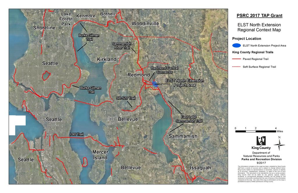
1 1 of 10 Funding Application Competition Application Type Status Submitted: Regional TAP Bicycle and Pedestrian submitted September 20th, :46 PM Project Information 1. Project Title East Lake Sammamish Trail North Extension 2. Transportation 2040 ID Sponsoring Agency King County Parks Department 4. Cosponsors City of Redmond 5. Does the sponsoring agency have "Certification Acceptance" status from WSDOT? Yes 6. If not, which agency will serve as your CA sponsor? N/A Contact Information 1. Contact name David Morrison 2. Contact phone (206) Contact Project Description 1. Project Scope This project will complete the East Lake Sammamish Trail in the former BNSF Rail Corridor through the SR 520/SR 202 Interchange and over Bear Creek, linking the northern terminus of the East Lake Sammamish Trail with the southern terminus of the Redmond Central Connector in Redmond. The trail will be approximately 1,750 feet long and contain a 12-footwide paved trail with 2 foot-wide gravel shoulders and a 1 foot-wide clear zone on both sides, consistent with King County Parks Regional Trails Standards and the FHWA Small Town and Rural Multimodal Networks Guidebook. To cross Bear Creek, the trail will use an ADA accessible bridge over the entire 100 year Bear Creek floodplain. This project will also remove the existing rail bridge over Bear Creek which includes structure within the creek that is causing a constriction and reducing stream health on the Lake Washington Basin s most productive salmon bearing stream. The trail will pass through the SR 520/SR 202 Interchange at existing rail grade with two new undercrossing at the westbound SR 520 on-ramp and eastbound SR 520 off-ramp. This is only possible because Sound Transit will be rebuilding the on- and off-ramps to
2 only possible because Sound Transit will be rebuilding the on- and off-ramps to 2 of 10 accommodate the light rail guideway for the Downtown Redmond Link Extension(DRLE) (to be completed by 2024) creating a once in a lifetime opportunity for the trail to be built through the SR 520/SR 202 Interchange. 2. Project Justification, Need, or Purpose This trail project is a once-in-a-lifetime opportunity to complete a critical missing link in the King County Regional Trails Network that is separated by a significant barrier that exists today, SR 520. Construction of this missing link will eliminate the key barrier that exists today caused by SR 520. This trail extension project will serve as the primary connection for bicycles and pedestrians between Downtown Redmond and SE Redmond. The barrier caused by SR 520 make travel between these two areas difficult and stressful for nonmotorized users including people with disabilities, due to its circuitous nature, three separate road crossings, two of which require users to cross six lanes of traffic on SR 202, and the high volume of traffic (35,466 average weekday daily traffic) on SR 202. Timing is critical, this connection can only be completed if it is incorporated into the Sound Transit DRLE project design build contracting process which begins in early This project has been a top priority for both King County and City of Redmond for decades but could not be completed due to the need to rebuild the SR 520 on- and off-ramps at SR 202 fortunately the DRLE design/build contract process provides that opportunity. This project will play an important role in the regional multimodal transportation system by significantly improving access to light rail, regional buses, and local buses, as well as significantly expanding the regional trail bike shed and walkshed to a high number of jobs and homes. When these two regional trails are linked they will will provide connections to 15,450 residents and 16,640 employees in the Marymoor Local Center (2030) and in Downtown Redmond (2030), nearly all within a mile of the project. Project Location 1. Project Location The project is located in the City of Redmond near the SR 520/SR 202 Interchange. The project extends from the southern terminus of the Redmond Central Connector Trail at its intersection with the Bear Creek Trail to the northern terminus of the East Lake Sammamish Trail at NE 70th St. 2. Please identify the county(ies) in which the project is located. King 3. Crossroad/landmark nearest the beginning of the project Redmond Central Connector and Bear Creek Trail intersection. (Redmond) 4. Crossroad/landmark nearest the end of the project East Lake Sammamish Trail and NE 70th St. intersection (Redmond) 5. Map and project graphics ELST_North_Extension_-_Project_Area_Map.pdf, ELST_North_Extension_- _Regional_Context_Map.pdf, ELST_North_Extension_-_Plan_Profile.pdf Plan Consistency 1. Is the project specifically identified in a local comprehensive plan? Yes 2. If yes, please indicate the (1) plan name, (2) relevant section(s), and (3) page number where it can be found. a) King County Comprehensive Plan 1) King County Comprehensive Plan 2016 Update 2) Technical Appendix C2: Regional Trails Needs Report 3) Page 8 b) City of Redmond Comprehensive Plan 1) Redmond 2030 City of Redmond Comprehensive Plan 2) Chapter 13: Neighborhoods 3) Page c) City of Redmond Transportation Master Plan 1) Transportation Master Plan August 2017 Update 2) Chapter 4.4 Bicycle System Plan 3) Page 94 d) City of Redmond PARCC Plan
3 d) City of Redmond PARCC Plan 1) PARCC Plan ) Chapter 6: Trails 3) Page 52 3 of 10 e) Washington State Department of Transportation 1) SR 520 Multi-Modal Corridor Planning Study 2) Chapter 6: Recommendations and Planning Level Cost Estimates 3) Pages If no, please describe how the project is consistent with the applicable local comprehensive plan, including specific local policies and provisions the project supports. N/A Federal Functional Classification 1. Functional class name 00 Not applicable (transit, enhancements, Etc.) Support for Centers 1. Describe the relationship of the project to the center(s) it is intended to support. For example, is it located within a designated regional, countywide or local center, or is it located along a corridor connecting to one of these areas? This project is located within both the Marymoor Local Center and the Downtown Redmond Mixed Use Zone, the zone that identifies Downtown Redmond in the City s Comprehensive Plan and connects directly to the Downtown Redmond Regional Growth Center (approximately 1,000 feet west of project). It will create a comfortable, all ages and abilities pedestrian and bicycle connection between Downtown Redmond and the Marymoor Local Center. It will see significant use as the paved trail network to the east and west of the project extent is currently complete (East Lake Sammamish Trail to the east, Redmond Central Connector and Bear Creek Trail to the west). Redmond has been actively planning to create an urban center in Downtown Redmond for decades, work that has resulted in the construction of hundreds of residential units in construction and thousands more in the pipeline within Downtown Redmond. It also includes infrastructure investments that include numerous bicycle lanes, a denser street, more walkable street grid, and an east/west pedestrian/bicycle spine via the Redmond Central Connector paved shared use path. Growth and infrastructure investment in the Marymoor Local Center are about to begin in earnest, following Redmond s adoption of the Marymoor Subarea Infrastructure Planning Report to guide growth and infrastructure implementation. Planning efforts in Downtown Redmond and the Marymoor Local Center are paving the way for substantial growth (total of nearly 32,000 residents and employees by 2030) in housing and employment as well as creating high functioning multimodal transportation systems. 2. Describe how the project supports existing and/or planned population/employment activity in the center. Plans in both Downtown Redmond (see Redmond Transportation Master Plan and others) and in the Marymoor Local Center (Marymoor Subarea Infrastructure Planning Report) envision mixed-use infill development that creates vibrant urban centers where residents and employees move around on a highly functional multimodal transportation system. The growth in these Centers is dependent on the success of re-orienting the transportation system around light rail stations (opening in 2024) for regional trips, by providing high quality pedestrian, bicycle, and bus access to light rail. This approach also takes advantage of the pedestrian and bicycle systems for intra-center trips or trips to nearby locations including Downtown Redmond to the Marymoor Local Center and vice versa. Unfortunately pedestrian and bicycle trips between the Downtown Redmond Regional Growth Center and Marymoor Local Center face a major barrier the SR 520/SR 202 interchange. This project will remove that barrier and provide access to 11,350 residents and 10,800 employees (2030) in Downtown Redmond and 4,100 residents and 5,740 employees(2030)in the Marymoor Local Center to comfortable and attractive walking and bicycling choices to all the live/work/play opportunities that exists and will exist in the future in both Centers. King County and Redmond have been working towards completing this project for decades and look forward to securing funds necessary to build this project via this once-in-a-lifetime opportunity provided by Sound Transit s DRLE reconstruction of the SR 520/SR 202 interchange.
4 3. Describe how the project helps the center develop in a manner consistent with the adopted policies and plans for the center. The City of Redmond, where the project is located, includes support for the project in multiple policies including direct support for the project in the Comprehensive Plan South East Redmond Policy N-SE-86: Complete the planned grade separated connection across SR 520 between the north end of the East Lake Sammamish Trail and the Redmond Central Connector, recognizing its regional recreation and transportation significance. Pursue an interim connection if needed. If a permanent connection is not complete prior to the extension of light rail to Downtown Redmond, ensure that the connection s design and construction are coordinated and done in conjunction with the extension of light rail to Downtown Redmond. Other policies in the City of Redmond s Comprehensive plan that this project supports includes: LU-50.1 Designate a portion of Southeast Redmond as the Marymoor Local Center where employment, services, and housing are accommodated in a compact manner and at sufficient densities to make efficient use of urban land, and where transit and other multimodal access is supported through policies and regulations that guide planned growth and investments for this area. N-SE-45 Improve subarea connectivity and light rail station access by planning a grid of public, complete streets and pathways as shown in Map N-SER-2. King County s 2016 Comprehensive Plan Update, in addition to including this project in Appendix C: Regional Trails Needs Report, also contains a number of policies in line with the goals for this project, including: U-108: King County should support the development of Urban Centers to meet the region's needs for housing, jobs, services, culture and recreation and to promote healthy communities; improving access to these services helps address social and economic needs of all residents, including disadvantaged communities. Strategies may include exploring opportunities for joint development or transit-oriented development, siting civic uses in mixed-use areas, and leveraging or utilizing existing county assets in urban centers. U-109a: King County should encourage development, facilities and policies that lead to compact communities that transit can serve efficiently and effectively. As funding permits, King County should partner with jurisdictions and the private sector to spur development of compact communities and infrastructure investments that enhance alternatives to single occupant vehicles such as transit, safe walking paths and trails, bicycle facilities, car and van pools, and other modes. 4 of 10 T-231: Consistent with the priorities defined in the County s functional transportation plans, and the Regional Growth Strategy, nonmotorized transportation system investments should aim to increase safety and mobility, facilitating mode integration and intermodal connections, access to centers where appropriate, and providing opportunities for healthy activity and alternatives to driving for all populations. T-234: In urban areas, nonmotorized improvements should increase access to transit and urban centers while enhancing connections to parks, local trails, shopping, libraries, healthcare, and other public and private services and facilities. T-235: The King County Regional Trails System is the centerpiece of the nonmotorized system in the Rural Area and Natural Resource Lands. The county s efforts to enhance the Rural Area and Natural Resource Lands nonmotorized network should include filling in the Regional Trails System s missing links, coordinating road and trail projects whenever possible, considering access from roadways such as trailhead parking, and enhancing access to transit, especially park and rides and transit centers. Criteria: Bicycle and Pedestrian Projects 1. Describe how the project extends or completes a regional or local bicycle and pedestrian system, and/or adds facilities to an existing bicycle and pedestrian system or network. This bicycle and pedestrian project completes a critical gap in the King County Regional Trails Network by extending the East Lake Sammamish Trail from its current north terminus at NE 70th Street to the Redmond Central Connector serving 4,100 residents and 5,740 employees in the Marymoor Local Center (2030), all within half a mile of the project and 11,350 residents and 10,800 employees in Downtown Redmond (2030), nearly all within a mile of the project. The design of this trail extension will be consistent in design with both the East Lake Sammamish Trail and Redmond Central Connector, providing a shared use path with a 12-foot-wide paved area with two-foot-wide gravel shoulders consistent with national
5 with a 12-foot-wide paved area with two-foot-wide gravel shoulders consistent with national best practices including the FHWA Small Town and Rural Multimodal Network Guidebook (Note: NATCO Urban Bikeway Design Guide is not applicable to shared use paths). 5 of 10 Both of these trails are key facilities in the larger King County Regional Trails Network and are linked with other nearby regional trails including the Sammamish River, and Bear Creek Trails, see attached ELST North Extension Regional Context Map for more details. An automated trip counter on the East Lake Sammamish Trail, approximately 0.5 mile south of the project area, recorded a daily average of 1,394 trips in Summer 2017, and 3,795 trips recorded on a peak day in late August. Approximately 54.4% of trips on this section of the East Lake Sammamish Trail are pedestrians and 45.6% of trips are cyclists. The number of pedestrians and bicyclists using the East Lake Sammamish Trail is expected to increase significantly if the proposed project is funded, eliminating the barrier between East Lake Sammamish Trail and Downtown Redmond. 2. Describe how the project addresses a need in the community and reduces key barriers to use and functionality, i.e., safety and comfort, distance, slope, gaps, etc. Residents and employees have been requesting this project for decades in order to improve route directness, safety, comfort, and eliminate the barrier caused by SR 520 and SR 202. At present, there are no direct routes for nonmotorized trail users between the Redmond Central Connector and the East Lake Sammamish Trail. Rather, trail users have two options: 1) A 0.8 mile circuitous bypass around the north side of the SR 520/SR 202 Interchange using a combination of SR 202, a high volume State Route, and a sidepath that requires three separate arterial crossings, two of which are across SR 202. Since 2010 there have been 6 collisions between vehicles and pedestrians or bicycles at these crossings, all of which caused injuries to the vulnerable user. 2) A slightly more direct 0.6 mile detour using SR 202, a busy six lane state route with 35,466 average weekday daily traffic and 45 MPH speed limit (for bikers this requires taking the lane on a 45 MPH roadway at the westbound SR 520 entrance or riding in the wrong direction on the south sidewalk across the eastbound SR 520 off-ramp. Since 2010 there have been 13 collisions involving vehicles and pedestrians or bicyclists, in which 8 vulnerable users were injured. Three collisions involved bicyclists riding on the sidewalk in the wrong direction, indicating a desire to take the most direct route which would improve with implementation of the proposed project. In addition, 6 of these collisions have occurred since 2015 at the SR 520 eastbound off-ramp intersection with SR 202 showing a growing collision issue at this location. This project eliminates the key barrier that exists today caused by SR 520 including undercrossings of the existing 60 MPH on- and off-ramps, and the wide, high volume, 45 MPH SR 202. Instead this project will provide an ADA accessible pedestrian and bicycle facility that is separated from vehicle traffic, meets standards for a comfortable hard surface trail found in the FHWA Small Town and Rural Multimodal Network Guidebook, and eliminates crossings of all major arterials. The safety improvement to the overall nonmotorized network in this area provided by this project will only become more important as the Downtown and Marymoor Local Center areas of Redmond continue to grow, adding more residents and jobs, expanding the need to travel between these two areas. 3. Describe the connections to other multimodal facilities the project provides. This project would play an important role in the regional multimodal transportation system by significantly improving access to light rail, regional buses, and local buses, as well as significantly expanding the regional trail bike shed and walkshed to a high number of jobs and homes. Transit Light Rail This project improves access to the future light rail station in the Marymoor Local Center including for properties on the existing Bear Creek Trail which provides comfortable, all ages and abilities access for a projected 1,600 jobs in 2030, and will be expanded in the future to add thousands more jobs to an easy bike shed. This trail is likely to be extended in the future beyond the current terminus which will link the Bear Creek Trail to thousands of additional employees on Union Hill Road and to thousands of residents on Avondale Road in turn increasing the ease of access to light rail via the Bear Creek Trail. Bus Transit Bus transit will continue to play an important role in the multimodal transportation network. This project improves pedestrian and bicycle access to important express and local routes as identified in King County Metro s Long Range Plan by 2025 including: an express route to Issaquah via Sammamish, an express route to the University of Washington a frequent route to Kirkland In 2040 Metro plans to add service to more rural towns in King County, which will see improved access to the jobs and housing in Redmond with this project. Those services
6 improved access to the jobs and housing in Redmond with this project. Those services include: An express route to Snoqualmie, North Bend An express route to Duvall A frequent bus service to Cottage Lake 6 of 10 Pedestrian and Bicycle The East Lake Sammamish Trail and the Redmond Central Connector link to destinations region wide (including North King County via the Sammamish River Trail, Bellevue via the 520 Trail, Sammamish and Issaquah via the East Lake Sammamish Trail, etc.) east and west of the project, but both trails currently dead-end at the project. Completing the project will not only open up a key regional trail link which increases the pedestrian and bicycle access to regional destinations, but it also creates a key local link that will serve the nearly 32,000 residents and employees projected in Downtown Redmond and the Marymoor Local Center by In addition, this project will improve access from Downtown Redmond to Marymoor Park, helping improve active transportation access to a major recreational facility which can be difficult to access without a vehicle. 4. Describe how the project will benefit a variety of user groups, including those groups identified in the President's Order for Environmental Justice, seniors, people with disabilities, those located in highly impacted communities and/or areas experiencing high levels of unemployment or chronic underemployment. This trail extension project will serve as the primary connection for bicycles and pedestrians between Downtown Redmond and SE Redmond. The barrier caused by SR 520 make travel between these two areas difficult and stressful for nonmotorized users, including people with disabilities, due to its circuitous nature, three separate road crossings, two of which require users to cross six lanes of traffic on SR 202, and the high volume of traffic (35,466 average weekday daily traffic) on SR 202. This connection will not only assist thousands of commuters traveling in and out of this area, but will also support the 2030 projection of: 1,350 residents and 10,800 employees in Downtown Redmond 4,100 residents and 5,740 employees in the Marymoor Local Center. In addition, this project will provide an alternative transportation solution for residents of the Marymoor census block group, composed of approximately 30% low-income and 45% minority populations, to travel to the Downtown Redmond area for employment or other services. 5. Discuss whether the resource is threatened and if there will be a loss of opportunity if this project is not funded. The construction of the East Lake Sammamish Trail (ELST) North Extension has long been a priority project for both King County and the City of Redmond, but the project costs have been insurmountable due to the need to rebuild the SR 520 on- and off-ramps. Fortunately there is one opportunity to build this project in conjunction with Sound Transit s Downtown Redmond Light Rail Extension which will be rebuilding the SR 520 on- and off-ramps in order for light rail to pass underneath SR 520. Sound Transit has agreed to build the East Lake Sammamish Trail North Extension with the Downtown Redmond Light Rail Extension if the project can be fully funded by the time Sound Transit begins seeking a design builder (early 2018). Therefore it is critical that grant funds are acquired because the funds are: Necessary to fund the project within this timeline, and If the project is not completely funded by early 2018 then it will never be built because SR 520 on- and off-ramps will not be rebuilt at a later date to accommodate the ELST North Extension. PSRC Funding Request 1. Has this project received PSRC funds previously? No 2. If yes, please provide the project's PSRC TIP ID N/A Phase Year Alternate Year Amount PE $600, construction $1,900, Total Request: $2,500, Total Estimated Project Cost and Schedule
7 PE 7 of 10 Funding Source Secured/Unsecured Amount Local Secured $100, TAP Unsecured $600, Expected year of completion for this phase: 2018 Construction $700, Funding Source Secured/Unsecured Amount TAP Unsecured $1,900, Local Secured $2,983, Expected year of completion for this phase: 2022 Summary 1. Estimated project completion date 3/ Total project cost $5,583, Funding Documentation 1. Documents Budget_Balance_-_Emergent_Contingency_as_of_ pdf, Budget_Balance_- _Mobility_Connections_as_of_ pdf, King_County_Parks_ _Biennial_Budget.xlsx, City_of_Redmond_-_CIP_ELST_North_Extension_Match.pdf $4,883, Please describe the secure or reasonably expected funds identified in the supporting documentation. For funds that are reasonably expected, an explanation of procedural steps with milestone dates for completion which will be taken to secure the funds for the project or program should also be included. King County s funding documentation identifies two funding sources to fund King County s portion of the match for this project, the Mobility Connections and Emergent Contingency projects. Both of these funding sources and their appropriation amounts are highlighted in yellow in the King County Parks Biennial Budget spreadsheet. The two budget balance documents provide the remaining balances for both of these projects as of 09/15/2017. City of Redmond s funding document (City of Redmond CIP ELST North Extension Match.jpg) identifies $40,000 in funding available within the 2018 CIP for this project. Project Readiness: PE 1. Are you requesting funds for ONLY a planning study or preliminary engineering? No 2. Is preliminary engineering complete? No 3. What was the date of completion (month and year)? N/A 4. Have preliminary plans been submitted to WSDOT for approval? No 5. Are there any other PE/Design milestones associated with the project? Please identify and provide dates of completion. You may also use this space to explain any dates above. If the grant is awarded, then plans will be included as part of a Design Build procurement along with the Sound Transit Downtown Redmond Light Rail Extension (DRLE) Project. Procurement will begin in early 2018.
8 6. When are preliminary plans expected to be complete and approved by WSDOT (month and year)? 5/ of 10 Project Readiness: NEPA 1. What is the current or anticipated level of environmental documentation under the National Environmental Policy Act (NEPA) for this project? Environmental Impact statement (EIS) 2. Has the NEPA documentation been approved? Yes 3. Please provide the date of NEPA approval, or the anticipated date of completion (month and year). 11/2011 Project Readiness: Right of Way 1. Will Right of Way be required for this project? No 2. How many parcels do you need? N/A 3. What is the zoning in the project area? N/A 4. Discuss the extent to which your schedule reflects the possibility of condemnation and the actions needed to pursue this. N/A 5. Does your agency have experience in conducting right of way acquisitions of similar size and complexity? N/A 6. If not, when do you expect a consultant to be selected, under contract, and ready to start (month and year)? N/A 7. In the box below, please identify all relevant right of way milestones, including the current status and estimated completion date of each. N/A Project Readiness: Construction 1. Are funds being requested for construction? Yes 2. Do you have an engineer's estimate? Yes 3. Engineers estimate document ELST_North_Extension_-_Cost_Estimate.pdf 4. Identify the environmental permits needed for the project and when they are scheduled to be acquired. Shoreline Substantial Development Permit, HPA, Section 404 Nationwide Permit 5. Are Plans, Specifications & Estimates (PS&E) approved? No 6. Please provide the date of approval, or the date when PS&E is scheduled to be submitted for approval (month and year). 5/ When is the project scheduled to go to ad (month and year)? 8/2018 Other Considerations 1. Describe any additional aspects of your project not requested in the evaluation
9 1. Describe any additional aspects of your project not requested in the evaluation 9 of 10 criteria that could be relevant to the final project recommendation and decisionmaking process. Sound Transit has worked extensively with King County, City of Redmond and WSDOT as project stakeholders over the last 9 months, to ensure that the design of the DRLE project elements are compatible with each of the agencies existing and future facilities in the vicinity of the DRLE project. This coordination has involved a number of Interagency Meetings, Technical Workshops and two Design Charrettes involving numerous staff across these four agencies. Ensuring that the design of the light rail guideway through the SR 520/202 Interchange accommodates the design of the ELST North Extension, entirely within the former BNSF corridor and at a feasible cost, has been an essential element throughout this entire coordination process. As a result, Sound Transit is moving forward with a design for the guideway and the reconstructed and relocated SR 520/202 on and off-ramps that can include the ELST North Extension if it is funded in time for design builder procurement. Additional information for the Project Readiness: NEPA Section 1.What is the current or anticipated level of environmental documentation under the National Environmental Policy Act (NEPA) for this project? The trail project will be documented as a part of the EIS associated with the DRLE project. 2. Has the NEPA documentation been approved? The DRLE project received a Record of Decision (ROD) in The project is currently undergoing an EIS amendment which will include the trail portion of the project. 3. Please provide the date of NEPA approval, or the anticipated date of completion (month and year). Original ROD was received in Amendment is expected to be complete by April Additional information for Project Readiness: Construction Section 6. Please provide the date of approval, or the date when PS&E is scheduled to be submitted for approval (month and year). Design builder will submit plans for approval anticipated in May See attached DRLE Project Schedule (DRLE Project Schedule.pdf) for more details. 7. When is the project scheduled to go to ad (month and year)? This design build project will initiate procurement in early See attached DRLE Project Schedule (DRLE Project Schedule.pdf) for more details. Innovation: Proposed project costs include a two span bridge placed over the creek channel and the wetlands west of the channel. The permitting process will propose the second span to be multiple short span piles which would still allow the wetlands to be continuous under the trail but would be a more cost effective solution. This solution requires approval through the environmental permitting process before it can be assumed to be an acceptable solution. This project also assume the removal of an existing railroad crossing of Bear Creek as well as the widening of the creek channel through a pinch point in the existing creek width. The removal will improve the flow of the creek, reduce the flood elevation, and improve the channel for fish migration. 2. Describe the public review process for the project and actions taken to involve stakeholders in the project's development. The Interagency Coordination Process for the DRLE Project, which has taken place over the past nine months involving King County, City of Redmond, WSDOT, and Sound Transit, has included the integration of the ELST North Extension with the DRLE project as a primary coordination topic. As a result of this coordination, the reconstructed on- and off- ramps for SR 520 will be designed to accommodate the ELST North Extension project. This result was only possible with concurrence from all these project stakeholders due to the integrated nature of the trail extension with facilities managed by each stakeholder. Sound Transit provide the following organizations a briefing on DRLE Project including the benefits of proposed project and opportunities afforded by the project to facilitate the trail extension. Friends of Marymoor Park 3/22/17 Redmond Parks and Recreation 3/30/17 Marymoor Velodrome Association 7/11/17 At a public meeting on May 17, 2017 at Redmond City Hall hosted by Sound Transit, the opportunity to extend the East Lake Sammamish Trail as part of the DRLE project was presented to the public in the project presentation and as a separate display board. Also, the ELST North Extension project was discussed in the development of City of Redmond s Marymoor Subarea Infrastructure Report and the Transit Integration (TRAIN) Study. Both King County and City of Redmond submitted comment letters to Sound Transit in January
10 Both King County and City of Redmond submitted comment letters to Sound Transit in January 10 of regarding the ST3 candidate project, which included support for construction of this trail extension concurrently with the DRLE project. These two letters, along with all other comments letters received regarding the ST3 Plan, were published on Sound Transit s website. Finally, the ELST North Extension project has been published in both King County s Comprehensive Plan 2016 Update and the City of Redmond Comprehensive Plan, Transportation Master Plan and PARCC Plan. 3. Final documents City_of_Redmond_Letter_of_Support.pdf, Sound_Transit_Letter_of_Support.pdf, STRedmondLinkExtensionProjectCommentLetterfromEGA _EGA.pdf, DRLE_Project_Schedule.pdf


11 Downtown Redmond Regional Growth Center Redmond Central Connector Bear Creek Trail Downtown Redmond Mixed Use Zone ELST North Extension Project Marymoor Local Center East Lake Sammamish Trail PSRC 2017 TAP Grant ELST North Extension Project Area Map Regional Trails ELST North Extension Project Area Existing Regional Trails Sound Transit DRLE Facilities Future Light Rail Stations Future Light Rail Guideway Centers and Mixed Use Zones Downtown Redmond Mixed Use Zone Downtown Redmond Regional Growth Center Marymoor Local Center ,200 Feet Marymoor Park Marymoor Connector Trail Ü Department of Natural Resources and Parks Parks and Recreation Division 9/19/17 The information included on this map has been compiled by King County staff from a variety of sources and is subject to change without notice. King County makes no representations or warranties, express or implied, as to accuracy, completeness, timeliness, or rights to the use of such information. This document is not intended for use as a survey product. King County shall not be liable for any general, special, indirect, incidental, or consequential damages including, but not limited to, lost revenues or lost profits resulting from the use or misuse of the information contained on this map. Any sale of this map or information on this map is prohibited except by written permission of King County.
12
13 DRAFT Conceptual Cost Estimate Project: King County - East Lake Sammamish Trail Connection Project Limits: From Bear Creek Trail to NE 70th Street, City of Redmond Approx Length of Trail: 0.32 miles Date: 09/01/2017 Item # DESCRIPTION OF ITEM UNIT UNIT PRICE TOTAL QTY Total Price SECTION: 1 PREPARATION Mobilization L.S. $327,497 1 $327,497 Clearing and Grubbing ACRE $9, $2,880 Archaeological and Historical Salvage EST. $5,000 1 $5,000 Removal of Structure and Obstruction L.S. $5,000 1 $5,000 SECTION 2: GRADING Roadway Excavation Incl. Haul C.Y. $20 1,500 $30,000 Unsuitable Foundation Excavation Incl. Haul and Backfill EST. $50,000 1 $50,000 Select Borrow Incl. Haul TON $20 1,039 $20,782 Stormwater Pipe (size and type TBD) LF $ $30,000 Catch Basin EACH $1,500 3 $4,500 Aggregates for Infiltration Trench TON $ $16,310 SECTION: 8 STRUCTURE Wetland Bridge S.F. $150 1,620 $243,000 Bear Creek Bridge S.F. $200 2,430 $486,000 Voided Slab (on/off ramps undercrossings) S.F. $300 2,160 $648,000 Soil Ground Improvements S.Y. $ $66,667 Modular Block Wall S.F. $50 1,530 $76,500 SECTION 9: SURFACING Crushed Surfacing Top Course TON $35 1,039 $36,365 SECTION: 14 HOT MIX ASPHALT HMA CL 3/8" PG TON $ $102,400 SECTION: 17 EROSION CONTROL AND PLANTING ESC Lead DAY $ $9,000 Stormwater Pollution Prevention Plan L.S. $10,000 1 $10,000 Misc Utility Relocation L.S. $10,000 1 $10,000 Silt Fence L.F. $4 3,370 $13,480 Erosion/Water Pollution Control EST. $30,000 1 $30,000 Seeding and Mulching ACRE $4,000 1 $3,095 Wetland Mitigation L.S. $45,000 1 $45,000 SECTION: 18 TRAFFIC & SIGNAGE Plastic Crosswalk Line S.F. $ $4,800 Plastic Stop Line L.F. $11 24 $264 Project Temporary Traffic Control L.S. $15,000 1 $15,000 Plastic Line L.F. $3 1,700 $5,100 Traffic Signal System - Accessible Pedestrian Signal Upgrade L.S. $25,000 1 $25,000 SECTION: 19 OTHER ITEMS Structure Surveying L.S. $5,000 1 $5,000 Roadway Surveying L.S. $5,000 1 $5,000 Removable Bollard EACH $500 6 $3,000 Split Rail Fence L.F. $15 1,670 $25,050 Chain Link Fence L.F. $ $24,000 Pedestrian Railing L.F. $ $144,000 Illumination EACH $15,000 2 $30,000 Cement Conc. Curb Ramp Type Perpendicular A EACH $2,500 3 $7,500 Remove Existing Bridge L.S. $20,000 1 $20,000 Floodway Modification L.S. $50,000 1 $50,000 Floodway Mitigation L.S. $50,000 1 $50,000 SPCC Plan L.S. $2,000 1 $2,000 Misellaneious Item Allowance in Design (40%) 40% $891,685 1 $891,685 Art 1% SUBTOTAL $23,597 1 $23,597 $3,602,471 Permitting 3% $108, Final Design 10% $360, Allocated Contingency 10% $360, CONSTRUCTION SUBTOTAL $ 4,431,000 Agenecy Admin 6% $265,860 Construction Admin 10% $443,100 Unallocated Contingency 10% $443,100 TOTAL PROJECT COST $ 5,583,100 9/1/ :19 AM Total Engineering Cost Estimate RLE-KCTrailCostEst.xls
14

15
16

17 To: Sound Transit CEO Peter Rogoff Sound Transit Board Chair, Vice Chairs and Board Members c/o Board Administrator Sound Transit 401 S Jackson St. Seattle, WA Date: June 16, 2017 Dear Mr. Rogoff and Sound Transit Board Members, The Eastside Greenway Alliance is a coalition of nonprofit organizations comprising: Cascade Bicycle Club, The Trust for Public Land, Forterra, Futurewise, Transportation Choices Coalition, Washington Trails Association and Mountains to Sound Greenway. Together, we support the Redmond Link Extension alignment options as recommended by Sound Transit staff. The proposed alignment presents an opportunity to increase the impact of the Eastside Rail Corridor trail, by connecting it to transit and nearby existing regional trails. The Eastside Rail Corridor, which includes the Redmond Central Connector, is a multi-use corridor that will soon connect Eastside communities via a protected, end-to-end bike/ped trail. The positive impact of the Eastside Rail Corridor trail will be multiplied by the proposed Redmond Link Extension alignment and vice-versa if trail connectivity is prioritized throughout the design process. As design progresses and the nuances of safety and functionality are ironed out, we look forward to being included and involved. Below we provide comments on three distinct components of the Redmond Link Extension project (the two stations and the track alignment), as well as recommendations for making sure the abundant network of trails in this area are leveraged through the project to expand the reach of light rail and enhance the already beloved community trail amenities. 1. Track Elevation and Alignment Connecting the Stations The Redmond Link Extension presents an unprecedented opportunity to leverage and enhance the existing regional trail network for station access and regional connectivity.
18 Connecting the East Lake Sammamish Trail to the Redmond Central Connector fills an important missing link in the regional trail network. The Redmond Central Connector is part of the Eastside Rail Corridor (ERC), a 28-mile abandoned rail corridor running north-south from Woodinville to Renton, with a spur line to Redmond. Plans are underway to connect the Redmond Central Connector to the Cross Kirkland Corridor segment of the ERC. For the Southeast Redmond Station Area we support the recommended at-grade rail and station alignment. The rail extending to Southeast Redmond from Redmond Technology Center station hugs the perimeter of Marymoor Park to the south, and the shoulder of SR-520 to the north. With no road crossings and no public access in the proximity, we see the at-grade alignment as a practical solution that facilitates a cost-effective at-grade trail connection between the Redmond Central Connector and the East Lake Sammamish Trail we refer to above. 2. Southeast Redmond Station Area Design At the Southeast Redmond Station Area, connecting to existing trails will maximize non-motorized access between the station area and nearby regional destinations. In close proximity to the future station are the East Lake Sammamish Trail and Marymoor Connector Trail. We strongly encourage ST to include trail connections in the scope of the Redmond Link Extension because we see the following benefits of making the connections as part of the ST project: Marymoor Park attracts tens of thousands of regional visitors annually for concerts and other events. A connected pedestrian and bike path between the park and light rail station will provide a safe and intuitive route for people travelling via light rail to the park. The East Lake Sammamish Trail (ELST) is an 11-mile paved regional trail from south Redmond, south to Issaquah via Sammamish. A direct trail connection between the ELST and the Southeast Redmond station will enable safe and easy non-motorized station access for people in Issaquah and Sammamish. As Issaquah light rail is planned for the later years of ST3 (2041), the ELST connection is a meaningful one for that community in the near term. 3. Downtown Redmond Station Area Design For the Downtown Redmond Station Area we support an elevated station and track that maintains and enhances the urban, walkable feel of the neighborhood. Physical separation of the tracks from the existing neighborhood maximizes safety by eliminating road crossings and people/train conflicts.
19 As station area design and design for the required end-of-track train storage move forward we look forward to seeing how the Redmond Central Connector trail is incorporated, ensuring the trail: Becomes a safe and intuitive non-motorized connection for people using the Link Light Rail Station, and; Remains a safe and inviting trail for people travelling through downtown Redmond along the corridor to destinations north and south. Safe and intuitive bike, pedestrian and transit connections are essential to ensuring that the downtown Redmond station advances the people-centered downtown vision that Redmond is working towards. On-road bike facilities will also improve access to the downtown Redmond station. We strongly encourage ST to include on-road bike facilities, identified in collaboration with the City of Redmond, as part of the access component of this project. The Sound Transit board s alignment decisions for the Redmond Link Extension will pave the way for more detailed design decisions. As design for stations and the trail/transit connections across SR-520 advance, we urge Sound Transit and other public agency stakeholders to prioritize transit and trail user experience in a manner consistent with previous Federal Transit Administration guidance. Walking and biking to the stations via new and existing on-road and trail connections should be simple, safe, protected, and connected. This means that bike/ped connections should: Terminate at intuitive locations as close as possible to the stations; Be simple, safe, and connected, with limited road crossings; Connect directly between regional trails and spur connections to the station, as well as nearby station area amenities; Be as open as possible, to ensure user safety and visibility. For example designs should: Avoid routing bikes and pedestrians behind or through parking garages (a potential at the Southeast Redmond Station). Minimize enclosed tunnel trails (potential at East Lake Sammamish / Redmond Central Connector connection at SR-202 interchange). Where necessary, provide adequate lighting along with other activations such as murals and community art installations (the I-90 bike tunnel at Judkins Park is a good example to review). Design and locate the required end-of-line train storage near the downtown Redmond station to complement the existing urban environment and not impede trail access, visibility or safety.
20 Also important for trail users is minimizing the impact of trail necessary closures during construction. By strategically timing work, closure windows can be narrowed. By providing well signed, simple and safe alternate routes, disruption to trail users can be further minimized. We look forward to working with Sound Transit as Redmond Link Extension station design and construction move forward, and to engaging and mobilizing our memberships in support of solutions that help people travel sustainably within their communities and to, from and nearby light rail stations. Sincerely, The Eastside Greenway Alliance: Blake Trask Senior Policy Director Cascade Bicycle Club Bryce Yadon State Policy Director Futurewise Andrea Imler Advocacy Director Washington Trails Association Courtney Landoll Parks for People Project Manager The Trust for Public Land Ricardo Gotla Policy Director Transportation Choices Coalition Amy Brockhaus Deputy Director Mountains to Sound Greenway Leda Chahim Government Affairs Director Forterra CC: Jeff Aken, City of Redmond Parks Planner Jean White, King County Regional Trails Program Manager David St. John, King County DNRP Policy Advisor Celeste Gilman, WSDOT Multimodal Planning, Integration and Access Manager Grace Carlson, Seattle Subway Political Director Luke Lamon, Sound Transit Government and Community Relations Officer
RESOLUTION NO. R Refining the route, profile and stations for the Downtown Redmond Link Extension
 RESOLUTION NO. R2018-32 Refining the route, profile and stations for the Downtown Redmond Link Extension MEETING: DATE: TYPE OF ACTION: STAFF CONTACT: Capital Committee Board PROPOSED ACTION 09/13/2018
Transportation. Strategies for Action
 Transportation A major priority for the Overlake Neighborhood is to develop a multimodal transportation system. To achieve this system, a balance has to be found among travel, circulation and access needs;
DOWNTOWN REDMOND LINK EXTENSION SEPA Addendum to the East Link Project Final Environmental Impact Statement
 DOWNTOWN REDMOND LINK EXTENSION 2018 SEPA Addendum to the East Link Project Final Environmental Impact Statement AUGUST 2018 Downtown Redmond Link Extension SEPA Addendum to the 2011 East Link Project
CHAPTER 7: Transportation, Mobility and Circulation
 AGLE AREA COMMUNITY Plan CHAPTER 7 CHAPTER 7: Transportation, Mobility and Circulation Transportation, Mobility and Circulation The purpose of the Transportation, Mobility and Circulation Chapter is to
The University District envisions, in its neighborhood
 Envisioning the University District Link Light Rail in Seattle s neighborhoods CIY OF SEALE CONCEP-LEVEL SAION AREA PLANNING RECOMMENDAION RESOLUION # 30165 EXHIBI L Vision 08.2000 he University District
CHAPTER 7: VISION AND ACTION STATEMENTS. Noble 2025 Vision Statement
 CHAPTER 7: VISION AND ACTION STATEMENTS This chapter presents the vision, policy and action statements that transform the comprehensive planning study, an analysis of Noble s past, future trends and community
City of Hermosa Beach Administrative Policy #
 City of Hermosa Beach Administrative Policy # SUBJECT: Living Streets Policy Date: Approved by: City Council Authority: Public Works Department & Community Development Department Mayor, PURPOSE The City
Silverdale Regional Center
 Silverdale Regional Center Vision for Silverdale Regional Center The Silverdale Regional Center Plan (Plan) will guide the evolution of the Silverdale Regional Center from a collection of strip malls and
Early in the scoping process, several groups submitted a letter that reflected our collective values for Sound Transit 3. These values include:
 October 3, 2018 TO: West Seattle and Ballard Link Extension Elected Leadership Group FROM: Transit Access Stakeholders: Transportation Choices Coalition, Futurewise, Feet First, Cascade Bicycle Club, Housing
3. VISION AND GOALS. Vision Statement. Goals, Objectives and Policies
 Vision Statement Queen Creek s interconnected network of parks, trails, open spaces and recreation opportunities provide safe and diverse activities and programs that sustain its unique, small town, equestrian
WELCOME! 8 8:30 6: TH STREET IMPROVEMENTS. Open House. Presentation & Q&A
 WELCOME! 168 TH STREET IMPROVEMENTS 6:30 Open House 7 8 Presentation & Q&A 8 8:30 Open House WELCOME Todd Pfitzer City of Omaha Engineer Bob Stubbe City of Omaha Public Works Director Jon Meyer Project
California Environmental Quality Act (CEQA) Environmental Review Process
 Environmental Review Process") California Environmental Quality Act (CEQA) Environmental Review Process Los Angeles Union Station Forecourt and Esplanade Improvements constitute a Project Los Angeles County Metropolitan Transportation
California Environmental Quality Act (CEQA) Environmental Review Process Los Angeles Union Station Forecourt and Esplanade Improvements constitute a Project Los Angeles County Metropolitan Transportation
Mississippi Skyway Preliminary Engineering Report
 EXECUTIVE SUMMARY Mississippi Skyway Preliminary Engineering Report CITY OF RAMSEY, MINNESOTA DECEMBER 2014 City of RAMSEY EXECUTIVE SUMMARY Project Need and Intent The Mississippi Skyway pedestrian bridge
I-70 Corridor Enhancement Plan
 i - Table of Contents Table of Contents Chapter I Overview Chapter II Bridge and Roadway Improvements Chapter III Landscape Enhancements Chapter IV Riparian Corridors Chapter V Showcase Missouri Plan Chapter
The transportation system in a community is an
 7 TRANSPORTATION The transportation system in a community is an important factor contributing to the quality of life of the residents. Without a sound transportation system to bring both goods and patrons
Potential Green Infrastructure Strategies May 6, 2015 Workshop
 Potential Green Infrastructure Strategies May 6, 2015 Workshop Background The City of Cortland is developing the Tioughnioga Urban Headwaters Green Infrastructure Action Plan with funding from the National
The West Vaughan Employment Area Secondary Plan Policies
 Part 2: The West Vaughan Employment Area Secondary Plan Policies 2.1 General Policies It is the policy of Council: 2.1.1. That the West Vaughan Employment Area (the WVEA), identified on Schedule 1, will
TRANSPORTATION ELEMENT GOALS, OBJECTIVES, AND POLICIES
 TRANSPORTATION ELEMENT GOALS, OBJECTIVES, AND POLICIES GOAL 2 The City shall provide a safe, convenient, effective, and energy efficient multimodal transportation system which is coordinated with the Future
38 Queen s University Campus Master Plan Part 1
 38 Queen s University Campus Master Plan Part 1 46 The Campus at the City Scale Chapter 4 The Campus at the City Scale 39 Queen s is an urban University centrally located in Kingston. Decisions made by
1.0 Introduction. Purpose and Basis for Updating the TMP. Introduction 1
 1.0 Introduction The Town of Castle Rock is situated between the metropolitan areas of Denver and Colorado Springs, amidst a unique terrain of rolling hills, mesas, ravines, and waterways. Like many Front
RZC Public View Corridors and Gateways
 RZC 21.42 Public View Corridors and Gateways 21.42.010 Purpose 21.42.020 Scope and Authority 21.42.030 Administration 21.42.040 Gateways Design 21.42.050 Unidentified Public Views 21.42.060 Identification
Gold Line Bus Rapid Transit Transit Oriented Development (BRTOD) Helmo Station Area Plan
 Helmo Station Area Plan") Appendix F Gold Line Bus Rapid Transit Transit Oriented Development (BRTOD) Helmo Station Area Plan Introduction and Purpose of the Plan The Gold Line Bus Rapid Transit facility is an eleven-mile dedicated
Appendix F Gold Line Bus Rapid Transit Transit Oriented Development (BRTOD) Helmo Station Area Plan Introduction and Purpose of the Plan The Gold Line Bus Rapid Transit facility is an eleven-mile dedicated
St. Clair Avenue West Area Transportation Master Plan
 1 (Between Keele Street and Old Weston Road) Public Information Centre 1 December 2, 2015 2 Welcome Welcome to the first Public Information Centre for the St. Clair Avenue West Area. The panels will present
Proposed Comprehensive Plan Strategies DRAFT for discussion June 28, 2017
 Proposed Comprehensive Plan Strategies DRAFT for discussion June 28, 2017 Land Use Rural Areas Refine the Farm and Forest area (FF) Update FF boundaries to account for existing lots less than five acres
SECTION 4(f) DE MINIMIS DOCUMENTATION
 DE MINIMIS DOCUMENTATION") SECTION 4(f) DE MINIMIS DOCUMENTATION Illinois Route 60/83 IL 176 to the intersection of IL 60 (Townline Road) Lake County P-91-084-07 Mundelein Park and Recreation District Project Limit SECTION 4(f)
SECTION 4(f) DE MINIMIS DOCUMENTATION Illinois Route 60/83 IL 176 to the intersection of IL 60 (Townline Road) Lake County P-91-084-07 Mundelein Park and Recreation District Project Limit SECTION 4(f)
Project Overview. Get Involved. Public Information Meeting. Contact Information
 Get Involved VDOT representatives will review and evaluate information received as a result of this meeting. Please fill out the comment sheet provided in this brochure if you have any comments or questions.
Issues Requiring Future Study
 Issues Requiring Future Study Transportation planning is an ongoing process that tends to identify new issues as it finds solutions for others. Some issues are so complex that a solution to one problem
PROJECT BACKGROUND. Preliminary Design Scope and Tasks
 PROJECT BACKGROUND Preliminary Design Scope and Tasks The purpose of this Study is the development of preliminary designs for intersection improvements for Trunk Highway (TH) 36 at the intersections of
Pennsy Greenway Trail
 Town of Schererville Pennsy Greenway Trail DES. #s: 0401062, 1173595 & 1382661 Construction of Pennsy Greenway Trail beginning at Wilhelm Street and continuing northwest along the former Penn Central railroad
DRAFT FOR PUBLIC REVIEW. Game Plan for a Healthy City
 DRAFT FOR PUBLIC REVIEW 2018 Game Plan for a Healthy City 2 Denveright. Parks & Recreation Game Plan Draft for Public Review Draft for Public Review Executive Summary Game Plan Overview Executive Summary
Ann Arbor Intermodal Station Environmental Review
 Ann Arbor Intermodal Station Environmental Review Park Advisory Commission September 19, 2017 AGENDA 1. Project Update 2. Draft Environmental Assessment 3. Draft Preferred Alternative 4. Next Steps 5.
2. AGENCY COORDINATION AND PUBLIC INVOLVMENT
 2. AGENCY COORDINATION AND PUBLIC INVOLVMENT This chapter discusses the process carried out for conducting agency coordination and public involvement activities. TECHNICAL ADVISORY COMMITTEE A Technical
PSRC REVIEW REPORT & CERTIFICATION RECOMMENDATION
 PSRC REVIEW REPORT & CERTIFICATION RECOMMENDATION KITSAP COUNTY COUNTYWIDE PLANNING POLICIES July 2, 2012 BACKGROUND A major emphasis of the Washington State Growth Management Act (GMA) is the need to
Implementation Guide Comprehensive Plan City of Allen
 Implementation Guide 2030 Comprehensive Plan City of Allen DRAFT 2015 Implementation Guide Allen 2030 Comprehensive Plan INTRODUCTION The Comprehensive Plan serves as a guide for the growth and development
Public may provide comments on the GDP within the next two weeks (December 24)
") 25/70 General Development Plan (GDP) Public Meeting Wednesday, December 10, 2014 6:00 8:00 P.M. District 1 Police Station Community Room 1311 W 46th Ave, Denver, CO 80211 Council Woman Montero: This particular
25/70 General Development Plan (GDP) Public Meeting Wednesday, December 10, 2014 6:00 8:00 P.M. District 1 Police Station Community Room 1311 W 46th Ave, Denver, CO 80211 Council Woman Montero: This particular
BeltLine Corridor Environmental Study
 BeltLine Corridor Environmental Study Citywide Conversation on Transit and Trails April 2, 2009 Agenda & Introductions Introductions Environmental Study Process Overview of the BeltLine Project BeltLine
New Partners for Smart Growth Conference February 5, 2010
 Dan Stroh, Planning Director City of Bellevue Planning and Community Development Bellevue, WA New Partners for Smart Growth Conference February 5, 2010 Summary of Project Long-range plan update for Bel-Red
112th Avenue Light Rail Options Concept Design Report JUNE 2010 PREPARED FOR PREPARED BY TBG PGH
 112th Avenue Light Rail Options Concept Design Report JUNE 2010 PREPARED FOR PREPARED BY TBG060310124909PGH C ontents Introduction 1 Project Overview 1 Public Involvement and Technical Coordination 4 Description
Route 1 Corridor Study
 Route 1 Corridor Study Westbrook, Connecticut A Vision for the Connecticut Shoreline Public Informational Meeting July 28, 2015 Lower Connecticut River Valley Council of Governments Fitzgerald & Halliday,
Making Transit Oriented Development Work For Boonton, NJ
 Making Transit Oriented Development Work For Boonton, NJ Bloustein School of Planning and Public Policy Studio Dan Burton Loannie Dao Webster Slater Brandon Williams Ian Watson Maria Laham Nicola Mammes
South Davis County COMMUNITY SPOTLIGHT
 South Davis County COMMUNITY SPOTLIGHT Davis/SLC Community Connector Bus Rapid Transit line connecting SLC & Davis County RTP Phase 1 Project Generate 3,100 average weekday riders Relieve congestion on
Comprehensive Plan ADOPTED APRIL 2014
 Comprehensive Plan ADOPTED APRIL 2014 8 8. Outstanding Recreational & Cultural Opportunities We are proud of our community s parks and recreation system. Our community will ensure that the legacy of our
Atlanta BeltLine Corridor Environmental Study. Scoping Meeting August 2008
 Atlanta BeltLine Corridor Environmental Study Scoping Meeting August 2008 What Will We Be Discussing Today? Study Overview - How Did We Get Here? - What Is the Study About? - Who Is Involved? - Where Is
TOWN COUNCIL / PLANNING COMMISSION
 Workshop #3 TOWN COUNCIL / PLANNING COMMISSION January 20, 2011 Consultant Team In Attendance Tonight BMS Design Group Nevada City and San Francisco Michael Smiley, AICP, ASLA Partner-in-Charge Nancy L.
Executive Summary. NY 7 / NY 2 Corridor
 Executive Summary NY 7 / NY 2 Corridor Transportation and Land Use Study December 2005 Prepared for: Town of Colonie Capital District Transportation Committee Prepared by: Introduction: Land use decisions
A BLUEPRINT FOR BROCKTON A CITY-WIDE COMPREHENSIVE PLAN
 A BLUEPRINT FOR BROCKTON A CITY-WIDE COMPREHENSIVE PLAN Public Meeting October 2016 1 Plan Summary and Discussion Public Meeting May 4 2017 City of Brockton Bill Carpenter, Mayor Department of Planning
Town Center (part of the Comprehensive Plan)
") Town Center (part of the Comprehensive Plan) Mercer Island Town Center Looking North (2014) In 1994, a year-long process culminated in a set of design guidelines and code requirements for the Town Center
Town Center (part of the Comprehensive Plan) Mercer Island Town Center Looking North (2014) In 1994, a year-long process culminated in a set of design guidelines and code requirements for the Town Center
BeltLine Corridor Environmental Study
 BeltLine Corridor Environmental Study Joint TAC and SAC Meeting December 8, 2008 What We Will Discuss Today Outreach and Agency Coordination Scoping Results Existing Conditions Historical and Archeological
The Illinois Department of Transportation and Lake County Division of Transportation. Route 173, including the Millburn Bypass
 The Illinois Department of Transportation and Lake County Division of Transportation welcome you to this Public Hearing for U.S. Route 45 from Illinois Route 132 to Illinois Route 173, including the Millburn
BROOKHILL NEIGHBORHOOD MODEL ZONING MAP AMENDMENT PREFACE TO APPLICATION
 BROOKHILL NEIGHBORHOOD MODEL ZONING MAP AMENDMENT PREFACE TO APPLICATION June 15, 2015 Revised: August 1, 2016 I. VISION Brookhill is a proposed community based upon the principles of Albemarle County
master plan of highways bus rapid transit amendment
 Scope of Work master plan of highways bus rapid transit amendment September 2011 Montgomery County Planning Department M-NCPPC MontgomeryPlanning.org 1 Scope of Work master plan of highways bus rapid transit
Midtown Corridor Alternatives Analysis. Appendix A - Initially Considered Alternatives Screening
 Midtown Corridor Alternatives Analysis Appendix A - Initially Considered Alternatives Screening Arterial BRT on Lake Street - Overall Rating: RATING Metropolitan Council recommendations stated in the Transportation
Description of Preferred Alternative
 Chapter 2 Description of Preferred Alternative 2.1 Introduction This chapter of the programmatic Sammamish Town Center Sub-area Plan Final EIS provides a more detailed description of the Preferred Alternative
Transportation Committee
 Transportation Committee Business Item No. 2013-286SW Meeting date: October 14, 2013 For the Metropolitan Council meeting of October 16, 2013 Subject: Southwest Light Rail Transit (Green Line Extension):
DRAFT Civic Center Station Area Plan. Executive Summary
 DRAFT Civic Center Station Area Plan Executive Summary This project is funded in part through the Metropolitan Transportation Commission s Station Area Planning Program. The preparation of this report
HILLSBOROUGH COUNTY Greenways and Trails Plan Update. Executive Summary. Date
 HILLSBOROUGH COUNTY Greenways and Trails Plan Update Executive Summary Date PURPOSE AND PROJECT OVERVIEW The Hillsborough County Greenways Master Plan (1995) and the City of Tampa s Greenways and Trails
Complete Neighbourhood Guidelines Review Tool
 Complete Neighbourhood Guidelines Review Tool Prepared By: City of Regina Planning Department October 2014 Page 1 of 14 Community Development Review Checklist for Secondary Plans and Concept Plans The
Southern Gateway Project and Public Green
 Southern Gateway Project and Public Green Transportation and Trinity River Project Committee May 23, 2016 Purpose of Presentation Provide the history and an overview of the Southern Gateway Project (SGP)
Designing for Sustainability: A Consultant s Perspective
 Session 462 Asphalt Pavement Sustainability Designing for Sustainability: A Consultant s Perspective Timothy A. Bevan, P.E. / CH2M HILL Transportation Research Board 87th Annual Meeting January 13-17,
City of Tacoma Planning and Development Services
 Agenda Item E-1 City of Tacoma Planning and Development Services To: Planning Commission From: Elliott Barnett, Planning Services Division Subject: Tacoma Mall Regional Center Subarea Plan and EIS Meeting
DRAFT PLAN PRESENTATION
 DRAFT PLAN PRESENTATION 1.23.2018 AGENDA Process Project Schedule Results from Visioning Workshop Draft Plan Highlights Concept Plans Feedback Next Steps PROJECT SCHEDULE KICK-OFF WORKSHOP August 29 th
A larger version of this map is located on the last page of this PDF.
 MAP Committee Input McLoughlin Area Draft Vision Map A larger version of this map is located on the last page of this PDF. 1. The map above is intended to portray a vision for the McLoughlin area. It highlights
Welcome to the. Open House
 Welcome to the 5th Street to Kinsman Road Open House November 14 5:30 7:00 p.m. Please sign in Project Overview In December 2016, City Council adopted SW 5th Street as the preferred alignment to connect
This page intentionally blank.
 This page intentionally blank. Parks, Recreation, and Open Space Chapter Relationship to Vision Vision Parks, Recreation and Open Space Chapter Concepts County Government. County government that is accountable
Northwest Rail Corridor and US 36 BRT Development Oriented Transit Analysis 4.4 STATION AREA FINDINGS
 4.4 STATION AREA FINDINGS Each station is different, and each one requires a separate set of recommendations based on the vision for the site. This section outlines an initial TOD strategy and recommendations
Secrest Short Cut and Monroe Expressway Small Area Plan AUGUST 29, 2018
 Secrest Short Cut and Monroe Expressway Small Area Plan AUGUST 29, 2018 Background and Process Monroe Expressway will be open by the end of 2018 Union County and Indian Trail identified a need to revisit
Living in Albemarle County s Urban Places
 Living in Albemarle County s Urban Places ALBEMARLE COUNTY, VIRGINIA A Closer Look at Albemarle s Approach to Managing Growth and Creating Quality Urban Environments www.albemarle.org Page 2 Living in
North Fair Oaks Community Plan Summary and Information
 North Fair Oaks Community Plan Summary and Information WHAT IS THE NORTH FAIR OAKS COMMUNITY PLAN? The North Fair Oaks Community Plan is part of the San Mateo County General Plan, and establishes policies
Welcome to the Oakridge Centre Open House
 Welcome to the Oakridge Centre Open House Why is the City hosting this event? This open house is to inform you of a rezoning application submitted to the City of Vancouver to amend the existing CD-1 (Comprehensive
NORTH-SOUTH CORRIDOR STUDY EXECUTIVE SUMMARY. Executive Summary
 Executive Summary Background As congestion continues to affect mobility in the region, the Ozarks Transportation Organization (OTO) is particularly concerned with traffic movement. The North-South Corridor
Right-of-Way Acquisitions and Relocations Technical Memorandum
 Right-of-Way Acquisitions and Relocations Technical Memorandum Southeast Extension Project Lincoln Station to RidgeGate Parkway Prepared for: Federal Transit Administration Prepared by: Denver Regional
DRAFT Subject to Modifications
 TREASURE COAST REGIONAL PLANNING COUNCIL M E M O R A N D U M To: Council Members AGENDA ITEM 8 From: Date: Subject: Staff May 19, 2017 Council Meeting Florida Department of Transportation Complete Streets
CITY OF CHARLOTTESVILLE, VIRGINIA CITY COUNCIL AGENDA
 CITY OF CHARLOTTESVILLE, VIRGINIA CITY COUNCIL AGENDA Agenda Date: December 16, 2013 Action Required: Adoption of Resolution Presenter: Staff Contacts: Title: James E. Tolbert, AICP, Director of NDS James
Ivywild On The Creek PRELIMINARY CREEK DISTRICT MASTER PLAN
 Ivywild On The Creek PRELIMINARY CREEK DISTRICT MASTER PLAN Introduction: Rejuvenating an extraordinary Creekside neighborhood THE CREEKSIDE DISTRICT The Ivywild On The Creek Neighborhood District Master
STAFF SUMMARY FOR S17-02 SPECIAL USE PERMIT APPLICATION
 APPLICATION SUMMARY Case Number: S17-02 Request: STAFF SUMMARY FOR S17-02 SPECIAL USE PERMIT APPLICATION SUP application in order to develop a convenience food store. Applicant: Property Owner(s): Cindee
CITY OF PUYALLUP. Background. Development Services
 CITY OF PUYALLUP Development Services 333 South Meridian Puyallup WA 98371 To: City Council From: Katie Baker, AICP, Planning Division Re: South Hill Neighborhood Plan Adoption Date: (Meeting date: February
Regional Bike Network Update. Bicycle and Pedestrian Advisory Committee April 11, 2017
 1 Regional Bike Network Update Bicycle and Pedestrian Advisory Committee April 11, 2017 Regional Bike Network revision process Regional Bike Network Development: T2040 Implementation Transportation 2040
Official Plan Review
 Official Plan Review Summary Report - The Built Environment August 2014 Part 1: Introduction Planning for a healthy, prosperous and sustainable community is an important goal for our municipality. From
STP/SNK BIKE AND PEDESTRIAN PROJECTS
 STP/SNK BIKE AND PEDESTRIAN PROJECTS Project Name West Covington Riverfront Commons - Shared Use Path Applicant Name City of Covington, KY Applicant Title Mayor Joseph Meyer Email jumeyer@covingtonky.gov
WAC #7 3/14/14. Coachella General Plan Update
 WAC #7 3/14/14 Coachella General Plan Update Agenda 2 Introductions Public Draft General Plan Overview and Discussion of Next Steps Implementation and Evaluation Health Element Process Evaluation (discussion)
Toronto Complete Streets Guidelines
 c. DTAH 58 60 3.1 70 3.2 Performance Measurement 71 3.3 Exceptions Chapter 3 describes the five general steps in the street design process. Not all projects follow these steps, as the number of steps and
Midtown Greenway Land Use and Development Plan Executive Summary
 Midtown Greenway Land Use and Development Plan Executive Summary Introduction The Midtown Greenway Land Use and Development Plan sets policy direction for land use and development in the Midtown Greenway
Windsor Locks Transit-Oriented Development Planning Grant Request. Project Background
 Windsor Locks Transit-Oriented Development Planning Grant Request Project Background Downtown Windsor Locks runs along Main Street in the vicinity of the intersection of Routes 159 and 140. The current
Atlanta BeltLine, Inc. Pathways to Urban Sustainability
 Atlanta BeltLine, Inc. Pathways to Urban Sustainability September 30, 2010 WHAT IS THE ATLANTA BELTLINE? Transit 22-mile loop Parks 1300 + new acres Trails 33 miles Jobs & Economic Development 20 areas,
Capital Projects in and near Odenton Town Center
 Capital Projects in and near Odenton Town Center Map ID Anne Arundel County Department of Public Works This project provides for the design, right of way acquisition, and construction of approximately
Chapter 1.0 Introduction
 Chapter 1.0 Introduction 1.1 Background The North Metro commuter rail line is part of the RTD FasTracks regional transit system expansion program to build more than 100 miles of rail transit throughout
Memorandum CITY OF DALLAS
 Memorandum DATE September 23, 2016 CITY OF DALLAS TO The Honorable Members of the Transportation and Trinity River Project Committee: Lee M. Kleinman (Chair), Deputy Mayor Pro Tem Erik Wilson (Vice-Chair),
Date: April 10, 2017 City Council Work Session April 24, 2017: Status Report on the Comprehensive Plan Update and Transportation Master Plan
 AGENDA REPORT To: From: By: Honorable Mayor and City Council Members Warren Hutmacher, City Manager Sharon Ebert, Director Community Development Date: April 10, 2017 Agenda: City Council Work Session April
I. DESCRIPTION OF PROPOSED ACTION... 1 A. General Description... 1 B. Historical Resume and Project Status... 2 C. Cost Estimates...
 PROJECT COMMITMENTS SUMMARY... S-1 1. Type of Action... S-1 2. Description of Action... S-1 3. Summary of Purpose and Need... S-1 4. Alternatives Considered... S-2 5. NCDOT Alternatives Carried Forward...
FDOT D4 Complete Streets
 FDOT D4 Complete Streets Context Sensitive Solutions Directs that complete street solutions will complement the context of the community. Collaborative approach to decision making, project development,
SBCAG STAFF REPORT. MEETING DATE: March 17, 2016 AGENDA ITEM: 5I
 SBCAG STAFF REPORT SUBJECT: Cabrillo-UPRR Bridge Project MEETING DATE: March 17, 2016 AGENDA ITEM: 5I STAFF CONTACT: Fred Luna RECOMMENDATION: Authorize the chair to sign a Memorandum of Understanding
LAND USE ELEMENT. Purpose. General Goals & Policies
 LAND USE ELEMENT Purpose This Land Use Element contains the goals and policies necessary to support the City s responsibility for managing land resources and guiding development through implementing regulations,
Chapter 1 - General Design Guidelines CHAPTER 1 GENERAL DESIGN GUIDELINES
 CHAPTER 1 GENERAL DESIGN GUIDELINES 1.0 INTRODUCTION This Publication has been developed to provide current, uniform procedures and guidelines for the application and design of safe, convenient, efficient
OVERMOUNTAIN VICTORY TRAIL BURKE CALDELL CORRIDOR FEASIBLITY STUDY REQUEST FOR QUALIFICATIONS CALDWELL COUNTY PATHWAYS
 OVERMOUNTAIN VICTORY TRAIL BURKE CALDELL CORRIDOR FEASIBLITY STUDY REQUEST FOR QUALIFICATIONS CALDWELL COUNTY PATHWAYS Caldwell County Pathways along with our co-partners City of Lenoir, Town of Gamewell,
1.0 Circulation Element
 5/9/18 1.0 Circulation Element 1.1 Introduction As growth and development occur in Apache County, enhancements to its circulation system will be necessary. With time, more roads will be paved and air and
Abstract. See the Fact Sheet for persons who may be contacted for additional information concerning this document
 See the Fact Sheet for persons who may be contacted for additional information concerning this document Abstract The Central Puget Sound Regional Transit Authority (Sound Transit) proposes to construct
C. Westerly Creek Village & The Montview Corridor
 C. Westerly Creek Village & The VISION Community Vision When the goals of the city are achieved Westerly Creek Village, a distinctive community defined by Montview Boulevard and Westerly Creek, is a strong
Access to the University of North Carolina at Chapel Hill, UNC Hospitals, and Chapel Hill Transit.
 M 1/ 4 1/ 2 E IL M E IL Station Family: County: City: UNC Hospitals WHY THIS STATION? University Village Orange Chapel Hill Access to the University of North Carolina at Chapel Hill, UNC Hospitals, and
FOUR MILE RUN VALLEY WORKING GROUP AND CHARGE
 FOUR MILE RUN VALLEY WORKING GROUP AND CHARGE Adopted April 16, 2016 Amended July 19, 2016 Overview of Integrated Effort The overall goal of the Four Mile Run Valley (4MRV) initiative is to develop a comprehensive
Local Growth Planning in North Central Green Line Communities
 2018 April 30 Page 1 of 6 EXECUTIVE SUMMARY This report outlines a high-level scope for local growth planning for north central Green Line communities. The catalyst for this review is the significant investments