City of Tacoma Planning and Development Services
|
|
|
- Reynold Williams
- 6 years ago
- Views:
Transcription

1 Agenda Item E-1 City of Tacoma Planning and Development Services To: Planning Commission From: Elliott Barnett, Planning Services Division Subject: Tacoma Mall Regional Center Subarea Plan and EIS Meeting Date: November 4, 2015 Memo Date: October 29, 2015 At the November 4 th meeting, staff will present updates on the Tacoma Mall Neighborhood Subarea Plan and EIS. This presentation follows significant public outreach and input through the four-day design workshop held at the end of September. The presentation will include a process update, policy background and key issues, outreach and public input, and high level discussion of draft goals, concepts and opportunities that will direct the planning effort moving forward. The presentation will also cover the illustrative vision plan created during the design workshop. This design seeks to create four distinct quadrants linked together to create one functional neighborhood by using a place-making approach. Staff welcomes discussion and guidance on all these topics. Building on the success of the three downtown Subarea Plans/EIS s, the City has now initiated a similar planning and environmental review effort for the 485-acre Tacoma Mall Regional Growth Center. This project will bring much-needed attention and resources to this important area, focused around a community-driven process to develop a vision, goals and actions to achieve the area s potential as a thriving, multi-modal growth center. The effort will result in programmatic environmental approval that will help catalyze development in the area, and will fulfill Tacoma s obligation under Vision 2040 to plan for designated Regional Centers. This work is being funded by a $250,000 National Estuaries Program Watershed Protection Grant, administered jointly by the State Departments of Ecology and Commerce. The Subarea Plan and EIS is a community forum to collaboratively develop a vision, goals and strategies to guide growth and development, identify environmental impacts up-front on an areawide basis, and target mitigation measures and other implementation steps. Attached is a draft of the presentation that will be reviewed at the November 4 th meeting. If you have any questions, please contact me at or elliott.barnett@cityoftacoma.org or Molly Harris at or mharris@cityoftacoma.org. Attachments (1) c: Peter Huffman, Director 747 Market Street, Room 345 Tacoma, WA (253) FAX (253)
2


3 Tacoma Mall Neighborhood Subarea Plan Planning Commission Project Update November 4, 2015 City of Tacoma 3 Square Blocks 1 Project Area 2 1
4 Policy background GMA and Vision 2040 Regional Growth Center Density, transit, jobs & housing, livability Growth Targets: Additional 7,555 jobs & 8,079 people Tacoma Comp Plan Urban Mixed Use Center Community concerns, negative perceptions Watershed Protection grant Project Approach Placemaking for identity & neighborhood structure Smart growth approach to improve: - Quality of life, safety, livability, health - Water quality, green infrastructure - Air quality (decrease greenhouse gas) - Investment climate - Development quality Circulation, mobility & plan for transit oriented development Programmatic environmental review and mitigation Prioritize actions capital facilities, projects, partnerships 4 2
5 Process Update Initial public outreach complete Developing high level policy framework Next steps: Vet draft policy framework with key stakeholders Define EIS Alternatives Develop Draft Goals, Policies, Subarea Plan 5 Outreach to Date Stakeholder interviews Health department focus groups Public meetings EIS Scoping meetings Design workshop Web site input Mailings and signage 6 3

6 Key Issues from public input Lacks identity/no sense of place Not walkable or bikeable Public health and safety/crime Lacks open space, play space and schools Lacks local serving businesses & healthy/affordable food access Growth occurring haphazardly Lacks green features Equity and empowerment Neighborhood Structure 4 quadrants with distinct characteristics ¼ mile radius 5 minute walk 8 4
7 Existing Characteristics Mall Area West of Mall NE Quadrant NW Quadrant 9 Draft Goals for Neighborhood Structure Develop coherent, cohesive neighborhood structure Common to all quadrants: Coherent, cohesive urban form Walkable everywhere Parks, public places, transit access Linked with bike/ped loop Safe & livable Improved image, access & investment climate Strategic investment to capture multiple benefits Distinct to each quadrant: Character & identity Internal connectivity Gradations in height, scale & form Focal points 10 5


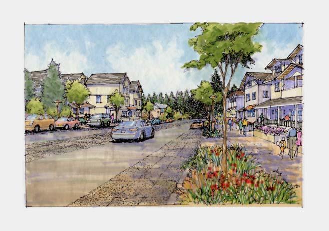
8 Illustrative Vision Plan Legend: Existing Buildings Development Parking/future infill Public facilities Infill in existing grid Parks, Open Space, Schools 11 Parks, Open Space & Circulation Concepts Park and public gathering place in each quadrant accessed from internal bike/ped connector loop street Primary throughput on 38th and Pine Internal bike/ped connector loop street connects 4 quadrants Reconnect grid with complete streets; LRT on Pine 12 6
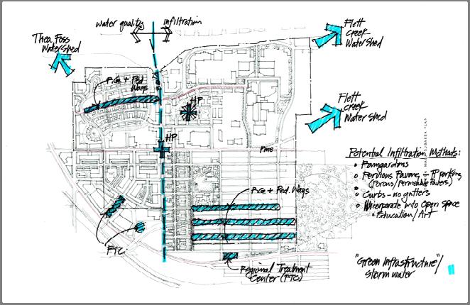
9 Stormwater Opportunities Green Street Concept 7

10 NEIGHBORHOOD STRUCTURE Scale Transition Concept Existing Zoning Potential in Project Area Potential Scale & Form Transition Concept for West of Mall Quadrant Current Zoning allows infill development of up to ten stories and a variety of uses in most areas of the neighborhood. Less responsive to scales and character. Disperses development activity and economic potential. Potential Neighborhood Transition concept allows higher density mixed use infill transitions to minimize impacts to existing residential areas. Concentrates development activity to create more cohesive place. 15 Neighborhood form key actions Create attractive and livable mixed use neighborhoods Recent growth not perceived as adding value Over zoned relative to anticipated growth Retain and build on neighborhood structure where present; establish structure where absent Differentiate form and scale between quadrants Strengthen human scale to build sense of place Establish hierarchy of streets & bike/ped thoroughfares Public gathering space for events & celebration Achieve multiple goals (open space, stormwater, connectivity, urban form) 16 8
11 Transportation key actions Reconnect the grid Complete streets retrofits & improved right of way design Incorporate linear park and green features into street system Improve access for regional and local traffic Create an internal bike/ped circulator loop Direct I 5 access to Tacoma Mall Boulevard Plan for consolidated Sound Transit LRT/Pierce Transit station Explore potential for Sounder Station on South Tacoma Way Mixed use walking streets 38 th, Steele, Pine Connect to other neighborhoods/bridge barriers Coordinate with transit service providers Develop design elements for 3 major corridors 17 Natural & Built Environment key actions Green infrastructure system for water quality & amenity treatment & infiltration Potential regional stormwater approaches Reduce greenhouse gas emissions with compact, mixed use walkable neighborhood Increase access to parks, play spaces & nature Increase area wide tree cover and landscaping Infill on existing paved areas & reconnect street grid 18 9

/parks as hubs Recruit businesses & facilities in desired locations (including local serving retail and services) Respond")


12 Economic Development key actions Leverage prime location while improving development outcomes & capturing the benefits of development Improve investment climate and development quality Make phased, strategic investments in streets, infrastructure, the public realm & sites Better calibrate zoning to respond to contemporary markets, lifestyle preferences & housing needs Leverage transit station(s)/parks as hubs Recruit businesses & facilities in desired locations (including local serving retail and services) Respond to changing retail dynamics integrate with neighborhood, broadened range of activities and uses Upfront SEPA review and project lists 19 Mall Quadrant Public gathering places, outdoor dining & entertainment Public & private street network Infill with mixed use, residential & structured parking Education, health care & employment potential LRT station on Pine west of Mall Public park on top of hill I 5 direct access to Tacoma Mall Boulevard Large scale development appropriate in this context Post Office may be catalyst site for redevelopment 20 10
 Retain")


13 West of Mall Neighborhood Transition scale from about 8 stories on 38th to lower scale to south (3 4 stories) Retain existing neighborhood block structure Revise development standards for private open space, parking and building street frontage Allow local serving retail & service Re integrate Madison School into neighborhood Complete streets, green streets & neighborhood park 21 NW Quadrant New Gateway/ Potential TOD Development Redeveloped area with new street pattern Oriented to concept of new Sounder Station on South Tacoma Way Large scale development pattern Take advantage of hillside for structured parking Use stormwater facilities as major new street/park character elements to establish highly urban district 22 11


14 NE Quadrant Transition wartime housing to low to medium density residential development; can occur over time while retaining key characteristics Potential to use curvilinear street pattern Oriented to topography Neighborhood parks create neighborhood places and separate area from more intense development to north & south Mixed use industrial area north of S. 35 th Street 23 Key Actions Summary Create neighborhood organizational structure for desired results (street networks, block size, parks & public spaces, scale) Carefully leverage all public investment & actions for multiple strategic benefits Plan for Light Rail & Sounder stations Regional stormwater facilities & green streets Complete streets/transportation projects major change to arterials, local circulator street, new street alignments Coordinated actions by Metro Parks and Tacoma School District & the business community More directive zoning for desired results 24 12


15 Key actions land use & zoning Fix the random, disjointed development pattern Consider regulating plan code vehicle to identify specific locations of street networks, parks & public places Require new streets with redevelopment Ensure that design standards promote goals Create more nuanced building scales and heights in different districts Retain existing residential characteristics of West of Mall and NE Quadrant Concentrate large scale mixed use development on 38th, in Mall & NW Quadrants 25 Potential Zoning Map Existing Zoning Map Potential Zoning Map & Street Grid 26 13


16 Next Steps Consultation withstakeholders Define EIS alternatives Refine and build on concepts as draft policy framework 27 14
City of Tacoma Planning and Development Services
 Agenda Item D-1 City of Tacoma Planning and Development Services To: Planning Commission From: Elliott Barnett, Planning Services Division Subject: Application #2014-08 Open Space Element Update Meeting
Tacoma Mall Neighborhood Subarea Plan & EIS. Planning Commission January 18, 2017
 Tacoma Mall Neighborhood Subarea Plan & EIS Planning Commission January 18, 2017 Objectives Develop one or more options for connectivity requirement What is the intent? Key considerations Range of options
Corridor Vision. 1Pursue Minnehaha-Hiawatha Community Works Project. Mission of Hennepin County Community Works Program
 1Pursue Minnehaha-Hiawatha Community Works Project Minnehaha-Hiawatha Community Works is a project within the Hennepin Community Works (HCW) program. The mission of the HCW program is to enhance how the
JANUARY 19, 2011 CENTRAL AVENUE-METRO BLUE LINE TRANSIT-ORIENTED DEVELOPMENT IMPLEMENTATION PROJECT COMMUNITY FORUM
 CENTRAL AVENUE-METRO BLUE LINE TRANSIT-ORIENTED DEVELOPMENT IMPLEMENTATION PROJECT COMMUNITY FORUM JANUARY 19, 2011 THE MARYLAND-NATIONAL CAPITAL PARK AND PLANNING COMMISSION PRINCE GEORGE S COUNTY PLANNING
Urban Design Manual PLANNING AROUND RAPID TRANSIT STATIONS (PARTS) Introduction. Station Study Areas
 Introduction. Station Study Areas") 111111 PLANNING AROUND RAPID TRANSIT STATIONS (PARTS) Introduction The ION rapid transit system will link Waterloo, Kitchener and Cambridge through a central transit corridor (CTC). There are a number
111111 PLANNING AROUND RAPID TRANSIT STATIONS (PARTS) Introduction The ION rapid transit system will link Waterloo, Kitchener and Cambridge through a central transit corridor (CTC). There are a number
New Partners for Smart Growth Conference February 5, 2010
 Dan Stroh, Planning Director City of Bellevue Planning and Community Development Bellevue, WA New Partners for Smart Growth Conference February 5, 2010 Summary of Project Long-range plan update for Bel-Red
A community driven catalyst for an equitable, healthy, (economically viable and environmentally) sustainable corridor
 sustainable corridor") Economy Environment Equity Building Sustainability Supporting neighborhoods Preserving municipal resources A community driven catalyst for an equitable, healthy, (economically viable and environmentally)
Economy Environment Equity Building Sustainability Supporting neighborhoods Preserving municipal resources A community driven catalyst for an equitable, healthy, (economically viable and environmentally)
D-O LRT Zoning Discussion. Chapel Hill Boards & Commissions October 16, 2017
 D-O LRT Zoning Discussion Chapel Hill Boards & Commissions October 16, 2017 Update on Overall D-O LRT Station Area Initiative Objectives Design and educate on principles of Good Transit-Oriented Development
CITY OF PUYALLUP. Background. Development Services
 CITY OF PUYALLUP Development Services 333 South Meridian Puyallup WA 98371 To: City Council From: Katie Baker, AICP, Planning Division Re: South Hill Neighborhood Plan Adoption Date: (Meeting date: February
Broken Arrow Comprehensive Plan Update Public Workshop Meeting #3 January 23,
 Broken Arrow Comprehensive Plan Update Public Workshop Meeting #3 January 23, September 25,2018 2018 26 April 2016 AGENDA 1. Status Presentation - Charrette Recap - Proposed Vision Framework - Preliminary
Chapter 1: Introduction
 Chapter 1: Introduction The Penn Avenue Community Works Corridor Vision and Implementation Framework presents an integrated communitybased vision and a coordinated, long-term implementation framework for
FUNDING CORRIDOR REVITALIZATION
 FUNDING CORRIDOR REVITALIZATION Integrated corridor planning for the 21 st Century America Planning Association Annual Conference Atlanta, GA April 27, 2014 Mariia Zimmerman, MZ Strategies, LLC mariia@mzstrategies.com
RE-Imagining the Downtown Colorado Springs Master Plan
 RE-Imagining the Downtown Colorado Springs Master Plan 2016 APA Colorado State Conference October 25, 2016 Overview 8:00 Welcome, Introductions, and Overview 8:15 Downtown s Planning History 8:30 A Market
PLAN ELEMENTS WORKSHOP. April 5, 2016
 PLAN ELEMENTS WORKSHOP April 5, 2016 needs more housing. But there is no one-size fits-all solution. Every neighborhood has its own character. In some places, density is not only appropriate it is badly
Implementation Guide Comprehensive Plan City of Allen
 Implementation Guide 2030 Comprehensive Plan City of Allen DRAFT 2015 Implementation Guide Allen 2030 Comprehensive Plan INTRODUCTION The Comprehensive Plan serves as a guide for the growth and development
Welcome to the Oakridge Centre Open House
 Welcome to the Oakridge Centre Open House Why is the City hosting this event? This open house is to inform you of a rezoning application submitted to the City of Vancouver to amend the existing CD-1 (Comprehensive
City of Tacoma Planning Commission
 City of Tacoma Planning Commission Chris Beale, Chair Stephen Wamback, Vice-Chair Donald Erickson Jeff McInnis Meredith Neal Anna Petersen Brett Santhuff Dorian Waller Scott Winship PRESENTATIONS and HANDOUTS
4.1.3 LAND USE CATEGORIES
 4.1.3 LAND USE CATEGORIES a. City Center District The City Center District incorporates the existing character and mix of uses in downtown Belmont to encourage redevelopment and new development in keeping
St. Louis Park Wooddale LRT Station Site development guidelines
 St. Louis Park Wooddale LRT Station Site development guidelines November 2013 OVERVIEW St. Louis Park s convenient location as a neighbor to Minneapolis means you re only minutes away from some of the
Rio/29 Small Area Plan. Design Plan & Implementation Framework Open House - January 25, 2018
 Rio/29 Small Area Plan Design Plan & Implementation Framework Open House - January 25, 2018 MEETING PURPOSE PRESENTATION 1. Orient to the updated design plans 2. Introduce implementing options 3. Explain
Plano Tomorrow Vision and Policies
 Plano Tomorrow Vision and Policies PLANO TOMORROW PILLARS The Built Environment The Social Environment The Natural Environment The Economic Environment Land Use and Urban Design Transportation Housing
Tacoma Mall Neighborhood Subarea Plan & EIS. Planning Commission February15, 2017
 Tacoma Mall Neighborhood Subarea Plan & EIS Planning Commission February15, 2017 1 Meeting objectives Commission direction on: Medium and Long-term visions Residential, neighborhood and housing topics
U T D N o r t h C a m p u s T O D and D o w n t o w n D e n t o n T O D
 U n i v e r s i t y o f T e x a s a t D a l l a s C i t y o f R i c h a r d s o n U T D N o r t h C a m p u s T O D and D o w n t o w n D e n t o n T O D Rick Leisner, AICP Assistant Director of Development
Atlanta BeltLine. Subareas 9 & 10. Master Plan Updates. March 26, Washington Park Jamboree 1
 Atlanta BeltLine Subareas 9 & 10 Master Plan Updates March 26, 2018 Washington Park Jamboree 1 22 miles, connecting 45 neighborhoods 22 MILES of transit 46 MILES of streetscapes and complete streets 33
2040 LUP is a part of the Comprehensive Plan and carries the same legal authority. Economic Challenges
 1.1. Guiding Anchorage s Growth Where will new residents settle over the next two decades? Where will people work, shop, and play? Will there be enough room to grow? How will Anchorage look? Will growth
FUTURE LAND USE ELEMENT
 FUTURE LAND USE ELEMENT GOAL I: To create and sustain a great place to live, play, and prosper Objective 1: The City of Ocala shall incorporate the principles and strategies of the Ocala 2035 Vision into
CITY OF CHARLOTTESVILLE, VIRGINIA CITY COUNCIL AGENDA
 CITY OF CHARLOTTESVILLE, VIRGINIA CITY COUNCIL AGENDA Agenda Date: December 16, 2013 Action Required: Adoption of Resolution Presenter: Staff Contacts: Title: James E. Tolbert, AICP, Director of NDS James
BROOKLYN PARK / 85TH AVE LRT STATION CDI DEVELOPMENT GUIDELINES DRAFT
 August 2018 Page intentionally left blank The Brooklyn Park Library adjacent to the 85th Ave LRT Station Area. OVERVIEW The Blue Line LRT Extension / Bottineau corridor offers a unique opportunity to leverage
Study Area. Capitol Way. Greening America s Capitals 11/13/2014. A Greening America s Capitals Project
 Olympia, WA: Greening Capitol Way Supporting Communities move towards sustainability is a priority for the federal government. A Greening America s Capitals Project Office of Sustainable Communities U.S.
Tonight s Agenda. 6:00 6:30 Welcome and Tour Panels with Team 6:30 7:30 Presentation 7:30 8:45 Break Out Session 8:45 9:30 Feedback & Next Steps
 Tonight s Agenda 6:00 6:30 Welcome and Tour Panels with Team 6:30 7:30 Presentation 7:30 8:45 Break Out Session 8:45 9:30 Feedback & Next Steps Welcome Public Open House #2 Tonight s Presentation Project
SAN RAFAEL GENERAL PLAN 2040 INTRODUCTION AND OVERVIEW
 SAN RAFAEL GENERAL PLAN 2040 INTRODUCTION AND OVERVIEW Steering Committee Presentation February 14, 2018 Purpose of General Plan Guide land use and development decisions Coordinate transportation, infrastructure,
Promoting Economic Development Through Upfront SEPA Review: Lessons from South Downtown Tacoma
 Promoting Economic Development Through Upfront SEPA Review: Lessons from South Downtown Tacoma 1 This session will focus on the City of Tacoma s South Downtown Subarea Plan and associated Non-Project SEPA
Blueprint Denver A BLUEPRINT FOR AN INCLUSIVE CITY. Executive Summary
 Blueprint Denver A BLUEPRINT FOR AN INCLUSIVE CITY Executive Summary PUBLIC REVIEW DRAFT 2 1/7/2019 DENVERIGHT BLUEPRINTDENVER Blueprint Denver: A Blueprint for an Inclusive City An Equitable City Planning
Atlanta BeltLine Subarea 3 Master Plan Update
 Atlanta BeltLine Subarea 3 Master Plan Update April 14, 2018 Workshop Meeting 1 22 miles, connecting 45 neighborhoods 22 MILES of transit 46 MILES of streetscapes and complete streets 33 MILES of urban
Robbinsdale LRT Station. CDI Development Guidelines. August Overview
 Robbinsdale LRT Station August 2018 Overview The City of Robbinsdale may have the coolest opportunity site along the 13 mile stretch of the Bottineau LRT corridor / Blue Line extension. Located a block
DOMINION BOULEVARD CORRIDOR STUDY AND ECONOMIC DEVELOPMENT STRATEGIC PLAN A MODEL FOR CHESAPEAKE S FUTURE
 DOMINION BOULEVARD CORRIDOR STUDY AND ECONOMIC DEVELOPMENT STRATEGIC PLAN A MODEL FOR CHESAPEAKE S FUTURE Overview I. Draft Plan Process II. Draft Plan Overview a. Market Analysis b. Master Land Use Plan
Wasatch CHOICE for 2040
 Wasatch CHOICE for 2040 Economic Opportunities We Can Choose a Better Future We enjoy an unparalleled quality of life along the Wasatch Front. People from all over the world are drawn to our stunning scenery,
City of Long Beach. creating vibrant and exciting places
 City of Long Beach creating vibrant and exciting places Land Use Element Urban Design Element Overview of the two draft General Plan elements Discuss areas of change Economic goals of the plans Case study
1 Welcome! UBC Okanagan Master Plan Update - Open House
 1 Welcome! UBC Okanagan Master Plan Update - Open House UBC is updating the Master Plan for the Okanagan Campus. The purpose of today s Open House is to: Present the draft 2015 Master Plan Answer any questions
CHAPTER 1. Ms. Guajardo s Class - Central Elementary CH 1 1
 INTRODUCTION CHAPTER 1 Ms. Guajardo s Class - Central Elementary CH 1 1 1.1 SETTING South Centre City is a linear corridor south of Downtown Escondido paralleling Centre City Parkway and South Escondido
Urban Development Area (UDA) Process in Virginia: History & Requirements
 Process in Virginia: History & Requirements") Urban Development Area (UDA) Process in Virginia: History & Requirements J. Kelli Nash Office of Intermodal Planning and Investment VDOT Coordinating Transportation & Land Use Forum Thursday, June 2, 2016
Urban Development Area (UDA) Process in Virginia: History & Requirements J. Kelli Nash Office of Intermodal Planning and Investment VDOT Coordinating Transportation & Land Use Forum Thursday, June 2, 2016
Silverdale Regional Center
 Silverdale Regional Center Vision for Silverdale Regional Center The Silverdale Regional Center Plan (Plan) will guide the evolution of the Silverdale Regional Center from a collection of strip malls and
Draft Cary Community Plan Review Part 3: Shop, Engage, Serve, Special Area Plans, Other Updates. October 27, 2015 Police Department Training Room
 Draft Cary Community Plan Review Part 3: Shop, Engage, Serve, Special Area Plans, Other Updates Committee for the Future October 27, 2015 Police Department Training Room AGENDA 1. Welcome and Call to Order
1 INTRODUCTION Purpose Project Background PROJECT CONTEXT Background The Capital City Downtown Plan...
 Attachment 3 Contents CONTENTS 1 INTRODUCTION... 3 Purpose... 3 Project Background... 3 2 PROJECT CONTEXT... 9 Background... 9 The Capital City Downtown Plan... 9 The LRT Expansion Plan - LRT Downtown
Hopkins. Development Guidelines May Overview. Sponsored by: Blake Road Corridor Collaborative City of Hopkins
 Hopkins Blake Road LRT Station Area Development Guidelines May 2015 Sponsored by: Blake Road Corridor Collaborative City of Hopkins Overview Hopkins is a dynamic community of over 17,000 residents located
WELCOME TO THE CHOUTEAU GREENWAY DESIGN, DEVELOPMENT AND CONSTRUCTION WORKING GROUP!
 WELCOME TO THE CHOUTEAU GREENWAY DESIGN, DEVELOPMENT AND CONSTRUCTION WORKING GROUP! Chouteau Greenway Steering Committee and Working Groups Overview Overview January 9, 2019 Chouteau Greenway will transform
Growth Management Planning in the Central Puget Sound Region. Today s Presentation. Puget Sound Region. New Partners for Smart Growth
 Growth Management Planning in the Central Puget Sound Region New Partners for Smart Growth Denver, CO January 2006 Today s Presentation Regional growth management in central Puget Sound, WA Regional geographies
A Plan for the Heart of the Region: Tukwila, WA
 : Tukwila, WA 1 The Plan orchestrates the Restructuring of a 1,000-acre Regional Shopping Area into a Social and Symbolic for the Region. REGIONAL CONTEXT Downtown Seattle (Metropolitan ) 20 miles Bellevue
Gold Line Bus Rapid Transit Transit Oriented Development (BRTOD) Helmo Station Area Plan
 Helmo Station Area Plan") Appendix F Gold Line Bus Rapid Transit Transit Oriented Development (BRTOD) Helmo Station Area Plan Introduction and Purpose of the Plan The Gold Line Bus Rapid Transit facility is an eleven-mile dedicated
Appendix F Gold Line Bus Rapid Transit Transit Oriented Development (BRTOD) Helmo Station Area Plan Introduction and Purpose of the Plan The Gold Line Bus Rapid Transit facility is an eleven-mile dedicated
ARLINGTON COUNTY, VIRGINIA
 ARLINGTON COUNTY, VIRGINIA County Board Agenda Item Meeting October 15, 2005 DATE: September 28, 2005 SUBJECT: Request to Advertise the adoption of the 2005 Clarendon Sector Plan C. M. RECOMMENDATION:
TRANSIT-ORIENTED DEVELOPMENT POLICY DRAFT. City Planning and Development Department Kansas City, Missouri
 TRANSIT-ORIENTED DEVELOPMENT POLICY DRAFT City Planning and Development Department Kansas City, Missouri What is Transit Oriented Development (TOD)? Development that focuses land uses around a transit
City of Lake Mary, Florida. Evolution of a Historic Downtown with Transit Oriented Development Strategies
 City of Lake Mary, Florida Evolution of a Historic Downtown with Transit Oriented Development Strategies What is Transit Oriented Development? Walkable villages located at and around transit stations in
Visioning Statement and Guiding Principles
 Visioning Statement and Guiding Principles Planning for the Future The General Plan The General Plan represents Woodland's shared vision of the future and defines a path to lead the community toward its
Potential Green Infrastructure Strategies May 6, 2015 Workshop
 Potential Green Infrastructure Strategies May 6, 2015 Workshop Background The City of Cortland is developing the Tioughnioga Urban Headwaters Green Infrastructure Action Plan with funding from the National
Attachment B: Centers and Corridors Proposal
 Attachment B: Centers and Corridors Proposal B. B This page is intentionally left blank. ATTACHMENT B: CENTERS AND CORRIDORS FRAMEWORK PROPOSAL B-2 Table of Contents Introduction... B-7 Focus Area... B-7
REVIEW AND EVALUATION OF REGIONAL LAND USE
 REVIEW AND EVALUATION OF REGIONAL LAND USE AND TRANSPORTATION SCENARIOS #220831 Environmental Justice Task Force October 7, 2014 VISION 2050 Process Development of Guiding Vision for Land Use and Transportation
ROBBINSDALE LRT STATION CDI DEVELOPMENT GUIDELINES
 August 2018 OVERVIEW The City of Robbinsdale has a prime-opportunity site in the middle of the 13 mile stretch of the Bottineau LRT corridor / Blue Line extension. Robbinsdale offers a prominent, vital,
Welcome! Agenda. South Downtown
 Welcome! Agenda 4:00 Open House 5:00 Presentation Welcome Subarea Plan Overview Existing Studies Next steps: Scoping 6:00 Questions and Answers 6:30 Open House continues Project background and purpose
Local Growth Planning in North Central Green Line Communities
 2018 April 30 Page 1 of 6 EXECUTIVE SUMMARY This report outlines a high-level scope for local growth planning for north central Green Line communities. The catalyst for this review is the significant investments
University of Saskatchewan CAMPUS MASTER PLAN. Senate Meeting Preliminary Presentation. April 21, 2018 DIALOG ECS DA WATT
 University of Saskatchewan CAMPUS MASTER PLAN Senate Meeting Preliminary Presentation April 21, 2018 DIALOG ECS DA WATT project process presentation agenda Stakeholder Engagement Project Control phase1
Town Center (part of the Comprehensive Plan)
") Town Center (part of the Comprehensive Plan) Mercer Island Town Center Looking North (2014) In 1994, a year-long process culminated in a set of design guidelines and code requirements for the Town Center
Town Center (part of the Comprehensive Plan) Mercer Island Town Center Looking North (2014) In 1994, a year-long process culminated in a set of design guidelines and code requirements for the Town Center
4- PA - LD - LIVELY DOWNTOWN. LD - Background
 4- PA - LD - LIVELY DOWNTOWN LD - Background The downtown has been the service centre for the community since the city s inception and the area continues to supply people with their personal services,
An advanced tool for assessing and guiding sustainable urban development
 Improving Transportation Demand Management through Sustainable Urban Planning and Design: Recommendations from International Green Model City Initiative (IGMC) Lu Haifeng Secretary-General Global Forum
Subregion 4 Central Avenue-Metro Blue Line Corridor Transit-Oriented Development (TOD) Implementation Project. Community Meeting April 27, 2011
 Implementation Project. Community Meeting April 27, 2011") Subregion 4 Central Avenue-Metro Blue Line Corridor Transit-Oriented Development (TOD) Implementation Project Community Meeting April 27, 2011 Overview Introduction to Subregion 4 TOD Implementation Program
Subregion 4 Central Avenue-Metro Blue Line Corridor Transit-Oriented Development (TOD) Implementation Project Community Meeting April 27, 2011 Overview Introduction to Subregion 4 TOD Implementation Program
Cumberland Region Tomorrow is a private, non-profit, citizen based regional organization working with Greater Nashville Regional Council
 Cumberland Region Tomorrow is a private, non-profit, citizen based regional organization working with Greater Nashville Regional Council and others in the public and private sectors, dedicated to planning
Cultivate Hopkins: Built Environment. Comprehensive Plan Advisory Committee September 13, 2017
 Cultivate Hopkins: Built Environment Comprehensive Plan Advisory Committee September 13, 2017 Four Dimensions of a Sustainable Plan Land Use Urban Design Housing Transportation Resilience Water Resources
Streets, Connectivity & Built Environment Working Group August 2, 2017
 Streets, Connectivity & Built Environment Working Group August 2, 2017 DOWNTOWN OAKLAND SPECIFIC PLAN WELCOME Streets, Connectivity & Built Environment Working Group Social Equity Meeting August 2, 2017
Danvers High Street I-1 District Study
 Danvers High Street I-1 District Study Presentation of Final Recommendations Planning Board Presentation June 26 th, 2018 1 Introductions Metropolitan Area Planning Council Sam Cleaves AICP, Principal
Hockessin Community Redevelopment Plan
 Hockessin Community Redevelopment Plan 3.1 Introduction The Community Redevelopment Plan for the Village of Hockessin is the result of the people s vision for a distinct village center that serves as the
The Five Components of the McLoughlin Area Plan
 The Five Components of the McLoughlin Area Plan This documents contains the complete language of the five components of the McLoughlin Area Plan: The Vision Statement The Values The Guiding Principles
Coliseum Station Area Area Redevelopment Plan. Public Engagement #1 June 12, 2017
 Coliseum Station Area Area Redevelopment Plan Public Engagement #1 June 12, 2017 Welcome Engagement Purpose Introduce the project Share information Gather input Project Updates & Newsletter edmonton.ca/coliseumplan
2035 General Plan Update and Belmont Village Specific Plan. Joint Study Session with the City Council and Planning Commission April 12, 2016
 2035 General Plan Update and Belmont Village Specific Plan Joint Study with the City Council and Planning Commission April 12, 2016 Agenda 1. Welcome and Introductions 2. General Plan Update Status of
Sustainability, Health, Safety, Recreation & Open Space Working Group August 3, 2017
 Sustainability, Health, Safety, Recreation & Open Space Working Group August 3, 2017 DOWNTOWN OAKLAND SPECIFIC PLAN WELCOME Sustainability, Health, Safety, Recreation & Open Space Working Group Social
ARISE: The Rock Renaissance Area Redevelopment & Implementation Strategy
 2014 Professional Awards 1 ARISE: The Rock Renaissance Area Redevelopment & Implementation Strategy Janesville, WI Completed December 2014 Analysis & Planning Purpose of Project 2 The purpose of the Rock
Economic Development & Housing Council Committee Comprehensive Plan Update September 20, 2005
 1 Economic Development & Housing Council Committee Comprehensive Plan Update September 20, 2005 Purpose To update the Committee on the ForwardDallas! Plan, including: Status Anticipated Products Public
EXPO LINE COMMUNITY WORKSHOPS NOVEMBER 27 TH & DECEMBER 3 RD Los Angeles Department of City Planning
 EXPO LINE COMMUNITY WORKSHOPS NOVEMBER 27 TH & DECEMBER 3 RD 2012 Los Angeles Department of City Planning Agenda for Tonight Open House 6:00 to 6:15pm Presentation and Questions 6:15 to 6:50 Small Group
Strategic plan framework Steering Committee Meeting
 Strategic plan framework Steering Committee Meeting September 26, 2018 1 agenda 1 Welcome and Strategic Planning introductions Process Strategic Analyses Plan Framework 2 3 Brand Brand Development Naming
Official Plan Review: Draft Built Form Policies
 PG.30.1 REPORT FOR ACTION Official Plan Review: Draft Built Form Policies Date: May 15, 2018 To: Planning and Growth Management Committee From: Chief Planner and Executive Director, City Planning Division
SQUAMISH 2010 AND BEYOND COMMUNITY VISION
 Our plan has been imagined and created to be both pragmatic and visionary. At the core of the strategy is a consideration of the highway s role and its impact on the community. First and foremost in creating
WELCOME TO THE CHOUTEAU GREENWAY ECONOMIC DEVELOPMENT WORKING GROUP!
 WELCOME TO THE CHOUTEAU GREENWAY ECONOMIC DEVELOPMENT WORKING GROUP! Chouteau Greenway Steering Committee and Working Groups Overview Overview January 9, 2019 Chouteau Greenway will transform St. Louis
Downtown by Design: The Bradenton CRA Master Plan. Glatting Jackson, Inc Robert Charles Lesser & Co. Downtown Bradenton Development Authority
 Downtown by Design: The Bradenton CRA Master Plan Glatting Jackson, Inc Robert Charles Lesser & Co. Downtown Bradenton Development Authority October 3, 2006 Our Goal for Today: Introduce Project Introduce
Plan Overview. Manhattan Area 2035 Reflections and Progress. Chapter 1: Introduction. Background
 Plan Overview The Manhattan Urban Area Comprehensive Plan (the Comprehensive Plan) is a joint planning initiative of the City of Manhattan, Pottawatomie County, and Riley County. The 2014 Comprehensive
Chapter 1.0 Introduction
 Chapter 1.0 Introduction 1.1 Background The North Metro commuter rail line is part of the RTD FasTracks regional transit system expansion program to build more than 100 miles of rail transit throughout
THE NEIGHBORHOOD TODAY
 THE NEIGHBORHOOD TODAY CORE AREA VISION How are we Good Urbanism A Site s DNA thinking about Elements of great Unique elements urban communities embedded in a place the site and design? ELEMENTS LIKE:
TREASURE COAST REGIONAL PLANNING COUNCIL M E M O R A N D U M. To: Council Members AGENDA ITEM 5H
 TREASURE COAST REGIONAL PLANNING COUNCIL M E M O R A N D U M To: Council Members AGENDA ITEM 5H From: Date: Subject: Staff October 17, 2008 Council Meeting Local Government Comprehensive Plan Review Draft
Denver Moves: Transit Task Force
 Insert transit picture Denver Moves: Transit Task Force Meeting #8 October 5, 2017 1. Welcome & Introductions Opening remarks and housekeeping Task Force and audience introductions Upcoming events and
Dyersville Downtown Plan. Open House October 24, 2017
 Dyersville Downtown Plan Open House October 24, 2017 What is a Comprehensive Plan? - Vision - Guidance for decisions - Basis for regulations What is a Downtown Plan? - Understand priorities - Identify
INDEPENDENCE BOULEVARD AREA PLAN. June 24, 2008
 INDEPENDENCE BOULEVARD AREA PLAN Public Meeting #1 June 24, 2008 Tonight s Agenda Introduction Welcome and Ground Rules Overview Presentation Purpose of the Plan What Brings Us Here? A Tour of the Corridor
PSRC REVIEW REPORT & CERTIFICATION RECOMMENDATION
 PSRC REVIEW REPORT & CERTIFICATION RECOMMENDATION KITSAP COUNTY COUNTYWIDE PLANNING POLICIES July 2, 2012 BACKGROUND A major emphasis of the Washington State Growth Management Act (GMA) is the need to
EXECUTIVE SUMMARY EXECUTIVE SUMMARY
 1 EXECUTIVE SUMMARY EXECUTIVE SUMMARY Penn s Landing is envisioned as a welcoming riverfront green space adjacent to a refurbished civic marina becoming the centerpiece for adjacent development. With a
The bottom urban structure and guidelines City Council Briefing
 The bottom urban structure and guidelines City Council Briefing 4.1.2015 1 Provide information on the studio s community planning and design efforts for The Bottom Review process to date Review plan recommendations
1 October Dear Citizens of Charlotte and Mecklenburg County,
 1 October 2011 Dear Citizens of Charlotte and Mecklenburg County, As co-chairs of the Center City 2020 Vision Plan Steering Committee, we are proud to present the Center City 2020 Vision Plan, which sets
CITY COUNCIL AGENDA REPORT
 CITY COUNCIL AGENDA REPORT Subject: COUNCIL MOTION LRT ALIGNMENT REMOVAL FROM THE TRANSPORTATION MASTER PLAN On February 10, 2016 Councillor Hughes provided notice in accordance with Section 23 of Procedure
Transportation Working Team Duane Diggs, Co-Chair (VOICE Buffalo) Kelly Dixon, Co-Chair (GBNRTC) Paul Ray, Facilitator (UB Regional Institute)
 Kelly Dixon, Co-Chair (GBNRTC) Paul Ray, Facilitator (UB Regional Institute)") towards a more sustainable Buffalo Niagara Transportation Working Team Duane Diggs, Co-Chair (VOICE Buffalo) Kelly Dixon, Co-Chair (GBNRTC) Paul Ray, Facilitator (UB Regional Institute) Agenda Welcome,
towards a more sustainable Buffalo Niagara Transportation Working Team Duane Diggs, Co-Chair (VOICE Buffalo) Kelly Dixon, Co-Chair (GBNRTC) Paul Ray, Facilitator (UB Regional Institute) Agenda Welcome,
City Council Special Meeting AGENDA ITEM NO. C.
 City Council Special Meeting AGENDA ITEM NO. C. DATE: 01/04/2019 TO: Honorable Mayor and City Council Members SUBJECT: Transit Villages Specific Plan project Study Session (Development Services Director
Northwest Rail Corridor and US 36 BRT Development Oriented Transit Analysis 4.4 STATION AREA FINDINGS
 4.4 STATION AREA FINDINGS Each station is different, and each one requires a separate set of recommendations based on the vision for the site. This section outlines an initial TOD strategy and recommendations
BeltLine Corridor Environmental Study
 BeltLine Corridor Environmental Study Citywide Conversation on Transit and Trails April 2, 2009 Agenda & Introductions Introductions Environmental Study Process Overview of the BeltLine Project BeltLine
Bethesda Downtown Plan
 Bethesda Downtown Plan Planning Board Update Connecticut Avenue Location Economic Sustainability Social Environmental Scope Coming Soon! Team Listening, Twitter Outreach We Are Here Engagement Challenge
ICLEI Webinar Sustainability in the Master Plan and Zoning Code
 ICLEI Webinar Sustainability in the Master Plan and Zoning Code Sustainability in Grand Rapids 2000 2002 New Master Plan 2004 2005 Neighborhood Pattern Workbook 2006 2007 Form-Based Zoning Ordinance 2007
Equitable Growth Through TOD Planning
 Equitable Growth Through TOD Planning Community Meeting # 2 November 2017 Goals Objectives Extend investment from downtown Connect neighborhoods physically and economically Enhance places based on local