Town Planning Report. Combined Planning Permit and Planning Scheme Amendment Request under Section 96A of the Planning and Environment Act 1987
|
|
|
- Walter Bond
- 6 years ago
- Views:
Transcription
 9429 6133 www.tract.")
1 Town Planning Report Combined Planning Permit and Planning Scheme Amendment Request under Section 96A of the Planning and Environment Act Henry Street, Belmont Prepared by Tract Consultants for Belmont Projects Pty Ltd PR01_25 November Lennox St, RICHMOND 3121 Phone: (03)
2 Executive Summary Background Applicant/Owner Address Belmont Projects Pty Ltd 1 Henry Street, Belmont Relevant Planning Controls State Planning Policy Framework Local Planning Policy Framework Strategic Planning Documents Clause 9 Plan Melbourne Clause 10 Operation of the State Planning Policy Framework Clause 11 Settlement Clause 13 Environmental Risks Clause 15 Built Environment and Heritage Clause 16 Housing Clause 17 Economic Development Clause 18 Transport Clause Key planning issues Clause Urban Growth Clause Liveability Clause Residential development Clause Housing Diversity Clause Economic Growth Clause Activity Centres Greater Geelong Housing Strategy Application Details Description of proposal Rezoning of land from Commonwealth Land to General Residential Zone, and the application of the Development Plan Overlay and the Environmental Audit Overlay, staged subdivision and construction of 2 or more dwellings on a lot. ii
3 Quality Assurance - Report Record Project Name Document Number Planning Report PR01 Revision (see below) 00 Prepared By Reviewed By Approved By Rachel Butler Jess Noonan Luke Chamberlain Date of Issue 25 November 2016 Revision Status- all revisions must be identified by the following information Revision Number 01 Description of Revision Prepared By Reviewed By Pages Revised Jess Noonan Luke Chamberlain All iii
4 Contents 1 Introduction Background Report Structure 2 2 Urban Context Review The Site Local Context 4 3 The Proposal Summary Rezoning Proposed Overlays 8 4 Planning Framework Ministerial Directions State Planning Policy Framework Local Planning Policy Framework Particular Provisions Other key Planning Considerations Practice Notes 12 5 Planning Assessment Strategic Assessment 13 6 Conclusion 17 1
5 1 INTRODUCTION 1.1 Background This report has been prepared on behalf of Belmont Projects Pty Ltd in relation to 1 Henry Street, Belmont, also known as Lot 1 on Title Plan (Site). The site is formally recognised as Volume Folio 272. The report supports a combined planning scheme amendment and planning permit application made under Section 96a of the Planning and Environment Act 1987 for: The rezoning of the Site to General Residential Zone Schedule 1; The application of the Development Plan Overlay to the Site; and, The construction of two or more dwellings on a lot, staged subdivision of land and removal of native vegetation. Council officers have agreed to consider this application, as well as considering the Development Plan prepared under the overlay. The Site is located in Belmont, within Greater Geelong. It is a single lot of approximately 6.20 hectares and is largely rectangular in shape. The Site has previously been used as the CSIRO Materials and Fibre Engineering laboratory. It is now surplus to the CSIRO needs and thus is under a contract of sale. The Site is unique in its large land holding size and presents a significant opportunity for more intensive development. The planning process for this Site commenced in 2011 with the proposed planning scheme amendment C251 which proposed to apply the Residential 1 Zone to the Site. The planning scheme amendment was supported, however the amendment was later abandoned as it was not able to proceed whilst the land remained in the ownership of the Commonwealth. A sale by tender process was therefore initiated for the Site to facilitate the sale of the land. This process included concept design and extensive background research and analysis. 1.2 Report Structure This report describes the Site and its context, analyses its opportunities and constraints and details the planning scheme amendment A separate report is provided to assess the proposed planning permit application for Stage 1. Clause 55 and Clause 56 assessments are included as appendices to this report. The reports also identify the relevant provisions of the Greater Geelong Planning Scheme and how the planning scheme amendment and planning permit application complies with it. 2
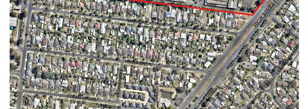
6 2 URBAN CONTEXT REVIEW 2.1 The Site Locality and Features The Site has historically been used by the CSIRO for Textile & Fibre Technology purposes. The site comprises a single land parcel, formally identified as Lot 1 on Title Plan , Volume Folio 272. As shown in Figure 1 Context Plan, the Site is located in Belmont, in close proximity to the Geelong CBD, adjacent to Corio-Waurn Ponds Road. The Site consists of one land parcel with a total area of 62,259 square metres. The site is generally rectangular in shape, with the exception of the eastern most corner which is irregularly shaped due to the alignment of Corio-Waurn Ponds Road. The Site has an extensive frontage to the Corio-Waurn Ponds Road, which allows for good exposure to passing traffic. Access to the Site is currently provided via a number of existing crossovers to Henry Street and one existing crossover to Corio-Waurn Ponds Road. For full site details refer to Appendix 1 Certificate of Title Interfaces The Site is situated between Corio-Waurn Ponds Road and Reynolds Road. The Site s immediate surrounds can be summarised as follows: North The northern boundary to the Site interfaces to Henry Street, a 15 metre wide residential access street which runs east west between Reynolds Road and Corio-Waurn Ponds Road. On the opposite side of Henry Street are low density houses. East The eastern boundary of the Site is to Corio-Waurn Ponds Road (formerly recognised as the Princes Highway) provides access north-east to South Geelong and further to the Geelong CBD, and south to Grovedale and the new alignment of the Princes Highway. South The Site shares a southern boundary with the rear boundaries of residential properties which front Marjorie Avenue. West The western boundary of the Site is to Reynolds Road, which runs generally north-south. On the opposite side of the road to the subject Site is the Clairvaux Catholic School. Adjacent to the School to the north-west of the Site is McDonald Reserve, a large open space reserve with two large football/cricket ovals, two netball courts and children s playground. Refer to Figure 2 Aerial Plan. 3
7 2.1.3 Landscape and Vegetation The Site currently has a number of existing trees and other existing vegetation on Site. All of this existing vegetation will be removed as part of the remediation of the site. Any offsets required for the vegetation will be provided as required Topography and Views The Site is falls from west to east, with a fall of 12 metres from the boundary at Reynolds Road to the Corio- Waurn Ponds Road boundary at the east of the Site. The Site does not currently enjoy any significant views Easements and Encumbrances The Site is not affected by any easements. 2.2 Local Context The Site is located adjacent to Corio-Waurn Ponds Road. The Site is approximately: 4km south-west of the City Centre of Geelong 2.5km from Marshall Station on the Warrnambool - Geelong train line 1.8km from Waurn Ponds Shopping Centre 2.2km from Epworth Geelong facility (due to open mid-2016) 3km from the Deakin University Waurn Ponds Campus Belmont is identified as a sub-regional Centre, which provides extensive employment opportunities as well as higher order retail services including the 24-Hour Kmart and the Belmont Village retail facilities. The Site is well serviced by arterial roads with direct frontage to the Corio-Waurn Ponds Road. The Corio- Waurn Ponds Road was formerly known as the Princes Highway or High Street in this location The Site is largely surrounded by conventional density residential lots to the north, south and west. The residential built form in the surrounding area is primarily characterised by one and two storey detached dwellings on lots averaging approximately 650sqm. Many of the surrounding local streets feature mature trees with the majority of dwellings set back from primary road frontages. The western boundary of the site is opposite to the Clairvaux Catholic School and the McDonald Reserve, providing a substantial area of open space for residents within the vicinity of the area. Refer to Figure 2 Context Plan. 4

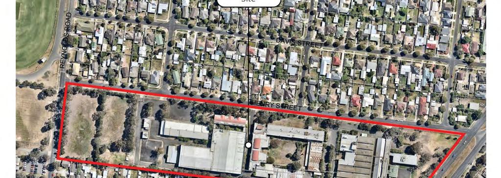
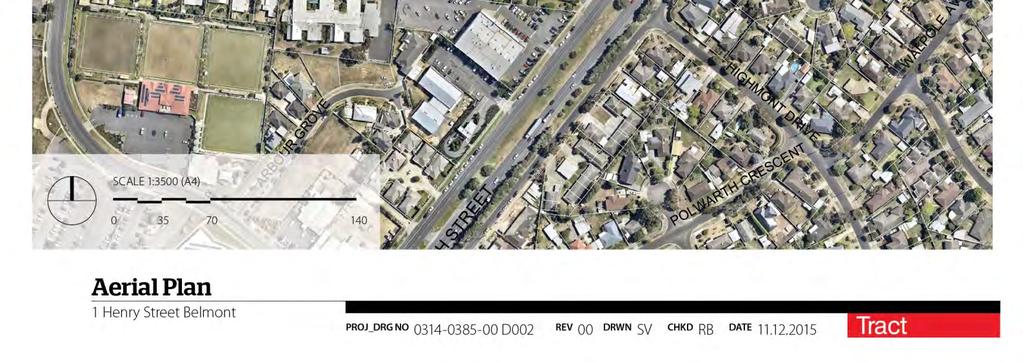
8 Figure 1 Aerial Plan 5

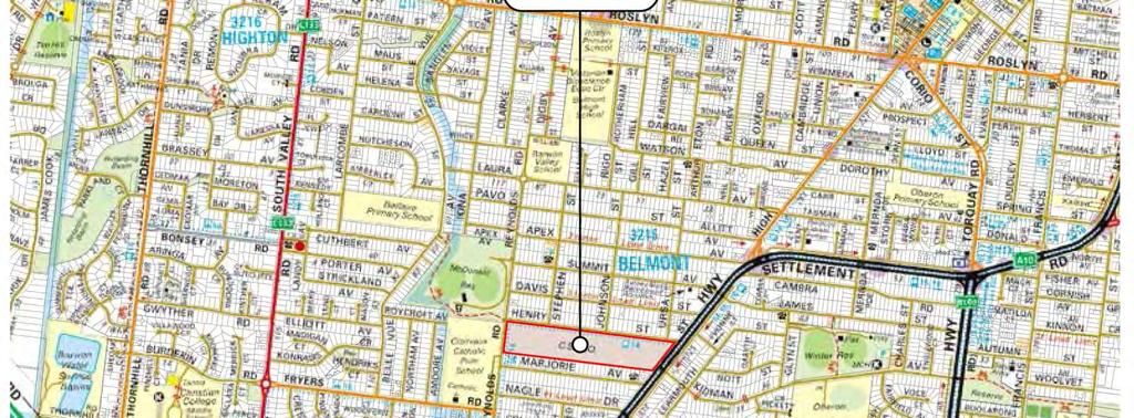
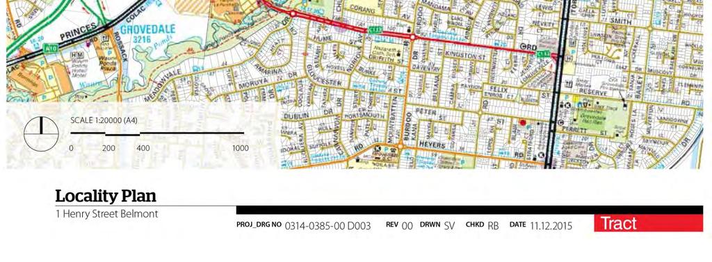
9 Figure 2 Locality Plan 6
10 3 THE PROPOSAL 3.1 Summary This Planning Scheme Amendment seeks to rezone the land, to apply the General Residential Zone to facilitate residential development of the site and apply the Development Plan Overlay and the Environmental Audit Overlay. The proposed rezoning will enable a transition of use and form appropriate to this locality. 3.2 Rezoning The site is not currently zoned as it is in the possession of the Commonwealth Government, therefore this amendment seeks to apply the General Residential Zone Schedule 1 (GRZ1) which seeks: To encourage development that respects the neighbourhood character of the area. To implement neighbourhood character policy and adopted neighbourhood character guidelines. To provide a diversity of housing types and moderate housing growth in locations offering good access to services and transport. To allow educational, recreational, religious, community and a limited range of other non-residential uses to serve local community needs in appropriate locations. The General Residential zone allows for a number of uses as-of-right, including Dwelling and Residential aged care facility. There are a number of Section 2 permit required uses in this zone which may be permitted subject to conditions. The application of the General Residential Zone Schedule 1 is appropriate to this Site facilitate the intended future built form. Schedule 1 to the General Residential Zone is titled General Residential Area, and makes no variations to the requirements of Clause 54 and 55 (Rescode). Given the transition of the land from commonwealth ownership to private ownership (Up Property), this rezoning will allow for future development of the site that appropriately reflects the strategic characteristics of the site. The context of the site located within an existing residential area is such that the existing research and technological uses are no longer representative of the potential for the site, or reflective of the envisaged future character for the area. The application of this zone is consistent with strategic directions identified within the Greater Geelong Planning Scheme. The rezoning will facilitate development of this site that is appropriate within the locality, appropriately responding to both the existing and envisaged future built form of the area. The Site is situated in close proximity to the Belmont Activity Centre, which is recognised as a subregional centre within Greater Geelong. 7


11 3.3 Proposed Overlays A Development Plan Overlay (DPO) and the Environmental Audit Overly (EAO) are proposed to be applied to the Site Development Plan Overlay The DPO will provide guidance for the future development of the Site, and provide certainty about the type of development that will be supported at this location. The purpose of the Development Plan Overlay is: To identify areas which require the form and conditions of future use and development to be shown on a development plan before a permit can be granted to use or develop the land. To exempt an application from notice and review if it is generally in accordance with a development plan A permit must not be granted to use or subdivide land, construct a building or construct or carry out works until a development plan has been prepared to the satisfaction of the responsible authority. A permit granted must: Be generally in accordance with the development plan. Include any conditions or requirements specified in a schedule to this overlay. The Development Plan for this Site has been prepared and is submitted to Council as part of this application Environmental Audit Overlay An EAO is proposed to be applied to the site and will ensure that the Site is appropriately remediated prior to any sensitive uses occurring on Site. The purpose of the Environmental Audit Overlay is: To ensure that potentially contaminated land is suitable for a use which could be significantly adversely affected by any contamination. Figure 3 Proposed GRZ1 Figure 4 Proposed EAO Figure 5 Proposed DPO 8
12 4 PLANNING FRAMEWORK 4.1 Ministerial Directions A Planning Scheme Amendment must respond to any relevant Ministerial Direction. The following Ministerial Directions are relevant to this amendment: Ministerial Direction No. 1 Potentially Contaminated Land Ministerial Direction No. 9 Metropolitan Strategy Ministerial Direction No. 11 Strategic Assessment of Amendments Ministerial Direction No.1 Potentially Contaminated Land Ministerial Direction No.1 requires that during the preparation of an amendment which would have the effect of allowing potentially contaminated land for a sensitive use, a planning authority must satisfy itself that the environmental conditions of the land are or will be suitable for that use Ministerial Direction No. 9 Metropolitan Strategy Ministerial Direction No. 9 seeks to ensure that all planning scheme amendments have regard to the Metropolitan Strategy, which in this direction refers to Plan Melbourne: Metropolitan Planning Strategy Ministerial Direction No. 11 Strategic Assessment of Amendments The purpose of this direction is to ensure a comprehensive strategic evaluation of a planning scheme amendment and the outcomes it produces is undertaken. A range of strategic considerations are outlined as forming a part of the evaluation criteria. An assessment of the proposal against the requirements of this direction is provided within Section 5 of this report. 4.2 State Planning Policy Framework To ensure planning schemes further the objectives of planning in Victoria, planning authorities must take into account and give effect to the general principles and specific policies contained in the State Planning Policy Framework (SPPF). The SPPF clauses that are most relevant to this proposed amendment are detailed below with responses indented. Clause 10 Operation of the State Planning Policy Framework encourages land use and development planning policies and practices which integrate relevant environmental, social and economic factors in the interests of net community benefit and sustainable development. This application will provide for increased direct employment opportunities and further direct, industrial and consumption effects estimated to increase by $58 million (REMPLAN Impact Report, 2015). Clause Supply of Urban Land seeks to ensure a sufficient supply of land is available for residential, commercial, retail, industrial, recreational, institutional and other community uses. 9
13 Clause 13 Noise and Air seeks to control noise effects on sensitive land uses and protect and improve air quality. Clause Urban Environment encourages the development of urban environments that are safe, functional and provide good quality environments with a sense of place and cultural identity. Clause Urban Design aims to create safe and functional urban environments which are good quality and which display a sense of place and cultural identity. Clause Design for safety aims to improve safety and encourage neighbourhood design that makes people feel safe. Clause Energy and Resource Efficiency encourages efficient land use and development which minimizes greenhouse gas emissions. Clause 16 Housing seeks to encourage new housing to locate in or close to activity centres and employment corridors, to meet the community s needs in terms of housing, identify strategic development sites for large residential development in Metropolitan Melbourne and to provide a range of housing types to meet the diverse needs of the community. Clause 17 Commercial seeks to encourage development which meet the communities needs for retail, entertainment, office and other commercial services and provides net community benefit in relation to accessibility, efficient infrastructure use and the aggregation and sustainability of commercial facilities. Clause 18 Transport seeks to promote an integrated transport system by way of land use and transport whilst also promoting sustainable personal transport, such as walking and cycling. Further to this, the Clauses that sit within this policy recognise the purpose of car parking and seek to ensure that an adequate supply of car parking is available. 4.3 Local Planning Policy Framework The LPPF clauses that are most relevant to this proposed amendment are detailed below with responses indented. Clause City of Greater Geelong Sustainable Growth Framework sets out key principles for ensuring that all actions and development undertaken in the City of Greater Geelong meets the needs of the present community without compromising the ability of future generations to meet their own needs. The key elements to the framework include; managing urban growth, building sustainable infrastructure, encouraging diversity in industry, and reducing greenhouse gas emissions Clause Municipal Framework Plan identifies key urban features of Geelong, including the sub-regional centre of Belmont and the nearby sub-regional centre of Grovedale. Clause Settlement and housing describes the demographics of Geelong as an ageing population through the in-migration of retirees and ageing-in-place of existing residents. It is therefore equally important that the City continues to provide an environment that attracts and supports children, young people and families. It also highlights that the demand for smaller dwelling types is expected to escalate and therefore provision of a range of housing typologies including units/townhouses/apartments should be encouraged. Clause Urban Growth reinforces the importance of limiting urban sprawl by directing urban growth to designated urban growth areas and maintaining appropriate urban land supplies. Clause Urban Consolidation seeks to provide for the consolidation of existing urban areas in a managed way, encourage a range of development densities whilst improving accessibility to urban services. Clause Neighbourhood character encourages development that respects the existing neighbourhood character and which limits the impact of urban change on existing neighbourhoods. Clause Discretionary Uses in Residential Areas aims to protect the amenity of the City s existing residential areas by seeking a balance between the need for goods and services that serve local residents and works and the potential for negative impacts on residential amenity. 10
14 4.4 Particular Provisions Although not relevant to the rezoning application, any future development application may need to have regard to the following particular provisions: Clause Public Open Space Contribution and Subdivision requires a public open space contribution be made to Greater Geelong City Council if the land is to be subdivided. The schedule to Clause specifies that for the subdivision of land zoned for residential purposes where the subdivision is for 10 or more lots on land zoned for residential purposed after 31 August 2007 is 10%. This can be provided using a combination of land and cash contributions. Clause Easements, Restrictions and Reserves enables the removal and variation of an easement to enable a use or development that complies with the planning scheme after the interests of affected people are considered. Clause Car parking seeks to ensure the provision of an appropriate number of car spaces having regard to the activities on the land and the nature of the locality. Clause Land adjacent to a Road Zone, Category 1 seeks to ensure appropriate access to identified roads and ensure appropriate subdivision of land adjacent to such roads. A permit is required to create or alter access to a road in a Road Zone Category 1, or to subdivide land adjacent to a road in a Road Zone, Category 1. Clause Bicycle Facilities seeks to encourage cycling as an alternative form of transport. This clause specifies the number of bicycle parking spaces that must be provided for each land use. Clause Integrated Public Transport Planning seeks to ensure that development supports public transport usage and that the new development can easily access a safe, attractive network and that new development does not adversely affect the efficiency of the existing network. Clause 55 Two or More dwellings on a lot and residential buildings applies to an application to construct a residential building. Clause 56 Residential Subdivision applies to an application to subdivide land in a residential zone that provides for residential development. 4.5 Other key Planning Considerations Housing Diversity Strategy (City of Greater Geelong, September 2008) The housing diversity strategy aims to: Provide for the development of a range of housing types and densities in the City of Greater Geelong, to meet the City s existing and future housing needs; Provide certainty to the existing and future community with regards to where different housing types and densities will be generally supported or discouraged by Council; and Provide for the development of a sustainable overall urban structure in the City of Greater Geelong. The strategy recognises a range of housing types that generally fall into the following categories: Conventional housing Single detached dwellings on lots generally ranging between 500 and 1,000 square metres (sqm). The development of an area for conventional housing generally results in a gross residential density1 of dwellings per hectare2 Medium density housing The provision of two or more detached or attached dwellings, townhouses or apartments on a site below four stories. The development of an area for medium density housing generally results in a gross residential density of dwellings per hectare. Higher Density housing Attached townhouses or apartments, usually more than 3 storeys in height. The development of an area for high density housing generally results in a gross residential density of more than 40 dwellings per hectare. The strategy highlights the growing population of Greater Geelong and the need to accommodate this growth. The City s aging population is highlighted as a key group that need to be accommodated now and in the future. There is an emphasis on reducing urban sprawl by encouraging development in existing urban areas, particularly areas that are well serviced by infrastructure and facilities. Ultimately this leads to less pollution, less environmental degradation, better accessibility to services and healthier communities. 11
15 4.6 Practice Notes PPN30 Potentially Contaminated Land General Practice Note, June 2005 This practice note provides guidance on managing land that is contaminated. It defines contaminated land and how it is considered in the planning scheme. The practice note also examines how potentially contaminated land is identified, what land uses or activities might indicate potential contamination, and what level of assessment is required. There is a history of industrial land uses on this site, and as such an Environmental Audit Overlay will be applied to the Site to ensure a more rigorous assessment is carried out prior to the commencement of any sensitive uses PPN46 Strategic Assessment Guidelines, June 2015 Minister s Direction No. 11 Strategic Assessment Guidelines requires a planning authority to evaluate and discuss how an amendment addresses a number of strategic considerations. This planning practice note explains what should be considered as part of the direction. A full assessment of the Planning Scheme Amendment against Ministerial Direction No. 11 is contained within Section PPN78 Applying the Residential Zones, June 2015 This planning practice note provides information and guidance to councils about the purposes and features of the residential zones, how to apply the residential zones and the schedules to the residential zones. The practice note specifies that applying the residential zones should be underpinned by clearly expressed planning policies in the planning scheme. The State Planning Policy Framework (SPPF) and Local Planning Policy Framework (LPPF) in the planning scheme should be the starting point for deciding whether the council s strategic objectives are still valid and sound, or whether new strategic work is required. Alternatively, a council may have undertaken relevant strategic planning for their residential areas. Table 1 of PN78 has been prepared to assist Councils implementation of new residential zones when preparing a planning scheme amendment. Excerpts from Table 1 those parts relevant to the Mixed Use Zone are reproduced below: Residential Zone Principles in Applying Zones Zone Purpose Likely Application Principles can be deduced from the purposes of Zones (and should be considered together)* GRZ Respects and preserves neighbourhood character while allowing moderate In most residential areas where moderate growth and diversity of housing that is consistent with existing neighbourhood character is to be provided Areas with a diversity of housing stock, diversity of lot sizes and a more varied neighbourhood character. Areas where moderate housing growth and housing diversity is encouraged. housing growth and diversity *Other principles and criteria may be required by councils to suit local circumstances. The application of the GRZ on this site accords with the principles for applying this zone. 12
16 5 PLANNING ASSESSMENT 5.1 Strategic Assessment This section of the planning report has been prepared in response to Section 3.1 of Ministerial Direction No. 11 under Section 12 (2)(a) of the Planning and Environment Act The purpose of the Strategic Assessment Guidelines is to provide a consistent framework for the evaluation of a proposed planning scheme amendment and the outcomes it produces. An assessment of the Planning Scheme Amendment against the Strategic Assessment Guidelines is provided below Why is an amendment required? The Amendment is required to facilitate the redevelopment of the land for residential and other land uses. The existing controls applying to the land do not accurately reflect the development potential of the site. This amendment will allow the site to better integrate with the existing urban context and to provide a more coordinated land use planning solution for the area. The amendment is informed by the Greater Geelong Planning Scheme and associated strategic planning documents and proposes to redevelop the land for residential purposes. The Site is an isolated Commonwealth land area that is situated adjacent to land zoned General Residential Zone and also bordered by land in a Road Zone, Category 1. The former CSIRO use has now ceased, and as such the absence of zoning on the land no longer accurately reflects the intended future use of the Site. It is proposed to rezone the Site to the Residential Growth Zone, which will facilitate future development of the Site for residential purposes, which will include a variety of residential densities and built forms, and areas of open space. The proposed zone will also allow the Site to be developed and used in a manner which is consistent with the Greater Geelong Planning Policy, and that fulfills the objectives of the Greater Geelong Housing Diversity Strategy How does the amendment implement the objectives of planning in Victoria? The amendment implements the objectives of planning in Victoria, contained in Section 4 of the Planning and Environment Act 1987, in the following ways: Objective A: the amendment provides for the fair, orderly, economic and sustainable use and development of land as it facilitates a coordinated development in a strategically identified location and in a responsible manner through the implementation of an appropriate zone. Objective B: the amendment facilitates an efficient use of resources within an established area. This naturally reduces pressure on fringe development. Objective C: the amendment will secure and provide a pleasant and safe living environment. Objective D: the amendment does not modify any areas of existing heritage. Objective F: the amendment will enable appropriate consolidation of the Site in accordance with state planning policy for activity centre development. 13
17 Objective G: the amendment seeks to balance the present and future interests of all Victorians by facilitating capital investment in the Greater Geelong region and facilitating a high quality residential development How does the amendment address the environmental effects and any relevant social and economic effects? The amendment will generate positive social and economic benefits through significant job creation in the construction industry The total output for this development is estimated at $73 million dollars, from which total output, including all direct, industrial and consumption effects is estimated to increase by up to $178 million. The amendment provides for development which better meets community needs and demands for housing and associated uses. It provides for residential land use which is consistent with the surrounding residential land use of the locality. The General Residential Zoning will also allow for other possible future uses including retail at the interface of Corio-Waurn Ponds Road. The focus on development of land near activity centres helps to make the best use of state and local infrastructure, and to improve access and equity to services. The amendment will facilitate the provision of housing in close proximity to employment opportunities and the Principal Public Transport Network which will reduce the reliance on personal motor vehicle trips. The amendment ensures the environmental condition of the land is properly investigated and managed in accordance with the Environmental Protection Act Does the amendment comply with the requirements of any other Minister s Direction applicable to the amendment? The amendment is consistent with the Ministerial Direction on the Form and Content of Planning Schemes under Section 7(5) of the Planning and Environment Act It also meets the requirements of the following relevant Ministerial Directions, in the following ways: Ministerial Direction No.1 Potentially Contaminated Land by applying an Environmental Audit Overlay on the site. Ministerial Direction No. 11 Strategic Assessment of Amendments The purpose of this direction is to ensure a comprehensive strategic evaluation of a planning scheme amendment and the outcomes it produces. This assessment meets the requirements of this Direction. Ministerial Direction No. 15 The Planning Scheme Amendment Process The purpose of this Direction is to set times for completing steps in the planning scheme amendment process. It applies to the Minister for Planning, the Secretary to the Department, Panels appointed under Part 8 of the Planning and Environment Act 1987 (Act), and all planning authorities in Victoria. The Minister may grant an exemption from the need to comply with one or more of the requirements of the Direction in relation to a particular amendment. Ministerial Direction No. 16 Residential Zones The purpose of this Direction is to direct planning authorities about applying the Residential Growth Zone, General Residential Zone and Neighbourhood Residential Zone through a planning scheme amendment How does the amendment support or implement the State Planning Policy Framework? The amendment upholds the principles and objectives of the State Planning Policy Framework. It has the potential to enhance the offering of residential accommodation within Greater Geelong in a location that is well suited to residential development. In particular, the amendment implements key policy directions of the SPPF by: Achieving settlement objectives with the removal or existing conflict of land uses; Urban consolidation to promote population growth in close proximity to established services and facilities; Opportunities for good quality, energy efficient urban design; Providing for employment opportunities; Providing for added value in this location; More efficient use of existing infrastructure; 14
18 Enhancing the noise and air quality of the neighbourhood by converting an industrial site into a residential site; Facilitating development within an existing urban area rather than on the fringe; Identifying a strategic redevelopment site; Facilitating higher density residential development within close proximity to an activity centre to maximise the significant investment that has already been made in existing infrastructure and services; Reducing the cost of living by increasing housing supply near services and public transport; Facilitating the supply of housing that is affordable; and Not impacting upon places of Aboriginal cultural heritage significance Does the amendment support or implement the LPPF? If not, how is the LPPF proposed to change? The amendment upholds the objectives and strategies of the Local Planning Policy Framework. No changes are required to the LPPF to facilitate the redevelopment of the Site for residential purposes. In particular, the amendment implements key policy directions of the LPPF by: Addressing rapid population growth within the municipality and addressing housing diversity, liveability, transport and urban design issues through the more appropriate zoning of a key strategic site. Minimising the risk for land use conflicts between the existing residential and industrial/technology areas. Allowing for residential development that increase housing diversity and reflects the overall community needs within the well serviced, established Belmont area. Providing infill development which is of high design quality and responds to the locality. Providing the opportunity to develop the site for a diversity of housing styles and designs. Managing population growth by unlocking underutilised land in close proximity to an activity centre that is fit and ready for residential development. Protecting environmentally significant areas of the municipality by directing population growth to a site that is relatively unconstrained and ripe for redevelopment. Protecting the quality and character of the urban environment through the appropriate overlay controls to guide built form Does the amendment make proper use of the Victoria Planning Provisions? The Amendment makes proper use of the VPPs through the implementation of the General Residential Zone (DPO), Environmental Audit Overlay (EAO) and the Development Plan Overlay (DPO). The application of the General Residential Zone will provide an appropriate framework for the future use and development of the site. The application of the Development Plan Overlay will ensure that buildings and works are in accordance with the overall vision and intended design outcomes for the site, and provide for a coordinated approach to development. Applications for buildings and/or works which are in accordance with the provisions of the DPO will be exempt from notice requirements. This approach is reasonable given the certainty as to built form outcomes provided by the format and content of the controls. The proposed combination of planning controls provides an appropriate level of certainty for Council and the community as to the use and development outcomes that can be expected on the site How does the amendment address the views of any relevant agency? The amendment is consistent with the overriding objectives of the Department of Environment, Land, Water and Planning in relation to Plan Melbourne and sustainable urban development. The views of relevant agencies will be sought and considered through the preparation of the planning scheme amendment. 15
19 The exhibition of this amendment will provide a formal opportunity for all relevant stakeholders to provide comment on the proposal Does the amendment address the requirements of the Transport Integration Act 2010? The Transport Integration Act 2010 establishes a framework for the provision of an integrated and sustainable transport system in Victoria. The Act provides for a system in which all transport activities and modes work together and recognises the interdependency of transport and land use. The amendment complies with the relevant requirements of the Transport Integration Act, specifically Part 2, Division 2, 11 Integration of transport and land use. The amendment will facilitate development which integrates with and promotes a sustainable transport system to better address transport accessibility, housing affordability and sustainable communities. This integration will ensure that the transport system is able to support the land use outcomes as foreshadowed by this amendment and similarly that the proposed land use patterns support the use of an integrated transport system What impact will the new planning provisions have on the resource and administrative costs of the responsible authority? Consideration of a planning permit application will place some additional demand on the responsible authority, although there will not be any unreasonable ongoing demands. 16
20 6 CONCLUSION This report has detailed a planning scheme amendment application to the Greater Geelong Planning Scheme. The proposed rezoning is underpinned by state and local planning policy. It represents well-considered urban consolidation that will reduce pressure on fringe development and areas not fit and ready for increased density. The Site is strategically located in close proximity to the existing Belmont sub-regional activity centre. The Site is well placed to support the proposed residential development, particularly in regards to the existing residential areas that surround the Site. Council is respectfully requested to forward this rezoning request to the Minister for Planning pursuant to section 8A (2) of the Planning and Environment Act 1987 to seek authorisation to formally prepare and exhibit the amendment. 17
DAREBIN PLANNING SCHEME AMENDMENT C137
 Who is the planning authority? Planning and Environment Act 1987 DAREBIN PLANNING SCHEME AMENDMENT C137 EXPLANATORY REPORT This amendment has been prepared by the Darebin City Council, who is the planning
INCREMENTAL CHANGE AREA REVIEW March 2015 Page 1
 INCREMENTAL CHANGE AREA REVIEW March 2015 Page 1 Table of Contents Introduction... 3 Background to Review... 3 Comparison of the Schedules to the General Residential Zone... 7 Methodology... 7 Policy Context...
Greater Geelong Planning Scheme Proposed Planning Scheme Amendment C and 5-19 Princes Highway, Norlane
 Greater Geelong Planning Scheme Proposed Planning Scheme Amendment C253 PLANNING SUBMISSION prepared for Bunnings Group Ltd by SJB Planning Pty Ltd Level 1, Building D 80 Dorcas Street SOUTHBANK VIC 3006
Casey Planning Scheme Amendment C207 Part 2 Evan and Margaret Street Precinct, Berwick
 Planning and Environment Act 1987 Panel Report Casey Planning Scheme Amendment C207 Part 2 Evan and Margaret Street Precinct, Berwick 14 January 2019 Planning and Environment Act 1987 Panel Report pursuant
DRAFT PLANNING SCHEME AMENDMENT GC81
 Outline of changes proposes to the Melbourne and Port Phillip Planning Scheme Fishermans Bend Fishermans Bend is one of several priority precincts identified in Plan Melbourne and plays a central role
CITY OF FREMANTLE LOCAL PLANNING SCHEME NO. 4 AMENDMENT NO. 68 SCHEME AMENDMENT REPORT
 CITY OF FREMANTLE LOCAL PLANNING SCHEME NO. 4 AMENDMENT NO. 68 SCHEME AMENDMENT REPORT CITY OF FREMANTLE PLANNING AND DEVELOPMENT SERVICES 8 WILLIAM STREET FREMANTLE WA 6160 PLANNING AND DEVELOPMENT ACT
I539. Smales 2 Precinct
 I539. Smales 2 Precinct I539.1. Precinct Description The Smales 2 Precinct applies to a 4.8 hectare block of land located on the southern side of Northcote Road and fronting Lake Pupuke, Takapuna. The
ONTARIO MUNICIPAL BOARD
 PL 120483 ONTARIO MUNICIPAL BOARD Applicant/Appellant: 2124123 Ontario Limited Subject: OPA, Rezoning and Draft Plan of Subdivision Municipal Address: 3940 Highway 7 East Municipality: City of Markham
Planning Proposal Wangi Power Station Complex Administrative Amendment Lake Macquarie Local Environmental Plan 2014
 Planning Proposal Wangi Power Station Complex Administrative Amendment Lake Macquarie Local Environmental Plan 2014 (Post Exhibition Version) Local Government Area: Name of Draft LEP: Subject Land: Land
Land Use Amendment in Southwood (Ward 11) at and Elbow Drive SW, LOC
 at and Elbow Drive SW, LOC") 2018 November 15 Page 1 of 10 EXECUTIVE SUMMARY This land use amendment application was submitted by Rick Balbi Architect on 2017 August 31 on behalf of Sable Developments Ltd, and with authorization from
2018 November 15 Page 1 of 10 EXECUTIVE SUMMARY This land use amendment application was submitted by Rick Balbi Architect on 2017 August 31 on behalf of Sable Developments Ltd, and with authorization from
4 RESIDENTIAL ZONE. 4.1 Background
 4 RESIDENTIAL ZONE 4.1 Background The residential areas within the City are characterised by mainly lowrise dwellings sited on individual allotments. Past architectural styles, settlement patterns and
I615. Westgate Precinct
 I615. Westgate Precinct I615.1. Precinct Description The Westgate Precinct is located approximately 18km west of the Auckland city centre. There are seven Sub-precincts in the Westgate Precinct: Sub-precinct
The Proposed Auckland Unitary Plan (notified 30 September 2013)
") 3 Business zones Introduction There are 10 business zones in the Unitary Plan: City Centre Metropolitan Centre Town Centre Local Centre Neighbourhood Centre Mixed Use General Business Business Park Light
3 Business zones Introduction There are 10 business zones in the Unitary Plan: City Centre Metropolitan Centre Town Centre Local Centre Neighbourhood Centre Mixed Use General Business Business Park Light
SCHEDULE THREE TO THE DEVELOPMENT PLAN OVERLAY EASTERN GOLF COURSE KEY REDEVELOPMENT SITE
 DD/MM/YY SCHEDULE THREE TO THE DEVELOPMENT PLAN OVERLAY Shown on the planning scheme map as DPO3 EASTERN GOLF COURSE KEY REDEVELOPMENT SITE 1.0 A permit may be granted before a development plan has been
ROAD CLOSURE AND LAND USE AMENDMENT SILVER SPRINGS (WARD 1) NORTHEAST OF NOSEHILL DRIVE NW AND SILVER SPRINGS ROAD NW BYLAWS 2C2018 AND 29D2018
 NORTHEAST OF NOSEHILL DRIVE NW AND SILVER SPRINGS ROAD NW BYLAWS 2C2018 AND 29D2018") Page 1 of 19 EXECUTIVE SUMMARY This application proposes redesignating two parcels in the community of Silver Springs from Special Purpose Future Urban Development (S-FUD) District and undesignated road
Page 1 of 19 EXECUTIVE SUMMARY This application proposes redesignating two parcels in the community of Silver Springs from Special Purpose Future Urban Development (S-FUD) District and undesignated road
Lake Macquarie City. A copy of the published amendment including the instrument and maps, is provided in Attachment 7 of this report.
 Planning Proposal Amendment No. 77 to Lake Macquarie Local Environmental Plan 2004 and proposed Amendment to Draft Lake Macquarie Local Environmental Plan 2013 Minor Zone Boundary Adjustment - Pasminco
TABLE OF CONTENTS. Human Habitats, 155 Dorcas St South Melbourne, Victoria 3205
 TARNEIT JUNCTION Town Planning Report DECEMBER 2013 TABLE OF CONTENTS Table of contents... 1 1 Introduction... 2 2 SIte context and surrounds... 4 2.1 Site Features... 4 2.2 Surrounding land uses... 4
Appendix 1 Structure plan guidelines
 Appendix 1 Structure plan guidelines This appendix forms part of the regional policy statement [rps]. 1.1. Introduction Structure plans are an important method for establishing the pattern of land use
6 Growth Management Challenges and Opportunities
 6 Growth Management Challenges and Opportunities The Town has established a goal of attaining a 50% participation rate with respect to employment opportunities versus residential population. The Town s
LAND USE AMENDMENT CORNERSTONE (WARD 3) 60 STREET NE AND COUNTRY HILLS BOULEVARD NE MAP 26NE BYLAW 22D2017
 60 STREET NE AND COUNTRY HILLS BOULEVARD NE MAP 26NE BYLAW 22D2017") Page 1 of 14 EXECUTIVE SUMMARY This Land Use Amendment application covers an area of 43.76 hectares ± (108.14 acres ±) located in northeast Calgary, bound by Country Hills Boulevard NE to the south and
Page 1 of 14 EXECUTIVE SUMMARY This Land Use Amendment application covers an area of 43.76 hectares ± (108.14 acres ±) located in northeast Calgary, bound by Country Hills Boulevard NE to the south and
EAST VILLAGE STRATEGIC SITE NOVEMBER 2017
 EAST VILLAGE STRATEGIC SITE NOVEMBER 2017 East Village will be a sustainable, mixeduse precinct with a focus on innovative employment and education opportunities. Enhanced by green spaces and places for
Planning Proposal Concurrent DA/LEP Amendment for Belmont North Pharmacy Amendment No. 24 to Lake Macquarie Local Environmental Plan (LMLEP) 2014
 2014") Planning Proposal Concurrent DA/LEP Amendment for Belmont North Pharmacy Amendment No. 24 to Lake Macquarie Local Environmental Plan (LMLEP) 2014 Local Government Area: Name of Draft LEP: Subject Land:
Planning Proposal Concurrent DA/LEP Amendment for Belmont North Pharmacy Amendment No. 24 to Lake Macquarie Local Environmental Plan (LMLEP) 2014 Local Government Area: Name of Draft LEP: Subject Land:
Tāhuhu whakaruruhau ā-taone The sheltering ridge pole
 B2. Tāhuhu whakaruruhau ā-taone - Urban growth and form B2.1. Issues Tāhuhu whakaruruhau ā-taone The sheltering ridge pole Auckland s growing population increases demand for housing, employment, business,
Planning Proposal Charlestown Swim and Leisure Centre LEP Amendment
 Planning Proposal Charlestown Swim and Leisure Centre LEP Amendment Amendment No. 4 to Lake Macquarie Local Environmental Plan 2014 (PP_2014_LAKEM_005_00) Local Government Area: Name of Draft LEP: Lake
178 Carruthers Properties Inc.
 178 Carruthers Properties Inc. Planning Rationale for 178 Carruthers Avenue Site Plan Control Application June 2014 Table of Contents 1.0 Introduction 2.0 Overview of Subject Property 3.0 Current Zoning
Appendix 7 Precinct Analysis Carlton
 Appendix 7 Precinct Analysis Carlton (Andover Street) Rezone from R2 Low Density Residential to R3 Medium Density Residential Retain existing B1 Neighbourhood Centre zone Existing Zoning Map (R2 Low Density
LAND USE AMENDMENT DOWNTOWN COMMERCIAL CORE (WARD 7) MACLEOD TRAIL SE AND 5 AVENUE SE BYLAW 254D2017
 MACLEOD TRAIL SE AND 5 AVENUE SE BYLAW 254D2017") Page 1 of 10 EXECUTIVE SUMMARY This Land Use Amendment application seeks to redesignate a full downtown block (currently the YWCA site) from a Direct Control based on the CM-2 District (Land Use Bylaw
Page 1 of 10 EXECUTIVE SUMMARY This Land Use Amendment application seeks to redesignate a full downtown block (currently the YWCA site) from a Direct Control based on the CM-2 District (Land Use Bylaw
Northern Territory Compact Urban Growth Policy
 Northern Territory Compact Urban Growth Policy A Reference Policy Document to clause 2.7 (Reference to Policy) of the NT Planning Scheme May 2015 Table of Contents 1 Policy Setting... 3 1.1 Context for
Planning Proposal Toronto Road, Booragul. Amendment to Lake Macquarie Local Environmental Plan (LMLEP) 2014
 2014") Planning Proposal Toronto Road, Booragul Amendment to Lake Macquarie Local Environmental Plan (LMLEP) 2014 Local Government Area: Name of Draft LEP: Subject Land: Land Owner: Applicant: Folder Number:
Planning Proposal Toronto Road, Booragul Amendment to Lake Macquarie Local Environmental Plan (LMLEP) 2014 Local Government Area: Name of Draft LEP: Subject Land: Land Owner: Applicant: Folder Number:
Plan Modification to Chapter B2 of the Auckland Unitary Plan(AUP) Operative in part (15 November 2016)
 Operative in part (15 November 2016)") UNITARY PLAN UPDATE REQUEST MEMORANDUM TO FROM Phill Reid Linley Wilkinson DATE 25 September 2018 SUBJECT Plan Modification to Chapter B2 of the Auckland Unitary Plan(AUP) Operative in part (15 November
UNITARY PLAN UPDATE REQUEST MEMORANDUM TO FROM Phill Reid Linley Wilkinson DATE 25 September 2018 SUBJECT Plan Modification to Chapter B2 of the Auckland Unitary Plan(AUP) Operative in part (15 November
POLICY AMENDMENT AND LAND USE AMENDMENT KILLARNEY/GLENGARRY (WARD 8) NW CORNER OF RICHMOND ROAD AND 33 STREET SW BYLAWS 1P2015 AND 7D2015
 NW CORNER OF RICHMOND ROAD AND 33 STREET SW BYLAWS 1P2015 AND 7D2015") Page 1 of 13 EXECUTIVE SUMMARY This application seeks to redesignate an RC-2 (Residential Contextual One/Two Dwelling) parcel to MC-Gd72 (Multi-Residential Contextual Grade-Oriented) to allow for multi-residential
Page 1 of 13 EXECUTIVE SUMMARY This application seeks to redesignate an RC-2 (Residential Contextual One/Two Dwelling) parcel to MC-Gd72 (Multi-Residential Contextual Grade-Oriented) to allow for multi-residential
Draft Western District Plan
 Powered by TCPDF (www.tcpdf.org) Draft Western District Plan Submission_id: 31440 Date of Lodgment: 15 Dec 2017 Origin of Submission: Online Organisation name: Goodman Property Services Australia Pty Ltd
GREENBANK DEVELOPMENT MASTERPLAN
 DEVELOPMENT MASTERPLAN POTENTIAL TRAIN STATION COMMUNITY CENTRE Greenbank will be a connected masterplanned community providing easy access to local and surrounding amenity. Affordable quality homes, green
POLICY AMENDMENT AND LAND USE AMENDMENT TUXEDO PARK (WARD 9) CENTRE STREET N AND 26 AVENUE NE BYLAWS 36P2017 AND 234D2017
 CENTRE STREET N AND 26 AVENUE NE BYLAWS 36P2017 AND 234D2017") Page 1 of 11 EXECUTIVE SUMMARY This application proposes to redesignate a single parcel of land in the Community of Tuxedo Park from Commercial Corridor 2 (C-COR2 f1h10) District to Mixed Use Active Frontage
Page 1 of 11 EXECUTIVE SUMMARY This application proposes to redesignate a single parcel of land in the Community of Tuxedo Park from Commercial Corridor 2 (C-COR2 f1h10) District to Mixed Use Active Frontage
LAND USE AMENDMENT CORNERSTONE (WARD 3) COUNTRY HILLS BOULEVARD AND STONEY TRAIL NE BYLAW 9D2017
 COUNTRY HILLS BOULEVARD AND STONEY TRAIL NE BYLAW 9D2017") Page 1 of 12 EXECUTIVE SUMMARY This Land Use Amendment application covers an area of 54.92 hectares ± (135.71 acres ±) located in northeast Calgary, bound by Country Hills Boulevard NE to the north and
Page 1 of 12 EXECUTIVE SUMMARY This Land Use Amendment application covers an area of 54.92 hectares ± (135.71 acres ±) located in northeast Calgary, bound by Country Hills Boulevard NE to the north and
FORMER CANADIAN FORCES BASE (CFB) ROCKCLIFFE SECONDARY PLAN. Official Plan Amendment XX to the Official Plan for the City of Ottawa
 ROCKCLIFFE SECONDARY PLAN. Official Plan Amendment XX to the Official Plan for the City of Ottawa") FORMER CANADIAN FORCES BASE (CFB) ROCKCLIFFE SECONDARY PLAN Official Plan Amendment XX to the Official Plan for the City of Ottawa 1 INDEX THE STATEMENT OF COMPONENTS PART A THE PREAMBLE PAGE Purpose...
FORMER CANADIAN FORCES BASE (CFB) ROCKCLIFFE SECONDARY PLAN Official Plan Amendment XX to the Official Plan for the City of Ottawa 1 INDEX THE STATEMENT OF COMPONENTS PART A THE PREAMBLE PAGE Purpose...
Draft Eastern District Plan
 Draft Eastern District Plan Submission_id: 31238 Date of Lodgment: 13 Dec 2017 Origin of Submission: Online Organisation name: Turrulla Gardens Pty Ltd C/- Mecone Organisation type: Industry First name:
Edward R. Sajecki Commissioner of Planning and Building
 Corporate Report Clerk s Files Originator s Files CD.03.POR DATE: TO: FROM: SUBJECT: Chair and Members of Planning and Development Committee Meeting Date: February 27, 2012 Edward R. Sajecki Commissioner
CONTENTS 8.0 LAND USE 8.1 GENERAL LAND USE 8.2 RESIDENTIAL 8.3 MIXED USE 8.4 COMMERCIAL 8.5 EMPLOYMENT LANDS
 8-2 Land Use 8.0 LAND USE CONTENTS 8.1 GENERAL LAND USE 8.1.1 Uses provided for in all Land Use Designations 8.1.2 Uses prohibited in Hazardous Lands, Hazardous Sites and Special Policy Areas 8.1.3 Uses
URBAN DESIGN BRIEF. 2136&2148 Trafalgar Road. Town of Oakville
 URBAN DESIGN BRIEF 2136&2148 Trafalgar Road Town of Oakville Prepared By: METROPOLITAN CONSULTING INC For 2500674 Ontario Inc November 2016 TABLE OF CONTENTS Page No. 1.0 Introduction/Description of Subject
Variation No 1: Dundalk & Environs Development Plan Core Strategy
 Variation No 1: Dundalk & Environs Development Plan 2009-2015 Core Strategy Adopted on 29 th August 2011 CONTENTS Page Section 1 1.0 Synopsis 1 1.1 Background Document 1 1.2 Variation of Dundalk and Environs
SCHEDULE 10 TO THE URBAN GROWTH ZONE. Shown on the planning scheme map as UGZ10. Truganina Precinct Structure Plan. 1.0 The Plan
 SCHEDULE 10 TO THE URBAN GROWTH ZONE Shown on the planning scheme map as UGZ10 Truganina Precinct Structure Plan 1.0 The Plan Map 1 shows the future urban structure proposed in the Truganina Precinct Structure
9 CITY OF VAUGHAN OFFICIAL PLAN AMENDMENT NO BOCA EAST INVESTMENTS LIMITED
 9 CITY OF VAUGHAN OFFICIAL PLAN AMENDMENT NO. 631 - BOCA EAST INVESTMENTS LIMITED The Planning and Economic Development Committee recommends the adoption of the recommendations contained in the following
ADMINISTRATION RECOMMENDATION(S) 2018 January 25. That Calgary Planning Commission recommend APPROVAL of the proposed Land Use Amendment.
 2018 January 25. That Calgary Planning Commission recommend APPROVAL of the proposed Land Use Amendment.") Page 1 of 9 EXECUTIVE SUMMARY This land use amendment proposes to redesignate a parcel from DC Direct Control District to Multi-Residential Contextual Grade-Oriented (M-CG) District to allow for multi-residential
Page 1 of 9 EXECUTIVE SUMMARY This land use amendment proposes to redesignate a parcel from DC Direct Control District to Multi-Residential Contextual Grade-Oriented (M-CG) District to allow for multi-residential
CASEY PLANNING SCHEME AMENDMENT C188
 Who is the planning authority? Planning and Environment Act 1987 CASEY PLANNING SCHEME AMENDMENT C188 EXPLANATORY REPORT This amendment has been prepared by the Growth Areas Authority (now known as the
The Corporation of the Town of Milton
 Report To: From: Council Barbara Koopmans, Commissioner, Planning and Development Date: May 7, 2018 Report No: Subject: Making it Possible Positioning the Town s Strategy for Growth and Economic Development
Official Plan Review
 Official Plan Review Summary Report - The Built Environment August 2014 Part 1: Introduction Planning for a healthy, prosperous and sustainable community is an important goal for our municipality. From
Welcome to our exhibition
 Welcome to our exhibition The Homes & Communities Agency (HCA) welcomes you to this public exhibition explaining our proposals for the redevelopment of the former Lea Castle Hospital site. About the Homes
ADMINISTRATION RECOMMENDATION 2016 November 03. That Calgary Planning Commission recommends APPROVAL of the proposed Land Use Amendment.
 Page 1 of 12 EXECUTIVE SUMMARY This Land Use Amendment application covers an area of 75.76 hectares ± (187.20 acres ±) located in northeast Calgary, bound by Stoney Trail NE to the north, 128 Avenue NE
and services The protection and conservation of environmentally significant and sensitive natural heritage features and functions.
 6. Land Use 6.0 Preamble A healthy and livable city is one in which people can enjoy a vibrant economy and a sustainable healthy environment in safe, caring and diverse neighbourhoods. In order to ensure
Combined Planning Scheme Amendment Request and Planning Permit Application
 Combined Planning Scheme Amendment Request and Planning Permit Application Rezone land from the Farming Zone to the Commercial 1 Zone and develop a SubRegional Activity Centre Bellarine Gateway Plaza,
25 AVALON ROAD, AVALON
 Development Hearings Panel Page 1 Application No: 1200/2015 Applicant: Subject Land: Owner: Zone: Overlays: Existing Use: Proposed Use: Ivelja Design 25 Avalon Road, Avalon C J Bate and S M Bate Farming
Planned Development Review Revisions (Project No. PLNPCM )
") Planned Development Review Revisions (Project No. PLNPCM2014-00139) Standard residential development Planned Development Example: Smaller lot sizes than what is allowed to create open space amenity. What
Planned Development Review Revisions (Project No. PLNPCM2014-00139) Standard residential development Planned Development Example: Smaller lot sizes than what is allowed to create open space amenity. What
Official Plan Review: Draft Built Form Policies
 PG.30.1 REPORT FOR ACTION Official Plan Review: Draft Built Form Policies Date: May 15, 2018 To: Planning and Growth Management Committee From: Chief Planner and Executive Director, City Planning Division
WINCHESTER TOWN 3.1 LOCATION, CHARACTERISTICS & SETTING
 WINCHESTER TOWN 3.1 LOCATION, CHARACTERISTICS & SETTING 3.1.1 The area referred to by the City Council, as Winchester Town, consists of the Winchester Wards plus the adjoining built up areas of Badger
5 TOWN OF MARKHAM OFFICIAL PLAN AMENDMENT NO. 144 MILLIKEN MAIN STREET SECONDARY PLAN
 5 TOWN OF MARKHAM OFFICIAL PLAN AMENDMENT NO. 144 MILLIKEN MAIN STREET SECONDARY PLAN The Planning and Economic Development Committee recommends the following: 1. The communication from Brendan O Callaghan,
WELCOME GYPSY LANE. Wider Site Location plan. Proposals for the development of LAND OFF FOXLYDIATE LANE WEBHEATH. Proposals for the development of
 WELCOME The developers are preparing an outline planning application for a residential led development and need the community s views in order to develop the proposals further WHAT IS PROPOSED? A high
Settlement Boundaries Methodology North Northumberland Coast Neighbourhood Plan (August 2016)
") Introduction This background paper sets out a methodology for the definition of settlement boundaries in the North Northumberland Coast Neighbourhood Plan. The neighbourhood plan is planning positively
Introduction This background paper sets out a methodology for the definition of settlement boundaries in the North Northumberland Coast Neighbourhood Plan. The neighbourhood plan is planning positively
EASTERN GOLF COURSE DEVELOPMENT PLAN OCTOBER 2013
 DEVELOPMENT PLAN OCTOBER 2013 SECTION HEADING 2 DEVELOPMENT PLAN - OCTOBER 2013 TABLE OF CONTENTS PAGE INTRODUCTION 1.1 COMPONENTS OF THE DEVELOPMENT PLAN 5 SITE ANALYSIS 2.1 OVERALL SITE CONTEXT 6 2.2
and Richmond Street West - Official Plan Amendment Application - Preliminary Report
 STAFF REPORT ACTION REQUIRED 822-838 and 860-862 Richmond Street West - Official Plan Amendment Application - Preliminary Report Date: August 14, 2017 To: From: Wards: Reference Number: Toronto and East
2A District-wide Policies
 2A Introduction This Chapter contains policies which are relevant to subdivision, use and development activities occurring across all zones and areas of the District. The policies in this Chapter implement
Appendix A. Planning Processes. Introduction
 1 Planning Processes Introduction This appendix outlines a number of planning processes which are used in the Auckland Region to support the effective management of development in the region s rural and
YONGE STEELES CORRIDOR SECONDARY PLAN. Young + Wright / IBI Group Architects Dillon Consulting Ltd. GHK International (Canada) Ltd.
 Ltd.") PART A: PREAMBLE 1.0 PURPOSE The purpose of this Secondary Plan is to provide a development framework for intensification of the Yonge/ Steeles corridor including the north side of Steeles Avenue West
PART A: PREAMBLE 1.0 PURPOSE The purpose of this Secondary Plan is to provide a development framework for intensification of the Yonge/ Steeles corridor including the north side of Steeles Avenue West
PLANNING AND ENVIRONMENT LIST. FORM B STATEMENT OF GROUNDS To be completed by Referral Authorities and objectors
 PLANNING AND ENVIRONMENT LIST FORM B STATEMENT OF GROUNDS To be completed by Referral Authorities and objectors To: The Principal Registrar Victorian Civil and Administrative Tribunal 55 King Street MELBOURNE
Urban Growth Management in Seven New World cities: Aligning visions and quality neighbourhood outcomes
 Urban Growth Management in Seven New World cities: Aligning visions and quality neighbourhood outcomes New Zealand Centre for Sustainable Cities 14 August 2013 Errol Haarhoff & Lee Beattie School of Architecture
SECTION 2.4 URBAN DEVELOPMENT AND STRATEGIC URBAN DIRECTIONS
 SECTION 2.4 URBAN DEVELOPMENT AND STRATEGIC URBAN DIRECTIONS 2.4.1 INTRODUCTION In 1993/94 the Hastings District Council completed the Hastings Urban Development Strategy. The purpose of this study was:
CITY OF PUYALLUP. Background. Development Services
 CITY OF PUYALLUP Development Services 333 South Meridian Puyallup WA 98371 To: City Council From: Katie Baker, AICP, Planning Division Re: South Hill Neighborhood Plan Adoption Date: (Meeting date: February
1.0 Purpose of a Secondary Plan for the Masonville Transit Village
 Report to Planning and Environment Committee To: Chair and Members Planning & Environment Committee From: John M. Fleming Managing Director, Planning and City Planner Subject: Masonville Transit Village
4.1.3 LAND USE CATEGORIES
 4.1.3 LAND USE CATEGORIES a. City Center District The City Center District incorporates the existing character and mix of uses in downtown Belmont to encourage redevelopment and new development in keeping
TOWN PLANNING ASSESSMENT KAUFLAND SUPERMARKET NETWORK VICTORIAN ENTRY PROPOSAL. PART FOUR CENTRE ROAD, OAKLEIGH SOUTH Revision 2
 TOWN PLANNING ASSESSMENT KAUFLAND SUPERMARKET NETWORK VICTORIAN ENTRY PROPOSAL PART FOUR 1126-1146 CENTRE ROAD, OAKLEIGH SOUTH Revision 2 Table of Contents Part Four 1126-1146 Centre Road, Oakleigh South...
ADMINISTRATION RECOMMENDATION(S) 2017 June 15. That Calgary Planning Commission recommends APPROVAL of the proposed Land Use Amendment.
 2017 June 15. That Calgary Planning Commission recommends APPROVAL of the proposed Land Use Amendment.") Page 1 of 7 EXECUTIVE SUMMARY The proposed land use amendment seeks to redesignate a Special Purpose Future Urban Development (S-FUD) District parcel in Residual Ward 3 Sub Area 3H to Industrial Outdoor
Page 1 of 7 EXECUTIVE SUMMARY The proposed land use amendment seeks to redesignate a Special Purpose Future Urban Development (S-FUD) District parcel in Residual Ward 3 Sub Area 3H to Industrial Outdoor
EVALUATION OF MASTER PLAN ALTERNATIVES
 7 The Environmental Report is required to identify, describe and evaluate reasonable alternatives, taking into account the objectives and geographical scope of the Master Plan 2008. Three plan alternatives
Welcome to the Oakridge Centre Open House
 Welcome to the Oakridge Centre Open House Why is the City hosting this event? This open house is to inform you of a rezoning application submitted to the City of Vancouver to amend the existing CD-1 (Comprehensive
TABLE OF CONTENTS 1.0 INTRODUCTION... 3
 TABLE OF CONTENTS 1.0 INTRODUCTION... 3 1.1. BACKGROUND... 3 1.2. THE PROPOSAL... 5 2.0 EXISTING POLICY FRAMEWORK... 5 2.1. PROVINCIAL POLICY STATEMENT (PPS)... 5 2.2. CITY OF LONDON OFFICIAL PLAN (OP)...
Bloor St. W. Rezoning - Preliminary Report
 STAFF REPORT ACTION REQUIRED 1638-1644 Bloor St. W. Rezoning - Preliminary Report Date: April 1, 2008 To: From: Wards: Reference Number: Toronto and East York Community Council Acting Director, Community
TOWN PLANNING ASSESSMENT KAUFLAND SUPERMARKET NETWORK VICTORIAN ENTRY PROPOSAL. PART FIVE MAROONDAH HIGHWAY, CHIRNSIDE PARK Revision 2
 TOWN PLANNING ASSESSMENT KAUFLAND SUPERMARKET NETWORK VICTORIAN ENTRY PROPOSAL PART FIVE - 266 268 MAROONDAH HIGHWAY, CHIRNSIDE PARK Revision 2 1 2 Table of Contents Part Five 266 268 Maroondah Highway,
BETTER DEVELOPMENT. The Greens will take on shoddy developers
 BETTER DEVELOPMENT For the Community, by the Community The Greens will take on shoddy developers As our city grows, we need to protect the quality of our homes and our neighbourhoods. We can create spaces
City of Grande Prairie Development Services Department KENNEDY DEVELOPMENTS LTD. OUTLINE PLAN OP-09-01
 City of Grande Prairie Development Services Department KENNEDY DEVELOPMENTS LTD. OUTLINE PLAN OP-09-01 July 27, 2009 TABLE OF CONTENTS 1.0 Introduction... 1 1.1 Plan Area Location & Context... 1 1.2 Ownership
Newcourt Masterplan. November Exeter Local Development Framework
 Newcourt Masterplan November 2010 Exeter Local Development Framework Background The Exeter Core Strategy Proposed Submission sets out the vision, objectives and strategy for the development of Exeter up
DEVELOPMENT MANAGEMENT REPORT
 ITEM A08-1 DEVELOPMENT MANAGEMENT REPORT TO: BY: DATE: DEVELOPMENT: SITE: WARD: APPLICATION: APPLICANT: Development Management Committee Development Manager Proposed live/work unit in connection with existing
PORT WHITBY COMMUNITY
 PORT WHITBY COMMUNITY SECONDARY PLAN UPDATE COMMUNITY IMPROVEMENT PLAN URBAN DESIGN GUIDELINES September 2015 DRAFT PROPOSED AMENDMENT NUMBER # to the Whitby Official Plan PURPOSE: The intent of this Amendment
1.0 Introduction. In preparing this statement I have:
 Table of Contents 1.0 Introduction... 3 2.0 Expert Witness Statement... 4 3.0 Summary of Evidence... 6 4.0.... 9 5.0 Planning history of land within the Precinct.... 11 6.0 The Draft Growth Corridor Plan
Welcome. Walk Around. Talk to Us. Write Down Your Comments
 Welcome This is an information meeting introducing the applications for proposed redevelopment of the Yorkdale Shopping Centre site at 3401 Dufferin Street and 1 Yorkdale Road over the next 20+ years,
Eastern Golf Course, Doncaster Road, Doncaster
 , 463-535 Road, Heritage Assessment in accordance with Schedule to the Development Plan Overlay July 2013 bryce raworth conservation urban design 19 Victoria Street St Kilda Vic 3182 , 463-535 Road, Heritage
2136 & 2148 Trafalgar Road Town of Oakville Region of Halton
 PLANNING JUSTIFICATION REPORT 2136 & 2148 Trafalgar Road Town of Oakville Region of Halton Zoning By-Law Amendment Application 2500674 Ontario Inc. November 2016 Table of Contents Page 1.0 Location/Summary
Built Form and Massing
 Initial Urban Design Assessment Former Gasworks Site, 111 Queens Parade and 433 Smith Street, Fitzroy North Prepared for Protect Fitzroy North Incorporated by David Pryor, Place Design Studio 6 April 2018
Stanley Greene District Downsview (80 Carl Hall Road) Zoning By-law Amendment and Draft Plan of Subdivision Applications Request for Direction Report
 Zoning By-law Amendment and Draft Plan of Subdivision Applications Request for Direction Report") STAFF REPORT ACTION REQUIRED Stanley Greene District Downsview (80 Carl Hall Road) Zoning By-law Amendment and Draft Plan of Subdivision Applications Request for Direction Report Date: December 16, 2011
STAFF REPORT ACTION REQUIRED Stanley Greene District Downsview (80 Carl Hall Road) Zoning By-law Amendment and Draft Plan of Subdivision Applications Request for Direction Report Date: December 16, 2011
AGINCOURT SECONDARY PLAN
 1 AGINCOURT SECONDARY PLAN 1. AGINCOURT SECONDARY PLAN The following policies and principles apply to the area herein referred to as Agincourt, as outlined on Map 1-1. 1. GENERAL POLICIES 1.1 This Secondary
Urban Design Expert Evidence Leanne Hodyl
 Fishermans Bend GC81 Panel Hearing Urban Design Expert Evidence Leanne Hodyl 14 March 2018 1 Fishermans Bend GC81 Panel Hearing - Urban Design Expert Evidence Leanne Hodyl Overview 1. Role of the Urban
Fishermans Bend Draft Planning Scheme Amendment GC81. Minister for Planning Part A Response
 Fishermans Bend Draft Planning Scheme Amendment GC81 Contents List of Acronyms... 1 Section 1: Introduction... 2 Section 2: Overview... 4 Section 3: Background to the Amendment... 6 Physical Context...
TREASURE COAST REGIONAL PLANNING COUNCIL M E M O R A N D U M. To: Council Members AGENDA ITEM 5H
 TREASURE COAST REGIONAL PLANNING COUNCIL M E M O R A N D U M To: Council Members AGENDA ITEM 5H From: Date: Subject: Staff October 17, 2008 Council Meeting Local Government Comprehensive Plan Review Draft
BLETCHLEY PARK AREA - DEVELOPMENT FRAMEWORK
 ANNEX A To Item 9 REVISED TEXT: additions shown bold and underlined, deletions in (brackets and in italics). BLETCHLEY PARK AREA - DEVELOPMENT FRAMEWORK This framework sets out the key objectives and requirements
DAVENPORT VILLAGE SECONDARY PLAN
 27 DAVENPORT VILLAGE SECONDARY PLAN 27. DAVENPORT VILLAGE SECONDARY PLAN 1. VISION FOR THE DAVENPORT VILLAGE SECONDARY PLAN Davenport Village, municipally known as 830, 940, 980 and 1100 Lansdowne Avenue,
13 THORNHILL YONGE STREET STUDY IMPLEMENTATION CITY OF VAUGHAN OPA 669 AND TOWN OF MARKHAM OPA 154
 13 THORNHILL YONGE STREET STUDY IMPLEMENTATION CITY OF VAUGHAN OPA 669 AND TOWN OF MARKHAM OPA 154 The Planning and Economic Development Committee recommends the adoption of the recommendations contained
PHASE III: Reserved Matters Submission
 Statement of Compliance with the outline approval for the proposed residential development of land at: BURGES LANE, WIVELISCOMBE PHASE III: Reserved Matters Submission Foreword Contents: This Statement
C176. Amendment C176 Riverdale Precinct Structure Plan List of Document Changes for Planning Panels Victoria. Version th November 2013
 C176 Amendment C176 Riverdale Precinct Structure Plan List of Document Changes for Planning Panels Victoria Version 1.0 18 th November 2013 Amendment C176 Riverdale Precinct Structure Plan List of Document
MAYFIELD WEST SECONDARY PLAN PHASE 2
 MAYFIELD WEST SECONDARY PLAN PHASE 2 Public Open House #3 February 25, 2010 Draft Preferred Land Use Scenario TOWN OF CALEDON PLANNING & DEVELOPMENT DEPARTMENT Open House Agenda TOWN OF CALEDON 1. Welcome
Chapter 2: OUTLINE PLANNING APPLICATION PROPOSALS. A New Garden Neighbourhood Matford Barton 17
 Chapter 2: OUTLINE PLANNING APPLICATION PROPOSALS A New Garden Neighbourhood Matford Barton 17 2.1. SUMMARY AND STATUS OF THE PROPOSALS 2.1.1. The parameter plans and associated wording in this chapter
Planning and Growth Management Committee. Chief Planner and Executive Director, City Planning Division. Pg12013 (File No NNY 34 OZ)
") 865 York Mills Road Official Plan Amendment Application Preliminary Report STAFF REPORT ACTION REQUIRED Date: February 28, 2012 To: From: Wards: Reference Number: Planning and Growth Management Committee
865 York Mills Road Official Plan Amendment Application Preliminary Report STAFF REPORT ACTION REQUIRED Date: February 28, 2012 To: From: Wards: Reference Number: Planning and Growth Management Committee
SECTION E. Realizing the Plan
 SECTION E Realizing the Plan 60 DESIGN REGINA - OFFICIAL COMMUNITY PLAN SECTION E Realizing the Plan Design Regina has been an ambitious plan-making exercise, with a high level of community, stakeholder,