Existing Conditions Assessment. August 18, 2016
|
|
|
- Roy Sims
- 6 years ago
- Views:
Transcription
1 Existing Conditions Assessment August 18,
2 Overview Existing Conditions Assessments Site Conditions Land Use + Zoning Market Transportation + Parking Opportunities and Constraints 2

3 Site Conditions: Context 3
4 Site Conditions: Topography and Soils Gently sloping site rises approximately 15 feet from North Main Street and Riverside Avenue to the Pan-Am railroad line Steep grades on North Main Street in the vicinity of Laurel Street and Riverside Avenue near old McDonald s site. Limits street-fronting buildings and entry from North Main Street and Riverside Avenue Leveling the site is cost prohibitive On-site soils consist of 10 feet of urban fill material overlying 5 feet of sand stratum that overlies glacial till. Steep Slopes The sand stratum can support slabs-on-grade and low foundation loads but for higher foundation loads it is recommended that footings be placed within the glacial till. Groundwater depths range from 16 to 21 below grade. Depending on depths of proposed building footings and utility trenches ground water may be encountered and require construction dewatering. Bedrock was not encountered during exploration, however boulders and cobbles are present Site is not in a flood zone 4

5 Topographic Constraints City Hall Former CVS 5
6 Site Conditions: Drainage North Creek Conduit Built in Approximately 12.5 high by 14 wide Runs the length of the site along North Main Street before joining Pequabuck River conduit on Riverside Avenue Limits ability for buildings to be placed directly along North Main Street south of Laurel Street Limits development options on the southwestern corner of the site North Creek Conduit Pequabuck River Conduit Runs under Riverside Avenue from Riverview Apartments to just east of Main Street. All runoff from site flows into conduit Off-site no impact to development On-Site Storm Drainage Little stormwater infrastructure from mall remains What remains does not incorporate water quality controls and needs to be replaced Low Impact Development (LID) site design and stormwater management practices should be considered going forward Pequabuck River Conduit 6
7 Site Conditions: Utilities Water Adequate capacity and availability of public water to support future development. Water lines that formerly served the mall are believed to be abandoned and can be removed Sanitary Sewer Previous assessment indicated that sanitary sewer capacity is adequate for non-industrial uses. Gas Gas service available and adequate Gas lines that formerly served the mall have been abandoned and can be removed Gas line just south of new McDonald s site must remain in place Electrical + Communications Fiber optic lines run through southwest corner of the site must remain in place. 7

 12 electrical easement Drainage easement (City of Bristol) Utility easement (City of Bristol) 15 Electrical easement (CL&P) 15")
8 Site Conditions: Easements Easements for utilities and conduits limit where buildings can be placed on the site Mix of City-held, utility-held, and privately held easements Some easements affiliated with former development on Bristol Centre Mall site. City should work with its corporation counsel to determine which easements can be abandoned and process to do so. 20 conduit easement (City of Bristol) 12 electrical easement Drainage easement (City of Bristol) Utility easement (City of Bristol) 15 Electrical easement (CL&P) 15 Gas easement (CL&P) 10 electrical easement (City of Bristol) McDonald s joint agreement easement Source: Clough Harbour & Associates,
 are all adequate to support future development. Several abandoned utility lines associated with Bristol Centre Mall can be removed.")
9 Site Conditions: Takeaways Steep slopes, buried conduits, and utility easements influence where buildings can be placed on the site. Utilities (water, sanitary sewer, gas, electric) are all adequate to support future development. Several abandoned utility lines associated with Bristol Centre Mall can be removed. Storm drainage improvements will be made as the site is developed. Since the site is currently paved, down-stream infrastructure is adequate to handle peak runoff. Further evaluation of environmental conditions and constraints may be necessary Several old easements associated with Bristol Centre Mall on site City should begin abandonment process 9

 in some locations.")
10 Land Use and Zoning Zoning Regulations Entire site is in the BD-1 (Downtown Business District 1). Most retail, service, institutional, and office uses are permitted. Residential uses are permitted on upper floors only, except on the interior of the site, where they may occupy part of the ground floor. Form-based regulations establish a development framework that complements existing buildings on Main Street and North Main Street However, some regulations, notably the 10 foot maximum build-to line, may conflict with the site s constraints (conduits, easements, and steep slopes) in some locations. Unified Downtown Development Project (UDDP) is a floating zone that provides more flexible regulations for site design/building placement on large sites. 10
 prevalent on Route 6, just north of study area.")
11 Land Use and Zoning Existing Land Use Nearby commercial nodes on Main Street, North Main Street, and at Route 69/72 in the West End. Arterial commercial (big box) prevalent on Route 6, just north of study area. West End and Federal Hill neighborhoods are the highest density residential areas in Bristol - within walking distance to study area. Rail line limits connections to Federal Hill. Many disjointed land uses on Riverside Avenue are a poor gateway to Downtown. 11


12 Market Assessment Residential Market Review of Goman & York Assessment (2014) A majority of housing in Downtown Bristol and core residential neighborhoods are a renter-occupied Rental vacancy rate: 14.5% - more than double the vacancy rate of Connecticut and the City of Bristol as a whole Median Contract Rent: $663 per month 95% of renters in the Downtown area pay less than $1,000 per month. 75% of renters pay less than $800 per month. High residential vacancy rate and low rents are is indicative of weak market demand for new housing units at the present time. 12

13 Market Assessment Retail Market Significant low to moderate income population in Downtown and core neighborhoods, combined with weak residential market limits expansion of neighborhood-supported retail in the near-term. Site needs to attract people from other parts of Bristol and surrounding communities Low traffic volumes compared to other nearby locations (Route 6, Route 229, Route 10 in Southington) make it difficult to recruit national chain retailers. Proposed Bristol Hospital development is an opportunity to build critical mass Spillover impacts will be determined once final building size and number of workers is confirmed The hospital alone may not catalyze retail development in Downtown. Increased programming of site can help attract and support businesses Surplus/Leakage Assessment: The population within a 5 minute drive of Centre Square experiences a retail leakage of nearly $71 million annually. Specialty retailers have the highest leakage, including car dealerships, electronics & appliance stores, and department stores. In order to capture retail leakage, Downtown Bristol needs to be more competitive with commercial areas on Route 6, and in Southington, Plainville, and West Hartford. Awaiting information on Bristol Hospital to gauge impact of proposed medical office building on surrounding retail establishments 13


 Wide traffic lanes (13+ feet) On street parking and raised medians slow")
14 Transportation: Traffic Riverside Ave Route 6 at Maple North Main north of Center ADT: 8,600 vehicles per day Very wide right of way six lanes on southern end of site. Originally built to serve the Mall Lots of unneeded road space ADT: 20,200 vehicles per day One through lane in each direction plus turning lanes Narrow traffic lanes (10 feet) ADT: 11,800 vehicles per day One lane in each direction (plus turning lanes at intersections) Wide traffic lanes (13+ feet) On street parking and raised medians slow traffic 14


15 Transportation: Bike & Pedestrian Main Street North Main at Laurel North Main north of Center 20 foot sidewalks good condition Street trees and planters offer pleasant pedestrian environment On street parking buffers pedestrians from traffic Bump outs shorten crosswalks 8 foot sidewalks fair condition No on street parking or separation from traffic Long crossing distances No street trees 8 foot sidewalks Street trees and planters offer pleasant pedestrian environment On street parking buffers pedestrians from traffic Bump outs shorten crosswalks 15

16 Parking Public Parking Centre Square site currently has 1,490 parking spaces. Mostly unused maximum occupancy of 120 spaces Concentrated across street from City Hall and Main Street businesses 705 other public parking spaces in Downtown Bristol Public parking most heavily used in morning and early afternoon (10AM to 2PM) If all parking on Centre Square site was removed, public parking would operate between at 60% of capacity ample spaces based on current uses Private Parking Over 4,400 private parking spaces in the Downtown area Maximum occupancy of 33% - highest occupancy in morning and early afternoon (10AM to 2PM) Public Parking in Downtown Bristol Public Parking in Downtown Bristol # of Spaces Public - 1 & 2 Hr 30 Public - 1 Hr 104 Public - 2 Hr 128 Public - 2 Hr/Unrestricted 22 Public - 30 Min 13 Public - Restricted 146 Public - Unrestricted 255 Public - Unrestricted/ 30 Min 8 Subtotal 706 Centre Square Site 1490 Total

17 Parking Businesses on Main Street and North Main Street rely on surface parking on the Centre Square site If parking areas are relocated, coordination with existing businesses is crucial Parking area used by City Hall, Police Station, and Post Office visitors Parking area used by Main Street Businesses 17
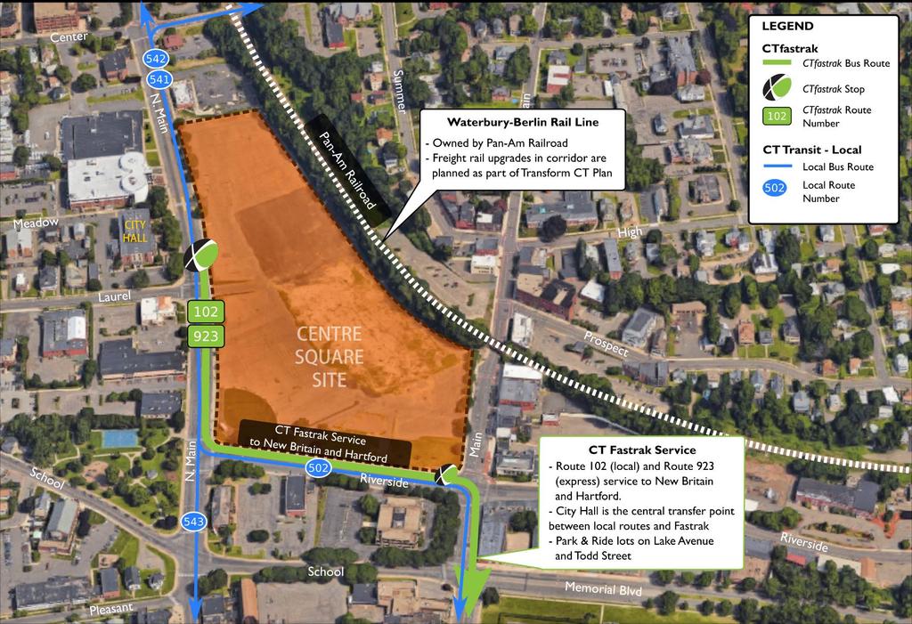

18 Transportation: Bus and Rail 18


19 Transportation: Takeaways Low traffic volumes on Main Street and North Main Street compared to other commercial corridors in Bristol (Route 6, Route 229) contribute to retail market challenges Road network does not naturally funnel traffic into Downtown many vehicles bypass downtown altogether. Excess lane capacity relative to traffic volume in several locations (Riverside Ave, North Main Street south of Center) excess road space should be repurposed (street parking, bike lanes, plaza space, etc.) Opportunity to connect North Main Street and Main Street streetscape designs through the site CTFastrak service provides good connections to Hartford and New Britain labor markets potential benefit for employers looking to relocate to site. However, bus service remains limited in the remainder of Bristol Bristol is a driving city ample and conveniently located parking is crucial to the successful redevelopment of the site. Ample parking based on today s needs future parking demand will be assessed later in the study. 19

20 Ongoing Projects Route 6 Study Route 69/72 Intersection Improvements Bristol Hospital Memorial Boulevard Bike Lanes MBS Theater Project 20

21 Public Outreach 21


22 Preliminary Survey Results Good range of age groups need to bolster numbers in under 35 groups About half of respondents have lived in Bristol their whole live 22

23 Preliminary Survey Results: Density The Right Density: 73.4% Too Dense: 54.9% Not Dense Enough: 85.1% 23

24 Preliminary Survey Results: Design Least Favorite Designs 23.2% Favorite 10.6% Favorite 4.4% Favorite 31.5% Favorite 32.2% Favorite Favorite Designs 24

25 Opportunities Create a programmatic destination while development occurs organically- phased development approach with non-developed parcel(s) open for public passive recreational opportunities Road diets on perimeter streets improve access and/ or create on-street parking opportunities Buildings placed on the elevated portion of the site afford great views of surrounding hillsides Because of the existing utilities along North Main Street, siting the buildings back into the site increases pedestrian space along the roadway, creating wide greenspace opportunities not normally seen in downtown areas Diversity of adjacent land uses could encourage different development options (ie. lunches for employees and dinner/ shopping for residential neighbors) Encourage users of CTFastrak and local busses to use the site consider an on-site transit amenities 25

26 Constraints Rental Vacancy Rate of 14.5% and low rents limit the potential for new residential development Low critical mass to support new retail and service establishments. Challenging demographics to draw in national and regional retailers. Activity generators in Bristol are disconnected from the Downtown. Local transportation system fails to naturally funnel vehicles into the downtown. 26
27 Next Steps Second Community Engagement Event on Saturday, August 20 th from 10 AM to 12:30 PM at the West End Summer Festival Continue survey through West End Summer Festival Site layout concepts continue to seek public input and refine Preliminary design of site infrastructure (roads, streetscapes, etc.) Formal Public Workshop in late-september 27

28 Questions? 28
Transportation. Strategies for Action
 Transportation A major priority for the Overlake Neighborhood is to develop a multimodal transportation system. To achieve this system, a balance has to be found among travel, circulation and access needs;
City of Farmington. Downtown Plan. Amendment to the 1998 Master Plan Adopted October 11, 2004
 City of Farmington Amendment to the 1998 Master Plan Adopted October 11, 2004 Introduction Planning Background 1 Scope and Components of the Plan Amendment 2 Concept Introduction 3 Plan Concepts 3 Conceptual
Study Area. Capitol Way. Greening America s Capitals 11/13/2014. A Greening America s Capitals Project
 Olympia, WA: Greening Capitol Way Supporting Communities move towards sustainability is a priority for the federal government. A Greening America s Capitals Project Office of Sustainable Communities U.S.
The transportation system in a community is an
 7 TRANSPORTATION The transportation system in a community is an important factor contributing to the quality of life of the residents. Without a sound transportation system to bring both goods and patrons
DOWNTOWN GEORGETOWN PLANNING STUDY
 DOWNTOWN GEORGETOWN PLANNING STUDY Community Workshop #3 Thursday, May 4, 08 The Planning Partnership OVERVIEW OF STUDY, PROCESS & MILESTONES We are here PURPOSE OF THE STUDY To develop a clear vision
Ten Mile Creek Planning Area
 PLANNING AREA POLICIES TEN MILE CREEK Ten Mile Creek Planning Area Location and Context The Ten Mile Creek Planning Area ( Ten Mile Creek area ) is located south of the current Boise AOCI, generally south
DRAFT. October Wheaton. Design Guidelines
 October 2011 DRAFT Wheaton Design Guidelines 2 Draft - Design Guidelines - Wheaton Sector Plan Contents 04 Section 1: Introduction 06 Section 2: Context 08 Section 3: Design Guidelines 09 Goal 1: Create
Atlanta BeltLine Subarea 3 Master Plan Update
 Atlanta BeltLine Subarea 3 Master Plan Update April 14, 2018 Workshop Meeting 1 22 miles, connecting 45 neighborhoods 22 MILES of transit 46 MILES of streetscapes and complete streets 33 MILES of urban
This Review Is Divided Into Two Phases:
 Semiahmoo Town Centre Review The purpose of this review: To review the Semiahmoo Town Centre Concept Plan, originally approved in 1993, to ensure that this centre will continue to serve the needs of South
2035 General Plan Update and Belmont Village Specific Plan. Joint Study Session with the City Council and Planning Commission April 12, 2016
 2035 General Plan Update and Belmont Village Specific Plan Joint Study with the City Council and Planning Commission April 12, 2016 Agenda 1. Welcome and Introductions 2. General Plan Update Status of
Potential Green Infrastructure Strategies May 6, 2015 Workshop
 Potential Green Infrastructure Strategies May 6, 2015 Workshop Background The City of Cortland is developing the Tioughnioga Urban Headwaters Green Infrastructure Action Plan with funding from the National
Committee Meeting: Downtown Today & Concept Refinement September 11, 2017
 Committee Meeting: Downtown Today & Concept Refinement September 11, 2017 AGENDA 1. Brief Input Update 2. Comprehensive Plan Principles 3. Downtown Today 4. Concept Updates 5. Future Schedule What is a
Gold Line Bus Rapid Transit Transit Oriented Development (BRTOD) Helmo Station Area Plan
 Helmo Station Area Plan") Appendix F Gold Line Bus Rapid Transit Transit Oriented Development (BRTOD) Helmo Station Area Plan Introduction and Purpose of the Plan The Gold Line Bus Rapid Transit facility is an eleven-mile dedicated
Appendix F Gold Line Bus Rapid Transit Transit Oriented Development (BRTOD) Helmo Station Area Plan Introduction and Purpose of the Plan The Gold Line Bus Rapid Transit facility is an eleven-mile dedicated
Century Highfield Sub Area Plan
 Century Highfield Sub Area Plan The Century Highfield Sub Area Plan provides an opportunity to re evaluate the vision that was set forth for this area when the Township conducted a similar planning exercise
International Blvd. TOD Plan Public Workshop #1
 International Blvd. TOD Plan Public Workshop #1 Add photos or project images September 21 and 22, 2010 Workshop Purpose Introduce the public to the Project Review and discuss the existing conditions analysis
WELCOME and introduction
 1 WELCOME and introduction Mobility Hub Locations within Burlington STUDY OVERVIEW STUDY OBJECTIVES The City of Burlington is developing four Area Specific Plans, one for each of Burlington s Mobility
Mix of Uses Guide for Transit-Oriented Development MIX OF USES
 MIX OF USES Creating a Destination Magnet A diversity of uses such as retail, housing, offices, civic and entertainment within the TOD creates a destination magnet for transit users and TOD neighbors.
Ivywild On The Creek PRELIMINARY CREEK DISTRICT MASTER PLAN
 Ivywild On The Creek PRELIMINARY CREEK DISTRICT MASTER PLAN Introduction: Rejuvenating an extraordinary Creekside neighborhood THE CREEKSIDE DISTRICT The Ivywild On The Creek Neighborhood District Master
Complete Streets Master Plan for Downtown New Britain CRCOG Transportation Committee Meeting Monday, December 9, 2013
 CRCOG Transportation Committee Meeting Monday, December 9, 2013 Introduction Why the Project was Initiated About Downtown New Britain Master Plan Goals Master Plan Overview Master Plan Study Areas and
Today Land & People. Northeast Nampa Gateway District. Employment. Land Use Characteristics. Demographics. Current Zoning
 Today Land & People Employment Major employers include Saint Alphonsus, the College of Western Idaho, the Auto Mall, Sorrento Lactalis and Walmart. 3,004 jobs in 2010 (COMPASS-CIM 2040 TAZ data) 4,345
9 th Street Sub Area Plan
 9 th Street Sub Area Plan In the 1990 s, when the Township prepared the last Master Plan, the 9 th Street corridor was studied as part of a larger 9 th Street Focus Area that included the West Main Street
Definitions. Average Daily Traffic Demand (ADT): The actual number or projected number of cars that pass a point in a 24-hour period.
: The actual number or projected number of cars that pass a point in a 24-hour period.") Definitions Access Management: A combination of physical techniques and transportation policies used to control the flow of traffic between roads and the surrounding lands. Alternative City Form Scenarios:
Definitions Access Management: A combination of physical techniques and transportation policies used to control the flow of traffic between roads and the surrounding lands. Alternative City Form Scenarios:
Urban Design Brief December 23, 2015 Southside Construction Group Official Plan & Zoning By-Law Amendment
 Urban Design Brief Proposed Official Plan & Zoning By-Law Amendment 3244, 3263 and 3274 Wonderland Road South Southside Group December 23, 2015 TABLE OF CONTENTS Page No. INTRODUCTION... 1 SECTION 1 LAND
Civic Center District
 Civic Center District The Civic Center district is the civic and social heart of Warrenville, containing such public buildings as the City Hall, Warrenville Public Library, Police Station, Park District
CITY OF COLWICH COMPREHENSIVE PLAN LAND USE LAND USE 1
 LAND USE LAND USE 1 WHAT YOU WILL FIND IN THIS CHAPTER: Discussion of today s conditions and tomorrow s projections Discussion of challenges and opportunities Discussion of the environmental quality goals,
Kensington Center. Public Meeting # Transit-Oriented Development, Town of Berlin, CT
 Kensington Center Public Meeting #1 10.27.16 Transit-Oriented Development, Town of Berlin, CT CivicMoxie 2016 What is Transit-Oriented Development Definition: Transit-Oriented Development (TOD) = is an
Don Mills Crossing Study and Celestica Lands Development Application Community Meeting, Open House, and Breakout Discussions
 Consultation Summary Don Mills Crossing Study and Celestica Lands Development Application Community Meeting, Open House, and Breakout Discussions This report is not intended to provide a verbatim transcript
Building Great Neighbourhoods. Strathcona
 Building Great Neighbourhoods Strathcona March 21, 2018 Becky Redford Project Manager, Planning & Design Building Great Neighbourhoods Integrated Infrastructure Services Welcome and Purpose To provide
Stakeholders Advisory Working Groups (SAWGs) Smart Growth and TOD Land Use (#11) SAWG Meeting
 Smart Growth and TOD Land Use (#11) SAWG Meeting") Presentation - Part II Tappan Zee Bridge/I-287 Corridor Project July 21, 2010 Slide 1. David Kooris (Regional Plan Association) welcomed members of the Land Use Stakeholders Advisory Working Groups (SAWGs)
Presentation - Part II Tappan Zee Bridge/I-287 Corridor Project July 21, 2010 Slide 1. David Kooris (Regional Plan Association) welcomed members of the Land Use Stakeholders Advisory Working Groups (SAWGs)
Issues, Challenges & Opportunities
 Below is a summary of issues, challenges, and opportunities relating to the revitalization of Downtown Romeoville and potential development of the Village s East Side TOD Area. Current Issues & Challenges
THE 355/270 CORRIDOR:
 THE 355/270 CORRIDOR: Strategic Ideas for Sustaining a Livable Work Place Project Summary ACCESS LIFE DESIGN HEALTH WORK Montgomery County Planning Department The Maryland-National Capital Park and Planning
Urban Design Brief Fanshawe Park Road. Competition Toyota
 Urban Design Brief 1300 Fanshawe Park Road Competition Toyota May 2, 2014 TABLE OF CONTENTS Page No. INTRODUCTION... 1 SECTION 1 LAND USE PLANNING CONTEXT... 1 1.1 The Subject Lands... 1 1.2 The Proposal...
LEED-ND 101: Practical Strategies for Achieving Sustainability Goals. Travis Parker Lakewood Planning Director
 LEED-ND 101: Practical Strategies for Achieving Sustainability Goals Travis Parker Lakewood Planning Director Metro Vision Idea Exchange Oct 11, 2012 West Corridor Stations West Corridor Overview West
Allen Street Civic District Redevelopment Area Plan Redevelopment Plan & Proposal State College Planning Commission State College Redevelopment
 Allen Street Civic District Redevelopment Area Plan Redevelopment Plan & Proposal State College Planning Commission State College Redevelopment Authority September 17, 2015 Discussion Points Overview of
A BLUEPRINT FOR BROCKTON A CITY-WIDE COMPREHENSIVE PLAN
 A BLUEPRINT FOR BROCKTON A CITY-WIDE COMPREHENSIVE PLAN Public Meeting October 2016 1 Plan Summary and Discussion Public Meeting May 4 2017 City of Brockton Bill Carpenter, Mayor Department of Planning
Courthouse Square Planning & Urban Design Study Working Group Meeting #11 September 2, 2014
 Courthouse Square Planning & Urban Design Study Working Group Meeting #11 September 2, 2014 1 Study Area Courthouse Square DRAFT Design Concepts A B C 3 Public Feedback July 23 Workshop & Online Survey
Cleveland Park Streetscape and Drainage Improvement Project 1
 Cleveland Park Streetscape and Drainage Improvement Project 1 Urban Context Washington, D.C. Connecticut Avenue Cleveland Park Streetscape and Drainage Improvement Project 2 Neighborhood Context Contributing
I-84 Hartford Project Open Planning Studio #12. April 25, 2017
 I-84 Hartford Project Open Planning Studio #12 April 25, 2017 Meeting Agenda 1. I-84 Hartford Project alternatives update 2. Multimodal station area planning 3. I-84 / I-91 Interchange Study coordination
THE NEIGHBORHOOD TODAY
 THE NEIGHBORHOOD TODAY CORE AREA VISION How are we Good Urbanism A Site s DNA thinking about Elements of great Unique elements urban communities embedded in a place the site and design? ELEMENTS LIKE:
Commercial Node Plan Devine Street/Jackson Blvd. COLUMBIA, SC
 Commercial Node Plan Devine Street/Jackson Blvd. COLUMBIA, SC 9.17.13 AGENDA 1 Introductions 2 Project Update 3 Concepts 4 Recommendations 5 Next Steps Introductions Project Update Process 5-Phase Process
Community Design Guidelines. Port Wallace DRAFT
 Community Design Guidelines Port Wallace DRAFT Energy 1 2 3 Nature Movement Connections Built Form DRAFT Layout Energy 1 Nature Community Design Guidelines GREAT COMMUNITIES PROTECT, CELEBRATE, AND CONSERVE
Tyvola & Archdale Transit Station Area Plan. May 15, 2008
 Tyvola & Archdale Transit Station Area Plan First Public Meeting May 15, 2008 Presentation Outline 1. Purpose and Process 2. Station Area Overview 3. Plan Recommendations Vision Land Use Transportation
SPRINGHILL LAKE TRANSIT VILLAGE
 Greenbelt Metro Area Sector Plan - Subarea Design Policies and Guidelines - Springhill Lake Transit Village 113 SPRINGHILL LAKE TRANSIT VILLAGE Residential Neighborhood and Village Center CONCEPT Springhill
Hopkins. Development Guidelines May Overview. Sponsored by: Blake Road Corridor Collaborative City of Hopkins
 Hopkins Blake Road LRT Station Area Development Guidelines May 2015 Sponsored by: Blake Road Corridor Collaborative City of Hopkins Overview Hopkins is a dynamic community of over 17,000 residents located
C. Westerly Creek Village & The Montview Corridor
 C. Westerly Creek Village & The VISION Community Vision When the goals of the city are achieved Westerly Creek Village, a distinctive community defined by Montview Boulevard and Westerly Creek, is a strong
Establish a network of streetscaped vehicle and pedestrian routes that connect within and outside the Plan area.
 This Plan s urban design goals are to create an urban scale, walkable community with connections to transit, parks, and services and with amenities and facilities for residents and employees. The 1992
CHAPTER 5: GUIDING PRINCIPLES
 CHAPTER 5: GUIDING PRINCIPLES The following 10 principles were developed based on public consultation, planning policy and the background analysis conducted during Phase 1. The Guiding Principles significantly
Planning Districts INTRODUCTION
 INTRODUCTION To facilitate detailed examination of development prospects for all areas of the community, Delano has been divided into 14 planning districts. The location of these planning districts is
Lambeth Main Street Streetscape Improvements
 Lambeth Main Street Streetscape Improvements Open House October 5th, 2017 Agenda 1. Introduction 2. Project Background 3. Context 4. Project Objectives 5. Design Principles & Approach 6. Streetscape Design
Status Report: MD 355 Project
 Status Report: MD 355 Project OCTOBER 2006 M-NCPPC MONTGOMERY COUNTY PLANNING DEPARTMENT Summary of Community Comments, and break to the Results of the MD 355 Participation Session Brookside Gardens -
Chapter 1: Introduction
 Chapter 1: Introduction The Penn Avenue Community Works Corridor Vision and Implementation Framework presents an integrated communitybased vision and a coordinated, long-term implementation framework for
DRAFT Concept Alternatives
 O c t o b e r 2016 DRAFT Concept Alternatives W a l n u t G e n e r a l P l a n U p d a t e a n d W e s t Va l l e y S p e c i f i c P l a n Contents WHAT IS THE GENERAL PLAN..........................................
Preliminary Recommendations Tk Takoma/Langley Crossroads Sector Plan
 Preliminary Recommendations Tk Takoma/Langley Crossroads Sector Plan Vision is to achieve a Transit Oriented, pedestrian friendly Community that Celebrates and builds upon the cultural Diversity of the
OPEN HOUSE. Future. Neighborhood. Thursday April 27, :30 8:30 PM Refreshments provided Discovery Center, 4444 Hadley Avenue North
 OPEN HOUSE Thursday April 27, 2017 6:30 8:30 PM Refreshments provided Discovery Center, 4444 Hadley Avenue North The City Council has ini ated a planning process to guide future development on 206 acres
City of Bristol Route 6 Corridor Implementation Program
 City of Bristol Route 6 Corridor Implementation Program FITZGERALD & HALLIDAY, INC. Innovative Planning, Better Communities June 2017 Route 6 Corridor Plan IMPLEMENTATION PROGRAM The following Implementation
Midtown Greenway Land Use and Development Plan Executive Summary
 Midtown Greenway Land Use and Development Plan Executive Summary Introduction The Midtown Greenway Land Use and Development Plan sets policy direction for land use and development in the Midtown Greenway
understanding Green Infrastructure In Zoning
 understanding Green Infrastructure In Zoning Purpose Measurable standards can be adopted within municipal zoning codes, and subdivision and stormwater regulations, to promote a comprehensive approach to
New Partners for Smart Growth Conference February 5, 2010
 Dan Stroh, Planning Director City of Bellevue Planning and Community Development Bellevue, WA New Partners for Smart Growth Conference February 5, 2010 Summary of Project Long-range plan update for Bel-Red
Executive Summary. NY 7 / NY 2 Corridor
 Executive Summary NY 7 / NY 2 Corridor Transportation and Land Use Study December 2005 Prepared for: Town of Colonie Capital District Transportation Committee Prepared by: Introduction: Land use decisions
The West Vaughan Employment Area Secondary Plan Policies
 Part 2: The West Vaughan Employment Area Secondary Plan Policies 2.1 General Policies It is the policy of Council: 2.1.1. That the West Vaughan Employment Area (the WVEA), identified on Schedule 1, will
Toronto Complete Streets Guidelines
 Toronto Complete Streets Guidelines 108 110 7.1 Green Infrastructure Design Principles 112 7.2 Context-Sensitive Green Streets 114 7.3 Key Green Street Elements Green infrastructure refers to natural and
DRAFT ROOSEVELT ROAD. District Recommendations. Figure 5.23 The Roosevelt Road Corridor
 CHAPTER 5 Figure 5.23 The Road Corridor Road will develop as a mixed-use corridor, emphasizing regional retail, west of the river and mixed-use development east of the river. KEY RECOMMENDATIONS 1. High
Town Center (part of the Comprehensive Plan)
") Town Center (part of the Comprehensive Plan) Mercer Island Town Center Looking North (2014) In 1994, a year-long process culminated in a set of design guidelines and code requirements for the Town Center
Town Center (part of the Comprehensive Plan) Mercer Island Town Center Looking North (2014) In 1994, a year-long process culminated in a set of design guidelines and code requirements for the Town Center
PLAN ELEMENTS WORKSHOP. April 5, 2016
 PLAN ELEMENTS WORKSHOP April 5, 2016 needs more housing. But there is no one-size fits-all solution. Every neighborhood has its own character. In some places, density is not only appropriate it is badly
hermitage town center
 hermitage town center A Community Vision prepared by Strada for The City of Hermitage and The Mercer County Regional Planning Commission January 2007 table of contents introduction 3 design principles
City of Ennis. Downtown Master Plan Catalyst Projects
 City of Ennis Downtown Master Plan Catalyst Projects Revised Framework Plan REVISED Project Types and Descriptions Project Types A. Visitor Attracting Projects: Projects in this category are intended to
ANCHOR TO ANCHOR. Rescale the street to create an iconic boulevard.
 ANCHOR TO ANCHOR Rescale the street to create an iconic boulevard. UR NE ER UV GO NE LA OBJECTIVES 1. Maintain appropriate traffic flow and prioritize commercial curb access 2. Mark gateways at the street
General Location Annex, Rezone & Preliminary Plat Lansdowne Addition, Unit Three
 NEWFOUNDLAND I-5 Agricultural District Subject Site SUNDANCE ANDERSON Single Family Residential CHRISTY PUD Agricultural District Highway Business General Location Annex, Rezone & Preliminary Plat Lansdowne
REGIONAL ACTIVITY CENTER
 DRAFT REGIONAL ACTIVITY CENTER 70 EAST BENCH MASTER PLAN DRAFT 06 Introduction The East Bench Regional Activity center is comprised of large educational, research, medical, and employment centers. These
Access Management: An Overview
 Figures 1-5 Below Evolution of development along a highway. In the early stages, land along the road is used for farming with little traffic generated. As time passes, the highway corridor becomes a de
Drexel, Barrell & Co.
 Drexel, Barrell & Co. June 18, 2018 Engineers/Surveyors Boulder Colorado Springs Greeley 3 South 7 th Street Colorado Springs, Colorado 80905-1501 719 260-0887 719 260-8352 Fax El Paso County Planning
MONTGOMERY COUNTY PLANNING DEPARTMENT THE MARYLAND-NATIONAL CAPITAL PARK AND PLANNING COMMISSION
 MONTGOMERY COUNTY PLANNING DEPARTMENT THE MARYLAND-NATIONAL CAPITAL PARK AND PLANNING COMMISSION MCPB Item No. Date: 12-10-15 Leisure World Clubhouse II Addition Fitness Center, Limited Site Plan Amendment
 Health Sciences City The available land area, although limited, combined with the unique partnership between the primary institutions and the supporting partnerships of the development interests within
Metro. Activity Center Design Guidelines. Recommendations For Developing Focused, Mixed-Use Commercial/Residential Centers
 Metro Activity Center Design Guidelines Recommendations For Developing Focused, Mixed-Use Commercial/Residential Centers Metro Activity Centers What is a MAC? Legacy, the adopted guide for the future growth
Developer s Program. The Station at East 54
 Developer s Program The Station at East 54 Existing Conditions The Station at East 54 is proposed for a 1.12 acre site at the northeast corner of Hamilton Road and Prestwick Road, tucked between the East
Former Rockcliffe Airbase Community Design Plan Guiding Design Vision and Principles December 4, 2013
 APPENDIX 5 - Guiding Design Vision and Principles Former Rockcliffe Airbase Community Design Plan Guiding Design Vision and Principles December 4, 2013 Vision Statement The redevelopment of the former
Urban Planning and Land Use
 Urban Planning and Land Use 701 North 7 th Street, Room 423 Phone: (913) 573-5750 Kansas City, Kansas 66101 Fax: (913) 573-5796 Email: planninginfo@wycokck.org www.wycokck.org/planning To: From: City Planning
EXISTING COMPREHENSIVE PLAN
 EXISTING COMPREHENSIVE PLAN Town Center Land Use Element: V. LAND USE POLICIES Town Center Mercer Island's business district vision as described in "Your Mercer Island Citizen-Designed Downtown" was an
CITY OF PUYALLUP. Background. Development Services
 CITY OF PUYALLUP Development Services 333 South Meridian Puyallup WA 98371 To: City Council From: Katie Baker, AICP, Planning Division Re: South Hill Neighborhood Plan Adoption Date: (Meeting date: February
New York Avenue Streetscape and Trail Project Public Meeting #1 Summary
 New York Avenue Streetscape and Trail Project Public Meeting #1 Summary I. King Jordan Student Academic Center (SAC) Gallaudet University, Washington, DC February 23, 2017 Table of Contents 1.0 Introduction...
FUNDING CORRIDOR REVITALIZATION
 FUNDING CORRIDOR REVITALIZATION Integrated corridor planning for the 21 st Century America Planning Association Annual Conference Atlanta, GA April 27, 2014 Mariia Zimmerman, MZ Strategies, LLC mariia@mzstrategies.com
John M. Fleming Managing Director, Planning and City Planner. Old East Village Dundas Street Corridor Secondary Plan Draft Terms of Reference
 Report to Planning and Environment Committee To: From: Subject: Chair and Members Planning & Environment Committee John M. Fleming Managing Director, Planning and City Planner Old East Village Dundas Street
GPA FALL 2017 CONFERENCE
 Change in Doraville Doraville at the beginning of a new era Design Doraville (Comp. Plan) adopted in 2016 Doraville Town Center Masterplan LCI (2005) Downtown Doraville Masterplan LCI (2010) 2014 Adoption
Public Meeting May 20, 2014
 Public Meeting May 20, 2014 Overview Study Purpose Study Area Overview Strategies Potential Opportunities Implementation and Discussion Skeo Solutions Raleigh Walkable Watershed Pilot 2 Purpose Develop
Fifth and Detroit Street Design May 2017 Capital Improvements Committee. DOWNTOWN Street Design
 1 Fifth and Detroit Street Design May 2017 Capital Improvements Committee Agenda 2 Review Street Configuration Prior Meeting Review Outreach Synopsis Functional Street Design Refinements Curb Edge, Turning
Chapter 5: Natural Resources and Environment
 NATURAL RESOURCES AND ENVIRONMENT 5-1 5 Chapter 5: Natural Resources and Environment BACKGROUND AND INTENT Urban expansion represents the greatest risk for the future degradation of existing natural areas,
Sahuarita District & Phase 1 Master Plan. Town Council December 11, 2017
 Sahuarita District & Phase 1 Master Plan Town Council December 11, 2017 Visioning Study Visioning Process Advisory Group Meetings Community Questionnaire Town Center Case Studies Community Analysis The
OVERVIEW OF PLANS FOR THE JEFFERSON COUNTY COUNTRYSIDE FARM In the Context of Quality Place Characteristics
 OVERVIEW OF PLANS FOR THE JEFFERSON COUNTY COUNTRYSIDE FARM In the Context of Quality Place Characteristics By Steve Grabow, Professor and Community Development Educator University of Wisconsin-Extension,
FRUITVALE TRANSIT VILLAGE (Phase 2) Residential Project
 Residential Project") FRUITVALE TRANSIT VILLAGE (Phase 2) Residential Project DEVELOPER: SIGNATURE PROPERTIES ARCHITECT: HKIT ARCHITECTS April 23, 2010 TABLE OF CONTENTS 3 Vision 4 Description of Site 5 Guiding Concepts 6
FRUITVALE TRANSIT VILLAGE (Phase 2) Residential Project DEVELOPER: SIGNATURE PROPERTIES ARCHITECT: HKIT ARCHITECTS April 23, 2010 TABLE OF CONTENTS 3 Vision 4 Description of Site 5 Guiding Concepts 6
Downtown North Las Vegas Demonstration Site Project. Project Update
 Downtown North Las Vegas Demonstration Site Project Project Update 7.16.14 Presentation Overview Project Purpose and Process Planning Context Opportunities and Barriers Summary Community Input Preliminary
Beaverton City Council: Work Session. SIDEDistrict. May 6, 2014
 BEAVERTON Beaverton City Council: CREEK Work Session SIDEDistrict May 6, 2014 Tonight s Agenda BEAVERTON CREEK SIDE Brief updates Creekside Vision Scenarios & discussion: Redevelopment & Parking Project
The Vision. Photo provided by The Minervini Group. 46 Vision, Objectives & Strategies
 Vision, Objectives & Strategies The is the public framework and guide for future development of the Grand Traverse Commons. The establishes public polices for infrastructure, the preservation of natural
Description of Preferred Alternative
 Chapter 2 Description of Preferred Alternative 2.1 Introduction This chapter of the programmatic Sammamish Town Center Sub-area Plan Final EIS provides a more detailed description of the Preferred Alternative
Hockessin Community Redevelopment Plan
 Hockessin Community Redevelopment Plan 3.1 Introduction The Community Redevelopment Plan for the Village of Hockessin is the result of the people s vision for a distinct village center that serves as the
URBAN DESIGN BRIEF URBAN DESIGN BRIEF 721 FRANKLIN BLVD, CAMBRIDGE August 2018
 URBAN DESIGN BRIEF URBAN DESIGN BRIEF 721 FRANKLIN BLVD, CAMBRIDGE August 2018 DESIGN BRIEF CONTENTS PART A 1.0 INTRODUCTION 2.0 DESCRIPTION & ANALYSIS OF SITE CONTEXT 3.0 DESIGN CONSTRAINTS AND OPPORTUNITIES
IMAGINE CLEARWATER. Community Workshop 3. November 2016
 IMAGINE CLEARWATER Community Workshop 3 November 2016 Imagine Clearwater has been a 6-month community-focused process to re-envision the downtown waterfront. VISIONING FRAMEWORK MASTER PLAN HOW CAN WE
Public input has been an important part of the plan development process.
 Lakewood s Comprehensive Plan recognizes that transportation helps shape the community, and that the way the community provides for the safe and efficient movement of people affects the character of the
INDEPENDENCE BOULEVARD AREA PLAN
 INDEPENDENCE BOULEVARD AREA PLAN Public Meeting October 28, 2008 Tonight s Agenda Introduction 4:00 4:05 Tom Warshauer Presentation 4:05 5:00 Blake Drury Group Exercises 5:00 5:50 All Wrap Up & Next Steps
The University District envisions, in its neighborhood
 Envisioning the University District Link Light Rail in Seattle s neighborhoods CIY OF SEALE CONCEP-LEVEL SAION AREA PLANNING RECOMMENDAION RESOLUION # 30165 EXHIBI L Vision 08.2000 he University District
Town of New Scotland. Public Workshop. Visioning / Planning the Future of this Hamlet. New Scotland Hamlet Master Plan.
 Public Workshop Visioning / Planning the Future of this Hamlet December 1, 2011 Voorheesville High School Commons Agenda I. Presentation Project Introduction The Study Area Existing Conditions Outcomes