Multi-family Residential: 164, ,000 Sq. Ft. (approx. 172 Units) Single-family Residential 21 Units
|
|
|
- Ashlee Ford
- 6 years ago
- Views:
Transcription

 BUILD-OUT")


 Single-family Residential 21 Units Multi-family Residential:")
 Single-family Residential 21 Units BASE BUILD-OUT ESTIMATES:")
 Multi-family Residential: 1,176,000-1,362,000 Sq. Ft.")
 BASE BUILD-OUT ESTIMATES: Multi-family Residential: 422,000-490,000")
 BASE BUILD-OUT ESTIMATES: Multi-family Residential:")
 BONUS BUILD-OUT")
1 Welcome to the Washington/Kirkwood Study Area, Scope, Special Existing GLUP Conditions Study Plus WELCOME! (Not advanced for further study beyond the December 2016 LRPC meeting) (Not advanced for further study beyond the December 2016 LRPC meeting) BUILD-OUT ESTIMATES: Retail: 169,000 Sq. Ft. Multi-family Residential: 207,000 Sq. Ft. ( Units) Single-family Residential 21 Units BASE BUILD-OUT ESTIMATES: BONUS BUILD-OUT ESTIMATES: Multi-family Residential: 164, ,000 Sq. Ft. (approx. 172 Units) Single-family Residential 21 Units Multi-family Residential: 280, ,000 Sq. Ft. (approx. 295 Units) Single-family Residential 21 Units BASE BUILD-OUT ESTIMATES: BONUS BUILD-OUT ESTIMATES: Multi-family Residential: 741, ,000 Sq. Ft. (approx. 780 Units) Multi-family Residential: 1,176,000-1,362,000 Sq. Ft. (approx. 1,238 Units) (Not advanced for further study beyond the December 2016 LRPC meeting) BASE BUILD-OUT ESTIMATES: Multi-family Residential: 422, ,000 Sq. Ft. (approx. 445 Units) BASE BUILD-OUT ESTIMATES: Multi-family Residential: 343, ,000 Sq. Ft. (approx. 362 Units) Plus 34 Units BASE BUILD-OUT ESTIMATES: Multi-family Residential: 741, ,000 Sq. Ft. (approx. 780 Units) BONUS BUILD-OUT ESTIMATES: Multi-family Residential: 669, ,000 Sq. Ft. (approx. 705 Units) BONUS BUILD-OUT ESTIMATES: BONUS BUILD-OUT ESTIMATES: Multi-family Residential: 506, ,000 Sq. Ft. (approx. 533 Units) Plus 34 Units Multi-family Residential: 1,133,000-1,312,000 Sq. Ft. (approx. 1,192 Units)


2 Study Area and Scope APPLICATIONS In June 2016, Eleventh Street Development, LLC submitted to the Arlington GLUP Amendment Application Subject Sites Washington Kirkwood GLUP+ Study Area and Ownership Study Timeline the study


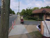
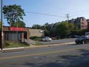
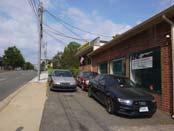
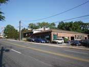


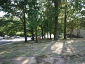
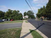
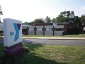
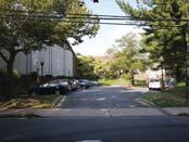
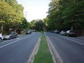
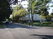
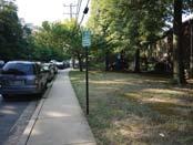
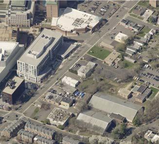
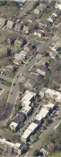


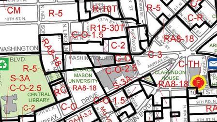
3 N KIRKWOOD RD Existing Conditions Topography Washington Kirkwood GLUP+ Study Aerial Bird s Eye (2015) Tree Canopy Coverage Current GLUP (General Land Use Plan) Site Assemblage Assumptions (for modeling) Study Area TH ST N 8 6 WILSON BLVD WASHINGTON BLVD FAIRFAX DR WILSON BLVD LEGEND N Open Space/Parks 6-8 Note: Building Heights are approximate measured in stories above grade Current Zoning Area Building Heights Study Area Photographs

.")
4 Form and Massing Models LRPC Meeting #5 Form and Massing Models In LRPC #3 and #4 meetings, participants commented on several occasions about the direct effects that assumptions about average unit size and amount of bonus density have on the resulting massing models. In response, staff generated additional modeling based upon lesser assumptions for average residential unit size (950 gross square feet per unit, reduced from 1,100 square feet) and the percentage of bonus density reflected with each site (20% increase in density through bonus and green building incentive density, reduced from 40% increase). The form and massing models on this page represent a modified version of Scenario 5 than was presented in previous LRPC meetings. Depicted below are key revisions and notes of importance. (a) Maintains a 3-4 story height residential liner along 13th Street North, (b) Existing trees & open space are preserved to provide buffer and transition to townhomes, (c) Approximately 0.5 acre public open space at northwest corner helps transition to homes on 13th Street North and North Kansas Street, (d) Maintains a 3 to 4-story height and transition area to adjacent single family homes on 12th Road North, (e) Expands open space around the cemetery and improves access and visibility from all sides, and (f) Maintains up to 5 and 6 story heights along Washington Boulevard. f e d c b c a d e f a b f e d c b c a d e f a b


5 Form and Massing Models LRPC Meeting #5 Form and Massing Models The images below provide a more detailed view of several places within the study area where managing the placement and heights of buildings to establish deliberate transitions between new development and existing buildings or landscape resources is particularly important. Building heights step down from Washington Boulevard to single-family homes to the west 0.5 acre neighborhood park helps with transition & increases green space Building heights step down from Washington Boulevard to single-family homes to the west Open spaces & streets serve as buffers Legion Site to be preserved Existing mature trees & open space serve as buffer to townhomes to the north New open space provides opportunity for more trees & green space for the community Eleventh St Development Site Legion Site Eleventh St Development Site YMCA facility is built into the existing topography & is lined with residential facing 13th Street North Character of North Kirkwood Road is maintained with median trees providing visual buffer New building anchors corner with greatest heights at low point of study area With topography, building heights are mirrored with existing townhomes on east side of North Kirkwood Road Opportunity to expand green space around cemetery to buffer from adjacent uses Improved visibility & access to cemetery from all sides Central green space framed on all sides with buildings NOTE: - For modeling purposes, the images above represent the BASE development scenario. Please refer to the cross sections for BASE and BONUS heights and resulting transitions.
 and bonus (pink) scenarios.")
6 Cross Sections LRPC Meeting #5 Cross Sections The building heights depicted in the cross sections below provide another perspective to better understand potential transitions in building height and scale based on refined modeling generated for LRPC #5. Building heights are shown for base (black) and bonus (pink) scenarios. Building heights as depicted in these section drawings are measured of off average site elevation. For this study, staff is working with existing grade, and did not regrade the site for specific potential building volumes


 and the broader community (through input from the May open house")


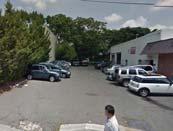
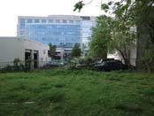
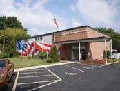
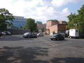
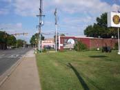
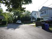
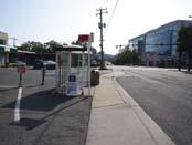
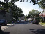
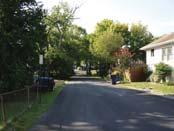
7 Guiding Principles VI. GUIDING S Earlier sections of this document use maps, illustrations and other exhibits to depict a range of potential future build out scenarios, based primarily upon computer-generated 3D form and massing models. These visual expressions are generally based on numerous ideas about what future development and public space in this area should look like and how it should function. Staff first introduced these ideas as a preliminary collection of thoughts at LRPC Meeting #3. Based on input from the LRPC (through meeting discussions and written comments) and the broader community (through input from the May open house and written comments) staff further refined these ideas, which are largely articulated in this section as a collective set of Guiding Principles. At their core, the Guiding Principles are essentially aspirational goals for the area that should be achieved through future redevelopment and improvement projects. They can equally be understood as a set of guidelines that should inform and influence future projects in the area, to most effectively advance the vision and recommendations of this Study Plus and Concept Plan. Recognizing that future development proposals and other projects will include details that invariably vary from the form and massing models and illustrative plan exhibits included herein, these Guiding Principles will play an important role in the evaluation of future projects for consistency with the goals and intent of the Study Plus and Concept Plan. 1 Evolve the area s automobileoriented development pattern into a pedestrian-oriented mixed-use place through high-quality redevelopment that contributes positively to its surroundings. Existing conditions (above) are designed for vehicular access, not walkability: numerous curb cuts, parking lots, narrow sidewalks with no separation from the street, and little to no connectivity between sites. In sharp contrast, the other images depict pedestrian-friendly development with buildings that frame attractive and inviting sidewalks, street trees, lighting and amenities, and interesting shopfronts. Carlyle St Alexandria - Washington Fine Properties Preserve and reinforce the primarily residential character of neighborhood streets west and north of the site. NH Main Street by Brett VA, licensed by CC Pershing Dr - Pictometry International 3400 Columbia Pike, elevation by Lessard Design Inc. The arrows on the aerial image below denote locations where it will be especially important to design building form and massing that transitions appropriately to the adjacent residential properties. There are detached single-family homes to the west and northwest, and townhomes to the north of the study area. The above examples show different ways in which similar transitions have been treated. The top left image shows The Zoso building in Clarendon with 5-story height and deliberate stepdown to 4-stories as it approaches adjacent single-family homes. Different strategies for step-down and transitions occur at 3400 Columbia Pike, with the multi-family building stepping down to 3-story liner (middle), and with 4-story townhouses that read as 3-stories fronting the street, with a rooftop terrace (right). Desired Transitions Pictometry International These photos, and the aerial image above, show existing conditions in and around the site, which exemplify the type of surrounding neighborhood character that should be preserved. The neighborhood consists mostly of single-family homes and duplexes, with mature trees and landscaping, and sidewalks in most places. Locate, design and sculpt new buildings to achieve deliberate and harmonious transitions between potential mid-rise, mixed-use development and adjoining single family residences. Google Maps 2


 leaves much to be desired.")


, and green streets with stormwater management strategies like permeable")


8 Guiding Principles 5 Provide the appropriate amount of parking for the density and programs associated with new development in the area (respecting the ultimate outcome of the Residential Parking Study), and strongly encourage any structured parking to be below grade. Parking garage in DC - stocktoncitylimits.com Studio Theatre - bmcproperties.com Top left: Existing pedestrian facility conditions (including along Washington Boulevard shown here) leaves much to be desired. The other photos show precedents of livelier streetscapes with retail, outdoor dining, and civic institutions framing the public realm and pedestrian space. The Penrose Square example (right) depicts how on-street parking can provide a physical buffer between pedestrians and passing vehicles, something that could apply well on Washington Boulevard. Anthony Bowen YMCA - simpsonpropertygroup.com 4 Enhance the pedestrian streetscape and experience along Washington Boulevard activating uses, including civic institutions and other neighborhood amenities and services, without exclusively requiring retail in redevelopment projects. Google Maps streetview Parking should occur mostly in underground garages or at-grade structures with entrances and facades that blend well into the rest of the building. Curb-side parallel parking could also be appropriate on some streets. Loading needs should be considered early on and should be consolidated next to garage entrances towards the interior of sites if possible. 7 Incorporate attractive and safe pedestrian circulation across the block, preserve existing stands of mature trees, support and complement indoor recreational activities, and provide opportunities to address open space needs of the surrounding neighborhoods. Additional through-block connectivity will be important for this site to improve accessibility throughout the site, and create linkages. This could occur via a combination of smaller street segments (above) or alleys, shared use streets (below), and green streets with stormwater management strategies like permeable paving (below) and bioretention planters (right). Drains by Payton Chung, licensed by CC The Altaire rendering - LCOR / Oculus / SK&I Architecture 6 Balance the creation of new streets and/or alleys to add connectivity and circulation across the block, mitigate the area s overall topography, and avoid creating excessive asphalt and impermeable surfaces at grade. Tower Grove Park - johnsonmatel.com The image to the left shows an example of public art as a landscape feature, making an interior walkway more attractive. The top image shows a small neighborhood park, that could be a precedent for the new space envisioned for the study area, and the bottom right image shows a pathway through a stand of mature trees and attractive landscaping.


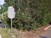
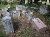
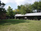
9 Guiding Principles 9 Support the modernization of important civic and community institution facilities that continue their long-established presence in the area, recognizing that this may include joint-venture redevelopment projects with outside partners. Lubber Run Community Center rendering - VMDO, Inc. Buckingham Village Arlington Oaks Condo - orangelinecondo.com 2201 N Pershing Dr rendering - rappaportco.com These developments include a mix of market rate and committed affordable housing. Ballston Row Townhomes - dccondoboutique.com The Jordan 8 Capitalize on opportunities to achieve a diverse mix of market rate and committed affordable housing units in close proximity to the Virginia Square and Clarendon Metro Station Areas. The images on the left show the existing civic institutions for which is there is general support to maintain in the study area. Above are two images of community centers in Arlington which have or are planning to redevelop along with other mixed uses. 11 Design projects that leverage the area s existing topography and organize building height and density to continue a development pattern where density and height transition down towards the low residential neighborhood in a sensible way. Existing photos of the Ball Family Burial Grounds (below) show its informal arrangement of headstones in an open grassy pipe-stem lot. The historical marker on Washington Boulevard (below left) is the only indication of the burial grounds from the public right of way, which is currently hidden from public view behind buildings and surface parking. The images above illustrate possible design treatments for the area, including better public visibility and access, and the creation of a tranquil and respectful cemetery space even in the midst of new development. Marble Hill Cemetery - Wikimedia Commons Columbia Pike Village Centre rendering - KDG Architects 10 Preserve, respect and enhance the historic integrity and site conditions of the Ball Family Burial Grounds, while improving public visibility and access to the site. Washington Vista rendering - NVR Inc. and R2L: Architects PLLC The projects shown here illustrate how a building and adjacent public spaces and pathways can integrate well and respond to the topography of their sites. Left: Penrose Square, Top: Columbia Pike Village Centre, Bottom: Washington Vista


10 Guiding Principles 13 Take effective measures to manage additional transportation demands generated by future redevelopment that do not excessively burden local residential streets. Anthony Bowen YMCA These other YMCA projects show the development potential for vertical-mixed use buildings with residential space above institutions. While only YMCAs are shown, this approach could be a possibility for the American Legion site as well. Managing transportation demands and reducing traffic is all about options. Shown here are various modes of transportation that redevelopment in the study area should take full advantage of: cycling, walking, metro, and buses. Richmond District YMCA 12 Explore how vertically mixing residential space above institutional uses can most efficiently use limited available space while providing benefits that come Coney Island YMCA with co-location. 15 Design all sides of buildings thoughtfully so that they enhance the pedestrian experience while still accommodating parking and loading access points where needed. Shown above is what can happen when parcel consolidation does not occur - out parcels that can be out of scale and context with redevelopment. To the right and below show examples of possible parcel assemblages for the study area, though there are numerous ways in which these properties may or may not consolidate Pershing Dr., Arlington, VA Gaslight Square, Arlington, VA The design of building facades that border open spaces, pedestrian connections, or the public realm should be interesting and contribute towards creating active outdoor spaces. Buildings primary orientation should be towards the street and/ or public spaces. Windows, balconies, and patios of units should be oriented to face the street or public spaces providing an added sense of security and eyes on the street. 14 Encourage consolidation of smaller parcels with redevelopment when doing so would more effectively advance desired urban design principles and provide for better coordinated development in the area. Flats at Atlas, Washington D.C.

11 Circulation and Public Space Concept Map PRESERVE EXISTING TREES INTERSECTION IMPROVEMENTS OPEN SPACE VEHICULAR ACCESS PED/BIKE CONNECTION FROM CEMETERY TO 13TH ST N MAINTAIN & ENHANCE CHARACTER OF N KIRKWOOD RD PED/BIKE CONNECTION INTERSECTION IMPROVEMENTS PED/BIKE CONNECTION BALL FAMILY BURIAL VEHICULAR GROUNDS ACCESS PED/BIKE CONNECTION FROM WASHINGTON BLVD TO CEMETERY STRENGTHEN PED/BIKE CONNECTION TO GMU CAMPUS & VA SQUARE METRO STATION VEHICULAR ACCESS VEHICULAR ACCESS VEHICULAR ACCESS OPPORTUNITY TO EXPAND OPEN SPACE & PROVIDE BETTER ACCESS TO CEMETERY INTERSECTION IMPROVEMENTS Note: The map depicted here site plan approval with the spaces and trees.


 12th St. N.")
 N. Quinn St.")


12 Circulation and Public Space Precedent Images The following images illustrate a variety of street and open space examples that could inform planning and design decisions associated with potential future redevelopment projects in the study area. Open Space Streets 9th St. N. between N. Lincoln St. & N. Kansas St. (approx. 55 right-of-way) 12th St. N. between N. Fillmore St. & (approx. 40 right-of-way) N. Quinn St. between Wilson Blvd. & Clarendon Blvd. (approx. 50 right-of-way) Shared Street- Seattle, WA Shared Street- Batavia, IL Shared Street- Madison, WI Shared Street- Portland, OR Gramercy Park, New York, NY Cobble Hill Park, Brooklyn, NY Rocky Run Park, Arlington, VA

13 Building Height and Form Concept Map Building Height Maximums zones depicted on this map are

14 Land Use Concept Map Upper Floor Land Use Retail or Retail Equivalents on Ground Floor (See Note 2) Open Space Open Spaces (See Note 3) Notes: 1. Ball Family Burial Grounds 2. Plan, retail equivalents may include uses that have similar uses. 3. spaces, the area depicted on the

15 Recommendations Related to the Comprehensive Plan - GLUP VIII. RECOMMENDATIONS RELATED TO THE COMPREHENSIVE PLAN To support the future implementation of the aforementioned guiding principles and concept plan recommendations, several amendments are proposed for elements of the Arlington elements as outlined below will help ensure that future private development and infrastructure investments are consistent and compatible with the vision of this plan. General Land Use Plan Recommendations County, and establishes the overall character, extent and location of various land uses. As previously mentioned, the primary impetus for this study was the submission of three individual evaluated as to the degree in which individual site plan projects advance and achieve the County s planning principles and goals for this area. Proposed Near-Term GLUP Amendments Washington Boulevard and Kirkwood Road Special GLUP Study Plus and Concept Plan as a guiding document that further articulates the County s adopted future vision for this area; and Public. Prospective Future GLUP Amendments 3. Properties primarily fronting Washington Boulevard east of the intersection with Founders Way and south of an imaginary line extending eastward from 12th Road North could be designation; 4. Properties fronting Washington Boulevard west of the intersection with Founders Way could 5. The YMCA property primarily fronting 13th Street North located north of an imaginary line extending eastward from 12th Road North could be considered for future re-designation to the or institutional activities). Exhibit 9. General Land Use Plan Recommendations

16 Recommendations Related to the Comprehensive Plan - Transportation Master Transportation Plan Recommendations The Master Transportation Plan (MTP) promotes effective travel and accessibility for the County s residents, workers and visitors; provides a policy framework to guide the development of projects and programs; advances the County s goals and objectives; and helps direct infrastructure investment. Exhibit 10. Master Transportation Plan Recommendations transportation and other planning related recommendations of the Washington Boulevard and Kirkwood Road Special GLUP Study and Concept Plan. The County anticipates future changes within the designated study area, that will include the construction of new local streets. Master Transportation Plan Amendments Streets, Washington Boulevard & Kirkwood Road Area; and 2. Amend the MTP Map to redesignate the segment of Washington Boulevard between North Lincoln Street and Kirkwood Road from a Type D Arterial Street ( Primarily Garden development process for future site plan applications and as more detailed analysis of the existing conditions and proposed development occurs. As physical changes are approved as part of site plan redevelopment projects for parcels within the study area, as proposed for addition to the County s inventory. This approach is consistent with other Areas Designated for New Streets following adoption of new sector or area plans. Development of new streets and transportation infrastructure within the study area should be consistent with the County s MTP policies.
ATTACHMENT. To the west, north, and east of the block, primarily singlefamily detached residential patterns, with some townhouses, predominate.
 COMMENT / REVISION MATRIX (as of ) for Washington and Kirkwood Special GLUP Study "Plus" and Concept Plan 1 2 Resolve inconsistency between American Legion site area noted in Map 1 1.36 AC 1.29 AC and
ARLINGTON COUNTY, VIRGINIA
 ARLINGTON COUNTY, VIRGINIA County Board Agenda Item Meeting of October 21, 2017 DATE: October 2, 2017 SUBJECTS: Request to authorize advertisement of public hearings by the Planning Commission and County
Washington Boulevard & Kirkwood Road SPECIAL GLUP STUDY PLUS and CONCEPT PLAN NOVEMBER 2017
 Washington Boulevard & Kirkwood Road SPECIAL GLUP STUDY PLUS and CONCEPT PLAN NOVEMBER 2017 Washington and Kirkwood Special GLUP Study PLUS AND CONCEPT PLAN a2 Washington Boulevard and Kirkwood Road Special
Washington Boulevard & Kirkwood Road SPECIAL GENERAL LAND U SE PLAN STU DY PLU S DRAFT JULY 21, 2017
 Washington Boulevard & Kirkwood Road SPECIAL GENERAL LAND U SE PLAN STU DY PLU S DRAFT JULY 21, 2017 Washington & Kirkwood Special GLUP Study PLUS a2 Washington Boulevard & Kirkwood Road Special GLUP Study
ARLINGTON COUNTY, VIRGINIA. County Board Agenda Item Meeting of February 23, 2019
 ARLINGTON COUNTY, VIRGINIA County Board Agenda Item Meeting of February 23, 2019 DATE: February 15, 2019 SUBJECT: Amendment to the Master Transportation Plan (MTP) Map to add a new section of North Kansas
ARLINGTON COUNTY, VIRGINIA
 ARLINGTON COUNTY, VIRGINIA County Board Agenda Item Meeting October 15, 2005 DATE: September 28, 2005 SUBJECT: Request to Advertise the adoption of the 2005 Clarendon Sector Plan C. M. RECOMMENDATION:
EXISTING COMPREHENSIVE PLAN
 EXISTING COMPREHENSIVE PLAN Town Center Land Use Element: V. LAND USE POLICIES Town Center Mercer Island's business district vision as described in "Your Mercer Island Citizen-Designed Downtown" was an
Appendix I ARLINGTON COUNTY SECTOR PLANS SUMMARY RECOMMENDATIONS RELATED TO PUBLIC SPACES
 Appendix I ARLINGTON COUNTY SECTOR PLANS SUMMARY RECOMMENDATIONS RELATED TO PUBLIC SPACES The County has developed Sector Plans for various planning areas within Arlington County s Metro corridors. Following
City of Farmington. Downtown Plan. Amendment to the 1998 Master Plan Adopted October 11, 2004
 City of Farmington Amendment to the 1998 Master Plan Adopted October 11, 2004 Introduction Planning Background 1 Scope and Components of the Plan Amendment 2 Concept Introduction 3 Plan Concepts 3 Conceptual
Policies and Code Intent Sections Related to Town Center
 Policies and Code Intent Sections Related to Town Center The Town Center Vision is scattered throughout the Comprehensive Plan, development code and the 1994 Town Center Plan. What follows are sections
S I T E P L A N R E V I E W C O M M I T T E E M E E T I N G A G E N D A
 S I T E P L A N R E V I E W C O M M I T T E E M E E T I N G A G E N D A DATE: Monday, March 11, 2019 TIME: 7:00 8:25 p.m. PLACE: 2100 Clarendon Boulevard Lobby Rooms C&D (Cherry & Dogwood) Arlington, VA
SITE PLAN REVIEW COMMITTEE MEETING AGENDA
 Page 1 SITE PLAN REVIEW COMMITTEE MEETING AGENDA DATE: Tuesday, November 13, 2018 TIME: 7:00-8:30 p.m. PLACE: Bozman Government Center, 2100 Clarendon Blvd., Room 311 Arlington, VA 22201 SPRC STAFF COORDINATOR:
ARLINGTON COUNTY, VIRGINIA
 ARLINGTON COUNTY, VIRGINIA County Board Agenda Item Meeting of April 23, 2019 DATE: April 12, 2019 SUBJECT: SP #413 SITE PLAN AMENDMENT to permit a fixed bar in a private outdoor café space with associated
40 Years of Smart Growth Arlington County s Experience with Transit Oriented Development in the Rosslyn-Ballston Metro Corridor
 40 Years of Smart Growth Arlington County s Experience with Transit Oriented Development in the Rosslyn-Ballston Metro Corridor A presentation by the Arlington County Department of Community Planning,
CRYSTAL CITY BLOCK PLAN # CCBP- G 1 DRAFT
 CRYSTAL CITY BLOCK PLAN # CCBP- G 1 DRAFT BLOCK G (Metro Market Square block) Long Range Planning Committee Meeting January 29, 2018 1 1. Introduction 2 1. LRPC Meeting Purpose Review of proposed Crystal
ARLINGTON COUNTY, VIRGINIA
 ARLINGTON COUNTY, VIRGINIA County Board Agenda Item Meeting of July 21, 2012 DATE: July 12, 2012 SUBJECT: SP #416 SITE PLAN AMENDMENT to modify condition #6 to eliminate requirement to provide a pedestrian
DRAFT. October Wheaton. Design Guidelines
 October 2011 DRAFT Wheaton Design Guidelines 2 Draft - Design Guidelines - Wheaton Sector Plan Contents 04 Section 1: Introduction 06 Section 2: Context 08 Section 3: Design Guidelines 09 Goal 1: Create
Clairtrell Area Context Plan
 Clairtrell Area Context Plan March 2005 Urban Development Services City Planning Contents 1. Introduction... 4 2. Development Structure... 6 2.1 Streets... 7 2.1.1 Sheppard Avenue and Bayview Avenue...
Town Center (part of the Comprehensive Plan)
") Town Center (part of the Comprehensive Plan) Mercer Island Town Center Looking North (2014) In 1994, a year-long process culminated in a set of design guidelines and code requirements for the Town Center
Town Center (part of the Comprehensive Plan) Mercer Island Town Center Looking North (2014) In 1994, a year-long process culminated in a set of design guidelines and code requirements for the Town Center
Establish a network of streetscaped vehicle and pedestrian routes that connect within and outside the Plan area.
 This Plan s urban design goals are to create an urban scale, walkable community with connections to transit, parks, and services and with amenities and facilities for residents and employees. The 1992
Review of Opportunity Area C Draft Comprehensive Plan and Draft BOS Follow-On Motions. Special Working Group Meeting March 4, 2015
 Review of Opportunity Area C Draft Comprehensive Plan and Draft BOS Follow-On Motions Special Working Group Meeting March 4, 2015 The slides that follow identify where the draft Comprehensive Plan has
SITE PLAN REVIEW COMMITTEE MEETING AGENDA Clarendon Boulevard Conference Room 311 Arlington, VA 22201
 SITE PLAN REVIEW COMMITTEE MEETING AGENDA DATE: Thursday, July 13, 2017 TIME: 7:00 8:30 p.m. PLACE: 2100 Clarendon Boulevard Conference Room 311 Arlington, VA 22201 SPRC STAFF COORDINATOR: TBD Item 1.
Table of Contents. Elm Avenue Improvement Plan City of Waco, Texas. Introduction 1. Existing Context 1 Figure 1 2.
 Table of Contents Introduction 1 Existing Context 1 Figure 1 2 Plan Guidelines 3 Future Urban Form 4 The West-End 4 Main Street 6 The East-End 7 Figure 2 9 Public Improvement Recommendations 7 General
NORTH QUINCY STREET P LAN ADDENDUM DRAFT:
 NORTH QUINCY STREET P LAN ADDENDUM DRAFT: 09-10-2012 a2 North Quincy Street Plan Addendum DRAFT 9-10-2012 2012 North Quincy Street Plan Addendum DRAFT TABLE OF CONTENTS PAGE I. INTRODUCTION...1 Background...1
40 Years of Smart Growth Arlington County s Experience with Transit Oriented Development in the Rosslyn-Ballston Metro Corridor
 40 Years of Smart Growth Arlington County s Experience with Transit Oriented Development in the Rosslyn-Ballston Metro Corridor A presentation by the Arlington County Department of Community Planning,
TO: FROM: SUBJECT: Background
 TO: FROM: SUBJECT: Long Range Planning Committee and Zoning Committee of the Planning Commission Kellie Brown and Margaret Rhodes, Planning Division, CPHD DATE: June 8, 2017 Courthouse Square Implementation
Courthouse Square Planning & Urban Design Study. Courthouse Square Working Group #13 October 15, 2014
 Courthouse Square Planning & Urban Design Study Courthouse Square Working Group #13 October 15, 2014 1 Courthouse Square Process Working Group Community Courthouse Square Advisory Groups & Civic Associations
ARLINGTON COUNTY, VIRGINIA
 ARLINGTON COUNTY, VIRGINIA County Board Agenda Item Meeting of March 10, 2012 DATE: February 29, 2012 SUBJECT: SP #197 SITE PLAN AMENDMENT to add a new condition #25 to allow a new use for a Yoga and Pilates
Hockessin Community Redevelopment Plan
 Hockessin Community Redevelopment Plan 3.1 Introduction The Community Redevelopment Plan for the Village of Hockessin is the result of the people s vision for a distinct village center that serves as the
ARLINGTON COUNTY, VIRGINIA
 ARLINGTON COUNTY, VIRGINIA County Board Agenda Item Meeting of April 12, 2014 DATE: April 2, 2014 SUBJECT: to the Arlington County Zoning Ordinance, Article 11.1 "CP-FBC" Columbia Pike Form Based Code
DEPARTMENT OF COMMUNITY PLANNING, HOUSING AND DEVELOPMENT Planning Division. Arlington County Planning Commission
 DEPARTMENT OF COMMUNITY PLANNING, HOUSING AND DEVELOPMENT Planning Division 2100 Clarendon Boulevard, Suite 700 Arlington, VA 22201 TEL 703.228.3525 FAX 703.228.3543 www.arlingtonva.us DRAFT TO: FROM:
Pentagon Centre (SP#297) Phase I Site Plan Amendments SPRC #3
 Phase I Site Plan Amendments SPRC #3") Pentagon Centre (SP#297) Phase I Site Plan Amendments SPRC #3 CPHD April 23, 2015 Meeting Agenda Overview of approved Phase I Site Plan Review of relevant design guidelines Presentation of current proposal
Pentagon Centre (SP#297) Phase I Site Plan Amendments SPRC #3 CPHD April 23, 2015 Meeting Agenda Overview of approved Phase I Site Plan Review of relevant design guidelines Presentation of current proposal
Courthouse Square Implementation Comment/Response Matrix
 Courthouse Square Implementation /Response Matrix 1 Are open space symbols binding? GLUP No, open space symbols are not binding, as the GLUP is a policy instrument illustrating the County s future vision
WASHINGTON/KIRKWOOD SPECIAL GLUP STUDY PLUS MAY 1, 2017 OPEN HOUSE
 1. Results of Scenario Rating Scorecard (as of May 10, 2017) WASHINGTON/KIRKWOOD SPECIAL GLUP STUDY PLUS MAY 1, 2017 OPEN HOUSE 1. Results of Scenario Rating Scorecard (as of May 10, 2017) Scenario 2 -
Civic Center District
 Civic Center District The Civic Center district is the civic and social heart of Warrenville, containing such public buildings as the City Hall, Warrenville Public Library, Police Station, Park District
PLANNING IN ARLINGTON. Briefing to Katie Cristol
 1 PLANNING IN ARLINGTON Briefing to Katie Cristol Overview 2 Comprehensive Plan - Background Administration of the Comprehensive Plan Review of the Comprehensive Plan Implementation of the Comprehensive
GUIDING PRINCIPLES IN THIS CHAPTER
 GUIDING PRINCIPLES The guiding principles and design concepts in this chapter work together with the Chapel Hill 2020 Comprehensive Plan to support new public places that can be enjoyed by all while also
Official Plan Review: Draft Built Form Policies
 PG.30.1 REPORT FOR ACTION Official Plan Review: Draft Built Form Policies Date: May 15, 2018 To: Planning and Growth Management Committee From: Chief Planner and Executive Director, City Planning Division
ARTICLE 6: Special and Planned Development Districts
 ARTICLE 6: Special and Planned Development Districts 6-10 Traditional Neighborhood Development (TND) District 6-10.10 Purpose and Intent The Traditional Neighborhood Development (TND) District provides
PUBLIC PARKS AND FACILITIES, SERVING NEIGHBORHOOD RECREATIONAL AND COMMUNITY EVENTS BUILDINGS BUILT TO THE LINE AND ORIENTED TOWARD THE STREET
 BUILDINGS BUILT TO THE LINE AND ORIENTED TOWARD THE STREET PUBLIC PARKS AND FACILITIES, SERVING NEIGHBORHOOD RECREATIONAL AND COMMUNITY EVENTS CONNECTED & COMPLETE STREETS AND STREET GRID VIEW SHEDS GROUND
Appendix C: Interim Mixed-Use Evaluation Criteria
 Appendix C: Interim Mixed-Use Evaluation Criteria C-1 Appendix C: Interim Mixed-Use Evaluation Criteria PURPOSE: The implementation of numerous policies contained within the Master Plan hinges on the creation
SECTION TWO: Urban Design Concepts
 SECTION TWO: Urban Design Concepts The Gardnerville Plan for Prosperity shapes economic opportunities presented by regional growth. The Urban Design Concepts provide policies and concepts for land use,
WEST LOOP DESIGN GUIDELINES CHECKLIST
 WEST LOOP DESIGN GUIDELINES CHECKLIST Section 1.0 General Strategies 1.1 DESIGN EXCELLENCE: ENCOURAGE HIGH QUALITY AND INNOVATIVE DESIGN OF NEW BUILDINGS WITHIN THE WEST LOOP WITHOUT BEING PRESCRIPTIVE
Lehigh Acres Land Development Regulations Community Planning Project
 Lehigh Acres Land Development Regulations Planning Effort Summary In July, 2010 Commissioner Frank Mann invited the Lehigh Acres community to start discussing how to achieve their recently adopted community
Urban Design Brief Woodland Cemetery Funeral Home 493 Springbank Drive
 Urban Design Brief Woodland Cemetery Funeral Home The Incorporated Synod of the Diocese of Huron April 15, 2016 Urban Design Brief April 15, 2016 TABLE OF CONTENTS Page No. INTRODUCTION... 1 SECTION 1
City of Heath. Town Center Concept
 In the give-and-take of getting projects designed, financed, and approved, the famous refrain from the film Field of Dreams is heard often: if you build it, they will come. From the perspective of the
CONTENTS 8.0 LAND USE 8.1 GENERAL LAND USE 8.2 RESIDENTIAL 8.3 MIXED USE 8.4 COMMERCIAL 8.5 EMPLOYMENT LANDS
 8-2 Land Use 8.0 LAND USE CONTENTS 8.1 GENERAL LAND USE 8.1.1 Uses provided for in all Land Use Designations 8.1.2 Uses prohibited in Hazardous Lands, Hazardous Sites and Special Policy Areas 8.1.3 Uses
Slot Home Task Force Meeting #5 Phase 2 June 8, 2017
 Slot Home Task Force Meeting #5 Phase 2 June 8, 2017 MEETING OBJECTIVES Review Staff Recommended Strategy for Mixed Use and Main Street districts Confirm the Strategy for the Mixed Use and Main Street
The Baileys Planning District portion of the Comprehensive Plan contains site design recommendations for both the Baileys Crossroads Community
 The Baileys Planning District portion of the Comprehensive Plan contains site design recommendations for both the Baileys Crossroads Community Business Center and the Seven Corners Community Business Center.
Urban Design Brief. Watson Parkway North & Watson Road North Guelph, Ontario. Prepared by Coletara Development
 Urban Design Brief Watson Parkway North & Watson Road North Guelph, Ontario Prepared by Coletara Development December, 2013 Urban Design Brief, Coletara Development 1 Introduction This Urban Design Brief
DRAFT Northeast Quadrant of Kipling Avenue and Highway 7 DRAFT AUGUST 29, Goals Land Use. The goals of this Plan are to:
 AUGUST 29, 2017 12.15 Northeast Quadrant of Kipling Avenue and Highway 7 12.15.1 Goals 12.15.2 Land Use The goals of this Plan are to: 12.15.2.1 General Provisions: a) Ensure the development of a compact
Planning Board Briefing
 Planning Board Briefing Why Now? The Sector Plan Implementation Chapter States: Before Stage 1 begins, the following must occur: Approval of the Sectional Map Amendment. Approval of the Greater Lyttonsville
TABLE OF CONTENTS 1.0 INTRODUCTION... 3
 TABLE OF CONTENTS 1.0 INTRODUCTION... 3 1.1. BACKGROUND... 3 1.2. THE PROPOSAL... 5 2.0 EXISTING POLICY FRAMEWORK... 5 2.1. PROVINCIAL POLICY STATEMENT (PPS)... 5 2.2. CITY OF LONDON OFFICIAL PLAN (OP)...
5.1 Site Plan Guidelines
 5. Community Core Guidelines Development of the Community Core will take place by plan of subdivision and site plan approval. It will occur in a phased manner that will reflect the timing of residential
Courthouse Square Planning & Urban Design Study Working Group Meeting #11 September 2, 2014
 Courthouse Square Planning & Urban Design Study Working Group Meeting #11 September 2, 2014 1 Study Area Courthouse Square DRAFT Design Concepts A B C 3 Public Feedback July 23 Workshop & Online Survey
(DC1) Direct Development Control Provision DC1 Area 4
 Direct Development Control Provision DC1 Area 4") . General Purpose (DC) Direct Development Control Provision DC Area 4 The purpose of this Provision is to provide for an area of commercial office employment and residential development in support of the
. General Purpose (DC) Direct Development Control Provision DC Area 4 The purpose of this Provision is to provide for an area of commercial office employment and residential development in support of the
4.0 Design Guidelines For The Village Centre. South fields Community Architectural Design Guidelines Town of Caledon
 4.0 Design Guidelines For The Village Centre 4.0 Design Guidelines for the Village Centre The Village Centre is the focal point of the entire South Fields Community and is designed as a traditional commercial
Yonge Eglinton Centre Urban Design Guidelines
 Yonge Eglinton Centre Urban Design Guidelines City Planning Urban Design January 2009 YONGE EGLINTON CENTRE INTRODUCTION.................................................... 1 GENERAL SITE PLAN OBJECTIVES......................................
A. WHAT IS A GENERAL PLAN?
 I. Introduction A. WHAT IS A GENERAL PLAN? A general plan is the planning guideline for the future of a city. It contains goals and policies which regulate urban development, the protection of the natural
Urban Design Manual PLANNING AROUND RAPID TRANSIT STATIONS (PARTS) Introduction. Station Study Areas
 Introduction. Station Study Areas") 111111 PLANNING AROUND RAPID TRANSIT STATIONS (PARTS) Introduction The ION rapid transit system will link Waterloo, Kitchener and Cambridge through a central transit corridor (CTC). There are a number
111111 PLANNING AROUND RAPID TRANSIT STATIONS (PARTS) Introduction The ION rapid transit system will link Waterloo, Kitchener and Cambridge through a central transit corridor (CTC). There are a number
Metro. Activity Center Design Guidelines. Recommendations For Developing Focused, Mixed-Use Commercial/Residential Centers
 Metro Activity Center Design Guidelines Recommendations For Developing Focused, Mixed-Use Commercial/Residential Centers Metro Activity Centers What is a MAC? Legacy, the adopted guide for the future growth
Welcome. Walk Around. Talk to Us. Write Down Your Comments
 Welcome This is an information meeting introducing the applications for proposed redevelopment of the Yorkdale Shopping Centre site at 3401 Dufferin Street and 1 Yorkdale Road over the next 20+ years,
burlington mobility hubs study Downtown Burlington Mobility Hub
 burlington mobility hubs study Downtown Burlington Mobility Hub Draft Precinct Plan Workbook PIC #3, September 7, 2017 downtown mobility hub objectives City staff and their consultants are proposing an
599 Kennedy Road - Official Plan Amendment and Zoning Amendment Application - Preliminary Report
 STAFF REPORT ACTION REQUIRED 599 Kennedy Road - Official Plan Amendment and Zoning Amendment Application - Preliminary Report Date: March 7, 2017 To: From: Wards: Reference Number: Scarborough Community
THAT the attached Terms of Reference for the Thornhill Centre Street Study be approved.
 COMMITTEE OF THE WHOLE AUGUST 18, 2003 THORNHILL CENTRE STREET STUDY PLANNING FILE: 15.92 Recommendation The Commissioner of Planning recommends: THAT the attached Terms of Reference for the Thornhill
Rosslyn Sector Plan Implementation
 DEPARTMENT OF COMMUNITY PLANNING, HOUSING AND DEVELOPMENT Planning Division #1 Courthouse Plaza, 2100 Clarendon Boulevard, Suite 700 Arlington, VA 22201 TEL 703.228.3525 FAX 703.228.3543 www.arlingtonva.us
LOW DENSITY RESIDENTIAL
 LOW DENSITY RESIDENTIAL Corner lots with coach houses to increase diversity, provide unity to the streetscape and increase eyes on the street. Garages and ancillary units accessed via rear lanes. Parking
SITE PLAN REVIEW COMMITTEE MEETING AGENDA
 Page 1 SITE PLAN REVIEW COMMITTEE MEETING AGENDA DATE: Monday, January 7, 2019 TIME: 7:00-8:30 p.m. PLACE: Washington-Lee High School Commons, 1301 North Stafford Street Arlington, VA 22201 SPRC STAFF
The American Legion Post 139 Development Project
 The American Legion Post 139 Development Project SPRC 2 Site Plan #439 3445 Washington Blvd. Arlington, Virginia 22201 December 10, 2018 Proposed Site Uses Create significant new affordable housing 160
A. Background Summary of Existing Challenges and Potential Possibilities. 1. Summary of Existing Assets and Potential Opportunities
 A. Background 1 A Main Street Master Plan Study was performed and completed in October of 2007. The study was initiated to review current land uses and development patterns along Main Street, from Parrish
GOODY CLANCY WITH KITTELSON & ASSOCIATES RHODESIDE & HARWELL FARR ASSOCIATES W-ZHA
 1 1. Welcome 5 min. 2. Follow-up from 9/22 / Corridor of Light, ground floor uses 20 min. 3. Small on-site open spaces / Overview of types, identities 15 min. 4. Rosslyn Plaza Park / Rosslyn Plaza PDSP
Zoning Code Issues Prioritization
 City of Streetsboro The City of Streetsboro has begun the process of updating its Zoning Code. The new Zoning Code will be based on the recently adopted Comprehensive Plan, which establishes the overall
ARLINGTON COUNTY, VIRGINIA. County Board Agenda Item Meeting of June 16, 2018
 ARLINGTON COUNTY, VIRGINIA County Board Agenda Item Meeting of June 16, 2018 DATE: June 7, 2018 SUBJECT: Z-2604-18-1 Rezoning from R-6 and R-5 Single Family Residential Districts to S-3A Special District
Regency Developments. Urban Design Brief. Holyrood DC2 Rezoning
 Regency Developments Urban Design Brief Holyrood DC2 Rezoning Stantec Consulting Ltd. 7-31-2017 1. Overview Regency Developments intends to rezone the lands located at 8510 and 8511 93 Avenue, within the
Gold Line Bus Rapid Transit Transit Oriented Development (BRTOD) Helmo Station Area Plan
 Helmo Station Area Plan") Appendix F Gold Line Bus Rapid Transit Transit Oriented Development (BRTOD) Helmo Station Area Plan Introduction and Purpose of the Plan The Gold Line Bus Rapid Transit facility is an eleven-mile dedicated
Appendix F Gold Line Bus Rapid Transit Transit Oriented Development (BRTOD) Helmo Station Area Plan Introduction and Purpose of the Plan The Gold Line Bus Rapid Transit facility is an eleven-mile dedicated
Gateway commercial MIXED USE MASTER SITE PLAN. CITILAND AIrDRIE GATEWAY VENTURE INC. airdrie GATEWAY COMMERCE CENTRE. airdrie, ALBERTA FEBRUARY 2012
 Gateway commercial MIXED USE MASTER SITE PLAN 1914 CENTRE STREET NORTH CALGARY, AB CANADA T2E 2S8 T. 403.264.7177 F. 403.264-7175 WWW.CITILAND.CA CITILAND AIrDRIE GATEWAY VENTURE INC. airdrie GATEWAY COMMERCE
Welcome to the Oakridge Centre Open House
 Welcome to the Oakridge Centre Open House Why is the City hosting this event? This open house is to inform you of a rezoning application submitted to the City of Vancouver to amend the existing CD-1 (Comprehensive
PINE CURVE REZONING. BACKGROUND Purchased as two parcels in 2001 and 2002
 BACKGROUND Purchased as two parcels in 2001 and 2002 WHAT THE PROJECT IS AND IS NOT A Rezoning establishes the land use standards for Annexed and Zoned Greater Downtown District Historic Center September
The University District envisions, in its neighborhood
 Envisioning the University District Link Light Rail in Seattle s neighborhoods CIY OF SEALE CONCEP-LEVEL SAION AREA PLANNING RECOMMENDAION RESOLUION # 30165 EXHIBI L Vision 08.2000 he University District
Urban Design Brief December 23, 2015 Southside Construction Group Official Plan & Zoning By-Law Amendment
 Urban Design Brief Proposed Official Plan & Zoning By-Law Amendment 3244, 3263 and 3274 Wonderland Road South Southside Group December 23, 2015 TABLE OF CONTENTS Page No. INTRODUCTION... 1 SECTION 1 LAND
Cit of Kitchener Ur 6 an Design Manual PARTA. Desi n for _--::
 Cit of Kitchener Ur 6 an Design Manual Date PARTA Year ) Desi n for k Nodes Corridors _--:: Section Page 01 of 12 2 INTRODUCTION Purpose & Application Nodes and Corridors have been identified as key intensification
Further input invited as Colchester Growth Strategy nears final phase
 IUE 3 / NOVEMBER 2015 Further input invited as Colchester Growth trategy nears final phase trathcona County is seeking public feedback as it enters the final phase of work on a Growth Management trategy
Community Information Meeting
 Queensborough Eastern Community Information Meeting July 24, 2014 Cameron Chalmers, MCIP, RPP Platform Properties Meeting Format Purpose Format The purpose of the meeting is to invite the community to
hermitage town center
 hermitage town center A Community Vision prepared by Strada for The City of Hermitage and The Mercer County Regional Planning Commission January 2007 table of contents introduction 3 design principles
VICTORIA DOWNTOWN DEVELOPMENT PLANNING
 VICTORIA DOWNTOWN DEVELOPMENT PLANNING A Vision & Guide for the Future Downtown Victoria thrives as a center for the community, offering a great mix of entertainment, culture, business, and recreational
4.1.3 LAND USE CATEGORIES
 4.1.3 LAND USE CATEGORIES a. City Center District The City Center District incorporates the existing character and mix of uses in downtown Belmont to encourage redevelopment and new development in keeping
McLean Main Street Public Forum Exchange of Ideas
 McLean Main Street Public Forum Exchange of Ideas Sponsored & Hosted by McLean Planning Committee John W. Foust, Dranesville District Supervisor Fairfax County Office of Community Revitalization and Reinvestment
Future Five. Design/ Development Guidelines. January 2008 Amended June 08 per City Council motion
 Future Five Design/ Development Guidelines January 2008 Amended June 08 per City Council motion 5-Points Design Guidelines Table of Contents I. Introduction 3 II. Area boundaries 4 III. Review Process
CHAPTER 3. Design Standards for Business, Commercial, Industrial, Recreational and Institutional Uses
 CHAPTER 3 Design Standards for Business, Commercial, Section Number Title Ordinance Number Date of Ordinance 16-3-1 Applicability 2006-11 2008-04 07-01-08 16-3-2 Uniform Standards for Architectural Design
AIRPORT BUSINESS PARK
 PIER MAC PETROLEUM INSTALLATION LTD. AIRPORT BUSINESS PARK DEVELOPMENT APPLICATIONS March 2003 4.1 Airport Business Park Development Permit Area 4.1.1 Justification/Design Concept The design concept envisioned
The Village. Chapter 3. Mixed Use Development Plan SPECIFIC PLAN
 The Village SPECIFIC PLAN Chapter 3 3.1 INTRODUCTION 3.1.1 Purpose This Chapter describes the development regulations applicable to the Mixed-Use and Transit Center Planning Areas. These form-based regulations
New Street Proposed Redevelopment Architecture & Urban Design Brief
 2130 2136 New Street Proposed Redevelopment Architecture & Urban Design Brief Prepared By: Cynthia Zahoruk Architect Inc. 3077 New Street, Burlington, ON, L7N 1M6 TABLE OF CONTENTS Background and Objective
PORT WHITBY COMMUNITY
 PORT WHITBY COMMUNITY SECONDARY PLAN UPDATE COMMUNITY IMPROVEMENT PLAN URBAN DESIGN GUIDELINES September 2015 DRAFT PROPOSED AMENDMENT NUMBER # to the Whitby Official Plan PURPOSE: The intent of this Amendment
4. INDUSTRIAL 53 CASTLE ROCK DESIGN
 4. INDUSTRIAL 53 CASTLE ROCK DESIGN CASTLE ROCK DESIGN 54 4. INDUSTRIAL Overview Well-designed and attractive industrial centers are the product of blending economic realities with both functional and
280 Manse Road - Official Plan Amendment, Zoning Amendment, Draft Plan of Subdivision Applications - Preliminary Report
 STAFF REPORT ACTION REQUIRED 280 Manse Road - Official Plan Amendment, Zoning Amendment, Draft Plan of Subdivision Applications - Preliminary Report Date: March 11, 2014 To: From: Wards: Reference Number:
TRAFALGAR ROAD
 158-2192 TRAFALGAR ROAD URBAN DESIGN BRIEF PREPARED BY KLM PLANNING PARTNERS INC. FOR DUNPAR DEVELOPMENTS INC. TOWN OF OAKVILLE JUNE 2012 TABLE OF CONTENTS 1 INTRODUCTION 1.1 Project Description...1 1.1.1
Area Plans. September 18, 2012
 Area Plans September 18, 2012 Transfer ratio for existing development up to 1:6 depending on sending parcel sensitivity and distance from community centers and/or transit routes. Within Town Center and
SDOT DPD. SDOT Director s Rule DPD Director s Rule DCLU DR SED DR of 7 CITY OF SEATTLE
 SDOT SDOT Director s Rule 2-07 DPD Applicant: CITY OF SEATTLE Page 1 of 7 Supersedes: DCLU DR 11-93 SED DR 93-4 Seattle Department of Transportation (SDOT) Department of Planning and Development (DPD)
Transportation. Strategies for Action
 Transportation A major priority for the Overlake Neighborhood is to develop a multimodal transportation system. To achieve this system, a balance has to be found among travel, circulation and access needs;
Sheridan Boulevard S TAT I O N A R E A P L A N S H E R I D A N B O U L E VA R D S TAT I O N A R E A P L A N
 Sheridan Boulevard S TAT I O N A R E A P L A N 1 City of Lakewood Adopted November, 2006 S H E R I D A N B O U L E VA R D S TAT I O N A R E A P L A N The Vision The City of Lakewood s overall vision is