Town of Yucca Valley Capital Improvement Projects Report July 24, 2014
|
|
|
- Shana Jones
- 6 years ago
- Views:
Transcription


1 Town of Yucca Valley Capital Improvement Projects Report July 24, 2014 SR 62 Traffic and Pedestrian Improvements from Apache Trail to Palm Avenue (PLHD) The project includes construction of curbs, gutters, sidewalks, and raised median islands on SR 62, between Apache and Palm Avenue and the construction of a traffic signal at SR 62 and Church Street. In addition, there will be traffic signal modifications at SR 62 and Acoma/Mohawk. The Project was awarded by the Town Council on November 19, 2013 to Matich Corporation in the amount of $2,798,000. Status: Grading on the westbound side of the highway has been completed. Concrete pours for curb, gutter, driveways and sidewalks will continue on the westbound side throughout the next week. Layout and saw cutting has started on the eastbound side. Demolition on the eastbound side is expected to begin next week. The installation of light bases and conduit for the traffic signal at Church Street is underway. The project is scheduled for completion in October Signal Synchronization Project, Phase I This project includes the synchronization of the traffic signals between Camino Del Cielo and Acoma Trail. Phase 1 is fully funded by grant resources. Status: The Town Council awarded the construction of the project to DBX of Temecula on July 15, The project is anticipated to be complete in late fall The Town Council will be addressing subsequent phases when Phase I has been completed.


2 Safe Routes to School Project The project includes the construction of sidewalks on Sage Avenue, between Onaga Trail and SR62. The project also includes the replacement of existing flashing beacons by Yucca Elementary, Onaga Elementary, and La Contenta Middle School. Status: This project is currently underway. Work started on Monday July 14 th. Demolition of the existing berm, driveways and pavement has been completed. Grading and sub-grade preparation are completed. The construction of curb & gutter is underway. SR 62 at Dumosa Traffic Signal The project consists of the design and construction of a traffic signal at the intersection of SR62 and Dumosa Avenue.

3 Status: The Project is currently out to bid. Bids will be open on August 14, Construction bid will be scheduled for Town Council consideration in September Black Rock Canyon Road Located in the south east section of the Town, Black Rock Canyon Road provides access to a small residential neighborhood, Joshua Tree National Park s Black Rock Campground and to the Town s South Park. Construction cost estimates, including improvements for control of flood waters from Joshua Tree National Park, are estimated at $670,000. The National Park Service has informed the Town that the NPS will provide no funding to the road project, even though a significant amount of the traffic on Black Rock Canyon Road is generated by the campground. Status: The Capital Projects budget adopted by the Town Council with the 2014/2015 and 2015/2016 FY Budgets allocates $150,000 to Black Rock Canyon Road. While this funding is not sufficient to construct a new road, Town Council directed staff to temporary rehabilitate the exiting asphalt and to prepare plans for complete reconstruction of the road, including how to address the drainage issues. Town staff will be returning to the Town Council with further project discussions in the near future.


4 Town Wide Slurry Seal 2014/2015 The project involves the application of a Type II slurry seal and cape seal on designated streets throughout the Town of Yucca Valley. It includes but is not limited to mobilization, traffic control, removal of pavement stripping, markings and legends, and application of slurry and cape seal as well as all appurtenant labor, materials and equipment. Status: The project is completed as of July 23, 2014.

5 Pima Trail Improvements Included in the Capital Projects Budget adopted by the Town Council, Pima Trail would ultimately be constructed to complete the off-highway circulation route between Church Street and Palm Avenue. This street segment would provide access for north bound drivers on Palm Avenue to reach the future traffic signal at SR 62 and Church Street, thereby providing controlled access to SR 62. The project will be implemented over a number of years, with paving the road following Hi Desert Water District s installation of the wastewater collection system. Status: Right of way and underground utility analysis have been initiated.


6 Alley Way from Grand to Palm Improvements This alley way will complete the off-highway circulation route between Grand and Palm Avenue. This street segment provides business access as well as circulation for neighborhood residents without the requirement to access and use SR 62. The project will be implemented over a number of years, with paving the road following Hi Desert Water District s installation of the wastewater collection system. Status: Right of way and underground utility analysis has been initiated Jacobs Park Playground Improvements The project involves the demolition of existing playground equipment, removal of sand, and the installation of a new swing set, play structure, tot saddle seat, and ten spin. In addition, the project will include a concrete pad, wood fiber, a handicap ramp, bench and waste receptacles. Status: Public Works and Engineering staff are evaluating playground equipment options. Following County of San Bernardino approval, which is anticipated in approximately July 2014,


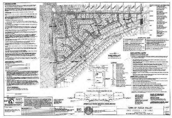
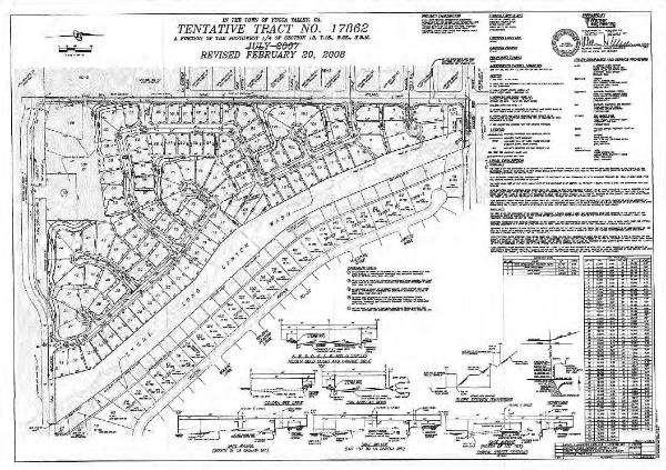
7 the Town Council will authorize construction bidding for the recommended playground improvements. Sage Estates, Final Map The project involves the subdivision of approximately the development of 107 single family lots on a 63.4 acre parcel. The project also includes 4.68 acres of parks and open space, a sewer treatment plant, and public streets. The proposed project is located at the southeast corner of Golden Bee and Sage Avenue. With construction of this project, additional streets will be added into the Town s Maintained Road System. Simultaneously, the project will also form an assessment district whereby the property owners agree to tax themselves for street and drainage maintenance. Through the use of these tools, the new public streets will not take away existing financial resources from street maintenance efforts throughout the Town. Status: Final Map, grading plans, street improvements plans, drainage and flood control plans and related documents have been submitted to the Town and are in first plan check. According to the property owner, grading is anticipated to begin in late Town Council action on the final map is anticipated in the fall of 2014.
8
City of Kearney Capital Improvement Update October 1, TH STREET AND 17TH AVENUE IMPROVEMENTS
 56TH STREET AND 17TH AVENUE IMPROVEMENTS FUNDING: Bonded ESTIMATED COST: $3,885,000 COMPLETION DATE: Fall 2018 SCOPE OF PROJECT: Widening of 56th Street from 6th Avenue to 19th Avenue, and widening 17th
PROJECTS UNDER CONSTRUCTION
 Project Name Project Status Project Funding Project Manager PJ 2144 Clayton Rd-Treat Blvd Intersection Improvements Widen the Clayton Road/Treat Blvd intersection and upgrade the traffic signal. Construction
Prince William Street Project (Grant Avenue to Wellington Road)
") Prince William Street Project (Grant Avenue to Wellington Road) 1 Goals Improve pedestrian and bike traffic safety Improve street drainage with curb & gutter Upsize water mains Enhance overall street appearance
Prince William Street Project (Grant Avenue to Wellington Road) 1 Goals Improve pedestrian and bike traffic safety Improve street drainage with curb & gutter Upsize water mains Enhance overall street appearance
STANDARD SPECIFICATIONS Book 2 ENGINEERING DRAWINGS INCLUDES ADDENDUMS
 STANDARD SPECIFICATIONS Book 2 ENGINEERING DRAWINGS INCLUDES ADDENDUMS July 23, 2018 Page 1 of 7 STANDARD LEGEND SYMBOLS (September, 1973)... AS-101A STANDARD LEGEND SYMBOLS (September, 1973)... AS-101B
THREE-YEAR CAPITAL IMPROVEMENT PLAN FY
 THREE-YEAR CAPITAL IMPROVEMENT PLAN FY2016 2018 Annual CIP Development Process Public Works & Engineering Divisions Prepare List of Capital Needs and Recommended Deferred Maintenance Public Works & Engineering
INFRASTRUCTURE EXISTING INFRASTRUCTURE A. Circulation B. Signals C. Drainage D. Utilities
 7.01. EXISTING INFRASTRUCTURE A. Circulation B. Signals C. Drainage D. Utilities 7.02. PROPOSED INFRASTRUCTURE A. Overall Concept B. Circulation C. Signals D. Drainage 7.03. INFRASTRUCTURE MAP A. Key Infrastructure
Canal Road City Limits (East of Van Dyke Ave) to Saal Road
 to Saal Road") Canal Road City Limits (East of Van Dyke Ave) to Saal Road Construction Update 9/14/2018 The ashalt paving on the southside of Canal Road is expected to start Saturday, September 15 (weather permitting)
Canal Road City Limits (East of Van Dyke Ave) to Saal Road Construction Update 9/14/2018 The ashalt paving on the southside of Canal Road is expected to start Saturday, September 15 (weather permitting)
Spring 2018 Construction Update
 Spring 2018 Construction Update Ward 3 Southwest Engineering Department Locust Street Bridge over the Des Moines River The Locust Street Bridge over the Des Moines River project is being let through the
PLANNED UNIT DEVELOPMENT STAFF REPORT Date: June 2, 2016
 # 9 ZON2016-01032 PLANNED UNIT DEVELOPMENT STAFF REPORT Date: June 2, 2016 DEVELOPMENT NAME JJT Properties LLC LOCATION 1147 & 1151 East I-65 Service Road South and 1180 Sledge Drive (Southeast corner
Municipality of Anchorage. Community Council Survey Capital Projects Needs Ranking Survey (ALPHABETICAL) Airport Heights
 Airport Heights") ANCHORAGE PARKS & RECREATION Nichols Park Design and improve neighborhood park 2008 Challenge Grant applicant. 2008 $500K State Grant for Neighborhood Parks. Tikishla Park Lighting, paved parking, hockey
ANCHORAGE PARKS & RECREATION Nichols Park Design and improve neighborhood park 2008 Challenge Grant applicant. 2008 $500K State Grant for Neighborhood Parks. Tikishla Park Lighting, paved parking, hockey
Fall 2017 Construction Update
 Fall 2017 Construction Update Ward 4 Southeast Engineering Department Riverwalk Red Multi-Use Trail Bridge Rehabilitation The Riverwalk Red Multi Use Trail Bridge was awarded to Cramer and Associates,
Cottage Grove Road Reconstruction. City of Madison Engineering
 Public Informational Meeting Cottage Grove Road Reconstruction October 8, 2015 Presentation Outline Introduction Project Purpose & Need Proposed Design Overview Environmental Concerns Pedestrian Needs
PLANNED UNIT DEVELOPMENT Date: April 5, 2018
 PLANNED UNIT DEVELOPMENT Date: April 5, 2018 DEVELOPMENT NAME SUBDIVISION NAME LOCATION Robert Myers Robert Myers 2955 and 2989 Dauphin Street (Southeast corner of Dauphin Street and Sage Avenue) CITY
TOWN OF PALM BEACH FOR IMMEDIATE RELEASE. Patricia Strayer, P.E., Town Engineer Phone: ,
 TOWN OF PALM BEACH DATE: October 19, 2017 FOR IMMEDIATE RELEASE MEDIA CONTACT: Patricia Strayer, P.E., Town Engineer Phone: 561-838-5440, Email: pstrayer@townofpalmbeach.com Construction and Traffic Highlights
#8) T-1409 CENTENNIAL & LAMB TENTATIVE MAP
 T-1409 CENTENNIAL & LAMB TENTATIVE MAP") #8) T-1409 CENTENNIAL & LAMB TENTATIVE MAP STAFF REPORT To: Planning Commission Meeting Date: June 14, 2017 Item: T-1409 Prepared By: Robert Eastman GENERAL INFORMATION: Applicant: Property Owner(s): Requested
#8) T-1409 CENTENNIAL & LAMB TENTATIVE MAP STAFF REPORT To: Planning Commission Meeting Date: June 14, 2017 Item: T-1409 Prepared By: Robert Eastman GENERAL INFORMATION: Applicant: Property Owner(s): Requested
PUBLIC MEETING NO. 4 OCTOBER 29, 2013
 PUBLIC MEETING NO. 4 OCTOBER 29, 2013 Arizona Canal Multi-use Path Public Process Current Design Process Public Meeting #1 - December 6, 2012 Public Meeting #2 - May 1, 2013 Public Meeting #3 September
VALLEY COUNTY MINIMUM STANDARDS FOR PRIVATE ROAD DESIGN AND CONSTRUCTION
 MINIMUM STANDARDS FOR PRIVATE ROAD DESIGN AND CONSTRUCTION Adopted November 28, 2005 TABLE OF CONTENTS DEFINITION OF TERMS...II I. DESIGN CRITERIA... 1 A. GENERAL DESIGN CRITERIA... 1 B. ROADWAY CLASSIFICATION...
Chapter 3: Existing Parks & Facilities
 Parks & Recreation Master Plan Update Chapter 3: Existing Parks & Facilities Town of Yucca Valley 3.0 EXISTING PARKS AND FACILITIES 3.1 Introduction This Chapter provides a description of the Town s existing
Section 3.0 Project Description
 Section 3.0 Project Description 3.0 PROJECT DESCRIPTION 3.1 PROJECT LOCATION AND SETTING PROJECT LOCATION Regionally, the Old Town Yucca Valley Specific Plan Area (SPA) is located near the western end
PLANNED UNIT DEVELOPMENT & SUBDIVISION STAFF REPORT Date: May 18, 2017
 & PUD-0000102-2017 PLANNED UNIT DEVELOPMENT & SUBDIVISION STAFF REPORT Date: May 18, 2017 NAME SUBDIVISION NAME Dauphin Creek Estates Subdivision Dauphin Creek Estates Subdivision LOCATION CITY COUNCIL
LITTLE ELM CAPTIAL IMPROVEMENT BOND STREET PRESENTATION
 LITTLE ELM 2009-2014 CAPTIAL IMPROVEMENT BOND STREET PRESENTATION Denton Frisco Little Elm Lewisville Legacy Southlake Grapevine Addison DENTON COUNTY & LEWISVILLE LAKE MATCHING FUNDS DENTON COUNTY BOND
Location. Served. Category. Units Start Year. Previous Appropriations
 20142018 CAPITAL IMPROVEMENT PLAN ($ Thouss) CITY OF HOUSTON STREET & TRAFFIC CONTROL Project: TC Jester: Washington to I 10 N100002 Paving Drainage Project Description Project provides for the design
Hunt Highway CELESTE PEMBERTON, CFM, CPM PINAL COUNTY CARLOS SANCHEZ SORIA, PE T.Y. LIN INTERNATIONAL
 Hunt Highway CELESTE PEMBERTON, CFM, CPM PINAL COUNTY CARLOS SANCHEZ SORIA, PE T.Y. LIN INTERNATIONAL Agenda Design Concept Report Phase 1 Phase 2 Phase 3 Phase 4 Phase 5 Questions Design Concept Report
Glencoe Elementary School Parking Lot Retrofit 825 SE 51 st Street
 Glencoe Elementary School Parking Lot Retrofit 825 SE 51 st Street Project Summary Project Type: Technologies: Institutional parking lot retrofit demonstration project Vegetated infiltration swale with
Building Great Neighbourhoods LAURIER HEIGHTS
 Building Great Neighbourhoods LAURIER HEIGHTS Building Great Neighbourhoods Building Great Neighbourhoods (BGN) is a longterm framework that coordinates and integrates the efforts of three City of Edmonton
BENJAMIN BANNEKER PARK FRAMEWORK PLAN (PLAN ADOPTION)
") BENJAMIN BANNEKER PARK FRAMEWORK PLAN (PLAN ADOPTION) COUNTY BOARD MEETING DECEMBER 16, 2017 County Board Consideration: Adopt the Benjamin Banneker Park Framework Plan and Design Guidelines Framework
BENJAMIN BANNEKER PARK FRAMEWORK PLAN (PLAN ADOPTION) COUNTY BOARD MEETING DECEMBER 16, 2017 County Board Consideration: Adopt the Benjamin Banneker Park Framework Plan and Design Guidelines Framework
CITY OF SIMI VALLEY MEMORANDUM
 CITY OF SIMI VALLEY MEMORANDUM AGENDA ITEM NO. 9.1 May 18, 2016 TO: FROM: Planning Commission Department of Environmental Services SUBJECT: REVIEW OF POTENTIAL FISCAL YEAR (FY) 2016-17 CAPITAL IMPROVEMENT
3.1 Survey Monument Preservation Guidelines for New and Reconstruction Projects. B. After construction and prior to recording Notice of Completion:
 3.0 SURVEY 3.1 Survey Monument Preservation Guidelines for New and Reconstruction Projects A. Prior to construction: 1. Public survey records are to be researched for the location of all possible survey
14 October 10, 2012 Public Hearing APPLICANT: MPB, INC
 14 October 10, 2012 Public Hearing APPLICANT: MPB, INC PROPERTY OWNER: MUNDEN & ASSOCIATES, LP STAFF PLANNER: Karen Prochilo REQUEST: Conditional Change of Zoning (AG-1 & AG-2 to Conditional O-2) ADDRESS
TIRZ 17/Redevelopment Authority Capital Improvements Plan Projects
 Gessner Widening: T-1701 What: Widen the road from a six-lane divided boulevard to an eight-lane divided boulevard street section, increase turn lanes, update traffic signal system, improve drainage by
City Center Specific Plan Amendments And Background Report City of Richmond. PLANNING COMMISION FINAL DRAFT January, 2001
 City Center Specific Plan Amendments And Background Report City of Richmond PLANNING COMMISION FINAL DRAFT January, 2001 TABLE OF CONTENTS Page LIST OF TABLES... LIST OF FIGURES... INDEX... OVERVIEW...
REPORT TO COUNCIL City of Sacramento
 REPORT TO COUNCIL City of Sacramento 915 I Street, Sacramento, CA 95814-2604' www.cityofsacramento.org CONSENT August 25, 2009 Honorable Mayor and Members of the City Council Title: Contract: Valley Hi
I-66 EASTBOUND WIDENING INSIDE THE BELTWAY PARDON OUR DUST MEETING
 I-66 EASTBOUND WIDENING INSIDE THE BELTWAY From the Dulles Connector Road (Route 267) to Fairfax Drive (Route 237) PARDON OUR DUST MEETING Bill Cuttler, PE (VDOT District Construction Engineer, Northern
City of Grande Prairie Development Services Department
 City of Grande Prairie Development Services Department ROYAL OAKS NORTH OUTLINE PLAN OP-07-03 NW 35-71-6 W6M May 7, 2007 Royal Oaks North Outline Plan TABLE OF CONTENTS 1.0 INTRODUCTION........ 3 1.1 Purpose
Town of Windham. Planning Department 8 School Road Windham, ME voice fax
 Town of Windham Planning Department 8 School Road Windham, ME 04062 voice 207.864-5960 fax 207.892.1916 MEMO DATE: TO: Staff Review Committee FROM: Amanda Lessard, Planner Cc: Ellen Rathbone, St. Germain
PRELIMINARY PLAT DESIGN REQUIREMENTS Updated 4/8/2016
 PRELIMINARY PLAT DESIGN REQUIREMENTS Updated 4/8/2016 The following items are required for the preliminary plat. Numbers correspond with those on the example preliminary plat. RENO COUNTY SUBDIVISION REQUIREMENTS
Presentation Item C Annotated Model Outline for a Framework for a Green Infrastructure Plan
 Date: August 17, 2016 To: From: Subject: Management Committee Dan Cloak, Consultant Presentation Item C Annotated Model Outline for a Framework for a Green Infrastructure Plan Recommendation: Receive the
Index to Projects by Project Name
 Index to Projects by Project Name 2062 1701 & 1711 Concord Avenue Purchase and Demolition of Structures 85 1279 1024 UF-802 UF-803 Affordable Housing 77 Annual CIP/TIP Management Program 105 Arnold Industrial
CND Committee Meeting April 10, 2018
 CND Committee Meeting April 10, 2018 Projects must: Serve a public purpose/benefit Have a detailed budget reflecting accurate project costs and match sources Have a detailed and achievable timeline including
BUSINESS OF THE CITY COUNCIL CITY OF MERCER ISLAND, WA
 BUSINESS OF THE CITY COUNCIL CITY OF MERCER ISLAND, WA December 10, 2007 Regular Business TOWN CENTER STREETSCAPE MANUAL Proposed Council Action: Review Streetscape Manual; Provide direction to staff on
CITY OF OZARK STANDARD DRAWING DETAILS FOR PUBLIC IMPROVEMENTS
 CITY OF OZARK STANDARD DRAWING DETAILS FOR PUBLIC IMPROVEMENTS 2010 EDITION CITY OF OZARK, MISSOURI REVISIONS TO THE 2009 EDITION The following revisions have been made to the 2009 edition of the city
MEETING DATE: November 12, 2013 SUBJECT: Accept Borden Road Bridge Improvement (CIP No )
") AGENDA REPORT Meeting of the San Marcos City Council MEETING DATE: November 12, 2013 SUBJECT: Accept Borden Road Bridge Improvement (CIP No. 88165) Recommendation Staff recommends the City Council adopt
AGENDA REPORT Meeting of the San Marcos City Council MEETING DATE: November 12, 2013 SUBJECT: Accept Borden Road Bridge Improvement (CIP No. 88165) Recommendation Staff recommends the City Council adopt
Metropolitan Area Planning Council 60 Temple Place, Boston, Massachusetts fax
 Metropolitan Area Planning Council 60 Temple Place, Boston, Massachusetts 02111 617-451-2770 fax 614-482-7185 www.mapc.org Serving the 101 Cities and Towns in the Metropolitan Boston Region MEMORANDUM
Project will Replace: Utilities Curb Pavement Lighting. City of Madison
 Project will Replace: Utilities Curb Pavement Lighting Replace sanitary sewer main & laterals Winnebago: Existing 8 main, 1905 Linden: Existing 6 main, 1915, upsize to 8 main Atwood: Existing 12 main,
Index to Projects by Project Name
 Index to Projects by Project Name Project # PROJECT NAME PAGE 2134 2119 PR-1109 Clayton Road (Market Street to Oakland Avenue) Sidewalk Repair 911 System Replacement and Dispatch Room Remodel ADA Barrier
WELCOME! 8 8:30 6: TH STREET IMPROVEMENTS. Open House. Presentation & Q&A
 WELCOME! 168 TH STREET IMPROVEMENTS 6:30 Open House 7 8 Presentation & Q&A 8 8:30 Open House WELCOME Todd Pfitzer City of Omaha Engineer Bob Stubbe City of Omaha Public Works Director Jon Meyer Project
GREENING THE BOULEVARD Master Plan Concepts for Venice Boulevard between Lincoln and Sawtelle
 GREENING THE BOULEVARD Katherine Spitz Associates Inc. 4212½ Glencoe Avenue Marina Del Rey, CA 90292 310 574 4460 Fax 574 4462 January 2008 Table of Contents Overview Proposed Design Improvements Illustration
Illustration of Eastlake Farmer s Cooperative Grain Elevator. Chapter 5: implementation 5-1
 Illustration of Eastlake Farmer s Cooperative Grain Elevator Chapter 5: implementation 5-1 chapter 5: implementation Introduction The Eastlake Subarea Plan includes a wide range of recommendations intended
CHAPTER 8. Mrs. Zimman s Class - Central Elementary
 SUSTAINABILITY CHAPTER 8 Mrs. Zimman s Class - Central Elementary 8.1 OVERVIEW Green infrastructure also known as low impact development (LID) and environmental or sustainable site design is an environmentally
Town of Portola Valley General Plan. Nathhorst Triangle Area Plan
 Town of Portola Valley General Plan Amended December 10, 1997 Table of Contents Introduction... 1 Planning Area... 1 Objectives... 2 Principles... 2 Standards... 4 Description... 4 Community Commercial...
Grand River Ravines Georgetown Township
 Grand River Ravines Georgetown Township Project Description: The Grand River Ravines County Park property is composed of the 68-acre former Fillmore at the Bend Open Space purchased in 1999 and two more
2018 Woodhill Road Improvements Public Informational Meeting. September 28, :00 pm
 2018 Woodhill Road Improvements Public Informational Meeting September 28, 2017 5:00 pm Project Personnel Introductions Will Manchester, City of Minnetonka, Director of Engineering Chris LaBounty, City
PLANNED UNIT DEVELOPMENT & PLANNING APPROVAL STAFF REPORT Date: April 4, 2013
 PLANNED UNIT DEVELOPMENT & PLANNING APPROVAL STAFF REPORT Date: April 4, 2013 NAME LOCATION The North American Islamic Trust, Inc. 63 East Drive (East side of East Drive, 400 South of Old Shell Road, and
Shell Beach Road Streetscape Frequently asked Questions
 Shell Beach Road Streetscape Frequently asked Questions General What is the Shell Beach Road Streetscape Improvements Project? The overall goal of the Shell Beach Road Streetscape Improvement project is
MPRD s Keith Mione (Community) Park Midlothian Road Entrance Traffic Signals
 Park Midlothian Road Entrance Traffic Signals") MPRD s Keith Mione (Community) Park Midlothian Road Entrance Traffic Signals Purpose: The Midlothian Road entrance to Mundelein Park & Recreation District s (MPRD s) Keith Mione (Community) Park would
MPRD s Keith Mione (Community) Park Midlothian Road Entrance Traffic Signals Purpose: The Midlothian Road entrance to Mundelein Park & Recreation District s (MPRD s) Keith Mione (Community) Park would
STORMWATER UTILITY FREQUENTLY ASKED QUESTIONS
 STORMWATER UTILITY FREQUENTLY ASKED QUESTIONS What is Stormwater? Stormwater is water that falls to the ground during a precipitation event. When land is undeveloped or covered with vegetative surface,
West Dennis Center: Bass River to Old Main Street. West Dennis Business District: Old Main Street to Dennis Commons
 West Dennis Center: Bass River to Old Main Street West Dennis Business District: Old Main Street to Dennis Commons Dennisport Center: Dennis Commons to Division Street Main Street Project Goals Project
City of Yorba Linda Memorandum
 City of Yorba Linda Memorandum Date: June 15, 2011 Date: To: From: Honorable Chairman and Members of the Parks and Recreation Commission Mike Kudron, Acting Director of Parks and Recreation SUBJECT: BACKGROUND
CITY OF MANHATTAN BEACH STAFF REPORT. THROUGH: Marisa Lundstedt, Director of Community Development
 CITY OF MANHATTAN BEACH STAFF REPORT TO: Planning Commission THROUGH: Marisa Lundstedt, Director of Community Development FROM: Tony Olmos, Director of Public Works DATE: April 29, 2015 SUBJECT: Determination
University Parkway Corridor Plan. Public Workshop Sept. 18, 2017
 University Parkway Corridor Plan Public Workshop Sept. 18, 2017 AGENDA 1. Overview of Process 2. Study Area 3. Components of the Plan 4. What We Know 5. What We Have Heard 6. Tonight s Input 7. Next Steps
Tucson Koi & Water Gardens
 OV113-031 Tucson Koi & Water Gardens CONDITIONAL USE PERMIT SITE ANALYSIS 05.22.2014 Property Owners Walter & Jane Wong Family Investments, LLP 5437 East 3rd Street Tucson, Arizona 85711 Tucson Koi and
Edenfield Avenue Green Street Demonstration Project Neighborhood Meeting
 Edenfield Avenue Green Street Demonstration Project Neighborhood Meeting Edenfield Avenue Green Street Demonstration Project Neighborhood Meeting Road Reconstruction Elements Grant Background What is a
SH 199 Corridor Master Plan. Community Meeting No. 2 May 31, 2017
 Community Meeting No. 2 May 31, 2017 Transportation Projects On or Near SH 199 SH 199 from 0.3 miles south of FM 1886 to south end of Lake Worth bridge Construct freeway mainlanes and frontage roads 10-Year
MAIN STREET RECONSTRUCTION PROJECT PRE-CONSTRUCTION PUBLIC INFORMATION SESSION AGENDA
 MAIN STREET RECONSTRUCTION PROJECT PRE-CONSTRUCTION PUBLIC INFORMATION SESSION 7:00 P.M. TO 8:30 P.M. NOVEMBER 21 st, 2017 PENETANGUISHENE MEMORIAL COMMUNITY CENTRE BRIAN ORSER HALL (61 Maria Street) 1.
GPCID Mall Boulevard & Gwinnett Place Drive Complete Street: Sectional View of Concepts
 Sectional View of Concepts PAVEMENT FEATURES PAVEMENTS INTERSECTION INTERSECTION TREATMENTS LANDSCAPE BUFFER LANDSCAPE DESIGN GPCID CD D: GWINNETT P LACE DRIVE & MALL B COMPLETE STREET DESIGN ELEMENTS
Farmersville Parkway Phase III
 Farmersville Parkway Phase III Application to the TIGER VI Discretionary Grant Program April 2014 Submitted By: City of Farmersville 205 South Main Street Farmersville, Texas 75442 972-782-6151 TABLE OF
4 January 11, 2012 Public Hearing APPLICANT:
 . 4 January 11, 2012 Public Hearing APPLICANT: MID-ATLANTIC AUTO PROPERTY OWNER: DZR, LLC STAFF PLANNER: Leslie Bonilla REQUEST: Conditional Use Permit (truck rental, automobile service, and automotive/bulk
Waukee. City of. The Key to Good Living
 Waukee City of The Key to Good Living City of Waukee FY15 - FY20 CIP Project Summary FY2015 FY2018 Parks Windfield Park Improvements Parks Centennial Park Amphitheater Parks Grant Park Improvements Parks
Public Works Project Delivery Report
 Public Works Project Delivery Report May 2017 San Gabriel Public Works delivers reliable infrastructure & welcoming public spaces by designing, constructing, operating & maintaining the City s streets,
DRAFT. CITY OF ESCONDIDO 11th Avenue Park WORKSHOP SUMMARY December 17, 2008
 DRAFT RJM DESIGN GROUP, INC. CITY OF ESCONDIDO 11th Avenue Park WORKSHOP SUMMARY December 17, 2008 INTRODUCTION This report summarizes the results of the planning process that was conducted as a part of
Carson Street Streetscape Improvements. Request for Proposals
 Carson Street Streetscape Improvements Request for Proposals Complete Design Services for a Landscape/Streetscape Plan for Carson Street (Pioneer Boulevard to Norwalk Boulevard) Submittal Deadline: October
Monroe Street Reconstruction. Public Preconstruction Meeting February 21, 2018
 Monroe Street Reconstruction Public Preconstruction Meeting February 21, 2018 Thank you to Edgewood College! Tonight s Agenda 1. Project Overview 2. Initial project schedule and phasing 3. Expectations
Monroe Street Reconstruction. Final Corridor Design Presentation & Open House August 16, 2017
 Monroe Street Reconstruction Final Corridor Design Presentation & Open House August 16, 2017 Thank you to Wingra School! Tonight s Agenda 1. Project Overview 2. Design Proposal & Preparing for Reconstruction
Fifth and Detroit Street Design May 2017 Capital Improvements Committee. DOWNTOWN Street Design
 1 Fifth and Detroit Street Design May 2017 Capital Improvements Committee Agenda 2 Review Street Configuration Prior Meeting Review Outreach Synopsis Functional Street Design Refinements Curb Edge, Turning
COMMUNICATION URBAN DESIGN REVIEW BOARD CITY OF DES MOINES, IOWA MAY 16, 2017 MEETING
 COMMUNICATION URBAN DESIGN REVIEW BOARD CITY OF DES MOINES, IOWA MAY 16, 2017 MEETING Subject: Recommendation Prepared by: PRELIMINARY DESIGN REVIEW OF LOCUST STREET BRIDGE CONSTRUCTION & COURT AVENUE,
BOISE, IDAHO COUNCIL WORK SESSION AGENDA September 19, :00 PM City Hall - Council Chambers
 BOISE, IDAHO COUNCIL WORK SESSION AGENDA September 19, 2017 5:00 PM City Hall - Council Chambers I. CALL TO ORDER II. WORK SESSION ITEMS 1. Interim Changes (10 mins) Presenter: Brent Davis, Finance and
The Van Ness Campus. Weekly Construction Bulletin #259
 The Van Ness Campus Weekly Construction Bulletin #259 Construction Update Week of September 24, 2018 The Van Ness Campus Weekly Bulletins are intended to help inform members of the community about upcoming
RECEIVE AN UPDATE ON THE ALMOND GROVE PHASE II PROJECT
 TOWN OF LOS GATOS COUNCIL AGENDA REPORT MEETING DATE: 12/20/2016 ITEM NO: 12 DATE: TO: FROM: SUBJECT: MAYOR AND TOWN COUNCIL LAUREL PREVETTI, TOWN MANAGER RECEIVE AN UPDATE ON THE ALMOND GROVE PHASE II
City of San Juan Capistrano PROJECT PRESENTATION NORTHWEST OPEN SPACE COMMUNITY PARK (CIP 09209) March 22, 2016 FOR THE PROJECT PRESENTATION
 March 22, 2016 FOR THE PROJECT PRESENTATION") City of San Juan Capistrano PROJECT PRESENTATION PROJECT PRESENTATION FOR THE NORTHWEST OPEN SPACE COMMUNITY PARK (CIP 09209) PLANNING COMMISSION 1 PROCESS & OBJECTIVES A. Develop a new Concept Plan for
City of San Juan Capistrano PROJECT PRESENTATION PROJECT PRESENTATION FOR THE NORTHWEST OPEN SPACE COMMUNITY PARK (CIP 09209) PLANNING COMMISSION 1 PROCESS & OBJECTIVES A. Develop a new Concept Plan for
APPLICATION FOR REZONING PROPERTY CITY OF HOLLAND, MICHIGAN. Name of Applicant. Address, and Phone # of Applicant
 APPLICATION FOR REZONING PROPERTY CITY OF HOLLAND, MICHIGAN Name of Applicant Address, Email and Phone # of Applicant Name and Address of Owner (if other than applicant) Ownership Interest of Applicant
Project Goal. RRRC Living Towns Planning Workshp. Town of Halifax Revitalization Project. Dynamic Planning & Management Duo: July 12, 2006
 Project Goal Town of Halifax Revitalization Project RRRC Living Towns Planning Workshp July 12, 2006 Town of Halifax Halifax County *** Revitalization Project Goal*** To create Economic Opportunity and
CITY PLANNING COMMISSION AGENDA. ITEM NO(s): C.1 C.3 STAFF: STEVE TUCK
: C.1 C.3 STAFF: STEVE TUCK") Page 34 CITY PLANNING COMMISSION AGENDA ITEM NO(s): C.1 C.3 STAFF: STEVE TUCK FILE NOS: CPC ZC 12-00035 QUASI-JUDICIAL CPC NV 12-00036 QUASI-JUDICIAL AR DP 12-00039 QUASI-JUDICIAL PROJECT: APPLICANT: OWNER:
Page 34 CITY PLANNING COMMISSION AGENDA ITEM NO(s): C.1 C.3 STAFF: STEVE TUCK FILE NOS: CPC ZC 12-00035 QUASI-JUDICIAL CPC NV 12-00036 QUASI-JUDICIAL AR DP 12-00039 QUASI-JUDICIAL PROJECT: APPLICANT: OWNER:
I-25 / Rio Bravo Interchange. I-25 / Rio Bravo Interchange. Presenters 11/30/2016 THIRD PUBLIC MEETING DECEMBER 1, 2016 NMDOT CN A300280
 I-25 / Rio Bravo Interchange TONIGHT S MEETING SCHEDULE OPEN HOUSE 6:00 PM TO 6:30 PM PRESENTATION BEGINS AT 6:30 PM Q & A FOLLOWING PRESENTATION CN A300280 / PNA300280 I-25 / Rio Bravo Interchange THIRD
Town of Avon Village Center. A New Village Center for Avon October, 2015
 Town of Avon Village Center A New Village Center for Avon October, 2015 A busy Avon Center approx. 1940 The Avon Town Center Study: In 2004 the Planning and Zoning Commission (PZC) undertook the Avon
7.5 Impacts on the Section 4(f) Properties
 Properties") constructive use, such as noise, air quality and visual impacts were also assessed. It was determined that this project would not introduce changes of an external nature that would affect the recreational
constructive use, such as noise, air quality and visual impacts were also assessed. It was determined that this project would not introduce changes of an external nature that would affect the recreational
Kittson Parkway / Watershed Park Parking Lot
 Kittson Parkway / Watershed Park Parking Lot Date Constructed: Summer 2005 Site Location / Description: Kittson Parkway, North Delta, British Columbia. Permeable parking lot adjacent to Watershed Park;
CHAPTER 8 INFRASTRUCTURE
 CHAPTER 8 INFRASTRUCTURE CHAPTER 8 SECTIONS 801 Introduction 802 Public Services/Facilities 803 Sewer System 804 Storm-Drain Facilities 805 Water-Distribution System 806 Street Network 801. INTRODUCTION
Public Works Annual Report FY
 Public Works Annual Report FY 2016-17 About the Department The Public Works Department is comprised of five divisions that oversee eight separate budget programs. These divisions include Administration,
Main Street Reconstruction From Ninth Line to Stouffer Street. Town of Whitchurch-Stouffville. Public Information Centre
 Main Street Reconstruction From Ninth Line to Stouffer Street Town of Whitchurch-Stouffville Public Information Centre November 23, 2016 4:30 to 6:00 pm & 7:00 to 8:00 pm 6240 Main Street, Stouffville
ARTICLE 6: Special and Planned Development Districts
 ARTICLE 6: Special and Planned Development Districts 6-10 Traditional Neighborhood Development (TND) District 6-10.10 Purpose and Intent The Traditional Neighborhood Development (TND) District provides
Project Status. Construction is underway for Phase 3. Overall Project Area and Schedule. Schedule of Current Construction Phases.
 I-95 Avenue Interchange Project Status Construction is underway for Phase 3. Overall Project Area and Schedule Phase 0: Completed 2010 Section GR0: Completed in Fallin 2010 Phase 2: Completed Section GR2:
EXHIBIT A 2019 FINANCING: PROJECT AUTHORIZATIONS
 EXHIBIT A 2019 FINANCING: PROJECT AUTHORIZATIONS Projects with Prior City Commission Authorization (No Changes) Downtown Canopy PW17B4CIP Prior Authorizing Ordinance: Ordinance No. 9428 Estimated Total
Rezoning Transportation Analysis Petition Number: General Location Identifier:
 From: Kelsie Anderson, PE Kelsie.Anderson@charlottenc.gov 704-432-5492 Staff Reviewer: Kory Hedrick, PE, PMP Khedrick@charlottenc.gov 704-432-6511 CDOT s review of this rezoning petition is intended to
VILLAGE OF CLEMMONS PLANNING BOARD DRAFT STAFF REPORT
 VILLAGE OF CLEMMONS PLANNING BOARD DRAFT STAFF REPORT PETITION INFORMATION Docket # C-226 Staff Megan Ledbetter Petitioner(s) JBJH Properties, LLC Owner(s) JBJH Properties, LLC Subject Property 5892-49-1766
BOARD OF SUPERVISORS BUSINESS MEETING ACTION ITEM
 BOARD OF SUPERVISORS BUSINESS MEETING ACTION ITEM Date of Meeting: September 2, 2015 # 9 SUBJECT: ELECTION DISTRICT: Identification of Funds for the Traffic Signal at the Intersection of Northstar Boulevard
CITY OF LATHROP. Department of Public Works. DESIGN & CONSTRUCTION Standard Details
 CITY OF LATHROP Department of Public Works DESIGN & CONSTRUCTION Standard Details January 2014 General G-1A Signature Blocks G-1B Signature Blocks G-2 Drafting Standards G-3 Drafting Standards G-4 Drafting
AGENDA ACTION ITEMS INFORMATION ITEMS
 NOACA Bicycle and Pedestrian Advisory Council Meeting Friday, March 21 st, 2014 10:30 a.m. NOACA Office 1299 Superior Avenue Cleveland, Ohio 44114 Phone: (216) 241-2414; website: www.noaca.org AGENDA ACTION
Section 9 NEIGHBORHOOD DESIGN
 Section 9 NEIGHBORHOOD DESIGN City of Lancaster Comprehensive Plan D u n k i n, S e f k o & A s s o c i a t e s, I n c. NEIGHBORHOOD DESIGN INTRODUCTION There are many ways in which a neighborhood can
County of El Dorado Standard Plans
 County of El Dorado Standard Plans Table of Contents Section 1 General Standards GS-01 General Legend and Abbreviations Section 2 Roads and Streets RS-01 RS-02 RS-03 RS-04 RS-05 RS-06 RS-07 RS-08 RS-20
Bexar County Public Works Department Flood Control Program
 Bexar County Public Works Department Flood Control Program Bulverde Rd. at Mud Creek Trib. A (SC-27) February 23 rd, 2016 Agenda Introductions Bexar County Flood Control (Engineering and PR) Office of