Don Narrows Workshop DRAFT MEETING REPORT Saturday, May 24, 2008 South Regent Park Recreation Centre
|
|
|
- Joleen McKenzie
- 6 years ago
- Views:
Transcription
1 Don Narrows Workshop DRAFT MEETING REPORT Saturday, May 24, 2008 South Regent Park Recreation Centre Introduction to the Workshop & this Report On Saturday, May 24, 2008 Toronto and Region Conservation hosted an afternoon workshop and site walk to explore opportunities to naturalize the Don Narrows. The results of the workshop will be used to inform conceptual design development for the Don Mouth Naturalization and Port Lands Flood Protection (DMNP) Environmental Assessment. Over 30 people participated, including members of the Community Liaison Committee for the DMNP EA, the Task Force to Bring Back the Don, the Don Watershed Council, the City of Toronto, and other individuals and groups that care about the Don. This draft meeting report was written by Nicole Swerhun, third party facilitator for the event. Please forward any thoughts, comments or suggested edits to Michelle Vanderwel at or ext Presentations delivered at the workshop included: Introduction to the DMNP EA, Marc Rose, Gartner Lee History of the Don Narrows, Jennifer Bonnell Existing Conditions & Constraints within the Don Narrows, Ken Dion, TRCA Recent activities of Task Force to Bring Back the Don in the Don Narrows, John Wilson Enhancement Opportunities to Consider for Naturalizing the Don Narrows, Ken Dion, TRCA Copies of the presentations are available on request from the TRCA. If you would like to receive a copy, please contact Michelle Vanderwel (see phone number and address above). The workshop discussion asked participants to share their thoughts and offer their advice regarding opportunities for naturalizing the aquatic habitat conditions within the Don Narrows and immediately adjacent to the banks. Feedback is captured in Section I of this report, and includes suggestions that cover everything from in stream structures and riparian plantings to bank reconstruction or other ideas. Suggestions for improvements beyond the immediate channel and banks were also recorded but will be considered independently from the DMNP EA (included here as Section II). In terms of next steps, TRCA will be reviewing the technical feasibility of the suggestions received from this workshop and also exploring other naturalization opportunities for the Don Narrows. Public follow-up with happen when the next Public Meeting is held as part of the DMNP EA. There were 30 participants at the meeting. The Agenda is included as Appendix A. Don Narrows Workshop Report May 24,
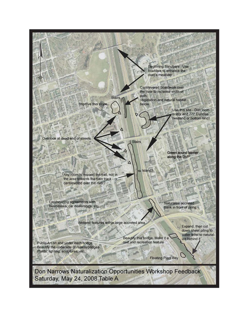
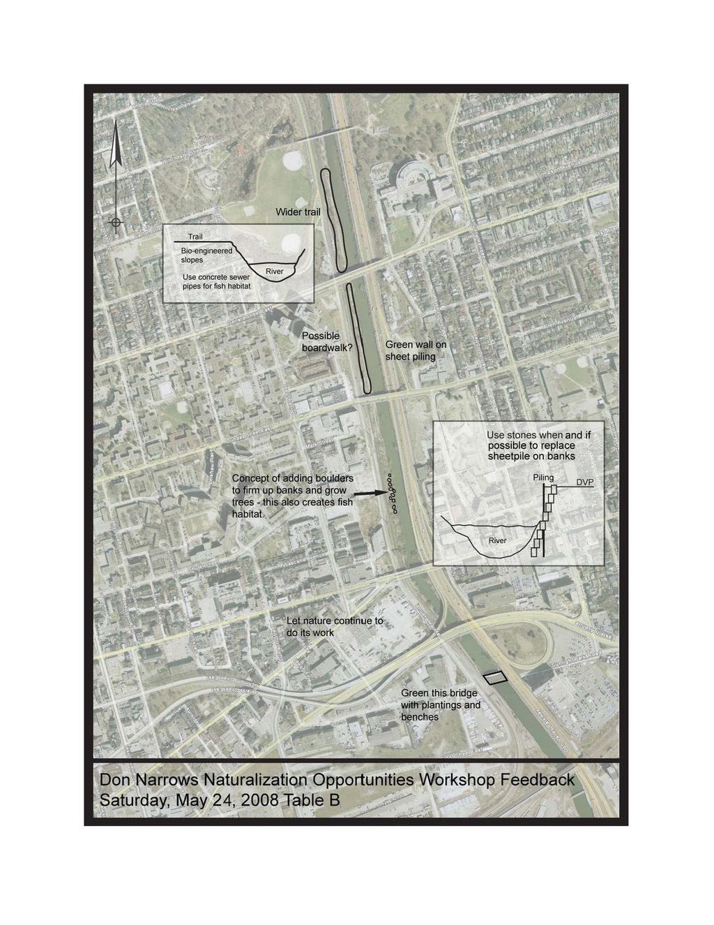
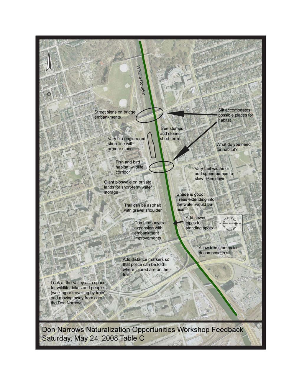
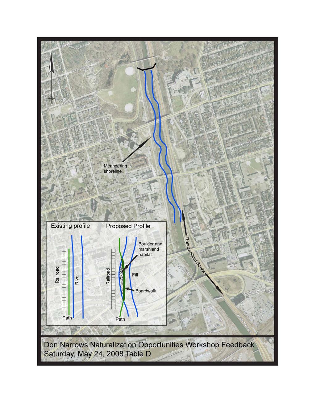
2 SECTION I. Ideas and Advice on Opportunities to Naturalize the Don Narrows This feedback focuses on opportunities for naturalization in the river itself and on the immediately adjacent river banks. It will be considered as part of the Don Mouth Naturalization and Port Lands Flood Protection (DMNP) EA. 1. Adjust the trail (see notes on maps from Tables A, B, and inset graphic on Table D map) Use the real estate that the path sits on to create opportunities. This could be done, for example, by excavating the area. This creates more room for the river water to flow, and may allow for some infilling on the east side. The path could also be elevated along certain portions which creates the room required for the river to meander. The path also doesn t have to be as linear. Consider meandering the trail so it s suspended over the river at some points. Similar to the above point: Take everything from river to rail out and re-build with what we want (e.g. wetland-like suspended/raised boardwalk) increases capacity to move water and naturalization. Move fence west a bit and create bike express route. 2. Animal access/wildlife/aquatic corridor (see especially map from Table C) The east side of the Don Narrows is a no man s land it could be a wildlife corridor. Consider creating a way for animals to cross river from west to east, but discourage people. It could be some kind of bridge that would allow water to flow through. Another option could be to build a culvert under the DVP, rail, and Bayview to allow water to flow through, especially in area of Riverdale Park. 3. Parks/green space/wetlands At Queen Street: enhance terrestrial habitat, east side; point bars; island excavate to sheet pile and let water flow through (nesting for waterfowl). No night lights don t want to draw people into natural wildlife area. Create more stewardship teams. 4. Walls of the riverbank (see especially insets on map from Table B) Over the long term, use stones instead of replacing piling (even if piling hidden). Between Eastern and North of Queen: cut down higher walls, protect behind to prevent scour; and have sheet pile along rail to protect rail and between rail and current river edge. Use rocks and other materials, large woody material cabled in. Put estuary hooks on either side. 5. Overall approach Need to have combination of: trail expansion, change shoreline, bioengineering so different type of plant material can thrive, green wall along Eastern Corridor, floating ponds Nature s doing good job, and encourage this to continue embrace what nature is already trying to do. This includes keeping a soft approach. Put an emphasis on biodiversity. Let nature take its course. Don Narrows Workshop Report May 24,
3 SECTION II. Ideas and Advice on Opportunities to Naturalize the Don Narrows This feedback focuses on opportunities beyond the river banks and is therefore outside the scope of the DMNP EA. That being said, there are a number of groups (e.g. TRCA, City of Toronto, Task Force to Bring Back the Don and others) who are involved in ongoing improvement activities and for whom this feedback is very valuable. 1. Transportation Give Filmport a dedicated DVP exit and then close the Don Roadway. Establish balanced transportation system, more towards people and trains versus cars. 2. Parks/green space/wetlands Look at opportunities for little parkettes at Labatt Street, other streets? City Planning could get involved in urban renewal. Use every little bit of green space at Queen. Add wetlands north of Riverdale pedestrian bridge. Create more stewardship teams. 3. Walls of the riverbank (see especially insets on map from Table B) Increasing the height of the wall beside the DVP is one option that has been previously considered (to avoid flooding the highway), but it would need to be built on a barge and one lane of the DVP would need to be closed for 3-4 months. At the time it was considered too costly. 4. Opportunities on the bridges Old Eastern Avenue bridge and Enbridge bridge are very low bridges. Look at ways to green the bridges as destinations (although may have to address access issues on the east side). Art on the bridge is good attracts people. The roof of the Enbridge bridge could be greened with plantings. Beautification: people fall in love with it; it creates constituency for stewardship advocacy do this through overlooks (see especially map from Table A), Eastern Bridge as rest and recreation spot. 5. Opportunities on Private Property Take private green property adjacent to buildings along valley and make public OR create BIA-like membership of private landowners and challenge businesses to improve Tree planting on private property is outside the scope of the EA, but there are areas to do it on the top of the banks (which improves bird migration and look) for example, at the Oak Street apartments, Don Incinerator site Don Narrows Workshop Report May 24,
4 APPENDIX A. Agenda DON NARROWS WORKSHOP Saturday, May 25, 2008 South Regent Park Recreation Centre 1:00 4:30 pm Workshop Purpose: To identify opportunities for naturalization of the Don Narrows, as part of the Don Mouth Naturalization and Port Lands Flood Protection (DMNP) EA Agenda: 1:00 pm Welcome & Introductions Adele Freeman, TRCA 1:02 Workshop Objectives & Agenda Review Nicole Swerhun, Facilitator 1:05 Presentations Introduction to the DMNP EA, Marc Rose, Gartner Lee History of the Don Narrows, Jennifer Bonnell Existing Conditions & Constraints, Enhancement Opportunities to Consider, Ken Dion, TRCA Recent activities of Task Force to Bring Back the Don in the Don Narrows, John Wilson Questions of Clarification 1:50 Site Walk Half of group will walk to Riverdale Park Pedestrian Bridge, and continue downstream. Other half of group will be bussed to Don Landing and continue upstream. Travel to start Station 1 & Talk (1:50 2:20) Walk to Station 2 & Talk (2:20 2:45) Walk to Station 3 & Talk (2:45 3:10) Travel back to Recreation Centre (3:10 3:25) 3:30 Workshop Discussion of Naturalization Opportunities 4:25 Next Steps 4:30 Adjourn Don Narrows Workshop Report May 24,
5
6
7
8
Vaughan Metropolitan Centre (VMC) Black Creek Renewal CLASS ENVIRONMENTAL ASSESSMENT
 Black Creek Renewal CLASS ENVIRONMENTAL ASSESSMENT") PUBLIC INFORMATION CENTRE Vaughan Metropolitan Centre (VMC) Black Creek Renewal Wednesday, May 10, 2017 6:00 p.m. to 8:00 p.m. Add photo Project Management, Environmental Assessment, Stormwater Management
PUBLIC INFORMATION CENTRE Vaughan Metropolitan Centre (VMC) Black Creek Renewal Wednesday, May 10, 2017 6:00 p.m. to 8:00 p.m. Add photo Project Management, Environmental Assessment, Stormwater Management
Edgeley Pond + Park Public Meeting
 Edgeley Pond + Park Public Meeting February 21, 2017 Purpose of the meeting This Public Meeting is an opportunity for you to review the project background, process and provide input. City of Vaughan staff
TRCA Roles and Responsibilities in Planning and Development
 TRCA Roles and Responsibilities in Planning and Development Regional Watershed Alliance November 14, 2018 Laurie Nelson, MCIP, RPP Associate Director, Planning and Policy Outline Roles and Legislation
Don Mouth Naturalization & Port Lands Flood Protection Project. Terms of Reference Stakeholder Consultation Report
 Don Mouth Naturalization & Port Lands Flood Protection Project Terms of Reference Stakeholder Consultation Report Appendix G Summary of Individual Consultations April 2006 Don Mouth Naturalization and
Albion Hills Conservation Area Master Plan. Public Information Session
 Albion Hills Conservation Area Master Plan Public Information Session 1 03.25.2014 Meeting Agenda 1. Project Introduction Property History Current Use Master Plan Process 2. Draft Vision Goals and Objectives
Ashbridges Bay Erosion and Sediment Control Project
 Ashbridges Bay Erosion and Sediment Control Project Project Brief Overview Toronto and Region Conservation Authority, in partnership with the City of Toronto, intends to carry out remedial erosion control
SECTION 5: REACH RECOMMENDATIONS/MAPS
 SECTION 5: REACH RECOMMENDATIONS/MAPS This section describes areas of concern and provides specific recommendations for each project reach. Locations of stormwater drains were from GIS coverage supplied
New Brighton Park Shoreline Habitat Restoration Project
 Vancouver Board of Parks and Recreation and Port Metro Vancouver New Brighton Park Shoreline Habitat Restoration Project Conceptual Design Public Consultation August 26 September 9, 2015 Discussion Paper
Meeting Agenda. City of Guelph. River Systems Advisory Committee. Agenda Items. Item 1, 2 and 3. Item 4 Ward to Downtown Pedestrian Bridge
 Meeting Agenda City of Guelph River Systems Advisory Committee September 19, 2018 City Hall, Meeting Room B From 4:00 to 6:00 p.m. Meeting Chair: Mariette Pushkar Agenda Items Welcome to all Item 1, 2
Bloor Street East Potential Ravine Portal Overlook and Access Passage to the Rosedale Valley and Don River Valley Ravine, Toronto, Canada
 TRANSFORMATIVE IDEA 2. GREAT STREETS Bloor Street Christie Pits Park Bloor St Spadina Ave Bathurst St Shaw St 1 Recognize the significant public realm improvements along Bloor Street and extend and enhance
Mount Dennis Mobility Hub Study Public Meeting December 12 th, :30pm 9:30pm York Memorial Collegiate, Cafeteria 2690 Eglinton Avenue West
 Mount Dennis Mobility Hub Study Public Meeting December 12 th, 2012 6:30pm 9:30pm York Memorial Collegiate, Cafeteria 2690 Eglinton Avenue West MEETING SUMMARY On December 12 th, 2012, over 89 people participated
Purpose of Open House #3
 Public Meeting #3 May 9, 2009 MVVA Team Purpose of Open House #3 The main purpose of this Open House is to present and seek input on the: Evaluation of transportation and infrastructure design alternatives
Public Meeting #3 May 9, 2009 MVVA Team
 Public Meeting #3 May 9, 2009 MVVA Team Welcome to the third Public Meeting for the Lower Don Lands Municipal Class Environmental Assessment (EA) Infrastructure Master Plan and Keating Channel Precinct
Baselands Trails Master Plan Public Meeting. April 28, 2015 Fire Academy, 895 Eastern Avenue, Toronto 6:30 p.m. to 9:00 p.m.
 Baselands Trails Master Plan Public Meeting April 28, 2015 Fire Academy, 895 Eastern Avenue, Toronto 6:30 p.m. to 9:00 p.m. Baselands Trails Master Plan Meeting Purpose To present and get feedback on:
Caledon Villas Corp. c/o Mr. John Spina 55 Blue Willow Drive Woodbridge, ON L4L 9E8 May 14, Floodplain Characteristics, Old Church Road
 Caledon Villas Corp. c/o Mr. John Spina 55 Blue Willow Drive Woodbridge, ON L4L 9E8 May 14, 2013 Re: Floodplain Characteristics, Old Church Road This letter serves to confirm that I, Linda Sober, have
HAYDEN ISLAND. Portland s Only Island Community. FINAL CONCEPT PLAN April 2008
 HAYDEN ISLAND Portland s Only Island Community FINAL CONCEPT PLAN April 2008 Introduction Hayden Island is the only island neighborhood in Portland and it provides a unique setting to its residents and
Wetland Design Manual. A1: Vision, core outcomes and aspirational outcomes
 Wetland Design Manual A1: Vision, core outcomes and aspirational outcomes Table of contents Introduction 5 Vision 6 Core outcomes 7 Effective pollutant removal and flow management... 7 Community safety...
Central Lake Ontario Conservation Conservation Lands Master Plan
 Conservation Lands Master Plan Top 13 Frequently Asked Questions 1. What are conservation lands? Where are these conservation lands located in the Central Lake Ontario Conservation watershed? Conservation
participant feedback summary
 participant feedback summary phase 1 themes: 4 may 2011 6:45pm 9:15pm old brooklin community centre Page 1 of 9 workshop details 16 participants attended 2 participants signed up to become an interested
Public Open House. Welcome! Presentation at 5:15 p.m. Please sign-in at the registration table
 Public Open House Welcome! Presentation at 5:15 p.m. Please sign-in at the registration table The Grand Avenue Extension Location and Environmental Study will determine the location of the extension of
TASK FORCE MEETING #6 SUMMARY
 TASK FORCE MEETING #6 SUMMARY CITY OF REDWOOD CITY INNER HARBOR SPECIFIC PLAN Tuesday, January 14, 2013 7:00 P.M. 9:30 P.M. Seaport Conference Center, 459 Seaport Court, Redwood City, CA 94063 I. WELCOME
APPENDIX L3. Table of Contents. SWP EA Information Sheets
 E N V I R O N M E N T A L A S S E S S M E N T APPENDIX L3 SWP EA Information Sheets Table of Contents EA Info Sheet 1... L3-1 EA Info Sheet 2... L3-3 EA Info Sheet 3... L3-5 EA Info Sheet 4... L3-7 SCARBOROUGH
MPDP VEGETATION ADVISORY WORKGROUP WORKSHOP #1
 DATE: TO: LOCATION: MPDP Vegetation Advisory Workgroup SWA Group Office, 1245 West 18 th Street Meeting Purpose: Workgroup Orientation Introduce Participants to the Project Goals Develop a Statement of
City of Iowa City Department of Neighborhood and Development Services Department of Parks and Recreation Department of Public Works City Manager s
 RFP Pre-submittal meeting December 18, 2015 City of Iowa City Department of Neighborhood and Development Services Department of Parks and Recreation Department of Public Works City Manager s Office Background
Scarborough Waterfront Project
 Scarborough Waterfront Project Public Information Centre #1 Environmental Assessment Terms of Reference September 10, 2014 Agenda Open House Presentation 7:00 to 7:30 pm Presentation 7:30 to 8:15 pm History
DOWNTOWN PARKS & PUBLIC REALM PLAN
 DOWNTOWN PARKS & PUBLIC REALM PLAN CHALLENGES The Parks and Public Realm Strategy addresses challenges associated with a growing Downtown, including: GOALS 3.3 New buildings will fit within their existing
Stormwater Regulations & Considerations Morse Study Area. Pam Fortun, P.E. CFM Senior Stormwater Treatment Engineer Engineering Services Division
 Stormwater Regulations & Considerations Morse Study Area Pam Fortun, P.E. CFM Senior Stormwater Treatment Engineer Engineering Services Division Stormwater Regulations Development Considerations Floodplain
Sherwood Forest Park REVITALIZATION PLAN. Public Meeting (P.I.C) # 3 JUNE / 25 /2015
 # 3 JUNE / 25 /2015") Sherwood Forest Park REVITALIZATION PLAN Public Meeting (P.I.C) # 3 JUNE / 25 /2015 1 Agenda i. Where we are in the process and schedule ii. Consultation process iii. Key messages from PIC#2 iv. Purpose
Sherwood Forest Park REVITALIZATION PLAN Public Meeting (P.I.C) # 3 JUNE / 25 /2015 1 Agenda i. Where we are in the process and schedule ii. Consultation process iii. Key messages from PIC#2 iv. Purpose
Gather information from online resources covering the following topics:
 Assignment #1: Regional Analysis Project Site Location: Greater Boston Area What comprises a region? The many elements within a region comprise the region as a whole. Natural as well as manmade environmental
Tentatively Selected Plan within Harlem River, East River and Western Long Island Sound Planning Region. First Level Costs. Federal Non-Federal Total
 HARLEM RIVER, EAST RIVER AND WESTERN LONG ISLAND SOUND PLANNING REGION Flushing Bay and Creek Ecosystem Restoration Source Feasibility Study Background Study Resolution (1994), Reconnaissance Report (1996),
Case Study Presentation of the Downtown Brampton Flood Protection Class EA
 Case Study Presentation of the Downtown Brampton Flood Protection Class EA Presented by: Kenneth M. Dion, Project Director Port Lands Integration, Waterfront Toronto (formerly Senior Manager, TRCA) At:
April 11, 2016 Park Board Chair and Commissioners General Manager Vancouver Board of Parks and Recreation New Brighton Salt Marsh - Preferred Concept
 TO: FROM: SUBJECT: April 11, 2016 Park Board Chair and Commissioners General Manager Vancouver Board of Parks and Recreation New Brighton Salt Marsh - Preferred Concept RECOMMENDATION A. THAT the Vancouver
TRCA Field Staking Protocol December 2016
 Page 1 of 6 TRCA Field Staking Protocol December 2016 This Protocol describes TRCA staff s current practice for field staking the physical top of bank, the physical toe of slope, and the limit of existing
Los Angeles River-Arroyo Seco Confluence Restoration Vision Plan. Professor Meredith McKenzie, JD Urban & Regional Planning Dept Cal Poly Pomona
 Los Angeles River-Arroyo Seco Confluence Restoration Vision Plan Professor Meredith McKenzie, JD Urban & Regional Planning Dept Cal Poly Pomona The Los Angeles River Watershed Arroyo Seco Watershed Map
Better Cycling. The City will update the cycling master plan (London ON Bikes) based on the approved BRT network.
 based on the approved BRT network.") Better Cycling Dedicated bike facilities will be constructed along BRT corridors where space is available. Nearby bike routes will also be upgraded to ensure a complete network is available for cyclists.
Better Cycling Dedicated bike facilities will be constructed along BRT corridors where space is available. Nearby bike routes will also be upgraded to ensure a complete network is available for cyclists.
MCCOYS CREEK RESTORATION 30% DESIGN
 MCCOYS CREEK RESTORATION 30% DESIGN THE MCCOYS CREEK RESTORATION PLAN The restoration plan aims to reduce flooding, restore ecosystem health, expand recreational opportunities along the creek, and connect
LEMON CREEK AREA PLAN. Steering Committee Meeting April 27, 2017
 LEMON CREEK AREA PLAN Steering Committee Meeting April 27, 2017 Agenda Roll Call (6:00pm) Approval of Minutes April 20, 2017 (5 minutes) Review and Approve the Natural Resources & Recreation Chapter, Goals,
Parks, Trails, and Open space Element
 Parks, Trails, and Open space Element Parks, Trails, and Open Space element Parks, Recreation, and Open Space are important components of the quality of life desired by the residents of Elk Grove. This
ENBRIDGE GAS DISTRIBUTION INC. Proposed Relocation for Ninth Line, Markham and Whitchurch-Stouffville. Environmental Screening Report
 Page 1 of 18 ENBRIDGE GAS DISTRIBUTION INC. Proposed Relocation for Ninth Line, Markham and Whitchurch-Stouffville Environmental Screening Report July 2011 Page 2 of 18 Table of Contents 1.0 INTRODUCTION
OVERMOUNTAIN VICTORY TRAIL BURKE CALDELL CORRIDOR FEASIBLITY STUDY REQUEST FOR QUALIFICATIONS CALDWELL COUNTY PATHWAYS
 OVERMOUNTAIN VICTORY TRAIL BURKE CALDELL CORRIDOR FEASIBLITY STUDY REQUEST FOR QUALIFICATIONS CALDWELL COUNTY PATHWAYS Caldwell County Pathways along with our co-partners City of Lenoir, Town of Gamewell,
Regional Context Statement
 Regional Context Statement REGIONAL CONTEXT STATEMENT 3. REGIONAL CONTEXT STATEMENT In 1995, the Provincial Government passed into law the Growth Strategies Act. The purpose of this provincial initiative
WELCOME TO OPEN HOUSE # 3
 Bayview Avenue Class Environmental Assessment Study Steeles Avenue to Elgin Mills Road WELCOME TO OPEN HOUSE # 3 Please sign in and join our mailing list Why Are We Here Tonight? Study Process and Purpose
TOWN OF BETHLEHEM MEETING SUMMARY LOCAL WATERFRONT REVITALIZATION PROGRAM UPDATE
 TOWN OF BETHLEHEM LOCAL WATERFRONT REVITALIZATION PROGRAM UPDATE MEETING SUMMARY Purpose: LWRP Update Public Workshop #3 Date and Time: October 24, 2017, 6:00 pm - 8:00 pm Location: Town Hall, 445 Delaware
Potential Green Infrastructure Strategies May 6, 2015 Workshop
 Potential Green Infrastructure Strategies May 6, 2015 Workshop Background The City of Cortland is developing the Tioughnioga Urban Headwaters Green Infrastructure Action Plan with funding from the National
Whitemarsh Comprehensive Plan Update: Housing & Land Use. Public Workshop #3: September 20, 2018
 Whitemarsh Comprehensive Plan Update: Housing & Land Use Public Workshop #3: September 20, 2018 Agenda Welcome Process Recap What We ve Heard The Plan Framework Review of Recommended Actions Land Use Housing
Urban runoff in my neighborhood (Capitol Hill) is heavy with trash and other debris.
 is heavy with trash and other debris.") South Platte River Meeting Comments & s #1 I am a huge fan of river areas and would love the Platte and surrounding waterways to improve to allow habitat for wildlife and recreation opportunities for citizens.
South Platte River Meeting Comments & s #1 I am a huge fan of river areas and would love the Platte and surrounding waterways to improve to allow habitat for wildlife and recreation opportunities for citizens.
St. Clair Avenue West Area Transportation Master Plan
 1 (Between Keele Street and Old Weston Road) Public Information Centre 1 December 2, 2015 2 Welcome Welcome to the first Public Information Centre for the St. Clair Avenue West Area. The panels will present
Community Visioning Workshop Prep
 Community Visioning Workshop Prep Visioning Workshop 73 Visioning Workshop: Public Events 1 2 3 4 74 Visioning Workshop: draft Schedule 75 Visioning Workshop: draft Schedule working to schedule stakeholder
Master Environmental Servicing Plan & Secondary Plan
 1 East Side Lands Stage 2 Master Environmental Servicing Plan & Secondary Plan Public Consultation Centre #4 March 20, 2018 Welcome! Today s Agenda Please sign in at the registration table. 6:00 pm 6:30
NORTHEAST RIVER CROSSING FUNCTIONAL PLANNING STUDY
 WELCOME Northeast River Crossing Functional Planning Study Phase 2 Public Meeting 4 to 8 PM Informal drop-in format and discussion tables Meeting Purpose Introduce the Northeast River Crossing Functional
Slough International Freight Exchange Proposals, Colnbrook+
 Welcome Welcome to this exhibition, which is being held in connection with our proposals for a new freight exchange facility on land to the north of the A4. Please take this opportunity to look at the
Glenborough at Easton Land Use Master Plan
 Vision Statement Sunrise Blvd. Hazel Ave. Prairie City Rd. Gencorp Property Lincoln Regional Airport 1.0 VISION STATEMENT The identifies City of the principles, goals, policies, and standards Lincoln that
WELCOME! 8 8:30 6: TH STREET IMPROVEMENTS. Open House. Presentation & Q&A
 WELCOME! 168 TH STREET IMPROVEMENTS 6:30 Open House 7 8 Presentation & Q&A 8 8:30 Open House WELCOME Todd Pfitzer City of Omaha Engineer Bob Stubbe City of Omaha Public Works Director Jon Meyer Project
Community Conservation Workshop. Saranac River Basin Communities
 Community Conservation Workshop Saranac River Basin Communities 2 Community Conservation Program Welcome! We have designed a Community Conservation Program that listens to the needs of community members.
MEETING SUMMARY. Please note that the meeting agenda is attached as Appendix A and detailed written feedback provided after the meeting as Appendix B.
 VMC Edgeley Pond + Park Public Meeting #1 Tuesday, February 21, 2017, 7:00 8:30 pm Vaughan City Hall, 2141 Major Mackenzie Drive West, Multi-Purpose Room Followed by a reception for the Vaughan Urban Jungle
Queensborough Eastern Neighbourhood Node. Community Open House
 Queensborough Eastern Community Open House The Vision The Queensborough Eastern will become the heart of eastern Queensborough. Through a sensitive mix of viable commercial and residential areas, the neighbourhood
Mavis Road Class Environmental Assessment
 Mavis Road Class Environmental Assessment Public Information Centre #2 Wednesday November 9, 2016 6:00 to 8:00 p.m. Please sign in and complete a comment sheet Review the displays on your own or join in
Chapter 3 Site Planning and Low Impact Development
 CHAPTER 3 Site Planning and Low Impact Development Chapter 3 Site Planning and Low Impact Development 3.0 Introduction The City of Charleston requires that major residential, large commercial (>1 acre),
HAZARD MITIGATION GOALS AND OBJECTIVES
 SEWRPC Community Assistance Planning Report No. 282, 2nd Edition CITY OF MILWAUKEE ALL HAZARDS MITIGATION PLAN UPDATE Chapter IV HAZARD MITIGATION GOALS AND OBJECTIVES [NOTE: Throughout this plan update
Rouge River Gateway Master Plan Update: 2011
 Rouge River Gateway Master Plan Update: 2011 Environmental Stewardship Cultural Heritage Recreation Economic Development Rouge Gateway Master Plan (2001) 1 Rouge Gateway Master Plan Update (2005) Significant
STREAM ALTERATION PRACTICES
 STREAM ALTERATION PRACTICES Stream Diversion Channel SDC DEFINITION A temporary channel constructed to convey stream flow around in-stream construction. PURPOSE Stream diversion channels are used to allow
Mendota Heights 2040 Comprehensive Plan Draft Vers
 4 Parks and Trails The City of Mendota Heights boasts a variety of recreational and open space opportunities. Few cities can claim access to regional trails, riverside and lakeside parks, scenic bluffs
Jonathan Sharpe, NL EHJV Program Manager
 Wildlife/Habitat Stewardship in Newfoundland and Labrador: The Stewardship Association of Municipalities i Inc. Wilson Hoffe SAM President Wilson Hoffe, SAM President Jonathan Sharpe, NL EHJV Program Manager
Lake and Stream Restoration Project
 Pre-project Fact Sheet May 2012 Toledo Botanical Garden (TBG) is a 60 acre public garden visited by more than 120,000 people annually. It is located in Toledo, Ohio in the Ottawa River watershed within
STAKEHOLDER COMMITTEE #4 PROJECT 21
 STAKEHOLDER COMMITTEE #4 PROJECT 21 MEETING S UMM ARY Wednesday, September 30 th, 2015 Ralph Thornton Center Toronto, Ontario This meeting summary is a compilation of questions and feedback received during
Your town s subdivision or land use ordinance standards should reference the following street standards, for example:
 Your town s subdivision or land use ordinance standards should reference the following street standards, for example: Streets shall be designed to move traffic safely and in a way that minimizes environmental
Town of Lyons Parks Flood Recovery Planning Process. Photograph courtesy of Ed Bruder
 Town of Lyons Parks Flood Recovery Planning Process Photograph courtesy of Ed Bruder Lyons Parks and Recreation Flood Recovery Update 1. Meadow Park Phase II - Project PW20B1 Estimated Completion: Summer
Please read the entire document
 projects impacting the waterfront revitalization area. The waterfront revitalization area of the town will have to subareas to the west and east of the village. Page 6 of 6 Wayfinding master plan create
1. Introduction
 Table of Contents 1. Introduction... 1-1 1.1 Project Background... 1-1 1.2 Project Goals and Objectives... 1-3 1.3 Proponent... 1-5 1.4 The Ontario EA Act... 1-6 1.4.1 Co-ordinated EA Process... 1-9 1.4.2
TOWN OF WHITBY REPORT RECOMMENDATION REPORT
 TOWN OF WHITBY REPORT RECOMMENDATION REPORT REPORT TO: Council REPORT NO: PL 95-09 DATE OF MEETING: October 13, 2009 PREPARED BY: Planning/Public Works Joint Report FILE NO(S): N/A LOCATION: N/A REPORT
Don Mills Crossing Study and Celestica Lands Development Application Community Meeting, Open House, and Breakout Discussions
 Consultation Summary Don Mills Crossing Study and Celestica Lands Development Application Community Meeting, Open House, and Breakout Discussions This report is not intended to provide a verbatim transcript
PUBLIC ENGAGEMENT & SIX THEMES OF THE PLAN
 Connecting the heart of Eagle to the soul of the river - Kathy Chandler-Henry, Commissioner Eagle County CHAPTER 1 PUBLIC ENGAGEMENT & SIX THEMES OF THE PLAN town of eagle - river corridor plan 1 PUBLIC
Corridor Enhancements
 Corridor Enhancements Safety is MoDOT s first priority in widening and rebuilding I-70 across the state of Missouri. MoDOT also understands that the interstate - and its interchanges and overpasses - are
Public Information Centre No. 1 King-Vaughan Road Bridge Replacement Municipal Class Environmental Assessment City of Vaughan
 Public Information Centre No. 1 King-Vaughan Road Bridge Replacement Municipal Class Environmental Assessment City of Vaughan Date: April 7, 2016 Location: Al Palladini Community Centre, Meeting Room #1
GUIDELINES WESTON LOCATION: URBAN DESIGN GUIDELINES
 Development in the Weston area will be consistent with the following urban design guidelines. The guidelines correspond to Site and Area Specific Policies 45, 46, 47, 48, 49, 51, 52 and 232 in Chapter
Natural Shorelines. for Inland Lakes. A Landowner s Guide to using. to STABLIZE SHORELINES, Michigan s inland lakeshore.
 Natural Shorelines for Inland Lakes A Landowner s Guide to using NATURAL MATERIALS to STABLIZE SHORELINES, IMPROVE WATER QUALITY and ENHANCE WILDLIFE HABITAT along Michigan s inland lakeshore. Natural
Northeast Anthony Henday Drive Manning Freeway to Whitemud Drive Welcome to this Construction Information Session
 Manning Freeway to Whitemud Drive Welcome to this Construction Information Session Purpose To inform interested residents and businesses about the plans accommodation. Background: The Government of Alberta
Blackfriars Bridge Municipal Class Environmental Assessment. Public Information Centre #1 November 19 th, 2014
 Blackfriars Bridge Municipal Class Environmental Assessment Public Information Centre #1 November 19 th, 2014 Why are you here tonight? To determine the future requirements of the river crossing at Blackfriars
GENERAL LAND USE PLAN ELEMENT
 CITY OF Prepared by City of Medford Planning Department 200 South Ivy Street Medford, Oregon 97501 plnmed@ci.medford.or.us James E. Huber, AICP, Planning Director COMPREHENSIVE PLANNING SECTION John Adam,
SQUAMISH 2010 AND BEYOND COMMUNITY VISION
 Our plan has been imagined and created to be both pragmatic and visionary. At the core of the strategy is a consideration of the highway s role and its impact on the community. First and foremost in creating
Arkansas River Corridor
 Planning for Access Welcome to the Access Project. This project is a recreational planning effort in response to an interest by regional communities along the Arkansas River corridor. The project plan
Parks, Trails, and Open Space Element
 P arks, Recreation, and Open Space are important components of the quality of life desired by the residents of Elk Grove. This Element of the General Plan addresses the City s goals, policies, and actions
Executive Committee Meeting Addendum. #7/15 July 3, :30 A.M. HEAD OFFICE, 101 EXCHANGE AVENUE, VAUGHAN Members:
 Executive Committee Meeting Addendum #7/15 July 3, 2015 9:30 A.M. HEAD OFFICE, 101 EXCHANGE AVENUE, VAUGHAN Members: Maria Augimeri Michael Di Biase David Barrow Ronald Chopowick Vincent Crisanti Glenn
319 Grant: Baker Creek & Centenary Creek Restoration Initiative
 319 Grant: Baker Creek & Centenary Creek Restoration Initiative Objectives: Overview of Watershed Characteristics: Discussion of Project Tasks: Discussion of Watershed Management Plan: Presented by: Erich
Community Conservation Workshop. Lake Placid
 Community Conservation Workshop Lake Placid 2 Community Conservation Program Welcome! We have designed a Community Conservation Program that listens to the needs of community members. We are conducting
A Vision for Walnut Creek
 A Vision for Walnut Creek Photo: City of Clive Walnut Creek Booklet 8 of 8 Greater Des Moines Water Trails and Greenways 1 Table of Contents Booklet 1: Water Trails Strategies and Policies Booklet 2: Beaver
Summary Community Workshop #6 Beacon Day School Saturday, November 14, :00 a.m. 12:00 p.m.
 Summary Community Workshop #6 Beacon Day School Saturday, November 14, 2009 9:00 a.m. 12:00 p.m. Workshop Format and Process The City of Oakland is preparing a Specific Plan that will help define and determine
Yarra Strategic Plan community engagement summary
 Yarra Strategic Plan community engagement summary Between May and August 2018 Melbourne Water undertook community engagement to build the content of the draft Yarra Strategic Plan. This engagement included
Working Group Meeting
 April 4,, 2017 Parks Operations Bldg Working Group Meeting Arts Districts Overview Stormwater/RPA/Stream Considerations First Principles Agenda 7:00pm 7:05pm 7:10pm 7:40pm 8:30pm 9:40pm 9:45pm Welcome
Saranac River Trail Greenway C O N D I T I O N S R E P O R T
 Saranac River Trail Greenway C O N D I T I O N S R E P O R T City of Plattsburgh Clinton County, NY For: Clinton County Final Issued: March 22, 2017 This document was prepared for the New York State Department
Riparian Buffer on the Bushkill Creek. Policies
 Riparian Buffer on the Bushkill Creek Riparian buffers provide numerous benefits to landowners and the community by protecting groundwater recharge areas, providing flood control, providing stormwater
Arlington County Watershed Retrofits. Greg Hoffmann Center for Watershed Protection
 Arlington County Watershed Retrofits Greg Hoffmann Center for Watershed Protection March 18, 2010 About the Center for Watershed Protection Non-profit 501(c)3, non-advocacy organization Work with watershed
2. Purpose of the Undertaking
 Table of Contents 2. Purpose of the Undertaking... 2-1 2.1 Problem Assessment... 2-1 2.1.1 Ecologically Dysfunctional River Mouth... 2-1 2.1.2 Flood Risk Vulnerability... 2-2 2.1.3 Derelict Waterfront...
PICTURE CANYON Planning Riparian-Wetland Refugia in an Urban Setting
 PICTURE CANYON Planning Riparian-Wetland Refugia in an Urban Setting Rio De Flag Existing Conditions. Ephemeral stream; Limited riparian plants, habitats.. & Opportunities Water (effluent) available Restore
City of Los Angeles Department of Public Works
 City of Los Angeles Department of Public Works Environmental Scoping Meeting for the Proposed Sixth Street Park, Arts, River & Connectivity Improvements (PARC) Project May 3, 2017 1 Agenda Introductions
17 Jul 2002 PUBLIC NOTICE
 17 Jul 2002 Regulatory Branch PUBLIC NOTICE ------------- 1. Pursuant to Code of Federal Regulations 33 CFR 325.2(a)(8), the Chicago District issued permits or other approvals, withdrawals, appeals or
Task Force Meeting #8
 March 11, 2014 AGENDA 7:00 Welcome/Housekeeping Laura Stetson 7:05 Public Comment 7:20 Presentations BIAC 101/84 Interchange InnVision Shelter Network Redwood City Update 7:35 Revised Guiding Principles
HUMBER BAY PARK EAST BUILDING PROJECT Architectural Community Resource Group Meeting #2 July 5, 2017
 HUMBER BAY PARK EAST BUILDING PROJECT Architectural Community Resource Group Meeting #2 July 5, 2017 Update on project, approach, and timing; Provide an overview of the precedents, program/uses, technical
Montana Stream Permitting
 Montana Stream Permitting A Guide for Conservation District Supervisors and Others Conservation Districts Bureau Montana Department of Natural Resources and Conservation June 2001 CONTRIBUTORS Committee
ANDERSON RIVER PARK SIDE CHANNEL HABITAT RESTORATION PROJECT. Public Outreach Meeting June 5, 2017
 ANDERSON RIVER PARK SIDE CHANNEL HABITAT RESTORATION PROJECT Public Outreach Meeting June 5, 2017 Welcome and Introductions Providing Feedback Anderson River Park is an important part of the community