City of Fairfax, Virginia City Council Work Session
|
|
|
- Rosamond Brooks
- 6 years ago
- Views:
Transcription
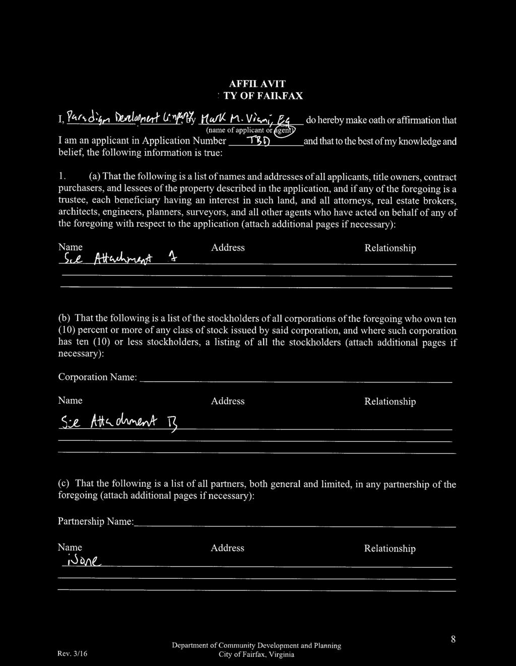
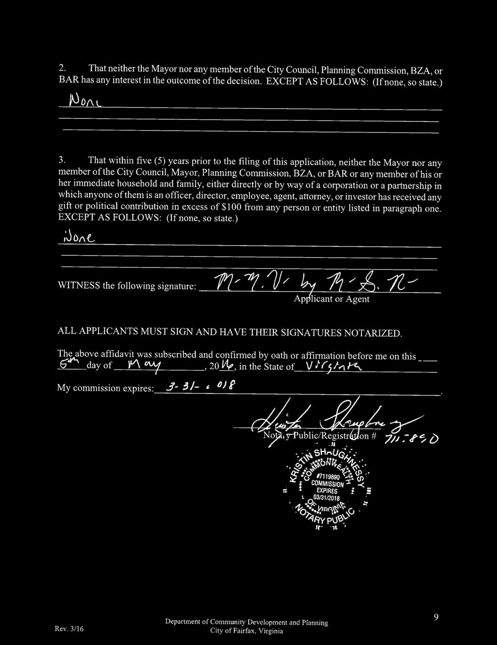
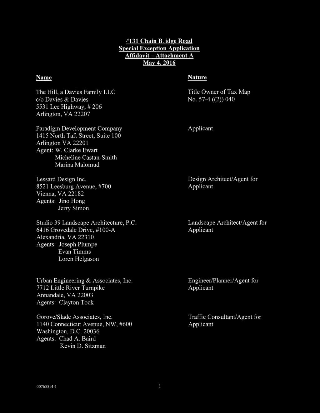
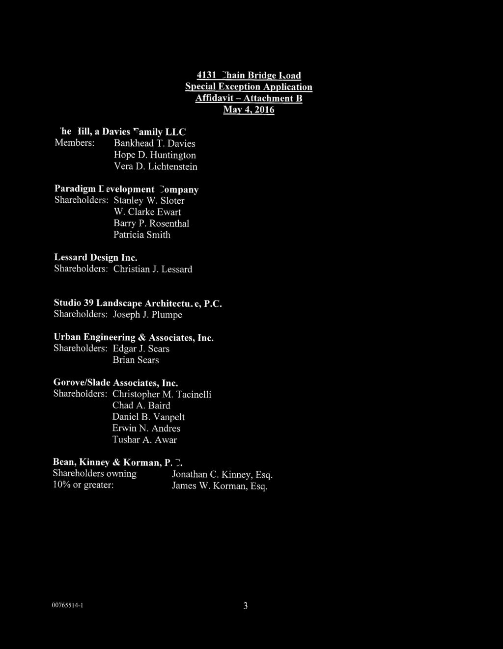
1 City of Fairfax, Virginia City Council Work Session Agenda Item # WS 2 City Council Meeting 7/5/2016 TO: FROM: SUBJECT: Honorable Mayor and Members of City Council Robert Sisson, City Manager Request of Paradigm Development Company for a City Council work session to discuss the proposed redevelopment of the property at 4131 Chain Bridge Road, informally known as the Davies Property. ISSUE(S): SUMMARY: Informational Work Session of City Council to discuss a proposed redevelopment of the subject property. An application was submitted and accepted on May 4, The applicant is seeking initial input on the proposal as currently designed from City Council. The applicant proposes to replace the existing single family home with 315 multifamily apartment units in a single six-story structure. The proposal is dependent on a rezoning from R-2 Residential to RPD Residential Planned Development as well as utilization of code provisions from the Old Town Fairfax Transition Overlay District and the Old Town Redevelopment Option. FISCAL IMPACT: RECOMMENDATION: ALTERNATIVE COURSE OF ACTION: RESPONSIBLE STAFF/POC: COORDINATION: ATTACHMENTS: A fiscal impact analysis has not been conducted at this time. Staff will present a preliminary estimate at the time of the work session. Discussion. City Council may choose to postpone discussion. Paul Nabti, Senior Planner Jason Sutphin, Community Development Division Chief Brooke Hardin, Director, Community Development & Planning Community Development & Planning Public Works Parks and Recreation Building Code Historic Resources Public Safety Human Services City Attorney Staff Report Page 1


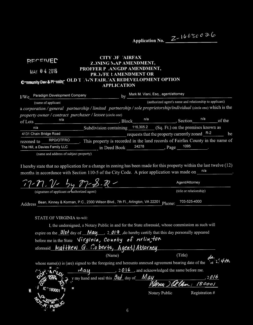
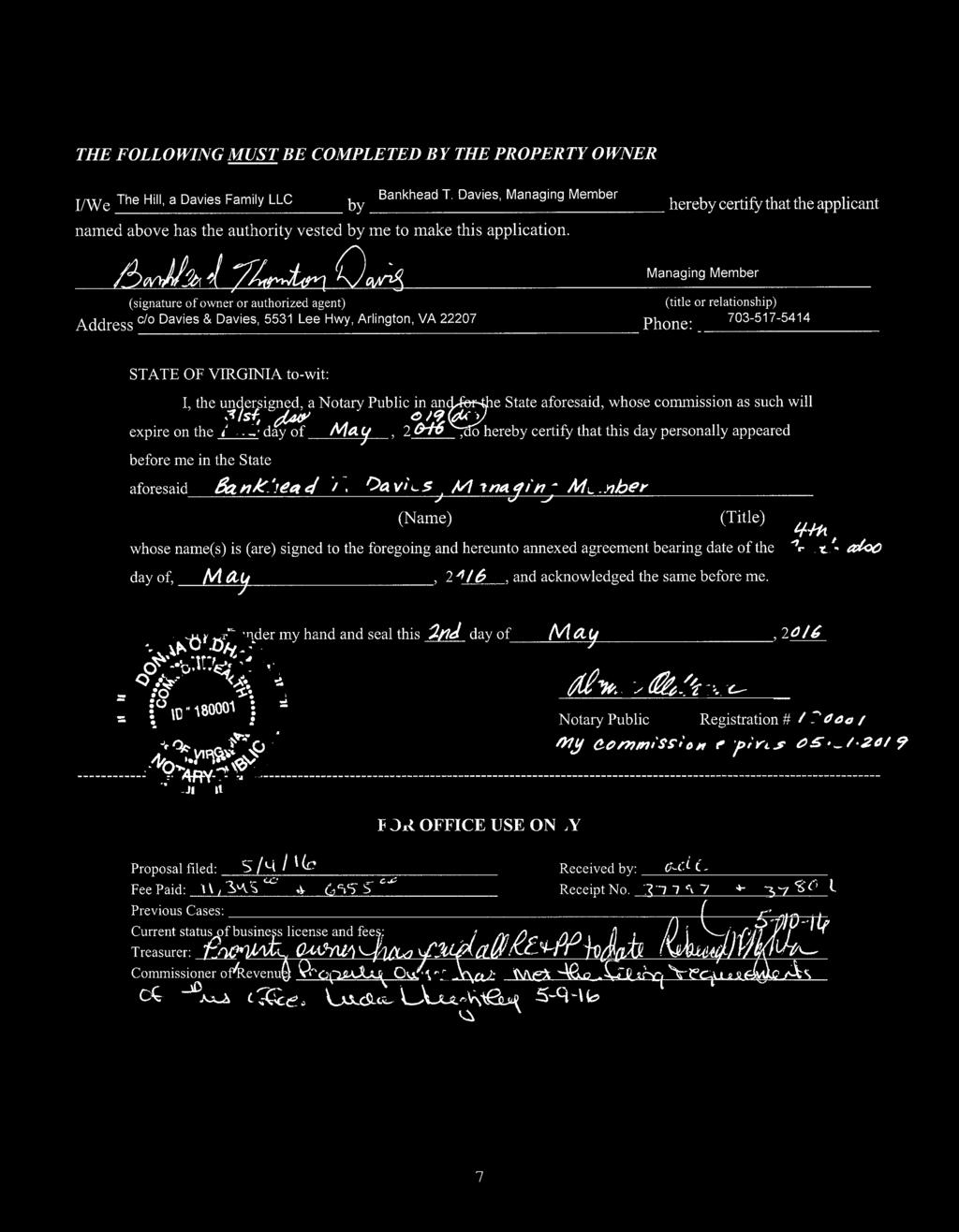
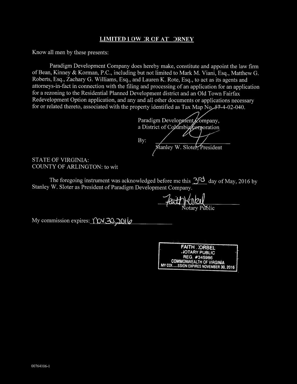
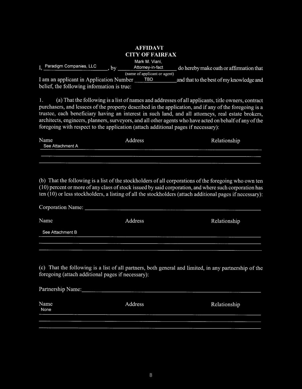
2 CITY OF FAIRFAX Department of Community Development & Planning Zoning Map Amendment (Z ) and Special Exception (SE ) Requests WORK SESSION DATE July 5, 2016 APPLICANT/ OWNER Paradigm Development Corporation AGENT Mark Viani Attorney/Agent PARCEL DATA Tax Map ID Street Address 4131 Chain Bridge Road Zoning District R2 Residential APPLICATION SUMMARY The applicant requests to rezone the subject site from R2 Residential and Old Town Fairfax Transition Overlay District (TOD) to RPD Residential Planned Development, maintaining the TOD and utilizing the Old Town Fairfax Redevelopment Option, to allow development of 315 multifamily units on 2.69 acres. In addition to the rezoning, the applicant is seeking special exceptions to the zoning code to allow the following: Special Exceptions 1. A reduction in required perimeter open space; 2. An increase in permissible impervious lot coverage; 3. A modification to required landscape screening for a parking garage, and; 4. A reduction in the minimum required number of parking spaces. Waivers 1. An increase in permissible height in the TOD and an increase in the number of stories as permitted utilizing the Old Town Fairfax Redevelopment Option. Location Map City Hall Armstrong Street Room 207 Fairfax Virginia (FAX)
3 Rezoning Z and Special Exception SE Page 2 BACKGROUND INFORMATION The 2.69-acre subject site stretches between Chain Bridge Road and University Drive, approximately 250 feet north of Armstrong Street. It is currently zoned R-2 Residential and is located within the TOD. The site is designated as Mixed Use on the Comprehensive Plan Future Land Use Map. The site sits directly across from the terminus of Judicial Drive at Chain Bridge Road and from Breckenridge Drive at University Drive. Surrounding uses include office commercial to the north and south, retail commercial and the County Judicial Complex to the west and residential townhomes to the east. The following table provides a summary of adjacent uses. Adjacent Properties Direction Existing Zoning Current Use Site North South East West R-2 Residential with TOD C-1 Office Commercial with TOD CPD Commercial Planned Development with TOD RT- Townhouse C-2 Retail Commercial with TOD, Planned Development Commercial (County) Residential Single Detached Commercial - Office Commercial - Office Residential - Townhouse Commercial - Retail; Government Facilities (County) Comprehensive Plan Future Land Use Designation Mixed-Use Mixed-Use Mixed-Use Residential - Medium Business-Commercial; Public Facilities (County) The site is currently occupied by a 4,936 square foot single-family home that was built in The house is oriented toward Chain Bridge Road with an entrance driveway from the northwest corner of the property. There is no access to the site from University Drive. PROJECT PROPOSAL The applicant proposes to replace the existing single family house with 315 multifamily apartment units and associated parking and amenities, for an overall density of 117 dwelling units per acre (DUA). The proposed plan is arranged with the residential units in two u-shaped buildings at the eastern and western ends of the site with a parking garage located at the center, as shown in the figure below. City Hall Armstrong Street Room 207 Fairfax Virginia (FAX)

4 Rezoning Z and Special Exception SE Page 3 The residential buildings are primarily six stories, tapering to four stories closest to University Drive. The parking garage is proposed at seven stories. Open space is provided in courtyards at the centers of the two u-shaped buildings and in an area along the center of the south property line where the building form steps back. Vehicular access is provided from University Drive only. No inter-parcel access is proposed. Pedestrian access is provided from University Drive and Chain Bridge Road. REQUESTS In order to fully execute the aforementioned improvements, the applicant proposes the following land use requests for City Council action: Rezoning from R2 Residential to RPD Residential Planned Development Utilization of the Old Town Fairfax Redevelopment Option Special Exception to allow for a reduction of 25-0 minimum open space perimeter around the entirety of the development per code Section (2); Special Exception to allow impervious coverage to exceed 50% of the gross tract area per code Section (4); Special Exception to allow modifications to the required landscape screening adjacent to a parking structure per code Section (b). Special Exception to allow fewer than two (2) parking spaces to be provided for each multifamily residential unit per code Section (b)(1)(c). Waiver to allow a maximum height that exceeds 43 feet as permitted in the Old Town Fairfax Transition District and more than five stories as permitted through the Old Town Fairfax Redevelopment Option. These land use requests are subject to change based on further analysis by staff and design modifications to the proposal. ANALYSIS Staff analysis of the compliance of this proposal with the Comprehensive Plan and other City goals and policy is provided in Attachment 1. City Hall Armstrong Street Room 207 Fairfax Virginia (FAX)
5

6 ATTACHMENT 1. WORK SESSION ANALYSIS 4131 CHAIN BRIDGE ROAD Z and SE Staff seeks input from the City Council on the following items that are currently under review and discussion. Land Use: As shown in Figure 1, the site is designated as mixed use on the Comprehensive Plan Future Land Use Map, which seeks for a mix of retail type uses with office or residential uses. Residential uses are encouraged in the Old Town Fairfax Transition Overlay District (Transition District). Figure 1: Future Land Use Map Although the proposed addition of residential units to the Old Town area is encouraged by the Comprehensive Plan, the current proposal lacks a commercial component that would be supported by the mixed-use designation. The applicant has stated concerns with the economic viability of supporting commercial uses at this location. An analysis of key citations from the Comprehensive Plan related to uses for this site is provided in Attachment 2. 1


 Figure 2-2: West elevation (Chain Bridge Road) Although the north and south elevations are partially screened by other buildings and vegetation, these")
7 Building Form: The Old Town Fairfax Design Guidelines provide parameters for larger scale buildings in the Transition District, including the following: a. Traditionally scaled building forms should be provided by breaking up large facades and varying the roof lines. b. The tallest building heights are most appropriate toward the center of the site with building heights tapering down toward street frontages. Appropriate building heights at street frontages should be determined based on surrounding uses and building forms. This property is roughly 220 feet wide and 575 deep. The relatively narrow street frontages combined with the U-shaped concept for the buildings at the east and west ends of the property generally contribute toward a traditionally scaled building width as viewed from the two street frontages. These elevations are provided in Figures 2-1 and 2-2. Figure 2-1: East elevation (University Drive) Figure 2-2: West elevation (Chain Bridge Road) Although the north and south elevations are partially screened by other buildings and vegetation, these two elevations have a much more significant mass than the east and west elevations as shown in Figures 3-1 and 3-2. The overall length of the building is approximately 530 feet. The appearance of these elevations when approaching the site from the north or the south should be considered when determining appropriate building forms, height transitions and architectural treatments. As proposed, these two elevations conflict with the guidance of the Old Town Fairfax Design Guidelines. Figure 3-1: South elevation (as approached from City Hall/Inns of Court) 2

8 Figure 3-2: North elevation (as approached from Old Town) An analysis of key citations from the Old Town Fairfax Design Guidelines as they pertain to building form on this site is provided in Attachment 2. Building Height: A special exception is being requested to allow for an increase in maximum height within the Transition District from 43 feet and up to five stories through the Old Town Fairfax Redevelopment Option to 73.2 feet with a maximum of six stories. The Old Town Fairfax Redevelopment Option provides the following considerations for determining appropriate building heights: a) Compatibility with existing and proposed proximate structures; b) Effect of topographic conditions on the visual impact of the proposed structure; c) The extent to which the architectural design of the proposed building mitigates the impact of additional height; and d) Extent to which the proposed development contributes to or detracts from the planned character of Old Town Fairfax. Although there are buildings within the Transition District with six or more stories, the tallest buildings in the area south of the Historic District are five stories and around 60 feet in height. In addition, there are no buildings within the Transition District with a footprint of six stories with a footprint as large as the proposed building in this application. An increased height of six stories could be considered, provided that impacts of the additional height are mitigated by transitioning building heights based on surrounding building forms and uses, topographic conditions and characteristics of the streetscape on which the property fronts. The current proposal steps down the building height toward University Drive to four stories. No step down of building height is proposed along the Chain Bridge Road frontage. When considering whether or not a building height transition is sufficient to detract from the visual impacts of the taller building heights, the depth of the transition should be considered in addition to the height. In the current proposal, the building steps up to five stories 26 feet from the building face, and six stories 40 feet from the building face. This results in an ultimate building height of 69.5 feet, 60 feet from the University Drive property line as shown in Figure 4. 3

9 Figure 4: University Drive Building Step-Back Setbacks: 20 foot setbacks are provided along the two street frontages and 10 foot setbacks are provided along the north and south property lines. The dimensions of the street front setbacks may change as a result of potential dedications for sidewalks, but this would not impact the building location or distance from the building to the curb. All setbacks are in conformance with the requirements of the TOD and the Old Town Redevelopment Option, though the applicant is requesting a special exception from a 25 foot wide perimeter open space as required in the Residential Planned Development District. Vehicular Circulation: Vehicular access to the site is proposed through a single access point on University Drive near the north property line. This access point would serve a driveway that leads under the building to the garage. Access is also provided to a loading area adjacent to the driveway. The driveway and the loading area are both concealed by roll-up doors as can be seen in Figure 2-1. The submitted plans to not indicate where trash service would be provided. Given their orientation toward the right-ofway, the visual and functional impact of these components of the plan on areas outside the site should be considered as the design is refined. The proposed driveway entrance is located approximately 36 feet (curb to curb) from the existing driveway that serves BB&T Bank to the north, and approximately 40 feet offset from the edge of Breckenridge Lane across University Drive. The offset proposed allows for potential conflicts between vehicles making left-turn movements into the development and into Breckenridge Lane. This is of particular concern since both left-turning vehicles would share a center turn lane in the proposed road diet configuration as shown in Figure 5. 4

10 Figure 5: Potential University Drive Conflict Area A traffic study has been provided by the applicant to compare existing and potential traffic volumes on adjacent streets and associated intersection performance. Scenarios were developed to consider the existing lane configurations as well as the proposed road diet configuration. The analysis indicates that adjacent intersections operate at acceptable levels of service during AM and PM peak hours and would continue to operate at acceptable levels of service with the added volume from the proposed development in either roadway configuration. The study does indicate that left turn movements out of the proposed development onto northbound University Drive would operate below an acceptable level of service with the road diet configuration. Staff is currently reviewing the study to ensure that appropriate base figures were used in the analysis. Parking: A total of 527 parking spaces are proposed within the parking garage that serves the site, for a ratio of 1.67 spaces per unit where 2.0 spaces per unit are required. The applicant states that the proposed parking ratio is based on the requirements of the current draft of the Zoning Ordinance Rewrite. This ratio is based on the number of bedrooms in each unit, which has not yet been provided by the applicant. If the proposed parking ratio is in compliance with the Zoning Ordinance Rewrite, a special exception will still be requested for parking because this application falls entirely within the existing zoning ordinance. Three multifamily apartment developments have been approved in the City since 2013, each with a residential parking ratio of 1.6 spaces per unit. This ratio has been supported by analysis of requirements in peer jurisdictions and observations from the Institute for Transportation Engineer s Parking Demand Manual. The applicant also proposes six on-street parallel parking spaces across the property frontage on University Drive. Traffic volumes along University Drive are low enough that on-street parking could be provided without presenting a safety concern with the current lane configuration or the road diet configuration. These parking spaces are located in the public right-of-way and would be available to the public, though time restrictions could be imposed. They are not counted toward the number of parking spaces provided with this proposal. 5
11 Given the number of units proposed and the resulting number of parking spaces, City staff are evaluating the need for a second entrance to the parking garage to improve the level of service for vehicles leaving the garage, as mentioned above, and improve public safety access to the site. It should be noted that an entrance on Chain Bridge Road would need to be evaluated for potential impacts on signal timing along that corridor. Pedestrian Circulation: Sidewalk improvements are proposed on both the University Drive and Chain Bridge Road frontages. Streetscape design standards for the Transition District would be applicable to this site, including brick sidewalks and gas light fixtures. The applicant is consulting with staff on sidewalk widths, street tree locations and other specific design elements. In the current design, no pedestrian cross access is proposed through the site in a north-south direction or in an east-west direction. Staff has indicated a desire to allow for pedestrian cross-access due to the overall size of the block on which the site is located. The applicant has expressed concerns with allowing for north-south cross access which would bisect the site, but is exploring opportunities to allow for east-west cross-access along the northern or southern property lines. Bicycle racks are proposed to serve guests of the building along the University Drive and Chain Bridge Road frontages. Staff has also requested that secure and enclosed bicycle facilities be provided within the building to serve residents. Environmental Considerations: The proposed plan increases the overall amount of impervious area on the site from approximately 20% to 74%. The maximum permitted coverage in the RPD is 50%, though hardscape for pedestrian areas may be excluded from the calculation, which results in a request to permit lot coverage of 65.86%. A special exception is being requested to allow for this increase. Impacts to stormwater management on the site and in the surrounding area are discussed under utilities below. Since there are no requirements for tree cover under the Old Town Redevelopment Option, the applicant has not supplied information on existing or proposed tree cover aside from the new trees as shown on the landscape plan. Staff has requested this information for comparison purposes. Utilities: This project would be required to meet new Virginia Stormwater Management Regulations and stormwater requirements of the City of Fairfax Public Facilities Manual, which call for a reduction in phosphorous discharge from existing conditions for redeveloping sites. The site plan identifies preliminary locations for both below-ground and above-ground stormwater holding and treatment facilities. There are no stormwater controls on the existing site. As a result, stormwater generally flows in two directions, one toward Chain Bridge Road and the other toward the southeast corner of 6
12 the site where it runs into the University Drive gutter. Stormwater improvements would control flow by capturing and treating it per state regulations and directing it to an underground system. The applicant is exploring options to connect to an existing stormwater pipe under Breckenridge Drive rather than University Drive to avoid directing the flow toward the University Drive/Armstrong Street intersection, which has capacity concerns. Per City Code, all existing and proposed on-site utilities would have to be relocated underground through this redevelopment effort. There are no above ground utilities along the University Drive frontage for this property. There is one pole on site along the Chain Bridge Road frontage. This pole provides connections across Chain Bridge Road. One mast arm traffic signal pole is also located within the property along the Chain Bridge Road frontage. This pole would need to be replaced if any alterations to it are proposed through the development. Architecture: The building is designed with different architecture styles to reflect that of the surrounding properties on each frontage. The University Drive frontage has a more residential appearance with a lower building height, gabled roofs, window shutters and a lighter masonry color. The Chain Bridge Road frontage has a more commercial appearance with a flat roof, fewer architectural details and darker masonry. In general, the architectural designs for both faces are in keeping with that of the Old Town area with traditional elements and masonry as the primary façade material. The shape of the lot, combined with the concept of U-shaped buildings at the east and west ends results in a building scale along the frontages that is generally in keeping with the goals of the Old Town Fairfax Design Guidelines. Despite this, the overall height along both frontages is not consistent with surrounding properties. In addition, when viewed from the north or south, the building has a more monolithic appearance that is not consistent with existing structures in the Old Town area or the goals of the Old Town Fairfax Design Guidelines. Along the north façade, the partial screening of the parking garage is insufficient to blend in the utilitarian structure with existing uses within Old Town Fairfax. In particular, the highest points of the garage, which are the most visible, remain un-screened. This application will be subject to approval by the Board of Architectural Review, whose decision is partially based on the criteria set forth in the Old Town Fairfax Design Guidelines. Potential Proffers: Though staff has not discussed specific proffers with the applicant at this time, there are several proffers that are likely to be included in the final proposal that merit input from City Council at this stage. Following is a summary of these proffers: Inclusion of Affordable Dwelling Units: No provisions for affordable dwelling units were included in the initial application package, though the applicant has indicated that they are aware of the City s affordable housing policy. Following this policy, this proposal would include 19 units provided at rents affordable to 60% of the area median income. 7
13 Parks and Recreation: This development is expected to impact the Department of Parks and Recreation in two ways; one based on location, and the other based on use. Regarding location, the site is within close proximity to Providence Park, Old Town Square and Ratcliffe Park, and with minimal on-site open space, is expected to increase user demand on those facilities. Existing needs are identified in the Parks and Recreation Strategic Master Plan. Regarding use, the proposed redevelopment is expected to attract a relatively higher proportion of singles and non-family households, a demographic that is underserved in the existing City park system. Improved City recreational facilities may be needed to serve this demographic. Transportation Demand Management Plan: As with any development project of this scale, a Transportation Demand Management Plan (TDM) will be required to convey the applicant s efforts in reducing vehicle trips generated by the development. The site is well situated to take advantage of its proximity to Old Town and George Mason University, in addition to existing transit service, and walking and biking trails. Staff will work with the applicant to develop a plan to enhance transit and pedestrian infrastructure and encourage residents to use alternative transportation modes. Schools: Contributions to schools are typically offered based on the number of additional school children anticipated compared to that of existing conditions, or to that of a by-right development on the same site. Other Proffers: Potential proffers which could be included in the rezoning application based on recent concerns within the City as well as the specific context of the subject site and proposed development may include the following: 1. Wayfinding and cycling signage 2. Public Art 3. Energy Efficiency 4. Architectural survey and Phase I Archeological Study 8
14 ATTACHMENT 2 Review of Applicable Citations from the Comprehensive Plan and Old Town Fairfax Design Guidelines Comprehensive Plan: The subject site is designated as Mixed Use on the Comprehensive Plan Future Land Use Map. The following description of Mixed Use is provided from the Land Use Chapter of the plan. Certain locations within the City call for a flexible land use category that will support development with a mixture of uses. The mixed use category supports a combination of commercial, residential and institutional development to be tailored to specific site conditions and transition needs. Residential uses are generally acceptable, but the intensity of residential uses should be moderated in areas where lower intensity development provides appropriate transitions, such as in portions of Old Town Fairfax for example. In addition, residential uses should not be the dominate ground floor use within any of the mixed use districts (Comprehensive Plan, page 164) Uses, or features of uses, that directly further a City goal or objective, such as those identified in this or other chapters of this Plan, should be encouraged and provided reasonable flexibility to achieve that goal or objective (Comprehensive Plan, page 164) In addition to having a Mixed Use designation, the site is located within the Old Town Fairfax Transition Overlay District (TOD). Following are descriptions of preferred development forms and uses within that district as provided in the Land Use Chapter of the Comprehensive Plan. Old Town Fairfax [Historic District and Transition District combined] should contain a variety of land uses, including retail shops, restaurants, offices, residential uses, shared or public parking facilities, and open spaces. The preferred mix of uses would include restaurants, retail, and personal services on the ground floor of buildings that are intermixed along street frontages with residential or office uses above. (Comprehensive Plan, page 165) The comprehensive plan further supports residential uses in the Transition Overlay District subject to certain conditions as described below: Residential development in the Transition Area is essential to the success of Old Town Fairfax and should be guided by the site-specific descriptions of the Land Use Plan. Upper floor-residences should be encouraged in the Historic Downtown, and additional residential units sited nearby to encourage evening and weekend activities to assure a viable setting for commercial uses. (Comprehensive Plan, page 167)
15 The applicant proposes to construct 315 multifamily apartment units on the 2.69 acre site, for an overall density of 117 dwelling units per acre (DUA) with no retail or commercial component. Old Town Fairfax Design Guidelines: Located within the Old Town Fairfax Transition Overlay District, certain aspects of the design of the site, particularly in regard to building scale and massing, are guided by the language of the Old Town Fairfax Design Guidelines. Applicable citations from the Design Guidelines along with an analysis of the conformance of the proposal with those citations are provided below: The Old Town Fairfax Design Guidelines provide recommendations for building forms and architectural styles within Old Town Fairfax, consisting of the Old Town Fairfax Historic District and the Old Town Fairfax Transition Overlay District. Specific recommendations are provided for larger structures that are located within the Historic District or the Transition Overlay District. Although they are referred to as multi-lot structures, their applicability applies to all larger scale residential building types as described below: Multi-lot building type: while this building type needs to respond to the various building conditions on the site, it also should employ design techniques to reduce its visual presence. The uses of the large buildings may be commercial, professional or residential or a mixture of any or all of these types. (page 44) Residential building type: While there is limited opportunity to construct many more residential structures, there is the possibility of new such developments within the transition district. These designs could be townhouses or multifamily larger scaled structures that could also contain other uses as well. These larger buildings containing multifamily uses should be treated as a multi-lot structure in terms of their designs. (pages 44-45) Based on the above descriptions, the proposed residential development should be considered a multi-lot structure and should be designed in accordance with the design guidelines intended for such buildings. Following is a summary of applicable guidelines for consideration in the building design of multi-lot structures. 1. Building Form: A. In areas with large multi-lot buildings, divide the façade to smaller and more traditionally scaled units. (page 46) B. Use forms in new construction that relate to those of existing neighboring buildings on the street (page 46)
16 C. Break up large monolithic box-like designs into more complex designs. (page 46) D. Most historic commercial buildings in downtown are twenty to thirty feet wide. If new buildings are wider than this size, their primary facades should be divided into bays to reflect the predominant width of the existing buildings. (page 48) E. Multi-lot buildings that are large scales should have a varied roof line to break up the mass of the design using gable and/or hipped forms. (Page 49) The proposed design breaks up the building mass and uses forms that relate to existing neighboring buildings for the Chain Bridge Road and University Drive street frontages. The north and south elevations have a more monolithic façade. 2. Building Height: A. Consider reducing the scale of the building at the streetfront façade and increasing the scale as the building steps back on the lot. (page 46) B. Because of the variety in building types and periods in Fairfax s Transition District, there is a corresponding variety in building heights of one to five stories and widths. (page 48) C. In order to reinforce the traditional Main Street wall of two to three stories of the neighboring historic district, consider stepping back the upper floor levels of larger multi-lot structures in the transition district. (page 48) In general, building heights of up to five stories are in keeping with existing structures in the TOD, though building heights of up to six stories may be acceptable in some portions of the site depending on adjacent land uses and frontages. The tallest portions of the building should be located near the center of the site with building heights tapering down to the two frontages. Building heights at the two frontages should be in harmony with existing development in proximity to the site along each street. Height step backs should be significant enough that the taller portions of the building do not counter the effect of the lower building heights along the frontages. The north and south elevations are visually prominent components of the building which should be considered when determining appropriate building heights. 3. Street Presence: A. Reinforce the scale of the Historic District in the Transition District by including elements such as porches, entrances, storefronts, and decorative features. (page 49) Although some decorative features are present in the elevations provided for the two facades with street frontages, only one of the four building facades that faces a street is depicted with a pedestrian building entrance, and none of the façades include store fronts.

17

18

19

20

21

22

23

24

25

26

27

28

29

30

31

32

33

34

35

36
City of Fairfax, Virginia City Council Work Session
 City of Fairfax, Virginia City Council Work Session Agenda Item # 12a City Council Meeting 5/8/2018 TO: FROM: SUBJECT: Honorable Mayor and Members of City Council Robert Sisson, City Manager Request of
Policies and Code Intent Sections Related to Town Center
 Policies and Code Intent Sections Related to Town Center The Town Center Vision is scattered throughout the Comprehensive Plan, development code and the 1994 Town Center Plan. What follows are sections
EXISTING COMPREHENSIVE PLAN
 EXISTING COMPREHENSIVE PLAN Town Center Land Use Element: V. LAND USE POLICIES Town Center Mercer Island's business district vision as described in "Your Mercer Island Citizen-Designed Downtown" was an
Jason D. Sutphin, Community Development Division Chief. Through: Brooke Hardin, Director of Community Development and Planning
 Meeting Date: 12/18/2017 Agenda Item: 9a. MEMORANDUM To: Chairman Cunningham and Members of the Planning Commission From: Jason D. Sutphin, Community Development Division Chief Through: Brooke Hardin,
ARTICLE 6: Special and Planned Development Districts
 ARTICLE 6: Special and Planned Development Districts 6-10 Traditional Neighborhood Development (TND) District 6-10.10 Purpose and Intent The Traditional Neighborhood Development (TND) District provides
ARLINGTON COUNTY, VIRGINIA
 ARLINGTON COUNTY, VIRGINIA County Board Agenda Item Meeting October 15, 2005 DATE: September 28, 2005 SUBJECT: Request to Advertise the adoption of the 2005 Clarendon Sector Plan C. M. RECOMMENDATION:
SECTION TWO: Overall Design Guidelines
 SECTION TWO: Overall Design Guidelines This section provides overall design principles and guidelines for the Gardnerville Mixed-use Overlay. They provide criteria for mixed-use places consisting of residential,
McDonald s Restaurant - Purcellville Town of Purcellville Special Use Permit Statement of Justification July 24, 2014
 Introduction / Written Statement McDonald s Restaurant - Purcellville McDonald s Corporation is proposing to redevelop the existing McDonald s eating establishment with a drive-through located at 121 N
12 January 12, 2011 Public Hearing APPLICANT: TAILWIND DEVELOPMENT GROUP,LLC PROPERTY OWNER: CITY OF VIRGINIA BEACH
 12 January 12, 2011 Public Hearing APPLICANT: TAILWIND DEVELOPMENT GROUP,LLC PROPERTY OWNER: CITY OF VIRGINIA BEACH STAFF PLANNER: Faith Christie REQUEST: Conditional Change of Zoning (from PD-H1 Planned
WEST LOOP DESIGN GUIDELINES CHECKLIST
 WEST LOOP DESIGN GUIDELINES CHECKLIST Section 1.0 General Strategies 1.1 DESIGN EXCELLENCE: ENCOURAGE HIGH QUALITY AND INNOVATIVE DESIGN OF NEW BUILDINGS WITHIN THE WEST LOOP WITHOUT BEING PRESCRIPTIVE
D1 September 11, 2013 Public Hearing APPLICANT:
 D1 September 11, 2013 Public Hearing APPLICANT: BEACH MUNICIPAL FEDERAL CREDIT UNION PROPERTY OWNER: SISTERS II, LLC STAFF PLANNER: Karen Prochilo REQUEST: Conditional Change of Zoning (AG-2 Agriculture
Be it enacted by the Town Board of the Town of Guilderland that the following new A (Transit Oriented Development (TOD) District) is adopted:
 District) is adopted:") Local Law No. 4 of 2018 (Adoption of 280-18A (Transit Oriented Development District) Be it enacted by the Town Board of the Town of Guilderland that the following new 280-18A (Transit Oriented Development
Local Law No. 4 of 2018 (Adoption of 280-18A (Transit Oriented Development District) Be it enacted by the Town Board of the Town of Guilderland that the following new 280-18A (Transit Oriented Development
MONTGOMERY COUNTY PLANNING DEPARTMENT THE MARYLAND-NATIONAL CAPITAL PARK AND PLANNING COMMISSION
 MONTGOMERY COUNTY PLANNING DEPARTMENT THE MARYLAND-NATIONAL CAPITAL PARK AND PLANNING COMMISSION MCPB Item No. Date: 1/26/12 Hanover Shady Grove, Sketch Plan 320120020 Joshua Sloan, Coordinator, Joshua.Sloan@MontgomeryPlanning.org,
VILLAGE OF CLEMMONS PLANNING BOARD DRAFT STAFF REPORT
 VILLAGE OF CLEMMONS PLANNING BOARD DRAFT STAFF REPORT PETITION INFORMATION Docket # C-226 Staff Megan Ledbetter Petitioner(s) JBJH Properties, LLC Owner(s) JBJH Properties, LLC Subject Property 5892-49-1766
14 October 10, 2012 Public Hearing APPLICANT: MPB, INC
 14 October 10, 2012 Public Hearing APPLICANT: MPB, INC PROPERTY OWNER: MUNDEN & ASSOCIATES, LP STAFF PLANNER: Karen Prochilo REQUEST: Conditional Change of Zoning (AG-1 & AG-2 to Conditional O-2) ADDRESS
Civic Center District
 Civic Center District The Civic Center district is the civic and social heart of Warrenville, containing such public buildings as the City Hall, Warrenville Public Library, Police Station, Park District
Town Center (part of the Comprehensive Plan)
") Town Center (part of the Comprehensive Plan) Mercer Island Town Center Looking North (2014) In 1994, a year-long process culminated in a set of design guidelines and code requirements for the Town Center
Town Center (part of the Comprehensive Plan) Mercer Island Town Center Looking North (2014) In 1994, a year-long process culminated in a set of design guidelines and code requirements for the Town Center
Clairtrell Area Context Plan
 Clairtrell Area Context Plan March 2005 Urban Development Services City Planning Contents 1. Introduction... 4 2. Development Structure... 6 2.1 Streets... 7 2.1.1 Sheppard Avenue and Bayview Avenue...
VILLAGE OF SKOKIE Design Guidelines for Mixed-Use Districts NX Neighborhood Mixed-Use TX Transit Mixed-Use CX Core Mixed-Use
 VILLAGE OF SKOKIE Design Guidelines for Mixed-Use Districts NX Neighborhood Mixed-Use TX Transit Mixed-Use CX Core Mixed-Use TABLE OF CONTENTS CHAPTER 1 SITE DESIGN Purpose 1 CHAPTER 2 SITE DESIGN Streetscape
599 Kennedy Road - Official Plan Amendment and Zoning Amendment Application - Preliminary Report
 STAFF REPORT ACTION REQUIRED 599 Kennedy Road - Official Plan Amendment and Zoning Amendment Application - Preliminary Report Date: March 7, 2017 To: From: Wards: Reference Number: Scarborough Community
Gold Line Bus Rapid Transit Transit Oriented Development (BRTOD) Helmo Station Area Plan
 Helmo Station Area Plan") Appendix F Gold Line Bus Rapid Transit Transit Oriented Development (BRTOD) Helmo Station Area Plan Introduction and Purpose of the Plan The Gold Line Bus Rapid Transit facility is an eleven-mile dedicated
Appendix F Gold Line Bus Rapid Transit Transit Oriented Development (BRTOD) Helmo Station Area Plan Introduction and Purpose of the Plan The Gold Line Bus Rapid Transit facility is an eleven-mile dedicated
MIXED-USE VILLAGE OVERLAY FLOATING DISTRICT
 MIXED-USE VILLAGE OVERLAY FLOATING DISTRICT Zoning regulations developed by committee to the Planning Board for the Town of DeWitt, NY Issue date: 13 July 2017 revised 3/12/2018, revised 4/26/2018, 5/9/2018
Review of Opportunity Area C Draft Comprehensive Plan and Draft BOS Follow-On Motions. Special Working Group Meeting March 4, 2015
 Review of Opportunity Area C Draft Comprehensive Plan and Draft BOS Follow-On Motions Special Working Group Meeting March 4, 2015 The slides that follow identify where the draft Comprehensive Plan has
A. WHAT IS A GENERAL PLAN?
 I. Introduction A. WHAT IS A GENERAL PLAN? A general plan is the planning guideline for the future of a city. It contains goals and policies which regulate urban development, the protection of the natural
B L A C K D I A M O N D D E S I G N G U I D E L I N E S for Multi-family Development
 B L A C K D I A M O N D D E S I G N G U I D E L I N E S for Multi-family Development Adopted June 18, 2009 This section of the Design and focuses on site planning and design guidance for new multi-family
PLANNING COMMISSION. Agenda Item # 3.
 PLANNING COMMISSION Agenda Item # 3. CASE SUMMARY Conditional District Rezoning Planning Commission February 4, 2015 CD-9-215 Jeff Walton, 341-3260, jeff.walton@wilmingtonnc.gov Staff recommendation CONDITIONAL
Request Conditional Rezoning (R-15 Residential to Conditional A-24 Apartment) Staff Recommendation Approval. Staff Planner Jimmy McNamara
 Staff Recommendation Approval. Staff Planner Jimmy McNamara") Applicant Franklin Johnston Group Management & Development, LLC Property Owner Virginia Wesleyan College Public Hearing July 12, 2017 City Council Election District Bayside Agenda Item 3 Request Conditional
Applicant Franklin Johnston Group Management & Development, LLC Property Owner Virginia Wesleyan College Public Hearing July 12, 2017 City Council Election District Bayside Agenda Item 3 Request Conditional
523, 525 and 525A Adelaide Street West - Zoning Amendment Application - Preliminary Report
 STAFF REPORT ACTION REQUIRED 523, 525 and 525A Adelaide Street West - Zoning Amendment Application - Preliminary Report Date: May 12, 2012 To: From: Wards: Reference Number: Toronto and East York Community
The transportation system in a community is an
 7 TRANSPORTATION The transportation system in a community is an important factor contributing to the quality of life of the residents. Without a sound transportation system to bring both goods and patrons
5.1 Site Plan Guidelines
 5. Community Core Guidelines Development of the Community Core will take place by plan of subdivision and site plan approval. It will occur in a phased manner that will reflect the timing of residential
REQUEST Current Zoning: O-15(CD) (office) Proposed Zoning: TOD-M(CD) (transit oriented development mixed-use, conditional)
 (office) Proposed Zoning: TOD-M(CD) (transit oriented development mixed-use, conditional)") Rezoning Petition 2016-117 Zoning Committee Recommendation January 4, 2017 REQUEST Current Zoning: O-15(CD) (office) Proposed Zoning: TOD-M(CD) (transit oriented development mixed-use, conditional) LOCATION
Rezoning Petition 2016-117 Zoning Committee Recommendation January 4, 2017 REQUEST Current Zoning: O-15(CD) (office) Proposed Zoning: TOD-M(CD) (transit oriented development mixed-use, conditional) LOCATION
The Ritz-Carlton, Paradise Valley
 The Ritz-Carlton, Paradise Valley 7000 E. Lincoln Drive Keys to Success Community Conversation II June 4, 2015 RITZ-CARLTON PARADISE VALLEY Town Council Study Session June 4, 2015 General Plan 2012 Land
Mark-up of the effect of the proposed Bronte Village Growth Area OPA No.18 on the text of section 24, Bronte Village, of the Livable Oakville Plan
 Mark-up of the effect of the proposed Bronte Village Growth Area OPA No.18 on the text of section 24, Bronte Village, of the Livable Oakville Plan Notes: This document is provided for information purposes
PUBLIC RIGHT-OF-WAY IN THIS CHAPTER PUBLIC REALM
 PUBLIC RIGHT-OF-WAY This section provides design guidelines for improvements in the public right-of-way. The public right-of-way refers to streets, sidewalks, non-vehicular thoroughfares, parks and greenways
The West Vaughan Employment Area Secondary Plan Policies
 Part 2: The West Vaughan Employment Area Secondary Plan Policies 2.1 General Policies It is the policy of Council: 2.1.1. That the West Vaughan Employment Area (the WVEA), identified on Schedule 1, will
CHAPTER 3. Design Standards for Business, Commercial, Industrial, Recreational and Institutional Uses
 CHAPTER 3 Design Standards for Business, Commercial, Section Number Title Ordinance Number Date of Ordinance 16-3-1 Applicability 2006-11 2008-04 07-01-08 16-3-2 Uniform Standards for Architectural Design
City Of Sparks Planning Commission Item
 Page 1 of 12 City Of Sparks Planning Commission Item Meeting Date: May17, 2012 Subject: PCN12009, Public Hearing, Consideration and possible action on a Master Plan Amendment and Rezoning request to change
1071 King Street West Zoning Amendment Application - Preliminary Report
 STAFF REPORT ACTION REQUIRED 1071 King Street West Zoning Amendment Application - Preliminary Report Date: August 9, 2012 To: From: Wards: Reference Number: Toronto and East York Community Council Director,
July 6 th, Re: The Sugarmont Apartments Planned Development. Dear John,
 July 6 th, 2016 Planning Division Community And Economic Development Salt Lake City Corporation c/o John Anderson 451 South State Street, Room 215 Salt Lake City, Utah 84114 Re: The Sugarmont Apartments
2.0 AREA PLANS. Lakeside Business District. Lakeside Business District Land Use Categories:
 Lakeside Business District Lakeside Business District Land Use Categories: Campus Commercial Campus Commercial means a mixture of uses which includes corporate offices, office parks, hotels, commercial,
Planned Development Review Revisions (Project No. PLNPCM )
") Planned Development Review Revisions (Project No. PLNPCM2014-00139) Standard residential development Planned Development Example: Smaller lot sizes than what is allowed to create open space amenity. What
Planned Development Review Revisions (Project No. PLNPCM2014-00139) Standard residential development Planned Development Example: Smaller lot sizes than what is allowed to create open space amenity. What
DESIGN REVIEW COMMITTEE AGENDA ITEM
 DESIGN REVIEW COMMITTEE AGENDA ITEM AGENDA DATE: AUGUST 2, 2017 TO: THRU: FROM: SUBJECT: Chair Imboden and Members of the Design Review Committee Anna Pehoushek, Assistant Community Development Director
Secrest Short Cut and Monroe Expressway Small Area Plan AUGUST 29, 2018
 Secrest Short Cut and Monroe Expressway Small Area Plan AUGUST 29, 2018 Background and Process Monroe Expressway will be open by the end of 2018 Union County and Indian Trail identified a need to revisit
9 th Street Sub Area Plan
 9 th Street Sub Area Plan In the 1990 s, when the Township prepared the last Master Plan, the 9 th Street corridor was studied as part of a larger 9 th Street Focus Area that included the West Main Street
ORDINANCE AN ORDINANCE TO ADD A NEW SECTION 4.N. IN THE ZONING CODE FOR THE TOWN OF MIDDLETOWN, RELATING TO MIXED-USE DEVELOPMENT
 Introduced: November 5, 2018 Approved: ORDINANCE 18-11-01 AN ORDINANCE TO ADD A NEW SECTION 4.N. IN THE ZONING CODE FOR THE TOWN OF MIDDLETOWN, RELATING TO MIXED-USE DEVELOPMENT BE IT ENACTED BY THE MAYOR
Residential Design Standards Stakeholders Meeting
 Residential Design Standards Stakeholders Meeting CHARLOTTE-MECKLENBURG PLANNING DEPARTMENT JULY 29 TH, 2008 Agenda Introductions Housekeeping Recap of 1 st meeting Presentation-Planning Policies and Regulations
Regency Developments. Urban Design Brief. Holyrood DC2 Rezoning
 Regency Developments Urban Design Brief Holyrood DC2 Rezoning Stantec Consulting Ltd. 7-31-2017 1. Overview Regency Developments intends to rezone the lands located at 8510 and 8511 93 Avenue, within the
646 Kingston Road - Official Plan Amendment and Zoning Amendment Applications - Preliminary Report
 STAFF REPORT ACTION REQUIRED 646 Kingston Road - Official Plan Amendment and Zoning Amendment Applications - Preliminary Report Date: December 8, 2014 To: From: Wards: Reference Number: Toronto and East
ARLINGTON COUNTY, VIRGINIA
 ARLINGTON COUNTY, VIRGINIA County Board Agenda Item Meeting of March 10, 2012 DATE: February 29, 2012 SUBJECT: SP #197 SITE PLAN AMENDMENT to add a new condition #25 to allow a new use for a Yoga and Pilates
5959 Yonge Street Rezoning Application - Preliminary Report
 STAFF REPORT ACTION REQUIRED 5959 Yonge Street Rezoning Application - Preliminary Report Date: February 23, 2011 To: From: Wards: Reference Number: North York Community Council Director, Community Planning,
DRAFT Northeast Quadrant of Kipling Avenue and Highway 7 DRAFT AUGUST 29, Goals Land Use. The goals of this Plan are to:
 AUGUST 29, 2017 12.15 Northeast Quadrant of Kipling Avenue and Highway 7 12.15.1 Goals 12.15.2 Land Use The goals of this Plan are to: 12.15.2.1 General Provisions: a) Ensure the development of a compact
MEMO 1. INTRODUCTION PURPOSE & PROCESS REQUEST
 MEMO Date: August 22, 2017 To: Board of Commissioners From: Jason Burdette, Planning Director Re: Davidson Commons East Hotel Stakeholder Feedback 1. INTRODUCTION PURPOSE & PROCESS This memorandum summarizes
RESOLUTION NO R
 e e RESOLUTION NO R04 0054 BE IT RESOLVED by the Mayor and City Council ofthe City ofpapillion that The Papillion Comprehensive Plan is hereby amended to incorporate the Option A Future Land Use Map Transportation
Rezoning Petition Pre-Hearing Staff Analysis September 17, 2018
 Rezoning Petition 2017-043 Pre-Hearing Staff Analysis September 17, 2018 REQUEST Current Zoning: R-3 (single family residential), R-17MF (multi-family residential), and CC (commercial center) Proposed
RESIDENTIAL DISTRICTS
 RESIDENTIAL DISTRICTS The residential district standards have been revised to reflect on-the-ground conditions, while continuing to respect the use patterns established within the neighborhoods. This will
MONTGOMERY COUNTY PLANNING DEPARTMENT THE MARYLAND-NATIONAL CAPITAL PARK AND PLANNING COMMISSION
 MONTGOMERY COUNTY PLANNING DEPARTMENT THE MARYLAND-NATIONAL CAPITAL PARK AND PLANNING COMMISSION MCPB Item No. Date: 3.10.2016 Site Plan 820160040 Nora School Parker Smith, Planning Technician, Area 1,
STAFF REPORT TO COUNCIL PLANNING AND DEVELOPMENT
 DATE: April 29, 2013 STAFF REPORT TO COUNCIL PLANNING AND DEVELOPMENT 1100 Patricia Boulevard, Prince George, B.C., V2L 3V9 TO: FROM: SUBJECT: MAYOR AND COUNCIL JESSE DILL, PLANNER Development Variance
3.5 Historic Old Town Character Area
 3.5 Historic Old Town Character Area Downtown Suwanee is characterized by two areas: Historic Old Town and Town Center. Due to their proximity and similar purposes, the two areas can function together
New Street Proposed Redevelopment Architecture & Urban Design Brief
 2130 2136 New Street Proposed Redevelopment Architecture & Urban Design Brief Prepared By: Cynthia Zahoruk Architect Inc. 3077 New Street, Burlington, ON, L7N 1M6 TABLE OF CONTENTS Background and Objective
NWI Wetland Public Waters Inventory Low Density Residential Medium Density Residential. High Density Residential. Public or Institutional
 Map 1.1 Future Land Use Jennings Bay West Arm Dutch Lake Harrisons Bay Lake Langdon Seton Lake Emerald Lake Black Lake Cooks Bay Halstead Bay Priest Bay Phelps Bay NWI Wetland Public Waters Inventory Low
5.1.1 The streetscape along US Highway 64 (Brevard Road); and, The built environment within new residential developments; and,
; and, The built environment within new residential developments; and,") Article 5. Landscaping 5.1 Purpose The Town of Laurel Park s landscape standards are designed to create a beautiful, aesthetically pleasing built environment that will complement and enhance community
Article 5. Landscaping 5.1 Purpose The Town of Laurel Park s landscape standards are designed to create a beautiful, aesthetically pleasing built environment that will complement and enhance community
AWH REPORT OF THE PLANNING AND DEVELOPMENT DEPARTMENT FOR APPLICATION FOR REZONING ORDINANCE TO PLANNED UNIT DEVELOPMENT
 AWH REPORT OF THE PLANNING AND DEVELOPMENT DEPARTMENT FOR APPLICATION FOR REZONING ORDINANCE TO PLANNED UNIT DEVELOPMENT MAY 8, 2014 The Planning and Development Department hereby forwards to the Planning
The subject site plan amendment proposes the following revisions to the approved site plan:
 PROPOSED AMENDMENT The subject site plan amendment proposes the following revisions to the approved site plan: 1. The building footprint was modified to accommodate the revised architectural design. 2.
City of Fairfax, Virginia City Council Work Session
 City of Fairfax, Virginia City Council Work Session Agenda Item # WS 2 City Council Meeting 10/03/2017 TO: FROM: SUBJECT: ISSUE(S): Honorable Mayor and Members of City Council Robert Sisson, City Manager
[PLANNING RATIONALE] For Site Plan Control and Lifting of Holding Zone By-Law 101 Champagne Avenue. May 23, 2014
![[PLANNING RATIONALE] For Site Plan Control and Lifting of Holding Zone By-Law 101 Champagne Avenue. May 23, 2014](/thumbs/75/71599615.jpg "[PLANNING RATIONALE] For Site Plan Control and Lifting of Holding Zone By-Law 101 Champagne Avenue. May 23, 2014") [PLANNING RATIONALE] For Site Plan Control and Lifting of Holding Zone By-Law 101 Champagne Avenue May 23, 2014 Contents 1.0 Introduction... 2 2.0 Site Context... 2 2.1 Adjacent Uses... 2 Figure 1: Site
[PLANNING RATIONALE] For Site Plan Control and Lifting of Holding Zone By-Law 101 Champagne Avenue May 23, 2014 Contents 1.0 Introduction... 2 2.0 Site Context... 2 2.1 Adjacent Uses... 2 Figure 1: Site
City Council Presentation November 6, 2017
 City Council Presentation November 6, 2017 Paul Jensen Recap Downtown Vision Key issues 3-D simulation exercise (CivicKnit - Breeze Kinsey) Planning Commissioner Larry Paul Elements of good design Next
Request Alternative Compliance to the prescribed criteria of the Oceanfront Resort District Form-Based Code. Staff Planner Kristine Gay
 Applicant/Owner Ocean Rental Properties, LLC Public Hearing April 13, 2016 City Council Election District Beach Agenda Item 1 Request Alternative Compliance to the prescribed criteria of the Oceanfront
Workshop 3. City of Burlington Waterfront Hotel Planning Study. September 14, The Planning Partnership
 Workshop 3 City of Burlington Waterfront Hotel Planning Study September 14, 2017 The Planning Partnership The Waterfront Hotel Planning Study 01 The Brant & Lakeshore Planning Study will establish a Strategic
FRUITVALE TRANSIT VILLAGE (Phase 2) Residential Project
 Residential Project") FRUITVALE TRANSIT VILLAGE (Phase 2) Residential Project DEVELOPER: SIGNATURE PROPERTIES ARCHITECT: HKIT ARCHITECTS April 23, 2010 TABLE OF CONTENTS 3 Vision 4 Description of Site 5 Guiding Concepts 6
FRUITVALE TRANSIT VILLAGE (Phase 2) Residential Project DEVELOPER: SIGNATURE PROPERTIES ARCHITECT: HKIT ARCHITECTS April 23, 2010 TABLE OF CONTENTS 3 Vision 4 Description of Site 5 Guiding Concepts 6
Chapter PEDESTRIAN COMMERCIAL (PC) ZONING DISTRICT
 ZONING DISTRICT") Chapter 11-17 PEDESTRIAN COMMERCIAL (PC) ZONING DISTRICT Sections: 11-17-01 GENERAL PURPOSE 11-17-02 PERMITTED BUILDING TYPES 11-17-03 USES PERMITTED WITH DESIGN REVIEW 11-17-04 USES PERMITTED BY CONDITIONAL
Chapter 11-17 PEDESTRIAN COMMERCIAL (PC) ZONING DISTRICT Sections: 11-17-01 GENERAL PURPOSE 11-17-02 PERMITTED BUILDING TYPES 11-17-03 USES PERMITTED WITH DESIGN REVIEW 11-17-04 USES PERMITTED BY CONDITIONAL
IV. Development Standards
 IV. Development Standards Seattle Children s proposes development standards to govern physical development within the MIO boundaries. As a supplement to the proposed development standards, Children s proposes
This page intentionally left blank
 This page intentionally left blank Page 3 of 18 This page intentionally left blank STAFF REPORT FOR PLAN AMENDMENT 2015-III-DS1 BACKGROUND On January 13, 2015, the Fairfax County Board of Supervisors (Board)
Bayview Avenue Official Plan Amendment, Zoning Amendment and Site Plan Control Applications Request for Direction Report
 STAFF REPORT ACTION REQUIRED 2425 2427 Bayview Avenue Official Plan Amendment, Zoning Amendment and Site Plan Control Applications Request for Direction Report Date: May 28, 2015 To: From: Wards: Reference
VICTORIA DOWNTOWN DEVELOPMENT PLANNING
 VICTORIA DOWNTOWN DEVELOPMENT PLANNING A Vision & Guide for the Future Downtown Victoria thrives as a center for the community, offering a great mix of entertainment, culture, business, and recreational
Bloor St. W. Rezoning - Preliminary Report
 STAFF REPORT ACTION REQUIRED 1638-1644 Bloor St. W. Rezoning - Preliminary Report Date: April 1, 2008 To: From: Wards: Reference Number: Toronto and East York Community Council Acting Director, Community
CONTENTS 8.0 LAND USE 8.1 GENERAL LAND USE 8.2 RESIDENTIAL 8.3 MIXED USE 8.4 COMMERCIAL 8.5 EMPLOYMENT LANDS
 8-2 Land Use 8.0 LAND USE CONTENTS 8.1 GENERAL LAND USE 8.1.1 Uses provided for in all Land Use Designations 8.1.2 Uses prohibited in Hazardous Lands, Hazardous Sites and Special Policy Areas 8.1.3 Uses
Buildings may be set back to create small plazas provided that these setbacks do not substantially disrupt the street wall s continuity.
 6-22 Community Design Street Walls and Street-front Setbacks The siting of buildings will play a critical role in establishing the character and sense of place for the District. Siting buildings at the
ALBEMARLE COUNTY CODE CHAPTER 18 ZONING SECTION 20A NEIGHBORHOOD MODEL - NMD
 CHAPTER 18 ZONING SECTION 20A NEIGHBORHOOD MODEL - NMD Sections: 20A.1 PURPOSE AND INTENT 20A.2 STATUS AS A PLANNED DEVELOPMENT DISTRICT 20A.5 CODES OF DEVELOPMENT 20A.6 PERMITTED USES 20A.7 RESIDENTIAL
Application Number: SD Project Name: Walton Farms Preliminary Subdivision (acting as Master Plan)
") STAFF REPORT Town of Clayton Planning Department 111 E. Second Street, Clayton, NC 27520 P.O. Box 879, Clayton, NC 27528 Phone: 919-553-5002 Fax: 919-553-1720 Planning Board May 22, 2017 Application Number:
STAFF REPORT Town of Clayton Planning Department 111 E. Second Street, Clayton, NC 27520 P.O. Box 879, Clayton, NC 27528 Phone: 919-553-5002 Fax: 919-553-1720 Planning Board May 22, 2017 Application Number:
Highland Village Green Design Guidelines
 Highland Village Green Design Guidelines Publishing Information Title Highland Village Green Design Guidelins Author The City of Calgary Status DRAFT - Proposed document subject to changes Additional Copies
CITY PLANNING COMMISSION AGENDA. ITEM NO(s): C.1 C.3 STAFF: STEVE TUCK
: C.1 C.3 STAFF: STEVE TUCK") Page 34 CITY PLANNING COMMISSION AGENDA ITEM NO(s): C.1 C.3 STAFF: STEVE TUCK FILE NOS: CPC ZC 12-00035 QUASI-JUDICIAL CPC NV 12-00036 QUASI-JUDICIAL AR DP 12-00039 QUASI-JUDICIAL PROJECT: APPLICANT: OWNER:
Page 34 CITY PLANNING COMMISSION AGENDA ITEM NO(s): C.1 C.3 STAFF: STEVE TUCK FILE NOS: CPC ZC 12-00035 QUASI-JUDICIAL CPC NV 12-00036 QUASI-JUDICIAL AR DP 12-00039 QUASI-JUDICIAL PROJECT: APPLICANT: OWNER:
Silver Line CPAM UPDATE. Transportation and Land Use Committee October 14, 2016
 Silver Line CPAM UPDATE Transportation and Land Use Committee October 14, 2016 Purpose Recap Project History and Map Changes Provide Overview of CPAM Components Discuss Transportation Impacts Discuss Fiscal
CHAPTER FIVE COMMUNITY DESIGN
 CHAPTER FIVE COMMUNITY DESIGN CHAPTER FIVE - COMMUNITY DESIGN Assumptions Frazier Park and Lebec have historically developed according to different patterns of spatial form. While both communities are
FREEWAY/TOURIST DISTRICT
 FREEWAY/TOURIST DISTRICT DESIGN STANDARDS FOR THE CITY OF MOUNTLAKE TERRACE March, 2014 MOUNTLAKE TERRACE FREEWAY/TOURIST DESIGN STANDARDS March, 2014 1 TABLE OF CONTENTS Introduction...1 Design Site Design
MULTIFAMILY RESIDENTIAL DESIGN PRINCIPLES Site Plan and Design Review Principles Checklist
 MULTIFAMILY RESIDENTIAL DESIGN PRINCIPLES Site Plan and Design Review Principles Checklist Applicant s Name: Project Address: Phone: Email: Applicant shall fill out the design guidelines checklist for
Rezoning Transportation Analysis Petition Number: General Location Identifier:
 From: Kelsie Anderson, PE Kelsie.Anderson@charlottenc.gov 704-432-5492 Staff Reviewer: Kory Hedrick, PE, PMP Khedrick@charlottenc.gov 704-432-6511 CDOT s review of this rezoning petition is intended to
393, 395, 397, 399, 401 and 403 Spring Garden Avenue Official Plan and Zoning By-law Amendment Application Preliminary Report
 STAFF REPORT ACTION REQUIRED 393, 395, 397, 399, 401 and 403 Spring Garden Avenue Official Plan and Zoning By-law Amendment Application Preliminary Report Date: March 29, 2010 To: From: Wards: Reference
Future Five. Design/ Development Guidelines. January 2008 Amended June 08 per City Council motion
 Future Five Design/ Development Guidelines January 2008 Amended June 08 per City Council motion 5-Points Design Guidelines Table of Contents I. Introduction 3 II. Area boundaries 4 III. Review Process
ROAD CLOSURE AND LAND USE AMENDMENT SILVER SPRINGS (WARD 1) NORTHEAST OF NOSEHILL DRIVE NW AND SILVER SPRINGS ROAD NW BYLAWS 2C2018 AND 29D2018
 NORTHEAST OF NOSEHILL DRIVE NW AND SILVER SPRINGS ROAD NW BYLAWS 2C2018 AND 29D2018") Page 1 of 19 EXECUTIVE SUMMARY This application proposes redesignating two parcels in the community of Silver Springs from Special Purpose Future Urban Development (S-FUD) District and undesignated road
Page 1 of 19 EXECUTIVE SUMMARY This application proposes redesignating two parcels in the community of Silver Springs from Special Purpose Future Urban Development (S-FUD) District and undesignated road
ARLINGTON COUNTY, VIRGINIA. County Board Agenda Item Meeting of February 23, 2019
 ARLINGTON COUNTY, VIRGINIA County Board Agenda Item Meeting of February 23, 2019 DATE: February 15, 2019 SUBJECT: Amendment to the Master Transportation Plan (MTP) Map to add a new section of North Kansas
QUEEN-RIVER SECONDARY PLAN
 34 QUEEN-RIVER SECONDARY PLAN 34. QUEEN RIVER SECONDARY PLAN 1. INTRODUCTION The Queen-River area is approximately 6.4 hectares and is located at the eastern edge of the Downtown as shown on Map 34-1.
KANATA CENTRUM 255 KANATA AVENUE OFFICIAL PLAN AMENDMENT ZONING BY-LAW AMENDMENT
 KANATA CENTRUM 255 KANATA AVENUE OFFICIAL PLAN AMENDMENT ZONING BY-LAW AMENDMENT JUNE 2015 PREPARED BY: FOTENN Consultants Inc. 223 Mcleod Street Ottawa, ON K2P OZ8 (613) 730-5709 PREPARED FOR: Kanata
COUNTY COUNCIL OF PRINCE GEORGE S COUNTY, MARYLAND, SITTING AS THE DISTRICT COUNCIL ORDER OF APPROVAL
 Case No. DSP 14026 Ascend Apollo Applicant: Commons at Largo, LLC COUNTY COUNCIL OF PRINCE GEORGE S COUNTY, MARYLAND, SITTING AS THE DISTRICT COUNCIL ORDER OF APPROVAL IT IS HEREBY ORDERED, after review
FUTURE LAND USE ELEMENT
 FUTURE LAND USE ELEMENT GOAL I: To create and sustain a great place to live, play, and prosper Objective 1: The City of Ocala shall incorporate the principles and strategies of the Ocala 2035 Vision into
4.1.3 LAND USE CATEGORIES
 4.1.3 LAND USE CATEGORIES a. City Center District The City Center District incorporates the existing character and mix of uses in downtown Belmont to encourage redevelopment and new development in keeping
Development and Engineering Services
 To: From: Regular Meeting Date: June 11, 2018 Development and Engineering Services Subject: Development Permit Application No. DP 2018-002 Proposed free-standing restaurant with a drive-thru and patio
POLICY AMENDMENT AND LAND USE AMENDMENT KILLARNEY/GLENGARRY (WARD 8) NW CORNER OF RICHMOND ROAD AND 33 STREET SW BYLAWS 1P2015 AND 7D2015
 NW CORNER OF RICHMOND ROAD AND 33 STREET SW BYLAWS 1P2015 AND 7D2015") Page 1 of 13 EXECUTIVE SUMMARY This application seeks to redesignate an RC-2 (Residential Contextual One/Two Dwelling) parcel to MC-Gd72 (Multi-Residential Contextual Grade-Oriented) to allow for multi-residential
Page 1 of 13 EXECUTIVE SUMMARY This application seeks to redesignate an RC-2 (Residential Contextual One/Two Dwelling) parcel to MC-Gd72 (Multi-Residential Contextual Grade-Oriented) to allow for multi-residential
The broad range of permitted and special uses allowed in the district remain, but some descriptions have been clarified.
 Memorandum To: Emily Fultz, AICP City Planner, City of Edwardsville From: Michael Blue, FAICP Principal, Teska Associates Date: January 24, 2019 RE: B-1 Zoning District Update A draft, updated B-1 Central
Infill Residential Design Guidelines
 Infill Residential Design Guidelines Adopted March 23, 2004 Amended September 10, 2013 City of Orange Community Development Department Planning Division Phone: (714) 744-7220 Fax: (714) 744-7222 www.cityoforange.org
Urban Design 9Identity
 Urban Design 9Identity URBAN DESIGN IDENTITY Urban design is about connecting people to their places through the built environment, nature, and overall urban form. Done well, it creates a memorable space