Rising Sun Comprehensive Plan
|
|
|
- Shona Stone
- 6 years ago
- Views:
Transcription

1 ASSISTANCE PROVIDED BY: COMMUNITY PLANNING AND ASSISTANCE Rising Sun Comprehensive Plan Draft 4/26/2010 Rising Sun Planning Commission This draft Comprehensive Plan is an update of the 2005 Comprehensive Plan incorporating significant changes regarding reductions in planned growth areas. This draft also includes the Municipal Growth Element and the Water Resources Element required by House Bill 1141 (2006 Session).
2 Public Hearing record/attested copy (Reserved) 2
3 Adoption Page by Mayor and Commissioners (Reserved) 3
4 Table of Contents CHAPTER ONE INTRODUCTION... 9 HISTORY... 9 LEGAL BASIS FOR COMPREHENSIVE PLANNING MARYLAND ECONOMIC GROWTH, RESOURCE PROTECTION AND PLANNING ACT OF THE 1997 SMART GROWTH AREA ACT COMPONENTS OF A GROWTH MANAGEMENT PROGRAM Mixed Land Uses CHAPTER 2 - PLANNING ANALYSIS POPULATION AND HOUSING TRENDS Population Growth Trends Employment Number Income Persons per Household Housing Characteristics CHAPTER 3 Public Process - Citizens Advisory Committee (CAC) CONSENSUS FINDINGS RECOMMENDATIONS -GOALS, POLICIES AND OBJECTIVES LAND USE OPEN SPACE RESOURCE CONSERVATION AND SENSITIVE AREAS TRANSPORTATION COMMUNITY FACILITIES OPEN SPACE AND RECREATION HOUSING HISTORIC AND CULTURAL RESOURCES RECOMMENDATIONS - COMMUNITY DESIGN RECOMMENDATIONS - LAND USE CHAPTER 4 LAND USE INTRODUCTION
5 EXISTING LAND USE LAND USE OBJECTIVES RESIDENTIAL LAND USE COMMERCIAL LAND USES INDUSTRIAL LAND USE OPENSPACE (OS) AND AGRICULTURAL (AG) LAND USE Chapter 5 Municipal Growth Element INTRODUCTION VISION BACKGROUND Needs Land constraints Public Services GROWTH CONSIDERATIONS Future Municipal Territorial Growth LONG TERM DEVELOPMENT POLICY AND MUNICIPAL CHARACTER Past Growth Patterns Population Growth Projections HOLDING CAPACITY OF GROWTH AREA MUNICIPAL LAND CAPACITY Land Supply to Support the Growth Policy Services Needed for Growth Financing Mechanisms Rural Buffers and Transitions Extra-Territorial Service Obligations Sensitive Areas Protection RECOMMENDATIONS MUNICIPAL GROWTH PLAN INFILL DEVELOPMENT Cecil County Comprehensive Plan Cecil County Urban Growth Boundary Study Cecil County Water and Sewer Service Area Map Cecil County Comprehensive Planning Scenario: Greenbelts Cecil County Zoning in the Rising Sun Area
6 Chapter 6 Water Resources Element PURPOSE OF ELEMENT WATER QUALITY Octoraro Creek Watershed Other Watersheds Non-Point Source Pollution: Existing Conditions Demand Supply WASTEWATER TREATMENT Point Source Caps TMDL The MDE Policy for Nutrient Cap Management and Trading Policy WATER RESOURCE GOALS AND OBJECTIVES WATER SUPPLY WATER QUALITY Chapter 7 Natural Resource Conservation and Sensitive Areas Protection INTRODUCTION OBJECTIVES SENSITIVE AREAS IMPLEMENTATION RECOMMENDATIONS SENSITIVE AREAS PROTECTION Stormwater Management Bufferyards Street Trees Chapter 8 Mineral Resources Chapter 9 Community Facilities INTRODUCTION OPEN SPACE AND RECREATION Open Space and Recreation Objectives PUBLIC EDUCATION FACILITIES OTHER PUBLIC FACILITIES AND SERVICES Water and Sewer Sanitation--Recycling Solid Wastes FINANCIAL TECHNIQUES FOR PROVIDING PUBLIC FACILITIES Chapter 10 TRANSPORTATION PLAN
7 INTRODUCTION EXISTING SYSTEM The Highway System POLICIES AND OBJECTIVES Objectives Policies CIRCULATION PLAN IMPLEMENTATION RECOMMENDATIONS Access Management Parking Bicycle Facilities Bicycle Planning Greenways and Pedestrian Trails Chapter 11 HOUSING INTRODUCTION POLICIES OBJECTIVES HOUSING PROGRAMS IMPLEMENTATION STRATEGIES Accessory Apartments Chapter 12 HISTORIC AND CULTURAL RESOURCES INTRODUCTION POLICIES OBJECTIVES IMPLEMENTATION RECOMMENDATIONS Chapter 13 IMPLEMENTATION DEVELOPMENT FORM Quality Transportation Concepts ZONING ORDINANCE Planned Unit Development Zone: DEVELOPMENT DESIGN AND COMMUNITY CHARACTER Town Center Resource Protection Standards The Rural Landscape Bufferyard Performance Standards
8 Development Appearance Standards Landscape and Site Treatment Building Design Signs Maintenance -- Planning and Design Factors Summary PLAN ADMINISTRATION AND ENFORCEMENT Recommendations Conclusions ATTACHMENT A Strengths, Weaknesses, Opportunities and Threats STRENGTHS WEAKNESSES OPPORTUNITIES THREATS Comments of attending public Attachment B Population Growth Estimate AT'TACHMENT C Draft Planned Neighborhood Floating Zone District "PN" Planned Neighborhood Floating Zone District List of Tables No table of figures entries found. 8
9 CHAPTER ONE INTRODUCTION HISTORY From its crossroads genesis in the 1720s until the Mason-Dixon line was established in 1765, the town now known as Rising Sun was actually located in Chester County, Pennsylvania. The taxes were paid in West Chester, Pennsylvania, and all the early deeds and records are still recorded there. The town occupied part of what were the controversial Nottingham Lots claimed by William Penn and given to his Quaker friends in 1702 over the vigorous objection of Maryland s Calverts. Messrs. Mason and Dixon settled the dispute by determining that the area in question was indeed a part of Maryland. Records show that, around 1720, Henry Reynolds established a stone tavern on Nottingham Lot No. 17 to serve as a stage stop. Over the entrance was a swinging sign depicting the rays of the sun at dawn and the lettering THE RISING SUN. It was around this busy tavern that the village of Summer Hill began to grow. Located along the direct route between Baltimore and Philadelphia, the tavern enjoyed growth in its popularity as a meeting place for business deals, political maneuvering, elections, and sundry other activities. Travelers and locals alike adopted the habit of saying We ll meet at The Rising Sun. The phrase was so entrenched by the time the town s first post office was established around 1815, that Summer Hill yielded to Rising Sun as the official name of the place. It is likely that the post office was actually located in the tavern. Soon after the town s incorporation in 1860, the commissioners constructed slate sidewalks, erected coal-oil street lamps, and hired a lamplighter, who doubled as bailiff and street maintenance man. Six years later, the Baltimore Central Railroad began to serve Rising Sun, and the pace of growth accelerated. Most of the town s current structure has been built since then. Today, Rising Sun is the business hub of a large area of farmland and rolling countryside encompassing most of the northwest corner of Cecil County. While the population of the town itself is only about 1,600, that of the surrounding rural area is 9
10 more than 25,000. Small in size but big in heart, Rising Sun truly is, as the town seal declares, a Small Town Extaordinaire. (Source Rising Sun WEB page) LEGAL BASIS FOR COMPREHENSIVE PLANNING Article 66B of the Annotated Code of Maryland is the Zoning and Planning enabling legislation from which Rising Sun derives its authority to regulate land use. Section 3.05 states that: "It shall be the function and duty of the Commission (added - Planning Commission) to make and approve a plan which shall be recommended to the local legislative body for adoption and which shall serve as a guide to public and private actions and decisions to insure the development of public and private property in appropriate relationships and which shall include any areas outside of its boundaries which, in the commission's judgment, bear relation to the planning responsibilities of the commission. The elements of the Plan may be exercised in words, graphics, or other appropriate form. They shall be interrelated and each element shall describe how it relates to each of the other elements and the statement of objectives, principles, policies and standards." Article 66B also states that the plan shall contain, at a minimum, the following elements: A statement of goals and objectives, principles, policies, and standards; A land use plan element; A transportation plan element; A community facilities plan element; A mineral resources plan element, if current geological information is available; An element which shall contain the planning commission's recommendations for land development regulations to implement the plan; and Other elements, such as a community renewal, housing, conservation, natural resources, at the discretion of the commission. The Comprehensive Plan has been created and adopted in response to these requirements of State law. The Comprehensive Plan contains the required sections as well as a housing plan and a plan for business and industry. The Comprehensive Plan for Rising Sun is made with the general purpose of guiding and accomplishing the coordinated, adjusted, and harmonious development of the Town, and best promoting health, safety, morals, order, convenience, prosperity, and general welfare. This 10
11 Comprehensive Plan was prepared with the guidance of the Rising Sun Planning and Zoning Commission and a Citizen s Advisory Committee. Its deliberations and review, including information gathering through a locally distributed public questionnaire played a central role in the formation of plan goals and recommended policies. MARYLAND ECONOMIC GROWTH, RESOURCE PROTECTION AND PLANNING ACT OF 1992 The context for planning in the Rising Sun must also take into consideration the Town s role in implementing the overall growth management policies established by the State of Maryland in the Planning Act of Accordingly, the content, focus, and thrust of the Rising Sun Comprehensive Plan are guided by the following eight visions, which provide the framework for growth management and sound planning within the community: 1. Development is concentrated in suitable areas; 2. Sensitive areas are protected; 3. In rural areas, growth is directed to existing population centers and resources are protected; 4. Stewardship of the Chesapeake Bay and the land is a universal ethic; 5. Conservation of resources, including a reduction in resource consumption is practiced; 6. Economic growth is encouraged and regulatory mechanisms are streamlined; 7. Adequate public facilities and infrastructure under the control of the Town are available or planned in areas where growth is to occur; and 8. Funding mechanisms are addressed to achieve these Visions. The Maryland Economic Growth, Resource Protection and Planning Act of 1992 also added the requirement that the comprehensive plan contain a Sensitive Areas Element, which describes how the jurisdiction will protect the following sensitive areas: Streams and stream buffers, 100-year floodplains, Endangered species habitats, Steep slopes, and Other sensitive areas a jurisdiction wants to protect from the adverse impacts of development. The Planning Act of 1992 also amended Article 66B, Annotated Code of Maryland, Zoning Planning to strengthen the relationship between plans and implementation. Section 4.09 of Article 66B states: 11
12 (a) On or before July 1, 1997, and subsequently at intervals of no more than 6 years which correspond to the Plan revision under 3.06(B) of this Article, a local jurisdiction shall ensure that the implementation of the provisions of the Plan that comply with 3.05(A)(1)(VI) and 3.06(B) of this Article are achieved through the adoption of applicable zoning ordinances and regulations, planned development ordinances and regulations, subdivision ordinances and regulations, and other land use ordinances and regulations consistent with the Plan. Section 4.09, Implementation Consistency, is commonly known as the consistency requirement. In the publication Managing Maryland s Growth: Models and Guideline Series, Achieving Consistency Under the Planning Act of 1992 the Maryland Department of Planning staff suggests an operational definition of Consistency as follows: Consistency. 1) Agreement or logical coherence among things or part. 2) Compatibility or agreement among successive acts, ideas or event. (See Section 2) The Maryland Department of Planning report goes on to add the following guidance: The Plan should be unequivocal and sound, and the implementing tools and the resulting development show clear and demonstrable support of the Plan and the visions. THE 1997 SMART GROWTH AREA ACT The 1997 Smart Growth Area Act established policies for State funding for projects in municipalities, other existing communities, industrial areas, and planned growth areas designated as priority funding areas (PFAs). Priority funding areas are defined as, existing communities and other locally designated areas, consistent with the 1992 Visions, where the State and local governments want to encourage and support economic development and new growth. The Town is required to designate and map its PFA in accordance with standards established in the 1997 Smart Growth Area Act if it wishes to receive State funding for growth related projects. Areas eligible for designation are: Areas with industrial zoning (areas with new industrial zoning after January 1, 1997, must be in a county-designated growth area and be served by a sewer system.); 12
13 Areas with employment as the principal use which are served by, or planned for, a sewer system (Areas zoned after January 1, 1997, must be in a countydesignated growth area.); Existing communities (as of January 1, 1997) within county-designated growth areas which are served by a sewer or water system and which have an average density of 2 units per acre; Rural villages designated in local comprehensive plans before July 1, 1998; and Other areas within county-designated growth areas that: - reflect long term policy for promoting an orderly expansion of growth and an efficient use of land and public services, - are planned to be served by water and sewer systems, and - have a permitted density of 3.5 or more units per acre for new residential development. COMPONENTS OF A GROWTH MANAGEMENT PROGRAM This Comprehensive Plan provides the basic framework and direction for all components of what may be considered the Town's overall Comprehensive Planning Program. It is not a stand-alone document but is supported and, in turn, supports related policies, programs and legislation which comprise the local growth management program. These documents include: Zoning Ordinance Subdivision Ordinance Priority Fund Areas (PFA) Capital Improvements Program BOCA Building Codes Comprehensive Water and Sewer Plan Development Standards and Guidelines These documents and others, when used concurrently, are the basis for directing and managing growth in the Town of Rising Sun. Smart Neighborhoods 13
14 According to guidelines prepared by the Maryland Department of Planning (DOP) smart neighborhoods are, relatively self-contained new communities with a compact mix of residential, commercial, employment/office, and civic land uses and range of housing choices, with a design that fosters pedestrian and bicycle activity, public safety, environmental protection, long-term investment, efficient use of infrastructure, and efficient provision of public services. Although the principles that govern smart neighborhoods also apply to redevelopment sites with a substantial new development component, "smart neighborhoods" generally refers to new development on large infill and greenfield sites, located within priority funding areas and consistent with the local government's master plan (Source: Managing Maryland s Growth, Smart Neighborhoods, publication , Maryland Department of Planning, September 2001). The principles of smart growth are: Mixed Land Uses Take advantage of compact building design Create housing opportunities and choices Create walkable communities Foster distinctive, attractive communities with a strong sense of place Preserve open space, farmland, natural beauty, and critical environmental areas Strengthen and direct development toward existing communities Provide a variety of transportation choices Make development decisions predictable, fair, and cost-effective Encourage community and stakeholder collaboration in development decisions. As used in the report, the term compact mixed-use development is used interchangeably with smart neighborhoods and visa versa. Not surprisingly, the DOP guidelines follow these principles by describing the characteristics of smart neighborhoods (a major component part of smart growth) as: Integrated mix of uses, including residential, commercial, employment/office, civic, and open space; Range of housing types and densities; Compact design; Interconnected streets designed to balance the needs of all users, with sidewalks and on-street parking; Open spaces integral to the community; and Locations adjacent to and that extend the fabric of existing development. Many of the goals and objectives in this Comprehensive Plan reflect these principles of place making. Infill and Redevelopment 14
15 According to the DOP publication (Infill and Redevelopment, Publication # ), infill refers to new development in a Priority Funding Area on vacant, bypassed and underutilized land within a built-up area of existing communities, where infrastructure is already in place. Infill includes redevelopment of lots in these areas. The following examples illustrate the wide range of potential infill scenarios: 2 acre brownfield redevelopment site; single commercial parcel vacant after a fire on Main Street; one or two lots in an urban or suburban residential neighborhood; and one or two lots in a rural village. Infill projects tend to be small scale, such as the examples cited above, whereas redevelopment projects tend to be large-scale projects. A land use objective of the Rising Sun Comprehensive Plan is to encourage infill and redevelopment within the Town, including revitalization of its historic commercial core. 15
16 CHAPTER 2 - PLANNING ANALYSIS POPULATION AND HOUSING TRENDS Population Growth Trends According to data published by the Wilmington Area Planning Council (WILMAPCO) the percentage of population living in incorporated towns in Cecil County has increased in the period 1980 to 2000 from 22.2 percent to 26.7 percent. Population estimates for the County and Towns through 2002 indicated this trend is continuing. Within this regional context, the Town of Rising Sun has steadily grown, at a rate commensurate with that of the election district and the County. During the period 1980 to 2000 Rising Sun s growth has been proportionate with that of the election district and the County (see Table 1). Throughout the period the Town has maintained a population that is about 1.89 percent of the County total and about 18.3 percent of the District total. Table 2-1 Population Growth Trends Percent increase Cecil County 60,430 71,347 85, % Rising Sun, district 6,201 7,215 9, % Rising Sun, town 1,160 1,263 1, % Source: 1990 and 2000 U.S. Census Since 1980 Rising Sun has maintained a population that is approximately 1.89 percent of total Cecil County population. Put another way, Cecil County and Rising Sun grew at an average annual rate of about 2 percent. If this trend continues and Rising Sun maintains this share of the total County population then the following projections can be made. Table 2-2 Population Projections Cecil County * 95, , , ,150 Rising Sun, town ** 1,808 1,913 2,106 2,252 * Source: Maryland Department of Planning 16
17 ** Based on a 1.89 percent of County population projections prepared by the Maryland Department of Planning The population projections shown in Table 2 represent an average annual population growth rate for Cecil County and Rising Sun of approximately 0.89 percent. This rate is in contrast to an average annual growth rate during the period 1980 to 2000 of over 2 percent. In fact, according to population estimates provided by the MDP, between July 2000 and July 2003 Cecil County continued to grow at an average annual rate of slightly more than 2 percent. MDP s population projections anticipate an average annual growth rate that decreases and that over the period 2010 to 2030 will be less than 1 percent. The MDP population estimates for Rising Sun between 2000 and 2003 show the Town growing at an average annual rate of approximately 0.48 percent. Population increase between 2005 and 2030 of 444 equals 200 additional dwellings based on a 2.2 persons per household. Age/Education Median age for Rising Sun in 2000 was 33.5 as compared to a median age 35.5 for Cecil County and 35.3 for the United States. The difference is due to higher percentages than the County in the age groups under 24 years of age and a substantially lower percent of population 65 years and older (see Table 3). Table 2-3 Population by Age Rising Sun and Cecil County RISING SUN PERCENT CECIL COUNTY PERCENT DIFF Under % 5, % 0.5% 5 to % 17, % 1.5% 18 to % 6, % 1.6% 24 to % 26, % -0.4% 45 to % 12, % -2.5% 55 to % 4, % -2.6% 60 to % 3, % -1.5% 65 plus % 8, % 3.3% TOTAL 1, % 85, % Source: 2000 U.S. Census According to the 2000 Census 81.4 percent of the population of Rising Sun age 25 or older possessed a high school degree as compared to 81.2 percent of the County population and 80.4 percent of the U.S. population. In the same year, 13.4 percent of the population of Rising Sun 25 years of age or older had completed a bachelor s 17
18 degree program or higher as compared to 16.4 percent of the County population and 13.4 percent of U.S. population. Employment The 2000 Census estimates that 71.7 of the population 16 years of age or over residing in Rising Sun was included in the labor force (see Table 2-4) Over half of the employed work force was involved in management, professional and related occupations or sales and office occupations. The leading employment industrial sectors in order of significance were retail trade, education and social services and manufacturing (see Table 2-5). Table Labor Force Population 16 Years or Over Population Percent in labor force Percent unemployed Maryland 2,769, % 3.2% Cecil County 44, % 2.8% Rising Sun % 3.4% Source: 2000 U.S. Census Table Occupation and Industry of Employed Occupation Number Percentage Management, professional, and related occupations Service occupations Sales and office occupations Construction, extraction, and maintenance occupations Farming, fishing, and forestry occupations Production, transportation, and material moving occupations Industry Agriculture, forestry, fishing and hunting, and mining Construction Manufacturing Wholesale trade Retail trade Transportation and warehousing, and utilities 51 6 Information
19 Finance, insurance, real estate, and rental and leasing Professional, scientific, management, administrative, and waste management services Educational, health and social services Arts, entertainment, recreation, accommodation and food services Other services (except public administration) Source: 2000 U.S. Census Public administration Income 2000 per capita income for Rising Sun was 18.6 percent below that of Cecil County and 22.2 percent below per capita income for the State (see Table 2-6). Median incomes in Rising Sun for households and families were below those of the County and State, as well. Per Capita Income Table Income and Poverty Status Median Income Persons Living in Poverty Households Families Number Percent Maryland $25,614 $52,868 $61, , % Cecil County $21,384 $50,510 $56,469 6, % Rising Sun $17,835 $41,089 $48, % Source: 2000 U.S. Census Persons per Household In 2000, there were 2.50 persons per household in Rising Sun, a number lower than both Cecil County (2.71) and the State (2.61). The average number of persons per household is expected to decrease in the planning period. Housing Characteristics The housing stock in Rising Sun is generally older than that of the County, a reflection of decades of strongest building activity in the period 1970 to 1990 and prior to Of the total housing units, over 37 percent were built between 1970 and 1990 and nearly 40 percent were built prior to 1960 (See Table 2-7). 19
20 Source:2000U.S. Census Table 2-7 Housing Age Year Structure was Build YEAR STRUCTURE BUILT Number Percent 1999 to March to to to to to to or earlier Home ownership in Rising Sun was significantly less than that of the County according the 2000 Census (see Table 8). This may be due in part to the lower percentage of detached single family units and higher percentage of multi-family units found in Rising Sun (See Table 2-9). Table 2-8 Housing Characteristics Occupied Housing Units Rising Sun Cecil County Number Percent Number Percent Total housing units , Occupied Housing Units , Owner-occupied units , Specified renter-occupied units , Vacant Housing Units ,
21 Table 2-9 Housing Characteristics Units in Structure 21 Rising Sun Cecil County Total housing units , UNITS IN STRUCTURE Number Percent Number Percent 1-unit, detached , unit, attached , units or 4 units , to 9 units , to 19 units or more units Mobile home , Boat, RV, van, etc Source: 2000 U.S. Census The median value of single family, owner occupied housing in Rising Sun was slightly less than 89 percent of that of the County (see Table 2-10). Nearly83 percent of these units in Rising Sun were valued at less than $150,000 as opposed to 64.7 percent in the County. Table 2-10 Housing Characteristics Selected Housing Values Rising Sun Cecil County Number Percent Number Percent Single Family Owner Occupied Homes , VALUE Less than $50, $50,000 to $99, , $100,000 to $149, , $150,000 to $199, , $200,000 to $299, , $300,000 to $499, $500,000 to $999, $1,000,000 or more Median (dollars) $117,700 $132,300 Source: 2000 U.S. Census
22 Indicators of housing condition include the lack of plumbing facilities and crowding derived from estimates of person per room. As can be seen from Table 2-11, Rising Sun had a very low percentage of occupied housing units that reported internal conditions indicating substandard housing. Table 2-11 Housing Characteristics Housing Condition Indicator OCCUPANTS PER ROOM Number Percent Occupied housing units or less to or more Lacking complete plumbing facilities Lacking complete kitchen facilities 0 0 No telephone service Source: 2000 U.S. Census 22
23 CHAPTER 3 Public Process - Citizens Advisory Committee (CAC) The objectives of the CAC process were to: Consider planning related issues and opportunities facing the community; Review the existing comprehensive planning goals, objectives and implementation strategies; and Recommend revisions to the Comprehensive Plan. In the course of six work sessions the CAC was able to accomplish: Reviewed the statutory basis for planning in Maryland, including the eight ''visions'' and other State planning mandates as well as the structure for local planning in Rising Sun, i.e., the Comprehensive Plan, zoning ordinance and maps, subdivision regulations, Priority Funding Areas, master water and sewer plan, building codes and design guidelines and standards. The CAC agreed that mapped information, such as those used for the Cecil County Master Water and Sewer Plan and the State's Priority Funding Area (PFA) should reflect the recommendations of the updated Rising Sun Comprehensive Plan. Listed and discussed Rising Sun's strengths, weaknesses, opportunities and threats (SWOTS). The SWOTS were later prioritized Considered regional and local socio-economic and land use trends and population projections in order to better understand Rising Sun today and the population growth the Town may expect in the future (See Attachment B). The CAC agreed that the Maryland Department of Planning projections for Cecil County are conservative. Reviewed the goals, objectives, policies and recommendations contained in the 1996 Rising Sun Comprehensive Plan and recommended revisions that reflect the CAC's discussions. Conducted mapping exercises wherein the CAC considered future growth scenarios given expected population growth, existing land use patterns (County and Town), natural and physical constraints, as well as pending development projects. The result of the mapping exercise is a recommended land use plan that reflects a long range build-out plan and that identifies extra-territorial areas that could become part of the Town of Rising Sun in the future. 23
24 Considered desirable design characteristics of new residential development and identified strategies for achieving the community character attributes most desired for new neighborhoods. CONSENSUS FINDINGS The consensus of the participants on the CAC was that the citizens value the features of small town community life offered in Rising Sun. These features include: friendly neighborly relations; personal relationships -a place where everyone knows everyone else; a positive living environment in which to raise children and build a family; promotion of traditional American values; physical features of small town USA, such as the Town Square; and proximity to major cities and metropolitan centers. The residents recognize the importance and desirability of maintaining the small town character and sustaining the rich heritage and legacy of the Rising Sun community. The residents want the Town to judiciously consider present and future growth and require new development to reflect the principles and visions of "Smart Growth" in a manner that maintains and extends the small town atmosphere highly valued and esteemed by all inhabitants of Rising Sun. The attached materials summarize more specific findings and recommendations of the Citizen Advisory Committee (CAC) for the 2005 update of the Rising Sun Comprehensive Plan. These findings and recommendations are based on the following consensus positions: Development Pressure and housing growth in and around the Town are likely to occur during the planning period ( ). It is in the best interest of the Town to have direct land use management responsibility for as much of the growth as possible that will occur within the identified growth area. New development should be fully responsible for its impacts to community facilities, services and infrastructure related to the development, including off-site impacts. It is imperative for the Town to have adequate staff and expertise to insure that new developments are planned, designed and built to the highest possible standard. Additional emphasis needs to put on construction inspections and adherence to minimum standards for health, safety and welfare. Aggressive enforcement of minimum development and construction standards is needed. New development should not be permitted unless adequate public facilities to fully serve the proposed development exist or will be in place at the time final approvals are given. 24
25 Any upgrades to the Town water and sewer systems necessitated by new development should be fully funded by the development(s) benefiting. Developers should be required to construct planned public improvements, such as parks, greenways and pedestrian trails, regional stormwater management facilities and off-site road improvements that are located on, serve and or benefit the proposed development. As necessary, the Town should institute development impact fees or similar measures to fund needed off-site improvements to Town facilities and infrastructure. Development regulations and standards should be revised to require all new residential development reflect "smart neighborhood" and place making principles. New residential developments should be required to be mixed-use projects. Conventional subdivisions should only be permitted upon a compelling demonstration that it is in the best interest of the Town to do so. We make this recommendation because we feel that the recommended design principles are the best means of sustaining the positive socio-economic and physical characteristics of the Town so highly valued. Attracting retirement-aged oriented developments will have a positive economic impact on the Town. Development regulations should facilitate the creation of high quality active adult and continuing care retirement communities. Incentives for this type of development, e.g., bonus densities, should be considered. Residential development needs to be balanced by growth of employment uses (e.g., commercial, business, service, and light industrial uses) to the maximum extent practical. The Growth Plan identifies Area for development of new employment uses. Additional commercial uses should be encouraged consistent with population growth and demand in the Town and surrounding market area. Commercial uses serving neighborhood should be located convenient to residences (i.e., within walking distance). Equal emphasis should be placed on safe vehicular access and on making appropriate pedestrian travel connections with nearby residential neighborhoods. New community serving commercial areas may be needed as well. RECOMMENDATIONS -GOALS, POLICIES AND OBJECTIVES The following are the CAC's recommend revised goals, policies and objectives for the 25
26 updated Rising Sun Comprehensive Plan. LAND USE Land Use Goals Growth Management Achieve the spirit and intent of the following eight visions: 1 Development is concentrated in suitable areas; 2 Sensitive areas are protected; 3 In rural areas, growth is directed to existing population centers and resources are protected; 4 Stewardship of the Chesapeake Bay and the land is a universal ethic; 5 Conservation of resources, including a reduction in resource consumption is practiced; 6 Economic growth is encouraged and regulatory mechanisms are streamlined; 7 Adequate public facilities and infrastructure under the control of the Town are available or planned in areas where growth is to occur; and 8 Funding mechanisms are addressed to achieve these "Visions." Residential New residential neighborhoods designed according to "smart neighborhood" and traditional place making principles that enable and support neighborly, personal relationships traditionally found in small towns. Commercial Commercial, business and service establishments adequate to serve the needs of Rising Sun and surrounding regional markets at appropriate locations. Industrial Light manufacturing and research technology business activities that offer quality employment opportunities for the residents of Rising Sun and the surrounding region. Open Space The Town's best scenic landscape features such as hillsides, forests, and waterways retained for the enjoyment of present and future generations. Natural Resource Conservation and Sensitive Areas Protection environment within and surrounding the Town. A high quality natural Land Use Objectives 26
27 The following overall objectives should be pursued by the Town for the achievement of a balanced land use plan consistent with sound planning principles, local need and in harmony with regional influences: Encourage greater recognition by all citizens that land is a finite resource and its wise use and effective conservation is essential for the survival of existing and future generations (Note: This objective is consistent with Vision 4 of the Planning Act, "stewardship of the Chesapeake Bay and the land is a universal ethic"). Integrate land use and transportation systems to provide for the logical continuation and improvement of existing streets, highways and pedestrian systems. Promote and maintain a well-planned pattern of compatible and efficient utilization of land and water resources which concentrates development in suitable areas. Residential Land Use Objectives In order to insure safe, livable residential neighborhoods (new and old) the following residential objectives are established: Implement laws and programs that assure orderly and diversified residential development in appropriate areas of the Town and adjoining areas. Establish development standards and guidelines that assure seamless integration of neighborhoods by requiring coordinated development design that includes compatible and complimentary adjacent land uses, continuation of "green" systems and appropriate vehicular and pedestrian connections. Assure connectivity between and with adjacent neighborhoods and subdivisions. Establish appropriate protective measures to stabilize, protect and enhance existing residential neighborhoods by prohibiting encroachment by incompatible land uses and encouraging appropriate infill and redevelopment. Locate public and commercial facilities, services, and amenities within convenient waking distance of residential neighborhoods. Encourage residential development reflecting good design practices that will make efficient use of available land and produce attractive residential neighborhoods and other development. Develop appropriate residential design standards and guidelines which insure new neighborhoods are compatible with the community and architectural character of Rising Sun. Encourage energy conservation in residential development. Establish subdivision and 27
28 zoning regulations that accommodate techniques that achieve greater energy efficiency (Note: This objective is consistent with Vision 5 of the Planning Act, "conservation of resources, including a reduction in resource consumption, is practiced"). Residential Land Use Policies The development policies proposed by this Comprehensive Plan are designed to address the above objectives. The following are recommended policies for residential development. Larger residential developments (ten acres or more) shall be planned neighborhoods with mixed residential uses. Developments should be evaluated with regard to the availability of, and impact on, public facilities and Town services. Adequate recreational facilities and open space should be required as part of new residential developments where applicable. Existing residential neighborhoods should be protected from incompatible land uses. Commercial Land Use Objectives Recognizing the existing commercial development, within the Town and in its area of influence, other land use patterns and the circulation system, the following commercial land use objectives are recommended in order to support the basic land use concept: To develop a viable, efficient system of commercial at appropriate locations and in accordance with contemporary design standards. Emphasize safety, convenience, and attractiveness in all commercial developments. Prevent strip commercial development by encouraging clustering of commercial activities at optimal locations. Permit convenient neighborhood scale commercial development in residential areas. Encourage the revitalization of the central business area through cooperative public/private partnerships and by encouraging and facilitating appropriate infill and redevelopment. Where appropriate, permit commercial uses to be collocated with other types of uses such as industrial, office or community facilities. 28
29 Commercial Land Use Policies Rising Sun Comprehensive Plan 2010 Minimum standards for commercial entrance locations, traffic site lines, landscaping, bufferyards, and other site improvements should be strictly adhered to in site design. Where feasible, new commercial development should be located in parks of a campuslike form (with access provided from internal streets) that combine commercial facilities with other types of uses such as light industrial uses or additional community facilities in order to create community focal points. When a commercial use abuts a residential property or residential street, landscaping plantings that protect adjacent residential uses will be required. The Town will adopt development provisions that permit neighborhood scale commercial establishments at appropriate locations, in large scale, planned residential developments. The Town will adopt commercial design standards that improve the quality and appearance of new commercial development including minimum site landscaping, street tree planting, parking lots layout, and signage standards. The Town will work with merchant and/or landlord organizations in the CBD to coordinate public improvements with private investment in buildings and building sites. The Town will avoid commercial intrusion into established residential neighborhoods by strictly limiting conversion of residential structures to nonresidential uses adjacent to the CBD. Industrial Land Use Objectives Minimize undesirable effects of industry such as smoke, odor, noise, etc. Have a variety of attractive, safe, and convenient sites suitable in terms of size, location, physical characteristics of the land, and accessibility to transportation available for desirable new light industry. Designate land for light manufacturing and research-office activities. Locate such lands adjacent to proposed highway-oriented commercial centers and other major commercial centers and high density areas. Strictly control industrial uses in order to insure high standards of development compatible with the residential nature of the area. Industrial Land Use Policies 29
30 Special consideration should be given to the potential negative impacts of existing and proposed industrial facilities on health, safety and welfare of employees and residents of the neighborhood. Special consideration should be given to the potential negative impacts of existing and proposed industrial uses on existing and planned public facilities. Special consideration should be given to impact of the operation of industrial facilities on the surrounding area. New industries will be directed into areas that have access to major transportation routes that provide rapid and safe movement within the County and to sources of supply and distribution of raw materials to points outside the County. This should be achieved within the limits of the existing or planned transportation system. The Town should do all it can to insure that adequate community facilities, particularly water and sewerage infrastructure, are available for desirable new industrial uses. Where feasible, the Town should encourage new industrial development to locate in industrial parks of a campus-like form. The Town will protect land with unique potential for economic and industrial development from encroachment by other land use activities. OPEN SPACE Open Space Objectives Retain non-permanent open space in predominantly low intensity use until it is necessary and desirable to develop it. Where desirable, reserve land in advance in the form of open space for reservoirs and major utility right-of ways as well as land for other basic facilities. Provide for a variety of open space areas, recreational facilities and the protection of undevelopable natural areas for the enjoyment and betterment of all existing and future residents. Establish a system of public park and recreation areas linked by pedestrian trails to serve the needs of Town residents. Reserve land that is subject to flooding and drainage channels for appropriate open space uses. 30
31 RESOURCE CONSERVATION AND SENSITIVE AREAS Natural Resource Conservation and Sensitive Areas Protection Objectives Protect water quality and conserve those natural features which make a significant contribution to the character of the Town. Adopt a Wellhead Protection Plan and Ordinance to protect the Towns' water sources. Maintain the environmental quality of the watershed areas by putting in place protection measures as necessary including limiting development in floodplains, steep slopes, and other sensitive natural areas to protect natural resources. Conserve fish, wildlife and plant habitats; Conserve forest and woodland resources and, wherever possible, replenished them through tree conservation measures and replanting programs and compliance with the Maryland Forest Conservation Act. Coordinate with the Maryland Department of Natural Resources and the U.S. Department of Interior in the protection of rare, threatened, and endangered species habitat. Require evidence of Federal and State environmental permits as a condition of local development approval. Plan and locate development to minimize destruction of the area's natural features. Ensure that the landscape is preserved in its natural state, insofar as practical, by minimizing tree and soil removal. To encourage property owners to place environmentally sensitive lands under conservation easements through national, regional, State and local land trust organizations. To assure that proper stormwater management and sediment and erosion controls are enforced.. Encourage the continued growth of Rising Sun in a manner that will conserve its significant natural features by requiring proper planning and design techniques. TRANSPORTATION Transportation Goals Provide a public transportation program that meets the needs of the population for safety, 31
32 mobility and access to facilities and opportunities and assures the effective and economical movement of people and goods within and through the Rising Sun area. Transportation Objectives Provide a coordinated system of major roadways and local-streets that will best serve the Town and its immediate environs in accordance with the Rising Sun Comprehensive Plan and County, State and regional transportation objectives. Plan improvements to the Town's street network to correspond to and support the overall Land Use Plan. Minimize congestion in the Town by providing by-passes and peripheral roads for through traffic and working in conjunction with the State Highway Administration to control truck traffic on MD 274. Improve the visual quality of Town streets through such as things as landscaping. improved signage and special street furniture. Maintain and enhance the quality of the existing road system. Coordinate transportation planning and programming with all appropriate state and regional agencies. Set level of service policies that reflect the community character objectives for the planning districts. Encourage use of existing and planned transit and other ridesharing services to reduce travel on the highway system. Transportation Policies Land developers should pay for any alteration, improvements or additions to public streets and other transportation facilities that will be needed to support the proposed development and will not be provided through normal Town capital improvement programming, including but not limited to streets, entrances, deceleration and turning lanes, and "park and ride" lots. The Town will give priority to upgrading those streets that have weight restricted bridges or streets that are of inadequate width for fire equipment to safely transverse at higher speeds, to a condition that permits adequate emergency response times. The Town will not permit development that creates a traffic or safety hazard on roads serving the development unless the developer funds and/or constructs necessary improvements to the off-site access roads. 32
33 Where possible and appropriate, existing roads and highways should be improved and new linkages built to support the Town's transportation objectives. Responsibility for these improvements should be proportionally and equitably shared by the public and private sectors. Roadway capacity on County and State roads should be conserved by limiting and controlling future access points. Strip forms of development should be discouraged. Access onto major public roads should be reduced whenever possible. When new roads are built by the public or private sector, the roads should be constructed with an appropriate design which is suited to the road's primary function. New roadway construction and major improvement projects for existing Town streets should be scheduled as part of an overall Capital Improvements Program. The Town should work with the State Highway Administration to ensure that improvements to major State Highways in the area will allow these routes to continue functioning as important components of the local transportation system. The Town should promote alternatives to driving alone and encourage the State to inform citizens of the public and private monetary and environmental costs of continued dependence on autos. The Town supports providing bicyclists and pedestrians safe, convenient, and inviting routes and walkways between activity centers. The Town will promote safe and convenient access for people to transportation systems and ensure that there is adequate access from individual properties. The Town will plan for adequate rights-of-way taking into account existing and future development and proposed alternative transportation support facilities and programs. All developments will have adequate access and circulation for public service vehicles, but actual paved street sections should be as narrow as possible to maintain a human scale. The Town encourages the use of recycled materials (recycled/crushed concrete, bricks and blocks) whenever possible when making right-of-way improvements. The Town encourages the use of alternative fuels (re-refined oil, electric, and compressed natural gas powered cars) to save energy resources. The Town will work with the State and adjacent jurisdictions to coordinate the land use 33
34 and transportation elements of the Comprehensive Plan in order to achieve the reduction in drive alone rates. Traffic and roadway planning initiatives will be coordinated with emergency management agencies including development and maintenance of an emergency evacuation plan for use in the event of severe weather or catastrophic event. At the appropriate time, the Town will explore the feasibility of improved transit service for area residents and encourage such services when needed and economically feasible. The Town will require that the configuration of new street and road connections in undeveloped areas assure connectivity to the overall street and highway system. New local access streets serving commercial land uses should provide safe and convenient access and be designed in a way that preserves or contributes to the land use they are serving. New residential streets serving residential neighborhoods should be designed to ensure that the streets: provide safe and convenient access for motorists, pedestrians, cyclists, and emergency vehicles; maintain the integrity of the land uses and streetscapes they are serving; provide access within new neighborhoods and to adjacent neighborhoods, shopping areas, and schools; and manage vehicular traffic volumes, and minimize speed, required local travel distances, and congestion. COMMUNITY FACILITIES Community Facilities Goals General Insure adequate public facilities and services for Town residents. Insure orderly and progressive growth and the provisions of vital municipal services through the staging and guiding development, particularly on vacant lands adjacent to the Town. Provide appropriate staffing and expertise to insure adequate and timely development project reviews by the municipal government. OPEN SPACE AND RECREATION Establish local parks within easy access of Rising Sun's present and future residents. 34
35 Provide for an open space system of sufficient size and location qualities in order to meet the complete range of recreation activities. Open Space and Recreation Objectives Insure that human needs for physical refreshment and outdoor recreation are accommodated. Where possible link the park system to community activity centers and residential neighborhoods with pedestrian trails. Provide for an Open Space system of sufficient size and locational qualities in order to meet the complete range of recreation activities. Open Space and Recreation Recommendations Adopt a Town park, recreations and open space plan that includes greenways, trails, active and passive recreation areas. Implement the plan through a combination of public and private efforts, including developer exactions of land and improvements. Police and Fire Protection Goals Adequate levels of police, fire and emergency medical response. Police and Fire Facilities Objectives To accomplish its basic mission by providing service to all areas of the Town with appropriate facilities, manpower, and equipment distributed according to need. Support the local volunteer fire department-community Fire Company of Rising Sun. Health Facilities Goals Adequate health care facilities to service the needs of Town residents. Health Facilities Objectives Provide for areas for development of professional medical facilities. Cooperate with the County and State in the improvement and provision of public health facilities and services within the Rising Sun area. Cooperate with the County and State in the development of local health centers in those areas where the gap between health needs and available facilities and services is the greatest. 35
36 Utilities Goals Adequate public utilities to service the needs of Town residents Utilities Objectives Maintain and ensure the continued improvement of the Town's water and sewer facilities. Ensure that all future development within and outside the Town is adequately served with water, sewer, storm drainage and other utility systems in an economic and coordinated manner. Control future development patterns by phasing areas to be serviced by water and sewer. Cooperate with respective county and state agencies in the development of adequate and coordinated utility systems in the land areas adjacent to the Rising Sun Planning area. Library Facilities Goals To help insure the availability of public library facilities to the whole population of the Rising Sun area. To stress the relationship of libraries to other programs aimed at achieving the Town's objectives of improving the environment and broadening cultural opportunities. HOUSING Housing Goal To provide for varied housing needs as evidenced by the Town's population composition, existing and projected, and to provide for a living environment that is healthy, safe and attractive. Housing Objectives Preserve housing in good condition from replacement by other uses or public facilities unless a greater public need would be served by such action. Encourage continued maintenance and upkeep of existing housing and stimulate the replacement of housing that becomes unfit for human habitation. Provide a balanced housing stock with housing opportunities for all Town residents. 36
37 Encourage the development of affordable housing for all Town residents. Improve housing conditions for all the Town's residents, especially the disadvantaged population. Housing Policies A variety of housing types should be provided for in the Town's land use controls. The Town will encourage the use of innovative programs to provide a suitable mix of housing types in affordable price ranges. The purpose of Town housing and building codes is to insure high standards of quality in new construction, but with sensitivity to housing affordability. The Town will continue to encourage, through both private and public actions, the renovation or removal of substandard housing. The Town will continue to encourage, through both private and public actions, an opportunity for families to live in adequate homes in price ranges that are affordable. HISTORIC AND CULTURAL RESOURCES Historic and Cultural Resources Objectives To encourage identification, preservation, and restoration of historic buildings within the Town, regardless of location. To seek out federal and state funding programs which might be used to assist restoration and upkeep of the buildings. Historic and Cultural Resources Policies The Town supports promotion of historic sites through tourism efforts and business services that are complementary to historic areas. The Town Commissioners support efforts of preservation and cultural organizations in the Town and encourage open communications between those same organizations. The Town encourages school and community participation in historical resource management programs through education and public awareness. RECOMMENDATIONS - COMMUNITY DESIGN 37
38 Much of the CAC's concern for maintaining Rising Sun's special character led to discussion of the characteristics of new development and how to integrate the new with the old. The CAC concluded that the design of new development should reinforce Rising Sun's unique identity and promote character in the town and landscape by responding to and reinforcing locally distinctive patterns of development, landscape and culture. New neighborhoods should have a focal point that provides a distinct identity for the neighborhood while at the same time blending in with the overall character of the Town. Design standards for new communities should provide for a central and integrated location with equal access from the surrounding neighborhoods to serve as the community focal point. Growth should result in a Town that has a clear image and a form that is easy to understand. To achieve this, we must insist on legibility through development that provides recognizable routes, intersections and landmarks to help people find their way around. Places where fonn, layout, and way finding devices make them easy to understand are likely both to function well and to be pleasant to live in or visit. An enduring positive quality of Rising Sun is its socio-economic diversity. New development should continue the theme of Rising Sun as a place with variety and choice. We can promote diversity and choice through a mix of compatible developments and uses that work together to create viable places that respond to local needs. Development regulations should require diverse neighborhoods that provide for a broad mix of uses and housing types. We should foster neighborliness in Rising Sun by insuring attractive and successful outdoor areas. New development, inflll, and redevelopment should provide for and enhance public spaces and routes that are attractive, safe, uncluttered and work effectively for all society, including disabled and elderly people. Rising Sun should be a place that is easy to get to and move through. We can help insure access and local permeability by requiring new developments connect with each other and by requiring development designs that integrate well with the overall land use and transportation plans for the Town. A network of pedestrian and bike trails and greenways should be implemented so that people can travel safely throughout the Town and adjoining areas without relying on the automobile. If change is inevitable, Rising Sun should be a place that changes easily. We should be cautious of allowing development that is not readily able to adapt and respond to changing social, technological and economic conditions. We should be mindful that fine grain, small scale development is easier to adapt than large-scale mega-structures. The public realm, which includes streets, sidewalks, open space, parks, community buildings, etc., makes up a large part of any development. If we are successful in achieving the qualities we desire in the physical definition of streets and public places of shared use, we will have accomplished many of the community character objectives we endorse. Rising Sun should be known as a place where public and private spaces are clearly distinguished. This can be accomplished by insuring that design of street frontages and the enclosure of space by development clearly define private and public areas. 38
39 A large part of the character of Rising Sun is the result of the natural features that permeate and surround our community. Development regulations (and the enforcement of those regulations) should insure a collective ecological responsibility. We should continue to vigorously apply regulations and standards to preserve natural resources, trees, water areas, etc., protect sensitive environmental areas, manage run-off to minimize damage to water quality, and when appropriate mitigate any negative impacts on land, air, water vegetation and energy. To achieve these design objectives the CAC concluded that development regulations and standards should be revised to require all new residential development reflect "smart neighborhood" and place making principles. Specifically, new residential development should consist of well-planned, mixed-use neighborhoods that include: a range of housing types and densities; compact design; interconnected streets designed to balance the needs of all users, with sidewalks and on-street parking; open spaces integral to the community; location adjacent to the Town; and designed to extend the Town into new areas in a manner that insures development that is consistent with and complimentary to the existing Town character. All new residential developments should be required to be designed as mixed-use, planned neighborhoods or master planned communities. Conventional subdivisions should only be permitted upon a compelling demonstration that it is in the best interest of the Town to do so. To accomplish this end, the Town should adopt Planned Neighborhood (PN) zoning provisions and require all annexed lands and large-scale in town project be developed as PNs (see Attachment C sample Planned Neighborhood Ordinance). The PN should be based in design policies and objectives (much like the one articulated above) that appear in the Comprehensive Plan. RECOMMENDATIONS - LAND USE The CAC mapped land use recommendations which are shown on Map. The CAC did not recommend any major changes to the existing land use plan within the corporate area with the exception of extending a small are of "Highway Commercial" south of MD 274. The consensus opinion of the CAC members was that it continues to be in the best interest of the Town to have its land use plan map reflect the ultimate build-out of the Town, i.e., beyond the year 2030, and to identify areas adjacent to the Town boundary in which Town and County land use policies should be coordinated. The population estimates in Attachment B include a population build-out estimate for three phases which are described as follows: Phase 1-Areas likely to develop within the planning period, i.e., Phase II -Areas likely to develop in the later part of or beyond the planning period. Phase III -The remaining area within the planned build-out limits of the Town of Rising Sun. However, as described in detail in the Water Resources Element, sewer capacity constraints combined with severe funding limitations at this time preclude the timely provision of sufficient 39
40 wastewater treatment capacity to address this theoretical phased growth scenario. Accordingly, in the short term, the Town will focus its efforts on meeting the requirements imposed by the Maryland Department of Environment to bring the current wastewater treatment plant into compliance. Available capacity will be directed to completing the construction of currently approved projects within Town that are presently under development moratorium. Any additional capacity will be prioritized to facilitate infill and redevelopment needs. The third priority will be to serve limited development on parcels shown in the Municipal Growth Element to be priorities for potential annexation. The CAC recognizes that Phase III Includes land currently planned for conservation (Kilby, Inc. property), which classification the CAC feels may not endure long term and should be planned as part of the Rising Sun growth area. The "growth" plan also includes a land use category entitled "Mixed-Use Employment" area. The Mixed-Use Employment area is targeted as a location for development of business and light industrial uses in park-like setting. Believing that it is important for the Town to balance population and housing growth with employment growth, the CAC did not specify when this area should be developed, only that expansion across US Route 1 should follow development of employment uses south of US Route 1. Worthwhile employment uses should be encouraged in these locations whenever possible. The Land Use Plan also includes a category entitled "Infill" which consists of intervening lots and small parcels. Similar properties may be annexed in the future to resolve failing septic systems problems and/or to achieve contiguity. Included in the category, "Park and Open Space" are two areas (in and out of Town) that may be used for regional stormwater management. Future development on these sites should include this consideration. Map 2 reflects the staging of water and sewer facilities consistent with the land use plan recommendation. In addition, this map includes a recommended Priority Funding Area (PFA) boundary that is congruent with the Growth Area boundary. 40
41 CHAPTER 4 LAND USE INTRODUCTION The Land Use Plan Element is the most important element of the Rising Sun Comprehensive Plan in that it establishes the relationship between the town's existing pattern of development and the location, distribution and scale of future development. It also influences the location and timing of public facilities and transportation system improvements. The enhancement of specific township qualities, preservation of rural character, and protection of natural resources is achieved by all elements of the Comprehensive Plan with the land use element serving as the cornerstone. The cost-effective provision of roads, water and sewer facilities and other public services cannot be assured without a clear means of managing growth by directing it to specific areas where development infrastructure already exists and away from rural areas of the township where it does not exist. The Land Use Plan provides that means. The Land Use Plan element of the Comprehensive Plan is where the various planning goals and objectives and chapters on specific topics must be integrated into a comprehensive whole. The way in which land use districts are mapped, their infrastructure requirements, the objectives established for resource protection, definition of community character, and provision of public facilities and transportation improvements must all be integrated into the Comprehensive Plan through the land use plan. In short, more than any other single plan element, the land use plan captures a future vision of the Town's development pattern. Finally, the land use plan is a fundamental extension of town growth management philosophy and illustrates the spatial land development implications of growth management policy. The purpose of this section is to advance recommendations concerning land use development guidelines within the Town of Rising Sun. It is a guide to the proper direction of future development as well as maintaining and improving the existing environment. Included in subsequent sections of this report are proposals for circulation and community facilities, which although presented separately are closely related elements of the Land Use Plan. The Rising Sun area maintains a rural character. Agricultural use and forests comprise a large percent of the area outside the incorporated limits. Based on information gathered for a recent water study, the land use in the watershed was categorized as shown in the following figure. The location and form of recent growth within the Town has been influenced by growth pressure originating in the Wilmington-Newark, Delaware area, and to a lesser extent, from Baltimore. Nearby highways such as I-95, US 40, and US 1 provide relatively easy access to employment in these urban areas. The land use plan for the Town defines nine (9) land use districts (See Map 1). These districts recognize existing land use patterns and are responsive to the Goals and Objectives of the Comprehensive Plan. Each district emphasizes a particular intensity of land use or resource and allows an appropriate mix of development consistent with the principle goals of the district. 41
42 The nine districts and the guidelines attached to them are intended to serve as a guide to the comprehensive rezoning of the Town. The land use proposals that follow refer to lands both within the Town limits and surrounding areas outside the limits. The recommended Growth Area land use plan (Map 2) recommends residential density levels that are in harmony with present County planning objectives and the location of commercial and industrial land uses consistent with the planning objectives of the Town. EXISTING LAND USE Cecil County s 2007 GIS land use data set indicates that approximately 1040 acres are located within the corporate limits (see Table 4-1). A little over one quarter of the land area of the Town is in residential use in If we consider that the majority of the land classified as agriculture will be available for conversion to residential, the residential land use category could become as much as 65 percent of the total land. Employment related land uses, i.e., commercial and industrial comprise approximately 11.5 percent of the total land area of the Town. Town-owned, county-owned, institutional (e.g., school property) and semi-public uses like churches and civic organizations, make up approximately 8.5 percent of the land are of the Town. LAND USE OBJECTIVES Table 4-1 Existing Land Use LAND USE ACRES PERCENT Very Low Density Residential Low Density Residential Medium Density Residential High Density Residential Commercial Industrial Institutional Other Developed Lands Agricultural Forest Water Wetlands (one acre lost to rounding errors) TOTAL 1, % Source: Cecil County 2007 land use data layer The following overall objectives should be pursued by the Town for the achievement of a balanced land use plan consistent with sound planning principles, local need and in harmony with regional influences: 42
43 To encourage greater recognition by all citizens that land is a finite resource and its wise use and effective conservation is essential for the survival of existing and future generations (Note: This objective is consistent with Vision 4 of the Planning Act, stewardship of the Chesapeake Bay and the land is a universal ethic ) To encourage the continued growth of Rising Sun in a manner that will preserve its significant natural features by requiring proper planning and design techniques for future development in order to be more sensitive to environmental concerns (Note: This objective in consistent with Vision 2 of the Planning Act, "sensitive areas are protected"). To establish strong protective measures to help stabilize, protect and enhance the substantial residential development and neighborhoods in the town. To integrate land use and the street and highway network to provide for the logical continuation and improvement of existing streets and highways in proper coordination with State and municipal facilities currently in existence. To provide for a variety of open space areas, recreational facilities and the protection of undevelopable natural areas of the town for the enjoyment and betterment of all existing and future residents. RESIDENTIAL LAND USE The residential land use plan indicates areas that should be maintained in, or reserved for, residential use. This is particularly important since the level of community facilities that will be needed to serve the Town's residential population is dependent upon the recommendations regarding density, location and distribution of dwellings. Residential Land Use Objectives In order to insure safe, livable residential neighborhoods (new and old) the following residential objectives are established: To prevent development on land that is not suitable for residential development because of soil characteristics, water table, or other faults from being developed. To locate residential development convenient to services and amenities. To encourage residential development reflecting good design practices that will make efficient use of available land and produce attractive subdivisions and other development. To protect residential areas from encroachment by incompatible land uses. 43
44 To encourage energy conservation in residential development, to establish subdivision and zoning regulations to accommodate techniques that achieve greater energy efficiency (Note: This objective is consistent with Vision 5 of the Planning Act, "conservation of resources, including a reduction in resource consumption, is practiced"). Policies The development policies proposed by this Comprehensive Plan are designed to address the above objectives. The following are recommended policies for residential development. 1 The density of residential development should be based on the availability of community facilities. 2 Developments should be evaluated with regard to the availability of, and impact on, public facilities and town services. 3 Adequate recreational facilities and open space should be required as part of new residential developments where applicable. 4 Residential areas should be protected from incompatible land uses. A. Through traffic and heavy vehicles should be prevented, where possible. B. In-fill development and redevelopment should be encouraged where appropriate. C. Land development regulations should reflect proper design standards including landscaping and street tree requirements. The main characteristics of the land use districts are summarized below. Predominantly Single Family District (PSF) The intent of this district is to provide for low-density single-family detached residences and supporting uses. This zone is located in areas of the Town where low-density single-family development patterns are generally established or where services and facilities will be adequate to serve the anticipated population. This zone is designed to secure for residents a comfortable, healthy, safe, and pleasant environment in which to live, sheltered from incompatible and disruptive activities that properly belong in non-residential districts. The PSF District is also intended to provide for minor in-filling of existing neighborhoods consistent with the existing character. Density in the PSF District should be maintained in the 2-4 dwelling units per acre. Once annexed to the Town, areas of the County to the southwest, southeast and east of the town limits are also suggested for residential development in a similar density range. Encouragement of cluster development in the PSF District and adjoining county areas should be evaluated in an attempt to obtain a varied landscape and balanced community. Cluster 44
45 development is an innovative technique that protects the environment and fosters economic development. The PSF District should be designated for cluster development under the town zoning scheme, where appropriate. Since there is sufficiently large vacant areas suitable for residential development in those areas of the County planned for this land use classification, it is suggested that the cluster development form be utilized to the maximum extent possible to preserve and effectively use each site s natural amenities. Cluster development can be utilized as a development option in appropriate instances where the preservation of flood plains, steep slopes, forests, wooded areas, etc., is to the benefit of the area. Basically, clustering is a pattern of development wherein housing sites are grouped somewhat close together around access courts with the remainder of the residential subdivision tract left in its natural state. Lot sizes may be reduced, permitting the housing sites to be clustered. However, the number of lots and the overall density of development remains in agreement with the overall intent of basic zoning classifications for area. For example, under conventional zoning practices, a ten-acre area zoned for ten similar sized one-acre building lots would, under cluster development, retain the same development density of ten units, but these units would be more compactly arranged to provide for more common open space. Predominantly Multi-Family District (PMF) The PMF district primarily for multi-family dwellings and supporting uses. Within this District, a variety of housing-types -- including single-family, two-family, duplexes, townhouses, and apartments -- are encouraged in order to provide for a mix in housing prices, household size, age groups, and lifestyles. Residential cluster is encouraged for development on minimum lot areas to provide for additional open space for common use by local residents as well as by the adjacent community. Recreation, health, and social service facilities for the elderly and handicapped are also encouraged in this zone. PMF District also includes certain vacant lands abutting the southeastern portion of the town's business district, and lands adjacent to the intersection of the U.S. 1 Bypass and MD 276. It is suggested that maximum flexibility be encouraged in achieving dwelling unit variety and distinguished site design within these designated medium-high density areas. In addition, it is proposed that the vacant lands south of the town be encouraged to develop diversified housing types through "Planned Unit Development" (PUD) techniques or other applicable planned residential development options which allow flexibility in site design (capitalizing on natural amenities of an area) and housing type (permitting varied housing units in a suitable site relationship). The PUD areas are suggested at a low-medium and a mediumhigh density range (1-6 dwelling units/acre) In order to meet varied housing needs as evidenced by the town's population composition, (existing and projected) the predominant concerns appear to be: -A large segment of the present and future population in the family bearing age group. -An increasing segment in the future will be in the over 60 age bracket. It is suggested that within the town limits and immediate adjacent areas residential land use 45
46 plans cater primarily to the bulk of its population needs (25-44 age bracket) with consideration for accommodation to the over 60 age bracket. This item suggests a policy that allows, in a limited and controlled fashion, the introduction of the following housing types: Semi-detached Patio Townhouses Garden Apartments COMMERCIAL LAND USES The basic concept of the commercial land use plan is to meet the needs of the whole community through the provision of adequate commercial facilities. Commercial activities, by their very nature, take on varied forms and characteristics with differing land, locational and trade area requirements. As an overall concept of development, a hierarchical system of commercial facilities is recommended. That is, commercial facilities are geared to specific trade areas, providing essential services which do not compete with one another. Commercial Land Use Objectives Recognizing the existing commercial development, within the Town and in its area of influence, other land use patterns and the circulation system, the following commercial land use objectives are recommended in order to support the basic development concept: Emphasize safety, convenience, and attractiveness in all commercial developments. Prevent strip commercial development by encouraging clustering of commercial activities at optimal locations. Protect existing and future residential development from the close proximity of intense commercial activity. Provide convenient neighborhood scale commercial development in residential areas. Improve the quality and appearance of new commercial development within the Town. Establish a cooperative public/private partnership for the benefit of the Central Business District. Maintain a clear distinction between the CBD and adjacent residential areas. Commercial Land Use Policies Minimum standards for commercial entrance locations, traffic site lines, landscaping, bufferyards, and other site improvements should be strictly adhered to in site design. Where feasible, new commercial development should be located in parks of a campuslike form (with access provided from internal access streets) that combine commercial facilities with other types of uses such as light industrial uses or additional community facilities in order to create community focal points. When a commercial use abuts a residential property or residential street, landscaping plantings that protect adjacent residential uses will be required. The Town will adopt development provisions that permit neighborhood scale commercial 46
47 establishments at appropriate locations, in large scale, planned residential developments. The Town will adopt commercial design standards that improve the quality and appearance of new commercial development including minimum site landscaping, street tree planting, parking lots layout, and signage standards. The Town will work with merchant and/or landlord organizations in the CBD to coordinate public improvements with private investments in buildings and building sites. The Town will avoid commercial intrusion into established residential neighborhoods by strictly limiting conversion of residential structures to non-residential uses adjacent to the CBD. A system of commercial areas or business centers implies a concentration and categorization of business activities. It is recommended that the size and character of each center, containing retail stores and consumer services, be closely related to the needs of its market and surrounding development. It is further suggested that the strip form of commercial development be discouraged in favor of planned clustering of business activities. In planning for a diverse system of complimentary business centers some consideration will need to be given toward developing appropriate commercial development standards which are in harmony with established community planning principles. As a general background for this section of the plan, it is important to note the difference between various types of commercial facilities proposed for Rising Sun and vicinity. To reduce the possibility of confusion, a general classification has been made of four distinct shopping center types: the Town Center, the Neighborhood Center, the Highway-Oriented Center, and Mixed-Use Center. Town Center (TC) This is the existing main business area of Rising Sun which services the Town as well as the surrounding area. The purpose of this district is to provide appropriate locations for select commercial activities. Provision should be made for accommodation of a wide range of business pursuits, retail sales and office and service activities which serve the needs of citizens of the area. The district is designed to preserve, and to encourage the continued development, as well as redevelopment, of the Central Business area consistent with the unique land use mix which currently exists. Generally this district covers the historic commercial center of the Town and as such is intended for the conduct of general business to which the public requires direct and frequent access, but which is not characterized either by constant heavy trucking other than stocking and delivery of light retail goods, or by any nuisance factors other than associated by incidental light and noise of congregation of people and passenger vehicles. This district also provides for some residential uses. The Town's central business area needs to be revitalized. The Town's center presently is adequate to serve the existing population. However, with the influx of more families into the area, certain aspects of the Town need to be strengthened. In particular the following are suggested for the Town Center's revitalization: 47
48 The principle of concentration of uses in the center of Town is recommended. Scattering commercial areas along the principle streets in Town is rejected as a planning alternative. Concentrating uses closely together provides ease of access for shoppers, convenience of parking and shorter distances for carrying packages for the consumer. Providing an attractive and pleasing environment by rehabilitating existing stores, to make them physically attractive, establishing attractive landscaped areas, walkways, and street furniture. Providing accessible off-street parking areas and minimizing traffic on streets adjacent to stores to allow safe street crossings for the pedestrian. Orienting the town center to the pedestrian and not to the automobile in that the center is made easy to reach by auto and made safe, efficient and attractive for the shopper with minimum intrusion possible by the ubiquitous automobile. Neighborhood Center (NC) The Neighborhood Center features primarily convenience goods, and personal services, (food, drugs, sundries for everyday needs and possible gasoline or auto service station). The characteristics of a neighborhood center is that it is within a few minutes walk or drive from the residential area. Usually there are anywhere from two to six stores in such a center. Neighborhood centers serve residential areas. It is proposed that residential areas of sufficient population and documented need contain individual neighborhood centers that include other facilities such as day care centers and playgrounds. Highway-Oriented Center (HO) This center is located on a major road. This type of center provides space for quality autooriented uses such as a drive-in bank, cleaners, Seven-Eleven Store and other similar types of establishments. The intent of this District is to provide for the local and regional oriented business with a variety of office and commercial uses that are not suitable for location in other zones. This zone is primarily automobile accessible and allows for more intensive uses than the TC or NC District. The HO District should be located adjacent to major transportation routes in locations where new development can be grouped with existing compatible development. Highway-oriented centers should be designed so as to cluster the commercial uses as a unit, with special access drives and well-planned parking areas to avoid congestion on adjacent streets. In addition, landscaped buffers, as well as imaginative site and architectural design, should be encouraged within these areas. Mixed-Use Center (MU) The MU Center is not mapped, but provisions should be made in the zoning ordinance for such uses at appropriate locations and under appropriate conditions. The MU Center would combine shopping facilities with business and light industrial uses as well as community facilities such as 48
49 a library branch and meeting areas to compliment the planned residential area surrounding it. The MU Center should provide convenience shopping facilities as well as some light industrial and research facility buildings for those residents living within a planned development. Basically, it would be a larger neighborhood center. Also, such facilities as a branch library could be located in this center. INDUSTRIAL LAND USE The purpose of the Industrial District is to establish appropriate areas that will be held out for light and necessary supporting accessory uses and facilities. Business and industrial sites should be large enough to be designed as industrial parks that complement surrounding land uses by means of appropriate location of buildings and service areas, attractive architecture, effective buffering, and substantial site landscaping. Also, locating industrial uses adjacent or near commercial areas will tend to stimulate the activities within the commercial areas. The basic industrial land use plan concept is derived mainly from the likely demand for light industrial facilities. The purpose of this District is to provide areas in which the principal use of land and buildings is for business services, light manufacturing and assembly plants, processing storage, warehousing, wholesaling and distribution. It is the intent that permitted uses be conducted so that noise, odor, dust, and glare of each operation is confined within an enclosed building. Industrial Land Use Objectives Minimize undesirable effects of industry such as smoke, odor, noise, etc., in efforts to reduce hazards to public health and safety. Have a variety of attractive, safe, and convenient sites suitable in terms of size, location, physical characteristics of the land, and accessibility to transportation available for desirable new industry. Industrial Land Use Policies Special consideration should be given to the potential negative impacts of existing and proposed industrial facilities on health, safety and welfare of employees and residents of the neighborhood. Special consideration should be given to the potential negative impacts of existing and proposed industrial uses on existing and planned public facilities. Special consideration should be given to impact of the operation of industrial facilities on the surrounding area. New industries will be directed into areas that have access to major transportation routes that provide rapid and safe movement within the County and to sources of supply and distribution of raw materials to points outside the County. This should be achieved within the limits of the existing or planned transportation system. 49
50 The Town should do all it can to insure that adequate community facilities, particularly water and sewerage infrastructure, are available for desirable new industrial uses. Where feasible, the Town should encourage new industrial development to locate in industrial parks of a campus-like form as opposed to a linear form that maximizes road frontage exposure. The Town will protect land with unique potential for economic and industrial development from encroachment by other land use activities. Light Industrial (LI) The LI district encompasses area currently zoned for light industrial uses within the corporate limits. In addition, land located in the County on the northeast side of Town has been included in the Light Industrial land use category. It is the intent of the Town to this area develop as a planned light industrial/employment park when served by adequate public facilities. OPENSPACE (OS) AND AGRICULTURAL (AG) LAND USE The Rising Sun area is rich in agricultural land and much of this should be preserved for this use and protected from encroaching development pressures. Also, the area has a multitude of waterways and lands that are subject to periodic flooding. The purpose of the Agriculture and Open Space District is to identify areas in need of special regulatory protection for the land and water resources and to recognize general areas, where sensitive natural features and other development constraints limit uses. Most of this land is presently farmed and it is suggested that this type of use should continue on this land in the future. Included in this classification are areas best suited for agriculture, open space or low intensity recreation uses. Permitted development in these areas should be strictly regulated, to ensure minimum adverse environmental impacts, with special attention given to maintaining natural conditions. Over eight hundred acres in the planning area are suggested to be preserved as water ways and open space. This land, because of its soil condition and water ways, should be preserved as open through the use of special flood plain control ordinances Agriculture and Open Space Objectives Reserve through zoning, tax policy and other appropriate means, productive agricultural soils for continued agricultural use where appropriate. Plan and locate development to avoid destruction of the area's natural features or interference with access to them. Protection, preservation and enhancement of major physical and environmental features such as hills, forests, waterways and water bodies. 50
51 Prohibit development on all flood plain areas by creating food plain control ordinances. Reserve land that is subject to flooding and drainage channels for appropriate open space uses. Retain non-permanent open space in predominantly low intensity use until it is necessary and desirable to develop it. Where desirable, reserve land in advance in the form of open space for reservoirs and major utility right-of ways as well as land for other basic facilities. Open Space A minimum common open space (spaces designed and intended for the use and enjoyment of all residents of the development) should be set aside in residential developments and improved with such complimentary structures, improvements as are necessary and appropriate for the use, benefit and enjoyment of residents of the development. Common open space areas should be exclusive of tidal wetlands and road rights-of-ways/parking areas and only a limited amount of those areas designated as nontidal wetlands. Common open space may serve recreational purposes, preserve significant site features, and preserve open space. The uses authorized should be appropriate to the purposes intended to be served. Open space designed to serve recreational purposes should be appropriate to the scale and character of the cluster development, considering its size, density, expected population, and the number and type of dwelling units proposed. At least 15 percent of any site should be set aside as permanent open space. Where possible, this open space should encompass streams and stream buffers. Stream buffers that are part of the pedestrian trails and/or bikeway system shown in this Plan should be dedicated to public use. The Planning Commission may allow payment in-lieu of open space in whole or in part. Planned and cluster communities should be required to set aside at least 30 percent of the site in permanent open space. In addition, at least 20 percent of a development site should be landscaped with tree species native to Cecil County. Stormwater management areas should not be considered as open space areas. Agriculture The Agriculture areas, shown on Graphic 5, form a greenbelt surrounding the Rising Sun planning area. They contain low intensity and resource utilization land uses that lend a rural character to the surrounding countryside and help form the definition of a planned rural/urban demarcation. 51

52 Map 1 Land Use 52
53 Chapter 5 Municipal Growth Element INTRODUCTION (House Bill Session) An Amendment to the Comprehensive Plan The purpose of the Municipal Growth element is to develop, in coordination with Cecil County, a plan for future territorial growth which will serve as a guide for annexation, growth, and land preservation. By statute, the element must consider certain items; these are paraphrased below and organized according to the planning process. VISION Future municipal territorial growth (comprehensive and long-term view of annexation potential and land supply) Relationship of long-term development policy to the vision of future municipal character BACKGROUND Past growth patterns Needs Population growth projections Municipal land capacity (must be considered in determining land needed for growth) Land supply needed to satisfy demand consistent with the long-term development policy Land constraints Rural buffers and transitions Sensitive areas protection Public Services Services needed for growth Infrastructure and service financing Any extra-territorial service responsibilities The Municipal Growth element must also be integrated with the Town s Land Use element and prepared in conjunction with the Town s Water Resources element. 53
54 The law encourages, but does not require, the use of joint planning agreements with the County in order to provide support and continuity for the Town s growth plans. GROWTH CONSIDERATIONS Future Municipal Territorial Growth A growth area has been unofficially delineated around the Town of Rising Sun as part of the Town s planning process. Also, a schematic for future growth and protected lands around Town has been prepared in draft form. Because of a shortage of wastewater treatment capacity, and Town obligations to correct the treatment system, the Town is deferring the adoption of a growth area map (or municipal growth plan), as part of this element. Municipal Growth Policy The Town adopts the following interim policy: Based on the eleven considerations above, the Town of Rising Sun has adopted an interim policy to not expand its territorial boundary until infrastructure issues have been resolved, current Town commitments for infrastructure have been fulfilled, and land supply becomes inadequate for short or long term needs. As a general rule, land supply will be inadequate when the supply-to-demand ratio falls below that of Cecil County. The Town will amend the Municipal Growth element and other relevant parts of the Comprehensive Plan at such time as the interim policy is no longer desirable or necessary. As a routine matter under State law, the Town will re-examine the Plan at least once every six years for needed changes. Long term forecasts of employment growth, coupled with Cecil County s rapid growth and high growth pressures, require that the Town s planning program be able to respond to bona-fide economic growth proposals that may involve a request for annexation. Therefore, the Town reserves the right to make exceptions to the general growth policy for non-residential projects that meet the following criteria: Infrastructure must adequate and if the Town is providing the service, current Town obligations must first be satisfied The project is consistent with the Town Comprehensive Plan, as adopted or as may be amended Current Status of Town-County Growth Plans Map 2 Growth Area appears at the end of this element. The purpose of the Map is to show long term thinking about future growth, irrespective of the Town s inability to adequately serve such 54
55 growth at the current time. The Map has no added significance until and unless infrastructure issues are resolved and the Town Comprehensive Plan, including the Municipal Growth element, is appropriately amended. Several additional graphics are included at the end of this element to illustrate compatibility, incompatibility, and ambiguity between the Town s growth area with the plans and programs of Cecil County. These include: Graphic 2 Cecil County Comprehensive Plan, Graphic 3 Cecil County Urban Growth Boundary, Graphic 4 Composite County Water and Sewer Service Areas, Graphic 5 Cecil County Greenbelt Growth Scenario, and Graphic 6 Cecil County Zoning. The two most important and up-to-date Graphics (Zoning and Water and Sewer Service) indicate that Cecil County and Rising Sun are in substantial agreement over the amount and specific locations of future growth around the Town. LONG TERM DEVELOPMENT POLICY AND MUNICIPAL CHARACTER The character, visual cohesiveness, and bounded edges of the Town should stay in tact. New edge development will be permitted, but it must reflect traditional Town character in terms of scale, land use, and design. The Town may consider patterns of housing styles, lot arrangements, setbacks, open space provisions, and other elements of design to guide infill, redevelopment, and new growth in a manner that reinforces community character. The Town is nearly enveloped by planned growth in Cecil County (see end of element: Graphics 2, 3, 4, 5 and 6). The Town has a self-interest in protecting the character of Rising Sun, thus the Growth Area extends to cover much of the growth planned by Cecil County. Under County planning and zoning, much of the Growth Area is planned for residential use. The impact of future growth on municipal character is better managed by the municipal government, thus, the long term development policy of Rising Sun (once the interim growth policy ceases relevance and utility) is to accommodate the development planned and zoned by the County under municipal jurisdiction. There are also significant areas within the Growth Area where land will not be developed due to natural resource issues and open space needs. Past Growth Patterns Historical growth patterns are described in the Background Section of the Comprehensive Plan. The Town has a long history of being a rural population and growth center within the US Route 1 corridor. According to statistics from the Maryland Department of Planning, the Town was 538 acres in size in 1997, and increased its territory by 412 acres, or 71 percent, by the end of As of 2009, the Town contains a measured 1040 acres. The Town does not foresee such rapid territorial growth in the future given the supply of vacant land in Town for residential development. Population Growth Projections 55
56 Population projections are used to ensure that an adequate supply of land is comprehensively planned and zoned to meet residential land demand and to provide an extra measure of supply for market flexibility and private sector choices. In Table 5-1, the projected Town population for the year 2030 is given for different growth scenarios, ranging from 3,259 to 4,715. Without the high and low data, the average of all methods is 3,919 people by the year Interestingly, the independent TAZ (WILMAPCO) projection closely matches MDP s high development pressure scenario (4,220 versus 4,208). Also noteworthy is that even the lowest development pressure scenario forecasts growth in excess of Rising Sun s historical (constant) share of County population (3,557 versus 3,259). Table 5-1 Population Projections for 2030 (Seven Scenarios and Methods) 2030 Method Population Constant Share of Cecil County (2.0%) 3,259 Geometric Growth 4,715 Average of Linear Regression and Geometric (without high and low extremes) 3,839 Lowest Development Pressure 3,557 Highest Development Pressure 4,208 Average Development Pressure 3,770 Transportation Analysis Zones (data adjusted to fit Town geography) 4,220 Average of All Methods 3,938 Average of All Methods (without high and low) 3,919 Sources: TAZ data from WILMAPCO; constant share calculated based on MDP County data; remainder of projections are unofficial growth scenarios by MDP (2009). Table 5-2 shows Town population growth in five year increments from 2010 to Projections are based on the high development pressure scenario to ensure an adequate land supply; to reflect longer term growth forecasts in Cecil County, particularly in and around Rising Sun; and to prepare for an eventual economic upturn and improved wastewater treatment capabilities. Table 5-2 Population Projections 2010 to ,259 2,661 3,114 3, Source: MDP High Development Pressure Scenario (March 2009) 56
57 HOLDING CAPACITY OF GROWTH AREA Parcel Data Rising Sun Comprehensive Plan 2010 In 2005, the holding capacity of the three phases of the Deferred Growth Area was calculated to be 5,050 dwelling units (or households) with an estimated capacity of 13,029 people. The estimates were based on a detailed parcel-by-parcel analysis. A review of this data indicates that the estimates may be over stated, primarily because of land requirements that reduce housing production by nearly one-half. For example, it will be necessary to devote land for afforestation and forest retention, and for protection of water quality and the avoidance of sensitive areas. The development capacity of each deferred growth phase has been revised in Table 5-3. The yield assumes roads and other rights-of-way, passive and active open spaces, common areas, and protected lands consume 45 percent of the gross acres. Table 5-3 Development Capacity of the Growth Area Number of Gross Acres 4 Residential Population Parcels Yield ,265 5, ,412 8,700 1 Assumes 15,000 sq. ft. lots net under R1 zoning and household size of 2.60 people 2 Assumes 3.5 du/net acre and household size of 2.55 people The measured area is the basis for non-point source water quality estimates in the Water Resources Element. An alternative method to the measured acreage by assumed development density scenario is based on a parcel by parcel evaluation of its current development potential under adopted zoning and possible net yields for each individual existing parcel. No assumptions are made regarding possible lot assembleges although review of existing geographic dispersal suggest limited opportunities for many of the smaller lots. Realistically, the resubdivision of larger developed residential lots (theoretically allowing for building of one or two additional dwelling units is unlikely and not consistent with maintaining community character or local preferences. However, as a purely academic exercise, those potential dwelling unit yields are included in tables 5-4 and 5-5 below. Table 5-4 Development Capacity of Growth Area Based on Individual Parcel Analysis and Zoning Growth Area Number of Parcels Acreage 57
58 Vacant Ag Developed Ag Vacant Ag Developed Ag Vacant Res Developed Res Vacant Res Developed Res Dwelling Unit Yield based on R1 Zoning and Individual Parcel Sizes Vacant Ag Developed Ag Vacant Res Developed Res * ** Total household population by totaled Dwelling Unit 4407 yield 1 Total household population by totaled Dwelling Unit 4005 yield 2 Population carrying capacity based on 2.5 persons per household (2000 census) *assumes every parcel with a home will resubdivide to the maximum permitted under the Zoning although this is unlikely in reality. (net to 10% req. open space + 10% roads, etc.) but not including 140 existing dwellings. **Includes 140 existing dwelling units in the overall estimate of potential development Adding assumed 350 persons per 140 du results in very similar overall estimates for the two methods, i.e 4407 vs This method reveals 864 acres of development potential. The balance of the 975 measured acres is included in other land uses that do not have an impact on development and also includes acreage taken up in roads, a figure that is typically in the range of 10% of overall land use in residential areas. Table 5-5 Development Capacity of Rising Sun Town Based on Individual Parcel Analysis and Zoning Town of Rising Sun Vacant R1 Res Vacant R2 Res Vacant R3 Res #Parcels Acreage #Parcels Acreage #Parcels Acreage Dwelling Unit Yield Dwelling Unit Yield Dwelling Unit Yield 5000 sq ft 2000 sq ft Population capacity based on 2.5 persons/hh (dwelling unit) per 2000 densus Total Population absorption capacity with existing Town land 2470 inventory Non-conforming lots are assumed to require a variance from the Board of Appeals. A number of lots are less than 500 square feet and are assumed to require reconfiguration in order to qualify as a buildable lot. 58
59 The Knutsen Farm is subject to potential development and has a capacity for 250 dwelling units or 625 persons. MUNICIPAL LAND CAPACITY Map 1 (at the end of the Land Use element) shows 2007 land use and land cover for Rising Sun. Within the Town limits, there are approximately 120 acres of forest and 413 acres of farmland. The Knutsen Tract is about 201 acres of farmland, and the Planning Commission has already determined the maximum development potential for that farm on the basis of preliminary site plan review resulting in net yield of 250 potential dwelling units. That figure is included in the summary calculation of sewer allocation setaside for intown infill development addressed in the Water Resources Element. Some additional shortfalls in acreage counts are due to missing data in the Maryland Property View parcel data set. It is assumed that future data sets will correct these errors of omission and additional refinement will then be possible. Some of this land is not available for development due to ownership and environmental features. In addition, land will be withheld from development to provide community open space, to meet requirements of the State forest conservation law, and to provide area for roads, stormwater management, and so on. The shape of land parcels and access points will also affect the amount of acres that can actually be used for residential and non-residential buildings. Based on the Town land use plan, vacant municipal land will provide for 696 single family dwelling units (at R1 and R2) and a range of between 290 and 730 multi-family units (at R3) for a holding capacity of between 2,030 and 2,470 additional people. The Knutsen Farm can accommodate another 625 residents. Combined with the estimated 2010 population of 2,259, the Town can hold between 4,914 and 5,354 people. This is between 16 and 27 percent higher than the projected 2030 population of 4,208. Municipal land capacity represents a supply of sites that can accommodate immediate needs and longer term growth. While there are no assurances that owners of long held undeveloped parcels will make these sites available in a timely manner, the current supply is ample. The Town will make provisions to reserve water and sewer service for existing vacant lots-of-record, and for the possible subdivision of larger parcels. Although the Town s planning and zoning program does not unnecessarily impede infill development or the use of vacant land in Town, there are some areas that have disincentives for development including stream buffers and wetlands. Land Supply to Support the Growth Policy Table 5-6 summarizes land demand in relation to land supplies within the Town and the Growth Area. The Table shows that the Growth Area and existing in-town capacity provide a land supply that is about 2.2 times the amount needed by year
60 Table 5-6 Land Demand in Relation to Land Supply Under the Long Term Growth Policy Anticipated Population Growth Land Demand (population) Land Supply (population) Town Capacity (all land, low density scenario) Town Capacity (all land, high density scenario) Growth Area (all land, low yield scenario) Growth Area (all land, high yield scenario) Supply to Demand Ratio for Town Supply to Demand Ratio for Growth Area Because the Town does not control private land use decisions, but rather depends on a functioning market place for production of housing units and non-residential floor space, there must be more land available for growth than what may be calculated to be an adequate supply. Moreover, having enough land for population growth is a fundamental obligation of municipal government, whereas having more than needed ranges from being practical, at best, to being more difficult to manage, at worst. In summary, it is better to have more land than necessary, than not enough. Cecil County has approximately four times the amount of land needed for projected growth. The Town of Rising Sun will strive to improve upon that ratio of supply to demand, but not to the extent that the County will have market advantages over the Town. Existing municipal capacity is not viewed by the Town as a constraint on annexation of land for economic growth, provided services are adequate and the growth is consistent with the Town Comprehensive Plan. The Town of Rising Sun presumes that each municipality in the County will exercise its own judgment about how much, if any, County growth should be targeted. Rising Sun s Municipal Growth element is based on the following principles: a. County population projections to the year 2030 provide an estimate of the size of the pot of growth opportunity, and Town growth plans can affect how much of the pot will be captured. b. State and County land use and environmental policy discourage large lot residential growth on septic systems. c. State and County land use and environmental policy encourage growth in compact walkable forms, on smaller lots, and served by public sewer. 60
61 d. The choice of whether or not to grow is determined by each local government and implemented through the Comprehensive Plan. e. The Town of Rising Sun will have a Comprehensive Plan and the facilities to accommodate growth, and can regulate land use and development to prevent adverse impacts to water supply and water quality. Services Needed for Growth Water, Sewer, and Stormwater Management: The Water Resources element estimates the adequacy of sewer and water service to serve existing and future development. The Town Sewer and Water Plan is a functional plan used (along with others) to implement the Land Use Plan Map. Upgrade of the Town s wastewater treatment plant is needed before the Growth Area Map can be implemented. The Water Resources element also examined stormwater management by assessing the nonpoint impacts of land use changes under the Land Use Plan Map, modeling revised development scenarios, and calling for urban best management practices for development. The Town will assess the impact of each project, keep good records, maintain a reasonable reserve capacity for water and sewer, guarantee service taps to vacant lots of record, and use Water Supply and Wastewater Treatment Capacity Management plans or protocols. This will allow the Town to control growth rates. Annexation would proceed in accordance with the phases set forth on the Deferred Growth Area Map. Other Services: The Comprehensive Plan includes a thorough report on services including schools, libraries, public safety and EMS, and recreation (see Community Facilities and Services element). Services are adequate at present. A determination of service adequacy will be required for new development and may result in deferral of project approvals. Annexation proposals will be referred to the County and State for input on the adequacy of services that fall under County or State jurisdiction. Once all municipalities in the Cecil County area have adopted municipal growth plans, the cumulative impact of municipal growth on town and county services and facilities should be assessed by the County. The Town notes that public services and facilities are already addressed in detail in local and State functional plans for open space and recreation, schools and libraries, water and sewer, planning and zoning, and public safety. Financing Mechanisms The Town has both public and private sector sources for infrastructure financing. As incorporated municipalities, the Town has the authority to enact excise taxes and impact fees. These tools exact infrastructure funds from developers as a condition of project approval; excise taxes are by far the more flexible tool in terms of how the funds can be used. The Town can 61
62 also enact a tax increment financing district to charge homeowners in a defined area to help pay for infrastructure. Developer Rights and Responsibilities Agreements (DRRA) can be used to legally bind the Town and a developer for specific development projects. Assignment of infrastructure responsibilities is often an important part of these agreements. The Town will continue to compete for federal and State funds that support growth. The Town will review their Priority Funding Area (PFA) maps, and annexation proposals, and establish the necessary criteria, if possible, to achieve PFA status. Following are additional details on impact fees, excise taxes, and tax increment financing, taken from a 2007 Growth Report by the Sage Group, prepared for Cecil County. Impact Fees An impact fee is most commonly assessed on the construction of new structures to pay for the expansion of the service capacity of government, including by supporting the construction of fire stations, police stations, sewer/water supply systems, parks, libraries, etc. Impact fees are designated for specific uses and funds are not to be intermingled with the general fund. In places lacking impact fees (e.g., municipalities, County), jurisdictions must either generate funds for infrastructure expansion from the existing tax base or through the issuance of bonds. One can imagine a circumstance under which the existing community would see their taxes raised in order to finance new infrastructure and then eventually see their taxes dropped again once new taxpaying development formed around the infrastructure. The problem with this structure is that raising taxes is rarely politically convenient, and therefore communities end up in an equilibrium characterized by moderate taxes, permanently inadequate infrastructure and stunted development. Impact fees would allow for projects to move forward within the growth corridor, thereby siphoning off much of the residential development pressure from the county s rural areas. Impact fees should be set considerably higher in the county s agricultural regions than within the growth corridor and presumably reinvested in water/sewer infrastructure, schools and other government controlled facilities Excise Taxes Excise taxes represent another approach. These are sales taxes and can be levied on real estate transactions. Excise taxes are not as constitutionally limited as impact fees, which is typically viewed as an advantage from the perspective of local government, but funds generated from these taxes may be diverted for non infrastructure purposes. If excise taxes are adopted, the study team recommends that the use of these funds be 62
63 largely limited to infrastructure build out within the county s growth corridor. Tax Increment Financing for Re-development Tax increment financing (TIF) permits jurisdictions to create special districts and to make public improvements within those districts that will generate private sector development. During the development period, the tax base (assessed value) is frozen at the predevelopment level. Though property taxes continue to be collected, taxes derived from increases in assessed values (the tax increment) resulting from the new investment either head toward a special fund created to retire bonds issued to accommodate the development or to promote additional economic expansion in the district. Impact fees [can be used] to help accelerate new development within the growth [area], while TIF districts could be defined to promote redevelopment of already developed areas that suffer from an unacceptably low average quality of development. Rural Buffers and Transitions The Cecil County Comprehensive Plan envisions that residential development and rural conservation land will surround the Town. However, the County s Northern-Agricultural Residential Zone does permit (as the name implies) large lot subdivisions, on well and septic system, within the rural conservation area. Thus, it is fair to say that the Town does not have strong greenbelt protection for now. Land for open space needs and land avoided for environmental reasons (both in and out of Town) may provide suitable buffers and transition areas in certain locations. Extra-Territorial Service Obligations As a general rule, the Town will not extend service in the future to areas that are not within Town or annexed. The Town s Land Use Plan Map should be reflected in, and supported by, the Cecil County Water and Sewer Plan. Sensitive Areas Protection Sensitive Areas are avoided and point and non-point sources of pollution will be reduced. Steep slopes, habitat of threatened or endangered species, and wetlands are avoided. Stream buffers will be protected in the Town. (See also, the Sensitive Areas element.) RECOMMENDATIONS a) Annexation Plan: 63
64 The phasing of annexations, prioritizing of sites, site planning, and zoning coordination with the County should be addressed. Guidance should be developed for preparation of an Annexation Plan that is consistent with the Municipal Growth and Water Resources elements. This should include assessments of wastewater treatment, water supply, and non-point source impacts on the watershed. b) TDR s: The Town should evaluate the practical value of developing an interjurisdictional TDR program with the County, whereby development rights under County zoning can be voluntarily sold and transferred for use in the Town or in mapped Growth Areas. One important goal is long term protection on greenbelt sites. c) Municipal Character Policy: Under the Town s long term development policy, the character, visual cohesiveness, and bounded edges of the Town should stay intact. New edge development is permitted, but it must reflect traditional Town character in terms of scale, land use, and design. The Town should consider identifying patterns of housing styles, lot arrangements, setbacks, and other elements of design that can guide infill, redevelopment, and new growth in a manner that reinforces community character. d) Development Review Policy: Development projects and annexation proposals should include analyses of several key factors. Developers, landowners, and applicants should provide these analyses and the Town can refer these to the County and State Planning for review and comment. The key factors include: Preservation of community character Protection of water quality (stormwater runoff) Adequacy of sewer treatment capacity and potable water supply Consistency with smart growth principles and the Comprehensive Plan Coordinated development plans the Octoraro Creek watershed. e) Planning Contracts: Joint Planning Agreements: The law enables the County and Town to enter into formal agreements as a means to solidify the inter-jurisdictional aspects of the new Comprehensive Plan (e.g., the Land Use Plan Map). A Joint Planning Agreement between the Town of Rising Sun Cecil County should be developed. Components of a Joint Planning Agreement are listed below. Developer s Rights and Responsibilities Agreements: The DRRA is similar to the Joint Planning Agreement, but operates on a different level. The DRRA is a contract between the municipality and the developer that spells out rights and responsibilities of the parties. The tool was developed as a response to complaints from the development industry that Maryland s vesting 64
65 law is too severe, and that developers need some assurance that their projects will not be abandoned under pressure to ignore the local Comprehensive Plan, zoning laws, and project approvals. The Town should develop a standardized DRRA that can be adapted to suit particular projects. MUNICIPAL GROWTH PLAN The Town of Rising Sun, in cooperation with Cecil County, has designated areas for future growth. (See Map 1 at the end of this element.) The designations are based on three considerations: Adequate acreage for the long term that allows comprehensive interjurisdictional planning for growth, as opposed to case-by-case annexation. Adoption of a Plan that accommodates growth, preserves greenbelts, and minimizes the impacts of growth on water quality. Municipal capture of County population growth to reduce sprawl. To be successful over the long term, the Town s plan for growth should include a Joint Planning Agreement with the County. A) Components of a Joint Planning Agreement for Growth These areas are the locations that the Town may annex in the future. The County agrees to provide the appropriate zoning in a timely fashion or to grant zoning waivers if needed. The County agrees to incorporate these areas in its Comprehensive Plan and Water and Sewer Plan during the next update. The order of annexation will be determined by adjacency, landowner choices, and availability of services. Forest conservation practices and 100 foot steam buffers will be required for developing sites. Annexation plans must be consistent with the Municipal Growth element. Developers will be required to estimate project impacts on water quality, water supply, and waste water treatment capacity. Project design will reflect traditional town character, as relevant. Until annexed, the County will refer proposed land use changes in these areas to the Town for review and comment. As part of the process of annexation, the Town does not want the County to prematurely adopt zoning for implementation of the Growth Areas. The Town should work with the County to develop two-tiered zoning (or an alternative) that allows higher density only upon successful annexation. B) Components of a Joint Planning Agreement for Land Preservation These areas are planned for preservation by the County. The County and Town will explore the transfer of development rights from Greenbelts to areas within the Town and Growth Areas. 65
66 These areas are part of the geographic setting of the Town and the Town has an interest in what happens on these sites. The County and Town will discourage growth and development. The County will refer proposed land use changes in these areas to the Town for review and comment. The Rising Sun Future Growth Plan is depicted on Map 2 on the following page 66

67 Rising Sun Comprehensive Plan 2010
 has evolved into the Town s Growth Area Map, Map 2 included on the preceding page.")
68 In 2006, a draft growth area map was prepared for the Town as part of the long range planning process. That map (see below) has evolved into the Town s Growth Area Map, Map 2 included on the preceding page. Noteworthy, is the much larger area originally conceived as a growth plan that was considered consistent with both Town and County visions at the time. Passage of House Bill 1141 added additional considerations to the planning process that resulted in significant downward sizing of the original growth area. Graphic 1 Another significant change was the elimination of specific phasing for the new and smaller growth area. While arguably still large [in terms of a methodology based on the vagaries of population projections], the reality of parcel sizes adjacent to the Town of Rising Sun precludes a rational method for choosing one or two properties and thereby setting the stage for 68
69 potential windfalls and wipeouts. Ownerships are subject to change as are the development plans that property owners wish to pursue. Due to these unknowns and experience with changing market factors the Town has determined to map all of the potential parcels that might be subject to a positive annexation review. That is not to say that every parcel would be annexed if all property owners were to petition for immediate annexation. Annexations must be consistent with the Comprehensive Plan, and one of the Town s policies is to proceed with orderly and contiguous development in a manner that ensures adequate public facilities will be available to support development or upgrades and capacity expansions are planned to become available in a reasonable time frame. If only one or two tracts of land were identified for potential future growth and annexation, and their owners chose not to participate in the development process (while another tract was the subject of development pressure), then the Town would be faced with amending the Comprehensive Plan every time an unplanned or inconsistent annexation was contemplated. That scenario is neither reasonable nor consistent with the intent of comprehensive long-range planning. INFILL DEVELOPMENT The Rising Sun Growth Area map also shows several large tracts of undeveloped land already within Town boundaries. These tracts and smaller infill parcels constitute the primary development opportunities for Rising Sun at this time. Additionally, a number of projects are in various stages of development related to phased approvals for site plans that require waste water treatment allocations. As will be discussed in greater depth in the Water Resources Element, the Town of Rising Sun has been struggling with the performance of its existing waste water treatment plant. Discharges have exceeded permit limits for a number of years, and the Maryland Department of Environment (MDE) has restricted additional discharges until remedial measures can be completed. Even with improvements to the plant s performance [which are anticipated to begin final design and construction in the near term], overall capacity is limited to the current permitted discharge of 275,000 gallons per day. At that level of operation, treatment requirements will be equivalent to Biological Nutrient Removal (BNR). Cost estimates to achieve process upgrades are around six million dollars. This cost will severely burden existing users, and if capacity is increased then MDE has indicated that Enhanced Nutrient Removal (ENR) standards will be imposed on the plant (even if it stays below the 500,000 gallon per day discharge threshold typically applied to standard setting practices). This reality minimizes the Town s ability to accommodate municipal annexations in the near term. Annexation and growth within the planned Growth Area will of necessity require an expanded and upgraded waste water treatment plant that meets ENR standards. The cost for such an upgrade is unknown at this time. However, it is Town policy not to further overburden 69

70 existing users with additional debt service. Accordingly, new growth will be required to fund its share of wastewater treatment. MDE has indicated that at this time, and as a practical matter, future potential plant capacity expansion will be capped at 670,000 gallons per day. Cecil County Comprehensive Plan Graphic 2 70

71 The County s 1999 Comprehensive Plan calls for Town District land uses to the south, east, and west of Town, with rural conservation to the north of Town. The Town and the Town District are completely surrounded by the Rural Conservation District. One significant difference between the County Plan and the Town s Growth Area Map is the absence of County support for growth to the north, including a large area shown as mixed use employment on the Growth Area Map. Another is the much larger overall extent, especially to the south, that the County s Plan indicates. It should be noted that the County adopted a revised Comprehensive Plan in April That Plan was unavailable during the drafting of the Rising Sun Plan and will be used in future updates and refinements to coordinate land use policy in areas adjacent to Town. Cecil County Urban Growth Boundary Study The Map below shows the County s planning policy for the extension of public water and sewer around the Town of Rising Sun (light yellow area). The Study was adopted in 2000 (and updated in 2004, but the Map below did not change). The areas northeast of Town (shown below as planned for water, sewer, and growth) are not fully represented on the County s Comprehensive Land Use Plan (see growth area Graphic 2, above). Graphic 3 (note: Town Boundary is out of date) 71
 indicates growth and development in its most substantial form, nearly surrounding the Town.")
72 Cecil County Water and Sewer Service Area Map As the most recent official maps, Cecil County s Water and Sewer Service Area Maps (see composite below) indicates growth and development in its most substantial form, nearly surrounding the Town. Graphic 4 Source: Cecil County Water and Sewer Plan 72

73 Graphic 5 Cecil County Comprehensive Planning Scenario: Greenbelts As the County worked to update its Comprehensive Plan, several long term growth scenarios were under review. The scenario most advantageous in terms of protected lands, improved water quality, and municipal growth is the Greenbelt Scenario. This map indicates a preference for growth to the north and northeast of Town. 73

74 Cecil County Zoning in the Rising Sun Area Rising Sun Comprehensive Plan 2010 Despite differences between various County plans as to future growth around Rising Sun, the County s Zoning Map forms the legal basis for land use control and thus plays a key role in any future growth area and annexation plan. Under the State s annexation statute, the Town will have to adopt zoning that is similar to the County s zoning (for a particular subject site), or risk waiting for a five year period before the Town can apply the zoning that it desires. The major differences between County zoning and Town growth planning are as follows. Large areas within the Deferred Growth Area are zoned for Agriculture-Residential (this zone permits large lot homes on well and septic; otherwise known as sprawl). The area planned by the Town for mixed use employment (northeast of Town) is zoned for Agriculture-Residential and Suburban Residential. Graphic 6 74
75 Chapter 6 Water Resources Element PURPOSE OF ELEMENT Rising Sun Comprehensive Plan 2010 Article 66B requires a Water Resources Element in the Comprehensive Plan that addresses the adequacy of water supply and the suitability of water and land areas for discharges. First, the Water Resources element must identify drinking water and other water resources that will be adequate for the needs of existing and future development proposed in the Land Use Plan Element Second, the Water Resources element must identify suitable receiving waters and land areas to meet stormwater management and wastewater treatment and disposal needs of existing and future developments proposed in the Land Use Element (Section 3.05(a)(4)(vi)(2) of Article 66B, Annotated Code of Maryland). The Town does not have an active plan for future municipal expansion, and instead has adopted a Deferred Growth Area. Growth is deferred until certain conditions are addressed by the Town and until the Plan is appropriately amended; see the Municipal Growth Element for more information. Much uncertainty about the future stems from the Town s wastewater treatment situation, wherein MDE has placed strict limitations on discharges. Rather than speculate about an uncertain future in terms of the number of new homes and the demand for services generated by the deferred growth area, this Water Resources Element focuses on supply and treatment needs within current Town limits (i.e., existing customers and development approved or in the pipeline). When and if the deferred growth policy is revised, the Town will amend this Element to reflect the water and sewer needs associated with an active plan for municipal expansion and growth. Estimates of the non-point source impacts of the build-out conditions of the deferred growth area do not depend on forecasts of new homes or population, and rely instead on acres of before and after land uses. Thus, an analysis of the non-point impacts of the deferred growth area is included in this Element. WATER QUALITY Octoraro Creek Watershed Rising Sun is primarily contained within the Octoraro Creek watershed. The Creek receives pollution discharges from both point and non-point sources in the Town. The point source is the Town s wastewater treatment plant, and the discharge is controlled by State permits. Non-point sources are a consequence of how land is used and how stormwater runoff is managed, and are not controlled directly by permit. The Octoraro Creek watershed contains 22,242 acres, of which, 38 percent is farmland, 32 percent is forest, and 24 percent is very low and low density residential development. 75
76 The low density development, spread over nearly a quarter of the watershed, relies on well and septic systems, fragments critical masses of farm and forest land, and is an inefficient use of a finite supply of land. Most of the remaining 6 percent is urban development, which efficiently accommodates population on small lots, and handles water supply and wastewater treatment with centralized public systems. (See Octoraro Creek Watershed Map at the end of this element, attachment A). The Creek is listed in the Maryland Department of the Environment s 2008 Integrated Report on water quality as Category 2, Clean Waters, and is designated for use by wildlife and aquatic life. The MDE has a program to establish total maximum daily loads (TMDLs) for watersheds, based on the assimilative capacity of a stream or river to receive pollution. No TMDL has been issued for Octoraro Creek. The Lower Susquehanna River (into which the Creek empties) was recently removed from MDE s list of waters with nutrient impairment. There is a Tier Two (nondegradation) stream at the southern end of the watershed, but Rising Sun does not drain or discharge into it. Other Watersheds A small portion of the Town at the eastern end (about 50 acres) is located in the Northeast River watershed. In the deferred growth area, about 470 acres (south east of Town) are situated in the Furnace Bay watershed. This element concentrates on the Octoraro watershed because that is the location for Town wells, point discharges, and the majority of land use changes over the 20 year planning horizon. The area within the Northeast River and Furnace Bay watersheds are primarily farmland, thus runoff pollution should decline somewhat if they develop in the future. Point source discharge is not planned for these areas. Non-Point Source Pollution: Existing Conditions See the end of this element (attachment C) for a spreadsheet that estimates the non-point source pollution for nitrogen, phosphorous, and sediment of the Town and the deferred growth area under existing conditions (based on measured land use and land cover). Non-point loads were calculated using two methods: 1) the impervious surface/rainfall equation and 2) the land use coefficients equation. Without a TMDL or other quantitative goal to aim for, the Town will simply adopt a goal to minimize water quality impacts insofar as possible, given how particular land is planned and zoned. Also, new stormwater management regulations that reflect and implement the MDE model manual (as amended in 2009) are being adopted by Cecil County. Since the County provides stormwater management review as part of the technical advisory committee function in the Department of Planning and Zoning for the benefit of Cecil municipalities, Rising Sun believes that significant potential exists for nonpoint water quality improvements through the development and redevelopment requirements that have been strengthened in the State requirements for permits. Amounting to urban best management practices, the new low 76
77 impact and green regulations will be implemented as a matter of course in the preparation and review and approval of site plans and building permits. Table 6-1 Summary of Non Point Loads Existing Conditions Rainfall Equation Method Pollutant (lbs/month) Town Growth Area Combined Nitrogen Phosphorous Sediment n/a n/a n/a Land Use Coefficient Method (septic loads factored out) Pollutant (lbs/month) Nitrogen Phosphorous Sediment Non-Point Source Pollution: Build Out (Future) Conditions See the end of this Element (attachment C) for a spreadsheet that estimates the impacts of build out in the Town and in the Growth Area. Loadings were estimated based on the two methods described above (for existing conditions). Pollutant (lbs/month) Table 6-2 Summary of Non Point Loads Build Out Conditions Rainfall Equation Method Town Growth Area Combined Nitrogen Phosphorous Sediment n/a n/a n/a Land Use Coefficient Method (septic loads factored out) Pollutant (lbs/month) Nitrogen Phosphorous Sediment
78 WATER SUPPLY Population This section is based, in part, on the data and findings of the Water Capacity Management Plan for the Town of Rising Sun, prepared by the consulting firm CLSI (2007). As of 2006, the Town provided water service to an estimated 2,440 people. The future development of four areas recently annexed by the Town will ultimately push the service base to 4,443. This development is slated for the next ten year period. At the time of the CLSI report, the Town had plans for additional annexations, which would have increased the service population to 8,177 in the year The 2030 population projection used in the Municipal Growth Element, based on a high development pressure scenario, is 4,208. The growth scenario is an econometric model from the Maryland Department of State Planning and does not factor in the effects of future annexation on population totals. It does suggest, however, that full build out of areas recently annexed could provide land supply that is adequate for twenty years (until 2030). The development capacity analysis in the Municipal Growth Element estimated that, if all land in the Growth Area were to be annexed and developed, the population of the Town would be between about 8,450 and 8,850. Because the Town is deferring the adoption of an active municipal growth plan, the demand estimates which follow are primarily associated with the demands from existing and future connections within current Town limits. Demand Existing demand for water, based on 250 gallons per day (gpd) per connection, is an average of 237,710 gpd. During the month of maximum use, the average daily demand is 265,100 gpd. Demand from the future development of the four areas recently added to the Town, is estimated at an average of 210,500 gpd and the average daily demand during the month of maximum use is 294,700 gpd. Combined with current demand, the Town needs approximately 559,800 gpd of water during the month of maximum use to serve existing and future customers in Town. It is possible that demand may be overstated using the 250 gpd factor. Cecil County uses a factor of 220 gpd per residential connection, and also uses the tables on 78
79 attachments D and E (at the end of this Element) to estimate non-residential demand. These variations could decrease demand estimates by 12 percent or more. Supply The CLSI report estimates that current maximum water production is 175,000 gpd, and additional production from the Legion wells is 172,800 gpd, bringing total supply to 347,800 gpd. This amounts to a surplus of 82,700 over what is needed for the existing water customers in Rising Sun. The surplus can serve an additional 330 connections, or about 39 percent of the future growth on areas recently annexed into Town. About one million gallons of water per day would be needed to serve the build out of the Town and Growth Area. Ensuring adequate water supply is a matter of thoughtful planning and managing, and the CLSI report offers several recommendations that are paraphrased below: Explore new wells Develop alternatives such as surface supplies and service by private water authorities Require developers to supplement water supply Complete the Legion wells and the new treatment facility Reduce water losses (unaccounted for water amounts to a 25 percent loss of supply) The Town s key impediment to further growth (and the basis for deferring growth) is the wastewater treatment plant and the restrictions and requirements placed on it by the Maryland Department of the Environment (see next section). WASTEWATER TREATMENT The following discussion is reproduced from the draft Cecil County Water Resource Element in the interest of consistency: Point Source Caps The Maryland Department of the Environment has established point source caps for all WWTPs that discharge to the Chesapeake Bay or its tributaries. These caps are numerical limits on the mass (expressed as pounds per year of nitrogen and phosphorus) of nitrogen and phosphorus that each WWTP can discharge. Water quality goals for the Chesapeake Bay were set by the Chesapeake 2000 Agreement, which placed Maryland s statewide nutrient loading goals at 37.3 million pounds per year for nitrogen and 2.9 million pounds per year for phosphorous. Other states in the Chesapeake Bay watershed (Delaware, Pennsylvania, New York, Virginia, and West Virginia) have also adopted nutrient goals. These goals are also caps, meaning once Maryland and the other States 79
80 achieve the necessary reductions, they must maintain those levels, even as the region s population and economy grow. TMDL Another measure of assimilative capacity is the Total Maximum Daily Load (TMDL), required under the Clean Water Act. A TMDL is the maximum amount of pollutant that a water body, such as a river or a lake, can receive without resulting in impaired water quality. It quantifies an upper threshold for pollutants or stressors. Whereas point source caps only address WWTPs and other point sources, a TMDL accounts for all sources of the given pollutant, including point sources and non-point sources (such as stormwater, agricultural runoff, or discharges from septic systems). Water bodies are classified as impaired when they are too polluted or otherwise degraded to support their designated and existing uses. The impaired waters list is called the 303(d) list, in reference the section in the Act that establishes TMDLs. MDE has determined that the Back Creek, Conowingo Dam/Susquehanna River, Furnace Bay, Lower Elk River, Upper Chesapeake Bay Watersheds are all impaired and that TMDL s will eventually be prepared and adopted. When that occurs, it is recommended that this Element be revisited and possible update or revision. The Town will carefully monitor potential State actions that may set limits on total nitrogen and total phosphorous for the watershed. Such limits would be allocated between point and non-point sources and could restrict the ultimate development potential of Preston as well as the overall watershed. Waste Water System Avg Daily Flow (mgd) Table 6-2 Waste Water Treatment Plant Performance (2007) TN mg/l CURRENT PLANT PERFORMANCE TP mg/l TN Load lbs/yr TP Load lbs/yr Octoraro Creek Load Cap TN lbs/yr Octoraro Creek Load Cap TP lbs/yr Design Capacity (mgd) Rising Sun ,103 2,022 15,076 2, Rising Sun ,509 2,237 15,076 2, Rising Sun ,498 2,018 15,076 2, Source: Chesapeake Bay Program data base: Notes about the numbers: daily total nitrogen/phosphorus concentration (expressed as milligrams per liter - to the nearest 0.01mg/L) multiplied by the flow volume of effluent discharged during the 24-hour period ((expressed as million gallons per day (MGD) to the nearest 0.01 MGD)) multiplied by 8.34 and rounded to the nearest whole number to convert to pounds per day (lbs/day) units, then totaled for the calendar month to convert to pounds per month (lbs/mo) units, and then totaled for the calendar year to convert to pounds per year (lbs/yr) units. 1 mg/l = 3.78 mg/gal 80
81 This table summarizes that the Rising Sun lagoon currently has about 42,000 gallons per day of discharge flow capacity as of three years ago. The 2010 Cecil County Comprehensive Plan suggests that average daily flows are around 216,000 gallons per day (which would yield capacity for about 235 additional hookups). Relatively little growth has occurred during the last three years due to a number of factors including a general nationwide economic downturn and performance issues noted in the nitrate, nitrite, and total nitrogen loadings (which are running above the cap limits). Even when the new treatment plant comes on line, it is estimated that no more than 170 additional residential allocations will be available (using the data reported by the EPA s Chesapeake Bay Program Office). Cecil County projects that Rising Sun will experience a capacity shortfall of about 186,000 gallons per day which equates to about 750 equivalent dwelling units (EDU s). As discussed above, expanding the capacity will require an upgrade from BNR to ENR status. Even with that, unless MDE changes its policy, the maximum additional flow that will be allowed to Octoraro Creek will accommodate 1,748 additional equivalent dwelling units, as an absolute quantity. At 2.5 persons per dwelling unit, the State imposed growth cap for the Town of Rising Sun is 4,370 additional residents. In order to achieve the Town s growth vision long-range planning must begin in order to find a suitable alternative to continued discharge to Octoraro Creek. However, in view of the population projection, the solution for the next twenty to twenty five years will most likely involve an expansion and upgrade to the plant that is currently under design (that will replace the underperforming lagoon). The MDE Policy for Nutrient Cap Management and Trading Policy The Policy for Nutrient Cap Management and Trading took effect on April 17, 2008, and is intended to help jurisdictions more efficiently manage their point source nutrient load caps. Trading is not available as a substitute for mandatory Tributary Strategy upgrades, and nutrient reductions achieved through those upgrades must be maintained to meet Bay water quality goals. The Policy allows a point source owner (such as Cecil County) to acquire additional system capacity by purchasing the unused treatment capacity from another underutilized point source (typically a smaller WWTP that uses less advanced technology). MDE is also developing a nonpoint-to-point trading policy that will allow point sources to obtain additional capacity through the retirement of non-point nutrient sources. That may provide a means to annex some of the existing developed parcels in the Growth Area lining MD 274 and Pierce Road. One potential solution that needs further evaluation for such issues as soil suitability and cold weather operation is a tertiary wetland treatment regime. In this system, effluent is treated at a BNR or ENR WWTP and then discharged into a series of constructed, vegetated wetlands. These wetlands purify the effluent to the point where the eventual discharge meets or exceeds water quality standards. A WWTP paired with a tertiary treatment wetland could potentially increase its discharges without violating nutrient caps or TMDLs. In addition to providing wastewater treatment, the wetlands can also provide habitat for wetland-dwelling species. 81
82 Table 6-3 Nonpoint Source Nutrient Loading Octoraro Creek Watershed 2007 conditions (lbs/year) 2030 conditions (lbs/year) septic nonpoint Total N P septic nonpoint Total N P 41, , ,361 10,376 37, , ,952 8,065 11,832 3,944 5, totals 324,193 14, , ,337 WATER RESOURCE GOALS AND OBJECTIVES WATER SUPPLY Goals: The Town will provide an adequate supply and a good quality of water for existing and planned development, consistent with the Comprehensive Land Use Plan and with the State s goals and programs for water resources. The Town will implement measures to avoid or minimize risks associated with potential contamination or degradation of water sources from the surface. Objectives: The Town will provide and maintain infrastructure including a system of raw water wells, filtration plants, pumps, tanks, distribution lines, and other components for water treatment, storage, and delivery. The Town will continue to monitor water usage to periodically assess the adequacy of water supply, and will continue to make individual and cumulative assessments about the resource demands and impacts associated with development projects. The Town will consult the tables on pages E and F for estimating non-residential water demand. The Town will consider new study results from USGS, MDE, and other sources as part of the State-mandated six year Plan review process, and make adjustments and recommend actions, as appropriate. The Town will implement a Water Supply Capacity Management Plan. 82
83 WATER QUALITY Goals: The Town will strive to minimize the impacts of point and non-point sources of pollution in the Octoraro Creek watershed. Objectives: The Town will require that developers identify and map wetland areas on-site and in adjacent areas using the following sources: National Wetlands Inventory DNR wetland data layers (GIS) MDE s associated priority preservation and restoration areas Hydric soils maps 100 year floodplain maps The Town will require the use of Best Management Practices (BMPs) for development on infill parcels and in growth areas. BMP s that are effective in phosphorous, nitrogen, and sediment removal will be required. BMPs include, but are not limited to, stream setbacks, tree plantings, creation of natural areas around streams and wetlands, minimized impervious surface, avoidance of sensitive areas, and stormwater management. The Town will require that impervious surfaces be minimized insofar as possible, consistent with the type of land use planned and zoned. High levels of impervious surface will be offset with suitable plantings and large setbacks, especially around associated streams and wetlands. The Town will use the Tributary Strategy as a guide for planning and as a consideration in decision-making. The Town will consider new study results from USGS, MDE, and other sources as part of the State-mandated six year Plan review process, and make adjustments and recommend actions, as appropriate. The Town will identify, as part of the on-going planning process, potential sites for wetland and stream mitigation that can be used to mitigate impacts of capital projects where impact avoidance is not possible. 83
84 The Town will update the Water Resources Element to incorporate new TMDLs (when they become available). 84
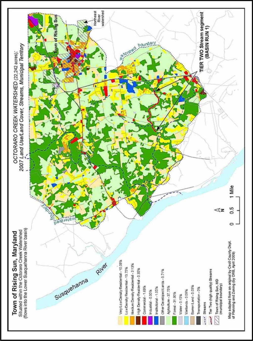
85 Attachment A 85
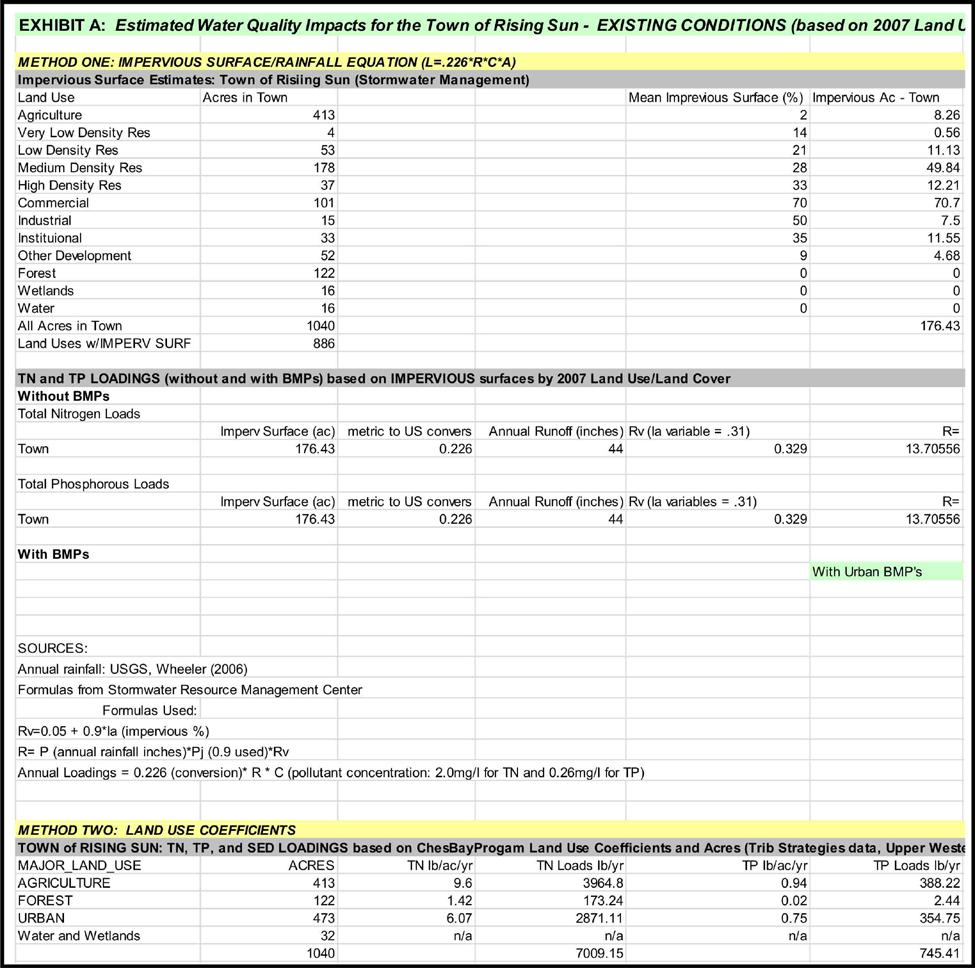
86 Attachment B 86
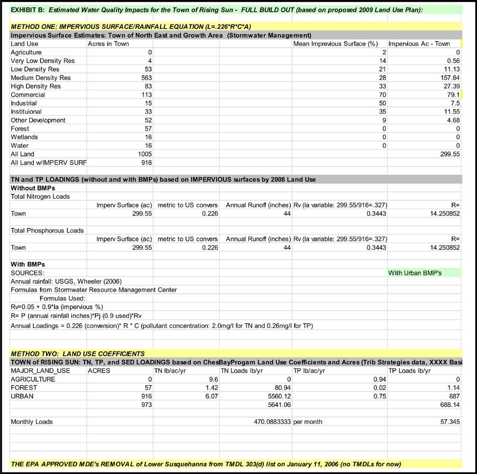
87 Attachment C 87
88 Attachment D 88
89 Attachment E 89
90 90
91 Chapter 7 Natural Resource Conservation and Sensitive Areas Protection INTRODUCTION The impact of growth and development on the natural resources and environmental quality of the area an issue of increasing public concern. Cecil County is blessed with an abundance of valuable natural resources which contribute to the County's pleasant quality of life. The effects of increased population and physical development can manifest themselves on the natural environment in many ways including: Clearing of trees and natural vegetation; Loss of plant and wildlife habitats and populations; Loss of limited farmlands; Loss of important wetlands and aquatic habitats; Contamination of groundwater for drinking supplies; Reduced surface water quality in streams, rivers and the Bay; Disruption of natural water drainage systems; Increased air pollution; Increased amounts of solid wastes and litter; and Loss of scenic natural views. Environmental deterioration does not have to be an inevitable consequence of growth and development. The construction of the new homes, businesses, industries, schools and roads necessary to accommodate growth can occur without unduly threatening the area's environmental quality if steps are taken to ensure that new development is designed and implemented in an environmentally-sensitive manner. Throughout the Town there are areas that are much more susceptible to environmental degradation than others due to the presence or proximity of sensitive natural features. Future development should be directed away from sensitive areas and guided towards areas where environmental impacts would be less severe. Regardless of location, all future development should be subject to minimum performance standards for environmental protection and natural resource conservation. OBJECTIVES To help insure the protection of natural resources, the Town has established the following objectives: 91
92 To protect water quality and wildlife and to conserve those natural features that make a significant contribution to the character of each zone and the Town in general. To limited development in floodplains, steep slopes, and other sensitive natural areas to protect natural resources. To protect water quality by reducing pollution and its effects, whatever the sources; To conserve fish, wildlife and plant habitats; To establish new protection measures for sensitive areas including streams and their buffers, IOO-year floodplains, steep slopes adjacent to streams, and habitats of threatened and endangered species to reinforce existing regulatory protection programs. To conserve forest and woodland resources and, wherever possible, replenished them through tree conservation measures and replanting programs and compliance with the Maryland Forest Conservation Act. To limit development within the 100-year floodplain so as to minimize disturbance and protect life and property. To coordinate with the Maryland Department of Natural Resources and the U. S. Department of Interior in the protection of rare, threatened, and endangered species habitat. To require evidence of Federal and State environmental permits as a condition of local development approval. To develop local regulations which ensure that the landscape be preserved in its natural state, insofar as practical, by minimizing tree and soil removal. To insure that all new development and redevelopment minimizes pollutant loadings and runoff from the site through the implementation of sediment, stormwater and erosion control plans. To encourage property owners to place environmentally sensitive lands under conservation easements through national, regional, State and local land trust organizations. To assure that proper stormwater management and sediment and erosion controls are enforced in accordance with the Stormwater Management Ordinance. Reduce conflicts between incompatible uses. 92
93 SENSITIVE AREAS The Maryland Economic Growth, Resource Protection and Planning Act of 1992 added provisions to Article 66 B of the Annotated Code for the State of Maryland that require this Comprehensive Plan to contain a Sensitive Areas Element which describes how the Town will protect the following sensitive areas: Streams and stream buffers; 100-year floodplains; Habitats of threatened and endangered species; and Steep slopes. Performance standards that protect sensitive resource areas should be included in the Zoning Ordinance and Subdivision Regulations. These standards should establish minimum protection levels for stream valleys, wetlands, forests, wildlife habitats, and sensitive soils. Streams and Stream Buffers Streams and their buffers are important resources. Streams support recreational fishing and serve as spawning areas for commercial fish stock. Development near stream areas subject to flooding can result in the loss of life and property. Streams and their adjacent buffers are home to countless species of animals and plants and transport valuable nutrients, minerals and vitamins to rivers and creeks and, in turn, the Chesapeake Bay. The floodplains, wetlands, and wooded slopes along streams are important parts of the stream ecosystem. As development activity consumes large amounts of land, forest cover and natural vegetation along streams are diminished. The cumulative loss of open space and natural growth reduces the ability of remaining land along streams to buffer the effects of greater storm water runoff, sedimentation, and higher levels of nutrient pollution. Buffers serve as protection zones when located adjacent to streams and reduce sediment, nitrogen, phosphorous, and other runoff pollutants by acting as a filter, thus minimizing stream damage. The effectiveness of buffers to protect stream water quality is influenced by their width (which should take into account such factors as contiguous or nearby slopes, soil erodibility, and adjacent wetlands or floodplains), the type of vegetation within the buffer (some plants are more effective at nutrient uptake than others), and maintenance of the buffer. Buffers also provide habitat for wetland and upland plants which form the basis of healthy biological communities. A wide variety of animals use the natural vegetation as a corridor for food and cover. A natural buffer system provides connections between remaining patches of forest in the area to support wildlife movement. 93
94 100-Year Floodplains Some areas are subject to periodic flooding which pose risks to public health and safety, and potential loss of property. Flood losses and flood-related losses are created by inappropriately located structures which are inadequately elevated or otherwise unprotected and vulnerable to floods or by development which increases flood damage to other lands or development. While protection of life and property provided the initial basis for protection of floodplains, there has been a growing recognition in recent years that limiting disturbances within floodplains can serve a variety of additional functions with important public purposes and benefits. Floodplains moderate and store floodwaters, absorb wave energies, and reduce erosion and sedimentation. Wetlands found within floodplains help maintain water quality, recharge groundwater supplies, protect fisheries, and provide habitat and natural corridors for wildlife. The minimum requirements of the National Flood Insurance Program do not prohibit development within the 100-year floodplain from development. However, to adhere to the minimum Federal requirements the Town requires development and new structures in the floodplain to meet certain flood protection measures including elevating the first floor of structures a minimum of one foot above 100-year flood elevations and utilizing specified flood proof construction techniques. Moreover, where alternative building sites on a parcel are available for construction outside the 100-year floodplain, then construction in the floodplain is prohibited. These requirements are established in the Town's Floodplain Management Ordinance. Habitats of Threatened and Endangered Species Materials and chemicals produced by plants and animals are a largely unresearched storehouse for products beneficial to people. More than half of all medicines in use today can be traced to wild organisms. Plant chemicals are the sole or major ingredient in 25 percent of all prescriptions written in the United States each year. Likewise, agriculture depends on the development of new varieties of crops, often created by cross-breeding strains with wild relatives of crop species, in efforts to develop pest, disease, or drought resistant crops. Maintenance of biological diversity today sustains future opportunities to advance health care and provide a number of other societal benefits. Habitat destruction and degradation is currently estimated to threaten some 400 native Maryland species with extinction. The key to protecting threatened and endangered species is protecting the habitat in which they exist. The Maryland Nongame and Endangered Species Conservation Act (Natural Resources Article, 10-2A-0 1 through 06) provides definitions of threatened and endangered species. Maryland law and regulations do not currently provide a definition of habitat. As a basis for establishing protection measures for habitats of threatened and endangered species, habitat is defined in this Plan as "areas which, due to their physical or biological features, provide important elements for the maintenance, expansion and long-term survival of threatened and endangered species listed in COMAR Such areas may include breeding, feeding, resting, 94
95 migratory, or overwintering areas". Steep Slopes Rising Sun Comprehensive Plan 2010 Slopes provide an environment that facilitates movement of soil and pollutants when land disturbances occur. Control of erosion potential is usually achieved through regulation of development on steep slopes because such areas represent the greatest opportunity for accelerated soil loss and resultant sedimentation and pollution to streams. Forest Conservation Act The Forest Conservation Act of 1991 (Natural Resources Article Sections ) was enacted to protect the forests of Maryland by making forest conditions and character an integral part of the site planning process. It is regulated by the Maryland Department of Natural Resources, but implemented and administered by local governments. The Forest Conservation Act seeks to maximize the benefits of forests and slow the loss of forest land in Maryland, while allowing development to take place. IMPLEMENTATION RECOMMENDATIONS This section of the Plan recommends performance standards that implement three important goals of the Comprehensive Plan dealing with protection of natural resources management of stormwater quality, and avoiding conflicts between adjacent land uses. These performance standards should apply to all new development in the town. Additional performance standards should be required for new development adjacent to publicly owned sensitive natural resource areas and private conservation areas. SENSITIVE AREAS PROTECTION Perennial Streams -A 110 foot minimum setback from all perennial streams, as shown on U.S.G.S. 7.5 minute quadrangle maps, shall be required for any disturbance except road crossing and recreational access to the stream. Ephemeral Streams -A 25 foot minimum setback from all ephemeral streams as identified on the U.S.O.S. 7,5 minute quadrangle maps is recommended for any disturbance except road crossing. Sensitive Soil Setback -There should be no disturbance of sensitive soils adjacent to the 110 foot perennial stream setback to a maximum distance of 160 feet. Sensitive areas should include hydric soils, floodplains, steep slopes, highly erodible soils, and highly permeable soils. Nontidal Wetlands -There should be at least a 25 foot setback from nontidal wetlands. No direct or indirect disturbance to nontidal wetlands should be permitted except as allowed by State and Federal nontidal wetland regulations. 95
96 Vegetated Buffer in Stream and Nontidal Wetland Setbacks -Vegetation in the perennial stream and nontidal wetlands setbacks should be preserved and maintained in a natural state, or if not present, created through planting of native species appropriate to the site. Steep Slopes (Outside stream valleys) -There should be no structures or impervious surfaces placed on slopes greater than 25 percent. On slopes between 15 and 25 percent good engineering practices should be used for sediment and erosion control during construction, and slopes should be stabilized as soon after disturbance as possible. Habitats of Rare, Threatened and Endangered Species -Rare, threatened and endangered species and their habitats should be protected as prescribed by Maryland DNR, Natural Heritage *Program. Where an appropriate situation presents itself for passive recreation, the Planning Commission may require that open space on an applicant site, or on another site purchased for open space, be afforested to improve wildlife habitat and to provide passive recreational opportunities. Forest Cover Protection -All land development should be required to limit clearing of natural vegetation and retain specimen trees to the extent possible, as determined by a forest stand delineation study and in accordance with the Forest Conservation Ordinance of the Town of Rising Sun. Floodplain Protection -All areas within a designated Floodplain or zoned F-l, shall be subject to the Town of Rising Sun Floodplain Ordinance as approved by F.E.M.A. Stormwater Management Creation of Impervious Surfaces -All land development should be encouraged to minimize impervious surfaces through good site design, use of impervious surfaces where use by people or vehicles is infrequent, and full utilization of height limits on structures. Bufferyards Bufferyards are meant to minimize the negative impacts of adjacent incompatible uses. Buffering can be achieved by a combination of setbacks and vegetative plantings. Such vegetative plantings shall be of a type that remains thick with foliage all year such as evergreens, pines, etc. Guidelines -Bufferyards should be required along property boundaries between all zones of disparate intensities. Road buffers should be wide enough to screen residential areas from the road. Road buffers should be wider along with more traffic. Finally, bufferyards should be required along property boundaries between agricultural and residential uses. Street trees along the road satisfy bufferyard guidelines along internal roads. Bufferyards are a design technique that can be employed to achieve some of the objective of 96
97 the Comprehensive Plan. The following discusses two types of bufferyards that can be considered by the Planning Commission. The first is the bufferyard between zoning districts and the second is the bufferyard between development and roads. Bufferyards are a combination of setback together with the planting required thereon. Both the amount of land (setback) and the type and amount of planting for each bufferyard are specified and are designed to ameliorate nuisances between adjacent zoning districts and to insure a desired character along public streets and roads. One of zoning's most important functions is the division of land uses into districts which have similar character and contain compatible uses. All uses permitted in any zoning district have generally similar nuisance characteristics. Bufferyards between zoning districts act to minimize the negative impact of any future use on neighboring uses. They separate different zoning districts from each other in order to eliminate or minimize potential nuisances such as dirt, litter, noise, glare of lights, signs, and unsightly buildings or parking areas, or to provide spacing to reduce adverse impacts of noise, odor, or danger from fires or explosions. Bufferyard can also be required along roads to maintain and enhance visual character area. Public perception of community character is most commonly experienced moving along public roads. Where appropriate, the Planning Commission may agree that it is more desirable to leave openings in bufferyards to permit views of scenic areas or over open space areas. Street Trees A new awareness of the importance of streets to the quality of life in our growth centers is needed. We must plan for streets that are pleasant to walk along. Development can and should create an exciting, attractive and vibrant community. New concepts -using the successful communities of our past -should be permitted, encouraged and preferred. As part of this philosophy, street tree planting should be required and specimen trees should be saved where possible. The Town should require that street trees be planted or retained along both sides of all newly created streets. All plantings should be done in conformance with the Forest Conservation Ordinance. At a minimum developers should be required either plant or retain sufficient trees so that for every 35 feet of street frontage there is at least an average of one deciduous tree that has or will have when fully mature a trunk at least 12 inches in diameter. Chapter 8 Mineral Resources No known deposits of commercially viable mineral resources (such as construction grade sand and gravel) exist within the Town or Rising Sun or the areas contemplated for growth and potential annexation. If such deposits are located in the future, the Town will adopt appropriate policies in accordance with the requirements of Article 66B to ensure that such deposits are protected for purposes of utilization prior to premature site development. 97
98 Chapter 9 Community Facilities INTRODUCTION Rising Sun Comprehensive Plan 2010 The quality and location of recreation areas, governmental services schools and libraries in the Rising Sun area are as important to the town's continued well being as its places of employment, homes and circulation system. They contribute to the health and vitality of its citizens and have a significant effect on the quality of life in Rising Sun. For these reasons, it is important that the Town's facilities and services keep pace with its growth and patterns of local need. The goals, policies and recommendations in this section have been developed as interrelated parts of the proposed land use and circulation plans presented in the previous sections. The various elements of the Towns Community Facilities Plan are presented below under separate subheadings for ease in presentation. OPEN SPACE AND RECREATION Open Space and Recreation Objectives To establish local parks within easy access of Rising Sun s present and future residents To link centers of community activity through park systems To Provide for an Open Space system of sufficient size and locational qualities to meet the complete range of recreation activities To establish and improve the quantity and quality of local parks within easy access of all present and future residents implies a recommended policy approach to park and recreational development programs. A first step in developing a coordinated approach to development is the establishment of desired open space and recreation standards. The application of these standards will aid in determining future open adequacy. Figure 2 indicates the open space planning standards recommended. Within this suggested framework, a balanced park and recreational system can be developed. Future park land acquisition can be evaluated as to their ultimate benefits as well as to their immediate effectiveness. Based on the standards presented above, Figure 3 indicates the number of needed facilities based on the present and future population. 98
99 Play Lot Tot Lot Facility Equipment Age Groups Served Neighborhood Playground/Park Community Recreation Area Swings, Slides, Structures, Sand Boxes, Fences and Benches Swings, slides, Baseball fields, Basketball courts, play lots Playground Equipment, Sports Fields, Areas for passive recreation, toilets, indoor recreation, pools, tennis Table 9-1 General Recreation Standards Optimum Size 2-6 years 1,500 to 5,000 sq. ft years 2-7 acres All acres or larger Acres per 1,000 pop. Population (at 4 persons per household 1.5 to to ,500 6,000 to 15,000 Service Area 1/8 to ¼ mile (dependent on density) ½ mile 1 ½ to 3 miles Time Frame/ Area Table 9-2 Present and Future Needs by Type of Recreation Facility Population Tot Lots Acres Acres 1/200 Needed Needed persons 99 Neighborhood Parks 1/500-1,500 persons Community Parks 1/6,000 15,000 persons Acres Needed Present/Town Future/Town 1, Future/Area 9, acres + The figures indicated that at present the Town is deficient in the number of tot lots, neighborhood playgrounds and other types of recreational facilities available to its population. With the growth expected in the area, it would be to the benefit of the Town to start acquiring areas suitable for each recreational need. The construction of multi-purpose recreation center just south of Rising Sun will aid in meeting the recreational deficiency which presently exists. Unlike many municipalities, the Town has ample vacant land on which proposed recreational facilities could be located. The abundant number of streams and valleys can serve duel purposes both for preservation as well as providing areas for recreational activity. The area in
100 the northeast quadrant of Town should be consider for park area and may also serve as a stormwater management area and reservoir. Map 4 illustrates the major proposed Open Space and Recreational Plan for the Town. As is indicated on Map 4, all proposed residential areas are within ½ -1 mile distance to the proposed steam valley lands which gives residents easy access to recreational facilities and pedestrian paths which may be planned along these water courses thus meeting the plan objectives. Listed below are the major open space and recreational recommendations: 1 Encourage stream valleys be preserved for open space and recreational use. 2 Provide tot lots throughout the Town in strategically located vacant areas. 3 Acquire land for additional neighborhood playgrounds to supplement the Little League Field as well as to serve future populations in the Town. 4 Develop the existing abandoned railroad right-of-way as pedestrian and bicycle path to link major open spaces. In order to implement the Open Space and Recreation objectives for the Town, all residential subdivisions should be required to provide recreation opportunities. The Town may require that all residential developments in the Town shall provide, at a minimum, (through dedication or reservation) recreational areas in the form of neighborhood parks at the rate of acres per residential unit, with a minimum area of not be less than 5,000 square feet. The Town Commissioners may permit payment of a fee in-lieu, dedication, reservation or a combination whenever these open space requirements cannot adequately meet the open space and recreation responsibilities of the development or if the development is less than 30 homes or within 1,500 feet from another park or playground. The fee in-lieu should be on a per-dwelling unit basis as established by the Town. Fees collected should be deposited only in a designated account with funds expended only for planned park and recreation facilities. In the case of large proposed developments (over 100 dwelling units) the Planning Commission may require a combination of improved park and recreational property and playgrounds, at the minimum rate of acre per dwelling unit, and an impact fee in order to meet the planned Town open space and recreation objectives. 100
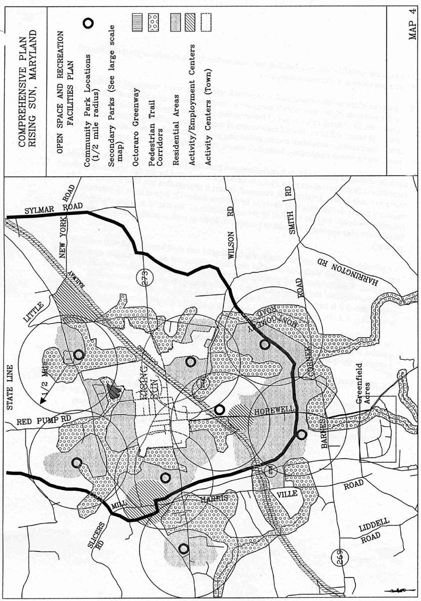
101 101
CHAPTER 12 IMPLEMENTATION
 CHAPTER 12 IMPLEMENTATION The 2010 Town of Denton Comprehensive Plan is intended to capture a vision of the future of Denton. As such, it provides a basis for a wide variety of public and private actions
Town of Peru Comprehensive Plan Executive Summary
 Town of Peru Comprehensive Plan Executive Communities that plan grow by choice, not by chance. A plan makes growth thoughtful, understandable, and predictable. A plan shows that a community is managing
Proposed Comprehensive Plan Strategies DRAFT for discussion June 28, 2017
 Proposed Comprehensive Plan Strategies DRAFT for discussion June 28, 2017 Land Use Rural Areas Refine the Farm and Forest area (FF) Update FF boundaries to account for existing lots less than five acres
Hockessin Community Redevelopment Plan
 Hockessin Community Redevelopment Plan 3.1 Introduction The Community Redevelopment Plan for the Village of Hockessin is the result of the people s vision for a distinct village center that serves as the
NEW CASTLE COUNTY S ZONING DISTRICTS
 NEW CASTLE COUNTY S ZONING DISTRICTS This is general information about New Castle County s zoning districts. The information included is by no means exhaustive or complete. Before designing plans to develop
4.1.3 LAND USE CATEGORIES
 4.1.3 LAND USE CATEGORIES a. City Center District The City Center District incorporates the existing character and mix of uses in downtown Belmont to encourage redevelopment and new development in keeping
COMMUNITY DESIGN. GOAL: Create livable and attractive communities. Intent
 COMMUNITY DESIGN Intent An attractive, well-designed County will attract quality development, instill civic pride, improve the visual character of the community, and create a strong, positive image for
This page intentionally blank.
 This page intentionally blank. Parks, Recreation, and Open Space Chapter Relationship to Vision Vision Parks, Recreation and Open Space Chapter Concepts County Government. County government that is accountable
PSRC REVIEW REPORT & CERTIFICATION RECOMMENDATION
 PSRC REVIEW REPORT & CERTIFICATION RECOMMENDATION KITSAP COUNTY COUNTYWIDE PLANNING POLICIES July 2, 2012 BACKGROUND A major emphasis of the Washington State Growth Management Act (GMA) is the need to
Chapter IV: Development Pattern
 Chapter IV: Development Pattern Introduction The 2002 Prince George s County Approved General Plan designates three growth policy tiers Developed, Developing, and Rural as well as three center designations
INTRODUCTION PLANNING HISTORY
 INTRODUCTION The Upper Rock Creek Master Plan Area lies in the east central part of Montgomery County. The Master Plan Area is adjacent to the City of Rockville to the south, the Olney Planning Area to
Living in Albemarle County s Urban Places
 Living in Albemarle County s Urban Places ALBEMARLE COUNTY, VIRGINIA A Closer Look at Albemarle s Approach to Managing Growth and Creating Quality Urban Environments www.albemarle.org Page 2 Living in
LAND USE ELEMENT. Purpose. General Goals & Policies
 LAND USE ELEMENT Purpose This Land Use Element contains the goals and policies necessary to support the City s responsibility for managing land resources and guiding development through implementing regulations,
Implementation Guide Comprehensive Plan City of Allen
 Implementation Guide 2030 Comprehensive Plan City of Allen DRAFT 2015 Implementation Guide Allen 2030 Comprehensive Plan INTRODUCTION The Comprehensive Plan serves as a guide for the growth and development
The transportation system in a community is an
 7 TRANSPORTATION The transportation system in a community is an important factor contributing to the quality of life of the residents. Without a sound transportation system to bring both goods and patrons
2018 Northampton Township Comprehensive Plan
 2018 BUCKS COUNTY, PENNSYLVANIA What is a? A comprehensive plan is a municipality s main policy document that details the collective vision for the future, the historic, environmental, and cultural facilities
The Five Components of the McLoughlin Area Plan
 The Five Components of the McLoughlin Area Plan This documents contains the complete language of the five components of the McLoughlin Area Plan: The Vision Statement The Values The Guiding Principles
CHAPTER 3 VISION, GOALS, & PLANNING PRINCIPLES. City of Greensburg Comprehensive Plan. Introduction. Vision Statement. Growth Management Goals.
 CHAPTER 3 VISION, GOALS, & PLANNING PRINCIPLES Introduction The Greensburg Comprehensive Plan is intended as a working community document. A combination of long and short-term goals, this document is intended
2030 Comprehensive Plan VISION STATEMENT
 RESOURCE DOCUMENT for Steering Committee Meeting #2 July 12, 2017 2030 Comprehensive Plan VISION STATEMENT Steering Committee from 2008 Established the Lauderdale s Vision as: Creating a livable, lovable
2040 LUP is a part of the Comprehensive Plan and carries the same legal authority. Economic Challenges
 1.1. Guiding Anchorage s Growth Where will new residents settle over the next two decades? Where will people work, shop, and play? Will there be enough room to grow? How will Anchorage look? Will growth
CHAPTER 1: INTRODUCTION
 CHAPTER 1: INTRODUCTION MAP OF OUTAGAMIE COUNTY, WI N 1 = 6 miles INTRODUCTION The Town and Village of Black Creek are located in central Outagamie County, Wisconsin. The Village is located in the north
CITY OF PUYALLUP. Background. Development Services
 CITY OF PUYALLUP Development Services 333 South Meridian Puyallup WA 98371 To: City Council From: Katie Baker, AICP, Planning Division Re: South Hill Neighborhood Plan Adoption Date: (Meeting date: February
Hibbing. Land Use. Hibbing Comprehensive Plan 8.1. Land Use
 Hibbing 8.1 Introduction 8.3 Information and Assessment 8.5-8.14 Recommendations 8.15-8.17 Implementation 8.18-8.19 8.2 Introduction Although land use was not identified as a discrete goal during the community
Ten Mile Creek Planning Area
 PLANNING AREA POLICIES TEN MILE CREEK Ten Mile Creek Planning Area Location and Context The Ten Mile Creek Planning Area ( Ten Mile Creek area ) is located south of the current Boise AOCI, generally south
EXHIBIT A. Tax Increment Reinvestment Zone No. 1 (Town Center) First Amended Project Plan 1
 First Amended Project Plan 1") EXHIBIT A Tax Increment Reinvestment Zone No. 1 (Town Center) First Amended Project Plan 1 1 As amended by Resolution No. 2008-02-001(TR1R) of the Tax Increment Reinvestment Zone No.1, and approved to
EXHIBIT A Tax Increment Reinvestment Zone No. 1 (Town Center) First Amended Project Plan 1 1 As amended by Resolution No. 2008-02-001(TR1R) of the Tax Increment Reinvestment Zone No.1, and approved to
Silverdale Regional Center
 Silverdale Regional Center Vision for Silverdale Regional Center The Silverdale Regional Center Plan (Plan) will guide the evolution of the Silverdale Regional Center from a collection of strip malls and
Chapter 2: Vision, Goals and Strategies
 Chapter 2: Vision, Goals and Lake Elmo Today & Tomorrow Comprehensive Plan 2040 2 VISION, GOALS & STRATEGIES - DRAFT 4-6-2018 INTRODUCTION Comprehensive Plan Purpose Perhapse the most important objective
Access Management: An Overview
 Figures 1-5 Below Evolution of development along a highway. In the early stages, land along the road is used for farming with little traffic generated. As time passes, the highway corridor becomes a de
CHAPTER 1. Ms. Guajardo s Class - Central Elementary CH 1 1
 INTRODUCTION CHAPTER 1 Ms. Guajardo s Class - Central Elementary CH 1 1 1.1 SETTING South Centre City is a linear corridor south of Downtown Escondido paralleling Centre City Parkway and South Escondido
SUMMERSIDE / MT. CARMEL REINVESTMENT CORRIDOR COMMUNITY DEVELOPMENT STRATEGY
 SUMMERSIDE / MT. CARMEL REINVESTMENT CORRIDOR COMMUNITY DEVELOPMENT STRATEGY FEBRUARY 2013 I. Location of the Summerside/Mt. Carmel Reinvestment Corridor The Summerside/Mt. Carmel Reinvestment Corridor
VILLAGE OF CLEMMONS PLANNING BOARD DRAFT STAFF REPORT
 VILLAGE OF CLEMMONS PLANNING BOARD DRAFT STAFF REPORT PETITION INFORMATION Docket # C-226 Staff Megan Ledbetter Petitioner(s) JBJH Properties, LLC Owner(s) JBJH Properties, LLC Subject Property 5892-49-1766
SECTION II SECTION II STATEMENT OF GOALS, OBJECTIVES, PRINCIPLES, ASSUMPTIONS, POLICIES AND STANDARDS
 STATEMENT OF GOALS, OBJECTIVES, PRINCIPLES, ASSUMPTIONS, POLICIES AND STANDARDS 1 2 STATEMENT OF GOALS, OBJECTIVES, PRINCIPLES, ASSUMPTIONS, POLICIES AND STANDARDS INTRODUCTION The New Jersey Municipal
Official Plan Review
 Official Plan Review Summary Report - The Built Environment August 2014 Part 1: Introduction Planning for a healthy, prosperous and sustainable community is an important goal for our municipality. From
13 THORNHILL YONGE STREET STUDY IMPLEMENTATION CITY OF VAUGHAN OPA 669 AND TOWN OF MARKHAM OPA 154
 13 THORNHILL YONGE STREET STUDY IMPLEMENTATION CITY OF VAUGHAN OPA 669 AND TOWN OF MARKHAM OPA 154 The Planning and Economic Development Committee recommends the adoption of the recommendations contained
Joint Meeting City Council and the Plan Commission. September 1st, 2015
 Joint Meeting City Council and the Plan Commission September 1st, 2015 1 The City Plan Commission shall recommend a City Plan for the physical development of the City Article IX Section 2 of the City of
What s in a Name Sustainability, Smart Growth, New Urbanism
 What s in a Name Sustainability, Smart Growth, New Urbanism Published in the Summer 2011 Issue of APA s The Commissioner Pete Pointner FAICP Planning commissioners frequently hear abstract terms bantered
Outlawing Sprawl. Pennsylvania Chapter American Planning Association October 6, 2009
 Outlawing Sprawl Pennsylvania Chapter American Planning Association October 6, 2009 Presented by: Ronald T. Bailey, AICP Executive Director Chester County Planning Commission Location: 2009 PA Chapter
4-Town Comprehensive Plan DRAFT 7/30/07
 4-Town Comprehensive Plan DRAFT 7/30/07 Acknowledgements ning Committee Town of Harrisburg Norman Roof Randy Nicol Town of Martinsburg Terry Thisse Paul Kelly Town of Montague Jan Bagdanowicz Wendy Perry
Guiding Principles, Objectives, Strategies and Policies
 Guiding Principles, Objectives, Strategies and Policies Section 1 Introduction These Guiding Principles were adopted as part of the 1999 Athens-Clarke County Comprehensive Plan and are carried over, in
3. VISION AND GOALS. Vision Statement. Goals, Objectives and Policies
 Vision Statement Queen Creek s interconnected network of parks, trails, open spaces and recreation opportunities provide safe and diverse activities and programs that sustain its unique, small town, equestrian
EXISTING COMPREHENSIVE PLAN
 EXISTING COMPREHENSIVE PLAN Town Center Land Use Element: V. LAND USE POLICIES Town Center Mercer Island's business district vision as described in "Your Mercer Island Citizen-Designed Downtown" was an
CHAPTER 7: Transportation, Mobility and Circulation
 AGLE AREA COMMUNITY Plan CHAPTER 7 CHAPTER 7: Transportation, Mobility and Circulation Transportation, Mobility and Circulation The purpose of the Transportation, Mobility and Circulation Chapter is to
E. RURAL COMMERCIAL/INDUSTRIAL PARK MODEL
 E. RURAL COMMERCIAL/INDUSTRIAL PARK MODEL 1. PURPOSE The purpose of the Rural Commerce/Industrial Park Model is to provide parameters within which a grouping of business buildings with parking, loading
EXECUTIVE SUMMARY DRAFT CHAPTER 1 INTRODUCTION EXECUTIVE SUMMARY
 CHAPTER 1 EXECUTIVE SUMMARY INTRODUCTION Through the joint efforts of the City of Tulsa planning staff and the Land Services division of Indian Nations Council of Governments (INCOG), the Berryhill Land
6 Growth Management Challenges and Opportunities
 6 Growth Management Challenges and Opportunities The Town has established a goal of attaining a 50% participation rate with respect to employment opportunities versus residential population. The Town s
Ivywild On The Creek PRELIMINARY CREEK DISTRICT MASTER PLAN
 Ivywild On The Creek PRELIMINARY CREEK DISTRICT MASTER PLAN Introduction: Rejuvenating an extraordinary Creekside neighborhood THE CREEKSIDE DISTRICT The Ivywild On The Creek Neighborhood District Master
DISCUSSION TOPIC: ST JOHNS RIVER & ITS TRIBUTARIES (BPII) 2030 COMPREHENSIVE PLAN POLICES AND REGULATORY FRAMEWORK
 2030 COMPREHENSIVE PLAN POLICES AND REGULATORY FRAMEWORK") DISCUSSION TOPIC: ST JOHNS RIVER & ITS TRIBUTARIES (BPII) 2030 COMPREHENSIVE PLAN POLICES AND REGULATORY FRAMEWORK St. John s River & Its Tributaries Issue Summary: The St. Johns River is an important
DISCUSSION TOPIC: ST JOHNS RIVER & ITS TRIBUTARIES (BPII) 2030 COMPREHENSIVE PLAN POLICES AND REGULATORY FRAMEWORK St. John s River & Its Tributaries Issue Summary: The St. Johns River is an important
ARTICLE 6: Special and Planned Development Districts
 ARTICLE 6: Special and Planned Development Districts 6-10 Traditional Neighborhood Development (TND) District 6-10.10 Purpose and Intent The Traditional Neighborhood Development (TND) District provides
Planning & Zoning Commission Staff Report
 Planning & Zoning Commission Staff Report Meeting Date: May 26, 2015 Drafted by: Katherine Harrison-Rogers CASE # Z2886 PROJECT NAME: APPLICANT/ REPRESENTATIVE: Shawna Runyan PROPERTY OWNER: 1840 (previously
Planned Development Review Revisions (Project No. PLNPCM )
") Planned Development Review Revisions (Project No. PLNPCM2014-00139) Standard residential development Planned Development Example: Smaller lot sizes than what is allowed to create open space amenity. What
Planned Development Review Revisions (Project No. PLNPCM2014-00139) Standard residential development Planned Development Example: Smaller lot sizes than what is allowed to create open space amenity. What
Gold Line Bus Rapid Transit Transit Oriented Development (BRTOD) Helmo Station Area Plan
 Helmo Station Area Plan") Appendix F Gold Line Bus Rapid Transit Transit Oriented Development (BRTOD) Helmo Station Area Plan Introduction and Purpose of the Plan The Gold Line Bus Rapid Transit facility is an eleven-mile dedicated
Appendix F Gold Line Bus Rapid Transit Transit Oriented Development (BRTOD) Helmo Station Area Plan Introduction and Purpose of the Plan The Gold Line Bus Rapid Transit facility is an eleven-mile dedicated
Land Use Amendment in Southwood (Ward 11) at and Elbow Drive SW, LOC
 at and Elbow Drive SW, LOC") 2018 November 15 Page 1 of 10 EXECUTIVE SUMMARY This land use amendment application was submitted by Rick Balbi Architect on 2017 August 31 on behalf of Sable Developments Ltd, and with authorization from
2018 November 15 Page 1 of 10 EXECUTIVE SUMMARY This land use amendment application was submitted by Rick Balbi Architect on 2017 August 31 on behalf of Sable Developments Ltd, and with authorization from
Improve Neighborhood Design and Reduce Non Point Source Water Pollution
 HOW TO Planning Guide Improve Neighborhood Design and Reduce Non Point Source Water Pollution This document was funded by a grant from the New Hampshire Coastal Program with funding from the National Oceanic
9 CITY OF VAUGHAN OFFICIAL PLAN AMENDMENT NO BOCA EAST INVESTMENTS LIMITED
 9 CITY OF VAUGHAN OFFICIAL PLAN AMENDMENT NO. 631 - BOCA EAST INVESTMENTS LIMITED The Planning and Economic Development Committee recommends the adoption of the recommendations contained in the following
Chapter 10 IMPLEMENTATION RECOMMENDATIONS
 Chapter 10 IMPLEMENTATION RECOMMENDATIONS The recommended land use plan presented in the previous chapter provides a design for the attainment of the urban and rural development and open space preservation
TRANSPORTATION AND LAND USE
 CHAPTER 10 TRANSPORTATION AND LAND USE Transportation and land use are intimately linked. The expansion of a highway typically spurs housing, employment growth and land development in the communities that
IV. Development in the Rural Overlay District
 Intracoastal Waterway Route 17 Route 168 Great Dismal Swamp VIRGINIA NORTH CAROLINA IV. Development in the Rural Overlay District IV-1 Route 17 in Chesapeake s Rural Overlay District affords distant views
Section 9 NEIGHBORHOOD DESIGN
 Section 9 NEIGHBORHOOD DESIGN City of Lancaster Comprehensive Plan D u n k i n, S e f k o & A s s o c i a t e s, I n c. NEIGHBORHOOD DESIGN INTRODUCTION There are many ways in which a neighborhood can
Town of Washington Master Plan & Regulatory Audit: Interim Results
 Town of Washington Master Plan & Regulatory Audit: Interim Results May 20, 2008 Presented by: 30 Bank Street Lebanon, NH 03766 www.uvlsrpc.org Introduction & Purpose Compare the Master Plan to the regulations
SECTION ONE: INTRODUCTION. introduction
 introduction 1 INTRODUCTION Since it was first established in 1843 as a trading post for the Hudson s Bay Company, Victoria has evolved into a Provincial capital city that is recognized across Canada and
3 Vision and Goals. Vision and Goals. Blueprint for Bloomsburg. Vision. Town of Bloomsburg Comprehensive Plan,
 Vision and Goals 3 Vision and Goals Citizens of the Town of Bloomsburg clearly value their natural and cultural heritage, the walkable, mixed use pattern of downtown, the access to education, and the community
Woodburn Comprehensive Plan Growth Management Goals and Policies
 Goal Woodburn Comprehensive Plan Growth Management Goals and Policies G-1. The City's goal is to manage growth in a balanced, orderly and efficient manner, consistent with the City s coordinated population
Plan Overview. Manhattan Area 2035 Reflections and Progress. Chapter 1: Introduction. Background
 Plan Overview The Manhattan Urban Area Comprehensive Plan (the Comprehensive Plan) is a joint planning initiative of the City of Manhattan, Pottawatomie County, and Riley County. The 2014 Comprehensive
Staff Report and Recommendation
 Community Planning and Development Planning Services 201 W. Colfax Ave., Dept. 205 Denver, CO 80202 p: 720.865.2915 f: 720.865.3052 www.denvergov.org/cpd TO: City Council Neighborhoods and Planning Committee
CHAPTER 7: VISION AND ACTION STATEMENTS. Noble 2025 Vision Statement
 CHAPTER 7: VISION AND ACTION STATEMENTS This chapter presents the vision, policy and action statements that transform the comprehensive planning study, an analysis of Noble s past, future trends and community
A BLUEPRINT FOR BROCKTON A CITY-WIDE COMPREHENSIVE PLAN
 A BLUEPRINT FOR BROCKTON A CITY-WIDE COMPREHENSIVE PLAN Public Meeting October 2016 1 Plan Summary and Discussion Public Meeting May 4 2017 City of Brockton Bill Carpenter, Mayor Department of Planning
RECREATION AND OPEN SPACE ELEMENT GOALS, OBJECTIVES, AND POLICIES
 RECREATION AND OPEN SPACE ELEMENT GOALS, OBJECTIVES, AND POLICIES Goal 7 To provide park facilities, recreation programs, and open space resources that are safe, adequate, and accessible to all City residents,
Gloucester County s Comprehensive Plan. The Community Connection
 Gloucester County s Comprehensive Plan The Community Connection Current Comp Plan Adopted in 1991 with a 20 year planning horizon Updated in 1995 with Part V- Implementation Recommendations and Appendix
CHAPTER 4 FUTURE LAND USE AND URBAN SERVICES DISTRICTS
 CHAPTER 4 FUTURE LAND USE AND URBAN SERVICES DISTRICTS Introduction This chapter discusses how Benzie County should grow and change in the future. A community can grow and change in many different ways.
DRAFT Amsterdam/Churchill Community Plan (4/17/08) Adopted By the Gallatin County Commission
 Adopted By the Gallatin County Commission") DRAFT Amsterdam/Churchill Community Plan (4/17/08) Adopted By the Gallatin County Commission Table of Contents Acknowledgements Chapter 1: Introduction A Brief History What s Next Authority Organization
DRAFT Amsterdam/Churchill Community Plan (4/17/08) Adopted By the Gallatin County Commission Table of Contents Acknowledgements Chapter 1: Introduction A Brief History What s Next Authority Organization
Secrest Short Cut and Monroe Expressway Small Area Plan AUGUST 29, 2018
 Secrest Short Cut and Monroe Expressway Small Area Plan AUGUST 29, 2018 Background and Process Monroe Expressway will be open by the end of 2018 Union County and Indian Trail identified a need to revisit
Westwind Developments Ltd. PIONEER LANDS AREA STRUCTURE PLAN - PROPOSED AMENDMENT
 FEBRUARY 2013 TABLE OF CONTENTS 1.0 BACKGROUND... 1 1.1 Amendment... 1 2.0 LOCATION & CONTEXT... 2 2.1 Land Ownership... 2 3.0 POLICY CONTEXT... 3 3.1 Municipal Development Plan... 3 3.2 Capital Region
3. ELEMENTS OF THE METRO VISION 2035 PLAN
 3. ELEMENTS OF THE METRO VISION 2035 PLAN What is Metro Vision and why does it matter? For more than 50 years, DRCOG has championed a regional perspective on key issues facing the metropolitan area and
Urban Fringe Subarea Plan
 Urban Fringe Subarea Plan Updated February 27, 2018 Table of Contents Page I. Existing Goals and Policy Framework 2 A. Growth Management Act (GMA) B. County-wide Planning Policies C. Whatcom County Comprehensive
CHAPTER 2: PLANNING PRINCIPLES
 CHAPTER 2: PLANNING PRINCIPLES 2 Comprehensive Principles The following overarching Principles provide the basis for the goals and policies included in the Mendocino County General Plan. These Principles
ELK GROVE GENERAL PLAN VISION
 2-1 CHAPTER 2: 2-2 CREATING OUR The Community Vision for Elk Grove, expressed through a Vision Statement and a series of Supporting Principles, is a declaration of the kind of community that Elk Grove
Concord Community Reuse Project Goals and Guiding Principles. Overarching Goals (OG)
") Concord Community Reuse Project Goals and Guiding Principles Overarching Goals (OG) No priority is implied by the order of presentation of the goals and guiding principles. Overarching goals for the Concord
Concord Community Reuse Project Goals and Guiding Principles Overarching Goals (OG) No priority is implied by the order of presentation of the goals and guiding principles. Overarching goals for the Concord
implementation10 Village of Greendale Comprehensive Plan: Greendale, Wisconsin. Revisiting a Greenbelt Community
 implementation10 Village of Greendale Comprehensive Plan: 2010 - Village of Greendale Comprehensive Plan: 2010 - Implementation The recommendations of this Plan must be implemented by the Village of Greendale,
The Vision. Photo provided by The Minervini Group. 46 Vision, Objectives & Strategies
 Vision, Objectives & Strategies The is the public framework and guide for future development of the Grand Traverse Commons. The establishes public polices for infrastructure, the preservation of natural
Urban Planning and Land Use
 Urban Planning and Land Use 701 North 7 th Street, Room 423 Phone: (913) 573-5750 Kansas City, Kansas 66101 Fax: (913) 573-5796 Email: planninginfo@wycokck.org www.wycokck.org/planning To: From: City Planning
Definitions. Average Daily Traffic Demand (ADT): The actual number or projected number of cars that pass a point in a 24-hour period.
: The actual number or projected number of cars that pass a point in a 24-hour period.") Definitions Access Management: A combination of physical techniques and transportation policies used to control the flow of traffic between roads and the surrounding lands. Alternative City Form Scenarios:
Definitions Access Management: A combination of physical techniques and transportation policies used to control the flow of traffic between roads and the surrounding lands. Alternative City Form Scenarios:
A Growing Community Rural Settlement Areas
 Town of Huntsville Official Plan Review - POLICY BACKGROUND PAPER A Growing Community Rural Settlement Areas BACKGROUND: In addition to the fully municipally-serviced Urban Settlement Area and the Hidden
CITY OF LANGLEY OFFICIAL COMMUNITY PLAN BYLAW, 2005, NO APPENDIX II - REGIONAL CONTEXT MAP
 CITY OF LANGLEY OFFICIAL COMMUNITY PLAN BYLAW, 2005, NO. 2600 APPENDIX II - REGIONAL CONTEXT MAP ± Legend Agricultural Mixed Employment Industrial Conservation & Recreation Regional City Centre Urban Containment
The following rules shall be used to determine the precise location of any zone boundary shown on the Official Zoning Map of Auburn:
 ARTICLE III. ESTABLISHMENT OF ZONING DISTRICTS Section 300. Establishment of Zoning Districts. The City of Auburn, Alabama is hereby divided into zoning districts of such number and character as are necessary
Sorted citizen input comments in review of Blount County plans July, August, and September 2007
 Sorted citizen input comments in review of Blount County plans July, August, and September 2007 The following presents sorted citizen input comments from three sessions held in July, August and September
In surveys, Dallas residents say what they want to change most
 NEIGHBORHOODS ELEMENT In surveys, Dallas residents say what they want to change most in the city is its appearance they want it to look beautiful, with trees and pedestrian-friendly neighborhoods. The
Executive Summary. NY 7 / NY 2 Corridor
 Executive Summary NY 7 / NY 2 Corridor Transportation and Land Use Study December 2005 Prepared for: Town of Colonie Capital District Transportation Committee Prepared by: Introduction: Land use decisions
Goals and Objectives. Chapter 5 GOALS AND OBJECTIVES. Historic, Cultural, Natural and Agricultural Resources
 Chapter 5 Goals and Objectives Goals are general statements indicating the desired direction for the communities and reflect the long-term state that they wish to establish or to maintain. Objectives are
TREASURE COAST REGIONAL PLANNING COUNCIL M E M O R A N D U M. To: Council Members AGENDA ITEM 5H
 TREASURE COAST REGIONAL PLANNING COUNCIL M E M O R A N D U M To: Council Members AGENDA ITEM 5H From: Date: Subject: Staff October 17, 2008 Council Meeting Local Government Comprehensive Plan Review Draft
Visioning Statement and Guiding Principles
 Visioning Statement and Guiding Principles Planning for the Future The General Plan The General Plan represents Woodland's shared vision of the future and defines a path to lead the community toward its
C. Westerly Creek Village & The Montview Corridor
 C. Westerly Creek Village & The VISION Community Vision When the goals of the city are achieved Westerly Creek Village, a distinctive community defined by Montview Boulevard and Westerly Creek, is a strong
Benzie County Master Plan: Priority Issues & Opportunities
 Benzie County Master Plan: Priority Issues & Opportunities From March 2015 through January 2016, Networks Northwest staff worked with the Benzie County Master Plan Committee to obtain input from the public
OVERVIEW OF PLANS FOR THE JEFFERSON COUNTY COUNTRYSIDE FARM In the Context of Quality Place Characteristics
 OVERVIEW OF PLANS FOR THE JEFFERSON COUNTY COUNTRYSIDE FARM In the Context of Quality Place Characteristics By Steve Grabow, Professor and Community Development Educator University of Wisconsin-Extension,
D-O LRT Zoning Discussion. Chapel Hill Boards & Commissions October 16, 2017
 D-O LRT Zoning Discussion Chapel Hill Boards & Commissions October 16, 2017 Update on Overall D-O LRT Station Area Initiative Objectives Design and educate on principles of Good Transit-Oriented Development
CITY OF CHARLOTTESVILLE, VIRGINIA CITY COUNCIL AGENDA
 CITY OF CHARLOTTESVILLE, VIRGINIA CITY COUNCIL AGENDA Agenda Date: December 16, 2013 Action Required: Adoption of Resolution Presenter: Staff Contacts: Title: James E. Tolbert, AICP, Director of NDS James
A. WHAT IS A GENERAL PLAN?
 I. Introduction A. WHAT IS A GENERAL PLAN? A general plan is the planning guideline for the future of a city. It contains goals and policies which regulate urban development, the protection of the natural
CHAPTER 2: FUTURE LAND USE CONCEPTS
 CHAPTER 2: FUTURE LAND USE CONCEPTS INTRODUCTION The future land use concepts presented in this chapter are an expression of community support for a viable and vital US 50 Corridor. Land use recommendations
CONTENTS 2.0 A FRAMEWORK FOR SUSTAINABLE GROWTH 2.1 MANAGING SUSTAINABLE GROWTH THE VISION TO GOALS AND OBJECTIVES 2.3 MARKHAM STRUCTURE
 2 A Framework for Sustainable Growth 2.0 A FRAMEWORK FOR SUSTAINABLE GROWTH CONTENTS 2.1 MANAGING SUSTAINABLE GROWTH THE VISION TO 2031 2.2 GOALS AND OBJECTIVES 2.2.1 Protecting the Natural Environment
Windsor, Connecticut Plan of Conservation & Development DRAFT PLAN SUMMARY
 Windsor, Connecticut 2015 Plan of Conservation & Development DRAFT PLAN SUMMARY Plan Overview What is a Plan? Visionary Advisory Implementable Maintainable What it is not! Regulatory Binding Static Passive
AWH REPORT OF THE PLANNING AND DEVELOPMENT DEPARTMENT FOR APPLICATION FOR REZONING ORDINANCE TO PLANNED UNIT DEVELOPMENT
 AWH REPORT OF THE PLANNING AND DEVELOPMENT DEPARTMENT FOR APPLICATION FOR REZONING ORDINANCE TO PLANNED UNIT DEVELOPMENT MAY 8, 2014 The Planning and Development Department hereby forwards to the Planning