2016 Annual Inspection Report
|
|
|
- Evangeline Barton
- 6 years ago
- Views:
Transcription
1 2016 Annual Inspection Report for Compliance with the Coal Combustion Residuals Rule (40 CFR Part 257) Hayden Station U.S. Highway 40 Hayden, Colorado January 18, 2017
2 Table of Contents Certification... ii 1 Introduction Site Inspection Review of Available Information Visual Inspection Changes in Geometry Approximate CCR Volume Appearance of Structural Weakness Changes Affecting Stability or Operation... 5 Appendices Appendix A: Landfill Site Map Hayden Station Page i
3
4 1 Introduction On April 17, 2015 the U.S. Environmental Protection Agency (EPA) published regulations under Subtitle D of the Resources Conservation and Control Act (RCRA) meant to control the safe disposal of coal combustion residuals (CCR) generated by coal fired electric utilities. The rule defines a set of requirements for the disposal and handling of CCR within CCR units (defined as either landfills or surface impoundments). Hayden Station has one CCR unit: a landfill. As specified in 40 CFR (b), Existing and new CCR landfills and any lateral expansion of a CCR landfill must be inspected on a periodic basis by a qualified professional engineer to ensure that the design, construction, operation, and maintenance of the CCR unit is consistent with recognized and generally accepted good engineering standards. This is the second annual inspection report for the existing Hayden CCR landfill. This report must be completed and placed into the facility operating record no later than January 18, 2017 The requirements of the annual inspection include: A review of available information regarding the status and condition of the CCR unit (B)(1)(i), A visual inspection of the CCR unit to identify signs of distress or malfunction (B)(1)(ii), An inspection report that includes the following: o Changes in geometry since the last inspection (B)(2)(i) o Approximate volume of CCR in unit at time of inspection (B)(2)(ii) o Appearance of actual or potential structural weakness of the CCR unit (B)(2)(iii) o Any other changes which may have affected the stability or operation of the CCR unit since the last inspection (B)(2)(iv) 2 Site Inspection In accordance with (b)(ii), a site inspection of the Hayden CCR unit was conducted by an independent Professional Engineer on October 26 th, This site inspection was performed well in advance of the CCR submittal deadline to ensure that the inspection was completed prior to snow covering the ground given the high elevation of this facility. The visual site inspection was conducted by Brian Brown, a Colorado Professional Engineer of HDR Engineering Inc. Review of the associated paper work and inspection reports was conducted by Brian Brown and Mark Stewart, an Xcel Energy Environmental Analyst for the Hayden Station. The weather during the site visit was sunny with temperatures ranging from 40 to 60 degrees Fahrenheit. The site was free of snow cover. CCR Unit Annual Inspection January 2016 Hayden Station Page 1
5 3 Review of Available Information Numerous documents pertaining to the site operation and structural integrity were reviewed including: 1. Engineering Design and Operation Plan (EDOP) (DRAFT EDOP dated November 2013, prepared by Walsh Environmental Scientists and Engineers, LLC.). Document included an Existing Conditions Plan, a Site Development Plan, and a Final Closure Plan. Xcel Energy Environmental Analyst reported no change in document and still operating under this document. Document not reviewed again since the document is unchanged. 2. Curt Stovall of the Colorado Department of Public Health and Environment (CDPHE) performed an orientation site visit, not a formal inspection, on May 3, Xcel did receive a follow up regarding the site visit but no formal report from the site visit was provided by the CDPHE. Xcel Energy reported that there was no discussion of landfill safety or structural concerns. 3. Weekly CCR Landfill Inspection Forms (per Section (a)) beginning in December 10, 2015 and ending on November 28, As-Built topographic survey with a field work date of October 5, 2016, performed by Four Points Surveying and Engineering, provided via by Xcel Energy on December 12, Records of annual ash tonnage delivered to the CCR landfill from the generation facility from January 2015 through September Review of the above documents did not contain any indications of operation, safety, or structural concerns regarding the CCR landfill. The Draft EDOP from 2013 is being updated based upon feedback received from CDPHE. The revised EDOP is expected to be submitted to CDPHE by April Visual Inspection Brian Brown completed a site inspection covering the entire landfill area. As the CCR rule pertains only to the CCR landfill itself, this report does not address existing topsoil stockpiles and native earth excavations that lie east of the landfill (located on native ground), nor does this report include an inspection of the off-landfill grading and stormwater management channels located east of the landfill. The site inspection included an evaluation of the following landfill features: 1. landfill side slopes and toe of slope; 2. landfill side slope benches; Hayden Station Page 2
6 3. contact storm water pond; 4. upper storm water pond (northwest pond); 5. stormwater drainage conveyance channel (southern); 6. articulated concrete block lined stormwater conveyance channel (northwestern); 7. lower storm water pond (toe of landfill, northwest); 8. access roads; 9. active CCR fill areas (CCR disposal, spreading, and compaction); and 10. temporarily soil covered CCR landfilled areas. The following are the findings of the site inspection: The landfill side slopes have grades of approximately 4 horizontal to 1 vertical (4H:1V); well established vegetation; and show little to no signs of erosion and no signs of operational or functional concerns. The side slopes are constructed with erosion control benches at regular intervals. Benches are approximately 10 feet in width. In areas of more recent filling, benches were developed with a back slope to create a swale that directs stormwater runoff to a downchute channel. In older portions of the landfill, benches simply create a flat area to slow stormwater flow. The older portions of the benches have substantial vegetation cover and limited areas of minor rill erosion. The benches showed no signs of operational or functional concern. In general, areas that had a topsoil layer were stabilized with a dense stand of vegetation and were functioning as intended. An area of more severe rill erosion, noted in the prior report on the western face on the southern edge of the upper stormwater pond, was filled in and graded over by the landfilling process. The soil surface in this area appears stable with no signs of rill erosion. In general, areas more recently constructed where a topsoil layer has not yet been installed and vegetation not yet established were showing signs of rill erosion. This is expected due to the slope grades and lack of vegetation. Rill erosion in these areas posed no apparent operational or structural concerns. Once the topsoil layer is placed, seeded, and a dense stand of vegetation established, the bank faces are anticipated to be stabilized. All three site stormwater management ponds appear to be functioning as intended with no operational or structural concerns. The contact storm water pond at the current landfill working face had steep side slope banks and showed gulley erosion at one of the conveyance channels to the pond. This small, shallow pond is an interior pond and the gulley erosion is not anticipated to have an impact on the larger site stability. There are some site safety concerns due to the steep gully side slopes as they relate to worker access and equipment operation. This potential safety concern should be reviewed as Hayden Station Page 3
7 part of site work at or near the contact stormwater pond.. The stormwater other ponds do not pose structural or safety concerns. The southern stormwater conveyance channel was repaired and stabilized since the last annual inspection. This area should be closely monitored for erosion until the vegetation is reestablished. The western conveyance channel between the upper pond and the lower northwestern storm water pond is protected with articulated concrete block armor. Vegetation is growing between many of the blocks, per design. This channel showed no apparent signs of operational or structural concern and appeared to be functioning as intended. There is active moderate rill erosion on the northern internal slope of the landfill, southeast of the Upper Water Quality Pond. This active rill erosion area is roughly thirty (30) feet in width and has a run length of a single landfill lift. This area will eventually be covered by continued CCR placement expected in 2017 or 2018, depending on CCR production and CCR placement. The access roads to the top of the landfill showed no signs of operational or structural concern. The road side slopes were vegetated and had minimal rill erosion. The plateau road showed no signs of operational or structural concern. The east end of the most eastern access road was experiencing rill and minor gulley erosion. This erosion was contained within the active landfill area and had no larger operational or structural concerns for the landfill. There was no active CCR disposal during the site inspection. On-site equipment and reported operational procedures have not changes since the prior inspection. Wind blown CCR was not observed during site observation. The capped CCR landfill areas, excluding areas immediately adjacent the contact storm water pond, appeared to have adequate soil cover, had established vegetation, and showed no signs of operational or structural concern. 5 Changes in Geometry The Federal CCR Rules require that site geometry changes be identified since the last inspection. The site geometry changed in two areas since the initial inspection due to continued CCR disposal and soil cover placement: The Upper Water Quality Pond was raised by roughly eight (8) feet and the Western Channel was extended upslope accordingly. This fill area is wedge shaped and decreases in width as the fill continues upslope. The western facing wedge face is a stepped slope matching the remainder of the western landfill face. The top plateau of the main landfill area continued to accept CCR on the northern half of the plateau in a lift of roughly five feet. This lift continues to be constructed with CCR placement, followed by top soil cover to create a stepped slope that matches the remainder of the western face. Hayden Station Page 4
8 No structural or safety concerns were observed due the continued site geometric filling. Fill is expected to continue in a similar manner in both areas for Approximate CCR Volume The reported estimated CCR volume is based on the tonnage of CCR delivered to the landfill from the power plant. The CCR volume was estimated based on the power plant operation and electric load type from 1984 to December From January 2000 up to the present, Xcel Energy has recorded monthly CCR volumes. The total combined volume of CCR deposited within the landfill is estimated to be 3,879,644 cubic yards through August of The addition CCR deposited from September 2015 to September 2016 is estimated to be 203,038 CY, assuming one cubic yard of CCR material equates to one ton. The total CCR volume in the landfill as of September 2016 is estimated to be 4,082,700 CY. 7 Appearance of Structural Weakness Based on the site inspection, no apparent or potential structural weaknesses were observed. Continued monitoring and minor repairs should be completed to address rill and gully erosion before it becomes a potential structural landfill weakness. 8 Changes Affecting Stability or Operation There were no observed or reported operation changes that are anticipated to impact the site s near-term or long-term stability. The one area of severe gully erosion identified in the prior inspection (at the southern stormwater conveyance channel) that had potential to affect longterm stability has been remedied, as have other previously noted areas of rill or gully erosion. There were no new stability concerns observed or reported. Hayden Station Page 5
9 Appendix A Landfill Site Map Hayden Station Page A


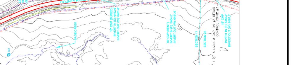
10 Lower Water Quality Pond Western Channel Upper Water Quality Pond Area of moderate rill erosion Gully erosion to Contact Water Pond Notes in red text boxes added by HDR Engineering for CCR Annual Inspection Report, January 2017
2018 Annual Landfill Inspection Report
 2018 Annual Landfill Inspection Report Landfill H.W. Pirkey Plant Southwestern Electric Power Company Hallsville, Texas December 17, 2018 Prepared for: Southwestern Electric Power Company H.W. Pirkey Plant
Table of Contents. Attachments Attachment A Photos Attachment B Site Map. Pages 3 of 9
 Table of Contents 1.0 Introduction...4 2.0 Description of Landfill...4 3.0 Review of Available Information...5 4.0 Inspection...5 4.1 Changes in Geometry since Last Inspection...5 4.2 Volume...5 4.3 Definitions
2018 Annual Landfill Inspection Report
 2018 Annual Landfill Inspection Report FGD Stackout Area H.W. Pirkey Plant Southwestern Electric Power Company Hallsville, Texas December 7, 2018 Prepared for: Southwestern Electric Power Company H.W.
NOTICE OF INTENT. Submitted To: Bremo Power Station 1038 Bremo Bluff Road Bremo Bluff, VA 23022
 NOTICE OF INTENT TO CLOSE INACTIVE CCR SURFACE IMPOUNDMENTS NOTICE OF INTENT Bremo Power Station Submitted To: Bremo Power Station 1038 Bremo Bluff Road Bremo Bluff, VA 23022 Submitted By: Golder Associates
Selecting the Right Closure Cap Option for Your Surface Impoundment or CCR Landfill
 2017 World of Coal Ash (WOCA) Conference in Lexington, KY - May 9-11, 2017 http://www.flyash.info/ Selecting the Right Closure Cap Option for Your Surface Impoundment or CCR Landfill Steven C. Lamb 1,
Chesapeake Energy Center. Submitted To: Chesapeake Energy Center 2701 Vepco Street Chesapeake, VA 23323
 NOTICE OF INTENT TO CLOSE INACTIVE CCR SURFACE IMPOUNDMENT NOTICE OF INTENT Chesapeake Energy Center Submitted To: Chesapeake Energy Center 2701 Vepco Street Chesapeake, VA 23323 Submitted By: Golder Associates
CLOSURE PLAN. CCR (b) GERS Little Broad Run Landfill. Mountaineer Plant New Haven, West Virginia. October, 2016
 GERS Little Broad Run Landfill. Mountaineer Plant New Haven, West Virginia. October, 2016") CLOSURE PLAN CCR 257.102(b) Little Broad Run Landfill Mountaineer Plant New Haven, West Virginia October, 2016 Prepared for : Appalachian Power Company - Mountaineer Plant New Haven, West Virginia Prepared
CLOSURE PLAN CCR 257.102(b) Little Broad Run Landfill Mountaineer Plant New Haven, West Virginia October, 2016 Prepared for : Appalachian Power Company - Mountaineer Plant New Haven, West Virginia Prepared
CLOSURE PLAN. CCR (b) GERS Landfill Area. Pirkey Power Plant Hallsville, Texas. October, 2016
 GERS Landfill Area. Pirkey Power Plant Hallsville, Texas. October, 2016") CLOSURE PLAN CCR 257.102(b) Landfill Area Pirkey Power Plant Hallsville, Texas October, 2016 Prepared for : Southwest Electric Power Company - Pirkey Plant Hallsville, Texas Prepared by: American Electric
CLOSURE PLAN CCR 257.102(b) Landfill Area Pirkey Power Plant Hallsville, Texas October, 2016 Prepared for : Southwest Electric Power Company - Pirkey Plant Hallsville, Texas Prepared by: American Electric
4.6. Low Impact and Retentive Grading
 4.6. Low Impact and Retentive Grading Low Impact Grading techniques focus on utilizing existing topography during Site layout to minimize cost. Proposing structures, roads, and other impervious surfaces
CLOSURE PLAN. CFR (b) Fly Ash Reservoir II. Cardinal Plant Brilliant, Ohio. August, 2016
 Fly Ash Reservoir II. Cardinal Plant Brilliant, Ohio. August, 2016") CLOSURE PLAN CFR 257.102(b) Fly Ash Reservoir II Cardinal Plant Brilliant, Ohio August, 2016 Prepared for: Cardinal Operating Company Cardinal Plant Brilliant, Ohio Prepared by: Geotechnical Engineering
CLOSURE PLAN CFR 257.102(b) Fly Ash Reservoir II Cardinal Plant Brilliant, Ohio August, 2016 Prepared for: Cardinal Operating Company Cardinal Plant Brilliant, Ohio Prepared by: Geotechnical Engineering
SUPPORTING DOCUMENT STORMWATER POLLUTION PREVENTION PLAN (SWPPP) NARRATIVE
 NARRATIVE") SUPPORTING DOCUMENT STORMWATER POLLUTION PREVENTION PLAN (SWPPP) NARRATIVE Please complete this narrative form and submit with your SWPPP drawings. Refer to Kitsap County Stormwater Design Manual Vol.
SUPPORTING DOCUMENT STORMWATER POLLUTION PREVENTION PLAN (SWPPP) NARRATIVE Please complete this narrative form and submit with your SWPPP drawings. Refer to Kitsap County Stormwater Design Manual Vol.
Shelbyville, KY Stormwater Best Management Practices. Section 2 EROSION PREVENTION AND SEDIMENT CONTROL PLAN
 Section 2 EROSION PREVENTION AND SEDIMENT CONTROL PLAN 2.1 Requirements The City of Shelbyville, KY will require an Erosion Prevention and Sediment Control (EPSC) Plan for most types of development construction.
City of Stoughton Erosion Control Permit Application (effective 2/6/2018)
") City of Stoughton Erosion Control Permit Application (effective 2/6/2018) Incomplete applications will not be accepted Project Name: Address of subject property: Landowner Name(s): Applicant Name: Landowner
City of Stoughton Erosion Control Permit Application (effective 2/6/2018) Incomplete applications will not be accepted Project Name: Address of subject property: Landowner Name(s): Applicant Name: Landowner
ENVIRONMENTAL ENGINEERING LAND SURVEYING
 ENVIRONMENTAL ENGINEERING LAND SURVEYING Closure Plan Scrubber Solids Pond No. 3 Sherburne County Generating Plant Introduction This plan describes the closure requirements for Scrubber Solids Pond No.
ATTACHMENT 1 WILSON MINE LECROY AREA SEMIPERMANENT DEWATERING SYSTEM
 ATTACHMENT 1 WILSON MINE LECROY AREA SEMIPERMANENT DEWATERING SYSTEM Reclamation plans for the Wilson Mine Lecroy area were approved by the Arkansas Department of Environmental Quality with a passive barrier
We Don t Have No Stinkin Dirt! Coal Ash Pond Closures (Traditional and an Alternative Method)
") 2017 World of Coal Ash (WOCA) Conference in Lexington, KY - May 9-11, 2017 http://www.flyash.info/ We Don t Have No Stinkin Dirt! Coal Ash Pond Closures (Traditional and an Alternative Method) Rosanna
2017 World of Coal Ash (WOCA) Conference in Lexington, KY - May 9-11, 2017 http://www.flyash.info/ We Don t Have No Stinkin Dirt! Coal Ash Pond Closures (Traditional and an Alternative Method) Rosanna
Landfill Closure, Intermediate Cover & Post-Closure Care. Municipal League Meeting
 Landfill Closure, Intermediate Cover & Post-Closure Care Municipal League Meeting 9-7-17 Gated and Closed Landfill Gated means no longer accepting waste. Closed means gated and final cover has been installed
PCE PRELIMINARY DRAINAGE ANALYSIS REPORT FOR WESTWOOD MIXED USE NEIGHBORHOOD PROJECT 772 NORTH FOREST ROAD TOWN OF AMHERST, ERIE COUNTY, NEW YORK
 PCE PRELIMINARY DRAINAGE ANALYSIS REPORT FOR WESTWOOD MIXED USE NEIGHBORHOOD PROJECT 772 NORTH FOREST ROAD TOWN OF AMHERST, ERIE COUNTY, NEW YORK MAY 19, 2014 Prepared By: Timothy M. Lavocat, P.E., CFM
Grass Buffer T-1. Description. Site Selection. Designing for Maintenance
 Description Grass buffers are densely vegetated strips of grass designed to accept sheet flow from upgradient development. Properly designed grass buffers play a key role in LID, enabling infiltration
Why Control and Prevent Erosion?
 Mark Risse, Rills are often obvious on steep or unprotected banks. Development of soil crust reduces infiltration, causing more runoff and erosion. This rill could easily turn into a gully if erosion is
Chapter 4 - Preparation of Stormwater Site Plans
 Chapter 4 - Preparation of Stormwater Site Plans The Stormwater Site Plan is the comprehensive report containing all of the technical information and analysis necessary for the City to evaluate a proposed
Consulting Engineers and Scientists. Closure Plan. Submitted by: GEI Consultants, Inc Voyager Drive Green Bay, Wisconsin
 Consulting Engineers and Scientists Regulation Compliance Report Submitted to: We Energies 333 West Everett Street, A231 Milwaukee, Wisconsin 53203 Submitted by: GEI Consultants, Inc. 3159 Voyager Drive
PRELIMINARY DRAINAGE REPORT LATHAM 200 MMSCFD GAS PROCESSING PLANT
 PRELIMINARY DRAINAGE REPORT LATHAM 200 MMSCFD GAS PROCESSING PLANT LOTS B, RECORDED EXEMPTION 1211-2-1, RECX13-0096 LOCATED IN THE NORTH 1/2 OF SECTION 2, TOWNSHIP 3 NORTH, RANGE 66 WEST, 6 TH PRINCIPAL
City of Lafayette Study Session Staff Report Design Review Commission
 ++ City of Lafayette Study Session Staff Report Design Review Commission Meeting Date: January 08, 2018 Staff: Subject: Chris Juram, Planning Technician SS12-17 Miramar Homebuilders, R-20 Zoning: Request
Wisconsin Contractors Institute Continuing Education
 Wisconsin Contractors Institute Continuing Education Erosion & Sediment Control Course # 12775 2 hours Wisconsin Contractors Institute N27 W23953 Paul Road, Suite 203 Pewaukee, WI 53072 Website: www.wicontractorsinstitute.com
Low Gradient Velocity Control Short Term Steep Gradient [1] Channel Lining Medium-Long Term Outlet Control Soil Treatment Permanent
![Low Gradient Velocity Control Short Term Steep Gradient [1] Channel Lining Medium-Long Term Outlet Control Soil Treatment Permanent](/thumbs/77/74849271.jpg "Low Gradient Velocity Control Short Term Steep Gradient [1] Channel Lining Medium-Long Term Outlet Control Soil Treatment Permanent") Grass Linings DRAINAGE CONTROL TECHNIQUE Low Gradient Velocity Control Short Term Steep Gradient [1] Channel Lining Medium-Long Term Outlet Control Soil Treatment Permanent [1] May be used on short, steep
Grass Linings DRAINAGE CONTROL TECHNIQUE Low Gradient Velocity Control Short Term Steep Gradient [1] Channel Lining Medium-Long Term Outlet Control Soil Treatment Permanent [1] May be used on short, steep
Exposed Geomembrane Cover Systems for Coal Ash Facilities
 2017 World of Coal Ash (WOCA) Conference in Lexington, KY - May 9-11, 2017 http://www.flyash.info/ Exposed Geomembrane Cover Systems for Coal Ash Facilities Clay Reichert, P.E. GSE Environmental, LLC,
Urban Conservation Practice Physical Effects ESTABLISHMENT, GROWTH, AND HARVEST NUTRIENT MANAGEMENT
 NOT WELL 800 - Urban Stormwater Wetlands A constructed system of shallow pools that create growing conditions for wetland plants to lessen the impacts of stormwater quality and quantity in urban areas.
SOP 6: Erosion and Sedimentation Control SOP 6: EROSION AND SEDIMENTATION CONTROL
 Standard Operating Procedures Central Massachusetts Regional Stormwater Coalition SOP 6: Erosion and Sedimentation Control SOP 6: EROSION AND SEDIMENTATION CONTROL Erosion and sedimentation from land-disturbing
APPLICATIONS IN FILTRATION AND DRAINAGE & EROSION CONTROL
 Lecture 36 APPLICATIONS IN FILTRATION AND DRAINAGE & EROSION CONTROL Prof. G L Sivakumar Babu Department of Civil Engineering Indian Institute of Science Bangalore 560012 Geotextile filter requirements:
Using the Updated RI Soil Erosion and Sediment Control Handbook. The Introductory Workshop for RIDEM/CRMC Staff January 23, 2015
 Using the Updated RI Soil Erosion and Sediment Control Handbook The Introductory Workshop for RIDEM/CRMC Staff January 23, 2015 URI Cooperative Extension NEMO URI Cooperative Extension NEMO White Oak,
A. Install all temporary erosion control measures (in accordance with MNDOT General Conditions 2573) prior to site disturbance.
 prior to site disturbance.") The language provided in these specifications is meant to serve as a reminder and provide a generic example of the type of language that should be provided in final construction documents. This language
The language provided in these specifications is meant to serve as a reminder and provide a generic example of the type of language that should be provided in final construction documents. This language
Alternative Names: Erosion Control Matting, Erosion Control Netting, Rolled Erosion Control Products (RECP)
") 4.5-s EROSION CONTROL BLANKET SYSTEM Alternative Names: Erosion Control Matting, Erosion Control Netting, Rolled Erosion Control Products (RECP) DESCRIPTION Erosion control blanket systems are woven or
4.5-s EROSION CONTROL BLANKET SYSTEM Alternative Names: Erosion Control Matting, Erosion Control Netting, Rolled Erosion Control Products (RECP) DESCRIPTION Erosion control blanket systems are woven or
RAIN GARDEN ILLINOIS URBAN MANUAL PRACTICE STANDARD. (feet) CODE 897 DEFINITION
 CODE 897 DEFINITION") ILLINOIS URBAN MANUAL PRACTICE STANDARD RAIN GARDEN (feet) CODE 897 Source: Kendall County Soil and Water Conservation District DEFINITION Rain gardens are small, shallow, flat bottomed depressions constructed
ILLINOIS URBAN MANUAL PRACTICE STANDARD RAIN GARDEN (feet) CODE 897 Source: Kendall County Soil and Water Conservation District DEFINITION Rain gardens are small, shallow, flat bottomed depressions constructed
Key elements : Filter Strips must be designed within parameters required by the Fort Wayne s Development Standards/Criteria Manual.
 4.4. Filter Strips Filter Strips are densely vegetated lands that treat sheet flow storm water from adjacent pervious and impervious areas. They function by slowing runoff, trapping sediment and pollutants,
UNIFIED FACILITIES GUIDE SPECIFICATIONS
 USACE / NAVFAC / AFCEC / NASA UFGS-02 66 00 (February 2010) ----------------------------- Preparing Activity: USACE Superseding UFGS-02 66 00 (April 2006) UNIFIED FACILITIES GUIDE SPECIFICATIONS References
Bowling Green, Kentucky Stormwater Best Management Practices (BMPs) Erosion Prevention Practices (EPPs) Activity: Nets and Mats (N and M)
 Erosion Prevention Practices (EPPs) Activity: Nets and Mats (N and M)") Bowling Green, Kentucky Stormwater Best Management Practices (BMPs) Erosion Prevention Practices (EPPs) Activity: Nets and Mats (N and M) EPP-11 PLANNING CONSIDERATIONS: Design Life: 1 yr Acreage Needed:
Bowling Green, Kentucky Stormwater Best Management Practices (BMPs) Erosion Prevention Practices (EPPs) Activity: Nets and Mats (N and M) EPP-11 PLANNING CONSIDERATIONS: Design Life: 1 yr Acreage Needed:
MASTER DEVELOPMENT DRAINAGE PLAN FOR MONUMENT HEIGHTS
 MASTER DEVELOPMENT DRAINAGE PLAN FOR MONUMENT HEIGHTS DRAINAGE REPORT STATEMENT ENGINEER'S STATEMENT: The attached drainage plan and report were prepared under my direction and supervision and are correct
Stormwater Standards. Clackamas County Service District No. 1. Planting Guide for Buffers
 Stormwater Standards Clackamas County Service District No. 1 APPENDIX B Planting Guide for Buffers Table of Contents Appendix B - Planting Guide for Buffers... Page B.1 General... 1 B.1.1 Introduction...
2.1.4 Roof Downspout Rain Gardens
 2008 SWMM, 2010 Revision City of Tacoma 2.1.4 Roof Downspout Rain Gardens Purpose and Definition Bioretention areas are shallow stormwater retention facilities designed to mimic forested systems by controlling
Pollutant Removal Benefits
 Bioswales Bioswales Similar to biocells, but have a slight, but positive grade toward an outlet Designed to convey the WQv event at very low velocities Promote filtration through native vegetation, infiltration
PLAN SUBMITTER'S CHECKLIST
 Page 1 of 8 PLAN SUBMITTER'S CHECKLIST FOR EROSION AND SEDIMENT CONTROL PLANS Please fill in all blanks and reference the plan sheets/pages where the information may be found, where appropriate, or write
SECTION 900 TURF ESTABLISHMENT
 SECTION 900 901.0 DESCRIPTION This section covers the furnishing of all labor, materials, tools, equipment and performances of all work and services necessary or incidental to turf restoration as indicated
HIGH PERFORMANCE COAL COMBUSTION RESIDUAL (CCR) SOLUTIONS
 SOLUTIONS") HIGH PERFORMANCE COAL COMBUSTION RESIDUAL (CCR) SOLUTIONS COAL COMBUSTION RESIDUAL (CCR) COMPLEXITY Committed to reliably generating and transmitting energy in an environmentally responsible manner, electric
HIGH PERFORMANCE COAL COMBUSTION RESIDUAL (CCR) SOLUTIONS COAL COMBUSTION RESIDUAL (CCR) COMPLEXITY Committed to reliably generating and transmitting energy in an environmentally responsible manner, electric
Structural Storm Water Best Management Practices (BMPs)
") Structural Storm Water Best Management Practices (BMPs) Storm Water Permitting: The SWPPP Revealed By Deron Austin, PE January 11, 2006 3:30-5:00 PM Orlando, Florida Presentation Outline Preface About
Structural Storm Water Best Management Practices (BMPs) Storm Water Permitting: The SWPPP Revealed By Deron Austin, PE January 11, 2006 3:30-5:00 PM Orlando, Florida Presentation Outline Preface About
BRISBANE BAYLANDS INFRASTRUCTURE PLAN FEBRUARY 2011 APPENDIX O DRAFT
 BRISBANE BAYLANDS INFRASTRUCTURE PLAN FEBRUARY 2011 APPENDIX O DRAFT PRELIMINARY STORM DRAIN CALCULATIONS ASSOCIATED WITH BRISBANE BAYLANDS REDEVELOPMENT BRISBANE, CALIFORNIA Prepared by BKF Engineers
SECTION 1 CLEARING /GRADING PERMIT APPLICATION:
 PLEASE REFER TO THE CLEARING & GRADING PERMIT CHECKLIST BELOW FOR SUBMITTAL REQUIREMENTS. SECTION 1 CLEARING /GRADING PERMIT APPLICATION: PROJECT ADDRESS (Street, Suite #): Parcel(s) #: Total Site Area
ST. MARY S SOIL CONSERVATION DISTRICT (SMSCD) AND DPW&T CONCEPT EROSION AND SEDIMENT CONTROL AND STORMWATER MANAGEMENT GUIDELINES AND CHECKLIST
 AND DPW&T CONCEPT EROSION AND SEDIMENT CONTROL AND STORMWATER MANAGEMENT GUIDELINES AND CHECKLIST") St. Mary s Soil Conservation District 26737 Radio Station Way, Suite B Leonardtown, MD 20650 Phone: 301-475-8402 ext. 3 Fax: 301-475-8391 www.stmarysscd.com St. Mary s County Government Department of Public
St. Mary s Soil Conservation District 26737 Radio Station Way, Suite B Leonardtown, MD 20650 Phone: 301-475-8402 ext. 3 Fax: 301-475-8391 www.stmarysscd.com St. Mary s County Government Department of Public
Town of Vershire Road Erosion Inventory Report
 Town of Vershire Road Erosion Inventory Report Taylor Valley Road. Photo taken by TRORC staff. Prepared by: 128 King Farm Road Woodstock, VT 05091 Inventory and report funded by the Vermont Agency of Transportation
SECTION 6. Routine Maintenance Activity Details
 SECTION 6 Routine Maintenance Activity Details 80. DEBRIS REMOVAL When Deadfall, and other objects, such as shopping carts, tires, appliances, and mattresses have accumulated in the drain. Why To prevent
5/15/2013. Basin Area. Vegetation. Rainfall & Runoff. Soil Type. Topics. Factors Influencing Erosion. Factors Influencing Erosion
 Topics Erosion, TESC and Construction sequencing Procedures and timing Remedies for failing sites Curtis Hinman WSU Extension and Bio Systems Eng. Faculty Low Impact Development Specialist chinman@wsu.edu
Severn River Sub-Watershed: BMP 09-Retrofit
 Project ID: BMP_09 Total Treated Drainage Area: 4.57 acres Total Treated Impervious Area: 2.9 acres Total Water Quality Volume (WQv): ~10,300 cubic feet; 0.236 acre-foot Rainfall Depth Treated (Pe): 1
CITY OF TUMWATER 555 ISRAEL RD. SW, TUMWATER, WA (360) (360) (FAX)
 (360) (FAX)") CITY OF TUMWATER 555 ISRAEL RD. SW, TUMWATER, WA 98501 (360) 754-4180 (360) 754-4126 (FAX) Email: cdd@ci.tumwater.wa.us APPENDIX II-C SHORT FORM CONSTRUCTION STORMWATER POLLUTION PREVENTION PLAN (SWPPP)
CITY OF TUMWATER 555 ISRAEL RD. SW, TUMWATER, WA 98501 (360) 754-4180 (360) 754-4126 (FAX) Email: cdd@ci.tumwater.wa.us APPENDIX II-C SHORT FORM CONSTRUCTION STORMWATER POLLUTION PREVENTION PLAN (SWPPP)
A Guided Tour of the 2014 Update to the Rhode Island Soil Erosion and Sediment Control Handbook
 A Guided Tour of the 2014 Update to the Rhode Island Soil Erosion and Sediment Control Handbook 2015 Land and Water Conservation Summit Saturday, March 14, 2015 URI Memorial Union, Kingston, RI Introduction
North Branch of Cypress Creek Ecological Restoration: A Comprehensive Approach to Stream Restoration
 North Branch of Cypress Creek Ecological Restoration: A Comprehensive Approach to Stream Restoration Rocky Powell Clear Creeks Consulting, LLC Keith D. Tate, P.E. BayLand Consultants & Designers, Inc.
Vegetated Filter Strips and Buffers
 3.15 Sediment Control Description: Buffer strips (existing vegetation) and filter strips (planted vegetation) are sections of vegetated land adjacent to disturbed areas. They are designed with low slopes
Slope Stability in Harris County
 Slope Stability in Harris County Slope Stability in Harris County Slope Stability in Harris County Overview of slope stability. Conditions, causes, and types of slope failures. HCFCD geotechnical investigation
GEOWEB slope & shoreline protection OVERVIEW
 SOIL STABILIZATION GEOWEB slope & shoreline protection OVERVIEW THE GEOWEB SYSTEM The Presto GEOWEB slope and shoreline protection system is an effective and economical solution to challenging slope-surface
Cost Estimating for Landfill Design
 Cost Estimating for Landfill Design Presentation at ASTSWMO Portland, Oregon Meeting August 14, 2007 Robert Maxey, P.E. EPA Office of Solid Waste Corrective Action Programs Branch maxey.bob@epa.gov Landfill
Glencoe Elementary School Parking Lot Retrofit 825 SE 51 st Street
 Glencoe Elementary School Parking Lot Retrofit 825 SE 51 st Street Project Summary Project Type: Technologies: Institutional parking lot retrofit demonstration project Vegetated infiltration swale with
CHAPTER 4. SPECIAL CONDITION EROSION CONTROL MEASURES
 CHAPTER 4. SPECIAL CONDITION EROSION CONTROL MEASURES 4.1 INFILTRATION BASIN AND TRENCH Figure 4.1. Infiltration basin and trench (Source: Department of Civil, Construction, and Environmental Engineering,
PERMANENT SEEDING. Overview of Sedimentation and Erosion Control Practices. Practice no. 6.11
 Overview of Sedimentation and Erosion Control Practices Practice no. 6.11 PERMANENT SEEDING Permanent vegetation controls erosion by physically protecting a bare soil surface from raindrop impact, flowing
WAKE COUNTY STORMWATER MAINTENANCE CHECKLIST
 WAKE COUNTY STORMWATER MAINTENANCE CHECKLIST STORMWATER CONTOL STRUCTURE BIORETENTION MAINTENANCE AGREEMENT RESPONSIBLE PARTY: PHONE #: ADDRESS: a. Remove debris from bioretention area. b. Inspect for
Soil Erosion and Sediment Control
 PDHonline Course C188 (3 PDH) Soil Erosion and Sediment Control Instructor: John Poullain, PE 2012 PDH Online PDH Center 5272 Meadow Estates Drive Fairfax, VA 22030-6658 Phone & Fax: 703-988-0088 www.pdhonline.org
CHECKLIST FOR PHASE II DRAINAGE REPORT
 I. COVER SHEET CHECKLIST FOR PHASE II DRAINAGE REPORT A. Name of Project B. Address C. Owner D. Developer E. Engineer F. Submittal date and revision dates as applicable II. GENERAL LOCATION AND DESCRIPTION
River Mile 10.9 Removal Action Overview
 River Mile 10.9 Removal Action Overview November 13, 2014 CAG Meeting Modified from CPG s RM10.9 Removal Action Final Design Report dated Nov. 2013 1 River Mile 10.9 Removal Action Activities Dredging:
Berm and Swale Complex
 Berm and Swale Complex Berm and swale systems are utilized in the landscape to capture, direct and infiltrate rainwater into the soil where it is needed. This complex allows a homeowner to develop a natural
Appendices: Glossary. General Terms. Specific Terms. Low Impact Development Approaches Handbook
 67 67 General Terms Specific Terms 66 Low Impact Development Approaches Handbook The vocabulary of low impact development is evolving, and many terms are used interchangeably and to describe the same or
Wisconsin NRCS Direct Volume Method Bank Recession Rate Categorizations
 2 Executive Summary The City of Ramsey contracted the Anoka Conservation District to complete an inventory of riverbank condition along the entire 5.8 miles of City that border the Mississippi River. The
Grand River Ravines Georgetown Township
 Grand River Ravines Georgetown Township Project Description: The Grand River Ravines County Park property is composed of the 68-acre former Fillmore at the Bend Open Space purchased in 1999 and two more
Alternative Cover Systems
 Alternative Cover Systems RemTech 2017 October 13, 2017 Outline Capping solutions Why use alternate cover systems Exposed geomembrane cap systems Geosynthetic Turf cap systems What is it? How is it installed?
5.0 Storm Water Landscape Guidance Introduction
 5.0 Storm Water Landscape Guidance Introduction Landscaping is a critical element to improve both the function and appearance of storm water management practices. Integrated storm water landscapes can
4.0 EROSION AND SEDIMENT PROCESS. 4.1 Mechanics of Erosion
 4.0 EROSION AND SEDIMENT PROCESS 4.1 Mechanics of Erosion SECTION 4 - EROSION AND SEDIMENT PROCESS Erosion is the wearing away of material by naturally occurring agents through the detachment and transport
Post Construction BMPs
 Post Construction BMPs Why are Post Construction BMPs important? With increased development brings the increase of impervious cover Parking lots, rooftops, driveways Storm water runoff volume increases
WET PONDS INSPECTION & MAINTENANCE CHECKLIST
 WET PONDS INSPECTION & MAINTENANCE CHECKLIST INTRODUCTION Once construction is completed, periodic site inspections are essential in order to monitor the effectiveness and to anticipate the maintenance
Safety Factor Assessment Plant McDonough-Atkinson Ash Pond 3 (AP-3) and Ash Pond 4 (AP-4)
 and Ash Pond 4 (AP-4)") Safety Factor Assessment Plant McDonough-Atkinson Ash Pond 3 (AP-3) and Ash Pond 4 (AP-4) Prepared for: Georgia Power Company Prepared by: Golder Associates Inc. 3730 Chamblee Tucker Road Atlanta, Georgia,
Safety Factor Assessment Plant McDonough-Atkinson Ash Pond 3 (AP-3) and Ash Pond 4 (AP-4) Prepared for: Georgia Power Company Prepared by: Golder Associates Inc. 3730 Chamblee Tucker Road Atlanta, Georgia,
17.1 INTRODUCTION CONTEXT CONCLUSIONS
 CHAPTER 17. FLOODPLAIN 17.1 INTRODUCTION 17.1.1 CONTEXT A floodplain is part of an extensive drainage and filtration system and water cycle that serves to contain flood waters from storms. Floodplain areas
Department of Agriculture. Conservation Service. United States. Natural Resources REVISED 8/26/16
 GENERAL NOTES: SYMBOL LEGEND 1. All work shall comply with the constriction specifications, drawings, project-specific quality assurance plan and other contract requirements. 2. All notes on the drawings
COMMUNITY DEVELOPMENT DEPARTMENT POLICY DRAINAGE FOR RESIDENTIAL PROJECTS WITH ONE OR TWO UNITS REVISED JANUARY 4, 2018
 COMMUNITY DEVELOPMENT DEPARTMENT POLICY DRAINAGE FOR RESIDENTIAL PROJECTS WITH ONE OR TWO UNITS REVISED JANUARY 4, 2018 A. California Residential Code Requirement - Construction plans shall indicate how
Poisoned Park? How Exide s Lead Contamination Risks Frisco s Grand Park
 Frisco City Hall has big plans to transform Stewart Creek into a Grand Park with lots of water features for kids to play in. Poisoned Park? How Exide s Lead Contamination Risks Frisco s Grand Park But
December 13, 2005 Meeting Status of NPDES Post Fire BMPs
 December 13, 2005 Meeting Status of NPDES Post Fire BMPs Agenda Overview of Current Operations At SSFL Impacts of Fire At SSFL Rebuilding & Improvement of BMPs Future Activities Site Tour Close-out 1 Santa
Chapter Six: Tree Removal and Erosion Control
 Chapter Six: Tree Removal and Erosion Control Through the combination of canopy and roots, trees help protect and stabilize the land. Their removal requires proper planning and adherence to land-based
SWANA Northern Lights Chapter. EXTINGUISHING THE IQALUIT LANDFILL FIRE Winnipeg May 20, 2015
 SWANA Northern Lights Chapter EXTINGUISHING THE IQALUIT LANDFILL FIRE Winnipeg May 20, 2015 Prepared by: Dr. Tony Sperling, P.Eng. Landfill Fire Control Inc. Slide 1 of 26 Extinguishing the Iqaluit Landfill
Experiences with Placement of Alternative Final Covers Presented by
 Experiences with Placement of Alternative Final Covers Presented by Leonard Butler, P.E., DEE, CSP Waste Management of Colorado, Inc. For ET 04 March 9, 2004 ET Cover Program Goals in Colorado: Provide
Drainage Analysis-Newgate/Phelps & Hatchett Hill Road Areas Rev. 0 Erosion & Sediment Control Measures
 Drainage Analysis-Newgate/Phelps & Hatchett Hill Road Areas Rev. 0 Erosion & Sediment Control Measures 4.0 EROSION & SEDIMENT CONTROL MEASURES After performing the analysis summarized above, Burns & McDonnell
When planning stormwater management facilities, the following principles shall be applied where possible.
 2.0 Principles When planning stormwater management facilities, the following principles shall be applied where possible. 2.0.1 Drainage is a regional phenomenon that does not respect the boundaries between
TOWNSHIP OF LOGAN SOIL & FILL IMPORTATION AND PLACEMENT APPLICATION SUBMITTAL CHECKLIST
 TOWNSHIP OF LOGAN SOIL & FILL IMPORTATION AND PLACEMENT APPLICATION SUBMITTAL CHECKLIST Applications: 5 copies of application - Applicant will reproduce the copies at his/her costs. The Township Clerk
Gloucester County PLAN SUBMITTER'S CHECKLIST
 Page 1 of 9 Gloucester County PLAN SUBMITTER'S CHECKLIST FOR EROSION AND SEDIMENT CONTROL PLANS Please fill in all blanks and please reference the plan sheets/pages where the information may be found,
IOWA FFA STATE SOILS CDE SATURDAY, OCTOBER 13, 2007 AMES, IOWA
 IOWA FFA STATE SOILS CDE SATURDAY, OCTOBER 13, 2007 AMES, IOWA 1. Moderately sloping has what percent slope: a. 9-14% b. 2-5% c. 5-9% d. over 14% 2. Which of the following horizons is the loose underlying
WQ-07 INFILTRATION TRENCH
 Greenville County Technical Specification for: WQ-07 INFILTRATION TRENCH 1.0 Infiltration Trench 1.1 Description Infiltration Trenches are excavations filled with stone to create an underground reservoir
Kickapoo Woods Restoration Plan
 Report Prepared for Friends of the Chicago River Kickapoo Woods Restoration Plan Gully Recommendations 6/30/2014 INTRODUCTION WRD Environmental (WRD) was retained by Friends of the Chicago River to help
Installation of the ArmorMax/LandLok Plus System. Randy Thompson, P.E. Propex Geotextile Systems
 Installation of the ArmorMax/LandLok Plus System Randy Thompson, P.E. Propex Geotextile Systems Product Category Brand Propex Full Line of Infrastructure Solutions Filtration Separation Stabilization Reinforcement
Evaluating Low Impact Development Practices for Stormwater Management on an Industrial Site in Mississippi
 Evaluating Low Impact Development Practices for Stormwater Management on an Industrial Site in Mississippi Dennis S. Painter, Tennessee Valley Authority, Nashville, Tennessee Donald Becker, Tennessee Valley
6.1. INTRODUCTION 6.2. EXISTING CONDITIONS
 Chapter 6: Stormwater Management 6.1. INTRODUCTION This Chapter describes the current drainage patterns on the Project Site, the stormwater management system that is proposed as part of the Proposed Project,
CHAPTER 26 LANDSCAPING (Chapter added in its entirety 05-08)
") CHAPTER 26 LANDSCAPING (Chapter added in its entirety 05-08) 26.01 DESCRIPTION AND PURPOSE. Landscaping is an important element of the use, development and preservation of land, and a significant factor
CHAPTER 26 LANDSCAPING (Chapter added in its entirety 05-08) 26.01 DESCRIPTION AND PURPOSE. Landscaping is an important element of the use, development and preservation of land, and a significant factor
Slope Stability Evaluation and Determination of Location of Long Term Stable Top of Slope 233 to 245 Dunlop Street West, Barrie, Ontario
 geotechnics construction materials testing Ref No.: 17-048 Trinity Consultants Ontario Inc. 885 Don Mills Road, Suite 106 Toronto, ON. M3C 1V9 Attn: Brian J. Schuyler, C.E.T., Senior Consultant Subject:
Table 4.7.1: Swales Potential Application and Storm Water Regulation
 4.7. Swales A swale is a vegetated open channel, planted with a combination of grasses and other herbaceous plants, shrubs, or trees. A traditional swale reduces peak flow at the discharge point by increasing
HEALTH SCIENCES BUILDING REDEVELOPMENT PROJECT
 INTRODUCTION In recent years, the University of Cincinnati (University) has demonstrated a commitment to identifying and implementing sustainable goals and objectives throughout University s Uptown Campuses.
The following general requirements will be met for all planter box installations:
 Greenville County Technical Specification for: WQ-25 PLANTER BOX 1.0 Planter Box 1.1 Description Planter boxes are designed to capture and temporarily store stormwater runoff. Planter Boxes are intended
Piles, Trenching, Inverters, Cables, Material Deliveries
 Agricultural Inspection Report General Information Project Name Albany Date of Inspection 20161012 Start/End Time 7:50 am Inspector s Name(s) Inspector s Title(s) Describe present phase of construction