IDENTIFIED GROWTH AREA ANALYSIS
|
|
|
- Melvin Owen
- 6 years ago
- Views:
Transcription

1 NOVEMBER 2015 IDENTIFIED GROWTH AREA ANALYSIS Moreton Bay Sunshine Coast INTER-URBAN BREAK
2 URBIS STAFF RESPONSIBLE FOR THIS REPORT WERE: Director Associate Director Consultant Job Code Report Number John Brannock Kris Krpan Sophie Lam BA3875 FINAL V1 Urbis Pty Ltd ABN All Rights Reserved. No material may be reproduced without prior permission. You must read the important disclaimer appearing within the body of this report. URBIS Australia Asia Middle East urbis.com.au
3 TABLE OF CONTENTS Executive Summary Introduction Purpose IGA Background Halls Creek IGA Beerwah East IGA Planning Context Regional Planning Context SEQ Regional Plan SEQ Regional Plan Defining Criteria Local Planning Context Defining Criteria Summary Discussion Literature and Case Studies History Of Inter-Urban Breaks Literature Review for Inter-Urban Breaks Managing Urban Development Safeguarding Natural and Productive Areas from Encroachment Preserving Character Management Defining Criteria Policy Approaches to Inter-Urban Breaks Case 1 London s Green Belt Policy Mapping Approach Case 2 Adelaide s Green Space System Policy Mapping Approach Case 3 Melbourne Policy Mapping Approach Key Findings Defining Criteria Moreton Bay-Sunshine Coast Inter-Urban Break Assessment Assessment Summary Recommendations Disclaimer Bibliography Legislation Appendix A Preliminary Moreton Bay-Sunshine Coast Inter-Urban break
4 FIGURES: Figure 1 - Halls Creek Identified Growth Area... 3 Figure 2 - Halls Creek Preliminary Precinct Plan... 4 Figure 3 - Aerial Map of Beerwah East IGA (Source: Nearmap)... 5 Figure 4 IGAs and the SEQ Regional Plan... 6 Figure 5 - Strategic Framework Land Use Elements Map Extract (Source: Sunshine Coast Regional Council) Figure 6 - Strategic Framework Community Identity, Character and Social Inclusion Elements Map Extract (Source: Sunshine Coast Regional Council)... 10
5 Executive Summary This report provides evidenced-based boundary criteria for establishing the limits of the Moreton Bay- Sunshine Coast inter-urban break. A review of the SEQ Regional Plan indicates that there has always been a regional policy intent that the Moreton Bay-Sunshine Coast inter-urban break would be more clearly defined by future planning processes. It is important to focus on a more accurate determination of the inter-urban break boundary which this study seeks to provide. An analysis has been undertaken of the Halls Creek and Beerwah Identified Growth Areas (IGAs) against research across relevant policies, literature and case studies both internationally and nationally. Both IGAs are identified as such under the SEQ Regional Plan, however are located outside the Urban Footprint. A review of the available literature indicates a number of emerging criteria around the purpose and management of inter-urban breaks, including as a tool for managing development of fringe urban areas, protection of areas of natural and agricultural significant and protection of a city s identity. The literature also emphasises the importance of conveying the purpose of the inter-urban break, to ensure clarity and flexibility in its ongoing management. Important case studies were also explored in order to determine the purpose of the inter-urban break in each case, and any criteria which were used to inform mapping and revisions of the urban boundary. Eight key criteria have been identified being the protection of high quality agricultural activities, extractive industries and places of cultural heritage significance; limiting impacts on ecological communities and catchments; preserving important landscape features and key views and vistas; and providing trunk services and public transport initiatives. The defining criteria gained from the policy, literature and case study reviews were collated and used to assess the suitability of both the Halls Creek and Beerwah IGAs for exclusion from the Moreton Bay- Sunshine Coast inter-urban break. The work undertaken by this study has identified a preliminary inter-urban break boundary, included in Appendix A. The key elements which have defined this mapping include significant ecological corridors, state reserves, and an inter-urban break investigation area within the Moreton Bay Regional Council Local Government Area. It is demonstrated that both IGAs can meet many of the key boundary criteria identified. Halls Creek benefits from the extensive analysis that has been undertaken of site constrains and proposed investment of infrastructure in Caloundra South. Beerwah East requires more analysis to determine how the site would perform against some of the criteria identified particularly with respect to its impact on infrastructure investment and environmental impacts. On balance, the Halls Creek IGA clearly is able to meet the extensive list of criteria identified and should not be classified as an integral part of the inter-urban break. The proponents of both the Halls Creek and Beerwah East IGAs need to be afforded the opportunity to establish their inter-urban breaks through a future planning process which identifies potential urban areas within the IGAs, any constrained areas, and any part which may form part of the inter-urban break. 1
6 1 Introduction Urbis on behalf of Stockland Developments Pty Ltd has prepared this report to inform the review of the South East Queensland Regional Plan 2009 (SEQ Regional Plan). This report aims to provide preliminary defining criteria for the Moreton Bay Sunshine Coast inter-urban break as it relates to the key Identified Growth Areas of Caloundra South-Halls Creek and Beerwah-Caloundra South Corridor. 1.1 PURPOSE This report is intended to inform the review of SEQ Regional Plan and provides: A snapshot of the Halls Creek and Beerwah Identified Growth Areas (IGA); A background to the concept of inter-urban breaks and the SEQ Regional Plan and identification of key inter-urban break defining criteria; A literature review of best practice relevant to the concept of inter-urban breaks and identification of key inter-urban break defining criteria; A review of approaches internationally and in Australia with respect to inter-urban breaks and identification of key inter-urban break defining criteria; An analysis of the Halls Creek and Beerwah IGAs against the defining criteria with a view to establishing a preliminary map of the Moreton Bay Sunshine Coat inter-urban break (focused on the Sunshine Coast segment of this inter-urban break); and Recommendations with respect to next steps that can be adopted in the regional planning review process. 2
7 2 IGA Background 2.1 HALLS CREEK IGA The relevant landholding consists of 1,278ha of land on Bells Creek Road and Coochin Creek comprising Lot 1 and 2 on RP The site is a former pine plantation located immediately south of the Caloundra South Priority Development Area. The site will have access to the new interchange on the Bruce Highway at the Roys Road and Bells Creek Road intersections once construction is finalised, and is located adjacent to the new Caloundra South Centre, future rail and road infrastructure, as well as the existing centre at Caloundra. FIGURE 1 - HALLS CREEK IDENTIFIED GROWTH AREA The site has been used for forestry or grazing purposes for the past 40 years, with large parts of the site significantly degraded and of limited environmental value. Overall, approximately 85% of the site (approximately 1,100ha) has been previously cleared and used for pine plantation and rural uses. The bulk of the site is currently cleared for grazing purposes. 3
.")
8 A previous study was undertaken by Urbis to review and analyse the suitability of the site for urban development. Following consideration of the opportunities and constraints affecting the site, a preliminary high level precinct plan was developed (refer to Figure 2 below). The preliminary precinct plan divides the site into a 782ha investigation area to the east and a 498ha Wetland and Conservation precinct to the west. A buffer zone is likely to form the boundary between the precincts depending on the results of further land use investigations. As the core wetland precinct of 140ha has been significantly degraded over time, the precinct plan designates this as a rehabilitation area. FIGURE 2 - HALLS CREEK PRELIMINARY PRECINCT PLAN 2.2 BEERWAH EAST IGA The Beerwah-Caloundra South Corridor IGA (Beerwah East) is located west of the Bruce Highway and generally east of the communities of Beerwah and Landsborough. The Local Growth Management Strategy prepared by Caloundra City Council prior to amalgamation had flagged an additional 1,800 dwellings to be constructed in Beerwah in the period. The IGA has a land area of 5,200ha. The Beerwah East IGA currently comprises large tracts of vegetated areas, as well as cleared agricultural parcels (refer to Figure 3 below) and further investigations are needed to determine the ultimate likely development footprint. The South-East Queensland Regional Plan designated Beerwah East as a residential and employment IGA within the Sunshine Coast area, with the potential to accommodate long-term employment growth, and contribute to economic diversity and employment in the sub-region. 4

9 FIGURE 3 - AERIAL MAP OF BEERWAH EAST IGA (SOURCE: NEARMAP) The SEQ Regional Plan 2009 builds on the prior version and aims to preserve a series of strategic interurban breaks that define and frame the extent of sub-regional communities. Again it does not geographically or notionally map a proposed inter-urban break for the IGAs however Figure 4 has been created for the purpose of this report to help place the IGAs in their regional planning context. 5

10 FIGURE 4 IGAS AND THE SEQ REGIONAL PLAN 6
11 3 Planning Context The planning context provides a key statutory basis for the identification of criteria that help define and understand the Moreton Bay-Sunshine Cost inter urban break. The following section of this report reviews relevant regional and local planning policy to help identify these criteria. 3.1 REGIONAL PLANNING CONTEXT SEQ REGIONAL PLAN 2005 In South East Queensland, the concept of inter-urban breaks came to prominence with the creation of the SEQ Regional Plan With respect to the Moreton Bay-Sunshine Coast inter-urban break the document then stated: Sunshine Coast The Sunshine Coast comprises the local government areas of Noosa, Maroochy and Caloundra. It has a current population of around 275,500 people and is expected to reach 424,000 people by The area provides a wide range of both urban and rural lifestyle options and is an important local, national and international holiday destination. The Sunshine Coast is a high-growth area, requiring careful management to ensure it does not lose the special qualities that make it such an attractive place for residents and visitors. The Urban Footprint has been carefully chosen to protect the special character and qualities of the small hinterland townships and the coastal communities north of the Maroochy River, while also providing significant greenfield development opportunities in the southern coastal parts of the Sunshine Coast. In order to preserve the identities of both the Sunshine Coast and Greater Brisbane, the Regional Plan protects the major inter-urban break between these two urban communities. It is particularly important that developable land is used efficiently on the Sunshine Coast to relieve pressures on land with important economic, rural, natural and scenic amenity values. The urban areas of the Sunshine Coast contain many attractive locations, which are close to beaches and rivers, providing opportunities for higher-density development. These infill opportunities must be identified and maximised, and greenfield land developed to achieve optimum yields and diversity. The economy of the Sunshine Coast is reliant on the tourism and construction sectors, with limited local employment opportunities. The Regional Plan aims to address this issue by providing additional land for business and industry development; improving infrastructure networks, particularly transport; and promoting new economic development opportunities such as the proposed knowledge hub, focused on the University the Sunshine Coast. (Section 8.1 SEQ Regional Plan 2005) The above extract helps provide some clarification that is lost in the current version of the SEQ Regional Plan with respect to what criteria were important for defining an inter-urban break, namely: Protection of places of special character and qualities; Preservation of the identities of Brisbane and the Sunshine Coast; and Promoting the efficient use of developable land while protecting rural, natural and scenic amenity values. 7
12 This information provides an important background and insight into the original intent and objectives of the inter-urban break for the Sunshine Coast. It is also important to recognise that the reason inter-urban breaks were not mapped in the SEQ Regional Plan 2005 was because of the intent for inter-urban breaks to be identified in LGMS, Structure Plan and planning scheme processes. (Source: Consultation Report on the Draft SEQ Regional Plan June 2005 Page 65). Consequently, SEQ Regional Plan 2005 (Section 8.9) sought to incorporate inter-urban breaks as part of future structure planning for major greenfield areas. The ensuing years saw processes of LGMS preparation, structure plans, master plans and Major Development Areas which created a complex and divergent environment for the delivery of major greenfield areas, culminating in the creation of the Urban Land Development Authority in 2007 in an attempt to streamline these processes. As a consequence of this dynamic planning environment, the original policy intent of the SEQ Regional Plan with respect to inter-urban breaks in some cases have not yet been fully considered and defined for these major greenfield areas. The Moreton Bay-Sunshine Coast interurban break is one such area that requires further assessment to define these boundaries SEQ REGIONAL PLAN 2009 The SEQ Regional Plan contains several policy elements relevant to inter-urban breaks which include: The sub-regional narrative which states: A major regional inter-urban break between the Sunshine Coast and Greater Brisbane preserves the distinctive character and identity of the Sunshine Coast and its many communities. The Urban Footprint ensures that anticipated urban development and growth will be managed to protect the Sunshine Coast s rural and landscape areas. (Queensland Government, 2009, p. 21). The plans principles and policies with respect to regional landscape areas and inter-urban breaks which state: Principle Focus coordinated planning, management and investment in priority regional landscape areas to optimise multiple community benefits. Policy Protect, maintain and enhance the function of inter-urban breaks. The supporting explanatory notes to which state: Inter-urban breaks Urban settlement is contained within the Urban Footprint with distinctive inter-urban breaks framing each sub-region and enhancing a sense of place for regional communities. The benefits provided by inter-urban breaks can be compromised by some land uses and activities. To provide clarity and certainty for land use planning, further investigation is warranted. This will ensure: the long-term viability of maintaining inter-urban breaks through effective management and by supporting appropriate rural industries, including rural production, tourism and recreation opportunities the clear identification of the important landscape planning and management functions of inter-urban breaks. The SEQ Regional Plan also goes on to define interurban break to mean: Non-urban land areas that separate or surround urban villages, towns and metropolitan areas (Queensland Government, 2009, p. 155). 8
13 It is noted that the 2009 version of the SEQ Regional plan reinforces the need for further investigation to define inter urban breaks. This policy intent seemingly anticipated that this process would occur as part of a further analysis/structure planning for Identified Growth Areas. To date, at a regional or sub-regional policy level, limited technical analysis has been undertaken to determine the inter-urban break. Analysis undertaken by the Local Government identifies the entirety of the Halls Creek Identified Growth Area as being part of the inter-urban break, citing the following value as being of particular importance. This inter-urban break plays an essential role in defining the character and identity of the Sunshine Coast and is an important component of the non-urban landscape which provides a setting for the iconic Glasshouse Mountains and Pumicestone Passage. (Source Appendix A Draft SEQ Plan Formal Submission April 2009 Sunshine Coast Regional Council) DEFINING CRITERIA The above analysis helps identify what criteria were important for defining an inter-urban break, namely: Maintaining places of special character and qualities; Preservation of the identities of the metropolitan areas of Brisbane and the Sunshine Coast; Promoting the efficient use of developable land while protecting rural, natural and scenic amenity values; Preserving the distinctive character and identity of the Sunshine Coast and its communities; Protection of rural and landscape value areas; The clear identification of the important landscape planning and management functions of inter-urban breaks. 3.2 LOCAL PLANNING CONTEXT The Sunshine Coast Planning Scheme 2014 (the Planning Scheme ) defines Halls Creek within the Strategic Framework. The Strategic Framework Land Use Elements map notes the site, as well as Beerwah/Caloundra South, as an Identified Growth Area under the SEQ Regional Plan. However the map also includes the Halls Creek site within a Regional Inter-urban Break, whereas Beerwah/Caloundra South is not included in this area. Furthermore, an annotation on the map relating to the Identified Growth Areas states: The Caloundra South (Halls Creek) identified Growth Area as recognised in the SEQ Regional Plan is not a Further Investigation Area for the purposes of the planning scheme but is subject to further planning assessment as part of the SEQ Regional Plan review. The Inter-urban Break mapping over Halls Creek is further defined in the Strategic Framework: Community Identity, Character and Social Inclusion Elements Map, which shows a Regional Inter-urban Break over the entire site, and a Sub-regional Inter-urban Break over the northern part of the site. Extracts from the Strategic Framework mapping are included in Figures 5 & 6 below. 9
 The themes that make up the Strategic Framework within the Planning Scheme do not explicitly define the values or criteria which informed the mapping")

14 FIGURE 5 - STRATEGIC FRAMEWORK LAND USE ELEMENTS MAP EXTRACT (SOURCE: SUNSHINE COAST REGIONAL COUNCIL) FIGURE 6 - STRATEGIC FRAMEWORK COMMUNITY IDENTITY, CHARACTER AND SOCIAL INCLUSION ELEMENTS MAP EXTRACT (SOURCE: SUNSHINE COAST REGIONAL COUNCIL) The themes that make up the Strategic Framework within the Planning Scheme do not explicitly define the values or criteria which informed the mapping of the Inter-urban Break. However the concept of the Inter-urban Break, as well as reference to Halls Creek more specifically, is cited throughout the themes of the Strategic Framework as follows: Settlement Pattern Strategic Outcome (l) states that the Caloundra South (Halls Creek) SEQ Regional Plan Identified Growth Area is subject to further planning assessment to determine whether this site is suitable for future development. Community identity, character and social inclusion Strategic Outcome (b) states, the Sunshine Coast remains distinct from and separate to other parts of the South East Queensland region with large areas of natural and rural landscape providing enduring regional and sub-regional inter-urban breaks between urban and rural residential areas. 10
15 Specific Outcome (a) of the implementation framework (Element 1 Landscape elements and features) identifies regional and sub-regional inter-urban breaks as a landscape element, which is also comprised of high value scenic areas, regional gateways and scenic routes. Specific Outcome (b) states regional and sub-regional inter-urban breaks are not reduced, fragmented or otherwise adversely impacted by urban or rural residential development. The location of the inter-urban breaks is further defined in this section as follows: Regional Inter-urban Break separates the Sunshine Coast from the Brisbane and Caboolture metropolitan area; and Sub-regional Inter-urban Break separates individual places within the Sunshine Coast DEFINING CRITERIA The above analysis helps identify what criteria where important for defining an inter-urban break, namely: The protection of high value scenic areas, regional gateways and scenic routes; and The Sunshine Coast remains distinct from and separate to other parts of the South East Queensland region with large areas of natural and rural landscape. 3.3 SUMMARY DISCUSSION Evident from the review of the SEQ Regional Plan background to inter-urban breaks, is that there has always been a policy intent that the Moreton Bay-Sunshine Coast inter-urban break would be more clearly defined by future planning processes, including as part of the process for establishing the suitability of Identified Growth Areas. The Sunshine Coast Regional Council has undertaken its own analysis through which it has determined that the entirety of the Halls Creek IGA is included in the inter-urban break, and the entirety of the Beerwah IGA excluded from the inter-urban break. This policy intent is also reflected in the Sunshine Coast Planning Scheme 2014, however this conflicts with the SEQ Regional Plan which identifies Halls Creek as an Identified Growth Area. It is also noted that the SEQ Regional Plan prevails over the local planning instrument where there is any conflict (Section 36 Sustainable Planning Act It is therefore important to focus on a more accurate determination of the inter-urban break boundary, which this paper seeks to provide. 11
16 4 Literature and Case Studies To further inform the defining criteria that can be used to help articulate the Moreton Bay-Sunshine Coast inter-urban break, this section provides a review of relevant literature and analysis of approaches taken internationally and nationally on the subject. 4.1 HISTORY OF INTER-URBAN BREAKS The concept of a green belt is well known in planning theory and one of the most notable planning approaches, with green belts being applied to cities across the world. There are a number of early plans for the introduction of inter urban or green break concepts surrounding cities from both the United Kingdom and United States of America. For the US, one of the most notable examples it the Emerald Necklace, comprised of over 400 hectares of public parkland surrounding the city of Boston. Similar principles were also reflected in Daniel Burnham s 1909 Plan of Chicago, which featured large public park systems extending from the city to the region (Daniels, 2010). Early attempts to apply this principle were also applied in the UK, however the concept is most directly attributed to the work of Ebenezer Howard and his 1902 novel Garden Cities of Tomorrow. Howard recognised that as people were increasingly residing in cities (for higher wages, greater social opportunities etc.), with careful planning they did not have to give up the nature and amenity benefits of living in the country (Howard, 1902). This concept was encapsulated by his Three Magnets of Town, Country and the ideal of Town-Country. Howard argued for a concentric city model characterised by smaller cities (max. populations around 30,000) with a large central park, moving through commercial and residential areas to an outermost manufacturing ring. The city is clearly defined from other settlements by agricultural and pastoral land (or the country) (Howard, 1902, Freestone, 2002). This plan was also characterised by the likes of large, grand tree lined boulevards to introduce nature into the heart of the city. The ideas presented by Howard were built upon by Raymond Unwin in the 1920s, who proposed green girdles around the city of London to constrain urban sprawl as the city experienced rapid growth (Ali, 2008). This idea was soon reflected in Patrick Abercrombie s greater London Plan 1944, with London s green belt a prominent example of the application of green belt principles. It was not until the later and more detailed Town and Country Planning Act of 1947 that, the use of formal part of the statutory land use planning system (Prior & Raemaekers, 2007). During this time, the UK school of planning was highly influential, and the idea spread further afield to Europe and America (Thomas & Littlewood, 2010). Present day, the application of inter urban breaks or similar green belt strategies have been applied to cities across the globe. In cities such as Berlin and Vienna, green belts occurred spontaneously with little intervention. In a number of Asian mega-cities, green belt strategies have been applied to varying degrees of success to address rapid population growth and rural-urban migration and the associated environmental issues (Yokohari, Takeuchi, Watanabe, & Yokota, 2000). The green belt around the Australian city of Sydney has been maintained, but the boundaries have been subject to review several times (Thomas & Littlewood, 2010). With the few, rare exceptions of spontaneously occurring green belts, they have almost universally been applied through top-down, regional planning and policies. 4.2 LITERATURE REVIEW FOR INTER-URBAN BREAKS The following assessment identifies the core criteria for the implementation of inter-urban breaks which emerge from a completed literature review. The criteria are organised under the theme of the common purpose which drives the use of inter-urban break policy. By identifying these criteria from the relevant literature, they form a series of planning first principles criteria which can be used to assess the interurban break approach for the Moreton Bay-Sunshine Coast inter urban break. 12
17 4.2.1 MANAGING URBAN DEVELOPMENT When introduced in the mid 1900 s, green belts were predominantly utilised to manage the growth of cities which were rapidly growing as a result of industrialisation. Although the purpose of green belts can vary significantly, almost universally their primary purpose appears to be as a spatial planning tool (Buxton & Goodman, 2003). Although green belts have largely been a successful tool for managing urban development, particularly within the UK, there is a significant portion of literature that investigates the further implications of this success, most notably the impact on housing prices due to shortages of urban land (Ali, 2008, Thomas & Littlewood, 2010). In many cases, green belts have failed by underestimating the true extent of development pressures to come (Evans & Freestone, 2010). Thomas and Littlewood (2010) assert that the green belts inherited from previous areas now seem outdated, and in some cases the boundaries they have imposed entirely arbitrary. In reality, they may be more of a measure to not prohibit greenfield development within city limits, but to ensure that it occurs in a planned manner (Evans & Freestone, 2010). Emerging Criteria Provide a tool for managing the development of fringe urban areas SAFEGUARDING NATURAL AND PRODUCTIVE AREAS FROM ENCROACHMENT Closely related to the intent to manage the growth of cities across landscapes, is the goal of preserving natural or productive (agricultural) areas of land from encroachment. There is limited research available about the actual ecological or productive benefits of maintaining an inter urban break available (Taylor & Amati, 2010). Amati (2007) and Taylor and Amati (2010) have provided criticism for this purpose when reviewing the London Green Belt, arguably one of the most well-known applications of inter urban break principles. They argue that the protection of land within the city regardless of its condition or value to society has lesser impact on improving ecological or amenity outcomes than identifying more valuable inner city land to protect. Papworth (2015) further identified that the maintenance and ideal of an inter urban break to preserve natural areas, can be done so at the expense of more environmentally valuable land that is located within the city itself. Emerging Criteria Protection of areas of natural or agricultural significance both within and adjoining an inter-urban break PRESERVING CHARACTER An important principle of inter urban break provision is to provide breathing space between spreading metropolises. This ensures that each city is clearly defined and connected to its own surrounding environment (Buxton & Goodman, 2003, Kühn, 2003). It is worthy of note that the idea of providing breaks between cities always focused on a narrow strip of land and ensuring the retention of large tracts of land that limits urban development. The green belt surrounding the Scottish city of Edinburgh, implemented since the late 1940 s, serves its intended purpose with an average width of approximately 3km (Prior & Raemaekers, 2007, Papworth, 2015). There is no evidence that a larger break between cities will have any impact on preserving city character or identity, this appears to be a modern interpretation based on our perception of cities when viewed from a car on a highway. 13
18 What appears to be of more importance than green belt width per se is the perception of the green belt as a self-contained landscape deserving protection (Taylor & Amati, 2010). This must be coupled with a means of viewing the green belt in order to appreciate its visual function and delineate the separation between metropolises (Taylor, Paine, & FitzGibbon, 1995). An example of the implications of not planning a green belt with this visual identity in mind is the Ottawa Greenbelt in Canada. The Greenbelt has not received widespread public support, due in part to its poor visibility, lack of a consistent identity, and lack of connecting element such as continuous scenic drive or trail system through the length of the Greenbelt (Taylor, Paine, & FitzGibbon, 1995). Emerging Criteria Inter-urban breaks assist in protecting a cities identity MANAGEMENT One of the contentious issues surrounding inter urban breaks is the concept of their ongoing management and preservation. There are two competing schools of thought on the management of green infrastructure, those that believe that the fundamental principle of successful green breaks is permanency (Buxton & Goodman, 2003) and those that believe green breaks should have more fluid forms which respond to environmental, social and economic conditions (Evans & Freestone, 2010). Buxton & Goodman (2003) maintain that where flexible policy is implemented, it will inevitably lead to land speculation in non-urban areas, resulting in pressure on decision makers to make decisions favouring development and eroding the purpose and public confidence in ongoing maintenance. Furthermore, difficulties also occur in the management of green belts between the regional and local level, as they are beneficial where applied as a broad spatial planning tool, but there protection and management may ultimately fall to a number of different local Council s which can decide applications within the inter urban break area at their discretion. This is where the value of having a clear purpose for the management of inter urban breaks becomes apparent, as discussed by Evans & Freestone (2010) with regards to the case of Sydney. Emerging Criteria The purpose of the Inter Urban Break must be clearly conveyed to ensure clarity and flexibility in its ongoing management DEFINING CRITERIA The above analysis helps identify what criteria where important for defining an inter-urban break, namely: Provide a tool for managing the development of fringe urban areas. Protection of areas of natural or agricultural significance both within and adjoining an inter-urban break. Inter-urban breaks assist in protecting a cities identity. The purpose of the Inter Urban Break must be clearly conveyed to ensure clarity and flexibility in its ongoing management. 4.3 POLICY APPROACHES TO INTER-URBAN BREAKS The following assessment identifies the core criteria for the implementation of inter-urban breaks which emerge from examination of comparable policy frameworks in London, Melbourne and Sydney. 14
.")
19 4.4 CASE 1 LONDON S GREEN BELT POLICY The London (Metropolitan) Green Belt is the largest of England s 14 Green Belts, covering 30% of the total area of all Green Belt land in England (CPRE, 2015). 92% of the Green Belt is undeveloped land, however there is a high prevalence of semi-urban uses relying on open land, including catteries, golf courses and pony paddocks (CPRE, 2015). The purpose of the Green Belt aligns closely with the historical role of Green Belts prevalent in the reviewed literature, including to control sprawl of developed areas, prevent neighbouring towns merging into one another, assist in safeguarding the countryside from encroachment, and assist in urban regeneration through encouragement of in-fill development on existing urban land (UK Government, 2015). FIGURE 7- LONDON GREEN BELT (SOURCE: THE TELEGRAPH) The management of the Green Belt, including principles for the level and type of development envisioned in this area, is set out in the National Planning Policy Framework (NPPF), which was released by the UK Government in March While the designation of Green Belt land, and the consideration of any development within these areas, is carried out at the Planning Authority level, the NPPF encourages consideration of their policies and principles at this decision-making stage (UK Government, 2015). The NPPF place stringent restrictions around development in the Green Belt, stating that a local planning authority should regard the construction of new buildings as inappropriate in the Green Belt, with the exception of agriculture and forestry uses, facilities for outdoor sport, outdoor recreation and cemeteries, space intensive uses including airfields, and limited infilling in villages (DCLG, 2012). Development generally is to preserve the openness of the Green Belt and is not to conflict with the purposes of including land within it (DCLG, 2012) MAPPING APPROACH The NPPF outlines a number of criteria which were considered in the mapping of the extent, as well as the boundaries, of the green belt. The considerations undertaken in the mapping of the extent of the Green Belt are considered to be able to be extrapolated from the five purposes of the Green Belt within the NPPF. These purposes are as follows: to check the unrestricted sprawl of large built-up areas; to prevent neighbouring towns merging into one another; 15
20 to assist in safeguarding the countryside from encroachment; to preserve the setting and special character of historic towns; and to assist in urban regeneration, by encouraging the recycling of derelict and other urban land. The document also outlines a number of guidelines that local planning authorities should follow when defining Green Belt boundaries. The NPPF states that when defining boundaries, local planning authorities should: ensure consistency with the Local Plan strategy for meeting identified requirements for sustainable development; not include land which is unnecessary to keep permanently open; where necessary, identify in their plans areas of safeguarded land between the urban area and the Green Belt, in order to meet longer-term development needs stretching well beyond the plan period; make clear the safeguarded land is not allocated for development at the present time. Planning permission for the permanent development of safeguarded land should only be granted following a Local Plan review which proposes the development; satisfy themselves that Green Belt boundaries will not need to be altered at the end of the development plan period; and define boundaries clearly, using physical features that are readily recognisable and likely to be permanent. When considering a revision of the Green Belt boundaries, the NPPF also advises that local planning authorities should ensure that substantial weight is given to any harm to the Green Belt (Department of Infrastructure, 2000). 4.5 CASE 2 ADELAIDE S GREEN SPACE SYSTEM POLICY Adelaide s Green Space system is articulated in the regional-level The 30-Year Plan for Greater Adelaide. The Plan outlines an open-space framework for Greater Adelaide based on linkages and maintenance of both metropolitan and urban fringe open space areas (DPLG, 2010). Significantly, the city s Metropolitan Open Space System (MOSS), which lies adjacent to the city s urban boundary, is the principal mechanism to control urban growth and provide a buffer to separate and define developed segments of the metropolitan area (DPTI, 2013). The MOSS includes the areas of the Adelaide City Park Lands, Hills Face Zone, the coastal foreshore, various urban buffers (including the Gawler Buffer which serves to separate the northern suburbs and the Town of Gawler, and major watercourses crossing the metropolitan area (refer to Figure 8) (DPTI, 2013). The concept of the MOSS and its practical implementation at the local planning level is facilitated thorough a combination of grants to local governments from the Planning and Development Fund, the direct purchase of land parcels by the State Government, an development of planning policies for land within the MOSS, aimed at retaining and improving open space character (DPTI, 2013). 16
")
21 FIGURE 8 - METROPOLITAN OPEN SPACE SYSTEM (SOURCE: DPTI) 17

22 4.5.2 MAPPING APPROACH The objectives of the MOSS closely align with the criteria upon which the mapping of the system is based upon. These objectives include: provision of a visual and scenic contrast to the built environment of Adelaide; provision of a buffer to separate and define developed or developable segments of the metropolitan area; assistance in the conservation of natural or semi-natural habitats and sites of scientific, cultural or heritage interest; accommodation of a range of passive and unstructured recreation and leisure areas; provision of the integration of stormwater management in association with recreation, aquifer recharge and water quality management; and provision of green corridors for movement of wildlife. Primarily, the MOSS has been established within areas of high environmental significance, as illustrated in Figures 9 & 10 below. FIGURE 9 - GREEN SPACE SYSTEM (SOURCE: DPLG) 18

23 FIGURE 10 - HIGH ENVIRONMENTAL SIGNIFICNCE AREAS (SOURCE: DPLG) The form of open space within the MOSS is encompassed by publicly owned open space that is directly available to the community for recreation, as well as privately owned open space that is not available for public recreation, but which is nevertheless intended to be appropriately zoned to preserve the open space and amenity characteristics of the land (DPTI, 2013). The processes and features contained within the MOSS, as well as the Greater Adelaide Open Space System more generally, are further defined in The 30-Year Plan for Greater Adelaide. The features to be contained within the MOSS include: urban forests and parks; watercourse and coastal linear parks; trails and recreation and sporting facilities; biodiversity assets and natural habitats; within the Gawler Buffer of the MOSS a visual buffer to act as a defining area between the town of Gawler, northern suburbs and new growth areas; and within the Hills Face Zone of the MOSS natural and rural landscape character areas, a landscape backdrop and areas of significant biodiversity (DPLG, 2010). 19
24 4.6 CASE 3 MELBOURNE POLICY Green wedges are the non-urban areas of metropolitan Melbourne that lie in a broad arc around the city, outside the Urban Growth Boundary (DSE, 2015). There are currently 12 designated Green Wedge areas spanning 17 municipalities in place. Green Wedges were set aside more than 30 years ago to conserve rural activities and significant natural features, particularly in the face of the continued growth of metropolitan Melbourne along major roads and rail links (DSE, 2015). The definition of Green Wedges is fairly conceptual, and has become even broader under the metropolitan strategy, Melbourne 2030: Planning for Sustainable Growth, in which the discussion around Green Wedges has been based around the wider issue of protecting non-urban areas around metropolitan Melbourne (DSE, 2015). The role of Green Wedges in restricting the outward expansion of development was further strengthened through the introduction of the Urban Growth Boundary (UGB) within the Melbourne 2030 strategy (DTPLI, 2014). Green Wedge Management Plans are systematically being developed by local councils for each Green Wedge, to identify a vision, objectives and actions for the use, development and maintenance of Green Wedges (DTPLI, 2014).. The Management Plans outline the zoning within each Green Wedge, precincts outlining key compatible land uses, any sites of biological significance, and guiding principles for development. 20

25 FIGURE 11 - MELBOURNE'S GREEN WEDGES (SOURCE: DSE) MAPPING APPROACH The shape and location of Melbourne s Green Wedges has been defined predominantly through the growth of the city along radial road and rail corridors (Department of Infrastructure, 2000). This growth has left large areas of undeveloped land in the shape of green wedges between these growth corridors (Department of Infrastructure, 2000). The edges of the Green Wedges have often been informed by arbitrary boundaries based on drainage catchments and the feasible extent of the water supply network, which have been implemented by metropolitan policies to define the UGB (Department of Infrastructure, 2000). The criteria informing the mapping of the extent of Green Wedges and the values in which they are intended to encompass can be defined as follows: conservation of significant landscape and habitat, floodways and catchments; protection of landscape and habitat where appropriate bushland and valuable stands of native vegetation; conservation and utilisation of proven stone and sand deposits for future extraction; 21

26 conservation of significant intensive agricultural areas and land having a high or potential value for the production of food; protect the landscape qualities as well as the recreational, botanical, heritage and environmental values of land surrounding urban areas; protect significant infrastructure through the inclusion of these Special Use Zones and Public Purposes Reserves in to the green wedges (e.g. Melbourne Airport land, and the eastern and western sewage treatment plants); maintenance of visual breaks between various locations; and conservation of open farmlands (Department of Infrastructure, 2000). Environmental conservation is a key theme in the establishment of Green Wedges, however the degree in which land within the Green Wedges contains high environmental values varies. Agencies such as the Department of Natural Resources and Environment, Melbourne Water or Parks Victoria have an interest in a small portion of Green Wedge land through land management or acquisition; however this is often limited to land in locations with high environmental values (Department of Infrastructure, 2000). The balance of the land often lacks direct investment from local governments to maintain any ecological processes or environmental values (Department of Infrastructure, 2000). The Urban Growth Boundary has been expanded a number of times since its designation, with the Urban Growth Boundary expanded to include 110km 2 of land previously designated within the green wedge in 2005, and a further expansion of 436km 2 in 2010 (Curtis, 2015). The expansion of land in the Urban Growth Boundary in 2010 occurred on the city s western, northern and south-eastern fringes, and is depicted in Figure 12 below. FIGURE 12 - URBAN GROWTH BOUNDARY 2010 EXPANSION (SOURCE: THE AGE) The studies and policies informing this expansion included a Strategic Assessment Agreement between the Victorian Government and the federal environment minister, which was signed on 4 March 2009, and a series of draft reports entitled Delivering Melbourne s Newest Sustainable Communities, released by the Victorian Government for public comment between 17 June and 17 July
27 The Strategic Assessment Agreement specifies a number of investigation areas which eventually informed the expansion of the UGB, and outlines a number of recommendations for criteria which should be considered in the assessment of these investigation areas for inclusion in the UGB. These criteria include: any threats of serious or irreversible environmental damage; the principle of inter-generational equality; the conservation of biological diversity and ecological integrity, which is identified as a fundamental consideration in decision-making; any indirect impacts on the environment resulting from the inclusion of the land in the Urban Growth Boundary, including impacts resulting from construction of major infrastructure, offsite impacts from stormwater management measures, or edge effects including weed introduction, pollution and feral animals; maintenance of important ecological processes; listed threatened and migratory species under the Act and their associated habitats; location and integrity of ecological communities, including their connectivity, extent and condition; any physical environmental processes influencing the environmental characteristics of the site or surrounds (e.g. fire and flooding); and places listed on the Commonwealth and National Heritage Lists (Environmental Protection and Biodiversity Conservation Act 1999 (Vic) Part 10 Strategic Assessments Section 146 (1) Agreement). The Agreement specifies that any impacts identified as likely to result from inclusion of the green wedges in the Urban Growth Boundary must be accompanied by sufficient evidence that the impacts can be mitigated or offset through appropriate management measures, implementation strategies and auditing/reporting processes (Environmental Protection and Biodiversity Conservation Act 1999 (Vic) Part 10 Strategic Assessments Section 146 (1) Agreement). The second set of policies instrumental in the expansion of the UGB was the Delivering Melbourne s Newest Sustainable Communities document. The document outlines the methodology undertaken to revise the UGB, which has been prepared to fulfil the requirements of the Strategic Assessment Agreement. The methodology is based around an opportunities and constraints assessment which encompassed a number of categories as follows: Agricultural activities some high value agricultural land in the south-east was proposed to be converted to urban uses given proximity of the land to major community services, potential to provide public transport services to the area, and sever limits to creating sustainable new communities in the Casey-Cardinia growth area (DTPLI, 2010). Biodiversity it is acknowledged that a number of ecological communities listed or nominated for listing under the Commonwealth Environment Protection and Biodiversity Conservation Act 1999 are potentially affected by the changes to the Urban Growth Boundary, with an assessment of the potential impacts outlined in a background technical report (DTPLI, 2010). Drainage corridors it is acknowledged that a number of catchments will be affected by the changes to the Urban Growth Boundary, with an assessment of potential impacts outlined in a background technical report (DTPLI, 2010). Extractive industry an approach to ensure extractive industry can continue to operate into the long term has been adopted. Where quarries are adjacent to the proposed Urban Growth Boundary, either the whole quarry area has been left outside the boundary, or where a buffer to the quarry area overlaps land within the Urban Growth Boundary, it has been shown as non-developable. Any 23
28 quarries located within the Urban Growth Boundary are subject to a 500m buffer of land not included I the calculation of the potential urban area (DTPLI, 2010). Heritage (including Aboriginal cultural heritage and post contact heritage) potential impacts on any places of heritage or cultural heritage importance are intended to be addressed through the preparation of Precinct Structure Plans, as well as part of the preparation and assessment of any development application within the Urban Growth Boundary (DTPLI, 2010). Landscape features landscape values are identified as a critical consideration in considering the future location of new urban areas, and assessment in this regard focused on enhancing key views and vistas (DTPLI, 2010). Land use a review was undertaken to identify existing land uses in the Investigation Areas that would inhibit or prevent urban development from occurring. The analysis focused on opportunities for reuse of land for urban development, as well as the potential to relocate existing uses (DTPLI, 2010). Salinity a salinity risk assessment was undertaken for each Investigation Area, and assessed the level of salinity risk, whether these risks could be mitigated, and the cost of undertaking these mitigation strategies (DTPLI, 2010). Soil capability although included as a category in the opportunities and constraints assessment, soil capability and areas of highly to moderately reactive soils was not considered to be a major constraint in determining the extent and location of future urban development (DTPLI, 2010). Transport consideration was given to the available opportunities to build on and complement public transport initiatives identified in The Victorian Transport Plan. The extent and scale of future infrastructure projects will be determined as part of preparing Growth Area Framework Plans (DTPLI, 2010). Trunk services (including water services, sewerage, electricity, gas and telecommunications) the assessment of land potentially suitable for development has taken account of the capacity to provide trunk services to new communities in the growth areas. The findings indicated that there were no insurmountable constraints for the provision of trunk services to the Investigation Areas (DTPLI, 2010). Wildfire care has been taken to avoid urban development in areas that have, or are likely to experience, significant fire risk. Fire protection requirements have been devolved to a part of the preparation of the Precinct Structure Plans (DTPLI, 2010). In addition to the above considerations, the actual cadastral mapping of the Urban Growth Boundary was aligned with property boundaries, roads and existing natural features such as rivers, contour lines, and edges of biodiversity and habitat sites. 4.7 KEY FINDINGS DEFINING CRITERIA The criteria informing the mapping of various forms of inter-urban breaks, both nationally and internationally, can be used to not only identify the role of inter-urban breaks, but to define a set of values which inform the location, boundaries and extent of inter-urban breaks. These can be summarised as eight key criteria, as follows: Protection of high value agricultural activities; Limiting impacts on ecological communities of importance; Managing impacts on local drainage corridors and catchments; 24
29 Protecting extractive resources and existing extractive activities; Conserving places of cultural heritage significance; Preserving important landscape features and key view and vistas; Limiting impacts on existing conflicting land uses; and Providing trunk services and public transport initiatives 25
30 5 Moreton Bay-Sunshine Coast Inter-Urban Break Assessment The following tabular assessment considers the Halls Creek and Beerwah IGAs against the inter-urban break criteria identified by this report. The purpose of this assessment is to inform the development of preliminary recommendations and mapping that help define the purpose and boundaries of the Moreton Bay- Sunshine Coast inter-urban break. For each of the defining criteria identified through this report, both IGAs have been considered and a level of compliance against those criteria assigned. Common criteria have been captured as one item to reduce repetition and emphasise those criteria that appear most significant. Levels of compliance ranges from general compliance, partial or non-compliance represented by the following symbols: Full compliance Partial compliance Non-compliance TABLE 1 - IGA CRITERIA ASSESSMENT DEFINING CRITERIA HALLS CREEK IGA COMPLIANCE BEERWAH IGA COMPLIANCE COMMENT 1. Maintaining places of special character and qualities Both IGAs would accommodate low-density development and would not likely obstruct views to the Glasshouse Mountains and Pumicestone Passage. With respect to city identify and character this is discussed in items 2-9 below. 2. Preservation of local identify between the metropolitan areas of Brisbane and the Sunshine Coast 3. Preserving the distinctive character and The preservation of identity partly relates to the concept of physical separation of the metropolitan areas of Brisbane and Sunshine Cost. For most, this separation is observed when traveling along the Bruce Highway between the two areas. Given the nature of this corridor (with significant forestry reserves) and with the ultimate rehabilitation of vegetation on the Caloundra South site facing the highway, it will be 26
31 DEFINING CRITERIA HALLS CREEK IGA COMPLIANCE BEERWAH IGA COMPLIANCE COMMENT identity of the Sunshine Coast and its communities 4. Protection of rural and landscape value areas 5. The protection of high value scenic areas, regional gateways and scenic routes likely that neither IGA will be visible from this arterial. Considering a helicopter view of the two areas, it is noted that a 16.5km (approx.) distance between the Moreton Bay and Sunshine Coast urban footprint areas remains even with the inclusion of the Halls Creek IGA in the urban footprint. Subject to further analysis it would be reasonable to assume that this extent of separation would likely be sufficient to visually and functionally separate the two metropolitan areas as desired by the adjoining criteria. 6. The protection of high value scenic areas, regional gateways and scenic routes 7. The Sunshine Coast remains distinct from and separate to other parts of the South East Queensland region with large areas of natural and rural landscape 8. Inter-urban breaks assist in protecting a cities identity 9. Preserving important landscape features and key view and vistas 10. Promoting the efficient use of developable land while protecting rural, natural and scenic amenity values Detailed analysis has been undertaken by Stockland to inform the development footprint of the Halls Creek land holding and these are summarised by various other technical reports. The findings of this analysis have helped determine a footprint that 27
32 DEFINING CRITERIA HALLS CREEK IGA COMPLIANCE BEERWAH IGA COMPLIANCE COMMENT 11. Protection of areas of natural or agricultural significance both within and adjoining an inter-urban break 12. Limiting impacts on ecological communities of importance protects rural, natural and scenic amenity values. In addition, development of Halls Creek IGA would take advantage of the significant investment in infrastructure being undertaken as part of Caloundra South, to the north and adjacent of the site including, roads, rail, community infrastructure, and service infrastructure such as sewer and water. With respect to the Beerwah IGA, we understand that a similar level of technical analysis has not yet been finalised however we would assume that an appropriate footprint will be identified. With respect to efficiency of land use, Beerwah will benefit from the future rail line and stations however, will not have the benefit of the extensive adjoining infrastructure that Caloundra South provides for Halls Creek. 13. The clear identification of the important landscape planning and management functions of inter-urban breaks Much of the literature and case studies reviewed by this report reinforced the importance of a clear articulation of the purpose of an inter-urban break to both assist in the definition of a physical boundary but also its ongoing management or change. 14. The purpose of the Inter Urban Break must be clearly conveyed to ensure clarity and flexibility in its ongoing management At present, the SEQ Regional Plan identifies a clear policy intent to establish a Moreton-Bay Sunshine Coast inter-urban break, however its purpose and consequently its boundaries have not been identified and agreed by all stakeholders. 15. Managing the development of fringe urban areas Establishing a clear purpose and boundaries for the inter-urban break will assist in establishing a urban management framework for the Moreton Bay-Sunshine Coast corridor. 16. Protection of high value agricultural activities The Halls Creek IGA does not contain, nor is in close proximity to, any areas of high value agricultural activities. The Beerwah IGA includes ongoing forestry licences would need to be negotiated prior to this rural activity ceasing operations. 28
33 DEFINING CRITERIA HALLS CREEK IGA COMPLIANCE BEERWAH IGA COMPLIANCE COMMENT 17. Managing impacts on local drainage corridors and catchments Identified local drainage corridors and waterways are located to the south of the site, and are sufficiently separated from the Halls Creek IGA to ensure any future development within the IGA would not have adverse impacts on these catchments. 18. Protecting extractive resources and existing extractive activities The sites do not contain, nor are in close proximity to, any existing extractive activities. 19. Limiting impacts on places of cultural heritage significance The sites contains limited cultural heritage significance, subject to further analysis and expert advice. 20. Limiting impacts on existing conflicting land uses The sites are both surrounded by varying land uses including, farming, turf farms, and tourism activities, however it would be expected that any amenity impacts could be managed through a structure planning process. 21. Capacity to provide trunk services and build on public transport initiatives Development within the Halls Creek IGA would take advantage of the significant investment in infrastructure undertaken as part of Caloundra South, to the north of the site. This infrastructure includes trunk services, as well as major road and public transport projects, including the proposed Sunshine Motorway extension connecting Caloundra Road to the Bruce Highway, and the proposed CAMCOS public transport corridor. The Beerwah IGA would require further analysis and investigation to determine its infrastructure implications. 29
34 5.1 ASSESSMENT SUMMARY The above assessment demonstrates that both IGA s can meet many of the key criteria identified. Halls Creek benefits from the extensive analysis that has been undertaken of site constrains and proposed investment of infrastructure in Caloundra South. Beerwah East requires more analysis to determine how the site would perform against some of the criteria identified particularly with respect to its impact on infrastructure investment and environmental impacts. On balance, the Halls Creek IGA clearly is able to meet the extensive list of criteria identified and should not be classified as part of the inter-urban break. 30
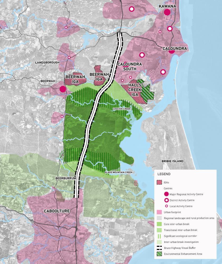
35 6 Recommendations This study aims to provide preliminary defining criteria for the Moreton Bay Sunshine Coast inter-urban break as it relates to the Identified Growth Areas of Halls Creek and Beerwah. Our conclusions and recommendations for the mapping of the inter-urban break are as follows: Additional work is needed to crystallise the purpose of the Moreton Bay-Sunshine Coast inter-urban break. It is evident that some of the uncertainty with respect to the boundaries of the inter-urban break stem from the lack of clarity around the overarching purpose of the break. From this preliminary assessment, the overarching purpose appears to relate to the protection of environmental values, city identity and hydraulic values in particular. Firming up the purpose through a collaborative approach with stakeholders will assist in informing the refinement of a defined interurban break boundary. The work undertaken by this study however, has identified a preliminary inter-urban break boundary, as depicted in Appendix A which builds upon the mapping established by Council in its planning scheme. The key elements which have defined this mapping are as follows: Core Inter-Urban Break represents areas within the two key east-west environmental corridors established by the Coochin Creek and Glass Mountain Creek Catchments. The hydrological and ecological values of these two corridors form two definitive barriers within this corridor that form a natural and logical boundary for the Core areas of the inter-urban break. The core is viewed by this study as the area of greatest significance with respect to preserving hydrological, ecological and urban form values. Limited land uses with the exception of tourism, agriculture and key resources would be expected in this area. Frame Inter-Urban Break represents a transition area adjoining the significant ecological corridors where a more diverse approach to the management of the inter-urban break may be appropriate. In this regard a higher diversity of land uses may be appropriate within the transition area including agriculture and community facilities, but not residential development. Significant ecological corridors have been identified and incorporated throughout the interurban break, following waterways and areas of remnant vegetation. These areas also form part of the Core inter-urban break. Bruce Highway Visual Buffer is proposed as a specific measure for the Moreton Bay-Sunshine Coast inter-urban break given the importance of maintaining visual separation from Brisbane as was identified by this study. This arterial takes on added significance given it is the primary travel experience for most commenters between Brisbane and the Sunshine Coast. The aim of the buffer is to ensure the non-urban nature of this corridor is maintained as viewed from the highway. State Reserves have also been situated within the mapped inter-urban break to contextualise the nature of predominant land uses occurring in the corridor. The extent of the inter-urban break is contained to the Sunshine Coast Regional Council Local Government Area. An inter-urban break investigation area has been identified within the Moreton Bay Regional Council Local Government Area, and is intended to depict those parts of the inter-urban break which will need to be defined with further investigations and studies in the context of the local planning and environmental controls within Moreton Bay. Both the Halls Creek and Beerwah East IGAs need to be afforded the opportunity to establish their inter-urban breaks through a future planning process which identifies potential urban areas within the IGAs, those parts of the IGAs constrained by environmental, agricultural or other factors, and finally those parts of the IGA which may form part of the inter-urban break. 31
36 This study provides a preliminary map of the Moreton Bay-Sunshine Coast inter urban break, which forms the basis for future analysis. It would be recommended that a consolidated and joint approach is adopted for determining the inter-urban break for both IGAs. 32
37 Disclaimer This report is dated March 2016 and incorporates information and events up to that date only and excludes any information arising, or event occurring, after that date which may affect the validity of Urbis Pty Ltd s (Urbis) opinion in this report. Urbis prepared this report on the instructions, and for the benefit only, of Stockland Development Pty Ltd (Instructing Party) for the purpose of Stockland (Purpose) and not for any other purpose or use. To the extent permitted by applicable law, Urbis expressly disclaims all liability, whether direct or indirect, to the Instructing Party which relies or purports to rely on this report for any purpose other than the Purpose, and to any other person which relies or purports to rely on this report for any purpose whatsoever (including the Purpose). In preparing this report, Urbis was required to make judgements which may be affected by unforeseen future events, the likelihood and effects of which are not capable of precise assessment. All surveys, forecasts, projections and recommendations contained in or associated with this report are made in good faith and on the basis of information supplied to Urbis at the date of this report, and upon which Urbis relied. Achievement of the projections and budgets set out in this report will depend, among other things, on the actions of others over which Urbis has no control. In preparing this report, Urbis may rely on or refer to documents in a language other than English, which Urbis may arrange to be translated. Urbis is not responsible for the accuracy or completeness of such translations and disclaims any liability for any statement or opinion made in this report being inaccurate or incomplete arising from such translations. Whilst Urbis has made all reasonable inquiries it believes necessary in preparing this report, it is not responsible for determining the completeness or accuracy of information provided to it. Urbis (including its officers and personnel) is not liable for any errors or omissions, including in information provided by the Instructing Party or another person or upon which Urbis relies, provided that such errors or omissions are not made by Urbis recklessly or in bad faith. This report has been prepared with due care and diligence by Urbis and the statements and opinions given by Urbis in this report are given in good faith and in the reasonable belief that they are correct and not misleading, subject to the limitations above. 33
38 7 Bibliography Ali, A. K. (2008). Greenbelts to Contain Urban Growth in Ontario, Canada: Promises and Prospects. Planning, Practice & Research, 23:4, Amati, M. (2007). From a Blanket to a Patchwork: The Practicalities of Reforming the London Green Belt. Journal of Environmental Planning and Management, 50:5, Barker, K. (2004). Review of Housing Supply, Final Report. London: HM Treasury. Buckley, K. (2004). Green Web Sydney: A strategic approach to biodiversity conservation in the Sydney Region. Retrieved October 29, 2015, from Buxton, M., & Goodman, R. (2003). Protecting Melbourne's greenbelt. Urban Policy and Research, 21:2, CPRE. (2015). The London (Metropolitan) Green Belt. Retrieved October 28, 2015, from Curtis, C. (2015). The History of Green Wedges - The Last 40 Years. Retrieved October 30, 2015, from Daniels, T. (2010). The Use of Green Belts to Control Sprawl in the United States. Planning, Practice & Research, 25:2, DCLG. (2012). National Planning Policy Framework. Retrieved November 4, 2015, from Department for Communities & Local Government. (2014, March 6). 9. Protecting Green Belt land. Retrieved September 23, 2015, from Planning Practice Guidance: Department of Infrastructure. (2000). Green Wedges and Non-urban Issues. Retrieved November 4, 2015, from data/.../technical_report_2_greenwedges.pdf DPLG. (2010). The 30-Year Plan for Greater Adelaide. Retrieved November 10, 2015, from DPTI. (2013). Metropolitan Open Space System (MOSS). Retrieved November 10, 2015, from data/assets/.../moss_factsheet_aug_2013.pdf DSE. (2015). Green Wedges. Retrieved October 29, 2015, from DTPLI. (2010). Delivering Melbourne's Newest Sustainable Communities. Retrieved November 4, 2015, from DTPLI. (2014). Green Wedges. Retrieved October 29, 2015, from Edwards, M. (2000). Sacred cow or sacrifical lamb? Will London's greenbelt have to go? City, 4:1,
39 Evans, C., & Freestone, R. (2010). From Green Belt to Green Web: Regional Open Space Planning in Sydney, Planning, Practice & Research, 25:2, Freestone, R. (2002). Greenbelts in city and regional planning. In K. C. Parsons, & D. Schuyler, Garden City to Green City: The Legacy of Ebenezer Howard (pp ). Baltimore: Johns Hopkins University Press. GWC. (2014). Green Wedges Coalition - A vision for Melbourne. Retrieved October 29, 2015, from Herington, J. (1990). Beyond Greenbelts: Managing. London: Jessica Kingsley Publishers. Howard, S. E. (1902). Garden Cities of To-morrow. London: Swan Sonnenschein & Company, Limited. Kühn, M. (2003). Greenbelt and Green Heart: seperating and integrating landscapes in European city regions. Landscape and Urban Planning, 64: Longley, P., Batty, M., Shepherd, J., & Sadler, G. (1992). Do Green Belts Change the Shape of Urban Areas? A Preliminary Analysis of the Settlement Geography of South East England. Regional Studies, 26: 5, Osborn, F. J. (1969). Greenbelt Cities. London: Evelyn, Adams & Mackay. Papworth, T. (2015). The green noose: An analysis of Green Belts and proposals for reform. London: Adam Smith Research Trust. Prior, A., & Raemaekers, J. (2007). Is green belt fit for purpose in a post-fordist landscape? Planning Practice & Research, 22:4, Queensland Government. (2009). South East Queensland Regional Plan Brisbane: Queensland Government. Rowe, J. E. (2012). Auckland's Urban Containment Dilemma: The Case for Green Belts. Urban Policy and Research, 30:1, Schilling, J., & Logan, J. (2008). Greening the Rust Belt: A Green Infrastructure Model for Right Sizing America's Shrinking Cities. Journal of the American Planning Association, 74:4, Scott, A. (2014, September 17). How to make the green belt productive - but still green. Retrieved September 23, 2015, from The Conversation: SROC. (1997). Green Web Sydney: A Vegetation Management Plan for the Sydney Region. Retrieved October 29, 2015, from SSROC. (2015). Green Web. Retrieved October 29, 2015, from Tang, B.-s., Wong, S.-w., & Lee, A. K.-w. (2007). Green belt in a compact city: A zone for conservation or transition?. Landscape and Urban Planning, 79, Taylor, J., Paine, C., & FitzGibbon, J. (1995). From greenbelt to greenways: four Canadian case studies. Landscape and Urban Planning, Taylor, M., & Amati, L. (2010). From Green Belts to Green Infrastructure. Planning Practice & Research, 24:2,
40 TCPA. (2003). TCPA Policy Statement - Green Belts. Retrieved October 28, 2015, from Thomas, K., & Littlewood, S. (2010). From Green Belts to Green Infrastructure? The Evolution of a New Concept in the Emerging Soft Governance of Spatial Strategies. Planning Practive & Research, 25:2, UK Government. (2015). National Planning Policy Framework. Retrieved October 2015, 2015, from United Nations. (2014, July 10). World s population increasingly urban with more than half living in urban areas. Retrieved September 30, 2015, from United Nations Website: Yokohari, M., Takeuchi, K., Watanabe, T., & Yokota, S. (2000). Beyond Greenbelts and Zoning: A New Planning Concept for the Environment of Asian Mega-Cities. Landscape and Urban Planning, 47 (3-4), LEGISLATION Environmental Protection and Biodiversity Conservation Act 1999 (Vic) Part 10 Strategic Assessments Section 146 (1) Agreement 36
41 Appendix A Preliminary Moreton Bay-Sunshine Coast Inter-Urban break APPENDICES
42 APPENDICES

43 Brisbane Level 7, 123 Albert Street Brisbane QLD 4000 t f Gold Coast 45 Nerang Street Southport QLD 4215 t Sydney Level 23, Darling Park Tower Sussex Street Sydney, NSW 2000 t f Melbourne Level 12, 120 Collins Street Melbourne VIC 3000 t f Perth Level 1, 55 St Georges Terrace Perth WA 6000 t f Australia Asia Middle East info@urbis.com.au
Oxford Green Belt Study. Summary of Final Report Prepared by LUC October 2015
 Oxford Green Belt Study Summary of Final Report Prepared by LUC October 2015 Project Title: Oxford Green Belt Study Client: Oxfordshire County Council Version Date Version Details Prepared by Checked by
INCREMENTAL CHANGE AREA REVIEW March 2015 Page 1
 INCREMENTAL CHANGE AREA REVIEW March 2015 Page 1 Table of Contents Introduction... 3 Background to Review... 3 Comparison of the Schedules to the General Residential Zone... 7 Methodology... 7 Policy Context...
Neighbourhood Planning Local Green Spaces
 Neighbourhood Planning Local Green Spaces Introduction... 2 1. Why green space is important... 4 2. Neighbourhood plans and green space... 6 3. Evidence... 8 Statutory designations... 9 Green space audit...
ROCHFORD LOCAL DEVELOPMENT FRAMEWORK: Sustainability Appraisal/ Strategic Environmental Assessment. Rochford Core Strategy Preferred Options Document
 ROCHFORD LOCAL DEVELOPMENT FRAMEWORK: Sustainability Appraisal/ Strategic Environmental Assessment Non Technical Summary Rochford Core Strategy Preferred Options Document October 2008 SUSTAINABILITY APPRAISAL
Tāhuhu whakaruruhau ā-taone The sheltering ridge pole
 B2. Tāhuhu whakaruruhau ā-taone - Urban growth and form B2.1. Issues Tāhuhu whakaruruhau ā-taone The sheltering ridge pole Auckland s growing population increases demand for housing, employment, business,
Western City District What we heard
 What we heard Vision to 2056 and Priorities Governance and implementation Infrastructure and funding The protection of the natural landscape including biodiversity and the Metropolitan Rural Area for food
Settlement Boundaries Methodology North Northumberland Coast Neighbourhood Plan (August 2016)
") Introduction This background paper sets out a methodology for the definition of settlement boundaries in the North Northumberland Coast Neighbourhood Plan. The neighbourhood plan is planning positively
Introduction This background paper sets out a methodology for the definition of settlement boundaries in the North Northumberland Coast Neighbourhood Plan. The neighbourhood plan is planning positively
Plan Modification to Chapter B2 of the Auckland Unitary Plan(AUP) Operative in part (15 November 2016)
 Operative in part (15 November 2016)") UNITARY PLAN UPDATE REQUEST MEMORANDUM TO FROM Phill Reid Linley Wilkinson DATE 25 September 2018 SUBJECT Plan Modification to Chapter B2 of the Auckland Unitary Plan(AUP) Operative in part (15 November
UNITARY PLAN UPDATE REQUEST MEMORANDUM TO FROM Phill Reid Linley Wilkinson DATE 25 September 2018 SUBJECT Plan Modification to Chapter B2 of the Auckland Unitary Plan(AUP) Operative in part (15 November
Draft Eastern District Plan
 Draft Eastern District Plan Submission_id: 31238 Date of Lodgment: 13 Dec 2017 Origin of Submission: Online Organisation name: Turrulla Gardens Pty Ltd C/- Mecone Organisation type: Industry First name:
Site Assessment Technical Document Appendix A: Glossary
 Central Bedfordshire Council www.centralbedfordshire.gov.uk Site Assessment Technical Document Appendix A: Glossary July 2017 1.1.11-1 - ii Appendix A: Glossary Term Agricultural Land Classification AONB
Appendix 1 Structure plan guidelines
 Appendix 1 Structure plan guidelines This appendix forms part of the regional policy statement [rps]. 1.1. Introduction Structure plans are an important method for establishing the pattern of land use
SPG 1. * the northern and western sections which are open fields used for pasture and grazing;
 SPG 1 1.0 INTRODUCTION This development brief is based on the allocation of the Priors Hall site for employment and countryside recreational purposes in the Corby Borough Local Plan. The brief is intended
Rochford District Council Allocations Development Plan Document: Discussion and Consultation Document Sustainability Appraisal
 Option SWH1 Balanced Communities Option SWH1 1 To ensure the delivery of high quality sustainable communities where people want to live and work Will it ensure the phasing of infrastructure, including
3. STATEMENTS OF DESIRED CHARACTER FOR PLANNING AREAS AND PRECINCTS
 3.30 Planning Area No. 30 Mary River Valley 3.30.1 Location and Role This Planning Area encompasses rural lands in the western part of the Shire. These lands are located within the catchment area of the
TIDAPA Structure Plan
 TIDAPA Structure Plan Prepared by Tract Consultants 28 MARCH 2017 0217-0074 Table of Contents 01 STRATEGIC CONTEXT Executive Summary Regional Context Page 3 Page 4 02 LOCAL CONTEXT Aerial Photograph Local
Northern Territory Compact Urban Growth Policy
 Northern Territory Compact Urban Growth Policy A Reference Policy Document to clause 2.7 (Reference to Policy) of the NT Planning Scheme May 2015 Table of Contents 1 Policy Setting... 3 1.1 Context for
Suffolk Coastal Local Plan Review Issues and Options, August 2017, Public Consultation
 Suffolk Coastal Local Plan Review Issues and Options, August 2017, Public Consultation Having reviewed the issues and options documents, the Society has made the following response: Part 1 - Strategic
LEEDS SITE ALLOCATIONS PLAN MATTER 3 GREEN BELT KCS DEVELOPMENT AUGUST 2017
 LEEDS SITE ALLOCATIONS PLAN MATTER 3 GREEN BELT KCS DEVELOPMENT AUGUST 2017 Smith Limited Suite 9C Joseph s Well Hanover Walk Leeds LS3 1AB T: 0113 2431919 F: 0113 2422198 E: planning@peacockandsmith.co.uk
Appendix A. Planning Processes. Introduction
 1 Planning Processes Introduction This appendix outlines a number of planning processes which are used in the Auckland Region to support the effective management of development in the region s rural and
GREENBANK DEVELOPMENT MASTERPLAN
 DEVELOPMENT MASTERPLAN POTENTIAL TRAIN STATION COMMUNITY CENTRE Greenbank will be a connected masterplanned community providing easy access to local and surrounding amenity. Affordable quality homes, green
SECTION 2.4 URBAN DEVELOPMENT AND STRATEGIC URBAN DIRECTIONS
 SECTION 2.4 URBAN DEVELOPMENT AND STRATEGIC URBAN DIRECTIONS 2.4.1 INTRODUCTION In 1993/94 the Hastings District Council completed the Hastings Urban Development Strategy. The purpose of this study was:
Draft Western District Plan
 Powered by TCPDF (www.tcpdf.org) Draft Western District Plan Submission_id: 31440 Date of Lodgment: 15 Dec 2017 Origin of Submission: Online Organisation name: Goodman Property Services Australia Pty Ltd
WATERFORD Plan of Preservation, Conservation and Development Supplement Part 1 - Policy Element
 WATERFORD 2012 Plan of Preservation, Conservation and Development 2015 Supplement Part 1 - Policy Element Effective June 11, 2015 2015 Plan Update GOAL To respond to the evolving land use needs and continually
Sustainability Statement. Whitby Business Park Area Action Plan
 Sustainability Statement Whitby Business Park Area Action Plan November 2014 Contents Page 1. Introduction 1 2. Scoping 3 3. Sustainability Appraisal of Options 6 4. Assessment of Draft Area Action Plan
GREEN BELTS, GREEN WEDGES OR DISPUTED GROUND
 GREEN BELTS, GREEN WEDGES OR DISPUTED GROUND John Ginivan Department of Planning and Community Development State Government of Victoria Melbourne Australia Greenbelts: Local Solutions for Global Challenges
SECTION ONE North East Industrial Zone Design Guide Palmerston North City Council June 2004
 SECTION ONE North East Industrial Zone Design Guide Palmerston North City Council June 2004 young heart easy living 1 Preface Industrial areas are a very important component of the economic well-being
Official Plan Review
 Official Plan Review Summary Report - The Built Environment August 2014 Part 1: Introduction Planning for a healthy, prosperous and sustainable community is an important goal for our municipality. From
DRAFT GREATER SYDNEY REGION PLAN OBJECTIVES, STRATEGIES AND ACTIONS
 Greater Sydney Commission DRAFT GREATER SYDNEY REGION PLAN OBJECTIVES, STRATEGIES AND ACTIONS Issued: 26 OCTOBER 2017 Version: 1 Subject: Greater Sydney Region and District Plans This information note
Local Area Key Issues Paper No. 11: Extractive industry - Yandina Creek and Browns Creek Road
 Draft Sunshine Coast Planning Scheme Review of Submissions Local Area Key Issues Paper No. 11: Extractive industry - Yandina Creek and Browns Creek Road Key Issue: No. of submissions: Sites identified
North District What we heard
 What we heard Vision to 2056 and Priorities Governance and implementation Infrastructure and funding The vision for a metropolis of three cities, and the 30 minute city. Feedback emphasised: That for the
A Growing Community Rural Settlement Areas
 Town of Huntsville Official Plan Review - POLICY BACKGROUND PAPER A Growing Community Rural Settlement Areas BACKGROUND: In addition to the fully municipally-serviced Urban Settlement Area and the Hidden
I615. Westgate Precinct
 I615. Westgate Precinct I615.1. Precinct Description The Westgate Precinct is located approximately 18km west of the Auckland city centre. There are seven Sub-precincts in the Westgate Precinct: Sub-precinct
Central City District What we heard
 What we heard Vision to 2056 and Priorities Governance and implementation Infrastructure and funding The vision for a metropolis of three cities, and the 30 minute city. Feedback requested: Clearer communication
RURAL ZONE - POLICY. Rural Zone Policy. Issue: Rural Environment. Ruapehu District Plan Page 1 of 8
 Rural Zone Policy RU2 RURAL ZONE - POLICY RU2.1 Introduction The natural resources of the rural environment in the Ruapehu District provide the basis for the existing and potential character, intensity
MERIDAN PLAINS SAND RESOURCE AREA
 MERIDAN PLAINS SAND RESOURCE AREA INFORMATION SHEET October 2010 BACKGROUND The Meridan Plains Extractive Resource Area is located on the western fringe of the coastal urban communities of Caloundra West
Section 3b: Objectives and Policies Rural Environment Updated 19 November 2010
 Page 1 of Section 3b 3b RURAL ENVIRONMENT 3b.1 Introduction The Rural Environment comprises all the land outside of the Residential, Town Centre and Industrial Environments. Most land within the District
URBAN DEVELOPMENT QLDC PROPOSED DISTRICT PLAN [PART TWO] AUGUST 2015
![URBAN DEVELOPMENT QLDC PROPOSED DISTRICT PLAN [PART TWO] AUGUST 2015](/thumbs/80/81778199.jpg "URBAN DEVELOPMENT QLDC PROPOSED DISTRICT PLAN [PART TWO] AUGUST 2015") 4 URBAN VLOPMNT U R P QLC PROPO ITRICT PLAN [PART TWO] AUGUT 2015 4 ur b an de v elop ment QLC ITRICT PLAN [PART TWO] AUGUT 2015 4 urban development 4 2 4.1 Purpose The purpose of this Chapter is to set
4 URBAN VLOPMNT U R P QLC PROPO ITRICT PLAN [PART TWO] AUGUT 2015 4 ur b an de v elop ment QLC ITRICT PLAN [PART TWO] AUGUT 2015 4 urban development 4 2 4.1 Purpose The purpose of this Chapter is to set
Town of Cobourg Heritage Master Plan. Statutory Public Meeting
 Town of Cobourg Heritage Master Plan Statutory Public Meeting April 25 th 2016 Presentation Overview 1. Introduction 2. Project background and schedule overview 3. Review of strategic direction content
STATEMENT OF OBJECTION TO THE PROPOSED DEVELOPMENT OF LAND AT CHURCH CLIFF DRIVE FILEY
 STATEMENT OF OBJECTION TO THE PROPOSED DEVELOPMENT OF LAND AT CHURCH CLIFF DRIVE FILEY You will be aware that Scarborough borough council have adopted a new local plan that includes land at Church Cliff
Planning and Regulatory Committee 20 May Applicant Local Councillor Purpose of Report
 Planning and Regulatory Committee 20 May 2014 7. APPLICATION FOR PLANNING PERMISSION FOR THE CARRYING-OUT OF DEVELOPMENT PURSUANT TO PLANNING PERMISSION REFERENCE NUMBER 603451 DATED 28 FEBRUARY 2007 WITHOUT
Colchester Northern Gateway Master Plan Vision Review Draft. July 2016
 Colchester Northern Gateway Master Plan Vision Review Draft July 2016 Contents Introduction 4 Context 8 Purpose of the Report 8 Strategic Position 9 Overview of the Process 11 2012 Master Plan Vision 12
Planning Proposal Charlestown Swim and Leisure Centre LEP Amendment
 Planning Proposal Charlestown Swim and Leisure Centre LEP Amendment Amendment No. 4 to Lake Macquarie Local Environmental Plan 2014 (PP_2014_LAKEM_005_00) Local Government Area: Name of Draft LEP: Lake
Regional Context Statement
 Regional Context Statement REGIONAL CONTEXT STATEMENT 3. REGIONAL CONTEXT STATEMENT In 1995, the Provincial Government passed into law the Growth Strategies Act. The purpose of this provincial initiative
6 Growth Management Challenges and Opportunities
 6 Growth Management Challenges and Opportunities The Town has established a goal of attaining a 50% participation rate with respect to employment opportunities versus residential population. The Town s
Cotswolds AONB Landscape Strategy and Guidelines. June 2016
 Cotswolds AONB Landscape Strategy and Guidelines June 2016 Cotswolds AONB Landscape Strategy and Guidelines Introduction The evolution of the landscape of the Cotswolds AONB is a result of the interaction
Part 10 Other plans
 Contents of Part 10 Part 10 Other plans... 10-1 10.1 Preliminary... 10-1 10.2 Palmview Structure Plan... 10-2 10.2.1 Preliminary... 10-2 10.2.2 Master Strategic Framework... 10-6 10.2.3 Master Precincts
DUNSFOLD NEIGHBOURHOOD PLAN Site Selection Policies
 DUNSFOLD NEIGHBOURHOOD PLAN Site Selection Policies The criteria for assessing sites for future housing and business development in Dunsfold are set out below. (Development criteria, covering what it is
DAREBIN PLANNING SCHEME AMENDMENT C137
 Who is the planning authority? Planning and Environment Act 1987 DAREBIN PLANNING SCHEME AMENDMENT C137 EXPLANATORY REPORT This amendment has been prepared by the Darebin City Council, who is the planning
Lake Macquarie City. A copy of the published amendment including the instrument and maps, is provided in Attachment 7 of this report.
 Planning Proposal Amendment No. 77 to Lake Macquarie Local Environmental Plan 2004 and proposed Amendment to Draft Lake Macquarie Local Environmental Plan 2013 Minor Zone Boundary Adjustment - Pasminco
Western Sydney Parklands Australia s Largest Urban Park
 Western Sydney Parklands Australia s Largest Urban Park 37 WLA 1 MAGAZINE 21 38 WESTERN SYDNEY PARKLANDS AUSTRALIA S LARGEST URBAN PARK Large urban parks have dual roles to play in meeting the demands
LONGDEN VILLAGE DEVELOPMENT STATEMENT
 LONGDEN VILLAGE DEVELOPMENT STATEMENT 2017-2027 1 Longden Development Statement 2017-2027 15/01/18 1. Background 1.1 Longden Village Longden village is a very rural and traditional community first mentioned
Response to the London Bridge Area Vision and Site Allocations within the New Southwark Plan
 1 Melior Place London SE1 3SZ 020 7407 4701 teamlondonbridge.co.uk info@teamlondonbridge.co.uk 28 April 2017 Response to the London Bridge Area Vision and Site Allocations within the New Southwark Plan
Planning Proposal Concurrent DA/LEP Amendment for Belmont North Pharmacy Amendment No. 24 to Lake Macquarie Local Environmental Plan (LMLEP) 2014
 2014") Planning Proposal Concurrent DA/LEP Amendment for Belmont North Pharmacy Amendment No. 24 to Lake Macquarie Local Environmental Plan (LMLEP) 2014 Local Government Area: Name of Draft LEP: Subject Land:
Planning Proposal Concurrent DA/LEP Amendment for Belmont North Pharmacy Amendment No. 24 to Lake Macquarie Local Environmental Plan (LMLEP) 2014 Local Government Area: Name of Draft LEP: Subject Land:
Planning Policy Statement 7: Sustainable Development in Rural Areas
 December 2003 Consultation Response Planning Policy Statement 7: Sustainable Development in Rural Areas A response by Friends of the Earth Introduction Friends of the Earth has a strong interest in the
Urban Growth Boundaries
 Urban Growth Boundaries Discussion Document July 2008 Contents page Introduction... 3 What are urban growth boundaries?... 3 The need to manage growth... 3 Purpose of urban growth boundaries... 4 How will
Ipswich Issues and Options for the Ipswich Local Plan Review, August 2017, Public Consultation
 Ipswich Issues and Options for the Ipswich Local Plan Review, August 2017, Public Consultation Having reviewed the issues and options documents, the Society has made the following response: Part 1 Strategic
Design Guidance. Introduction, Approach and Design Principles. Mauritius. November Ministry of Housing and Lands. .. a
 sig evelo r D Mauritius s. Utilities.. Individu a s. er itects.to ls chpers.po e Public. T. h rban D Sc U e me Promot e h ners. A Design Guidance o.h Planne rs n w iticians r l useholde National Development
SUSTAINABLE MANAGEMENT
 . Sustainable Management.1 The Concept of Sustainable Management The concept of sustainable management recognises there are limits to the use of natural and physical resources and there is a need to balance
10.0 Open Space and Public Realm
 10.0 Open Space and Public Realm 10.0 Open Space and Public Realm The Public Open Space System is comprised of: outdoor spaces available for public use that are either publicly owned (e.g., parks and
GUILDFORD BOROUGH GREEN BELT AND COUNTRYSIDE STUDY
 GUILDFORD BOROUGH GREEN BELT AND COUNTRYSIDE STUDY Volume II - Addendum On behalf of Guildford Borough Council PPG Ref : BNL.0287 April 2014 COPYRIGHT The conents of this document must not be copied or
B4. Te tiaki taonga tuku iho - Natural heritage
 B4. Te tiaki taonga tuku iho - Natural heritage Tuia I runga, tuia i raro, tuia ki te waonui a Tiriwa Bind the life forces of heaven and earth to the great realm of Tiriwa B4.1. Issues Auckland s distinctive
3. Neighbourhood Plans and Strategic Environmental Assessment
 1. Introduction This report sets out a draft Screening Determination for the Preston Parish Council s Neighbourhood Plan and has been prepared by rth Hertfordshire District Council. The purpose of the
Land at Rampton Road. Cottenham
 Land at Rampton Road Cottenham Introduction TEP is preparing an outline planning application for 54 dwellings on 6.9 hectares of land adjacent to Rampton Road, Cottenham on behalf of the owners Cambridgeshire
Tandridge Local Plan Assessing the Ecological Suitability of 183 sites considered for development Tandridge District Council, Surrey
 Tandridge Local Plan Assessing the Ecological Suitability of 183 sites considered for development Tandridge District Council, Surrey PLANNING I DESIGN I ENVIRONMENT 1.0 INTRODUCTION TEP conducted Site
SOUTH EAST LINCOLNSHIRE LOCAL PLAN: HOUSING PAPER DONINGTON (JUNE 2016)
") SOUTH EAST LINCOLNSHIRE LOCAL PLAN: HOUSING PAPER DONINGTON (JUNE 2016) 1 DONINGTON S PLACE IN THE SPATIAL STRATEGY 1.1 Policy 2 of the South East Lincolnshire Local Plan 2011-2036 Draft for Public Consultation
SOUTH EAST LINCOLNSHIRE LOCAL PLAN: HOUSING PAPER DONINGTON (JUNE 2016) 1 DONINGTON S PLACE IN THE SPATIAL STRATEGY 1.1 Policy 2 of the South East Lincolnshire Local Plan 2011-2036 Draft for Public Consultation
TREASURE COAST REGIONAL PLANNING COUNCIL M E M O R A N D U M. To: Council Members AGENDA ITEM 5I
 TREASURE COAST REGIONAL PLANNING COUNCIL M E M O R A N D U M To: Council Members AGENDA ITEM 5I From: Date: Subject: Staff December 12, 2008 Council Meeting Local Government Comprehensive Plan Review Town
4 RESIDENTIAL ZONE. 4.1 Background
 4 RESIDENTIAL ZONE 4.1 Background The residential areas within the City are characterised by mainly lowrise dwellings sited on individual allotments. Past architectural styles, settlement patterns and
8.0 Design and Form of Development 43/
 42/ 8.0 Design and Form of Development 43/ Rothwells Farm, Golborne/ Development Statement Figure 7. Site Constraints Key 44/ Site Boundary 360 Bus Route/Stops Existing Trees Underground Water Pipe Sensitive
Implementing sustainable water strategy through development industry engagement
 Implementing sustainable water strategy through development industry engagement Ian Director, Organica Engineering, Melbourne, Australia E-mail: iadams@organicaeng.com.au Edward Cotter Sustainability Leader,
HS2 Hybrid Bill Petitioning. Summary of SMBC Asks 23/09/13. Background
 Summary of SMBC Asks 23/09/13 Background The Council has a developed a significant number of asks and propositions for consideration by HS2 Ltd and Government throughout further development of the HS2
4 Sustainability and Growth Management
 4 Sustainability and Growth Management Introduction Traditionally, has assumed growth and development with limited consideration for the long-term negative social, environmental or economic impacts on
About 10% of the Borough's population lives in the seven rural parishes. Population figures from the 1991 census are given below:-
 8. THE DISTRICT VILLAGES 8.1 Population About 10% of the Borough's population lives in the seven rural parishes. Population figures from the 1991 census are given below:- Village No. of Persons Cottingham
A VISION FOR BLAIRGOWRIE
 Welcome to the Westpark Partnership and Lidl UK GmbH Community Presentation. The purpose of this presentation is for you to view and comment upon the revised and updated proposals for the allocated development
Plumpton Neighbourhood Development Plan Revised Pre Submission Document - Regulation 14 Consultation
 REPRESENTATIONS... Plumpton Parish Council Plumpton Neighbourhood Development Plan Revised Pre Submission Document - Regulation 14 Consultation Representations submitted on behalf of: Cala Homes (South
Public Consultation. Land at Monks Farm, North Grove. Welcome
 Welcome Welcome to our public exhibition for development on Land at Monks Farm, orth Grove. Gallagher Estates and Gleeson Strategic Land are preparing an outline planning application for new homes, open
WELCOME. Land North of STEVENAGE. We would like to thank you for attending our public exhibition today.
 WELCOME We would like to thank you for attending our public exhibition today. The purpose of this event is to share our proposals and hear your thoughts on our ideas. Members of the project team are on
A Joined-up Regional Landscape: A Roadmap to connect the parts
 Breaking the Barriers: Engineering Solutions to Ecological Problems A Joined-up Regional Landscape: A Roadmap to connect the parts Associate Professor Darryl Low Choy Urban Research Program Outline Nature
GREEN INFRASTRUCTURE PLANNING GUIDE
 GREEN INFRASTRUCTURE PLANNING GUIDE Authors: C Davies, R MacFarlane, C McGloin, MRoe. Abbreviation Green Infrastructure is frequently abbreviated to as GI and Green Infrastructure Planning as GIP. Contents
Schedule of Planning Applications Committee Date: 23 May Reference: 06/17/0726/F Parish: Hemsby Officer: Mr J Beck Expiry Date:
 Schedule of Planning Applications Committee Date: 23 May 2018 Reference: 06/17/0726/F Parish: Hemsby Officer: Mr J Beck Expiry Date: 22-05-2018 Applicant: Proposal: Site: Mr Gillett Change of use to the
Hobart A Strategic Framework
 Hobart 2025 A Strategic Framework Adopted by the Hobart City Council 15 October 2007 Table of Contents Introduction...2 Vision and Future Directions...3 FD1 Offers opportunities for all ages and a city
The Proposed Auckland Unitary Plan (notified 30 September 2013)
") 3 Business zones Introduction There are 10 business zones in the Unitary Plan: City Centre Metropolitan Centre Town Centre Local Centre Neighbourhood Centre Mixed Use General Business Business Park Light
3 Business zones Introduction There are 10 business zones in the Unitary Plan: City Centre Metropolitan Centre Town Centre Local Centre Neighbourhood Centre Mixed Use General Business Business Park Light
WELCOME GYPSY LANE. Wider Site Location plan. Proposals for the development of LAND OFF FOXLYDIATE LANE WEBHEATH. Proposals for the development of
 WELCOME The developers are preparing an outline planning application for a residential led development and need the community s views in order to develop the proposals further WHAT IS PROPOSED? A high
Eastern Golf Course, Doncaster Road, Doncaster
 , 463-535 Road, Heritage Assessment in accordance with Schedule to the Development Plan Overlay July 2013 bryce raworth conservation urban design 19 Victoria Street St Kilda Vic 3182 , 463-535 Road, Heritage
Parish of Repton NEIGHBOURHOOD DEVELOPMENT PLAN
 Parish of Repton NEIGHBOURHOOD DEVELOPMENT PLAN BASIC CONDITIONS STATEMENT December 2018 CEF 4 Legal Requirements This statement has been produced by the NDP Working Group on behalf of Repton Parish Council
SHORELINE, FLOOD AND COASTAL DEFENCE MANAGEMENT PLANS
 These plans may provide opportunities as well as concern for recreational boating. They are currently being revised and consulted on. This document explains how we can engage in the process. Shoreline,
Green belts and brown fields: the horns of the development dilemma?
 Green belts and brown fields: the horns of the development dilemma? Martin Edwards & Christiaan Zwart, Barristers at 39 Essex Street As the modern town and country planning system reaches its half-century
14.5 HOPEFIELD: (REFER PLAN 39 AND PLAN 40)
") URBAN DYNAMICS WESTERN CAPE INC. 248 14.5 HOPEFIELD: (REFER PLAN 39 AND PLAN 40) FIGURE 83: LOCALITY - HOPEFIELD Within the context of the Saldanha Bay Municipal area, Hopefield, an historical agricultural
URBAN DYNAMICS WESTERN CAPE INC. 248 14.5 HOPEFIELD: (REFER PLAN 39 AND PLAN 40) FIGURE 83: LOCALITY - HOPEFIELD Within the context of the Saldanha Bay Municipal area, Hopefield, an historical agricultural
Chapter 5: Natural Resources and Environment
 NATURAL RESOURCES AND ENVIRONMENT 5-1 5 Chapter 5: Natural Resources and Environment BACKGROUND AND INTENT Urban expansion represents the greatest risk for the future degradation of existing natural areas,
Welcome to our exhibition
 Welcome to our exhibition The Homes & Communities Agency (HCA) welcomes you to this public exhibition explaining our proposals for the redevelopment of the former Lea Castle Hospital site. About the Homes
Everton s Neighbourhood Plan. Site Allocation - Assessment Criteria
 Everton s Neighbourhood Plan Site llocation - ssessment Criteria Introduction 1.1 This report assesses all the sites identified through the emerging Neighbourhood Plan for Everton and their potential for
Great Easton Neighbourhood Plan Statement of Basic Conditions
 Great Easton Neighbourhood Plan 2017-2031 Statement of Basic Conditions OCTOBER 2016 GREAT EASTON PARISH COUNCIL Contents 1.0 Introduction....Page 2 2.0 Summary of Submission Documents and Supporting Evidence..
Introduction. Grounds of Objection
 Planning application ref. number 18/04496/APP Planning application to Aylesbury Vale District Council for the erection of 17 dwellings and associated works to the South of Hogshaw Road Granborough. Granborough
Neighbourhood Planning Guidance Local Green Spaces
 Neighbourhood Planning Guidance Local Green Spaces Introduction This guidance note has been produced for communities preparing neighbourhood plans in North Dorset to help them to identify, assess and designate
Wetland Design Manual. A1: Vision, core outcomes and aspirational outcomes
 Wetland Design Manual A1: Vision, core outcomes and aspirational outcomes Table of contents Introduction 5 Vision 6 Core outcomes 7 Effective pollutant removal and flow management... 7 Community safety...
SCHEDULE 10 TO THE URBAN GROWTH ZONE. Shown on the planning scheme map as UGZ10. Truganina Precinct Structure Plan. 1.0 The Plan
 SCHEDULE 10 TO THE URBAN GROWTH ZONE Shown on the planning scheme map as UGZ10 Truganina Precinct Structure Plan 1.0 The Plan Map 1 shows the future urban structure proposed in the Truganina Precinct Structure
Auckland City Council
 Auckland City Council Future planning framework version 3.0 9 September 2010 Find out more: Telephone (09) 379 2020 or visit www.aucklandcity.govt.nz www.itsmybackyard.co.nz Foreword Future planning framework
EVALUATION OF MASTER PLAN ALTERNATIVES
 7 The Environmental Report is required to identify, describe and evaluate reasonable alternatives, taking into account the objectives and geographical scope of the Master Plan 2008. Three plan alternatives
Planning Proposal Wangi Power Station Complex Administrative Amendment Lake Macquarie Local Environmental Plan 2014
 Planning Proposal Wangi Power Station Complex Administrative Amendment Lake Macquarie Local Environmental Plan 2014 (Post Exhibition Version) Local Government Area: Name of Draft LEP: Subject Land: Land
BRE Strategic Ecological Framework LI Technical Information Note 03/2016
 BRE Strategic Ecological Framework Technical Information Note 03/2016 September 2016 Contents 1. Introduction 2. Aims of BRE s Strategic Ecological Framework 3. How SEF is different from previous approaches
DEVELOPMENT MANAGEMENT REPORT
 ITEM A08-1 DEVELOPMENT MANAGEMENT REPORT TO: BY: DATE: DEVELOPMENT: SITE: WARD: APPLICATION: APPLICANT: Development Management Committee Development Manager Proposed live/work unit in connection with existing