OVERVIEW PROJECT SUMMARY
|
|
|
- Brice Rodgers
- 6 years ago
- Views:
Transcription
1

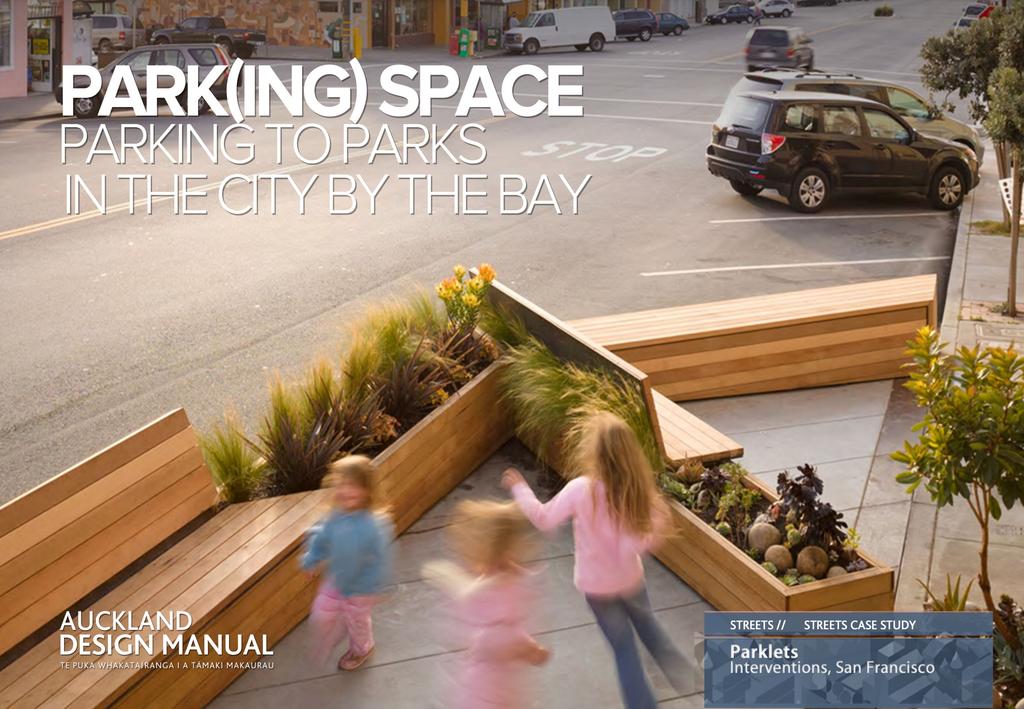
2 OVERVIEW Parklets are very small parks or mini-plazas that are constructed in on-street car parks. San Francisco s parklets programme provides inspiration for how we may use parking spaces to drive better community, environmental and economic outcomes in our neighbourhoods. Parklets are often constructed either where urban park areas are lacking or where footpaths are too narrow to provide adequate space. Parklets can radically improve a street environment by reclaiming parts of the street for pedestrians and bringing vibrancy to the immediate area. This Case Study looks at examples of excellent parklets in the city of San Francisco. PROJECT SUMMARY In 2009 San Francisco launched its Great Streets Project. Modeled on New York City s (NYC) Streets Renaissance its aim is to prove the multiple benefits of reclaiming road reserve for pedestrian usage. San Francisco s Great Streets Project initially worked with political and business leaders to test, analyse and institutionalise Placemaking within the road reserve. To this end parklets were one of the first types of demonstration project undertaken by NYC and San Francisco. The demonstration projects were not done in isolation. These cities were also developing large-scale public campaigns, detailed Strategies, Plans and Implementation schedules, in conjunction with extensive community consultation and engagement programmes, to bring about a culture change in how streets should be viewed and used. As stated by Enrique Penalosa, the former mayor of Bogota, Columbia who opened San Francisco s Great Street Project launch,..the amount of space allocated to cars is not fixed, but rather a political decision that can drastically reshape the city.. Rebar, a San Francisco firm, designed a parklet outside of Tony spizza Napoletanain the North Beach neighborhood. (Photo: SørenSchaumberg Jensen/REBAR) 2
3 KEY PROJECT INFORMATION STREET TYPE PROJECT EXTENT DESIGN TEAM PROJECT DATES VARIOUS 15m2 UPWARDS VARIES INITIATED IN 2010 Parklet s are often constructed on, or near retail streets, but have been built across a wide range of street types. Parklets can be as small as a single parking space, or extend over several parking spaces Design teams are appointed by the project initiator, and are usually landscape architects, artists and designers. Initial trial projects were initiated in 2010, and since then 30 + parklets have been developed across San Francisco. PROJECT TYPE KEY PROJECT WORKS CLIENT PROJECT COST STREET INTERVENTIONS DEMONSTRATION PROJECTS PARKLETS PROJECT DESCRIPTION SMALL,USUALLY TEMPORARY PARKS LOCATED IN CAR PARKING SPACES VARIES Located in on-street parallel car parks adjacent to the footpath. At least 2 car parks in size, often larger. Located outside retail or hospitality premises. Parking space is built up using a platform to same level as footpath. LOCAL BUSINESSES Projects are usually initiated and funded by businesses adjacent to the parking spaces, or local business associations. LOW COST OTHER FACTS In most cities (Park)ing Day is only one day. In San Francisco s fashionable Mission District mini parks have been occupying parking spaces for months at a time. 3

4 PROJECT GOALS 1. To improve the street experience by providing attractive, distinctive and artful areas for people to sit, relax, people-watch and enjoy. 2. To potentially benefit the adjacent businesses by bringing custom to the premises. 3. To provide street vitality where activities can extend from the footpath into the street. 4. To assist in meeting social, recreational and/ or ecological needs. 5. When carefully/strategically located, parklets can help slow street traffic and create more spaces for people on the street. 6. To provide additional public space in a cheap, and simple way. Photo: Courtesy San Francisco Planning Dept. (via Flikr) 4
 Day, an international effort to temporarily transform parking spots into public spaces, San Francisco launched its first experimental")
5 UNDERSTANDING THE DESIGN PROCESS 1. Following the example of European sidewalk cafes and Park(ing) Day, an international effort to temporarily transform parking spots into public spaces, San Francisco launched its first experimental parklet in March The first parklet in San Francisco was built in front of the Mojo Bicycle Café on Divisidero Street. Six more trial locations followed, and now dozens of parklets dot the city across many neighbourhoods 3. Parklets can be temporary, such as International Park(ing) Day, or more permanent. 4. It is necessary that the adjacent retail or hospitality premises are on board with the idea. Frequently the businesses pay for the parklet to be implemented. 5. A parklet re-purposes part of the street into a space for people. 6. Parklets provide public amenities such as seating, bike parking, art and planting, helping to meet the need for increased public open space, often in builtup areas. Overhead view of a café-related parklet on Polk St. in San Francisco. (Photo: 5

: Matarozzi Pelsinger")
6 GETTING IT RIGHT Photo (left): Courtesy San Francisco Planning Department. Photo (right): Matarozzi Pelsinger Builders & Wells Campbell photography. 6

: Courtesy of Scott")
7 GETTING IT RIGHT Photo (left): Courtesy San Francisco Planning Department and Tim Griffith. Photo (right): Courtesy of Scott Beyer. 7

8 GETTING IT RIGHT 1. DESIGN STREETS AS PUBLIC SPACES 1. The parklets are publicly accessible open spaces available for all to enjoy. 2. A parklet re-purposes part of the street into a space for people not in cars. 3. Parklets provide public amenities such as seating, bike parking, art and planting, helping to meet the need for increased public open space. 4. Parklets allow people to stop, rest, and enjoy life on the street, improving safety through simply ensuring more people are in the street nd St Parklet hosted by hosted Fabric8. August, 2011 (Photo: Courtesy San Francisco Planning Dept.) 8

9 GETTING IT RIGHT 2. DESIGN FOR CONTEXT 1. Most parklets are sponsored or paid for by the adjacent retailer or retailers as an (outdoor) extension of their business 2. This parklet provides seating and increased visibility for the adjacent general store. 3. The parklets has been strategically planned to ensure that it doesn t impinge on vehicular or pedestrian traffic. A clear section of pavement is maintained for pedestrians to walk through A typical parklet design physically extends the footpath, often with a deck, so that it becomes a part of the immediate public pedestrian zone The materials of this parklet, complete with sculptural tree trunk seating (far distance) echoes its host, the timber-fronted shop opposite. (Photo: Courtesy San Francisco Planning Department). 9

10 GETTING IT RIGHT 3. DESIGN FOR CONNECTIVITY 1. Although parklets don t generally improve physical connectivity, they can often enhance community connections, and economic relationship between adjacent businesses. 2. A few parklets located within easy walking distance of each other can form a connected network of places for a local area. 3. Parklets can be part of a wider programme to create a more pedestrian-friendly and connected local environment A centrally located parklet contributes to a more pedestrian-friendly and connected community. (Photo: SørenSchaumberg Jensen/REBAR) 10

11 GETTING IT RIGHT 4. DESIGN FOR SAFETY 1. Parklets and mini-plazas can contribute to making a safer street environment, by narrowing and calming vehicles. 1. Parklets offer opportunities for people to stop, relax and enjoy. More street life brings more eyes on the street and helps create a perception of safety. 2. Parklets often have boundary-defining elements planters, seating, edging -to protect visitors and clearly differentiate the parklet from the carriageway. 3. The psychological effect of positioning pedestrians in the road reserve is an uncertainty; therefore drivers travel with more care, and slower speeds Parklets allow more people to inhabit the street which significantly increases both actual, and the perception of, street safety. (Photo: San Francisco Planning Dept.) 11

12 GETTING IT RIGHT The extent of parklets can be formally or informally defined by way of the design. Credit: Ogrydziak Prillinger Architects (Photo: Tim Griffith -Courtesy San Francisco Planning Dept.) 12

13 GETTING IT RIGHT 5. DESIGN FOR ENVIRONMENTAL SUSTAINABILITY 1. Parklets are generally low cost and relatively straight forward to construct. This parklet reconfigures a skip to provide seating and green the street. 2. Parklets often provide enhanced environmental performance, supporting biodiversity, improving water retention to minimise stormwater run-off, or incorporating bike storage for more sustainable lifestyles Parklets are often temporary structures. This parklet could easily be lifted onto a truck and moved to another location within minutes, 4. Many parklets are easy to dismantle Relocate-able dumpster (skip) parklet. Photo: Flikr, Courtesy of San Francisco Planning Dept. 13

14 GETTING IT RIGHT 6. DESIGN AND PLAN STREETS TO BE FIT FOR PURPOSE 1. Parklets provide a Place function for streets that often have only a (vehicular) movement function. 2. Parklets help to redress the frequent car-pedestrian imbalance in some streets. 3. They are simple and straightforward to maintain; businesses and/or the local community often take informal ownership of theses public spaces Easily relocate-able dumpster (skip) parklets. Photo: Flikr, Courtesy of San Francisco Planning Dept. 14

15
parklets tiny parks with big impacts for city streets SvR Design Sarah Gould 12/21/12
 parklets tiny parks with big impacts for city streets SvR Design Sarah Gould 12/21/12 Not surprisingly, the close connection between people s use of city space, the quality of city space and degree of
TRANSFORMING THE PUBLIC REALM IN SAN FRANCISCO
 TRANSFORMING THE PUBLIC REALM IN SAN FRANCISCO NEW STRATEGIES FOR A NEW AGE 22nd Annual Building LIvable Communities Conference for Local Elected Officials Yosemite National Park, 03.16.2013 TRANSFORMING
Dogpatch/22nd Street Greening
 TEAM MEMBERS Prepared for: GreenTrustSF Central Waterfront www.gtsfcw.org Prepared by: Fletcher Studio San Francisco, CA www.fletcherstudio.com Landscape Architecture Urban Design Environmental Planning
DOWNTOWN NORFOLK COUNCIL ACTION PLAN. Strategic Initiatives Focus Area Objectives. Departmental Focus Area Key Objectives
 DOWNTOWN NORFOLK COUNCIL ACTION PLAN FY18 Strategic Initiatives Focus Area Objectives Departmental Focus Area Key Objectives STRATEGIC INITIATIVES FOCUS AREA OBJECTIVE #1: NURTURE A VIBRANT URBAN ENVIRONMENT
MISSION STREETSCAPE PLAN. Neighborhood Commercial Streets handle continuous activity. Neighborhood Commercial STREET ROW: Main Design Treatments
 Neighborhood Commercial STREET ROW: 64-80 Main Design Treatments CORNER reduce crossing distance for pedestrians, create entrances to a residential area and slow cars down. help widen sidewalk allocating
OVERVIEW OF PLANS FOR THE JEFFERSON COUNTY COUNTRYSIDE FARM In the Context of Quality Place Characteristics
 OVERVIEW OF PLANS FOR THE JEFFERSON COUNTY COUNTRYSIDE FARM In the Context of Quality Place Characteristics By Steve Grabow, Professor and Community Development Educator University of Wisconsin-Extension,
PARKLET AND FLEX SPACE DESIGN GUIDELINES AND SPECIFICATIONS
 PARKLET AND FLEX SPACE DESIGN GUIDELINES AND SPECIFICATIONS V1 AUGUST 2016 PROCESS - A ONE STOP SHOP Parklet design service Upgrade Relocate Build again Place facilitator outreach One-stop approval Build
MARKET STREET PARK COMMUNITY ENGAGEMENT SUMMARY. December 2018 MARKET STREET PARK COMMUNITY ENGAGEMENT SUMMARY
 MARKET STREET PARK COMMUNITY ENGAGEMENT SUMMARY December 2018 1 CONTENTS Introduction p.3 PART A: ENGAGEMENT OVERVIEW Project Context p.5 Engagement Snapshot p.6 Media Snapshot p.7 Engagement Outcomes
Program Schedule, Budget and Scope
 Sewer System Improvement Program + Program Schedule, Budget and Scope Mission & Valencia Green Gateway Presentation: July 9, 2013 San Francisco Public Utilities Commission Mission & Valencia Green Gateway
Throughout. square. (Crystal City Vision Plan 2050)
") 1: Terms related to the PSMP document 1 public space (see also public realm, civic space) An open space designated on the regulating plan, accessible to all, including Plazas, Mini Parks, and Neighborhoods
1: Terms related to the PSMP document 1 public space (see also public realm, civic space) An open space designated on the regulating plan, accessible to all, including Plazas, Mini Parks, and Neighborhoods
City of Hermosa Beach Administrative Policy #
 City of Hermosa Beach Administrative Policy # SUBJECT: Living Streets Policy Date: Approved by: City Council Authority: Public Works Department & Community Development Department Mayor, PURPOSE The City
PUBLIC RIGHT-OF-WAY IN THIS CHAPTER PUBLIC REALM
 PUBLIC RIGHT-OF-WAY This section provides design guidelines for improvements in the public right-of-way. The public right-of-way refers to streets, sidewalks, non-vehicular thoroughfares, parks and greenways
The Vision. Photo provided by The Minervini Group. 46 Vision, Objectives & Strategies
 Vision, Objectives & Strategies The is the public framework and guide for future development of the Grand Traverse Commons. The establishes public polices for infrastructure, the preservation of natural
UNION STUDIO Greater Kennedy Plaza!
 April May 2013 UNION STUDIO Greater Kennedy Plaza! It s time: Providence s civic plaza and transit hub is re-imagined as a vibrant urban gathering place 1 Kennedy Plaza Reborn THE TEAM Client: The City
7-PARKS, OPEN SPACE & PUBLIC ART
 7-s, Open Space & Public Art 7-PARKS, OPEN SPACE & PUBLIC ART This chapter provides recommendations for the expansion of new parks, plazas and open space that serve the many user groups targeted for downtown.
Chapter 2: OUTLINE PLANNING APPLICATION PROPOSALS. A New Garden Neighbourhood Matford Barton 17
 Chapter 2: OUTLINE PLANNING APPLICATION PROPOSALS A New Garden Neighbourhood Matford Barton 17 2.1. SUMMARY AND STATUS OF THE PROPOSALS 2.1.1. The parameter plans and associated wording in this chapter
Fifth and Detroit Street Design May 2017 Capital Improvements Committee. DOWNTOWN Street Design
 1 Fifth and Detroit Street Design May 2017 Capital Improvements Committee Agenda 2 Review Street Configuration Prior Meeting Review Outreach Synopsis Functional Street Design Refinements Curb Edge, Turning
This Review Is Divided Into Two Phases:
 Semiahmoo Town Centre Review The purpose of this review: To review the Semiahmoo Town Centre Concept Plan, originally approved in 1993, to ensure that this centre will continue to serve the needs of South
W O R K S H O P S U M M A R Y. Community Workshop #1: Visioning September 11th, 2007
 W O R K S H O P S U M M A R Y Community Workshop #1: Visioning September 11th, 2007 Upper Market Community Workshop Series and Design Plan Page 1 of 9 INTRODUCTION The Upper Market Community Workshop Series
3.1 community vision. 3.3 required plan elements
 Chapter 3 Community Form 3.1 community vision 3.2 Parks & landscaping concepts 3.3 required plan elements D R A F T 20 Community Form Chapter 3 3.0 Community form 3.1 community vision The Specific Plan
ILLUSTRATIVE MASTERPLAN
 ILLUSTRATIVE MASTERPLAN The Development Dairy Crest (Imperial College) The Proposed Development aims to create a new high quality residential neighbourhood, alongside a new public park for White City.
East Grove Public Realm
 H - - MP - Elephant Park Public Realm RO EY DN NEW KENT ROAD E AC PL The public realm has been designed to create an environment which is easy to move through, accessible to all, safe and playful. The
P A R K L E T 2016 PILOT PROJECT
 GRAND FORKS, NORTH DAKOTA P A R K L E T 2016 PILOT PROJECT City of Grand Forks Planning & Community Development Department LIVE, LEARN, WORK, PLAY, AND STAY The purpose of the Grand Forks Parklet Application
10.0 Open Space and Public Realm
 10.0 Open Space and Public Realm 10.0 Open Space and Public Realm The Public Open Space System is comprised of: outdoor spaces available for public use that are either publicly owned (e.g., parks and
Market Place Bythell Place Queen Street Park Riverside Park. Public Spaces. Blenheim CBD Streetscape Final Report 36
 37 39 41 43 Market Place Bythell Place Queen Street Park Riverside Park Final Report 36 Market Place Market Place is a key space for Blenheim s street life, it is a meeting place, retail edge and pedestrian
General Manager, Planning and Development; General Manager, Parks, Recreation and Culture. Proposed Mini-Park and Plaza Designations
 Corporate NO: R106 Report COUNCIL DATE: June 16, 2008 REGULAR COUNCIL TO: Mayor & Council DATE: June 12, 2008 FROM: SUBJECT: General Manager, Planning and Development; General Manager, Parks, Recreation
Roanoke Rapids Streetscape Master Plan. City Council Presentation
 SCHEDULE: Stakeholder Meeting/Kick off November,2016 Master Planning Phase (November March 2017) Public Meeting #1 December 13, 2016 Review Meeting with Key Stakeholders Refine Concepts Based on Input
VEHICULAR AND PEDESTRIAN CIRCULATION
 This perspective sketch communicates the intended character and quality of a proposed streetscape design. Locate benches near a major intersection where people tend to gather. Seating and lighting provide
Shared Principles and Emerging Plan Directions
 Shared Principles and Emerging Plan Directions Introduction Since the Fairfield Neighbourhood planning process launched in June 2016, we have heard from many residents, businesses, groups and other people
STREETSCAPE IMPROVEMENTS - RECOMMENDATIONS
 STREETSCAPE IMPROVEMENTS - RECOMMENDATIONS Figure 4.3.1- A map of all of the recommended streetscape improvements. The key component of downtown s public realm, apart from its public spaces, is its street
Urban Design & Placemaking
 Urban Design & Placemaking What is Urban Design? Urban Design is the discipline of creating equitable, vibrant, and sustainable places with distinct identities. The profession pulls from other built environment
Jenifer Street Reconstruction Neighborhood Engagement Meeting November 4, 2015
 Jenifer Street Reconstruction Neighborhood Engagement Meeting November 4, 2015 Hosted by the Marquette Neighborhood Association Facilitated by Urban Assets Funded in part by the City of Madison Neighborhood
Place Brief. National Collections Facility (NCF site)
") Place Brief. National Collections Facility (NCF site) Contents 1.0 Purpose 2.0 Location and Proposal 3.0 Vision and Aim 4.0 Placemaking Principles 5.0 Conclusion Plan 1 Location Plan Plan 2 Placemaking
Place Brief. National Collections Facility (NCF site) Contents 1.0 Purpose 2.0 Location and Proposal 3.0 Vision and Aim 4.0 Placemaking Principles 5.0 Conclusion Plan 1 Location Plan Plan 2 Placemaking
PIKE PINE RENAISSANCE: ACT ONE. October 19, 2017
 PIKE PINE RENAISSANCE: ACT ONE October 19, 2017 WATERFRONT SEATTLE PROGRAM PROJECT INTRODUCTION Pike and Pine streets, between First and Melrose avenues Pedestrian and streetscape improvements Budget:
ANC 2A Presentation. November 9, 2006
 ANC 2A Presentation November 9, 2006 Introduction & Overview Applicants Boston Properties and KSI Services (project developers) The George Washington University (land owner) 2.66 acre site (former GW hospital
PROPOSED REDEVELOPMENT OF THE GLEN ABBEY GOLF CLUB. STREETSCAPE DESIGN STUDY (excerpt from the Urban Design Brief) TOWN OF OAKVILLE.
 TOWN OF OAKVILLE.") PROPOSED REDEVELOPMENT OF THE GLEN ABBEY GOLF CLUB STREETSCAPE DESIGN STUDY (excerpt from the Urban Design Brief) TOWN OF OAKVILLE OCTOBER, 2016 for 2.4.2 STREETS Streets are the single largest component
PROPOSED REDEVELOPMENT OF THE GLEN ABBEY GOLF CLUB STREETSCAPE DESIGN STUDY (excerpt from the Urban Design Brief) TOWN OF OAKVILLE OCTOBER, 2016 for 2.4.2 STREETS Streets are the single largest component
Draft for Public Review. The Market and Octavia Neighborhood Plan
 Draft for Public Review The Market and Octavia Neighborhood Plan San Francisco Planning Department As Part of the Better Neighborhoods Program December 2002 IOverview Why Plan a Better Neighborhood Here
MEMO 1. INTRODUCTION PURPOSE & PROCESS REQUEST
 MEMO Date: August 22, 2017 To: Board of Commissioners From: Jason Burdette, Planning Director Re: Davidson Commons East Hotel Stakeholder Feedback 1. INTRODUCTION PURPOSE & PROCESS This memorandum summarizes
Engagement Summary Gastown Streets: Local Business Visioning Workshop
 Engagement Summary Gastown Streets: Local Business Visioning Workshop Gastown s streets are in need of major repair and rehabilitation and we have a once in a lifetime opportunity to holistically plan
Neighborhood Districts
 NEIGHBORHOOD DISTRICTS SEVEN MAIN DISTRICTS Neighborhood Districts While the Development Plan provides a broad-scale overview of the neighborhood, this section focuses on uses and relationships at the
ITEM #8. Regional Smart Growth Program. Regional Smart Growth Program. Presentation Overview. Coast Highway Vision and Stategic Plan.
 Regional Smart Growth Program Economic Development Commission What is Smart Growth? Adopted as part of the Regional Comprehensive Plan (RCP) RCP provides vision for region based on Smart Growth and sustainability
Chapter 4. Linking Land Use with Transportation. Chapter 4
 Chapter 4 Linking Land Use with Transportation Chapter 4 59 Chapter 4 Linking Land Use with Transportation Community Design and Transportation Program Introduction Since the 1950s, the predominant development
Marpole Community Plan. Parks and Open Space
 Marpole Community Plan Parks and Open Space Community Workshop, March 13 th, 2013 Overview 1 Community Plan 2 City-wide initiatives 3 4 Overview 1 Community Plan 2 City-wide initiatives 3 4 Marpole: Boundaries
GREENING THE BOULEVARD Master Plan Concepts for Venice Boulevard between Lincoln and Sawtelle
 GREENING THE BOULEVARD Katherine Spitz Associates Inc. 4212½ Glencoe Avenue Marina Del Rey, CA 90292 310 574 4460 Fax 574 4462 January 2008 Table of Contents Overview Proposed Design Improvements Illustration
Ann Arbor Downtown Street Design Manual. Ann Arbor DDA IDA 2015 Awards Planning Category
 Ann Arbor Downtown Street Design Manual Ann Arbor DDA IDA 2015 Awards Planning Category 1 Ann Arbor s downtown streets are vibrant public spaces that accommodate multi-modal transportation, special events,
Appendix H: Easement cross sections
 Appendix H: Easement cross sections SHARED PATH 1.5m FOOTPATH NATURE STRIP 7.3m CARRIAGEWAY 2.7m NATURE STRIP EXISTING PIPELINE 150mm DIA 5.0m (approx.) LOCAL ACCESS ROAD EXISTING PIPELINE 500mm DIA 2.7m
Davis Landscape Architecture. Davis. Landscape Architecture
 23a Iliffe Yard, London, SE17 3QA, UK +44 (0)20 7277 1035 mail@davisla.com www.davisla.com Practice Overview We are a design led London based practice that prides itself on the delivery of schemes that
Completing the Vision:
 Completing the Vision: North A1A-Lane Reconfiguration TDLC-Transportation Design for Liveable Communities Surf Rd. Redirection of Traffic Phase III Streetscape October 30, 2012 1 Project Overview District
(DC1) Direct Development Control Provision DC1 Area 4
 Direct Development Control Provision DC1 Area 4") . General Purpose (DC) Direct Development Control Provision DC Area 4 The purpose of this Provision is to provide for an area of commercial office employment and residential development in support of the
. General Purpose (DC) Direct Development Control Provision DC Area 4 The purpose of this Provision is to provide for an area of commercial office employment and residential development in support of the
ANCHOR TO ANCHOR. Rescale the street to create an iconic boulevard.
 ANCHOR TO ANCHOR Rescale the street to create an iconic boulevard. UR NE ER UV GO NE LA OBJECTIVES 1. Maintain appropriate traffic flow and prioritize commercial curb access 2. Mark gateways at the street
PUTTING THE HEART INTO BATTERSEA. A vision
 PUTTING THE HEART INTO BATTERSEA A vision INTRODUCTION This document is a vision for creating a Battersea that its community can be proud of and it is about putting Battersea on the map. It is being proposed
Table of Contents. Executive Summary... vii
 Table of Contents Executive Summary... vii Section I: Background...1 Introduction... 3 Study History... 3 Purpose and Role of the Plan... 6 Plan Organization... 7 The Estuary Shoreline... 11 Multiple Jurisdictions...
BLOK BADEL ZAGREB. Competition for the urban-architectural concept design for the BADEL SITE redevelopment COMPETITION NUMBER: ZG-UA
 BLOK BADEL ZAGREB Competition for the urban-architectural concept design for the BADEL SITE redevelopment COMPETITION NUMBER: 136-12-ZG-UA 1.0 DESCRIPTION AND EXPLANATION OF THE OVERALL CONCEPT The Badel
Proposed new Tasmanian Planning Scheme what it will mean
 Please share this article with your networks, politicians, community leaders and interested others. This article is supported by the Tasmanian Planning Information Network (www.taspin.net) and Blackmans
Gas Stations ottawa.ca
 Urban Design Guidelines for Gas Stations ottawa.ca Ce document est disponible en français sur ottawa.ca. This document is available in French on ottawa.ca. Approved by City Council May 24, 2006 City of
The principal elements of the NTC Strategic Vision plan are as follows.
 The proposed project would improve the NTC site plan, circulation, visitor amenities, and landscaping, and would include construction of two new stadiums to replace the existing Louis Armstrong Stadium
PLAN ELEMENTS WORKSHOP. April 5, 2016
 PLAN ELEMENTS WORKSHOP April 5, 2016 needs more housing. But there is no one-size fits-all solution. Every neighborhood has its own character. In some places, density is not only appropriate it is badly
Subregion 4 Central Avenue-Metro Blue Line Corridor Transit-Oriented Development (TOD) Implementation Project. Community Meeting April 27, 2011
 Implementation Project. Community Meeting April 27, 2011") Subregion 4 Central Avenue-Metro Blue Line Corridor Transit-Oriented Development (TOD) Implementation Project Community Meeting April 27, 2011 Overview Introduction to Subregion 4 TOD Implementation Program
Subregion 4 Central Avenue-Metro Blue Line Corridor Transit-Oriented Development (TOD) Implementation Project Community Meeting April 27, 2011 Overview Introduction to Subregion 4 TOD Implementation Program
Horwood Map of London, Westminster & Southwark First edition
 Barratt London is developing plans in tandem with Southwark Council and TfL to transform the southern end of Blackfriars Road. The residential-led, mixed-use scheme will deliver new private and affordable
Short-Term Action Long-Term Change
 Short-Term Action Long-Term Change A Workshop For: Downtown Revitalization & Management Institute s Designing Downtown NOW! Real Tactics and Tools to Enhance Your Businesses and Districts July 25, 2012
SECTION ONE North East Industrial Zone Design Guide Palmerston North City Council June 2004
 SECTION ONE North East Industrial Zone Design Guide Palmerston North City Council June 2004 young heart easy living 1 Preface Industrial areas are a very important component of the economic well-being
H7 Open Space zones. (a) provide for the needs of the wider community as well as the needs of the community in which they are located;
 provide for the needs of the wider community as well as the needs of the community in which they are located;") H7. Open Space zones H7.1. Background The majority of land zoned as open space is vested in the Council or is owned by the Crown. However some areas zoned open space are privately owned. While the open
H7. Open Space zones H7.1. Background The majority of land zoned as open space is vested in the Council or is owned by the Crown. However some areas zoned open space are privately owned. While the open
Sustainability, Health, Safety, Recreation & Open Space Working Group August 3, 2017
 Sustainability, Health, Safety, Recreation & Open Space Working Group August 3, 2017 DOWNTOWN OAKLAND SPECIFIC PLAN WELCOME Sustainability, Health, Safety, Recreation & Open Space Working Group Social
Design & Access Statement
 PI 007 RIBA Chartered Architects Design & Access Statement Ocean Beach Pleasure Park South Shields 1.0 Appraising the Context 1.1 Assessment of the sites immediate and wider context 1.2 Involvement Consultation
POP-UP CITY. City of Seaside Gloria Stearns Sharon Mikesell
 POP-UP CITY City of Seaside Gloria Stearns Sharon Mikesell What is the plan for the next 30 minutes? Definitions, examples, learning Some fun along the way Hopefully Resources Questions & answers What
North Oakville East Parks Facilities Distribution Plan. November, 2009
 North Oakville East November, 2009 POLICY CONTEXT 1) Purpose a) The purpose of this document is to be a guide for the location, configuration, design and development of the parks system for the North Oakville
Bridgeport Comprehensive Waterfront Plan 2 nd Launch Neighborhood Meeting 3/9/16
 CivicMoxie 2016 #WaterfrontBPT @CivicMoxie Bridgeport Comprehensive Waterfront Plan 2 nd Launch Neighborhood Meeting 3/9/16 City of Bridgeport OPED, Department of Planning Bridgeport s greatest asset is
RECLAIMING PUBLIC SPACE
 RECLAIMING PUBLIC SPACE INTRODUCTION PRECEDENT STUDIES AREAS OF FOCUS VISION IMPLEMENTATION CHURCH ST WEST END AVEBROADWAY BROADWAY DIVISION ST DEMONBREUN ST Reclaiming Public Space Like most cities, Nashville
SAFETY BY DESIGN Drives Successful Urban Greenways. Brian Charlton - SGJJR Mac McCracken - DRFC
 SAFETY BY DESIGN Drives Successful Urban Greenways Brian Charlton - SGJJR Mac McCracken - DRFC WORLD-CLASS GATHERING PLACE FOR ALL. Detroit Greenways Atwater Street and Rivard Street 2003 Atwater Street
Horizon 2035 Land Use and Transportation Element
 CITY OF SUNNYVALE Horizon 2035 Land Use and Transportation Element City Council Study Session March 7, 2017 Overview General Plan Context Mixed Use Villages Transportation Mode & Parking General Plan Policy
Downtown Lead Revitalization Project Final Recommendations. Three Proposed Options for the Revitalization of Downtown Lead
 Downtown Lead Revitalization Project Final Recommendations Three Proposed Options for the Revitalization of Downtown Lead November 1, 2011 Three Proposed Options for the Revitalization of Downtown Lead
FULL WORKING GROUP MEETING
 11/06/17 FULL WORKING GROUP MEETING Excelsior and Outer Mission Neighborhood Strategy Rachael A. Tanner, Planning Department 11/06/2017 Jorge Rivas Jr., Office of Economic and Workforce Development CONTENTS
PLACEMAKING & MOBILITY WORKSHOP. January 27, 2016
 PLACEMAKING & MOBILITY WORKSHOP January 27, 2016 Boston needs more housing. But there is no one-size fitsall solution. Every neighborhood has its own character. In some places, density is not only appropriate
The Economic Value of Public Space/ Case Studies
 Project for Public Spaces Placemaking and the Future of Cities Fall 2012 "Parks and squares can sometimes be viewed as a frivolity, an unnecessary drain on resources or use of precious urban space. Nothing
People Oriented Mobility and Urban Development
 Ola Gustafsson Director & Team Lead Stuttgart June 18 2018 People Oriented Mobility and Urban Development Gehl makes cities for people We are a team of dynamic, talented, international people from varying
Section4 Design Vision & Implementation Plan
 Section4 Design Vision & Implementation Plan W Woodschurch Rd 4.1 Design Focus Areas The Framework Plan is simply the starting point for directing the design and implementation of a wide range of transportation
Pedestrian and Bike Bridge LOGO
 6.2.2 Pedestrian and Bike Bridge The proposed pedestrian and bike crossing re-envisions the existing bridge at Pismo Creek on Cypress Street. The bridge is currently underutilized by vehicular through
Gateway commercial MIXED USE MASTER SITE PLAN. CITILAND AIrDRIE GATEWAY VENTURE INC. airdrie GATEWAY COMMERCE CENTRE. airdrie, ALBERTA FEBRUARY 2012
 Gateway commercial MIXED USE MASTER SITE PLAN 1914 CENTRE STREET NORTH CALGARY, AB CANADA T2E 2S8 T. 403.264.7177 F. 403.264-7175 WWW.CITILAND.CA CITILAND AIrDRIE GATEWAY VENTURE INC. airdrie GATEWAY COMMERCE
Bayshore Boulevard Home Improvement District Design Guidelines
 Bayshore Boulevard Home Improvement District Design Guidelines guidelines for New construction projects and major alterations IN the bayshore boulevard home improvement special use DISTRICT SAN FRANCISCO
Welcome. /The Design Companion 4. /Planning London 7. /Getting Homes Built 8. /Transport & Streets 10. /Tech & The City 12
 Welcome With the draft publication of the London Plan and the Mayor s Transport Strategy (MTS) this year s events programme will examine both documents in detail with a wide range of seminars, debates
Brozen & Loukaitou-Sideris 1. TITLE Reclaiming the Right-of-Way Best Practices for Implementing and Designing Parklets
 Brozen & Loukaitou-Sideris 0 0 TITLE Reclaiming the Right-of-Way Best Practices for Implementing and Designing Parklets AUTHORS Madeline Brozen, Program Manager Complete Streets Initiative UCLA Luskin
WEST LOOP DESIGN GUIDELINES CHECKLIST
 WEST LOOP DESIGN GUIDELINES CHECKLIST Section 1.0 General Strategies 1.1 DESIGN EXCELLENCE: ENCOURAGE HIGH QUALITY AND INNOVATIVE DESIGN OF NEW BUILDINGS WITHIN THE WEST LOOP WITHOUT BEING PRESCRIPTIVE
03 HIGH PRIORITY SITES
 03 HIGH PRIORITY SITES HOWARD PARK Howard Park is one of South Bend s largest riverfront parks, hosting nearly acres. Howard Park has a very passive landscape with a recreation building, ice skating rink,
Urban Planning and Land Use
 Urban Planning and Land Use 701 North 7 th Street, Room 423 Phone: (913) 573-5750 Kansas City, Kansas 66101 Fax: (913) 573-5796 Email: planninginfo@wycokck.org www.wycokck.org/planning To: From: City Planning
Topham Mall, Bentham, Pitt and Waymouth Street Place Plan
 The Adelaide City Council invites engagement from the community about Topham Mall, Bentham, Pitt and Waymouth Street Prioritising the top priorities for the area Topham Mall, Bentham, Pitt and Waymouth
Scottish Natural Heritage. Better places for people and nature
 Scottish Natural Heritage Better places for people and nature Contents Summary... 3 SNH approach... 5 Place-making in policy and practice... 6 Developing the contribution of the natural heritage to place-making...
FONTANA URBAN GREENING
 FONTANA URBAN GREENING MASTER PLAN COMMUNITY WORKSHOP #1 DECEMBER 17th, 2018 GOALS Fontana Forward Comprehensive Plan Urban Greening Master Plan State/Local Landscape Regulations Fontana Active Transportation
A ROADMAP FRAMEWORK FOR EAST BIRMINGHAM
 A ROADMAP FRAMEWORK FOR EAST BIRMINGHAM A PRESENTATION BY STEFAN WEBB SCOTT CAIN JON BRODERICK 18 SEPTEMBER 2015 METHODOLOGY 1: TRADITIONAL APPROACH A ROADMAP FRAMEWORK FOR EAST BIRMINGHAM 2 METHODOLOGY
Downtown North Las Vegas Demonstration Site Project. Project Update
 Downtown North Las Vegas Demonstration Site Project Project Update 7.16.14 Presentation Overview Project Purpose and Process Planning Context Opportunities and Barriers Summary Community Input Preliminary
Chapter 13 Residential Areas: Appendices APPENDIX 1 Residential Areas
 Chapter 13 Residential Areas: Appendices Page 1 Chapter 13 Residential Areas: Appendices APPENDIX 1 Residential Areas Design Code for Intensive Housing INTRODUCTION DESIGN ELEMENTS A NEIGHBOURHOOD DESIGN
Community Design Guidelines. Port Wallace DRAFT
 Community Design Guidelines Port Wallace DRAFT Energy 1 2 3 Nature Movement Connections Built Form DRAFT Layout Energy 1 Nature Community Design Guidelines GREAT COMMUNITIES PROTECT, CELEBRATE, AND CONSERVE
[PLANNING RATIONALE] For Site Plan Control and Lifting of Holding Zone By-Law 101 Champagne Avenue. May 23, 2014
![[PLANNING RATIONALE] For Site Plan Control and Lifting of Holding Zone By-Law 101 Champagne Avenue. May 23, 2014](/thumbs/75/71599615.jpg "[PLANNING RATIONALE] For Site Plan Control and Lifting of Holding Zone By-Law 101 Champagne Avenue. May 23, 2014") [PLANNING RATIONALE] For Site Plan Control and Lifting of Holding Zone By-Law 101 Champagne Avenue May 23, 2014 Contents 1.0 Introduction... 2 2.0 Site Context... 2 2.1 Adjacent Uses... 2 Figure 1: Site
[PLANNING RATIONALE] For Site Plan Control and Lifting of Holding Zone By-Law 101 Champagne Avenue May 23, 2014 Contents 1.0 Introduction... 2 2.0 Site Context... 2 2.1 Adjacent Uses... 2 Figure 1: Site
SFMTA PHELAN LOOP AND PUBLIC PLAZA PHELAN OCEAN AVENUE
 SFMTA Municipal Transportation Agency Image: a bus in front of the Palace of the Legion of honor SFMTA PHELAN LOOP AND PUBLIC PLAZA PHELAN AVENUE @ OCEAN AVENUE Community Meeting May 23, 2012 San Francisco,
I615. Westgate Precinct
 I615. Westgate Precinct I615.1. Precinct Description The Westgate Precinct is located approximately 18km west of the Auckland city centre. There are seven Sub-precincts in the Westgate Precinct: Sub-precinct
97 Lea Bridge Road, Leyton, E10 7QL London Borough of Waltham Forest December 2015
 97 Lea Bridge Road, Leyton, E10 7QL London Borough of Waltham Forest December 2015 Public Realm and Landscape Proposals LEA BRIDGE ROAD, WALTHAMSTOW Public Realm & Landscape Proposals BDP(90)RPT001 December
COMPLETE GREEN STREET CHECKLIST
 COMPLETE GREEN STREET CHECKLIST This document was developed to dissect the structure of an urban street and explore opportunities to make our streets more complete while also integrating green street strategies.
Mill Conversion Overlay District Zoning Bylaw Amendment
 Mill Conversion Overlay District Zoning Bylaw Amendment To see if the Town will vote to amend the Zoning By-Law by adding a new Section 13, Mill Conversion Overlay District, and by amending Sections 2.1,
Public Consultation Summary: Lakeview Place Making Workshop January 30, 2008.
 Page 1 of 11 Public Consultation Summary: Lakeview Place Making Workshop January 30, 2008. 1.0 Introduction: On January 30, 2008 the City of Mississauga, in conjunction with the consulting team of Brook
Local Placemaking Opportunities
 What if We Built Elmira Around Places? Elmira Downtown Development Annual Meeting April 26, 2006 Planning & Design PPS Highlights 48 states, 24 countries 1200 communities 1 million visitors to our web
4.0 URBAN DESIGN FRAMEWORK. The vision for the future development of the plan area is to:
 4.0 The vision for the future development of the plan area is to: Create a new neighbourhood that focuses on the highly valued natural and aesthetic features of the lands and provides good quality homes,