Experiences of dealing with Lesser Horseshoe Bats (Rhinolophus
|
|
|
- Penelope Brown
- 6 years ago
- Views:
Transcription
1 Experiences of dealing with Lesser Horseshoe Bats (Rhinolophus hipposideros) in Wales, UK Len Wyatt Environmental Science Advisor, Transport, Housing and Strategic Regeneration, Welsh Assembly Government, UK Bats and Road Planning, Köln, Germany. June 2010 Bats and Road Planning, Koln, Germany. June 2010
2 The Presentation Aim The Context Our Network The Context Lesser Horseshoe Bats in the UK The Context Lesser Horseshoe Bat flight behaviour Case Studies Principles 1 Surveying Considerations Principles 2 Design Considerations Principles 3 Monitoring Considerations Conclusions Acknowledgements Emphasis on practical measures, general principles and the importance of understanding context. For all slides bat flight paths are shown by - Welsh Assembly Government Working Together for Wales
3 Aim To explain the context in which the Welsh Assembly Government works. To provide information on some of the mitigation measures for Lesser Horseshoe Bats (Kleine hufeisennase) we have provided* To provide principles which have informed our work Further details and other information are provided within the paper associated with this presentation. *Please note my view is that the measures here may not work in situations where the context is different. Welsh Assembly Government Working Together for Wales
4 The Context 1 Our Network Wales covers 20,779 sq km Our network is c.1700km Majority of network is single carriageway width of carriageway without verges and hard strips c7.3m There are 2 motorways in South Wales, and the majority of dual carriageways are in north and south Wales. In many areas geology and landscape means that network follows river valleys between mountains and hills the valleys also provide the best areas of Lesser Horseshoe Bats. Welsh Assembly Government Working Together for Wales

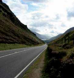
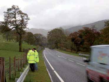
5 Views of our network
6 The Context 2 Lesser Horseshoe Bats in the UK UK Population 15,000 to 24,000 individuals About half of UK population is in Wales Use a variety of locations for roosts and hibernacula.including bridges, 300mm drainage pipes in road surface (rare?), crevices in rocks (rare?) Habitats for feeding woodland and scrub, vegetated river corridors, grassland/wet grassland close to flight routes or other vegetation Features to guide movements well connected hedgerows/woodland edges, rivers, streams, wire fencing/stone walls..underpasses and tunnels. Large number of legislative requirements from EC and UK have to met before a project can go ahead. Welsh Assembly Government Working Together for Wales


7 Locations where we have found lesser horseshoe bats Dia 1.5m In bridges like this one
8 The Context 3 Lesser Horseshoe Bat flight behaviour A reluctance to fly across open areas. Details of how wide a gap can be crossed - unknown Avoidance of street lights and lit areas. Details of strength of lighting which will not be avoid - unknown Fly high over traffic using tree canopies/crowns or if not available, will fly between 0.5 and 1.5m above a road. Fly up and down linear features alongside road Will use same routes to get to locations. Length of time before will change route if the route is changed unknown. Welsh Assembly Government Working Together for Wales
9
10 Case Studies 11 Case studies are presented with the following information: Location Map General Context of the situation Picture/description of the mitigation Results of Monitoring The Case Studies relate to large new infrastructure projects. Welsh Assembly Government Working Together for Wales
11 Case Studies: 1,2 and 3 A465 Section 1 Abergavenny to Hirwaun
12 Case Studies 1,2 and 3 Widening of existing road (3 lanes) to dual carriageway (4 lanes) Maternity roost of c90 individuals with 300m Bats flew regularly under and possibly over the existing road to reach feeding and other breeding areas. Baseline surveys up to 2004, then ongoing monitoring from 2006 Welsh Assembly Government Working Together for Wales
13 Concern that other mitigation measures were insufficient Creation of feeding habitat on roost side of road by slowing down stream, building shallow pond, managing area for insects and planting of insect friendly shrubs and trees. Approximately 2.2ha Created 2008 Case Study 1 New habitat Monitoring so far shows slow uptake in use of area. 1 or 2 individuals per year. Welsh Assembly Government Working Together for Wales


14 Excavating shallow pond Planting new trees/shrubs
15 Case Study 2 Extended underpass Concern about risk that existing safe flight path would be affected by extension, and increased risk of collisions with vehicles Extension of existing underpass phased to be carried out during winter season and when other flight paths under the road were not being altered. Plastic guide fencing and trees also installed c individual movements recorded over one night before construction. Monitoring showed similar numbers of movements, with occasional small alterations, probably not related to the road. Welsh Assembly Government Working Together for Wales

16 4.2m To roost 3.5m Before construction

17 During construction note replacement trees Width of new culvert 2.4m
18 Case Study 3 Grilles in underpass The new underpass in Case Study 2 needed to be protected from damage and people falling accidently into the tunnel. Installation of 2 metal grilles at entrances Original location across entrances to underpass installed in 2008 stopped bats completely. Test carried out with wood grilles had to be halted due to vandalism. Final set installed c1m from entrances in tunnel in Monitoring found bats confused by grilles two bars taken out, passed through safely. Will the bats get used to bars in 2010? Welsh Assembly Government Working Together for Wales

19 c.1.2m 130mm With all 2.5mm dia bars in currently fewer bats go through.how long before they learn?
20 Case Study: 4 A477 Sageston to Redberth Improvement
21 Case Study 4 New bat underpasses Single carriageway bypass of two villages Surveys during construction in 2001 found more bat activity than expected. Risk of loss of flight paths and risk of collisions with vehicles. Installation of 2.2m and 2m culverts on exact flight paths. Size chosen as maximum possible to fit in. Embankment excavated to form entrance and shrubs planted to link into surrounding countryside. Monitoring Majority of bats used underpasses although one few over road. No road casualties recorded during survey period. Welsh Assembly Government Working Together for Wales

22 2.2m elliptical Please note small sample size in surveys

23 2m elliptical Please note small sample size in surveys
24 Case Studies: 5 and 6 A479 Talgarth Relief Road
25 Case Studies 5 and 6 New underpass and construction fencing Single carriageway bypass and improvement of existing road to remove traffic from centre of town. Maternity roosts found in an old hospital and farms around the town. Circular flightpath around the edge of town using woods, hedgerows, large trees and a river. Surveys found 10 to 17 individual movements along stream through existing culvert and through canopy of trees. Culvert also used by badger (Meles meles) and otter (Lutra lutra) Welsh Assembly Government Working Together for Wales
26 Case Study 5 New underpass Concerned about damage to flight lines and risk of collisions with vehicles after removal of hedgerow and trees. New underpass constructed 15m from existing culvert, outside flight periods in winter 2006/7 and kept open during flight period Monitoring ongoing since Activity levels similar to before construction. At first bats split between culverts and trees. Removal of branch in 2007/8 eventually moved all bats to use culverts. Welsh Assembly Government Working Together for Wales

27 Existing culvert 0.9m wide

28 New culvert, with existing culvert in background 2.5m dia

29 One of 2 flightlines across or under construction footprint this one in canopy of trees. Flightline stopped by removing branch bats changed to using the other flightline through culverts
30 Case Study 6 Construction fencing Risk of damage to flightlines during construction Plastic fencing on metal frames moved away from site during the day, and returned at night, during the bats flight period.* Monitoring in 2006/7 showed similar numbers of bats using route as before construction. *Some UK advisors do not agree with providing temporary construction fencing. Consideration needs to be given to individual circumstances. Welsh Assembly Government Working Together for Wales

31 Construction fencing leading from New culvert 2.5m diameter to remaining vegetation. Gap distance c40m.
32 Case Studies: 7,8,9 and 10 A487 Llanwnda to South of Llanllynfi Improvement
33 Case Studies 7, 8, 9 and 10 Bat flight line measures Single Carriageway to bypass three villages Main roost 2.1km is a Natura 2000 site. September individuals at the roost. Surveys during construction 2001 found more activity than expected at a number of locations. Radiotracking (2002/3) confirmed bats travelling across the road using hedgerows/trees to feeding areas, and roosting/hibernacula sites. Monitoring ongoing since 2001 of flightpaths, mitigation; and casualties (daily between August to November). Welsh Assembly Government Working Together for Wales
34 Case Studies 7 Bollard lighting Monitoring during construction found 20 to 84 bat movements, rather than the 2 recorded before. 6 lesser horseshoe bat road casualties found within first year Trial (2002) and then installation (2003) of Bollard lighting Holophane Denver compact fluorescence. Planting and guide fencing also installed at bottom of embankment to guide bats along diverted stream to new bridge. Numbers of movements at lighted area reduced to zero in Increased movements at bridge and other crossing points. No further casualties at this point. Damage in 2007 to bollards created dark corridor occasional surveys found that bats did not return. Our approach is to use lighting as a last resort, after considering other options. Welsh Assembly Government Working Together for Wales

35 Bollard lights on both sides of road

36 Bats diverted by lighting use this bridge and crossing points to the north.
37 Case Study 8 Fencing to block flight lines Surveys during construction had found 1 to 8 movements per survey event in two locations even though new culvert (2m diameter) and new vegetation in place. Approximately 1 to 2 casualties per year during 2001/2 at both locations. Installation of 2m and 4m high fencing. 2m high fencing had 1 or 2 extensions added. Monitoring quickly showed bats adjusted flights to fly up, around and down the fencing. Welsh Assembly Government Working Together for Wales

38 4m fencing


39 2m high fencing with double extensions
40 Case Study 9 Ski jump Following the shift of the flightline by the lighting bollards, numbers of movements at this location increased (up to 39 movements), with only 1 casualty so far (2003). Casualties occurring nearby with fewer movements. Bats use of the gap in the trees and the vegetation suggested this crossing point could be made a preferred crossing point in the longer term. Earth bank and large trees provided within grass area on one side of road (2004) Recent monitoring has shown numbers dropped to between 2 and 12 at this point wet summers 2007/8/9? Small numbers of casualties at locations nearby. Bats found to use ski jump then return to ground level see Case Study 10. Welsh Assembly Government Working Together for Wales

41 Cycle way to ski jump

42 ski jump Existing trees other side of road
43 Case Study 10 T bat bridge Ski-jump (Case Study 9) was not working. Up to 39 individuals per year crossing at this point before decision was made, numbers have since dropped. Casualties at locations nearby. Existing vegetation suggested link between vegetation may be a long term option. T shaped bridge. Mesh 50mm x 50mm. Installed January 2010 monitoring just started. Welsh Assembly Government Working Together for Wales

44 T shaped bridge. Ski-jump on left hand side of bridge 5.7m clearance

45 Bat bridge in side profile 2m x 2m

46 Case Study: 11 A487 Portmadog to Tremadog Improvement
47 Case Study 11 Vegetated bridge Proposed single carriageway bypass of town and two villages Potential for damage to flight lines Roost of c420 individuals within 75m of road Surveys showed c100 movements each night Road in cutting/valley at this point Vegetated bridge on exact flightline, with fencing and planting to funnel bats. Indicative design 7m wide, 40m long with 1.8m high sides Large planting boxes and upturned tree stumps, soil and branches from the vegetation clearance to be placed on bridge. Construction has just started. Construction monitoring to start soon. Welsh Assembly Government Working Together for Wales

48 Proposed Overbridge To roost
49 Principles 1 Surveying considerations Provide sufficient information about: Which bat species are present Where they roost and forage at different times of year What routes they use How the project will impact on the bats and what mitigation can be included to reduce significant effects Agree extent, locations, timing, intensity and methodologies to be used (scoping). Recommend full season (April/May to Sept). Repeat to keep information up to date if project delayed. Review survey if necessary during the survey period. Usually consist of review of existing information (aerial photos for landscape analysis) and field based surveys Welsh Assembly Government Working Together for Wales
50 Principles 2 Design Considerations Holistic and integrated design process which is cost effective, and meets the requirements of legislation and guidance. Close cooperation between engineers and bat specialists/ecologists a good understanding across the whole team Liaison with relevant organisations with responsibility for bats Understanding the context of the project and the bats is an extremely important consideration Welsh Assembly Government Working Together for Wales
51 Principles 3 Monitoring considerations Why monitor vital to provide data on success/failure; and to increase our understanding Monitoring should be appropriate to mitigation provide and agreed with relevant organisations Usually monitoring uses baseline before construction for comparison, and is carried out during and after construction. Experience has taught us that it can be difficult to isolate effects on bat movements and populations of the road, from non-road sources. (eg: bad weather, physical changes to the roost, change in number of bats, or where roosts split up). Welsh Assembly Government Working Together for Wales
52 Conclusions We are : starting to have evidence of whether mitigation works or not hoping to continue to learn from our experiences, and the experiences of others hoping to continue to improve our ability to understand issues involved and develop practical solutions hoping to improve the way we understand the context of projects and the use of surrounding areas by bats improving the way we undertake the required assessments Welsh Assembly Government Working Together for Wales

53 Acknowledgements Contractors, consultants and individuals who have provided information and photographs Countryside Council for Wales and Highways Agency for comments Bat workers and engineers who have assisted with increasing our understanding of the issues and developing solutions Welsh Assembly Government Working Together for Wales

54 Thank you for listening
ECOLOGICAL ADVICE SERVICE
 ECOLOGICAL ADVICE SERVICE TO: FROM: Guy Wilson Marie Thibault DATE: 11 th August 2016 SUBJECT: CA/16/01502/FUL / Land adjoining Goose Farm, Canterbury Thank you for requesting advice on this application
Bat mitigation on roads - a review of effectiveness Morten Elmeros Dep. of Bioscience Aarhus University
 Bat mitigation on roads - a review of effectiveness Morten Elmeros Dep. of Bioscience Aarhus University Bats and roads Road effects Mortality Light, noise and chemical pollution Habitat loss and degradation
Wildlife Crossing Structures: Planning, Placement, Monitoring
 Chapter Wildlife Crossing Structures: Planning, Placement, Monitoring Introduction DESIGN, INSTALLATION, AND MONITORING OF SAFE CROSSING POINTS FOR BATS ON A NEW HIGHWAY SCHEME IN WALES Dr. Stephanie Wray
Bats, Roads & Railways Improving survey and assessment. Anna Berthinussen and John Altringham
 Bats, Roads & Railways Improving survey and assessment Anna Berthinussen and John Altringham Format Background 10 min + 5 min discussion Methodology Landscape scale assessment 10 min + 5 min discussion
A737/A738 Trunk Road (Dalry Bypass)
") IN ASSOCIATION WITH DRAWING STATUS A737/A738 Trunk Road (Dalry Bypass) Environmental Statement July 2013 Introduction The A737 trunk road forms a strategic link from the M8 motorway, at Paisley, to Ayrshire.
IN ASSOCIATION WITH DRAWING STATUS A737/A738 Trunk Road (Dalry Bypass) Environmental Statement July 2013 Introduction The A737 trunk road forms a strategic link from the M8 motorway, at Paisley, to Ayrshire.
A21. Start of works exhibition Tonbridge to Pembury. Welcome. Dualling Scheme
 Welcome We would like to welcome you to our start of works exhibition for the. On display you will see information about what is currently taking place and what will be happening during the coming months
LAND USE SHEET 3 LOWER THAMES CROSSING LOWER THAMES CROSSING STATUTORY CONSULTATION. Main works construction compound
 1 19 1 Sheet 19 19 Sheet 19 Sheet 13 Sheet 13 Sheet 11 Sheet 11 Sheet Sheet 10 11 Sheet Sheet 10 11 a a Sheet 10 Sheet 10 a a a Sheet a5 Sheet 1 Sheet 1 HE540039-CJV-GEN-SZP_GN000000_Z-DR-CX-00304.dwg
Dormouse Method Statement
 , Northamptonshire A Report on behalf of April 2013 CONTENTS 1.0 Introduction 1.1 Purpose of this Method Statement 1.2 Site Background 1.3 Dormouse Ecology & Legal Protection 2.0 Methodology 2.1 Tool Box
NON-TECHNICAL SUMMARY
 NON-TECHNICAL SUMMARY THE HIDE, BISHOP AUCKLAND PROPOSED ECO CHALET DEVELOPMENT NON-TECHNICAL SUMMARY 1 Introduction 1.1.1 This non-technical summary for the (ES) prepared in relation to the proposed eco-chalet
Improving the effectiveness of mitigation and monitoring for bats on roads and railways in the UK. Anna Berthinussen & John Altringham
 Improving the effectiveness of mitigation and monitoring for bats on roads and railways in the UK Anna Berthinussen & John Altringham Two year government funded project Prompted by PhD research showing
We are improving the A69 Styford and Bridge End junctions to cut congestion and journey times for motorists using them and to improve safety.
 A69 Bridge End/Styford Junctions Frequently Asked Questions Background information What is happening? We are improving the A69 Styford and Bridge End junctions to cut congestion and journey times for motorists
M4 Corridor around Newport Environmental Statement Volume 3: Appendices
 Environmental Statement Volume 3: Appendices Environmental Statement Volume 3: Appendices At Issue March 2016 CVJV/AAR 3 rd Floor Longross Court, 47 Newport Road, Cardiff CF24 0AD Volume 3: Contents 1
Welcome to our exhibition
 Welcome to our exhibition housing development A46 Wildmoor Alcester Road Canal Quarter A422 Town Centre housing development Warwickshire-based IM Properties, one of the UK s largest privately owned property
Welcome to this public consultation event for the proposed South Western Relief Road. Thank you for taking the time to come along.
 WELCOME Welcome to this public consultation event for the proposed South Western Relief Road. Thank you for taking the time to come along. The South Western Relief Road (SWRR) route is proposed in Stratford-on-Avon
M7 Naas to Newbridge Bypass Upgrade Scheme. Landscape and Visual Impact Assessment Brief of Evidence
 M7 Naas to Newbridge Bypass Upgrade Scheme Landscape and Visual Impact Assessment Brief of Evidence Presented by Richard Butler, Cunnane Stratton Reynolds Landscape Architect: BL Arch (University of Pretoria,
Biodiversity Offsetting case
 Biodiversity Offsetting case studies in Germany Friedrich Wulf Head, International Biodiversity Policy Pro Natura - Friends of the Earth Switzerland International Biodiversity Campaigner Friends of the
Land at BROOK STREET PROPERTIES TENCREEK FARM, LISKEARD. Environmental Statement: Non-Technical Summary
 BROOK STREET PROPERTIES TENCREEK FARM, LISKEARD Land at Environmental Statement: Non-Technical Summary Introduction Brook Street Properties is applying to Cornwall Council for outline planning permission
E16: MAINTENANCE OF LANDSCAPED AREAS
 HIGH SPEED TWO INFORMATION PAPER E16: MAINTENANCE OF LANDSCAPED AREAS This paper outlines the proposed approach to the maintenance of landscaped areas created for HS2 Phase One. It will be of particular
Neighbourhood Planning Local Green Spaces
 Neighbourhood Planning Local Green Spaces Introduction... 2 1. Why green space is important... 4 2. Neighbourhood plans and green space... 6 3. Evidence... 8 Statutory designations... 9 Green space audit...
Maintain on staggered cycle of 3 to 8 years. Try to avoid damage to the Italian Lords and Ladies
 John Steel/ 15 th Feb 2002 Printed 12/07/07 MANAGEMENT PLAN, GREENMORE PONDS AND SURROUNDING AREA DRAFT RECOMMENDATIONS Action Upper Pond: Maintain as well-vegetated pond with relatively small area (up
TOWN AND COUNTRY PLANNING ACT 1990 (AS AMENDED).
.") FAO: D. Williams Isle of Anglesey County Council Council Offices Llangefni Anglesey LL77 7TW 16 November 2017 DCRM Ref. No: WN0904-QUD-OS-LET-00002_English Dear Mr Williams TOWN AND COUNTRY PLANNING ACT
FAO: D. Williams Isle of Anglesey County Council Council Offices Llangefni Anglesey LL77 7TW 16 November 2017 DCRM Ref. No: WN0904-QUD-OS-LET-00002_English Dear Mr Williams TOWN AND COUNTRY PLANNING ACT
Local Wildlife Sites in Leicestershire and Rutland
 Local Wildlife Sites in Leicestershire and Rutland What are Local Wildlife Sites? From mystical ancient woodlands to quiet churchyards and bustling flower-rich roadsides; and from field-bordering hedgerows
For Drawing extension See Sheet 2 of 7
 ..\..\..\..\projectwise\arup uk\kieran.reidy\dms988\97-rp-xx-xx-ph-ch-.png..\..\..\..\projectwise\arup uk\kieran.reidy\dms988\97-rp-xx-xx-ph-ch-.png..\..\..\..\projectwise\arup uk\kieran.reidy\dms988\97-rp-xx-xx-ph-ch-7.png..\..\..\..\projectwise\arup
University Park, Worcester Non Technical Summary December 2011
 University Park, Worcester Non Technical Summary December 2011 Introduction UW Wrenbridge LLP, a Joint Venture Company of the University of Worcester and Wrenbridge Land Ltd (the Applicants ) intend to
Thank you for sparing the time to visit our exhibition and to provide us with your feedback on our proposals displayed here today.
 WELCOME Aerial image of the application site in context Thank you for sparing the time to visit our exhibition and to provide us with your feedback on our proposals displayed here today. Plymouth City
Preliminary Ecological Appraisal
 Preliminary Ecological Appraisal Seminar Outline What is Preliminary Ecological Appraisal (PEA)? What are the main objectives of PEA? Methods of PEA Wildlife legislation and planning policy Examples of
Grantham Southern Quadrant Link Road Environmental Statement
 Grantham Southern Quadrant Link Road Environmental Statement Non Technical Summary Introduction Lincolnshire County Council (LCC) is submitting a planning application for the proposed implementation of
HS2 Interchange Station Design
 Working on behalf of HS2 Interchange Station Design October 2018 www.hs2.org.uk 1 Interchange Station, Solihull Introduction In February 2018, HS2 Ltd appointed Arup to take forward the design of Interchange
3. Neighbourhood Plans and Strategic Environmental Assessment
 1. Introduction This report sets out a draft Screening Determination for the Preston Parish Council s Neighbourhood Plan and has been prepared by rth Hertfordshire District Council. The purpose of the
Proposed Residential Development at Church Stile Farm in Cradley, Herefordshire. Hazel Dormouse Surveys
 Proposed Residential Development at Church Stile Farm in Cradley, Herefordshire A report to: Terra Strategic BSL Strategic Ltd. 2 The Courtyard 707 Warwick Road Solihull B91 3DA By: Udall-Martin Associates
GREENSPACES MANAGEMENT
 GREENSPACES MANAGEMENT 3-year Strategy Routine Management & Improvement Plan covering the 25 sites owned and/or managed by Stroud Town Council. A three-year plan to run from financial year - 2013/14 THE
NON-TECHNICAL SUMMARY
 Proposed Sand and Gravel Extraction and Associated Processing Operations with Restoration to a Mixture of Agriculture and Nature Conservation including Areas of Shallow Water at Hedgeley, Northumberland
Public Consultation. Land at Monks Farm, North Grove. Welcome
 Welcome Welcome to our public exhibition for development on Land at Monks Farm, orth Grove. Gallagher Estates and Gleeson Strategic Land are preparing an outline planning application for new homes, open
Rannoch 132 / 33 kv Substation Extension
 Who we are Scottish and Southern Energy Power Distribution is part of the SSE plc group of companies. We own, maintain and invest in the networks in the north of Scotland the electricity transmission network
Road Safety Impact Assessment
 Road Safety Impact Assessment October 2016 TRANSPORT INFRASTRUCTURE IRELAND (TII) PUBLICATIONS About TII Transport Infrastructure Ireland (TII) is responsible for managing and improving the country s national
Environmental Assessment (Scotland) Act 2005: Clackmannanshire Council Sustainability Strategy Scoping Request
 Act 2005: Clackmannanshire Council Sustainability Strategy Scoping Request") TAYSIDE & CLACKMANNANSHIRE Tel: 01738 458582(direct line) Fax: 01738 458616 e-mail addresses: denise.reed@snh.gov.uk Niall Urquhart Team Leader Sustainability Clackmannanshire Council Kilncraigs Greenside
TAYSIDE & CLACKMANNANSHIRE Tel: 01738 458582(direct line) Fax: 01738 458616 e-mail addresses: denise.reed@snh.gov.uk Niall Urquhart Team Leader Sustainability Clackmannanshire Council Kilncraigs Greenside
APPENDIX 1: SCOPED ENVIRONMENTAL IMPACT STATEMENT (EIS) FORM
 FORM") APPENDIX 1: SCOPED ENVIRONMENTAL IMPACT STATEMENT (EIS) FORM This form is intended for use by applicants (primarily private landowners) who need to conduct a Scoped EIS in support of minor development
APPENDIX 1: SCOPED ENVIRONMENTAL IMPACT STATEMENT (EIS) FORM This form is intended for use by applicants (primarily private landowners) who need to conduct a Scoped EIS in support of minor development
BREEDON NORTHERN LIMITED
 Non Technical Summary CONTENTS 1 INTRODUCTION... 1 2 SITE DESCRIPTION... 1 3 DESCRIPTION OF THE DEVELOPMENT... 6 4 NEED FOR THE DEVELOPMENT... 8 5 KEY ISSUES CONSIDERED IN THE ENVIRONMENTAL IMPACT ASSESSMENT...
Overview Report. Proposed Development
 Overview Report Proposed Development the construction of a 1km cycle/pedestrian trail including a new footbridge, new car park and entrance road at Drumshanbo Lock and a new pedestrian/cycle road crossing,
Environmental Impact Assessment
 Environmental Impact Assessment Environmental impact assessment (EIA) is the process of systematically drawing together an assessment of the likely significant environmental effects of a development project.
Habitat Regulations Assessment (HRA) Screening Determination. May 2017
 Screening Determination. May 2017") Cholsey Parish Council Cholsey Neighbourhood Plan Habitat Regulations Assessment (HRA) Screening Determination May 2017 Cholsey Neighbourhood Plan Page! 1 of! 10 SASR - HRA v1.1 Page Left Intentionally
Cholsey Parish Council Cholsey Neighbourhood Plan Habitat Regulations Assessment (HRA) Screening Determination May 2017 Cholsey Neighbourhood Plan Page! 1 of! 10 SASR - HRA v1.1 Page Left Intentionally
Land at Rampton Road. Cottenham
 Land at Rampton Road Cottenham Introduction TEP is preparing an outline planning application for 54 dwellings on 6.9 hectares of land adjacent to Rampton Road, Cottenham on behalf of the owners Cambridgeshire
volume 11 environmental assessment section 2 environmental impact assessment Part 7 ha 218/08
 DESIGN MANUAL FOR ROADS AND BRIDGES volume 11 environmental assessment section 2 environmental impact assessment Part 7 ha 218/08 glossary of terms Used in DMRB Volume 11, Sections 1 and 2 SUMMARY This
Land at Whiteditch Lane, Newport, Essex
 Land at Whiteditch Lane, Newport, Essex Ecology Report Produced for Sworders Agricultural By March 2013 Document Control: Version Date Version Details Prepared by Checked by Approved by 0.1 01.03.2013
St. Asaph Flood Risk Management Scheme Case Study KS2/3
 St. Asaph Flood Risk Management Scheme Case Study KS2/3 St. Asaph Awarded city status 2012, St Asaph is a small city in North Wales, situated in the Vale of Clwyd between Denbigh and the coastal resort
SOUTH CAMBRIDGESHIRE DISTRICT COUNCIL. Planning and New Communities Director
 SOUTH CAMBRIDGESHIRE DISTRICT COUNCIL REPORT TO: Planning Committee 9 January 2013 AUTHOR/S: Planning and New Communities Director S/2270/12/FL FEN DRAYTON 850m long flood defence embankment ranging in
Presentation. Effects of roads on fauna Loss, fragmentation and degradation of habitat. Questions
 Fauna Sensitive Road Design Manual Volume 2: Preferred Practices Dr. Sarah Robinson-Wolrath Senior Environmental Officer (Standards), Environment & Heritage Branch Presentation Impact of roads Why create
WELCOME. Land North of STEVENAGE. We would like to thank you for attending our public exhibition today.
 WELCOME We would like to thank you for attending our public exhibition today. The purpose of this event is to share our proposals and hear your thoughts on our ideas. Members of the project team are on
Planning Considerations for Wildlife Passage in Urban Environments. (Prepared by Tony Clevenger, PhD)
") Scope Planning Considerations for Wildlife Passage in Urban Environments. (Prepared by Tony Clevenger, PhD) As urban populations grow and expand into rural areas there are changes in land use patterns
Scope Planning Considerations for Wildlife Passage in Urban Environments. (Prepared by Tony Clevenger, PhD) As urban populations grow and expand into rural areas there are changes in land use patterns
ENBRIDGE GAS DISTRIBUTION INC. Proposed Relocation for Ninth Line, Markham and Whitchurch-Stouffville. Environmental Screening Report
 Page 1 of 18 ENBRIDGE GAS DISTRIBUTION INC. Proposed Relocation for Ninth Line, Markham and Whitchurch-Stouffville Environmental Screening Report July 2011 Page 2 of 18 Table of Contents 1.0 INTRODUCTION
Kibworth Harcourt. Introduction. Introduction
 Introduction Introduction Welcome to this public exhibition on the proposals for the delivery of new homes on land at The Kibworths. The purpose of today s exhibition is to give you the opportunity to
Parks & Landscape Services Section, Municipal Services Department
 Parks & Landscape Services Section, Municipal Services Department Proposed Development of Fernhill Park & Gardens, Stepaside, Co. Dublin with Works within the Curtilage of the Protected Structure (Fernhill
Healthy for Bees: Healthy for People. Managing the grounds of public buildings for pollinators
 Healthy for Bees: Healthy for People Managing the grounds of public buildings for pollinators Introduction As a public authority, your organisation now has a legal duty to safeguard and improve the natural
Lower Don River West Remedial Flood Protection Project TABLE OF CONTENTS. Page. Executive Summary
 TABLE OF CONTENTS Page Executive Summary 1.0 INTRODUCTION...1-1 1.1 Purpose of the Undertaking...1-1 1.2 Study Area Description...1-1 1.3 Description of the Undertaking...1-1 1.4 Rationale for the Undertaking...1-2
Construction of the A30 Bodmin India Queens Improvement
 Construction of the Bodmin India Queens Improvement This case study involved the construction of the Bodmin-India Queens Improvement Scheme. The scheme upgraded this section of the to dual carriageway
PROPOSED RESIDENTIAL DEVELOPMENT LAND AT GREEN LANE, YARM
 PROPOSED RESIDENTIAL DEVELOPMENT LAND AT GREEN LANE, YARM PUBLIC CONSULTATION YOUR VIEW MATTERS TO US LOCATION PLAN Thank you for taking the time to read this information leaflet regarding a proposed residential
A new park will be delivered as part of the Elephant Park regeneration.
 A new park will be delivered as part of the Elephant Park regeneration. The exhibition boards presented here introduce the first phase of the new park that is scheduled to open in spring 2017 that has
SOUTH WOKINGHAM STRATEGIC DEVELOPMENT LOCATION PUBLIC CONSULTATION
 01 WELCOME Croudace Homes, Gleeson Strategic Land, Kier Ventures, Lightwood Strategic and Miller Homes are delighted to welcome you to this public exhibition. Proposals for the site have been developing
A46 Coventry Junctions Public information exhibitions
 A46 Coventry Junctions Public information exhibitions February 2017 We re making journeys better in the Midlands by operating, maintaining and modernising major A roads and motorways delivering an extensive
A1 Scotswood to North Brunton Public Information Exhibition Executive Summary
 A1 Scotswood to North Brunton Public Information Exhibition Executive Summary Introduction The A1 Scotswood to North Brunton scheme is proposed on the A1 Newcastle Gateshead Western Bypass (NGWB) between
Highways England Environment Fund. Graeme Hull Tyne Tees Catchment Coordinator
 Highways England Environment Fund Graeme Hull Tyne Tees Catchment Coordinator 2 3 Strategic Road Network HE Road Investment Strategy 2015/16 to 2019/20 Part 1: Strategic Vision Part 2: Investment Plan
Impact of major roads on bats and effectiveness of bat overpasses
 Kroox production & VINCI autoroutes Impact of major roads on bats and effectiveness of bat overpasses Fabien Claireau @fabienclaireau, @NaturaliaEnv Ph.D., head of research and development of Naturalia
PDP DESIGN & ACCESS STATEMENT
 PDP The Planning & Design Partnership Planning.. Architecture.. Interiors.. Landscape The Chicory Barn Studio, The Old Brickyards, Moor Lane, Stamford Bridge York, The East Riding Of Yorkshire, YO41 1HU.
HS2 Environment. Protecting the environment
 HS2 Environment Protecting the environment Approach to mitigation EIA Regulations require an ES to include a description of the measures envisaged in order to avoid, reduce and, if possible, remedy significant
`Code 2 - Accepted with comments
 AE For Continuation Refer To CT-- A AE AE AE Realigned airfield Stopped Up AE Electricity substation Land drainage area Ecological mitigation pond Balancing pond South District Replacement floodplain storage
LILAC Housing: Site Management Plan
 LILAC Housing: Site Management Plan Prepared by: Joe Atkinson. Date: 30/10/2011 Version 1.0 Relevant Legislation & Policy Conservation Regulations 1994, 2007, 2009, 2010 Wildlife & Countryside Act 1981;
WELCOME TO OPEN HOUSE TWO November 28, 2018
 Langstaff Road Weston Road to Highway 7 Class Environmental Assessment Study WELCOME TO OPEN HOUSE TWO November 28, 2018 Please sign in and join our mailing list Study Overview York Region is conducting
Appendix B Figures L1 and L2 - Townscape Analysis
 The Derriford Transport Scheme WEBTag Townscape and Visual Impact Appraisal (WTVA) Appendix B Figures L1 and L2 - Townscape Analysis J:\29210 Plymouth City Modelling\Technical\Landscape\Reports\29210_De
Wildlife and Planning Guidance: Neighbourhood Plans
 Wildlife and Planning Guidance: Neighbourhood Plans This Leaflet is one of a series of 4 Wildlife and Planning Guidance Leaflets and is intended to provide useful information to assist you to campaign
Land at Fiddington Hill Nursery, Market Lavington
 Land at Fiddington Hill Nursery, Market Lavington Briefing Report for Market Lavington Parish Council Persimmon Homes (Wessex) April 2016 Background This brief report has been prepared following the Market
Public Information Centre. Welcome
 Transportation Improvements from the Beaver Creek Bridge to the Entrance of Santa s Village District of Muskoka Municipal Class Environmental Assessment Welcome Please sign in Take a comment sheet Staff
The Dresden Sustainable Urban Mobility Plan (SUMP)
") The Dresden Sustainable Urban Mobility Plan (SUMP) photo: Frank Fiedler UN-Habitat III Regional Meeting Side-event Sustain and clean mobility for the New Urban Agenda Prague, 16.03.2016 Dipl.-Ing. Frank
The Dresden Sustainable Urban Mobility Plan (SUMP) photo: Frank Fiedler UN-Habitat III Regional Meeting Side-event Sustain and clean mobility for the New Urban Agenda Prague, 16.03.2016 Dipl.-Ing. Frank
Urban Conservation Practice Physical Effects ESTABLISHMENT, GROWTH, AND HARVEST NUTRIENT MANAGEMENT
 NOT WELL 800 - Urban Stormwater Wetlands A constructed system of shallow pools that create growing conditions for wetland plants to lessen the impacts of stormwater quality and quantity in urban areas.
UTT/17/2075/FUL - (BERDEN) (Referred to Committee by Councillor Janice Loughlin. Reason: In the Public Interest)
 (Referred to Committee by Councillor Janice Loughlin. Reason: In the Public Interest)") UTT/17/2075/FUL - (BERDEN) (Referred to Committee by Councillor Janice Loughlin. Reason: In the Public Interest) PROPOSAL: LOCATION: APPLICANT: Amendments to the design of a scheme for a 49.99MW battery
UTT/17/2075/FUL - (BERDEN) (Referred to Committee by Councillor Janice Loughlin. Reason: In the Public Interest) PROPOSAL: LOCATION: APPLICANT: Amendments to the design of a scheme for a 49.99MW battery
A16 Ecology: Application 2 - LBHF
 A16 Ecology: Application 2 - LBHF Addendum to the Environmental Statement Volume I January 2012 Introduction A16.1 This Chapter of the Addendum to the June 2011 Environmental Statement (ES) (hereafter
Longmore House Salisbury Place Edinburgh EH9 1SH. 18 January 2008
 We safeguard the nation s historic environment and promote its understanding and enjoyment Martin Dean Access and Countryside Projects Officer Development and Environmental Services Clackmannanshire Council
Looking Forward. Tuesday 22 nd April 2018
 Looking Forward Tuesday 22 nd April 2018 Vernon Loo Community Engagement Manager Area Central Online HS2 has partnered with Commonplace to provide a locally focused website. This is currently being updated
Kittson Parkway / Watershed Park Parking Lot
 Kittson Parkway / Watershed Park Parking Lot Date Constructed: Summer 2005 Site Location / Description: Kittson Parkway, North Delta, British Columbia. Permeable parking lot adjacent to Watershed Park;
Survey of proposed new access track, construction traffic and ALV passing places for Reeves Hill wind farm, Knighton, Powys
 Survey of proposed new access track, construction traffic and ALV passing places for Reeves Hill wind farm, Knighton, Powys Phase I walkover with Great Crested Newt habitat assessment and mitigation details
Canal & River Trust response to the Consultation on the Working Draft Environmental Impact Assessment Report
 High Speed Two Phase 2a: West Midlands to Crewe Response to Working Draft Environmental Impact Assessment Report Please find below the response of the Canal & River Trust. The Trust is the guardian of
CORRECTIONS WITHIN DESIGN MANUAL FOR ROADS AND BRIDGES AUGUST 2009
 DESIGN MANUAL FOR ROADS AND BRIDGES CORRECTIONS WITHIN DESIGN MANUAL FOR ROADS AND BRIDGES AUGUST 2009 SUMMARY OF CORRECTION HA 200/08 VOLUME 11, SECTION 1, PART 1 AIMS AND OBJECTIVES OF ENVIRONMENTAL
WHITELEY TOWN COUNCIL NORTH WHITELEY DEVELOPMENT SEPTEMBER 2014
 WHITELEY TOWN COUNCIL NORTH WHITELEY DEVELOPMENT SEPTEMBER 2014 Dear Resident This Special Edition of the Whiteley Voice which has been prepared in conjunction with the North Whiteley Consortium is to
Longhorsley Neighbourhood Plan
 Site Assessment 1. The availability of the site 1.1 Is the land owner willing for their site to be made available for development? 1.2 If yes, do you have any written evidence to back this up? Planning
Improving the A1 in Northumberland Public consultation. November December Morpeth to Ellingham
 A1 Improving the A1 in Northumberland Public consultation November December 2016 Morpeth to Ellingham Improving the A1 in Northumberland In autumn 2014, the government announced the first Road Investment
ROCHFORD LOCAL DEVELOPMENT FRAMEWORK: Sustainability Appraisal/ Strategic Environmental Assessment. Rochford Core Strategy Preferred Options Document
 ROCHFORD LOCAL DEVELOPMENT FRAMEWORK: Sustainability Appraisal/ Strategic Environmental Assessment Non Technical Summary Rochford Core Strategy Preferred Options Document October 2008 SUSTAINABILITY APPRAISAL
DEALING WITH STORM WATER MANAGEMENT
 December 2012 DEALING WITH STORM WATER MANAGEMENT This fact sheet provides information on the guiding principles of storm water management practices, explains the difference between structural and non-structural
MEMORANDUM. This memo deals with proposed amendments to previously issued Development Permit No for Park Royal North.
 MEMORANDUM Date: August 28, 2015 Our File: 1010-20-15-062 To: Design Review Committee From: Lisa Berg, Senior Community Planner Re: Amendment to Development Permit for Park Royal North This memo deals
Notting Hill Housing & The Development Team
 Notting Hill Housing & The Development Team Welcome to Notting Hill Housing s first consultation event about the sites. Notting Hill is one of the most innovative housing associations in the UK and one
Century Park to Ellerslie Road Preliminary Engineering
 Century Park to Ellerslie Road Preliminary Engineering South LRT Extension Stakeholder Information Panel Brochure March 2010 www.edmonton.ca/lrtprojects LRT Station (left) and Transit Centre Architectural
Former North Works, Lickey Road, Longbridge, Birmingham
 Committee Date: 14/11/2013 Application Number: 2013/06431/PA Accepted: 27/08/2013 Application Type: Full Planning Target Date: 26/11/2013 Ward: Longbridge Former North Works, Lickey Road, Longbridge, Birmingham
Start of works exhibition
 Start of works exhibition Find out about the work that Highways England are undertaking to create a new interchange junction 700 metres east of junction 10 over the M20, a dual carriageway link road to
Watford Local Plan Part 2 Publication Stage Environmental Report. Appendix 3: Consultation Comments
 Watford Local Plan Part 2 Publication Stage Environmental Report Appendix 3: Consultation Comments August 2016 Appendix 3 - Responses to Consultation of the Local Plan Part 2 As required by the SEA Directive,
A38 Derby Junctions. Preliminary Environmental Information Report: Non-Technical Summary
 Preliminary Environmental Information Report: Preliminary Environmental Information Report Report No: P01 S4 September 2018 Table of contents Introduction... 1 The proposed scheme... 2 Scheme details...
Strategic Environmental Assessment Screening Report. Dublin Port Masterplan Review 2017
 Strategic Environmental Assessment Screening Report Dublin Port Masterplan Review 2017 Table of Contents 1 Introduction... 1 2 Purpose of the Masterplan... 2 3 Task 1.1 Pre-Screening Check... 5 4 Task
PLANNING COMMITTEE DATE: 07/09/2015 REPORT OF THE SENIOR MANAGER PLANNING AND ENVIRONMENT SERVICE CAERNARFON. Number: 4
 Number: 4 Application Number: C15/0034/37/LL Date Registered: 21/05/2015 Application Type: Full - Planning Community: Llanaelhaearn Ward: Llanaelhaearn Proposal: Location: Summary of the Recommendation:
ABBEY MANOR GROUP/SAINSBURY S SUPERMARKETS LTD
 ABBEY MANOR GROUP/SAINSBURY S SUPERMARKETS LTD Mixed Use Development including Business Park and Foodstore Land at Bunford Park, Bunford Lane, Yeovil Environmental Statement: Non-Technical Report June
Archaeological evaluation at Willowdene, Chelmsford Road, Felsted, Essex
 Archaeological evaluation at Willowdene, Chelmsford Road, Felsted, Essex August 2013 report prepared by Ben Holloway on behalf of Mr Anthony McGurren Planning reference: UTT/13/0235 CAT project ref.: 13/07g
ADDENDUM TO BIOLOGICAL SCOPING SURVEY REPORT, BOTANICAL SURVEY AND WETLAND DELINEATION
 ADDENDUM TO BIOLOGICAL SCOPING SURVEY REPORT, BOTANICAL SURVEY AND WETLAND DELINEATION FOR AVALON INN (APN 069-241-27 & -04) 1201 & 1211 NORTH MAIN STREET FORT BRAGG, CA MENDOCINO COUNTY prepared for:
Response by the Wiltshire Archaeological and Natural History Society
 Highways England Consultation A303 Stonehenge Response by the Wiltshire Archaeological and Natural History Society Background About the Society Founded in 1853 to educate the public by promoting, fostering
SPG 1. * the northern and western sections which are open fields used for pasture and grazing;
 SPG 1 1.0 INTRODUCTION This development brief is based on the allocation of the Priors Hall site for employment and countryside recreational purposes in the Corby Borough Local Plan. The brief is intended