CHAPTER 3 LAND USE, ZONING, AND DEVELOPMENT STANDARDS
|
|
|
- Reginald Murphy
- 6 years ago
- Views:
Transcription
1 SEPTEMBER 3, 2013 CORDES RANCH SPECIFIC PLAN: TRACY, CALIFORNIA CHAPTER 3 LAND USE, ZONING, AND DEVELOPMENT STANDARDS 3.1 INTRODUCTION The Specific Plan Area is divided into four zoning districts: General Commercial, General Office, Business Park Industrial, and Parks. Permitted uses in the General Commercial Zone include retail and commercial uses intended primarily to provide goods and services to the immediate Project as well as the broader region. The General Office Zone is intended to provide office space for professional services, research, and development. The Business Park Industrial Zone permits, among other things, warehouse, distribution, manufacturing, storage, industrial flex, and distribution related uses. Permitted uses within the Park Zones are limited to open space areas, park facilities, and detention basins, flood control improvements, and certain other public improvements. In addition to the four zoning designations described above, parcels within 500 of I-205 are included within the I-205/Business Park Industrial Overlay. Property within the I-205 Overlay is subject to height- Figure 3.1, Project Concept CHAPTER 3 LAND USE, ZONING, AND DEVELOPMENT STANDARDS 3-1
2 CORDES RANCH S P E C F I C P L A N ened development and design standards with emphasis on building orientation, architectural design, and landscape planting and screening. Development flexibility is created through a wide range of permitted and conditionally permitted uses, which anticipate the current and future development market, and development standards which guide the design of buildings to meet the requirements of users with a commitment to sustainability and quality architecture. 3.2 ZONING DISTRICTS As explained above, the Specific Plan incorporates four zoning districts and an overlay zone with a variety of allowed uses. The zoning districts allow for flexibility to accommodate the future needs of the Project and the City of Tracy. The following sections describe the zone districts and the intent of each, permitted and conditionally permitted uses, allowable floor area ratios, and other development standards. Chapters 4 and 5, Design Guidelines and Master Landscape Plan, will further guide development within the Project Area and will be used in conjunction with the development standards in this chapter. General Commercial (GC) The General Commercial Zone will include highway and retail commercial uses and business services designed to serve the immediate Project, as well as the broader region. General Office (GO) The General Office Zone includes office, office/ warehouse, research, light industrial, manufacturing and other service-related business services. This zone can also contain a limited amount of supportive and compatible commercial uses (such as restaurants) or other small-scale business-serving retail uses. Business Park Industrial (BPI) The Business Park Industrial Zone includes warehouse, distribution logistic facilities, manufacturing, assembly, and production uses. CHAPTER 3 LAND USE, ZONING, AND DEVELOPMENT STANDARDS 3-2
3 CORDES RANCH SPECIFIC PLAN: TRACY, CALIFORNIA Figure 3.2, Cordes Ranch Specific Plan Zoning Districts SEPTEMBER 3, 2013 CHAPTER 3 LAND USE, ZONING, AND DEVELOPMENT STANDARDS 3-3


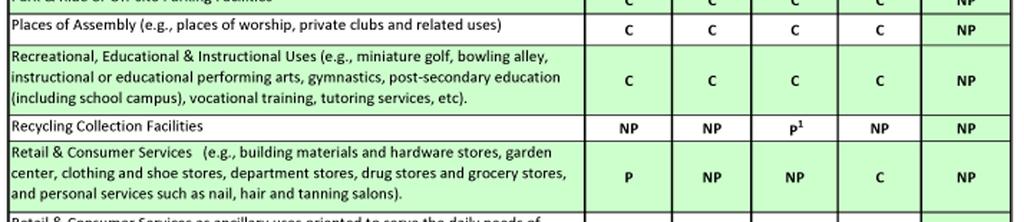
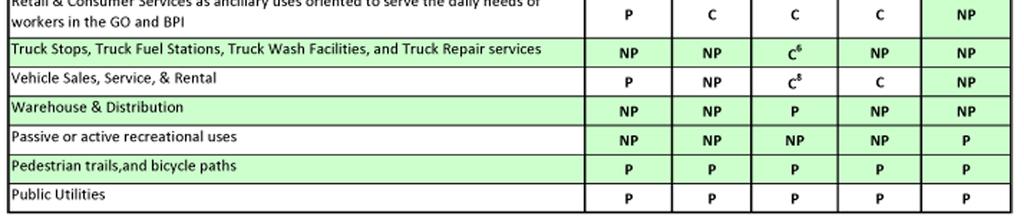
4 C O R D E S R A N C H S P E C F I C P L A N Table 3.1, Permitted and Conditionally Permitted Uses 3-4

5 SEPTEMBER 3, 2013 CORDES RANCH SPEC IF IC PLAN: T RACY, CAL IFORN IA Parks (P) The Parks Zone is designed to provide for open space areas and park facilities which offer recreational, cultural, entertainment, community gardens, and similar uses. In addition, the Parks Zone allows for the construction of certain types of flood control infrastructure to implement the citywide Storm Drainage Master Plan. I-205 Overlay The I-205 Overlay applies to property within 500 feet of I-205 to take advantage of the high visibility of properties adjacent to I-205. This area includes a refined range of uses from the BPI Zone to promote high visibility development opportunities that allow a blend of office with light assembly, manufacturing, and business industrial flex uses. The Overlay requires higher development standards with emphasis on building orientation, architectural design, and landscape planting and screening. Nonconforming agricultural uses existing and operating at the date of Cordes Ranch Specific Plan adoption within the Project Area shall be broadly interpreted to allow continued agricultural operations until development in conformance with this Specific Plan occurs. Agricultural crops or operations may change to another, such as row crops to orchards, without the property losing its nonconforming status. Table 3.2 presents the prohibited uses which will not be allowed to develop within any zoning district within the Cordes Ranch Specific Plan. Table 3.1 Notes: 1. All of these uses must be conducted wholly within a building, including storage. 2. These outdoor storage uses must be completely screened from view from I-205 and public streets. 3. Includes accessory space for showrooms/sales. 4. Permitted only in buildings 75,000 square feet or smaller. 5. These uses shall be allowed to include interior warehousing and interior storage as an accessory use. 6. Truck stops are not permitted north of Capital Parks Drive or west of Mountain House Parkway. 7. Entertainment means such uses as live music, disc jockeys, dancing, karaoke, comedy shows, modeling, or live performances. 8. Only in I-205 Overlay with a Conditional Use Permit. 3.3 PERMITTED AND CONDITIONALLY PERMITTED USES Table 3.1 presents the permitted and conditionally permitted land uses within the Project Area. In addition, accessory uses and temporary uses shall be allowed as provided in the Tracy Municipal Code, including temporary construction activities and on-site construction staging areas with concrete and/or asphalt batch facilities. Table 3.2, Prohibited Uses 3-5


6 C O R D E S R A N C H S P E C F I C P L A N 3.4 DEVELOPMENT STANDARDS Development standards have been prepared for each of the zoning districts outlined in Section 3.2. Table 3.3 presents the standards for development which include minimum setback requirements, maximum building heights, and landscape setbacks. No lot shall be created with size or dimensions rendering it incapable of meeting the land use, public utilities, or development standards of this Specific Plan. Modifications in these standards may be necessary to respond to unique site characteristics and/or changes in development requirements to respond to market conditions. Modifications to these standards will require Planning Commission and City Council review through a Specific Plan amendment per the City of Tracy Municipal Code requirements. Unless otherwise established herein, all definitions and land use terms shall be as stated in the Tracy Municipal Code. Table 3.3, Development Standards 3-6


7 SEPTEMBER 3, 2013 CORDES RANCH SPEC IF IC PLAN: T RACY, CAL IFORN IA 3.5 OFF-STREET PARKING The Tracy Municipal Code off-street parking requirements shall apply to the Cordes Ranch Specific Plan except as modified herein. On-street diagonal parking on Street Section J, along the parcel frontage of Streets B, E, and F may be counted as part of the offstreet parking requirement for adjacent development. Table 3.4, Required Off-site Parking 3-7

8 C O R D E S R A N C H S P E C F I C P L A N 3.6 LANDSCAPE STANDARDS FOR OFF-STREET PARKING AREAS Off-street parking areas will require landscaping per the standards established by the Tracy Municipal Code. Parking area landscaping shall be provided in accordance with Tracy Municipal Code standards unless otherwise provided herein. Table 3.5, Landscape Requirements for Parking Areas 3-8
9 SEPTEMBER 3, 2013 CORDES RANCH SPEC IF IC PLAN: T RACY, CAL IFORN IA 3.7 ADDITIONAL LANDSCAPING STANDARDS Parking Area Landscape When located adjacent to the freeway or other right-of-way frontage, parking should be screened by use of landscaping, berming, low decorative walls or combination of these. To the extent feasible, parking lot planting islands and tree placement should be coordinated with freeway edge planting and views into signage and any special architectural detailing. Parking lot trees should be provided at a minimum of one tree per 5 spaces. Large scale, high branching shade trees should be used in all parking areas. Vegetated bioswales are encouraged in parking lot planting islands to treat on-site stormwater. Pedestrian circulation should be carefully coordinated with bioswales. Landscaping shall be integrated with the building frontage. There shall be a minimum 10 foot wide (inside dimension) landscaped strip along property lines adjacent to the public rights-of-way and private streets. The landscaped strip shall be continuous except at required access to the site or parking area. Vegetated bioswales in planting islands 3-9
10 CORDES RANCH S P E C F I C P L A N Figure 3.3, Freeway Sign Design CHAPTER 3 LAND USE, ZONING, AND DEVELOPMENT STANDARDS 3-10
11 SEPTEMBER 3, 2013 CORDES RANCH SPEC IF IC PLAN: T RACY, CAL IFORN IA 3.8 SIGN STANDARDS Signs within the Project Area shall be allowed in accordance with Tracy Municipal Code standards, except as modified herein. Freeway Sign A total of two Freeway Signs visible from both eastbound and westbound directions of I-205 are allowed within the Cordes Ranch Specific Plan. They may be located within the General Commercial parcels adjacent to I-205, and may provide advertising of businesses located within the General Commercial Zone. Figure 3.3 depicts the design and dimensions for the Freeway Sign, and Figure 3.4 depicts the approximate location for each. Freeway Sign Design Standards 1. Maximum height: Maximum width: Maximum area: 300 square feet per sign face 4. Minimum ground clearance: 8 5. Maximum number of signs permitted: 2 within the Cordes Ranch Specific Plan Area. Figure 3.4, Freeway Sign Locations 3-11
NOTICE OF SPECIAL MEETING
 NOTICE OF SPECIAL MEETING Pursuant to Section 54956 of the Government Code of the State of California, a Special meeting of the Tracy City Council is hereby called for: Date/Time: Location: Tuesday, April
CHAPTER 21 NC-PUD NEIGHBORHOOD COMMERCIAL PUD DISTRICT
 CHAPTER 21 NC-PUD NEIGHBORHOOD COMMERCIAL PUD DISTRICT Section 21.1. Title and Purpose. The Neighborhood Commercial Planned Unit Development District, designated the, is intended for commercial uses of
MIXED-USE VILLAGE OVERLAY FLOATING DISTRICT
 MIXED-USE VILLAGE OVERLAY FLOATING DISTRICT Zoning regulations developed by committee to the Planning Board for the Town of DeWitt, NY Issue date: 13 July 2017 revised 3/12/2018, revised 4/26/2018, 5/9/2018
PLANNED UNIT DEVELOPMENT STAFF REPORT Date: June 2, 2016
 # 9 ZON2016-01032 PLANNED UNIT DEVELOPMENT STAFF REPORT Date: June 2, 2016 DEVELOPMENT NAME JJT Properties LLC LOCATION 1147 & 1151 East I-65 Service Road South and 1180 Sledge Drive (Southeast corner
OFFICE CONSOLIDATION SECONDARY PLAN AREA 22 THE BRAMALEA SOUTH INDUSTRIAL SECONDARY PLAN
 OFFICE CONSOLIDATION SECONDARY PLAN AREA 22 THE BRAMALEA SOUTH INDUSTRIAL SECONDARY PLAN November 2010 EXPLANATORY NOTES (Secondary Plan Area 22) General (pertaining to all secondary plan office consolidations)
City Of Sparks Planning Commission Item
 Page 1 of 12 City Of Sparks Planning Commission Item Meeting Date: May17, 2012 Subject: PCN12009, Public Hearing, Consideration and possible action on a Master Plan Amendment and Rezoning request to change
The transportation system in a community is an
 7 TRANSPORTATION The transportation system in a community is an important factor contributing to the quality of life of the residents. Without a sound transportation system to bring both goods and patrons
ARTICLE 6: Special and Planned Development Districts
 ARTICLE 6: Special and Planned Development Districts 6-10 Traditional Neighborhood Development (TND) District 6-10.10 Purpose and Intent The Traditional Neighborhood Development (TND) District provides
CHAPTER FIVE COMMUNITY DESIGN
 CHAPTER FIVE COMMUNITY DESIGN CHAPTER FIVE - COMMUNITY DESIGN Assumptions Frazier Park and Lebec have historically developed according to different patterns of spatial form. While both communities are
CITY OF PUYALLUP. Background. Development Services
 CITY OF PUYALLUP Development Services 333 South Meridian Puyallup WA 98371 To: City Council From: Katie Baker, AICP, Planning Division Re: South Hill Neighborhood Plan Adoption Date: (Meeting date: February
Exhibit A. 8:9 Scuffletown Rural Conservation District
 Exhibit A 8:9 Scuffletown Rural Conservation District 8:9.1 Intent and Purpose The Scuffletown Rural Conservation (SRC) District is intended to provide for residential development that supports the development
City of Redlands East Valley Corridor Specific Plan. City Council
 City of Redlands East Valley Corridor Specific Plan City Council Susan Peppler, Mayor Gilbert Gil, Mayor Pro Tem Gary George, Councilmember Patricia Gilbreath, Councilmember Jon Harrison, Councilmember
Landscaping Standards
 CHAPTER 29 ARTICLE 403 29.403 Landscaping Standards Purpose: The purpose of this section is to protect and promote the public health, safety and general welfare by requiring landscaping in relation to
3.0 LAND USE PLAN. 3.1 Regional Location. 3.2 Existing Conditions Existing Uses. Exhibit Regional Location Map
 3.0 LAND USE PLAN 3.1 Regional Location The Anaheim Resort Specific Plan (ARSP) area is located in the City of Anaheim, which is 35 miles southeast of downtown Los Angeles and 7 miles northwest of Santa
PORT WHITBY COMMUNITY
 PORT WHITBY COMMUNITY SECONDARY PLAN UPDATE COMMUNITY IMPROVEMENT PLAN URBAN DESIGN GUIDELINES September 2015 DRAFT PROPOSED AMENDMENT NUMBER # to the Whitby Official Plan PURPOSE: The intent of this Amendment
City Center Specific Plan Amendments And Background Report City of Richmond. PLANNING COMMISION FINAL DRAFT January, 2001
 City Center Specific Plan Amendments And Background Report City of Richmond PLANNING COMMISION FINAL DRAFT January, 2001 TABLE OF CONTENTS Page LIST OF TABLES... LIST OF FIGURES... INDEX... OVERVIEW...
CHAPTER 1. Ms. Guajardo s Class - Central Elementary CH 1 1
 INTRODUCTION CHAPTER 1 Ms. Guajardo s Class - Central Elementary CH 1 1 1.1 SETTING South Centre City is a linear corridor south of Downtown Escondido paralleling Centre City Parkway and South Escondido
Scope of Services. River Oaks Boulevard (SH 183) Corridor Master Plan
 Corridor Master Plan") Scope of Services River Oaks Boulevard (SH 183) Corridor Master Plan PROJECT AREA The project area consists of the River Oaks Boulevard (SH 183) corridor bounded by SH 199 at the northern end and the Trinity
Scope of Services River Oaks Boulevard (SH 183) Corridor Master Plan PROJECT AREA The project area consists of the River Oaks Boulevard (SH 183) corridor bounded by SH 199 at the northern end and the Trinity
4. INDUSTRIAL 53 CASTLE ROCK DESIGN
 4. INDUSTRIAL 53 CASTLE ROCK DESIGN CASTLE ROCK DESIGN 54 4. INDUSTRIAL Overview Well-designed and attractive industrial centers are the product of blending economic realities with both functional and
3. Project Description
 3.1 PROJECT LOCATION The Platinum Triangle (herein after also referred to as the Project Area ) is located at the confluence of the Interstate 5 (I-5 Freeway) and the State Route 57 (SR-57 Freeway), in
SECTION UNIFIED DEVELOPMENT ORDINANCE SECTION Part 1 Ordinance. ARTICLE 1 Zoning Districts
 SECTION 1-100 UNIFIED DEVELOPMENT ORDINANCE SECTION 1-300 Part 1 Ordinance SECTION 1-100. Introduction. ARTICLE 1 Zoning Districts Crystal Lake strives to maintain a balance of various land uses for a
CITY OF SAN MATEO ORDINANCE NO
 CITY OF SAN MATEO ORDINANCE NO. 2012-4 AMENDING SECTION 27.38.090, OPEN SPACE REQUIREMENTS, OF CHAPTER 27.38, CBD DISTRICTS-CENTRAL BUSINESS DISTRICT, SECTION 27.64.023, PARKING PROHIBITED ON LAWNS, FLOWERS,
City of Astoria Development Code ARTICLE 2 USE ZONES R-1: LOW DENSITY RESIDENTIAL ZONE
 ARTICLE 2 R-1 Zone USE ZONES R-1: LOW DENSITY RESIDENTIAL ZONE 2.015. PURPOSE. The purpose of the R-1 Zone is to provide an area of low density single-family dwellings, at an average density of eight (8)
New Berlin City Center Concept Review PDQ Food Stores, Inc
 September 23, 2016 City of New Berlin Planning Commission 3805 S Casper Dr New Berlin, WI 53151 RE: New Berlin City Center Concept Review PDQ Food Stores, Inc Dear Plan Commission Members, On behalf of
LANDSCAPE ORDINANCE PASADENA PLANNING DEPARTMENT (713) FAX (713)
 FAX (713)") LANDSCAPE ORDINANCE PASADENA PLANNING DEPARTMENT (713) 475-5543 FAX (713) 477-1072 ARTICLE X. LANDSCAPING OF NONRESIDENTIAL SITES* Sec. 9-195. Applicability. (a) This article shall apply to the following:
LANDSCAPE ORDINANCE PASADENA PLANNING DEPARTMENT (713) 475-5543 FAX (713) 477-1072 ARTICLE X. LANDSCAPING OF NONRESIDENTIAL SITES* Sec. 9-195. Applicability. (a) This article shall apply to the following:
PRINCE EDWARD COUNTY HIGHWAY CORRIDOR OVERLAY DISTRICT DESIGN GUIDE
 PRINCE EDWARD COUNTY HIGHWAY CORRIDOR OVERLAY DISTRICT DESIGN GUIDE AUGUST 21, 2012 Table of Contents Introduction 3 Sample Architecture 4 Design Standards Access and Circulation 6 Buildings 7 Landscaping
STORMWATER MANAGEMENT CODES ANALYSIS RICHLAND COUNTY, SC SITE PLANNING ROUNDTABLE
 STORMWATER MANAGEMENT CODES ANALYSIS RICHLAND COUNTY, SC SITE PLANNING ROUNDTABLE Codes analyses for each subcommittee were completed to assist participants of the Richland County Site Planning Roundtable.
PLANNING COMMISSION AGENDA REPORT NOVEMBER 15, 2012
 PLANNING COMMISSION AGENDA REPORT NOVEMBER 15, 2012 TO: FROM: Members of the Planning Commission Michael Klein, Associate Planner FILE NO.: 120000890 PROPOSAL: APPLICANT: Request for an Administrative
Chapter 1: General Program Information
 Chapter 1: General Program Information 1.1 Introduction The Montgomery County Stormwater Management Resolution (#03-1-5) was adopted by the County Board of Commissioners on January 22, 2003. The purpose
ZONING AMENDMENT, PLANNED UNIT DEVELOPMENT & SUBDIVISION STAFF REPORT Date: March 20, 2008
 ZONING AMENDMENT, PLANNED UNIT DEVELOPMENT & SUBDIVISION STAFF REPORT Date: March 20, 2008 NAME SUBDIVISION NAME LOCATION Joseph Mramor Mramor s Addition to Weinacker Avenue Subdivision 900 Weinacker Avenue
9IMPLEMENTATION AND PHASING
 9IMPLEMENTATION AND PHASING Purpose A key objective of the Railyard Master Plan is the integration of the public and private realm to provide a network of places that connect to and complement Commercial
Preserve the Flower and Strawberry Fields and Save Carlsbad Taxpayers* Money
 EXHIBIT "A" Preserve the Flower and Strawberry Fields and Save Carlsbad Taxpayers* Money The People of the City of Carlsbad do hereby enact and ordain: 1. Section 1. TITLE 1.1 This measure shall be known
Zoning Technical Review Presented by Camiros. November 10, 2015
 Zoning Technical Review Presented by Camiros November 10, 2015 TECHNICAL REVIEW OVERVIEW Purpose of this Report Outline issues with current Ordinance Present preliminary approaches for revisions Set drafting
FORMER CANADIAN FORCES BASE (CFB) ROCKCLIFFE SECONDARY PLAN. Official Plan Amendment XX to the Official Plan for the City of Ottawa
 ROCKCLIFFE SECONDARY PLAN. Official Plan Amendment XX to the Official Plan for the City of Ottawa") FORMER CANADIAN FORCES BASE (CFB) ROCKCLIFFE SECONDARY PLAN Official Plan Amendment XX to the Official Plan for the City of Ottawa 1 INDEX THE STATEMENT OF COMPONENTS PART A THE PREAMBLE PAGE Purpose...
FORMER CANADIAN FORCES BASE (CFB) ROCKCLIFFE SECONDARY PLAN Official Plan Amendment XX to the Official Plan for the City of Ottawa 1 INDEX THE STATEMENT OF COMPONENTS PART A THE PREAMBLE PAGE Purpose...
8implementation. strategies
 PROGRAM STRATEGIES 8implementation strategies T he implementation actions of this chapter are designed to support and carry out the land use, economic development, transportation, urban design, and program
3. Additional driveways may be permitted where determined by the Planning Commission to adequately accommodate traffic or ensure public safety.
 ARTICLE 10 ACCESS MANAGEMENT Section 10.01 Purpose. The purpose of this Article is to protect the substantial public investment in the City s street system by preserving the traffic capacity of existing
ORDINANCE WHEREAS, this Ordinance is consistent with the City of Winter Garden Comprehensive Plan; and
 ORDINANCE 17-06 AN ORDINANCE OF THE CITY COMMISSION OF THE CITY OF WINTER GARDEN, FLORIDA, CREATING ARTICLE XIV OF CHAPTER 118 OF THE CITY OF WINTER GARDEN CODE OF ORDINANCES PROVIDING FOR THE EAST PLANT
and services The protection and conservation of environmentally significant and sensitive natural heritage features and functions.
 6. Land Use 6.0 Preamble A healthy and livable city is one in which people can enjoy a vibrant economy and a sustainable healthy environment in safe, caring and diverse neighbourhoods. In order to ensure
3.10 ROW Overlay District
 3.10 A. Purpose The purpose of this Overlay District is to regulate items which could be placed or constructed within the Rights-of-way lying wholly or partially within the jurisdictional area of the Town
EXHIBIT A. Chapter 2.7 SPECIAL PLANNED DISTRICTS. Article XVIII 15th Street School Master Planned Development
 EXHIBIT A Chapter 2.7 SPECIAL PLANNED DISTRICTS Article XVIII 15th Street School Master Planned Development Sections: 2.7.3600 15 th Street School Master Planned Development 2.7.3610 Purpose 2.7.3620 Definitions
The Town Board of the Town of Vienna, County of Dane, State of Wisconsin, does ordain and adopt as follows.
 ORDINANCE DRIVEWAYS AND CULVERTS NO. 6-5-06 ORDINANCE CONCERNING DRIVEWAY AND CULVERT REQUIREMENTS 1-1-1 Driveway Permits; Culvert Requirements 1-1-2 Driveway and Culvert Location, Design and Construction
PLANNING COMMISSION STAFF REPORT
 PLANNING COMMISSION STAFF REPORT AMENDMENTS TO CHAPTER 21A.46.120 Proposal to Create a Localized Alternative Sign Overlay for Library Square Case # 25 April 2012 Planning and Zoning Division Department
NOW, THEREFORE, THE CITY COUNCIL OF THE CITY OF SIMI VALLEY DOES ORDAIN AS FOLLOWS:
 ORDINANCE NO. 1241 AN ORDINANCE OF THE CITY COUNCIL OF THE CITY OF SIMI VALLEY APPROVING A SIMI VALLEY MUNICIPAL CODE TEXT AMENDMENT (Z-S-721) TO ALLOW THE USE OF ARTIFICIAL TURF IN MULTI-FAMILY RESIDENTIAL
ARTICLE 12. LANDSCAPING REQUIREMENTS.
 ARTICLE 12. LANDSCAPING REQUIREMENTS. 12.1 GENERAL REQUIREMENTS 12.2 LANDSCAPE PLAN REQUIRED 12.3 LANDSCAPE DESIGN STANDARDS 12.4 REQUIRED PARKING LOT LANDSCAPE 12.5 REQUIRED BUFFER YARD 12.6 ADDITIONAL
City of San Ramon. Zoning Ordinance. Adopted: October 27, Latest Revisions Effective: March 28, 2018
 City of San Ramon Zoning Ordinance Adopted: October 27, 2015 Latest Revisions Effective: March 28, 2018 City of San Ramon 7000 Bollinger Canyon Road San Ramon, California 94583 [Page intentionally left
Staff Report Bourbon County Joint Planning Office SPECIAL MEETING September 4, 2018
 Staff Report Bourbon County Joint Planning Office SPECIAL MEETING September 4, 2018 Case Number: DVP 18-05 FINAL Applicant: Josh Cummins Location: Arlington Drive. Request: Car Dealer Parking Lot Zoning:
CARVER COUNTY DIVISION OF PUBLIC WORKS LANDSCAPE POLICY. Adopted by the Carver County Board of Commissioners March 3, 2015
 CARVER COUNTY DIVISION OF PUBLIC WORKS LANDSCAPE POLICY Adopted by the Carver County Board of Commissioners March 3, 2015 Policy Statement Goals It is the goal of Carver County Public Works to provide
PLANNING COMMISSION STAFF REPORT Legislative Item
 PLANNING COMMISSION STAFF REPORT Legislative Item Manufacturing Districts Monument Sign Height Zoning Text Amendment PLNPCM2013-00197 Citywide August 28, 2013 Planning Division Department of Community
ARLINGTON COUNTY, VIRGINIA
 ARLINGTON COUNTY, VIRGINIA County Board Agenda Item Meeting of March 20, 2007 SUPPLEMENTAL REPORT #2 Additional and Revised Information DATE: March 20, 2007 SUBJECT: Request to Advertise Public Hearings
COUNTY COURT HOUSE REDEVELOPMENT AREA PLAN
 COUNTY COURT HOUSE REDEVELOPMENT AREA PLAN March 2005 CITY OF TRENTON DEPARTMENT OF HOUSING AND ECONOMIC DEVELOPMENT TABLE OF CONTENTS A. DESCRIPTION...3 1. BOUNDARIES OF PROJECT...3 2. REDEVELOPMENT PLAN
Chapter PEDESTRIAN COMMERCIAL (PC) ZONING DISTRICT
 ZONING DISTRICT") Chapter 11-17 PEDESTRIAN COMMERCIAL (PC) ZONING DISTRICT Sections: 11-17-01 GENERAL PURPOSE 11-17-02 PERMITTED BUILDING TYPES 11-17-03 USES PERMITTED WITH DESIGN REVIEW 11-17-04 USES PERMITTED BY CONDITIONAL
Chapter 11-17 PEDESTRIAN COMMERCIAL (PC) ZONING DISTRICT Sections: 11-17-01 GENERAL PURPOSE 11-17-02 PERMITTED BUILDING TYPES 11-17-03 USES PERMITTED WITH DESIGN REVIEW 11-17-04 USES PERMITTED BY CONDITIONAL
Table L-1 Summary Action Strategy. Action Item Timing Status Responsible Agency
 CHAPTER 4: CIRCULATION ELEMENT ISSUE #1: MAJOR THOROUFARES AND TRANSPORTATION ROUTES A balanced transportation system for Fontana is provided that meets the mobility needs of current and future residents
APPENDIX J PERFORMANCE STANDARDS FOR GRAVEL MINE, PIT MINE, OR QUARRY
 APPENDIX J PERFORMANCE STANDARDS FOR GRAVEL MINE, PIT MINE, OR QUARRY A. Purpose: 1. Regulatory Requirement and Use Mitigation: The purpose of this appendix is to provide a regulatory context (standards)
4.500 Preston Road Overlay District
 Section 4.500 Preston Road Overlay District 2004 Zoning Ordinance 4.500 Preston Road Overlay District (ZC 98-29; Ordinance No. 98-9-12) 4.501 Purpose To provide appropriate design standards for the use
BRAMPTON FLOWERTOWN SECONDARY PLAN Area 6
 BRAMPTON FLOWERTOWN SECONDARY PLAN Area 6 October 2018 EXPLANATORY NOTES Brampton Flowertown Secondary Plan Area 6 General i. Secondary plans form part of the Official Plan and are to be read in conjunction
PROP. 84 REMOVING BARRIERS TO LID: MUNICIPAL CODE UPDATE ASSISTANCE CASE STUDY: CODE UPDATES IN ARCATA
 PROP. 84 REMOVING BARRIERS TO LID: MUNICIPAL CODE UPDATE ASSISTANCE CASE STUDY: CODE UPDATES IN ARCATA OCTOBER 7, 2015 CASE STUDY: CODE UPDATES IN ARCATA Arcata is a city located in Humboldt County immediately
The Highway Overlay District applies to an area within the City of Papillion's zoning jurisdiction described as:
 ARTICLE XXVIII. HOD Highway Overlay District 205-164. Intent. The Highway Overlay District recognizes the strategic importance of the Highway 370 corridor as an entrance to Papillion from Interstate 80
CAMPUS PLANNING COMMITTEE STAFF REPORT SAMARITAN SPORTS MEDICINE INSTITUTE AT OSU 10/21/2013
 Office of Capital Planning and Development; 130 Oak Creek Building; Corvallis, Oregon 97331-2001 CPC STAFF REPORT: SAMARITAN SPORTS MEDICINE INSTITUTE AT OSU CAMPUS PLANNING COMMITTEE STAFF REPORT SAMARITAN
APPLICATION BRIEFING Prepared For: Submitted by: Date: Subject:
 Planning & Development APPLICATION BRIEFING Prepared For: Submitted by: Date: Subject: Planning Advisory Committee Jason Fox, Director of Planning & Development Development Agreement application by Godfrey
Venice Pumping Plant Dual Force Main Project Draft EIR
 City of Los Angeles 5.9 LAND USE PLANS 5.9.1 Environmental Setting Venice Pumping Plant Dual Force Main Project Draft EIR The Project lies within the bounds of Los Angeles County and the City of Los Angeles.
Red Fox Commercial Outline Plan
 Red Fox Commercial Outline Plan City of Cold Lake, Alberta Prepared by Durrance Projects Ltd and Ross W. Sharp & Associates Ltd October 2014 Rupert 1 Table of Contents 1. PURPOSE...3 1.1. Location...4
AIRPORT BUSINESS AREA POLICY PLAN
 CITY OF VACAVILLE AIRPORT BUSINESS AREA POLICY PLAN CITY OF VACAVILLE COMMUNITY DEVELOPMENT DEPARTMENT 650 MERCHANT STREET VACAVILLE, CA 95688 (707) 449-5140 Adopted: AIRPORT BUSINESS AREA POLICY PLAN
Division 9 Southwood Ranch (CR 484/475/475A Corridor-Gateway Development Overlay) Purpose and Intent Applicability.
 Purpose and Intent Applicability.") Division 9 Southwood Ranch (CR 484/475/475A Corridor-Gateway Development Overlay) 5.9.1 Purpose and Intent. The Southwood Ranch Overlay is intended to be a mixed use community with commercial and residential
Division 9 Southwood Ranch (CR 484/475/475A Corridor-Gateway Development Overlay) 5.9.1 Purpose and Intent. The Southwood Ranch Overlay is intended to be a mixed use community with commercial and residential
CHAPTER SPECIAL PURPOSE AND OVERLAY ZONING DISTRICTS
 Special Purpose and Overlay Zoning Districts 106.28.010 CHAPTER 106.28 - SPECIAL PURPOSE AND OVERLAY ZONING DISTRICTS SPECIAL PURPOSE AND OVERLAY ZONING DISTRICTS Sections: 106.28.010 - Purpose 106.28.020
Table 34-1 (amended )
") Section 34.00 Preamble The purpose of the Brown Road Innovation Zoning District shall be to encourage the development of property in accordance with the Charter Township of Orion Master Plan in a manner
Section 34.00 Preamble The purpose of the Brown Road Innovation Zoning District shall be to encourage the development of property in accordance with the Charter Township of Orion Master Plan in a manner
VEHICULAR AND PEDESTRIAN CIRCULATION
 This perspective sketch communicates the intended character and quality of a proposed streetscape design. Locate benches near a major intersection where people tend to gather. Seating and lighting provide
CHAPTER 2: FUTURE LAND USE CONCEPTS
 CHAPTER 2: FUTURE LAND USE CONCEPTS INTRODUCTION The future land use concepts presented in this chapter are an expression of community support for a viable and vital US 50 Corridor. Land use recommendations
The Brown Road Innovation Zoning District shall be specified for the areas as designated on the Charter Township of Orion Zoning Map.
 Section 34.00 Preamble The purpose of the Brown Road Innovation Zoning District shall be to encourage the development of property in accordance with the Charter Township of Orion Master Plan in a manner
WILLOW KILKENNY POLICY PLAN
 CITY OF VACAVILLE WILLOW KILKENNY POLICY PLAN CITY OF VACAVILLE COMMUNITY DEVELOPMENT DEPARTMENT 650 MERCHANT STREET VACAVILLE, CA 95688 (707) 449-5140 WILLOW-KILKENY POLICY PLAN Adopted: June 23, 1998
ZONING AMENDMENT & PLANNED UNIT DEVELOPMENT STAFF REPORT Date: April 4, 2013
 ZONING AMENDMENT & PLANNED UNIT DEVELOPMENT STAFF REPORT Date: April 4, 2013 NAME DEVELOPMENT NAME LOCATION DIP Exchange, LLC DIP Exchange, LLC 93 Sidney Phillips Drive (West side of Sidney Phillips Drive,
Rezoning Petition Zoning Committee Recommendation August 1, 2017
 Rezoning Petition 2017-090 Zoning Committee Recommendation August 1, 2017 REQUEST LOCATION SUMMARY OF PETITION PROPERTY OWNER PETITIONER AGENT/REPRESENTATIVE COMMUNITY MEETING STATEMENT OF CONSISTENCY
North Oakville East Parks Facilities Distribution Plan. November, 2009
 North Oakville East November, 2009 POLICY CONTEXT 1) Purpose a) The purpose of this document is to be a guide for the location, configuration, design and development of the parks system for the North Oakville
Improve the appearance of off-street parking areas, vehicular use areas, and property abutting public and private roads;
 Bedford Township, MI (Monroe Co.) 2012 http://library.municode.com/index.aspx?clientid=02123 400.1907 - Landscaping and screening. Se 1907. 1. Intent. Landscaping, greenbelts, and screening are necessary
17.11 Establishment of Land Use Districts
 17.11 Establishment of Land Use Districts 17.11.010 Purpose. To promote the health, safety, and general welfare of City residents and those who come to South Salt Lake to work, exchange commerce and recreate.
Chapter 7: Land Use Plan
 Chapter 7: Land Use Plan The intended purpose of the Land Use Plan is to guide the future physical development of Wall Township by designating proposed land use categories including proper location and
6.0 Land Use Policies for Rural Settlements. 6.1 Rural Settlement Strategy
 6.0 Land Use Policies for Rural Settlements 6.1 Rural Settlement Strategy INTRODUCTION AMENDMENT NO. 131 PURPOSE Designated rural settlements comprise Rural Clusters, Villages and Serviced Villages as
Best Practices Appendix: Waterfront Communities
 Redevelopment Ready Communities Best Practices Appendix: Waterfront Communities revised September 2014 Waterfront RRC defined The purpose of these additional criteria is to provide waterfront communities
OUR JOBS Innisfil Heights Strategic Settlement Employment Area Planning Policy Update. Council Workshop April 22, 2015
 Innisfil Heights Strategic Settlement Employment Area Planning Policy Update Council Workshop April 22, 2015 Study Objectives Support the Economy pillar of Inspiring Innisfil 2020 Strategically position
URBAN DESIGN BRIEF 305, 309, & 315 SOUTHDALE ROAD WEST LONDON ONTARIO
 URBAN DESIGN BRIEF 305, 309, & 315 SOUTHDALE ROAD WEST LONDON ONTARIO CARVEST PROPERTIES LTD. December 2013 Section 1 - Land Use Planning Context 1.1 Subject Lands The subject lands are located immediately
Olde Towne Vision Plan
 Olde Towne Vision Plan Introduction In 2016, the City of Bellevue will complete its move of City offices from Olde Towne Bellevue to its new municipal complex on Wall Street. The City intends to sell its
Location and Field Inspection: History: Master Plan Recommendation:
 R E S O L U T I O N WHEREAS, the Prince George s County Planning Board has reviewed Special Permit Application No. SP-130008, Sudsville Laundry, requesting a special permit to construct an addition and
Commercial Development Standards. City of Homestead
 Commercial Development Standards City of Homestead Presentation Outline Introductions Purpose and Intent Objectives Administrative Process Established Districts Design Standards Purpose and Intent Supplement
14 October 10, 2012 Public Hearing APPLICANT: MPB, INC
 14 October 10, 2012 Public Hearing APPLICANT: MPB, INC PROPERTY OWNER: MUNDEN & ASSOCIATES, LP STAFF PLANNER: Karen Prochilo REQUEST: Conditional Change of Zoning (AG-1 & AG-2 to Conditional O-2) ADDRESS
CHAPTER ADDITIONAL REQUIREMENTS IN THE NC, NEIGHBORHOOD COMMERCIAL ZONE
 CITY OF MOSES LAKE MUNICIPAL CODE CHAPTER 18.31 ADDITIONAL REQUIREMENTS IN THE NC, NEIGHBORHOOD COMMERCIAL ZONE Sections: 18.31.010 Purpose 18.31.020 Minimum Lot Area 18.31.030 Setbacks 18.31.040 Maximum
SUBDIVISION, PLANNED UNIT DEVELOPMENT, PLANNING APPROVAL, REZONING & SIDEWALK WAIVER STAFF REPORT Date: February 7, 2013
 SUBDIVISION, PLANNED UNIT DEVELOPMENT, PLANNING APPROVAL, REZONING & SIDEWALK WAIVER STAFF REPORT Date: February 7, 2013 APPLICANT NAME SUBDIVISION NAME DEVELOPMENT NAME LOCATION S. E. Cemeteries of AL
Urban Planning and Land Use
 Urban Planning and Land Use 701 North 7 th Street, Room 423 Phone: (913) 573-5750 Kansas City, Kansas 66101 Fax: (913) 573-5796 Email: planninginfo@wycokck.org www.wycokck.org/planning To: From: City Planning
Planning Commission Staff Report February 19, 2009
 Planning Commission Staff Report February 19, 2009 Project: Warda Warehouse File: EG-08-051 Request: Design Review Location: 9260 Bendel Place APNs: 134-0660-004 Planner: Gerald Park Property Owner/Applicant
City Council Special Meeting. August 9, 2017
 DREAMPORT VILLAGES CASA GRANDE City Council Special Meeting August 9, 2017 Regional Gateway Commerce Center PAD Casa Grande Mountain Ranch PAD ARICA RD. OVERVIEW Dreamport Villages North 618 acre commercial
AMENDMENT NO. 42 TO THE OFFICIAL PLAN OF THE TOWN OF GRIMSBY
 AMENDMENT NO. 42 TO THE OFFICIAL PLAN OF THE TOWN OF GRIMSBY INITIATED BY TOWN OF GRIMSBY TABLE OF CONTENTS PART I: THE CERTIFICATION Certification Page Adopting By-law of the Town of Grimsby PART II:
Approved: CITY OF ARDEN HILLS, MINNESOTA PLANNING COMMISSION WEDNESDAY, AUGUST 5, :30 P.M. - ARDEN HILLS CITY HALL
 Approved: CITY OF ARDEN HILLS, MINNESOTA PLANNING COMMISSION WEDNESDAY, AUGUST 5, 2015 6:30 P.M. - ARDEN HILLS CITY HALL PLANNING CASES A. Planning Case 15-016; Final Planned Unit Development Arden Plaza;
4. UTILITIES ELEMENT.
 4. UTILITIES ELEMENT. The purpose of this element is to provide for necessary public facilities and services correlated to future land use projections and population demand. Utilities Sub-Elements (A)
Request by Fareway Stores Inc. to Initiate Neighborhood Commercial Zoning Text Amendments
 ITEM: 26_ Staff Report Request by Fareway Stores Inc. to Initiate Neighborhood Commercial Zoning Text Amendments BACKGROUND: August 14, 2018 Fareway has an interest in redeveloping the site of their Downtown
5.1 Commercial and Industrial Development. (Effective April 1, 2006)
") 5.1 Commercial and Industrial Development. (Effective April 1, 2006) A. Applicability: The requirements of this section (5.10) shall apply to all uses within the LB Local Business; HB Highway Business;
5.1 Commercial and Industrial Development. (Effective April 1, 2006) A. Applicability: The requirements of this section (5.10) shall apply to all uses within the LB Local Business; HB Highway Business;
A. WHAT IS A GENERAL PLAN?
 I. Introduction A. WHAT IS A GENERAL PLAN? A general plan is the planning guideline for the future of a city. It contains goals and policies which regulate urban development, the protection of the natural
Town of Yucca Valley Capital Improvement Projects Report July 24, 2014
 Town of Yucca Valley Capital Improvement Projects Report July 24, 2014 SR 62 Traffic and Pedestrian Improvements from Apache Trail to Palm Avenue (PLHD) The project includes construction of curbs, gutters,
North Metro Natural Gas Pipeline Project Routing Study. Exhibit I: Comment and Response Document
 North Metro Natural Gas Pipeline Project Routing Study Exhibit I: Comment and Response Document North Metro Natural Gas Pipeline Project Routing Study This page intentionally left blank. North Metro Natural
City of Tacoma Planning and Development Services
 Agenda Item D-3 City of Tacoma Planning and Development Services To: Planning Commission From: Stephen Atkinson, Associate Planner, Planning Services Division Subject: Land Use Designations - Phase 2 Meeting
SUBCHAPTER 4-B GUIDELINES FOR THE B-3 COMMERCIAL CHARACTER AREA
 1 SUBCHAPTER 4-B GUIDELINES FOR THE B-3 COMMERCIAL CHARACTER AREA Downtown Bozeman should be the location of buildings of greatest height and intensity in the community. The following guidelines apply
KANATA CENTRUM 255 KANATA AVENUE OFFICIAL PLAN AMENDMENT ZONING BY-LAW AMENDMENT
 KANATA CENTRUM 255 KANATA AVENUE OFFICIAL PLAN AMENDMENT ZONING BY-LAW AMENDMENT JUNE 2015 PREPARED BY: FOTENN Consultants Inc. 223 Mcleod Street Ottawa, ON K2P OZ8 (613) 730-5709 PREPARED FOR: Kanata
Planning Board Report: Zoning Amendments (Articles 20 & 21)
") Planning Board Report: Zoning Amendments (Articles 20 & 21) Annual Town Meeting May 5, 2015 Planning Board Members: Jason Grimshaw, Chair Debra Friedman, Vice-Chair Adam Menard Sharon Nist David Wright
Planning Board Report: Zoning Amendments (Articles 20 & 21) Annual Town Meeting May 5, 2015 Planning Board Members: Jason Grimshaw, Chair Debra Friedman, Vice-Chair Adam Menard Sharon Nist David Wright