Anderson Memorial Bridge Rehabilitation Project Boston/Cambridge
|
|
|
- Erika Fox
- 6 years ago
- Views:
Transcription

1 Anderson Memorial Bridge Rehabilitation Project Boston/Cambridge MEPA Meeting, EEA#14702 Wednesday, March 2, :30 PM Dr. Martin Luther King, Jr. School 100 Putnam Avenue, Cambridge, MA Rendering by: Walt Baranowski Brown, Richardson & Rowe

2 Anderson Memorial Bridge Key Plan Anderson Memorial Bridge JFK Street Charles River Harvard Stadium North Harvard St. Weeks Pedestrian Bridge


3 Existing Bridge 100-year old three-span earth filled concrete arch 440 feet long Two 10-foot lanes each way 10-foot sidewalks on each side of the bridge Built in 1913 Context and Historic Significance of Bridge Listed on State and National Registers of Historic Places Integral component of historic Charles River Basin

4 Existing Condition


5 Cultural Resources Entire Area has Historic Significance Charles River Basin National Register Historic District Anderson Memorial Bridge Area buildings and structures JFK Memorial Park Rehabilitation must meet the Standards for the Treatment of Historic Properties This is is the site of the Great Bridge (opened in 1662) which was considered the first bridge of consequence built in America.
6 Bridge Alternatives Alternatives Considered: No Build New Concrete Arches New Superstructure over Rehabilitated Arches Rehabilitate Arches Preferred Alternative was Rehabilitation of Existing Arches Most Cost Effective Alternative Meets User Needs Protects Historic Resources
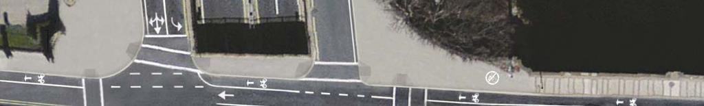
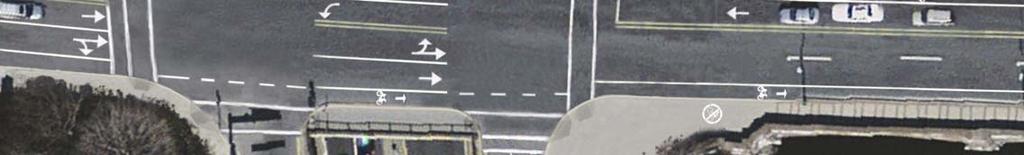
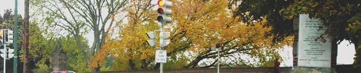
7 Traffic Layout Options Traffic Options Considered: Two lanes southbound on bridge and one lane northbound with: all turns allowed at JFK/Memorial Drive turn prohibitions at JFK/Memorial Drive Two lanes northbound on bridge and one lane southbound with: all turns allowed at JFK/Memorial Drive turn prohibitions at JFK/Memorial Drive Southbound left turn prohibited at JFK/Memorial Drive Closing Soldiers Field Road westbound on-ramp to Traffic (except emergency use); Note: All alternatives included 5 foot-wide bike lanes on bridge. Preferred Alternative: Two lanes northbound on bridge and one lane southbound. This alternative enhances safety, minimizes vehicular conflicts at intersections and provides cross section continuity along the North Harvard Street corridor.
8 Traffic Improvements 3 Traffic Lanes (2 northbound / 1 southbound) Addition of Bikes Lanes on bridge to match North Harvard Street Signal and Intersection Improvements Elimination of delta islands to improve pedestrian safety Prohibiting left turns at the JFK/Memorial Drive intersection will eliminate conflicts and improves safety at the intersection
9 Existing Cross Section Existing Conditions 60 Foot Bridge Width 40 Foot Roadway Width (4 lanes) 2 10 foot Wide Sidewalks (For Pedestrians and Bicyclists) Volumes 1655/1810 VPH (AM/PM) 145/222 BPH (AM/PM) 355/877 PPH (AM/PM)
10 Proposed Cross Section LOOKING NORTH Existing Conditions 60 Feet Bridge Width 40 Feet Roadway Width (4 lanes) 20 Feet for Pedestrians and Bicyclists Proposed 60 Feet Bridge Width 31.5 Feet for Vehicles (3 lanes) 28.5 Feet for Pedestrians and Bicyclists
11 Alternatives for Bike and Pedestrian Accommodations Feasibility Study Conducted by FST to evaluate Underpass Options Alternatives 1A, 1B, 3A, and 3B - concrete underpasses through the approach walls Reduces conflict between bicycles and pedestrians and vehicular traffic but has undesired effect of Adverse Effect to historical bridge and parkland (including loss of stairway in Alternatives 1A & B) Increased impacts to bank, BLSF, Riverfront Area, and potentially LUW Loss of parkland Anticipated increased cost and schedule delays
12 Underpass through Approach Wall (Boston Side)

13 Underpass through Approach Wall (Cambridge Side)
14
15 Alternatives for Bike and Pedestrian Accommodations Alternatives 2 and 4 - boardwalk options Reduces conflict between bicycles and pedestrians and vehicular traffic but has undesired effect of Adverse Effect to historic district Increased impacts to River and LUW Loss of navigable waterway and increased conflict for boaters Anticipated increased cost and schedule delays

16 Boardwalk through Arch
17 Boardwalk through Arch CROSS SECTION THRU EXTERIOR ARCH
18 Alternatives for Bike and Pedestrian Accommodations No Build Alternative would not address recognized conflicts between multiple users. MassDOT made the decision to expand the project scope to include the intersections and bicycle and pedestrian improvements Preferred Alternative offers at grade improvements. Accommodates multiple uses and improves the safety of bicycle and pedestrian users Avoids increased negative impacts to resources regulated under WPA, Chapter 91, ACOE, and USCG Avoids an Adverse Effect to historic bridge and district Is consistent with MassDOT s principals of Context Sensitive Design Has significantly less negative impacts to the adjacent parkland and the Charles River and associated resource areas

19 MEMORIAL DR Proposed Improvements Memorial Drive/JFK Street N JFK STREET CHARLES RIVER WELD BOAT HOUSE Prohibit left turns Both Memorial Drive left turns JFK Street southbound left turns North Harvard northbound lefts Modify bridge cross section to include bike lanes, 1 southbound travel lane, and 2 northbound travel lanes Implement concurrent pedestrian phasing and LPI, rather than exclusive phasing used today Modify traffic signal timing and phasing and upgrade equipment

20 Proposed Improvements Soldiers Field Road/North Harvard Street NORTH HARVARD ST OFF-RAMP ON-RAMP ON-RAMP OFF-RAMP SOLDIERS FIELD RD N CHARLES RIVER Modify bridge cross section to include bike lanes, 1 southbound lane, and 2 northbound lanes Add turn lane from Soldiers Field Road eastbound off-ramp onto North Harvard St northbound Improve corner radius and eliminate raised Delta islands for enhanced pedestrian mobility Modify signal timing, phasing, and upgrade traffic signal to include leading pedestrian intervals
21 Proposed Improvements Soldiers Field Road/North Harvard Street


22 Proposed Improvements Soldiers Field Road/North Harvard Street


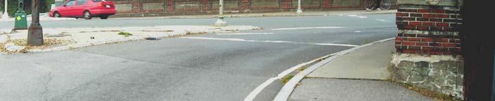


23 Improved Pedestrian Access Existing Proposed
24 Stormwater Improvements Existing roadway drainage directly discharges to the Charles River Opportunity to improve water quality and minimize impacts of stormwater runoff Address objectives of: MassDOT Impaired Waterbodies Program Lower the Charles River Total Maximum Daily Load (TMDL) Implementation Plan DEP Stormwater Management Standards
25 Stormwater Management (Best Management Practices/BMP s) JFK Street PART PLAN CAMBRIDGE SIDE WELD WELD BOATHOUSE BOATHOUSE Proposed Outlet and Stone Apron Deep Sump Catch Basins with hoods Deep Sump Manholes with hoods Subsurface Infiltration System Leaching structures Replace outfall New pipe, outlet treatment & stone apron

26 Landscape Restoration Landscape Benefits Restore park landscape after bridge rehabilitation in manner consistent with goals of DCR s Master Plan for the Charles River Basin.
27 Trees in Cambridge
28 Trees in Boston

29 Landscape Restoration N Plant new deciduous shade trees to replace trees that need to be removed in order to rehabilitate bridge. Protect trees to remain. Aerate soil. Plant new trees along path. Replace paths damaged during construction. Plant new trees to one side of bridge. Protect Plane Trees along Memorial Drive. Protect 3 Lindens near boathouse
30 MEPA ENF Thresholds Tree removal - more than 5 trees with a diameter at breast height of 14 inches or more State permits required and impacts to Riverfront Area that exceed 0.5 acres
31 Charles River Charles River Environmental Impacts PROJECT LIMIT OF WORK TEMP & PERM IMPACTS, TYP PLAN PROJECT LIMITS
32 LEGEND: PERM ALT. TEMP ALT. LUW TEMP ALT. BLSF Environmental Impacts TEMP ALT. 25 RFA Charles River Charles River PLAN ENVIRONMENTAL IMPACTS (BOSTON SIDE)
33 LEGEND: PERM ALT. Environmental Impacts TEMP ALT. LUW TEMP ALT. 25 RFA TEMP ALT. BLSF WELD BOATHOUSE Charles River PLAN ENVIRONMENTAL IMPACTS (CAMBRIDGE SIDE)
 BLSF (EL. 4.0) 100 FT RFA TEMP ALT.")
34 LEGEND: PERM ALT. TEMP ALT. LUW 25 FT RFA TEMP ALT. BLSF OWH (EL. 2.2) BLSF (EL. 4.0) 100 FT RFA TEMP ALT. 25 RFA


35 Summary of Environmental Impacts Permanent Alterations required for: Protection of bridge abutment Outlet and stone apron for outfall Temporary Alterations: LUW required for restoration of stone along riverbank 25 RFA required for loam and seeding BLSF resetting and supplementing displaced and missing riverfront stones
36 List of Anticipated Permits MA Wetlands Protection Act Order of Conditions (Boston and Cambridge) Section 106 Federal Historic Review MWRA 8(m) Permit ACOE Category 2 Programmatic General Permit Required because the outfall consists of new construction below ordinary high water MA DCR Construction Access Permit
37 Summary of Project Benefits Rehabilitate deteriorated historic bridge structure Improve traffic intersections Provide bike lanes across bridge and improve bike and pedestrian movement along river corridor Stormwater Improvements Landscaping and park restoration of impacted areas consistent with the Charles River Basin Master Plan
38 Project Contact Information Tracy Osimboni, MassDOT Highway Division Project Manager: Stephanie Boundy, Public Outreach Coordinator:
39 MEPA PROCESS Comments due to MEPA on Friday, March 4, Secretary Certificate issued on March 11, Written comments on the ENF should be sent to: Secretary Richard K. Sullivan, Jr. Executive Office of Energy and Environmental Affairs Attn: MEPA Office Deidre Buckley, EEA No Cambridge Street, Suite 900 Boston, MA Written comments on the ENF should be sent to: MassDOT, Highway Division Environmental Services Attn: Beth Suedmeyer 10 Park Plaza, Room 4260 Boston, MA Secretary s Certificate
40 Discussion
Design Public Hearing. River Street and Western Avenue Bridge Rehabilitation Project
 Tuesday, 7:00 P.M. Morse Elementary School 40 Granite Street Cambridge, MA Patrick-Murray Accelerated Bridge Program Authorization: Chapter 233 of the Acts of 2008 Program to be complete by 2016 Program
Conceptual Design Meeting. River Street and Western Avenue Bridge Rehabilitation Project
 Monday, 6:30 PM - 8:00 PM Honan-Allston Branch Library 300 North Harvard Street Allston, MA Patrick-Murray Accelerated Bridge Program 2009 Program Overview Authorization: Chapter 233 of the Acts of 2008
I-90 ALLSTON INTERCHANGE A MULTIMODAL TRANSPORTATION PROJECT PUBLIC INFORMATION MEETING SEPTEMBER 18, 2014 JACKSON MANN COMMUNITY CENTER
 I-90 ALLSTON INTERCHANGE A MULTIMODAL TRANSPORTATION PROJECT PUBLIC INFORMATION MEETING SEPTEMBER 18, 2014 JACKSON MANN COMMUNITY CENTER 1 Project Need Deteriorating viaduct requiring replacement All Electronic
Berkshire Regional Planning Commission Clearinghouse Review Report
 August 19, 2013 SUBJECT: Reconstruction of Housatonic Street, Dalton, MA EOEA#: 15083 LOCATION: Dalton ESTIMATED COST: $8.1 million REVIEW TYPE: ENF PROPONENT: MassDOT and Town of Dalton COMMENTS DUE:
6:00 8:00 PM I-95 FROM EXIT 57 TO EXIT 60 PROJECT
 PUBLIC INFORMATIONAL MEETING TUESDAY, APRIL 27, 2010 AT NEWBURYPORT CITY HALL, AUDITORIUM 60 PLEASANT STREET NEWBURYPORT, MASSACHUSETTS 6:00 8:00 PM FOR THE PROPOSED WHITTIER BRIDGE / I-95 IMPROVEMENTS
RIVERSIDE, Newton MA June 9, 2011
 June 9, 2011 TONIGHT S AGENDA: 1.Project Update (5 min.) 2.Master Plan Update (10 min.) 3.Environmental Update (5 min.) 4.Traffic Plan Update (25 min.) Questions PROJECT STATUS UPDATE Responding / Clarifying
RE: Comments on the Environmental Notification Form (ENF) for the I 90 Allston Interchange Project MEPA #15278
 for the I 90 Allston Interchange Project MEPA #15278") December5,2014 SecretaryMaeveVallelyBartlett ExecutiveOfficeofEnergyandEnvironmentalAffairs(EEA) 100CambridgeSt.,Suite900 BostonMA02114 RE:CommentsontheEnvironmentalNotificationForm(ENF)fortheI 90AllstonInterchangeProject
December5,2014 SecretaryMaeveVallelyBartlett ExecutiveOfficeofEnergyandEnvironmentalAffairs(EEA) 100CambridgeSt.,Suite900 BostonMA02114 RE:CommentsontheEnvironmentalNotificationForm(ENF)fortheI 90AllstonInterchangeProject
Project Status. Construction is underway for Phase 3. Overall Project Area and Schedule. Schedule of Current Construction Phases.
 I-95 Avenue Interchange Project Status Construction is underway for Phase 3. Overall Project Area and Schedule Phase 0: Completed 2010 Section GR0: Completed in Fallin 2010 Phase 2: Completed Section GR2:
Table of Contents Programmatic 4(f) Evaluation. Programmatic 4(f) Evaluation 77
 Evaluation. Programmatic 4(f) Evaluation 77") Table of Contents Programmatic 4(f) Evaluation Programmatic 4(f) Evaluation 77 6.1 Introduction 77 6.2 Project Background 77 6.3 Constraints 77 6.4 Purpose and Need 83 6.5 Programmatic Section 4(f) Applicability
Table of Contents Programmatic 4(f) Evaluation Programmatic 4(f) Evaluation 77 6.1 Introduction 77 6.2 Project Background 77 6.3 Constraints 77 6.4 Purpose and Need 83 6.5 Programmatic Section 4(f) Applicability
WELCOME! 8 8:30 6: TH STREET IMPROVEMENTS. Open House. Presentation & Q&A
 WELCOME! 168 TH STREET IMPROVEMENTS 6:30 Open House 7 8 Presentation & Q&A 8 8:30 Open House WELCOME Todd Pfitzer City of Omaha Engineer Bob Stubbe City of Omaha Public Works Director Jon Meyer Project
DESIGN PUBLIC HEARING APRIL 24, 2018 MUNICIPAL OFFICE BUILDING HARDWICK, MASSACHUSETTS 7:00 PM FOR THE PROPOSED
 DESIGN PUBLIC HEARING APRIL 24, 2018 AT MUNICIPAL OFFICE BUILDING HARDWICK, MASSACHUSETTS 7:00 PM FOR THE PROPOSED ROUTE 32/32A GILBERTVILLE VILLAGE RECONSTRUCTION PROJECT Roadway Project Management Section
MALLETTS BAY INITIATIVE
 MALLETTS BAY INITIATIVE Stormwater Management & Transportation Scoping Study January 19, 2017 Project Team Bryan Osborne Director of Public Works Sarah Hadd Director of Planning & Zoning Marshall Distel
2014 PSPE Philadelphia Chapter Outstanding Engineering Achievement Award Nomination
 2014 PSPE Philadelphia Chapter Outstanding Engineering Achievement Award Nomination Route 29 Roadway Improvement Project SR 0029, Section AL2 Charlestown Township, Chester County, PA Nomination Form Route
Commonwealth ofmassachusetts Executive Office of Energy and Environmental Affairs Massachusetts Environmental Policy Act (MEPA) Office
 Office") Commonwealth ofmassachusetts Executive Office of Energy and Environmental Affairs Massachusetts Environmental Policy Act (MEPA) Office ReCEIVED DEC 2 8 ZOIl Environmental Notification Form For Office Use
Commonwealth ofmassachusetts Executive Office of Energy and Environmental Affairs Massachusetts Environmental Policy Act (MEPA) Office ReCEIVED DEC 2 8 ZOIl Environmental Notification Form For Office Use
TOWN OF EASTON. MASSACHUSETTS CJffiCE Of the fjown c4dminiit'tato't
 TOWN OF EASTON MASSACHUSETTS CJffiCE Of the fjown c4dminiit'tato't DAVID A. COLTON Town Administrator May 27,2011 Alan Anachecka-Nasemann Senior Project Manager Regulatory Division, Permits and Enforcement
Harmony Technology Park Third Filing, Second Replat Custom Blending, Project Development Plan/Final Development Plan - FDP #130021
 ITEM NO FDP #130021 MEETING DATE July 23, 2013 STAFF Pete Wray ADMINISTRATIVE TYPE I HEARING STAFF REPORT PROJECT: APPLICANT: OWNER: Harmony Technology Park Third Filing, Second Replat Custom Blending,
FY STATEWIDE TRANSPORTATION IMPROVEMENT PROGRAM New Jersey Department of Transportation Projects
 69th Street Bridge 02311 02311 A grade separation at 69th Street would eliminate the current at-grade crossing which causes frequent automobile delays due to long freight trains moving through this area.
Proposed FY 2004 TRANSPORTATION CAPITAL PROGRAM New Jersey Department of Transportation Projects
 30 130 Collingswood/Pennsauken ( B) 155C Vicinity of Cooper River Bridge at Park Drive to 200 feet north of PATCO Railroad Bridge This project may provide for the construction of a proposed new bridge
PROPOSED IMPROVEMENTS
 IV. PROPOSED IMPROVEMENTS The proposed improvements for each alternative carried forward are discussed below. A. FUNCTIONAL CLASSIFICATION AND ROADWAY CROSS-SECTIONS The classifications of the roadways
B. DESCRIPTION OF THE PROPOSED ACTION
 Executive Summary A. INTRODUCTION Metro-North Commuter Railroad Company ( Metro-North or the Project Sponsor ) is proposing the construction of a new, expanded parking garage at 50 Haarlem Avenue (formerly
LOCATION AND DESIGN DIVISION
 VIRGINIA DEPARTMENT OF TRANSPORTATION LOCATION AND DESIGN DIVISION INSTRUCTIONAL AND INFORMATIONAL MEMORANDUM GENERAL SUBJECT: Landscape Architecture Program NUMBER: SPECIFIC SUBJECT: Integration of Landscape
This image shows a conceptual green space connection(s) throughout the project area. Linear green space elements are shown along the entire length of
 throughout the project area. Linear green space elements are shown along the entire length of") This image shows a conceptual green space connection(s) throughout the project area. Linear green space elements are shown along the entire length of Cambridge Street South connecting to the Paul Dudley
This image shows a conceptual green space connection(s) throughout the project area. Linear green space elements are shown along the entire length of Cambridge Street South connecting to the Paul Dudley
Fall 2017 Construction Update
 Fall 2017 Construction Update Ward 4 Southeast Engineering Department Riverwalk Red Multi-Use Trail Bridge Rehabilitation The Riverwalk Red Multi Use Trail Bridge was awarded to Cramer and Associates,
COMMUNICATION URBAN DESIGN REVIEW BOARD CITY OF DES MOINES, IOWA MAY 16, 2017 MEETING
 COMMUNICATION URBAN DESIGN REVIEW BOARD CITY OF DES MOINES, IOWA MAY 16, 2017 MEETING Subject: Recommendation Prepared by: PRELIMINARY DESIGN REVIEW OF LOCUST STREET BRIDGE CONSTRUCTION & COURT AVENUE,
Kankakee River Bridge & Track Improvements Supplemental Environmental Assessment. May 5, 2016
 Kankakee River Bridge & Track Improvements Supplemental Environmental Assessment May 5, 2016 1 History: Chicago-St. Louis Corridor Since 1980 s IDOT has been looking at this corridor for high-speed service
OPPORTUNITIES AND CONSTRAINTS - OXBOW PARK ENTRANCE AND PUT-IN
 OPPORTUNITIES AT OXBOW EXISTING WETLANDS Site is undeveloped and we can design a park that works well from the start. SAND BEACH Potential to eliminate invasive species. DEBRIS (CONCRETE, OLD CARS) VEGETATION
PROJECT UPDATE BON AIR ROAD BRIDGE REPLACEMENT AND MAGNOLIA AVENUE WATER QUALITY FACILITIES
 CITY OF LARKSPUR PROJECT UPDATE BON AIR ROAD BRIDGE REPLACEMENT AND MAGNOLIA AVENUE WATER QUALITY FACILITIES PRESENTED BY Julian Skinner Larkspur Public Works Director DATE July 13, 2016 Bon Air Bridge
Spring 2018 Construction Update
 Spring 2018 Construction Update Ward 3 Southwest Engineering Department Locust Street Bridge over the Des Moines River The Locust Street Bridge over the Des Moines River project is being let through the
Public input has been an important part of the plan development process.
 Lakewood s Comprehensive Plan recognizes that transportation helps shape the community, and that the way the community provides for the safe and efficient movement of people affects the character of the
FY STATEWIDE TRANSPORTATION IMPROVEMENT PROGRAM New Jersey Department of Transportation Projects
 Garden State Parkway, Interchange 67, at Bay Avenue, CR 554 NS0210 NS0210 This project will provide new and modified movements to the Garden State Parkway, Interchange 67 at Bay Avenue (CR 554). Currently,
FDOT D4 Complete Streets
 FDOT D4 Complete Streets Context Sensitive Solutions Directs that complete street solutions will complement the context of the community. Collaborative approach to decision making, project development,
Chapter 8. Visualizations
 Examples of Effective Techniques for Improving the Quality of Environmental Documents Chapter 8. Visualizations Visualizations help the reader to see what the project would look like in the real world.
Construction Engineering & Inspection
 Construction Engineering & Inspection Serving Florida for 20 Years CEI Engineering Planning Landscape Architecture Urban Design Construction Engineering & Inspection (CEI) I N T R O D U C T I O N Over
2.0 PURPOSE AND NEED. 2.1 Purpose. 2.2 Need Traffic Congestion in and around Downtown Derry
 2.0 PURPOSE AND NEED Taking into consideration agency and public input, the purpose and need for the Project was identified early in Project planning. As noted in Appendix A, for purposes of meeting the
ALTERNATIVES. NCDOT made an early decision to first determine how to build the project (construction method) followed by what to build (alternatives).
 followed by what to build (alternatives).") III. ALTERNATIVES A. CONSTRUCTION METHOD ALTERNATIVES NCDOT made an early decision to first determine how to build the project (construction method) followed by what to build (alternatives). One of the
III. ALTERNATIVES A. CONSTRUCTION METHOD ALTERNATIVES NCDOT made an early decision to first determine how to build the project (construction method) followed by what to build (alternatives). One of the
Institutional Master Plan The Arnold Arboretum of Harvard University
 Institutional Master Plan The Arnold Arboretum of Harvard University Submitted to: Boston Redevelopment Authority One City Hall Square Boston, MA 02201 Submitted by: The Arnold Arboretum of Harvard University
Reconnecting New Haven: Downtown Crossing
 Reconnecting New Haven: Downtown Crossing Phase 2 Update Introduction to Phase 3 November 16, 2017 City of New Haven, Connecticut Toni N. Harp, Mayor Reconnecting New Haven Introduction Project Overview
IOWA HIGHWAY 57 / WEST 1 ST STREET STUDY PUBLIC INFORMATIONAL MEETING APRIL 22, 2014
 IOWA HIGHWAY 57 / WEST 1 ST STREET STUDY PUBLIC INFORMATIONAL MEETING APRIL 22, 2014 INTRODUCTION The City of Cedar Falls and the Iowa Department of Transportation are conducting a Public Informational
Purpose of Open House #3
 Public Meeting #3 May 9, 2009 MVVA Team Purpose of Open House #3 The main purpose of this Open House is to present and seek input on the: Evaluation of transportation and infrastructure design alternatives
Public Meeting #3 May 9, 2009 MVVA Team
 Public Meeting #3 May 9, 2009 MVVA Team Welcome to the third Public Meeting for the Lower Don Lands Municipal Class Environmental Assessment (EA) Infrastructure Master Plan and Keating Channel Precinct
NEWSLETTER #03 BEAUDESERT ROAD LOGAN MOTORWAY
 NEWSLETTER #03 MT. LINDESAY HIGHWAY Feedback shapes design changes Thank you to the more than 600 stakeholders and community members that provided feedback on the Logan Enhancement Project initial concept
A raised and landscaped median will be constructed in South College Avenue between Trilby Road and Skyway Drive.
 5.0 ACCESS CONTROL PLAN This section presents the Access Control Plan Update which has been formulated through the considerable input of the governing agencies, business owners, organized homeowner groups,
I-494 Rehabilitation Project SP (I-394 to Fish Lake Interchange) June 2014 Section 4(f) De Minimis Determination
 June 2014 Section 4(f) De Minimis Determination") I-494 Rehabilitation Project SP 2785-330 (I-394 to Fish Lake Interchange) June 2014 Section 4(f) De Minimis Determination State Project Number 2785-330 Federal Project No. NHPP-I494 (002) Trunk Highway:
I-494 Rehabilitation Project SP 2785-330 (I-394 to Fish Lake Interchange) June 2014 Section 4(f) De Minimis Determination State Project Number 2785-330 Federal Project No. NHPP-I494 (002) Trunk Highway:
Metropolitan Area Planning Council 60 Temple Place, Boston, Massachusetts fax
 Metropolitan Area Planning Council 60 Temple Place, Boston, Massachusetts 02111 617-451-2770 fax 614-482-7185 www.mapc.org Serving the 101 Cities and Towns in the Metropolitan Boston Region MEMORANDUM
Executive Summary. NY 7 / NY 2 Corridor
 Executive Summary NY 7 / NY 2 Corridor Transportation and Land Use Study December 2005 Prepared for: Town of Colonie Capital District Transportation Committee Prepared by: Introduction: Land use decisions
E kv Transmission Line Underground Relocation Project. Initial Evaluation of Bridge Structures
 E-183 115 kv Transmission Line Underground Relocation Project Introduction Initial Evaluation of Bridge Structures July 11, 2017 Robinson and Cole, LLP contacted Power Delivery Consultants, Inc. (PDC)
FY STATEWIDE TRANSPORTATION IMPROVEMENT PROGRAM New Jersey Department of Transportation Projects
 ROUTE/ Project ID No. TIP No. Burlington County Computerized Signal Control, IV D9911 D9911 This ITS project will be a traffic responsive signal system, consisting of 24 intersections--9 on CR 607, 4 on
RIVER ARTS DISTRICT TRANSPORTATION PROJECT
 RIVER ARTS DISTRICT TRANSPORTATION PROJECT A section of the Public Meeting #3 December 6, 2012 The RiverWay Plan The Wilma Dykeman RiverWay is a 17 mile corridor along the French Broad and Swannanoa Rivers.
Nuts and Bolts (or Gravel and Asphalt) of the Main Street Project
 of the Main Street Project") Nuts and Bolts (or Gravel and Asphalt) of the Main Street Project What is the Main Street Project? The Main Street Project is a roadway project that addresses pavement, infrastructure and safety issues
Nuts and Bolts (or Gravel and Asphalt) of the Main Street Project What is the Main Street Project? The Main Street Project is a roadway project that addresses pavement, infrastructure and safety issues
APPENDIX D: Visual and Aesthetic Conditions for NCCU Station Refinement. Durham-Orange Light Rail Transit Project
 APPENDIX D: Visual and Aesthetic Conditions for NCCU Station Refinement Durham-Orange Light Rail Transit Project October 2016 1. Introduction The Combined FEIS/ROD summarizes the effects of the D-O LRT
Marion Street Green Infrastructure Project. Whittier Neighborhood Community Meeting April 18, 2018
 Marion Street Green Infrastructure Project Whittier Neighborhood Community Meeting April 18, 2018 Agenda Water quality and green infrastructure Overview: Marion Street stormwater project Green infrastructure
Street Flooding Mitigation Plan KYOVA Interstate Planning Commission. Presented to AMPO National Conference October 18, 2017
 Street Flooding Mitigation Plan KYOVA Interstate Planning Commission Presented to AMPO National Conference October 18, 2017 Saleem Salameh, Ph.D., P.E., M.ASCE Chet Parsons, AICP CTP Agenda: Background
A. INTRODUCTION B. PREFERRED ALTERNATIVE
 Chapter 2: Project Alternatives A. INTRODUCTION This chapter presents the Preferred Alternative (also referred to throughout this Environmental Assessment [EA] as the Wyandanch Intermodal Transit Facility
St. Clair Avenue West Area Transportation Master Plan
 1 (Between Keele Street and Old Weston Road) Public Information Centre 1 December 2, 2015 2 Welcome Welcome to the first Public Information Centre for the St. Clair Avenue West Area. The panels will present
The DCR Neponset River Trail Central Avenue to Mattapan Square
 The DCR Neponset River Trail Central Avenue to Mattapan Square Photo Public Meeting Tuesday, August 30, 2011 7:30 pm 9:00 pm Foley Senior Residences Dining Room 249 River Street, Mattapan DCR MISSION STATEMENT
NEW ORLEANS LAKEVIEW FLOATING STREETS
 INTERCEPTOR STREETS INTERCEPTOR STREETS: EXISTING UPTOWN TO BUCKTOWN COORDINATING INVESTMENTS LAKEVIEW FLOATING STREETS Katrina Memorial Lake Avenue mixed-use waterfront Networks of bike and pedestrian
DESIGN PUBLIC HEARING MAY 10, 2018 GRANBY TOWN HALL FIRST FLOOR CONFERENCE ROOM 10 WEST STATE STREET GRANBY, MASSACHUSETTS 7:00 PM FOR THE PROPOSED
 DESIGN PUBLIC HEARING MAY 10, 2018 AT GRANBY TOWN HALL FIRST FLOOR CONFERENCE ROOM 10 WEST STATE STREET GRANBY, MASSACHUSETTS 7:00 PM FOR THE PROPOSED Reconstruction of Granby Road/West State Street (Route
Asheville Design Center March 2010
 Community-Based Design Update Asheville Design Center March 2010 www.ashevilledesigncenter.org 1 introduction contents 1. Introduction 2. Background 3. ovember Design Charrette 4. January Work Session
S SUMMARY S.1 PREFACE S.2 PURPOSE AND NEED S.3 PROJECT BACKGROUND
 S SUMMARY S.1 PREFACE The Federal Highway Administration (FHWA) and the District Department of Transportation (DDOT), in cooperation with the National Park Service (NPS), are proposing the rehabilitation
ARLINGTON COUNTY, VIRGINIA. County Board Agenda Item Meeting of January 28, 2017 SUPPLEMENTAL REPORT-2
 ARLINGTON COUNTY, VIRGINIA County Board Agenda Item Meeting of January 28, 2017 SUPPLEMENTAL REPORT-2 DATE: January 27, 2017 SUBJECT: The Virginia Department of Transportation s Transform I-66 Inside the
COMPLETE GREEN STREET CHECKLIST
 COMPLETE GREEN STREET CHECKLIST This document was developed to dissect the structure of an urban street and explore opportunities to make our streets more complete while also integrating green street strategies.
Welcome to the. Open House
 Welcome to the 5th Street to Kinsman Road Open House November 14 5:30 7:00 p.m. Please sign in Project Overview In December 2016, City Council adopted SW 5th Street as the preferred alignment to connect
October 26,2006 CERTIFICATE OF THE SECRETARY OF ENVIRONMENTAL AFFAIRS ON THE ENVIRONMENTAL NOTIFICATION FORM
 - - Mil7 ROMNEY GOVERNOR KERRY HEALEY LIEUTENANT GOVERNOR Tel. (617) 626-1000 Fax. (617) 626-1 181 http://www.mass.govlenvir ROBERT W. GOLLEDGE, JR. SECRETARY October 26,2006 CERTIFICATE OF THE SECRETARY
Overall Map. Chicago. St. Louis. Summit. Joliet. Dwight. Pontiac. Bloomington-Normal Lincoln. Springfield. Carlinville. Alton EXPERIENCE IT YOURSELF.
 Overall Map Summit Chicago Bloomington-Normal Lincoln New Station Planned New Station Planned Dwight Pontiac Joliet Pedestrian overpass and second platform planned Higher speed service began in this section
The Illinois Department of Transportation and Lake County Division of Transportation. Route 173, including the Millburn Bypass
 The Illinois Department of Transportation and Lake County Division of Transportation welcome you to this Public Hearing for U.S. Route 45 from Illinois Route 132 to Illinois Route 173, including the Millburn
SECTION 4(f) DE MINIMIS DOCUMENTATION
 DE MINIMIS DOCUMENTATION") SECTION 4(f) DE MINIMIS DOCUMENTATION Illinois Route 60/83 IL 176 to the intersection of IL 60 (Townline Road) Lake County P-91-084-07 Mundelein Park and Recreation District Project Limit SECTION 4(f)
SECTION 4(f) DE MINIMIS DOCUMENTATION Illinois Route 60/83 IL 176 to the intersection of IL 60 (Townline Road) Lake County P-91-084-07 Mundelein Park and Recreation District Project Limit SECTION 4(f)
I. DESCRIPTION OF PROPOSED ACTION... 1 A. General Description... 1 B. Historical Resume and Project Status... 2 C. Cost Estimates...
 PROJECT COMMITMENTS SUMMARY... S-1 1. Type of Action... S-1 2. Description of Action... S-1 3. Summary of Purpose and Need... S-1 4. Alternatives Considered... S-2 5. NCDOT Alternatives Carried Forward...
Boston Water and Sewer Commission
 Boston Water and Sewer Commission 980 Harrison Avenue Boston, MA 02119-2540 617-989-7000 March 27, 2017 Michael Rooney Boston Planning & Development One City Hall Square Boston, MA 02201 Re: 159-20 1 Washington
Princess Anne Road. Phase VII (CIP 2-195) Citizens Information Meeting
 Citizens Information Meeting") Citizens Information Meeting Princess Anne Road Phase VII (CIP 2-195) Wednesday, May 5, 2004 4:30 PM to 7:00 PM Red Mill Elementary School 1860 Sandbridge Road Virginia Beach, VA Welcome to the Citizens
Citizens Information Meeting Princess Anne Road Phase VII (CIP 2-195) Wednesday, May 5, 2004 4:30 PM to 7:00 PM Red Mill Elementary School 1860 Sandbridge Road Virginia Beach, VA Welcome to the Citizens
Great Lakes North Central South Central FAX: (718) CONTACT PERSON: ADDRESS: Daniel Hom, PE, Engineer-in-Charge
 CONTACT PERSON: ADDRESS: Daniel Hom, PE, Engineer-in-Charge") AMERICAN SOCIETY OF HIGHWAY ENGINEERS National Project of the Year Award OFFICIAL ENTRY FORM AWARD CATEGORY (Check One): Under $20 Million Over $20 Million SPONSORING REGION (Check One): Northeast Mid-Atlantic
AMERICAN SOCIETY OF HIGHWAY ENGINEERS National Project of the Year Award OFFICIAL ENTRY FORM AWARD CATEGORY (Check One): Under $20 Million Over $20 Million SPONSORING REGION (Check One): Northeast Mid-Atlantic
Charles River Reservation Footbridge Projects/Trail Corridor Proposal. May 7, 2009, 6:30 8:00 pm Newton-Wellesley Hospital Auditorium, Newton
 Charles River Reservation Footbridge Projects/Trail Corridor Proposal May 7, 2009, 6:30 8:00 pm Newton-Wellesley Hospital Auditorium, Newton Commonwealth of Massachusetts Governor Deval L. Patrick Lieutenant
Massachusetts Water Resources Authority
 Massachusetts Water Resources Authority Upper Neponset Valley Replacement Sewer Project Information Purpose of Project To bring capacity of the 100+ year old sewers up to the level of service the MWRA
I-95 Girard Avenue Interchange Near Neighbors Meeting. Project Status
 I-95 Girard Avenue Interchange Project Status Construction is underway for Phase 1 and 2. Phase 3 construction will begin early 2014. Overall Project Area and Schedule GR0: Completed GR0: Completed in
TRANSPORTATION ELEMENT GOALS, OBJECTIVES, AND POLICIES
 TRANSPORTATION ELEMENT GOALS, OBJECTIVES, AND POLICIES GOAL 2 The City shall provide a safe, convenient, effective, and energy efficient multimodal transportation system which is coordinated with the Future
ROAD CONSTRUCTION. 36 June 2014 ROADS&BRIDGES
 ROAD CONSTRUCTION 36 June 2014 ROADS&BRIDGES Young is full of life Recent expansion completes continuous, multilane arterial By Donald Hammack, P.E. Contributing Author The Florida Department of Transportation
ARLINGTON COUNTY, VIRGINIA. County Board Agenda Item Meeting of January 28, 2017 SUPPLEMENTAL REPORT
 ARLINGTON COUNTY, VIRGINIA County Board Agenda Item Meeting of January 28, 2017 SUPPLEMENTAL REPORT DATE: January 26, 2017 SUBJECT: The Virginia Department of Transportation s Transform I-66 Inside the
APPENDIX J PERFORMANCE STANDARDS FOR GRAVEL MINE, PIT MINE, OR QUARRY
 APPENDIX J PERFORMANCE STANDARDS FOR GRAVEL MINE, PIT MINE, OR QUARRY A. Purpose: 1. Regulatory Requirement and Use Mitigation: The purpose of this appendix is to provide a regulatory context (standards)
PLNPCM Carl s Jr. Commercial Parking Lot at Redwood Road and 1700 South
 Staff Report PLANNING DIVISION COMMUNITY & NEIGHBORHOODS To: Salt Lake City Planning Commission From: Casey Stewart; 801-535-6260 Date: November 4, 2016 Re: PLNPCM2015-00874 Carl s Jr. Commercial Parking
FANSHAWE PARK ROAD/RICHMOND STREET INTERSECTION IMPROVEMENTS. PUBLIC INFORMATION CENTRE 2 June 16, 2016
 FANSHAWE PARK ROAD/RICHMOND STREET INTERSECTION IMPROVEMENTS Municipal Class Environmental Assessment PUBLIC INFORMATION CENTRE 2 June 16, 2016 ACCESSIBILITY Under the Accessibility Standards 2015 for
Page. I. Introduction 1. II. Project Purpose and Need 2. IV. Description of Section 4(f) Property 2. V. Impacts to Section 4(f) property 3
 Property 2. V. Impacts to Section 4(f) property 3") Table of Contents Programmatic Section 4(f) Evaluation for use of a Historic Bridge Replacement of Route 30/130 Bridge over the Cooper River Structure No. 0405-153 City of Camden, Borough of Collingswood,
Table of Contents Programmatic Section 4(f) Evaluation for use of a Historic Bridge Replacement of Route 30/130 Bridge over the Cooper River Structure No. 0405-153 City of Camden, Borough of Collingswood,
Beckett Bridge PD& E Study. Presentation to: Board of County Commissioners
 Beckett Bridge PD& E Study Presentation to: Board of County Commissioners October 22, 2013 Introduction Study Began January 2012 Alternatives Presented to Commission October 2013 Alternatives Presented
MassDOT Highway ACEC State Markets Conference April 4, Jonathan Gulliver, Highway Administrator
 MassDOT Highway ACEC State Markets Conference April 4, 2019 Jonathan Gulliver, Highway Administrator About MassDOT Highway 9,561 Lane Miles of Interstate, Numbered Routes, and Toll Roads 60% of all trips
Billing Code: DEPARTMENT OF HOUSING AND URBAN DEVELOPMENT [Docket No. FR-6072-N-01]
![Billing Code: DEPARTMENT OF HOUSING AND URBAN DEVELOPMENT [Docket No. FR-6072-N-01]](/thumbs/91/107309814.jpg "Billing Code: DEPARTMENT OF HOUSING AND URBAN DEVELOPMENT [Docket No. FR-6072-N-01]") This document is scheduled to be published in the Federal Register on 12/18/2017 and available online at https://federalregister.gov/d/2017-27194, and on FDsys.gov Billing Code: 4210-67 DEPARTMENT OF HOUSING
This document is scheduled to be published in the Federal Register on 12/18/2017 and available online at https://federalregister.gov/d/2017-27194, and on FDsys.gov Billing Code: 4210-67 DEPARTMENT OF HOUSING
Charles River Skate Park Project
 Charles River Skate Park Project East Cambridge Planning Team Meeting December 12, 2012, 7:00 p.m. 9:00 pm East End House Basement Meeting Room 105 Spring Street, East Cambridge, MA Mission To protect,
FY 2005 TRANSPORTATION CAPITAL PROGRAM
 Camden County Civic Center Access Study, Pennsauken 03340 This project will address operational and access improvements on Routes 30, 73 and 90 related to the Crossroads redevelopment project around the
STATUS REPORT ENVIRONMENTAL REVIEW FOR IMPROVED ACCESS. at the NORTH WHITE PLAINS STATION
 STATUS REPORT ENVIRONMENTAL REVIEW FOR IMPROVED ACCESS at the NORTH WHITE PLAINS STATION May 2009 Status Report- Environmental Review for Improved Access at the North White Plains Station A. INTRODUCTION
River Corridor Overlay Zone (RCOZ) Article 5
 Article 5") River Corridor Overlay Zone (RCOZ) Article 5 The site is in one of two designated districts. The first is the CBD (central business district) River District, which recognizes the urban character and unique
River Corridor Overlay Zone (RCOZ) Article 5 The site is in one of two designated districts. The first is the CBD (central business district) River District, which recognizes the urban character and unique
Chapter 1 - General Design Guidelines CHAPTER 1 GENERAL DESIGN GUIDELINES
 CHAPTER 1 GENERAL DESIGN GUIDELINES 1.0 INTRODUCTION This Publication has been developed to provide current, uniform procedures and guidelines for the application and design of safe, convenient, efficient
East River Waterfront Esplanade and Piers New York, New York Draft Environmental Impact Statement
 East River Waterfront Esplanade and Piers New York, New York Draft Environmental Impact Statement October 12, 2006 CEQR No.: TO COME ULURP Nos.: TO COME Lead Agency: Lower Manhattan Development Corporation
Ashland BRT Environmental Assessment: logos of CTA, CDOT, Chicago Department of Housing and Economic Development
 Ashland BRT Environmental Assessment: logos of CTA, CDOT, Chicago Department of Housing and Economic Development Overview The Chicago Transit Authority (CTA), in partnership with the Chicago Department
A. INTRODUCTION B. NO ACTION ALTERNATIVE
 Chapter 19: Alternatives A. INTRODUCTION Over the years a variety of potential developments for the East River waterfront in Lower Manhattan have been considered. Some of these plans were very ambitious
Page. I. Introduction 1. II. Project Purpose and Need 1. IV. Description of Section 4(f) Property 2. V. Impacts to Section 4(f) Property 3
 Property 2. V. Impacts to Section 4(f) Property 3") TABLE OF CONTENTS Programmatic Section 4(f) Evaluation for Use of a Public Park Replacement of Route 30/130 Bridge over the Cooper River Structure No. 0405-153 City of Camden, Township of Pennsauken Camden
TABLE OF CONTENTS Programmatic Section 4(f) Evaluation for Use of a Public Park Replacement of Route 30/130 Bridge over the Cooper River Structure No. 0405-153 City of Camden, Township of Pennsauken Camden
Alternatives Development Three conceptual alternatives were developed for the Race Road/Jessup Village Planning Study and are described below:
 Race Road/Jessup Village Planning Study (H550601) Project Newsletter Spring 2015 Project Description The Study Team, consisting of staff from Anne Arundel County (Department of Public Works and Department
Fall River- Route 79 /I-195 Interchange Reconstruction Project Finding of No Significant Impact
 Deval L. Patrick, Governor Timothy P. Murray, Lt. Governor Richard A Davey, Secretary & CEO 'J~I!li!~~!2Q..[ Frank DePaola, Administrator ~~ighway Division December 3, 2012 SUBJECT: Fall River- Route 79
TOWN OF PALM BEACH FOR IMMEDIATE RELEASE. Patricia Strayer, P.E., Town Engineer Phone: ,
 TOWN OF PALM BEACH DATE: October 19, 2017 FOR IMMEDIATE RELEASE MEDIA CONTACT: Patricia Strayer, P.E., Town Engineer Phone: 561-838-5440, Email: pstrayer@townofpalmbeach.com Construction and Traffic Highlights
FY STATEWIDE TRANSPORTATION IMPROVEMENT PROGRAM New Jersey Department of Transportation Project Descriptions ($ millions)
") ADA Central, Contract 1 DBNUM: 15417 / UPC: 154170 This contract will bring projects into compliance with current ADA design requirements that could not be completed within original design or construction
ADA Central, Contract 1 DBNUM: 15417 / UPC: 154170 This contract will bring projects into compliance with current ADA design requirements that could not be completed within original design or construction
MEMORANDUM. DATE: March 15, Chairman and Members Community Redevelopment Agency. Leif J. Ahnell, C.P.A., C.G.F.O. Executive Director
 MEMORANDUM DATE: March 15, 2019 TO: FROM: Chairman and Members Community Redevelopment Agency Leif J. Ahnell, C.P.A., C.G.F.O. Executive Director SUBJECT: Camino Square, IDA No. CRP-16-02, located at 171
WELCOME TO OPEN HOUSE TWO November 28, 2018
 Langstaff Road Weston Road to Highway 7 Class Environmental Assessment Study WELCOME TO OPEN HOUSE TWO November 28, 2018 Please sign in and join our mailing list Study Overview York Region is conducting
DRAFT SECTION 4(F) EVALUATION STILLWATER MUNICIPAL BARGE FACILITY
 EVALUATION STILLWATER MUNICIPAL BARGE FACILITY") DRAFT SECTION 4(F) EVALUATION I. DESCRIPTION OF SECTION 4(F) RESOURCE The Section 4(f) resource discussed in this evaluation is known as the Stillwater Municipal Barge Facility property, known previously
DRAFT SECTION 4(F) EVALUATION I. DESCRIPTION OF SECTION 4(F) RESOURCE The Section 4(f) resource discussed in this evaluation is known as the Stillwater Municipal Barge Facility property, known previously
3.8 CUMULATIVE IMPACTS
 TIER II DRAFT ENVIRONMENTAL IMPACT STATEMENT 3.8 CUMULATIVE IMPACTS 3.8.1 What are the results of the Cumulative Impacts analysis? The No Action Alternative along with the four action alternatives were