CHAPTER 6 URBAN DESIGN
|
|
|
- Norah Jenkins
- 6 years ago
- Views:
Transcription

1 CHAPTER 6 URBAN DESIGN WINNETKA DOWNTOWN PLAN 51


2 URBAN DESIGN isn t just about making places attractive. People tend to associate urban design with community beautification and while it does many things to fulfill that role, it serves a much higher purpose. Elements of urban design / placemaking work together to compliment the look, feel, and function of Winnetka s business districts. Effective urban design provides structure to the built environment by catering to all types of users pedestrians, cyclists, drivers, residents, visitors, seniors, and children. It furthers safety via bike lanes, sidewalk connectivity, count-down signals, crosswalks, and bollards. It lets you know how to get places and when you have arrived at a community via directional and gateway signage. Finally, it caters to enhancing users quality of life via benches, patios, public art, shade trees, etc. that together provide a place to sit back, relax, and enjoy one s surroundings. High quality urban design encourages residents and visitors to stick around, enjoy the environment, dine at restaurants, and shop at stores. Enhancing these elements is often referred to as placemaking. Placemaking is a multi-faceted approach to the planning, design, and management of public spaces. Placemaking capitalizes on a local community s assets, inspiration, and potential, with the intention of creating public spaces that promote people s health, happiness, and wellbeing. 52 WINNETKA DOWNTOWN PLAN
 the community s ideals and desires for urban design as identified and refined through extensive outreach (highlighted in Chapter 2), (3) a common set of urban design")
3 TO SUCCESSFULLY PLAN AND IMPROVE UPON URBAN DESIGN IN WINNETKA REQUIRES A REVIEW AND UNDERSTANDING OF FOUR ELEMENTS: (1) How the Village s existing Streetscape Plan and Commercial Design Guidelines correspond to this Plan, (2) the community s ideals and desires for urban design as identified and refined through extensive outreach (highlighted in Chapter 2), (3) a common set of urban design themes to guide improvements in the Village as a whole, and (4) the district-specific urban design objectives that respond to each area s unique environment and celebrate the goals of the Vision Statements. STREETSCAPE PLAN The Village s existing Commercial Districts Master Streetscape and Wayfinding Plan (December 2008) provides a detailed framework of varying types of improvements, (i.e. street grates, bollards, and planters, as well as specific locations. The Streetscape Plan also presents proposed signage designs and locations.) The general design standards set forth within the Streetscape Plan remain applicable, but the location specific treatments and sign details require review and updating based on the findings and recommendations of this Plan. As noted here and in the Action Plan contained in Chapter 7, it is recommended that the Village pursue a wayfinding and identity project to refine and determine the final type, design, and location of signage (gateway, directional, parking) throughout the Village. This includes refreshing the tree logo design that was considered and incorporating it into new urban design elements. COMMERCIAL DESIGN GUIDELINES The Village of Winnetka already has Commercial Design Guidelines in place that set forth best practices for site and building design within the Village s business districts. The extensive document provides great detail on building architecture and massing, the treatment of pedestrian versus vehicular zones, public spaces, types of signage, and location-based open space guidelines. The Urban Design Guidelines that follow are specific to the discussion and findings that stemmed from Winnetka s Downtown Master Planning process. They set forth strategies and identify specific improvements for each district that speak to and advance the district-specific Vision Statements developed by Winnetka residents. They build upon and support, but do not replace the Village s existing Design Guidelines. How should the Downtown Master Plan Design Guidelines be used? The Urban Design Guidelines present a range of strategies to aid and encourage collaboration among different design and development professionals, Village staff and officials in promoting health, vibrancy, and district recognition through design. As development proposals within the districts come before the Village, these criteria should be reviewed and incorporated as appropriate whether the project is large or small, public or private, new construction, or renovation. The guidelines address all parties with a role in the design and construction of the built environment, and should serve as a continual reference point moving forward. WINNETKA DOWNTOWN PLAN 53
4 URBAN DESIGN THEMES The following eight themes were identified by the community as priorities for the Plan. They are a direct reflection of desires by Winnetka residents and stakeholders, and served as the guiding principles to develop the recommendations described later in this chapter. As those improvements are implemented, they should be considered in light of these themes. 1. CHARACTER: 2. DIVERSE USERS: 3. DISTRICTS: 4. CONNECTIVITY: Future development and Urban design elements The three business districts Connections through streetscape elements should reflect and cater (Elm Street, Hubbard the community as well should promote consistent, to the diversity of people Woods, and Indian Hill) as business district cohesive application of that frequent the business are not all of comparable destinations should be urban design (lighting, districts: pedestrians, scale and role in the Village. thoughtfully considered street furniture, year- cyclists, drivers, residents, To that fact, the extent of and improved for all users, round landscaping, etc.) visitors, families, shoppers, streetscape improvements including: 1) children going that celebrates Village children, seniors, etc. are anticipated to reflect to school, 2) residents on identity and as outlined Effective urban design existing characteristics convenience & recreation in the Commercial Design elements will further and functionality of the trips and 3) regional bikers Guidelines. There should everyone s enjoyment enhancements. Elm Street passing through town and be a consistent character of districts and attract and Hubbard Woods are 4) those benefiting from in the Village among nonresidents as potential larger, more viable for new ADA accessibility are all design elements, but also shoppers and diners. business and visited by important. a recognition of unique more people; so they are character to celebrate anticipated to see more district-specific traits (i.e. energy applied to urban Hubbard Woods Design design elements. District). In this way, urban design elements can reinforce the image of Winnetka and the business districts to residents and visitors. 54 WINNETKA DOWNTOWN PLAN

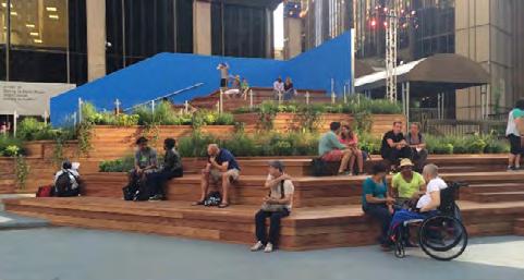
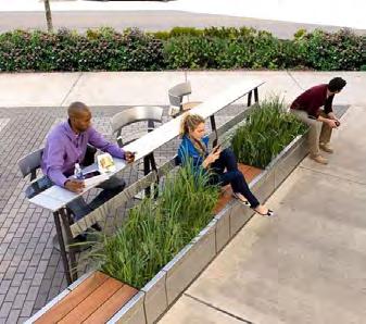
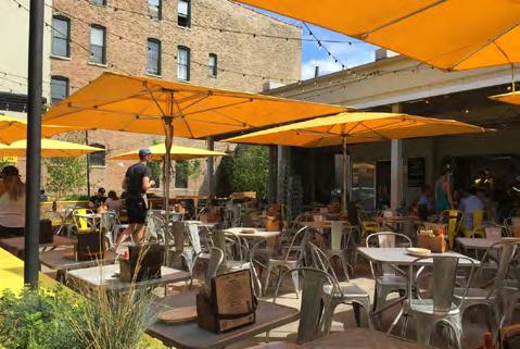
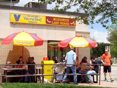
5 5. SIGNAGE: 6. AMENITIES: 7. SAFETY: 8. OUTDOOR DINING: Navigation from place to Pedestrian and bike Safety is crucial and should In the Midwest, where place is an integral part amenities should be be thoughtfully considered the warm seasons are of everyday life. People further integrated and for all users and furthered limited, outdoor dining is use their knowledge and follow a design to respect via lighting, pedestrian especially dear as a way to previous experiences to the distinctiveness of and bike amenities, enjoy community, friends, find their way in the built the districts. The Village crossings, bump-outs, etc. and neighbors. Outdoor environment. Signage is key can also continue to Future design guidelines dining is important to for welcoming visitors (at provide and maintain should be integrated with many residents and visitors gateway locations) as well street amenities including the recommendations (ranked #1 via the online as orienting and directing benches, interesting contained in the quick poll). Creative users to destinations and seating, creative / Transportation Plan to integration should be parking. Wayfinding signage interactive public art, successfully plan for explored via parklets (in does just that, it helps planters, trash containers, the interplay between Hubbard Woods), corner visitors find their way, get recycling and water pedestrians, cyclists, and plazas, sidewalk patios around, and understand fountains to ensure motorists. A variety of tools (where the right-of-way the business districts. It also business districts invite are available to achieve allows), and temporary sets a tone for what people users to stay and enjoy. the desired characteristics pop-up cafes at community feel and think when they including signage, events. come to Winnetka. Signage intersection treatments, must be focused and crossing treatments, thoughtfully considered to buffers, and traffic calming. celebrate Village character and not appear cluttered or confusing. An important consideration is also user distinction i.e. residents, who understand their way around, versus visitors who may be unfamiliar with the districts. WINNETKA DOWNTOWN PLAN 55


6 DISTRICT-SPECIFIC RECOMMENDATIONS In addition to the overarching themes that should be applied at a macro-level and considered for each of Winnetka s three business districts, there are district specific recommendations to be applied at the micro-level. These ideas are aimed at advancing the Vision for each district and were developed over the course of the planning process. Throughout that effort, the varying environments, users, site characteristics, economic drivers, and design opportunities for the business districts were reviewed, refined, and revisited. Solidifying the Vision Statements for each of the business districts early in the process provided the framework from which detailed recommendations followed. The urban design elements can represent opportunities to make the districts more appealing to support a stronger commercial market. In many instances the enhancements correspond to recommended transportation improvements indicating that the appearance of pedestrian, bicycle, and autorelated infrastructure are ways to enhance the character of the areas. The district-specific recommendations highlight three primary features: CONTEXT: Good urban design always arises from a thorough and caring understanding of place and context. How does the district function? What primary roles does it serve entertainment, civic, leisure? How is it used and by whom? What are the site constraints, opportunities, and capacity for development? KEY LOCATIONS: Good urban design includes aims, targets, and objectives. The aims are the Visions and themes addressed previously. The targets are the key locations, i.e. intersections, parks, and places, where people tend to congregate, activity is focused, and where urban design improvements should be concentrated. The objectives are the urban design recommendations explained below. URBAN DESIGN OBJECTIVES: The urban design objectives help further the sort of place each district hopes to become via physical development and coordinated improvements. The objectives for each district are different because they reflect the unique circumstances of the particular place. Downtown Elm Street is a municipal hub, Hubbard Woods is family / design-oriented, and Indian Hill is a gateway into Winnetka, with the primary user being New Trier High School students. 56 WINNETKA DOWNTOWN PLAN


 Dwyer Park, a desirable destination for residents and families, and (4) Station")
7 ELM STREET ELM STREET The Elm Street business district is the main hub and heart of Winnetka s business and civic community. Visually and symbolically it is bisected by Green Bay Road and the Union Pacific Railroad. The district has a very pedestrian feel with sidewalks that provide ample room for pedestrian flow and streetscape features, neighborhood shops, and local restaurants. That said, the crossing of Green Bay Road by pedestrians and cyclists at Elm Street using the bridge / Metra overpass is perceived as daunting. The area west of Green Bay Road most notably includes (1) the Post Office site, which presents a major development opportunity for the Village, (2) Chestnut Court / Moffat Mall, which sits just west of Village Hall and is a defining landmark that will inform surrounding development and urban design improvements, (3) Dwyer Park, a desirable destination for residents and families, and (4) Station Park, which lies across from Village Hall next to the Metra Station. The area east of Green Bay Road is walkable, similarly scaled to the west side and includes a potential development site at the intersection of Elm Street and Lincoln Avenue that will affect future development and market opportunities. The Green Bay Trail, which runs north south, lies just east of the Metra tracks, connecting to the area to both Hubbard Woods and Indian Hill. WINNETKA DOWNTOWN PLAN 57

8 ELM STREET KEY LOCATIONS The map below identifies the key locations, intersections and sites where urban design improvements should primarily be focused in the Elm Street district. These locations were identified as top priorities via feedback and discussion during the Downtown Master Plan process. 58 WINNETKA DOWNTOWN PLAN
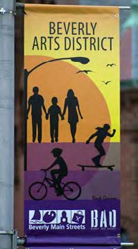
9 ELM STREET URBAN DESIGN OBJECTIVES SIGNAGE WAYFINDING PLAN: The value of helping visitors coming to Winnetka find their way to shops, businesses, and parking has been often reiterated in this Plan and is certainly an important urban design element. The Village s existing plans for wayfinding should be coordinated with this Plan and implemented to help everyone find destinations in the districts; prior to improving Village signage (gateway, wayfinding, parking, etc.), an overall wayfinding program is recommended for the Village. Wayfinding and directional signage can better orient users to locations on both sides of Green Bay Road, Community House, Dwyer Park, the Metra Station, Green Bay Trail, public parking lots, and other key destinations in downtown. INSTALL GATEWAY SIGNAGE: Opportunities to enhance welcome signage into the core business district of the Village should be incorporated at key locations such as Green Bay Road and Oak Street, as well as Green Bay Road and Spruce Street. Parking: Review, refine, and simplify parking standards, signage and location by user type. As noted in the Transportation chapter, it is important for visitor parking to take precedent over employee and commuter parking to further foot traffic and activate the district. Additionally, a consistent design and clear message needs to be applied so that restrictions are easily understood for public parking lots and street parking. Private Signage: Continue to encourage creative integration of signs (such as blade signs) for commercial storefronts. Light Pole Banners: Continue to further celebrate district identity and unification between districts via banners on light poles. Banners may be location, event, holiday. or sponsor specific. Kiosk: Consider locating additional kiosks in the Elm Street district at key locations or near outdoor people places where there is a high amount of foot traffic and visibility. There is an existing display at Oak Street and Green Bay Road, additional locations and design of kiosks should be explored (potential location: future development of Post Office site). WINNETKA DOWNTOWN PLAN 59
10 ELM STREET URBAN DESIGN OBJECTIVES PEDESTRIAN AMENITIES CONNECTIVITY + SAFETY: East-west connections should be enhanced via intersection improvements and curb extensions at Elm Street and Green Bay Road and bridge enhancements / sidewalk widening as shown in the Transportation chapter. Likewise, pedestrian amenities that cater to user safety, access, and circulation at key locations should be added as appropriate. Specialty Pavers: Incorporate pavers at all four crossings at intersection of Green Bay Road and Elm Street to further identify pedestrian environment; continue decorative paving across bridge as noted in the Transportation chapter. Bump-outs/Curb Extensions: Add these elements to create a more pedestrian friendly environment at the intersections of Green Bay Road and Elm Street, Green Bay Road and Oak Street, and along bridge going over Metra as noted in the Transportation chapter. Bollards: Consider adding bollards at Green Bay Road and Elm Street to further pedestrian safety. Crosswalks: Add and repaint if fading. BIKE AMENITIES BIKE PARKING: Integrate attractive bike parking at some of the key locations in Downtown. Include intersections east and west of the Metra Station on Elm, Dwyer Park and Metra Station (improve existing); also incorporate into future development of Post Office Site. Bike parking also should be considered at the intersections of Elm Street and Lincoln Avenue, and Elm Street and Chestnut Street. Creativity: Bike racks can be a creative options to also serve as public art and provide an opportunity to further community identity (see idea board). Repair Station: Consider installing an air/fill repair station near the Green Bay Trail. Bike Plan: Coordinate with the adopted Park District Bike Plan for overall recommendations on circulation. Green Bay Trail Connectivity: Further pedestrian and bike connections between commercial districts via the Green Bay Trail. 60 WINNETKA DOWNTOWN PLAN
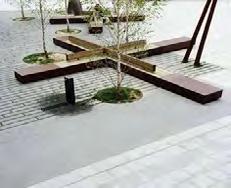
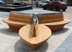
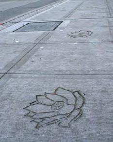
11 ELM STREET URBAN DESIGN OBJECTIVES BUILT + NATURAL AMENITIES PEOPLE PLACES: Creating comfortable environments for visitors includes elements large and small. Attention to detail helps define the character of and includes integrating plazas, benches, creative seating, outdoor patios and other amenities at key locations; and includes design elements such as bollards and landscaping that enhance safety, further attractive sight lines, and buffer users from traffic and noise. Public Art / Sculptures: Explore opportunities for art installations, sculptures and / or interactive and potentially kid-friendly fixtures at key locations specifically the Post Office site. Trash / Recycling Receptacles: These elements are already installed and should be integrated as needed in the future relative to the Post Office site and development at Elm Street and Lincoln Avenue. Landscaping: Year-round landscaping is a high priority for the Village as noted via community engagement. Key locations should continue to integrate and maintain landscape treatments that respond to the surrounding environment by providing greenery, shade, and a sensory experience for users. Shrubs and landscape buffers should be incorporated at the edges of plazas and outdoor patios to buffer users from parking and traffic. Shade and ornamental trees should be added and maintained along sidewalks and surrounding plazas. Planters should continue to be integrated at corners. Street Furniture: Continue to integrate outdoor benches, tables, and seating options at key locations. Consider exploring creative options at plazas and where space allows. Special consideration of opportunities should be applied to the future development of the Post Office site (see idea board). Seasonal Opportunities: Continue installation of holiday lights, but also explore opportunities to embrace seasons with unique planter creations, light pole banners, etc. Building Plaques: Celebrate the history of significant structures via more building plaques at the street level that tell a story (see idea board). Pavement Stampers: Further Village / district identity at key locations via concrete stampers or inlaid designs (see idea board). WINNETKA DOWNTOWN PLAN 61


12 ELM STREET IDEA BOARD 62 WINNETKA DOWNTOWN PLAN


13 HUBBARD WOODS Hubbard Woods is a linear business district built on both sides of a regional arterial roadway, Green Bay Road. The district is a major yearround destination due to Hubbard Woods Park and shopping options. It serves as the northern gateway into Winnetka (at the intersection of Scott Avenue and Green Bay Road) and shares its border with Glencoe. Based on the narrower street width of Green Bay Road in Hubbard Woods, it has a more intimate feel than the Elm Street District. It also has narrower sidewalks though, which limits opportunities to expand ground-level streetscape amenities and outdoor seating. That said, Hubbard Woods is walkable, family-friendly and ideal for shopping, playing at, or attending events in Hubbard Woods Park. Parking is primarily provided via on-street parallel spaces. There is also a two-level parking structure adjacent to the railroad tracks at Merrill Street and Tower Court, but it is difficult to access due to existing circulation and traffic patterns around the park at Merrill Street / Gage Street / Tower Court, The Hubbard Woods Metra Station and Green Bay Trail lie on the east side of the District. A public parking lot is located at the south end of the district on Tower Road. WINNETKA DOWNTOWN PLAN 63

14 KEY LOCATIONS The map below identifies the key locations, intersections and sites where urban design improvements will primarily be focused in Hubbard Woods. The locations noted were identified as top priorities via feedback and discussion during the Downtown Master Plan process. As such, the locations provide significant opportunities for enhancement to advance the vision. 64 WINNETKA DOWNTOWN PLAN
15 HUBBARD WOODS URBAN DESIGN OBJECTIVES SIGNAGE WAYFINDING PLAN: As with the Elm Street District, Hubbard Woods can benefit from improved wayfinding. While many of the destinations in the district are located directly along Green Bay Road, some can be challenging to find for first time or occasional visitors. This is especially true of the Metra Station and Hubbard Woods parking deck. GATEWAY SIGNAGE: An opportunity exists to add welcome signage to the Village at Green Bay Road and Scott Avenue. Similar signage announcing entry to the Hubbard Woods District could be located at Green Bay Road and Tower Road, and / or Green Bay Road and Merrill Street. WAYFINDING / DIRECTIONAL SIGNAGE: Signage to better orient users to Hubbard Woods parking garage (a formal name for which should be determined and commonly applied), Hubbard Woods Park, Metra, Green Bay Trail, and other key destinations can be added to enhance understanding and comfort in the district for all visitors. Parking: Review and refine signage and location by user type; visitor parking takes precedent over employee and commuter. Again, directing visitors to the Hubbard Woods parking garage is a particular need. Private Signage: Continue to encourage creative integration of pedestrian oriented blade signs for commercial storefronts. Light Pole Banners: Further celebrate district identity and unification between districts via banners. Banners may be location, event, holiday, or sponsor/ business specific; consider Hubbard Woods Design District. Kiosk: Consider locating one or more additional kiosks in Hubbard Woods at key locations or near outdoor people places where there is a high amount of foot traffic and visibility. Possible locations include at Hubbard Woods Park and / or near Tower Road and Green Bay Road. WINNETKA DOWNTOWN PLAN 65
16 HUBBARD WOODS URBAN DESIGN OBJECTIVES PEDESTRIAN AMENITIES CONNECTIVITY + SAFETY: Pedestrian circulation can be enhanced around the Metra Station, Hubbard Woods Park, Green Bay Trail, and the intersection of Tower Road and Green Bay Road, which is particularly daunting. Specialty Road/Shared Street: Consider adding decorative paved crossings at Green Bay Road and Tower Road to further the pedestrian environment. Consider making the stretch of Tower Court adjacent to Hubbard Woods Park and the Metra Station a paved corridor for utilization as a shared street for special events. Bump-outs/Curb Extensions: These elements can be added at the intersection of Green Bay Road and Tower Road, Green Bay Road and Merrill Street, and Green Bay Road and Gage Street. Similarly, parking spaces along Green Bay Road in Hubbard Woods can be reorganized to allow for the creation of additional bump-outs for landscaping or outdoor seating. Bollards: Integrate bollards at key locations around park to further safety of pedestrians and children; consider additional at intersection of Green Bay Road and Tower Road. Crosswalks: Add and repaint if fading BIKE AMENITIES BIKE PARKING: The family oriented nature of the district is a point of emphasis for integrating bike amenities such as attractive bike parking at key locations. Particular attention is appropriate to opportunities at both the north and south ends of Hubbard Woods. At the north end, explore creative, family-friendly bike racks near Hubbard Woods Park. At the south end (near Green Bay Road and Tower Road) explore bike racks that celebrate the design district. Creativity: Create options for bike racks may also serve as public art and help further celebrate the Hubbard Woods Design District (see idea board). Identity: Bike racks provide an opportunity to further community identity. Bike Repair: Consider an air / fill station near the Green Bay Trail (one at bike shop). Bike Plan: Coordinate with the adopted Park District Bike Plan for overall recommendations on circulation. Green Bay Trail Connectivity: Further pedestrian and bike connections between commercial districts via Green Bay Trail. 66 WINNETKA DOWNTOWN PLAN
17 HUBBARD WOODS URBAN DESIGN OBJECTIVES BUILT + NATURAL AMENITIES PEOPLE PLACES: Due to the narrow width of sidewalks in Hubbard Woods, opportunities to create people places at intersections and along the right of way are limited. Encourage integration of creative seating, outdoor patios, public art, and accent landscaping via parklets within requirements for future development proposals. PUBLIC ART: A key characteristic of Hubbard Woods is its family-friendly and design-centric nature. As such, there are opportunities to celebrate this via public art at key locations, gateways, and vistas. The Village may also consider temporary art installations at Hubbard Woods Park to replace annually as noted in the examples below. Trash / Recycling Receptacles: With the newly renovated park and additional park programming to further activate the district, trash and recycling receptacles can be added to ensure they are keeping up with increased use / community events. Landscaping: Consider consolidating or grouping planters that are currently located within the sidewalk and in front of storefronts to bump-outs and parklets; this will improve the ease with which people can walk and shop. Seasonal Opportunities: In addition to holiday lights, explore opportunities to embrace seasons with unique planter creations, light pole banners, etc. Building Plaques: Celebrate the history of significant structures via building plaques at the street level that tell a story. Concrete Stampers: Further district identity at chosen, high traffic intersections that celebrate Hubbard Woods Design District. WINNETKA DOWNTOWN PLAN 67


18 HUBBARD WOODS IDEA BOARD 68 WINNETKA DOWNTOWN PLAN


19 INDIAN CONTEXT HILL Winnetka s Indian Hill Business District is an auto-oriented business corridor that serves as the southern gateway into the Village, sharing its border with Kenilworth. Other than a small sign, there is no real gateway welcome. The Metra / Indian Hill station sits on the east side of Green Bay along with a large commuter parking lot, the primary users of which are students heading to and from New Trier High School. The Illinois Department of Transportation recently installed traffic, safety, and signal improvements at the intersection of Winnetka and Green Bay. Green Bay Trail runs north-south along the UP-N railroad tracks, just east of Green Bay Road. The most significant opportunities present in Indian Hill is to install signage (both wayfinding and gateway), complimentary landscaping, and explore the retrofit / reuse of the Village owned garage structure on the southeast corner of Winnetka Avenue and Green Bay Road. WINNETKA DOWNTOWN PLAN 69

20 INDIAN HILL KEY LOCATIONS The map below identifies key locations, intersections, and sites where urban design considerations are appropriate in the Indian Hill district. These locations were identified as top priorities via feedback and discussion during the Downtown Master Plan. While outside the study area, New Trier High School certainly impacts the district. 70 WINNETKA DOWNTOWN PLAN
21 INDIAN HILL URBAN DESIGN OBJECTIVES SIGNAGE WAYFINDING PLAN: Further developing the wayfinding concepts noted in the Plan are an important step to understanding each business districts built environments and where information is needed to maximize legibility of the wayfinding system. As part of the overall wayfinding program indicated in this Plan. This southern gateway should receive consideration of how visitors can be directed to key locations such as the Elm Street District and New Trier High School. GATEWAY SIGNAGE: Enhancing the existing welcome signage at southeast corner of Green Bay Road and Winnetka Avenue can be accomplished by adding a more robust, site specific gateway sign closer to the intersection. This site was initially acquired by the Village for use as a gateway, and this Plan recommends pursuing that option. This will involve adding landscaping and signage that is highly visible and provided a special announcement that those coming north on Green Bay Road have reached Winnetka. WAYFINDING / DIRECTIONAL SIGNAGE: Signs should better orient users to New Trier High School, Downtown Elm, Green Bay Trail, Metra, and other notable destinations (North Shore Country Day and Music Institute) via wayfinding signage. Further pedestrian and bike connections between business districts via Green Bay Trail can also be highlighted. During the Downtown Master Plan process, it was noted that New Trier High School hosts many state-wide sporting events that draw thousands of visitors from across the state to Winnetka. But due to lack of wayfinding signage, visitors may not realize the proximity of Downtown Winnetka and the restaurants therein. Thus potential sales tax dollars may be leaving the Village due to lack of wayfinding / directional signage. Light Pole Banners: Further celebrate district identity and unification between districts via banners on light poles. Banners may be location, event, holiday, or sponsor specific. WINNETKA DOWNTOWN PLAN 71
22 INDIAN HILL URBAN DESIGN OBJECTIVES PEDESTRIAN BIKE BUILT + NATURAL AMENITIES PEOPLE PLACES: In addition to further celebrating the entry into Winnetka via gateway signage near the intersection of Green Bay and Winnetka Avenue, that site (as highlighted in orange on the Key Location Map) is large enough to accommodate additional improvements that could cater to the high amount of student users, generate activity, and make the entry vista more of a people place. Potential improvements include retrofitting the existing building into a walk-up student led or student oriented shop (example: container café for coffee, gelato, etc.). If created into more of a destination, additional pedestrian amenities including patio seating, bike parking, benches, and festoon lighting should be considered; parking would also need to be addressed. Furthermore, landscaping should be installed at edges to buffer users from traffic and provide greater comfort / safety. *** Ideas noted through the Downtown Master Plan outreach support this initiative: 1) Parents of Winnetka want more places for their teens to be able to spend time and 2) in addition to the desire for more restaurants and places to go out to eat, an ice cream / gelato shop was a specific desire noted many times over. *** Public Art: Consider the installation of a sculptural art element at gateway corner and consider a mural at the underpass. Consider art projects being led by New Trier High School Art classes. Landscaping: Integrate accent landscaping on east side of Green Bay leading up to Winnetka Avenue to compliment signage and provide attractive gateway approach into Winnetka. Student Run Community Garden: Consider coordinating with New Trier High School to make the gateway a pilot program for a student run community garden that could include a patio with picnic tables to enjoy lunch. The existing structure could become a tool shed and farmers stand to sell harvested goods and students could engage the community about urban farming / sustainable practices. 72 WINNETKA DOWNTOWN PLAN


23 INDIAN HILL IDEA BOARD WINNETKA DOWNTOWN PLAN 73


24 URBAN DESIGN CONCLUSION Emphasizing the business districts role as people places can, in part, be advanced through application of the urban design concepts described in this chapter. The enhancements to public and private spaces include elements such as new signage, pedestrian improvements, and street furniture (benches, kiosks, planters, etc.). Proposed improvements build on past plans, reflect the unique character of each business district, and create a consistent application of Village-wide wayfinding and gateways. Implementation of the urban design recommendations are intended to advance the district Visions Statements and build on the Village s history and physical characteristics. 74 WINNETKA DOWNTOWN PLAN
BUSINESS DISTRICT DESIGN GUIDELINES
 Des Plaines, Illinois Prepared for the City of Des Plaines by: The Lakota Group Laurie Marston, AICP March 2005 Section 5: Streetscape Elements Business District Design Guidelines STREETSCAPE ELEMENTS
V. Gateways GATEWAYS / V-1
 V. GATEWAYS / V-1 Many of Chesapeake s gateways are located on highways and call for bold and attractive designs that motorists can understand, appreciate, and enjoy. can also take the form of natural
Elm Street Business District: Streetscape and Signage Plan
 Elm Street Business District: Streetscape and Signage Plan VILLAGE OF WINNETKA DOWNTOWN MASTER PLAN TASK FORCE MTG #1 Teska Associates 30 October 2017 AGENDA 1. Introductions and Walking Tour 2. Past Streetscape
Urban Design 9Identity
 Urban Design 9Identity URBAN DESIGN IDENTITY Urban design is about connecting people to their places through the built environment, nature, and overall urban form. Done well, it creates a memorable space
Community Design Plan
 Gardena General Plan 2006 Authority While the is not a required element of a General Plan, it is included because improving the community appearance and image is paramount to the overall quality of life
PUBLIC RIGHT-OF-WAY IN THIS CHAPTER PUBLIC REALM
 PUBLIC RIGHT-OF-WAY This section provides design guidelines for improvements in the public right-of-way. The public right-of-way refers to streets, sidewalks, non-vehicular thoroughfares, parks and greenways
Policies and Code Intent Sections Related to Town Center
 Policies and Code Intent Sections Related to Town Center The Town Center Vision is scattered throughout the Comprehensive Plan, development code and the 1994 Town Center Plan. What follows are sections
Town Center (part of the Comprehensive Plan)
") Town Center (part of the Comprehensive Plan) Mercer Island Town Center Looking North (2014) In 1994, a year-long process culminated in a set of design guidelines and code requirements for the Town Center
Town Center (part of the Comprehensive Plan) Mercer Island Town Center Looking North (2014) In 1994, a year-long process culminated in a set of design guidelines and code requirements for the Town Center
A Vibrant Downtown. Chapter 5 Cary Public Art Opportunities 31
 A Vibrant Downtown Cary s vision for Downtown is a unique, vibrant, dynamic, pedestrian friendly location; a regional destination and a place to live, work, and recreate, according to the 2001 Town Center
VILLAGE OF SKOKIE Design Guidelines for Mixed-Use Districts NX Neighborhood Mixed-Use TX Transit Mixed-Use CX Core Mixed-Use
 VILLAGE OF SKOKIE Design Guidelines for Mixed-Use Districts NX Neighborhood Mixed-Use TX Transit Mixed-Use CX Core Mixed-Use TABLE OF CONTENTS CHAPTER 1 SITE DESIGN Purpose 1 CHAPTER 2 SITE DESIGN Streetscape
Table of Contents. Elm Avenue Improvement Plan City of Waco, Texas. Introduction 1. Existing Context 1 Figure 1 2.
 Table of Contents Introduction 1 Existing Context 1 Figure 1 2 Plan Guidelines 3 Future Urban Form 4 The West-End 4 Main Street 6 The East-End 7 Figure 2 9 Public Improvement Recommendations 7 General
City of Farmington. Downtown Plan. Amendment to the 1998 Master Plan Adopted October 11, 2004
 City of Farmington Amendment to the 1998 Master Plan Adopted October 11, 2004 Introduction Planning Background 1 Scope and Components of the Plan Amendment 2 Concept Introduction 3 Plan Concepts 3 Conceptual
THE CIVIC DISTRICT DEVELOPMENT OPPORTUNITIES
 1 THE CIVIC DISTRICT DEVELOPMENT OPPORTUNITIES The Civic District is the physical and emotional heart of the downtown. It is also a major gateway into the central core, establishing the image and identity
3.1 community vision. 3.3 required plan elements
 Chapter 3 Community Form 3.1 community vision 3.2 Parks & landscaping concepts 3.3 required plan elements D R A F T 20 Community Form Chapter 3 3.0 Community form 3.1 community vision The Specific Plan
The Vision. Photo provided by The Minervini Group. 46 Vision, Objectives & Strategies
 Vision, Objectives & Strategies The is the public framework and guide for future development of the Grand Traverse Commons. The establishes public polices for infrastructure, the preservation of natural
Wayfinding. North Gateway: Integrate a vertical gateway marker on the west side of Ward Street at the south corner of Vernon Street.
 3.3.6.2 Wayfinding Existing Conditions Wayfinding signage is important to direct visitors and tourists to different locations in the downtown. A significant part of the wayfinding signage in the downtown
GREENING THE BOULEVARD Master Plan Concepts for Venice Boulevard between Lincoln and Sawtelle
 GREENING THE BOULEVARD Katherine Spitz Associates Inc. 4212½ Glencoe Avenue Marina Del Rey, CA 90292 310 574 4460 Fax 574 4462 January 2008 Table of Contents Overview Proposed Design Improvements Illustration
COMPLETE GREEN STREET CHECKLIST
 COMPLETE GREEN STREET CHECKLIST This document was developed to dissect the structure of an urban street and explore opportunities to make our streets more complete while also integrating green street strategies.
Maplewood Avenue Downtown Complete Street Project
 Maplewood Avenue Downtown Complete Street Project Second Public Meeting January 24, 2018 Welcome and Introduction of Project Team City Planning and Public Works Staff City of Portsmouth Juliet Walker Planning
Small Area Plan. South Gateway
 Small Area Plan Adopted May 12, 2008 South Gateway Purpose. The South Gateway Small Area Plan defines the City s expectations for the future of the southern entrance to the City at Interstate 85 and Highway
VEHICULAR AND PEDESTRIAN CIRCULATION
 This perspective sketch communicates the intended character and quality of a proposed streetscape design. Locate benches near a major intersection where people tend to gather. Seating and lighting provide
open house 3 CITY OF SALEM Downtown Streetscape Plan
 open house 3 Streetscape concepts CITY OF SALEM Downtown Streetscape Plan analysis concepts we are here refined concepts & document Feb 13th 1 2 3 apr 18th KICKOFF OPEN HOUSE Streetscape Work Group Walking
Fifth and Detroit Street Design May 2017 Capital Improvements Committee. DOWNTOWN Street Design
 1 Fifth and Detroit Street Design May 2017 Capital Improvements Committee Agenda 2 Review Street Configuration Prior Meeting Review Outreach Synopsis Functional Street Design Refinements Curb Edge, Turning
Figure 3-1: Public Realm Plan
 3 Public Realm Figure 3-1: Public Realm Plan 3.1 Public Realm Concept The public realm concept for the Little Mountain site integrates a clear and accessible movement network with public spaces for social
hermitage town center
 hermitage town center A Community Vision prepared by Strada for The City of Hermitage and The Mercer County Regional Planning Commission January 2007 table of contents introduction 3 design principles
Lehigh Acres Land Development Regulations Community Planning Project
 Lehigh Acres Land Development Regulations Planning Effort Summary In July, 2010 Commissioner Frank Mann invited the Lehigh Acres community to start discussing how to achieve their recently adopted community
4.9 Mendocino Avenue Corridor Plan Design Guidelines
 4.9 Mendocino Avenue Corridor Plan Design Guidelines The Mendocino Avenue Corridor Plan addresses the area between College Avenue and Steele Lane. Mendocino Avenue is a busy arterial that runs parallel
MASTER PLAN QUEEN ST. WEST BIA
 QUEEN ST. WEST BIA MASTER PLAN QUEEN ST. WEST BIA EXECUTIVE COMMITTEE IN ASSOCIATION WITH PMA LANDSCAPE ARCHITECTS LTD. SWEENY STERLING FINLAYSON & CO ARCHITECTS INC. FUGITIVE GLUE MARCH 2013 4.5.4 PLAZA
Pedestrian and Bike Bridge LOGO
 6.2.2 Pedestrian and Bike Bridge The proposed pedestrian and bike crossing re-envisions the existing bridge at Pismo Creek on Cypress Street. The bridge is currently underutilized by vehicular through
City of Plattsburgh DRI: Downtown Streetscapes & Riverfront Access. Downtown Streetscape and Riverfront Access Design
 City of Plattsburgh DRI: Downtown Streetscapes & Riverfront Access Welcome Thank you for coming this evening. Agenda PART I - Project Context The Downtown Revitalization Program Our DRI Projects Other
38 Queen s University Campus Master Plan Part 1
 38 Queen s University Campus Master Plan Part 1 46 The Campus at the City Scale Chapter 4 The Campus at the City Scale 39 Queen s is an urban University centrally located in Kingston. Decisions made by
Neighborhood Districts
 NEIGHBORHOOD DISTRICTS SEVEN MAIN DISTRICTS Neighborhood Districts While the Development Plan provides a broad-scale overview of the neighborhood, this section focuses on uses and relationships at the
Transportation. Strategies for Action
 Transportation A major priority for the Overlake Neighborhood is to develop a multimodal transportation system. To achieve this system, a balance has to be found among travel, circulation and access needs;
Streets Vision
 streets 86 2.9 Vision : The Most Prevalent and Important Public Spaces Fixed routes of human travel have served as corridors for commerce and places for human interaction from the earliest trails and foot
Sheridan Boulevard S TAT I O N A R E A P L A N S H E R I D A N B O U L E VA R D S TAT I O N A R E A P L A N
 Sheridan Boulevard S TAT I O N A R E A P L A N 1 City of Lakewood Adopted November, 2006 S H E R I D A N B O U L E VA R D S TAT I O N A R E A P L A N The Vision The City of Lakewood s overall vision is
Guiding Principles. People dance, and to share culture. Place consistency and internal connections. Management community for years to come
 3. The Campus Concept This chapter presents an overview of the Campus Concept from the formulations of its guiding principals through general recommendations to facilitate the triple urban design plan
ARLINGTON COUNTY, VIRGINIA
 ARLINGTON COUNTY, VIRGINIA County Board Agenda Item Meeting October 15, 2005 DATE: September 28, 2005 SUBJECT: Request to Advertise the adoption of the 2005 Clarendon Sector Plan C. M. RECOMMENDATION:
VISION AND GUIDING DESIGN PRINCIPLES
 pleasure point commercial corridor VISION AND GUIDING DESIGN PRINCIPLES Public Draft November 26, 2018 County of Santa Cruz with assistance from MIG CONTENTS PART I: INTRODUCTION AND VISION... 3 Community
7Page 91 CLEMMONS COMMUNITY COMPASS 7 COMMUNITY CHARACTER
 7 Community Character The beauty of Clemmons won t necessarily be a reflection of our past, but our future. This quote from Comprehensive Plan Steering Committee member Wayne Dodson captures the essence
Public Art Plan. We have elected to submit Public Art Plans before or concurrently with the CSP Submittal per the FDP Manual
 Public Art Plan The intent of the Horizon Uptown Public Arts Program is to create great places that engage the community and leverage the neighborhood development and economic vitality. The Horizon Uptown
New York Avenue Streetscape and Trail Project Public Meeting #1 Summary
 New York Avenue Streetscape and Trail Project Public Meeting #1 Summary I. King Jordan Student Academic Center (SAC) Gallaudet University, Washington, DC February 23, 2017 Table of Contents 1.0 Introduction...
Community Assistantship Program. Milaca Downtown Revitalization
 Community Assistantship Program Milaca Downtown Revitalization Prepared in partnership with City of Milaca Prepared by Zachary Jorgensen Research Assistant University of Minnesota December, 2009 CAP Report
Chapter 14 Streetscape Improvements
 This chapter presents streetscape design concepts for key streets and gateways in the Downtown Specific Plan area. This chapter is organized as follows: 14 Streetscape Improvements 14.1 Streetscape Treatments
Chinatown. Green Street Demonstration Project. land + water. community
 Chinatown Green Street Demonstration Project land + water community 2 Purpose. Dear Stakeholder, Thank you for your interest in making our neighborhood a greener, more sustainable, and attractive place
Urban Design & Placemaking
 Urban Design & Placemaking What is Urban Design? Urban Design is the discipline of creating equitable, vibrant, and sustainable places with distinct identities. The profession pulls from other built environment
Introduction. Community Outreach Approach. Sacramento Valley Station Master Plan. Online Questionnaire Summary of Feedback.
 Introduction Located in the northwest sector of downtown Sacramento, the Sacramento Valley Station (SVS) is the primary rail station in northern California and the seventh busiest station in the country.
Roanoke Rapids Streetscape Master Plan. City Council Presentation
 SCHEDULE: Stakeholder Meeting/Kick off November,2016 Master Planning Phase (November March 2017) Public Meeting #1 December 13, 2016 Review Meeting with Key Stakeholders Refine Concepts Based on Input
Ivywild On The Creek PRELIMINARY CREEK DISTRICT MASTER PLAN
 Ivywild On The Creek PRELIMINARY CREEK DISTRICT MASTER PLAN Introduction: Rejuvenating an extraordinary Creekside neighborhood THE CREEKSIDE DISTRICT The Ivywild On The Creek Neighborhood District Master
Carlsbad Village Redevelopment Concept Summary of Features
 Carlsbad Village Redevelopment Concept Summary of Features Calthorpe Associates November 5, 2003 The Redevelopment Concept illustrates a vision for the future of Carlsbad Village. The overall vision of
Vision Plan Kickoff Meeting Summary Report
 Vision Plan Kickoff Meeting Summary Report October 2018 The Vision Plan With the redevelopment of the Amtrak Property, Penn Station Partners (PSP) seeks to build on the creative talent and entrepreneurial
LUNDY S LANE COMMUNITY IMPROVEMENT PLAN STUDY
 PUBLIC INFORMATION MEETING #2 October 12, 2016 LUNDY S LANE COMMUNITY IMPROVEMENT PLAN STUDY AGENDA 5:00 to 5:30pm: Open House 5:30 to 6:15pm: Presentation 6:15 to 7:00pm: Individual paced workshop with
Dyersville Downtown Plan. Open House October 24, 2017
 Dyersville Downtown Plan Open House October 24, 2017 What is a Comprehensive Plan? - Vision - Guidance for decisions - Basis for regulations What is a Downtown Plan? - Understand priorities - Identify
GUIDING PRINCIPLES IN THIS CHAPTER
 GUIDING PRINCIPLES The guiding principles and design concepts in this chapter work together with the Chapel Hill 2020 Comprehensive Plan to support new public places that can be enjoyed by all while also
To ensure human scale design, the towers step back from the facade of the building after four stories.
 41 40 SPRING GARDEN WEST A DESIGN BY PUBLIC ENGAGEMENT Chapter 3 Design SETBACK (SPRING GARDEN WEST LOOKING SOUTH) To ensure human scale design, the towers step back from the facade of the building after
Figure Example of out door dining in the public right-of-way.
 Section 2 Core Area Goal 2.2.1 To maintain and enhance the character of existing streets in the Downtown Area. Character Figure 2.2.1 Example of out door dining in the public right-of-way. A. Provide street
WEST LOOP DESIGN GUIDELINES CHECKLIST
 WEST LOOP DESIGN GUIDELINES CHECKLIST Section 1.0 General Strategies 1.1 DESIGN EXCELLENCE: ENCOURAGE HIGH QUALITY AND INNOVATIVE DESIGN OF NEW BUILDINGS WITHIN THE WEST LOOP WITHOUT BEING PRESCRIPTIVE
The Lincoln Neighborhood Corridor Plan. The LiNC
 October 1, 2014 Planning Commission Study Session The Lincoln Neighborhood Corridor Plan The LiNC Purpose of Tonight s Meeting Introduction to The LiNC Review of Existing Conditions and Community Identified
2.0 THE PLATINUM TRIANGLE VISION
 2.0 THE PLATINUM TRIANGLE VISION The envisions an exciting future for the area surrounding Angel Stadium of Anaheim, the Honda Center and The Grove of Anaheim. 2.1 Planning Principles In order to further
Elm Street Business District: Streetscape and Signage Plan
 Elm Street Business District: Streetscape and Signage Plan VILLAGE OF WINNETKA DOWNTOWN MASTER PLAN VILLAGE COUNCIL MEETING Final Streetscape & Signage Planning Teska Associates 04 June 2018 WHY WE RE
SOUTH UNIVERSITY Street Design Alternatives in Progress
 1 Alternatives in Progress 2016.01.20 Meeting Agenda 2 1. Progress & Schedule 2. Utilizing the Street Design Manual 3. Site Characteristics and Input Received 4. Street Geometry What can we accomplish
Draft Memorandum #1: Goals and Vision for Revitalization
 Keizer Revitalization Plan Draft Memorandum #1: Goals and Vision for Revitalization Submitted to: City of Keizer April 12, 2018 (revised) Prepared By: Angelo Planning Group and Otak, Inc. Project No. 17482.A
A. Background Summary of Existing Challenges and Potential Possibilities. 1. Summary of Existing Assets and Potential Opportunities
 A. Background 1 A Main Street Master Plan Study was performed and completed in October of 2007. The study was initiated to review current land uses and development patterns along Main Street, from Parrish
The Lower SaLuda Greenway
 The Lower SaLuda Greenway InITIaTIve a FLourIShInG Greenway. a hub For economic GrowTh. a ConneCTIon BeTween CoMMunITIeS. In April 2017 the Michael J. Mungo Foundation and Lexington County commissioned
Hockessin Community Redevelopment Plan
 Hockessin Community Redevelopment Plan 3.1 Introduction The Community Redevelopment Plan for the Village of Hockessin is the result of the people s vision for a distinct village center that serves as the
Hamilton Road Corridor Streetscape Master Plan. Open House October 4 th, 2017
 Hamilton Road Corridor Streetscape Master Plan Open House October 4 th, 2017 Agenda 1. Introductions Agenda Overview 2. Project Background 3. Existing Conditions 4. Strengths, Weaknesses, Opportunities
ELMVALE ACRES SHOPPING CENTRE MASTER PLAN
 ELMVALE ACRES SHOPPING CENTRE MASTER PLAN Contents 1.0 INTRODUCTION... 2 2.0 LOCATION... 2 3.0 EXISTING CONTEXT... 2 4.0 VISION & GUIDING PRINCIPLES... 2 5.0 LAND USE AND BUILT FORM... 4 5.1 St. Laurent
urban design Introduction
 ACHIEVE SP RI NGF I ELD.3 Introduction Urban Design Areas Design Areas are areas within Springfield that have a unique and recognizable character that is different from other areas in the community. The
UNION STUDIO Greater Kennedy Plaza!
 April May 2013 UNION STUDIO Greater Kennedy Plaza! It s time: Providence s civic plaza and transit hub is re-imagined as a vibrant urban gathering place 1 Kennedy Plaza Reborn THE TEAM Client: The City
Place-Making Portsmouth
 Place-Making Portsmouth Jane Lafleur, MCRP Lift360 October 31, 2016 On Saturday, October 29, 2016, approximately 45 people gathered at Discover Portsmouth for an afternoon Place-Making session. Jane Lafleur,
FRUITVALE TRANSIT VILLAGE (Phase 2) Residential Project
 Residential Project") FRUITVALE TRANSIT VILLAGE (Phase 2) Residential Project DEVELOPER: SIGNATURE PROPERTIES ARCHITECT: HKIT ARCHITECTS April 23, 2010 TABLE OF CONTENTS 3 Vision 4 Description of Site 5 Guiding Concepts 6
FRUITVALE TRANSIT VILLAGE (Phase 2) Residential Project DEVELOPER: SIGNATURE PROPERTIES ARCHITECT: HKIT ARCHITECTS April 23, 2010 TABLE OF CONTENTS 3 Vision 4 Description of Site 5 Guiding Concepts 6
ELK GROVE GENERAL PLAN VISION
 2-1 CHAPTER 2: 2-2 CREATING OUR The Community Vision for Elk Grove, expressed through a Vision Statement and a series of Supporting Principles, is a declaration of the kind of community that Elk Grove
JACKsON STREET PIER CONCEPTUAL DESIGN PACKAGE SEPTEMBER 21, 2017
 JACKsON STREET PIER CONCEPTUAL DESIGN PACKAGE SEPTEMBER 21, 2017 JACKsON STREET PIER Process outline DESIGN PROCESS OVERVIEW: Sandusky s Jackson Street Pier Conceptual Design process included input from
Chapter 4. Linking Land Use with Transportation. Chapter 4
 Chapter 4 Linking Land Use with Transportation Chapter 4 59 Chapter 4 Linking Land Use with Transportation Community Design and Transportation Program Introduction Since the 1950s, the predominant development
EXISTING COMPREHENSIVE PLAN
 EXISTING COMPREHENSIVE PLAN Town Center Land Use Element: V. LAND USE POLICIES Town Center Mercer Island's business district vision as described in "Your Mercer Island Citizen-Designed Downtown" was an
3.0 master plan concept
 3.0 master plan concept 3.1 introduction The purpose of the Huron Church Road Master Plan Concept is to provide an overview of the Master Plan design process, identify preliminary streetscape installations
This Review Is Divided Into Two Phases:
 Semiahmoo Town Centre Review The purpose of this review: To review the Semiahmoo Town Centre Concept Plan, originally approved in 1993, to ensure that this centre will continue to serve the needs of South
Lower Merion Commercial Districts Issues and Characteristics Handbook November 2013
 Lower Merion Commercial Districts Issues and Characteristics Handbook November 2013 DRAFT TOWNSHIP-WIDE VISION: To maintain and enhance commercial areas to complement the surrounding high-quality residential
Courthouse Square Planning & Urban Design Study. Courthouse Square Working Group #13 October 15, 2014
 Courthouse Square Planning & Urban Design Study Courthouse Square Working Group #13 October 15, 2014 1 Courthouse Square Process Working Group Community Courthouse Square Advisory Groups & Civic Associations
Urban Design Manual PLANNING AROUND RAPID TRANSIT STATIONS (PARTS) Introduction. Station Study Areas
 Introduction. Station Study Areas") 111111 PLANNING AROUND RAPID TRANSIT STATIONS (PARTS) Introduction The ION rapid transit system will link Waterloo, Kitchener and Cambridge through a central transit corridor (CTC). There are a number
111111 PLANNING AROUND RAPID TRANSIT STATIONS (PARTS) Introduction The ION rapid transit system will link Waterloo, Kitchener and Cambridge through a central transit corridor (CTC). There are a number
PIKE PINE RENAISSANCE: ACT ONE. October 19, 2017
 PIKE PINE RENAISSANCE: ACT ONE October 19, 2017 WATERFRONT SEATTLE PROGRAM PROJECT INTRODUCTION Pike and Pine streets, between First and Melrose avenues Pedestrian and streetscape improvements Budget:
Illustration of Eastlake Farmer s Cooperative Grain Elevator. Chapter 5: implementation 5-1
 Illustration of Eastlake Farmer s Cooperative Grain Elevator Chapter 5: implementation 5-1 chapter 5: implementation Introduction The Eastlake Subarea Plan includes a wide range of recommendations intended
The Project. In 2013, construction was completed between 100 Street and 102 Street.
 The Project Jasper Avenue New Vision (JANV) is a major catalyst project identified in the Capital City Downtown Plan (2010) between 92 Street and 109 Street, including the streets half a block north and
Thousand Oaks Downtown Core Master Plan. Master Plan Open House April 26, 2018
 Thousand Oaks Downtown Core Master Plan Master Plan Open House April 26, 2018 The Site Community Outreach Events Online Community Survey (March 17 - April 22, 2018) 689 responses Pop-Up Workshops Oaks
Subarea 4 Indian Creek. Vision The combination of park networks and transportation amenities make Subarea 4 the greenest hub in the Corridor.
 indian creek 180 extends south from 101st Street to I-435. The I-435 and Metcalf intersection is one of the primary intersections in the Kansas City Metro Area. The area includes several residential neighborhoods
New-Cast Mixed-use Development Proposal King Street West, Newcastle, Ontario
 URBAN DESIGN BRIEF New-Cast Mixed-use Development Proposal King Street West, Newcastle, Ontario TABLE OF CONTENTS: 1.0 Executive Summary 2.0 Creating Vibrant and Sustainable Urban Places: Excerpts from
V. Vision and Guiding Principles
 V. Vision and Guiding Principles The Master Plan for the Powers Ferry Corridor seeks a foundation in the desires of the community. At times, various elements of the community offered opposing viewpoints,
4- PA - LD - LIVELY DOWNTOWN. LD - Background
 4- PA - LD - LIVELY DOWNTOWN LD - Background The downtown has been the service centre for the community since the city s inception and the area continues to supply people with their personal services,
THEMES, VISION, + PRINCIPLES
 CHAPTER 2: THEMES, VISION, + PRINCIPLES This page intentionally left blank. 20 VISION DRAFT AUGUST 2018 2 2 THEMES, VISION, + GUIDING PRINCIPLES The Key Themes, Vision, and Guiding Principles presented
Mississippi Drive Corridor Revitalization. A DestinationTransportation Project...
 Mississippi Drive Corridor Revitalization A DestinationTransportation Project... Mississippi Drive Corridor Revitalization Welcome! Tonight s Agenda: Further define the Scope of the Project Discuss the
Grantsburg Community Design Team (CDT)
") Grantsburg Community Design Team (CDT) Summary Report Overview On April 10-13, 2014, a team of (19) volunteer planners, design professionals, and community development educators volunteered their time
Grantsburg Community Design Team (CDT) Summary Report Overview On April 10-13, 2014, a team of (19) volunteer planners, design professionals, and community development educators volunteered their time
East Bayshore Road Neighbourhood
 East Bayshore Road Neighbourhood Northridge Property Management Urban Design Brief 3195 East Bayshore Road City of Owen Sound January 2016 East Bayshore Road Neighbourhood Northridge Property Management
6. DOWNTOWN. The Downtown Element focuses on supporting and expanding the vitality and enhancement of Downtown Chico as the City s central core.
 VISION In 2030, Downtown Chico is the heart of the community and the center of cultural activity. Engaging and active at the street level, it is a multi-story, mixed-use hub, with specialty retail, restaurants,
DRAFT. 10% Common Open Space
 % OF CHARLOTTE IS CATEGORIZED AS A. LAND USES : Placeholder map displaying location of Place Type GOALS: Accommodate XX% of future growth. Provide a concentration of primarily commercial and civic activity
Jewel. Platte. of the. Plattsmouth Main Street Landscape Architecture by HDR
 Jewel of the Platte Plattsmouth Main Street Landscape Architecture by HDR Plattsmouth, Nebraska is a historic community of 6,500 residents located along the west bank of the Missouri River, just south
Wadsworth Boulevard S TAT I O N A R E A P L A N
 Wadsworth Boulevard S TAT I O N A R E A P L A N City of Lakewood Adopted November, 2006 The Vision The City of Lakewood s overall vision is to transform the area around the light rail station into a mixed-use
Sahuarita District & Phase 1 Master Plan. Town Council December 11, 2017
 Sahuarita District & Phase 1 Master Plan Town Council December 11, 2017 Visioning Study Visioning Process Advisory Group Meetings Community Questionnaire Town Center Case Studies Community Analysis The
The University District envisions, in its neighborhood
 Envisioning the University District Link Light Rail in Seattle s neighborhoods CIY OF SEALE CONCEP-LEVEL SAION AREA PLANNING RECOMMENDAION RESOLUION # 30165 EXHIBI L Vision 08.2000 he University District
greenprint midtown SUSTAINABILITY ACTION PLAN 2012
 greenprint midtown SUSTAINABILITY ACTION PLAN 2012 MIDTOWN ALLIANCE SOUTHFACE ENERGY INSTITUTE RENAISSANCE PLANNING GROUP SUSTAINABLE ATLANTA PERKINS+WILL 2 GREENPRINT MIDTOWN 1. Introduction Sustainability
INSTITUTIONAL USE DESIGN COMPATIBILITY TECHNIQUES
 INSTITUTIONAL USE DESIGN COMPATIBILITY TECHNIQUES INTRODUCTION Community institutions are an important part of the character and vitality of neighborhoods in Forsyth County. Institutional uses include
Denton. A. Downtown Task Force
 2 Public Involvement Early and ongoing public involvement was solicited so that the public had ample opportunity to help direct the DTIP s concepts and implementation strategies. The residents of Denton