VISUAL IMPACT ASSESSMENT
|
|
|
- Vincent Booker
- 6 years ago
- Views:
Transcription
1 VISUAL IMPACT ASSESSMENT California Incline Bridge Replacement Project Prepared for: City of Santa Monica Civil Engineering Division Environmental and Public Works Management Department Prepared by: ICF Jones & Stokes Los Angeles, California October 2010
2 ERRATA This technical background report was drafted prior to the final definition of the current Build Alternative, with Design Options 1 and 2, presented in the draft environmental impact report/environmental assessment (DEIR/EA). Accordingly, several additional build alternatives and design options, other than those presented in the DEIR/EA, are still discussed in this report. They no longer apply and should be disregarded.
3 TABLE OF CONTENTS PAGE Summary of Findings and Conclusions... 1 Project Description... 1 Build Alternatives... 4 Design Alternative: Demolition of Existing Structure and Replacement with New Structure... 4 No-Build Alternative... 6 Regulatory Framework... 6 Federal Requirements... 6 State Requirements... 6 Local Plans and Policies... 8 Methodology and Approach Visual Environment of the Project Setting Key Views, Visual Resources, and Visual Quality Project Viewshed Visual Impact Assessment Methodology Public Input Regarding Key Visual Resources Analysis of Key Observation Points Construction Impacts Operational (Long-Term) Impacts Shade/Shadow and Light/Glare Impacts Cumulative Impacts Avoidance, Minimization, and Mitigation Measures Conclusion APPENDICES Appendix A Appendix B Appendix C Bibliographic References List of Preparers Existing KOP 4 Nighttime Conditions Photos LIST OF TABLES Table 1 Existing Visual Quality at Key Observation Points Table 2 Visual Quality at Key Observation Points 1, 2, and 3 with the Proposed Project Table 3 Visual Quality at Key Observation Point 4 with the Proposed Project LIST OF FIGURES Figure 1 Regional Vicinity Map... 2 Figure 2 Project Location Map... 3 Figure 3 Cast-in-Place Concrete Slab Bridge... 5 Figure 4 Precast Slab Bridge Spanning Longitudinally... 7 California Incline Bridge Replacement Project page i
4 Figure 5 Longitudinal Slab Placement Alignment... 7 Figure 6 Key Observation Points Figure 7 Existing Condition Facing East from KOP 4 and Expected Simulation of Build Alternative 1, Options C, D, and E and Build Alternative LIST OF PHOTOS Photo 1 View of Palisades Park, North of California Incline (KEY OBSERVATION POINT 1) Photo 2 View of California Incline, Looking North from Palisades Park Photo 3 View of the Pacific Ocean in the Vicinity of the Incline Photo 4 View North along Ocean Avenue at Wilshire Boulevard (KEY OBSERVATION POINT 2) Photo 5 View North, Approximately a Quarter of the Way down the Incline (KEY OBSERVATION POINT 3) Photo 6 View North, Approximately Halfway down the Incline ACRONYMS AND ABBREVIATIONS BIG Beach Improvement Group Caltrans California Department of Transportation CEQA California Environmental Quality Act CIDH cast in drilled hole FHWA Federal Highway Administration FO functionally obsolete HBP Highway Bridge Program KOPs key observation points LCP Local Coastal Plan Master Plan Parks and Recreation Master Plan MSE mechanically stabilized earth National Register National Register of Historic Places NEPA National Environmental Policy Act SAFETEA-LU Safe, Accountable, Flexible, Efficient Transportation Equity Act: A Legacy for Users SD structurally deficient SR-1 State Route 1 USC United States Code USDOT U.S. Department of Transportation California Incline Bridge Replacement Project page ii
5 Summary of Findings and Conclusions Replacement of the existing California Incline, as is proposed under both build alternative options, would result in demolition of a feature that is considered both a historic resource and a visual resource for residents, beach visitors, and park users in the vicinity. Nearby residents have further indicated that they consider the bluffs adjoining the California Incline to be an extremely significant visual resource, thereby suggesting a high level of sensitivity to any project actions that would noticeably and adversely change the appearance of the bluffs. However, as is proposed under build alternatives Options 1 and 2, replacement of the structure with a new incline that is similar in size, scale, and design to the existing structure would not result in a significant impact/substantially adverse effect on visual resources. That is because the project is proposed for the same location as the existing incline, and all other visual elements that define the visual setting within Palisades Park, including the mature landscape and hardscape features, and the visual character of the bluffs would not change substantially. In addition, existing views of Palisades Park and its bluffs, the Pacific Ocean, and State Route 1 (SR-1) and Ocean Avenue would not change to any substantial degree. Under the No-build Alternative, the existing incline would be retained as is, and as such, would not result in a significant visual impact/substantially adverse effect because the incline s character-defining design elements would be retained and all other nearby visual elements defining the visual setting (e.g., within Palisades Park and along the bluffs) would not change. As a result, the incline would remain as is. Finally, the project calls for new permanent low-intensity LED (light-emitting diode) lighting to be installed as part of the replicated concrete balustrading feature. The incline is not lighted currently. The proposed lighting would be highly energy efficient, low in intensity (0.75 foot-candles), and designed to illuminate only the walkway/bikeway areas on the incline. As proposed, the lighting would avoid glare impacts but would produce minor light spillover/light emanation effects that are considered less than significant after the City s enhanced design/operational standards are factored in. As a result, no significant impacts/no substantially adverse effects related to views of the incline and no substantial/significant light and glare effects/impacts would occur. Project Description Located within the City of Santa Monica, the California Incline is in proximity to the Pacific coastline (within 950 feet), providing pedestrian and vehicular access to the beach. The incline extends from the intersection of Ocean and California Avenues at the top of the Palisades bluffs to SR-1 at the base of the bluffs, bisecting Palisades Park, which extends the length of the bluffs (see Figures 1 and 2). Repairs to the existing bridge on the incline are necessary because of the deteriorated condition, which is evidenced by the dilapidated appearance, including spalling (i.e., the cracking or chipping of concrete). According to inspection reports (1989, 1994), the bridge appears to be in poor condition. The asphalt deck at the south end of the bridge has potholes, and the sidewalk near the north end displays spalls of up to 12 inches wide and 3 inches deep. In addition, the handrail is spalling and exposing the rusted rebar inside. The California Incline has an estimated sufficiency rating of It is classified as structurally deficient and qualifies for replacement under the federal Highway Bridge Program (HBP). 1 1 According to Federal Highway Administration guidelines, if the sufficiency rating for a bridge is less than 50 and the structure is designated as structurally deficient (SD) or functionally obsolete (FO), then the bridge is eligible for replacement using HBP funding. California Incline Bridge Replacement Project page 1


6 Figure 1: Regional Vicinity Map California Incline Bridge Replacement Project page 2

7 Figure 2: Project Location Map California Incline Bridge Replacement Project page 3
8 Build Alternatives Following preliminary design review, a build alternative (with two design options) was selected for evaluation in this technical study for the California Incline project. The alternative is described in detail below. The incline would remain a three-lane roadway that terminates at each end at a signalized intersection (two 12-foot-wide lanes in the southbound direction for traffic moving toward Ocean Avenue and one 12-foot-wide lane in the northbound direction for traffic moving toward SR-1). The proposed improvements would accommodate not only vehicles but also pedestrians and bicyclists. Construction of the incline would also require reconstruction of the upper and lower approaches to the incline at Ocean Avenue and SR-1, respectively. Both build alternatives, including all of the design options, would require soil nailing 2 for geologic stability in the upper bluff slope. Minimal lighting is proposed on the incline. Under the most likely construction timeline, construction of the proposed project would last approximately 12 months, beginning in mid-2011 and ending by mid This timeline includes a period of 3 to 4 months when work may proceed 24 hours a day. The California Incline would be closed to traffic for the entire construction period. The project is subject to federal as well as City of Santa Monica and state environmental review requirements because the City of Santa Monica proposes the use of federal funds from the Federal Highway Administration (FHWA) and/or the project requires FHWA approval. Project documentation, therefore, has been prepared in compliance with both the California Environmental Quality Act (CEQA) and the National Environmental Policy Act (NEPA). The City of Santa Monica is the project proponent and the lead agency under CEQA. FHWA s responsibility for environmental review, consultation, and any other action required in accordance with applicable federal laws for this project is being, or has been, carried out by the California Department of Transportation (Caltrans) under its assumption of responsibility pursuant to Section 6005 of the Safe, Accountable, Flexible, Efficient Transportation Equity Act: A Legacy for Users (SAFETEA- LU), codified at 23 United States Code (USC) 327(a)(2)(A). Effective July 1, 2007, FHWA has assigned, and Caltrans has assumed, all of the U.S. Department of Transportation (USDOT) secretary s responsibilities under NEPA. Design Alternative: Demolition of Existing Structure and Replacement with New Structure It is anticipated that the new incline would be a reinforced concrete slab structure with spans of approximately 44 feet. The overall width of the new incline would be 51 feet 8 inches, an increase of 5 feet 8 inches over the existing incline. Two design options were selected for consideration under the build alternative. All design options, described below would require the installation of soil nails 3 for the geologic stability of the upper bluff slope. 2 A technique in which soil slopes, excavations, or retaining walls are reinforced by the insertion of relatively slender elements, normally steel reinforcing bars. 3 Closely spaced steel bars that reinforce and strengthen the existing soil layer. California Incline Bridge Replacement Project page 4
9 Option 1: Cast-in-Place Concrete Slab Bridge A standard reinforced concrete cast-in-place slab bridge supported on CIDH piles is being considered for the replacement structure (see Figure 3). This bridge type would be designed to carry all legal loads, be visually similar to the existing structure, and require minimal maintenance. However, construction of this structure would require the use of a large amount of falsework, which would need to be supported on the bluff slope. Temporary footings would be needed to support the falsework bents. In addition, some of the bluff features may need to be removed to bring in equipment for constructing the falsework. Construction of this design option would involve the following: excavating soil for temporary falsework footings and drill holes for CIDH piles; installing reinforcing cages and pouring concrete for CIDH piles; erecting temporary falsework columns and beams; placing reinforcing steel and pouring concrete for new bridge deck; constructing a retaining wall at north end, curb, gutter, sidewalk, and barrier; reconstructing and restriping the roadway and reconstructing the curb and gutter; removing falsework and temporary footings; and removing the temporary access road and regrading/revegetating the disturbed slope. Figure 3: Cast-in-Place Concrete Slab Bridge California Incline Bridge Replacement Project page 5
10 Option 2: Precast Slab Bridge Spanning Longitudinally A precast slab bridge, spanning longitudinally, is also under consideration. It would have benefits similar to those of the transversely spanning structure described under Option D. This type of structure would be supported on CIDH piles that would be aligned to transverse bents, which would be spaced according to the span length of the precast slabs (see Figures 4 and 5). A cast-in-place topping slab would be used to provide structural continuity as well as the desired roadway profile. Construction of this design alternative would involve the same elements described above for Option D. No-Build Alternative The No-Build Alternative would result in no structural or physical changes to the incline. Under this alternative, the incline would continue to deteriorate. Regulatory Framework Federal, state, and local policies require that aesthetics and potential impacts to visual resources be considered in the design of the proposed road improvement project. This chapter provides an overview of the pertinent federal, state and local policies governing aesthetics. Federal Requirements The National Environmental Policy Act of 1969, as amended, establishes that it is the responsibility of the federal government to... ensure all Americans safe, healthful, productive, and aesthetically (emphasis added) and culturally pleasing surroundings... and to attain the widest range of beneficial uses in the environment without degradation, risk to health or safety, or other undesirable and unintended consequences (Section USC Section 4331[b][2]). To further emphasize that point, FHWA, in its implementation of NEPA (USC Section 109[h]), directs that final decisions regarding projects are to be made according to the best overall public interest, taking into account adverse environmental impacts, including, among other items, the destruction or disruption of aesthetic values. FHWA is serving as the lead agency under NEPA. State Requirements CEQA established that it is the policy of the state to take all action necessary to provide the people of the state with enjoyment of aesthetic (emphasis added), natural, scenic, and historical environmental qualities (California Public Resources Code Section [b]). According to Appendix G of the State CEQA Guidelines, a proposed project would have a significant impact on the environment if it would (a) have a substantial adverse effect on a scenic vista; (b) substantially damage scenic resources, including trees, rock outcroppings, and historic buildings within a state scenic highway; (c) substantially degrade California Incline Bridge Replacement Project page 6

11 Figure 4: Precast Slab Bridge Spanning Longitudinally Figure 5: Longitudinal Slab Placement Alignment California Incline Bridge Replacement Project page 7
12 the existing visual character or quality of the site and its surroundings; or (d) create a new source of substantial light or glare that would adversely affect daytime or nighttime views in the area. The City of Santa Monica is serving as the lead agency under CEQA. Local Plans and Policies The City of Santa Monica Comprehensive General Plan 4 is the principal local plan and policy. In the Circulation Element of the general plan, the California Incline is designated as a Collector Street. The Land Use Element, Scenic Corridors Element, and Open Space Element of the general plan contain relevant policies related to aesthetics. These policies are discussed below. Land Use Element Policies The Land Use Element policies related to urban design that are most applicable to the proposed project include the following: Policy 3.1.3: Encourage retention of historic and architecturally significant resources. Design of new buildings should respect the character of nearby historic resources. Policy 3.5.2: Extend and enhance east-west streets, view corridors, and pedestrian access ways from the Oceanfront District. 5 Scenic Corridors Element. The Scenic Corridors Element was adopted by the city council in The goals of the Scenic Corridors Element require policies that provide for the beautification of thoroughfares that lend themselves to landscaping, pleasing architectural treatments, and use by pedestrians and bicyclists. Scenic corridors include the visible land area outside the roadway right-of-way, generally described as the view from the road. The Scenic Corridors Element establishes seven scenic corridors in the city: 1. Santa Monica Freeway from the city boundary to Ocean Avenue, 2. Ocean Avenue from the northern city boundary to Barnard Way, 3. SR-1 within the city limits, 4. Barnard Way from Ocean Avenue to the southern city boundary, 5. Wilshire Boulevard from the city boundary to Ocean Avenue, 6. Santa Monica Mall (now known as the Third Street Promenade), and 7. Santa Monica Municipal Pier. 4 City of Santa Monica City of Santa Monica Comprehensive General Plan. Planning Division. 5 California Incline is not within the Oceanfront District. However, areas along Ocean Avenue and SR-1 in the vicinity of the incline are located within the district. 6 City of Santa Monica Final Master Environmental Assessment. California Incline Bridge Replacement Project page 8
13 Of the seven corridors, Ocean Avenue and SR-1 run adjacent to the proposed project. Open Space Element. The Open Space Element of the city s general plan was prepared in The purpose of the element is to establish a long-range vision for the future development of parks and open space within the City of Santa Monica. The element inventories existing open space amenities within the city and recommends objectives and policies to improve the character and quality of the city s existing open spaces. According to this element, Palisades Park has plant-life habitats and scenic, historic, and cultural value. Policy 6.2: Emphasize ridge top parks and open space. According to this policy, care should be taken regarding the construction of structures that would obstruct views of the surrounding landscape. Local Coastal Program. The project site is located within Subarea 3 (Ocean Avenue and Palisades Park), Section 3a, of the Coastal Zone, as described in the Local Coastal Plan s (LCP s) Land Use Plan. The LCP of the City of Santa Monica was formulated to implement, at the local level, the California Coastal Act of In August 1992, the California Coastal Commission certified the city s LCP of the Local Coastal Program. The LCP guides future development within the Coastal Zone. Policies within the LCP are grouped according to access, recreational and visitor-serving facilities, environmental quality, scenic and visual resources, and new development. The LCP identifies scenic and visual resources as those associated with the beach and bay, the pier, and the Palisades bluffs. Policies in the LCP are directed toward preserving and enhancing public views associated with these resources as well as improving the visual quality of the inland urbanized area of the Coastal Zone. Scenic corridors within the Coastal Zone that are visible to and from the project site include the following: Ocean Avenue from the northern city boundary to Barnard Way, and SR-1 from the northern city boundary to the Santa Monica Freeway. In addition, the LCP also acknowledges the existence of designated viewing areas from all major eastwest streets intersecting Ocean Avenue and Barnard Way. LCP policies related to scenic and visual resources include the following: Policy 46: The scenic and visual qualities of the Coastal Zone shall be considered and protected as an important public resource. Public views of, from, and along the ocean, pier, Inspiration Point, and Palisades Park shall be protected. Permitted development shall be cited and designed to protect views, minimize alteration of natural landforms, be visually compatible with the character of surrounding areas, and restore and enhance visual quality in visually degraded areas; Policy 47: All new development shall provide underground utilities; and Policy 49: Standards shall ensure that new development along scenic corridors is designed and cited [sic] to be visually compatible with the character of the surrounding area, thereby restoring and enhancing visual quality in visually degraded areas and protecting public views of the coast and scenic coastal areas. California Incline Bridge Replacement Project page 9
14 The widened sidewalk to be provided as part of the proposed project would accommodate bicyclists as well. One of the policies within the LCP encourages the creation of bikeways: Policy 25: Additional bikeways on city streets shall be developed to provide an alternative means to access the Coastal Zone. The City of Santa Monica prepared a Parks and Recreation Master Plan (Master Plan) in March Policies and goals relevant to the project are cited therein, and the beach is referred as the city s most valuable natural recreational resource. The Master Plan proposes improvements pertaining to access to beach facilities from inland areas. The Master Plan recommends implementation of the planned improvements at Palisades Park and South Beach Park set forth by the Beach Improvement Group (BIG) project. The Master Plan also proposes improvements to signage and interpretive materials at Palisades Park. In addition, the Master Plan proposes the addition of bike lanes and walkways as well as several streetscape improvements. Methodology and Approach In accordance with FHWA and Caltrans environmental review guidelines, an assessment of visual impacts associated with highway projects is required to satisfy the provisions of NEPA and CEQA. This visual impact assessment was prepared in conformance with those provisions and organized according to guidelines found in the publication entitled Visual Impact Assessment for Highway Projects (FHWA 1981). The following analysis identifies important, or key, views that could, theoretically, be noticeably altered by the proposed project. As recommended by FHWA, these views are described according to view character and quality, the visual resources present, viewer group and viewer group sensitivity, as well as the duration of the views. The terminology is described below. The character of a view is described by the topography, land uses, scale, form, and natural resources depicted in the view. The assessment of the visual character is descriptive and not evaluative because it is based on defined attributes. Visual quality refers to the aesthetics of the view. Determining the quality of a view can be subjective because it is based in part on the viewer s values and notions about what constitutes a quality setting. In an effort to establish an objective framework, this assessment applies the evaluative criteria (i.e., vividness, intactness, and unity) and qualitative rankings (low, medium, and high) presented in the FHWA guidelines. Vividness is the visual power or memorability of landscape components as they combine in striking and distinctive visual patterns. Intactness is the visual integrity of the natural and man-made landscape and its freedom from encroaching elements. Unity is the visual coherence and compositional harmony of the landscape considered as a whole. In this assessment, visual quality is generally ranked high. Views of high quality have topographic relief, a variety of vegetation, rich colors, impressive scenery, and unique natural and/or built features. Views of medium quality have interesting but minor landforms, some variety in vegetation and color, and/or moderate scenery. Views of low quality have uninteresting features, little variety in vegetation and color, uninteresting scenery, and/or common elements. The FHWA guidelines explain that all three criteria (i.e., vividness, intactness, and unity) must be high to indicate high quality. California Incline Bridge Replacement Project page 10
15 Visual resources within a view may include unique views, views identified as important in local plans, or views from scenic highways. Viewer response to a proposed project is predicted according to the land use and/or activities of the viewers, the relative number of viewers, and the amount of exposure to the view. Viewer groups/sensitivity refers to those who would see the project both during construction and after its completion and whether they would be likely to have a low, moderate, or high level of concern about aesthetic changes resulting from the project. It is presumed that residents who can see the project from their place of residence would have a relatively high level of sensitivity, as would tourists and motorists driving for pleasure. By contrast, the typical motorist/commuter driving through the area to and from work or making deliveries is presumed to have a low level of sensitivity because attention is focused chiefly on driving or work-related activities. Duration of a view refers to the length of time the view is observed by a particular viewer group. The view duration may be either (1) short term or (2) long term. Short-term views include fleeting or intermittent views, such as those visible from a moving source over a short distance (viz., motorists views from a moving vehicle). Long-term views are composed chiefly of constant views experienced over an extended period of time (viz., a view from a residential property or office building). Visual Environment of the Project Setting The proposed project is located in the City of Santa Monica between Ocean Avenue and SR-1. The California Incline (Bridge No. 53C-0543), located on the bluffs of Palisades Park, is eligible for inclusion in the National Register of Historic Places (National Register) as a character-defining feature of Palisades Park, which was determined eligible for the National Register in The incline provides pedestrian and vehicular access to and from Ocean Avenue and SR-1 as well as the Santa Monica beach. The incline is located within Palisades Park, which is located along the top of the bluffs. Nearby uses include recreational uses associated with Palisades Park and Santa Monica beach. Other uses include multifamily residential uses along Ocean Avenue and a few single-family homes along SR-1. Some commercial uses, such as hotels and office buildings, are also located farther south, along Ocean Avenue. Key Views, Visual Resources, and Visual Quality Two key views have been identified in the immediate project area: (1) the view of Palisades Park and (2) the view of the Pacific Ocean. In addition, because Ocean Avenue has been designated as a scenic corridor by the city, views along Ocean Avenue in the vicinity of Palisades Park also are considered significant. Palisades Park, which was dedicated to the City of Santa Monica in 1892, is a historic and scenic resource, consisting of 26.4 acres of land along the edge of a cliff that overlooks the Pacific Ocean (see Photo 1). Located at 1450 Ocean Avenue, the park stretches 1.6 miles, from Colorado Avenue on the south to the city limits on the north. Palisades Park sits on a plateau atop natural palisades that rise with a near-vertical face. The park occupies the proportionally narrow strip of land, approximately 146 feet above SR-1, between the edge of the palisades and Ocean Avenue. California Incline Bridge Replacement Project page 11


16 Photo 1: View of Palisades Park, North of California Incline (KEY OBSERVATION POINT 1) Source: ICF Jones & Stokes, The ground surface of the park is covered by lawns. The park contains both rectilinear and curvilinear pathways that wind among many trees, including several varieties of palms and eucalyptus. Located within the park are recreational and maintenance buildings, a 1930s statue of Saint Monica at the foot of Wilshire Boulevard, and other pieces of public art. The incline is located within Palisades Park and considered a part of the park; therefore, views of the incline within Palisades Park are also considered key views. The views of Palisades Park are distinguished by the high visual quality they possess. That is because the landscape and hardscape features that define the park, such as its mature trees, bluff railings, paved and decomposed granite walkways, and historic light standards, possess a high degree of vividness and visual unity, with only a small number of minor encroaching elements present. Palisades Park is well maintained and exhibits a high level of intactness; however, the incline is in a deteriorated structural condition as evidenced by spalls and cracks on the superstructure, including the railing. Among the park s landscape components are various species of palm, live oak, and eucalyptus trees. Small garden-like areas exist throughout the park as well as benches and sculptural installations. A pedestrian bridge and stairway connect the park to the beach. Direct access to Santa Monica Pier is available from the south end of the park. Palisades Park and the incline have been part of the setting for decades and are historically and visually integral parts of that setting (see Photo 1). Historic engineering drawings of the site from the first decade of the 1900s show that the incline (then Linda Vista Drive) was part of Palisades Park (then Linda Vista Park) from its inception and that its design features were consistent with those of the park. Later photographs, from the 1920s, reveal the same visual continuity between the park and the incline. Today, the incline remains the only road that cuts through the park, and it is the only point where the paths along the top of the bluff are fractured. In addition to accommodating vehicular traffic, the incline also continues to be used as a route to the beach for pedestrians and bicyclists. California Incline Bridge Replacement Project page 12

17 As previously mentioned, Palisades Park, a designated historical resource, is eligible for listing in the National Register (City of Santa Monica 1998). The features that make the park a historic resource are what attract many visitors throughout the year. In the vicinity of the incline, views of Palisades Park are available to users of the park and pedestrians and motorists on Ocean Avenue. Pedestrians and motorists at the top of the incline traveling toward Ocean Avenue also have views of the park. Residents along Ocean Avenue have views of the park and limited views of the deck of the incline. Residents along SR-1 have views of the bluffs and the incline but not the park itself. The incline and its architectural elements are not visible in their entirety to any one group of viewers within Palisades Park; most park visitors have views of the top deck and part of the railing. Pedestrians and motorists on SR-1 in the vicinity of the incline have views of the incline. Beachgoers have views of the bluffs and may have some views of portions of the incline. The incline is considered a character-defining feature of the park, as are the memorials, monuments, and mature trees east of the project site. Important architectural elements of the incline are (1) the concrete balustrade, (2) the supporting cantilever structures, and (3) the curvilinear right-of-way. In the vicinity of the incline, views of the Pacific Ocean are available to several viewer groups, including pedestrians and motorists on Ocean Avenue, the California Incline, and SR-1 as well as Palisades Park users (see Photo 2). Residents along Ocean Avenue and SR-1 have views of the Pacific Ocean. Photo 2: View of California Incline, Looking North from Palisades Park Source: ICF Jones & Stokes, California Incline Bridge Replacement Project page 13
.")
18 Project Viewshed A viewshed is the surface area visible from a given viewpoint or series of viewpoints; it is the area from which that viewpoint or series of viewpoints may be seen and a tool for helping to identify views that a project could affect (FHWA 1981). The viewshed consists of three sets of dramatically divergent vantages, or landscape units, in which the content of the overall view is determined according to the location of the viewer and the direction of the view. These include the following: views within Palisades Park (whether looking north, south, or west toward the Pacific Ocean); views from the residential and hotel properties along the east side of Ocean Avenue when facing north, south, or looking west across Ocean Avenue toward Palisades Park and the Pacific Ocean; and views along SR-1 (Pacific Coast Highway) and on the incline as it descends to or ascends from SR-1. These views feature the bluffs as a dominant visual element. Generally speaking, except for a small part of the uppermost portion of the incline where it begins at Ocean and California Avenues, the incline is not visible to most Palisades Park users due to the extremely steep slope of the bluff (see Photos 2 and 3). Most park users look north or south as they walk or run along the length of the park, acquiring views of the city skyline on the east and features within the park, including its lush vegetation and paved and decomposed granite paths. Sightseers who pause at the railings at the park s edge and look west acquire unobstructed mid-range views of SR-1 and the beach below. Views of the incline from this vantage point can be acquired only when the viewer deliberately looks directly downward from the bluff s edge from within the park. Photo 3: View of the Pacific Ocean in the Vicinity of the Incline Source: ICF Jones & Stokes, For pedestrians and motorists traveling south on SR-1, toward the California Incline, the viewshed includes the bluffs and the incline itself. For beachgoers, the viewshed includes residential buildings along SR-1 and views of parts of the incline. California Incline Bridge Replacement Project page 14


 Source: ICF Jones & Stokes, 2009.")
19 Residents along the east side of Ocean Avenue, potentially one of the most sensitive viewer groups due to the prized ocean-facing views from their residences, have highly obstructed views of the incline. Only those who reside near the uppermost portion of the incline at Ocean and California Avenues can, in fact, see the incline. Typical buildings in the area are three or four stories high and afford sweeping views up and down Ocean Avenue and into Palisades Park but do not provide direct views of the Pacific Ocean. However, there are a number of high-rise condominiums, apartment complexes, and hotels that afford views of the ocean s edge, even if views of the incline are difficult to acquire due to the dramatic topographic changes on the bluff side of Palisades Park and the intervening distances (see Photo 4). Photo 4: View North along Ocean Avenue at Wilshire Boulevard (KEY OBSERVATION POINT 2) Source: ICF Jones & Stokes, The viewshed for residents along SR-1, looking away from the ocean, includes the bluffs and the incline as a shelf-like extension of the bluffs, identified chiefly by the distinctive concrete balustrading that traces the slope of the roadway. The bluffs create a dramatic geologic backdrop for these viewers as well as SR-1 motorists and beachgoers. Rising approximately 75 to 100 feet above the existing grade at the east curb line of SR-1, the bluffs have a nearly 80 percent grade (see Photos 5 and 6). Due to the height and steep slope, views of Palisades Park from this vantage point are highly constrained, with only the park s bluff-side railings, shrubbery, and trees being visible. The top floors of the tallest buildings along Ocean Avenue are visible but only from a limited number of vantage points along SR-1. No buildings on Ocean Avenue are visible from the base of the incline where it joins SR-1. SR-1 and beach-side public buildings lie west of the bluffs. Residences occur approximately 150 feet south and more than a 1,000 feet north of the base of the incline. However, sightlines to the base of the incline are very constrained. Most other portions of the incline read as a shelf-like extension that recedes into the bluffs. California Incline Bridge Replacement Project page 15
 Source:")

20 Photo 5: View North, Approximately One Quarter of the Way down the Incline. SR-1 and Beach-side Residences Appear on the Left (KEY OBSERVATION POINT 3) Source: ICF Jones & Stokes, Photo 6: View North, Approximately Halfway down the Incline Source: ICF Jones & Stokes, California Incline Bridge Replacement Project page 16
21 Visual Impact Assessment Methodology This visual assessment is based on the FHWA guidelines outlined in the Visual Impact Assessment for Highway Projects and intended to conform to the visual impact analysis provisions of NEPA and CEQA. Criteria Used to Evaluate Effects on the Landscape and Existing Views Significance Criterion 1 (Character Consistency): A significant visual impact/adverse effect would result if the proposed project would introduce new visual elements that would strongly contrast or be incompatible with the character of the existing landscape or key view. Significance Criterion 2 (Obstruction of Views): A significant visual impact/adverse effect would result if the proposed project would obstruct key views. The importance of a view is based on its character and quality, its viewers, and the duration of the view. For purposes of this analysis, a view is considered key if at least one of the following circumstances applies: a. Visual resources are present, regardless of the quality of the view; the sensitivity of the affected viewer group is medium or high; and the duration of the view is long term; or b. The quality of the view is medium or high, regardless of whether visual resources are present; the sensitivity of the viewer group is medium or high; and the duration of the view is long term; or c. The view is distinct, clear, and unobstructed from the highway and is viewed regularly by a large number of commuters. In this case the viewer sensitivity is medium and the view is long term. Additional potential operational impacts would occur under CEQA if the project would substantially damage scenic resources, such as trees, rock outcroppings, or historic buildings; or create a new source of substantial light and glare that would adversely affect daytime or nighttime vies in the area. Criteria Used to Evaluate Light/Glare, Shade/Shadow Potential visual impacts would occur if the proposed project would result in significant light/glare or shade/shadow, including substantial light intrusion on sensitive receptors (residents as well as sightseers and recreationists with views from Palisades Park), the introduction of nighttime lighting in portions of the bluffs where all such lighting is currently absent (potentially affecting sensitive viewers with eastfacing views of the bluffs), noticeable glare that would be hazardous to motorists, or substantial shade/shadow on sensitive receptors (e.g., residents as well as sightseers and recreationists who use the park). Criteria Used to Evaluate Construction Impacts Potential impacts would occur during construction if construction activities were to substantially degrade the existing visual character or quality of the site and its surroundings, or create a new source of substantial light or glare that would adversely affect daytime or nighttime views of the area. California Incline Bridge Replacement Project page 17
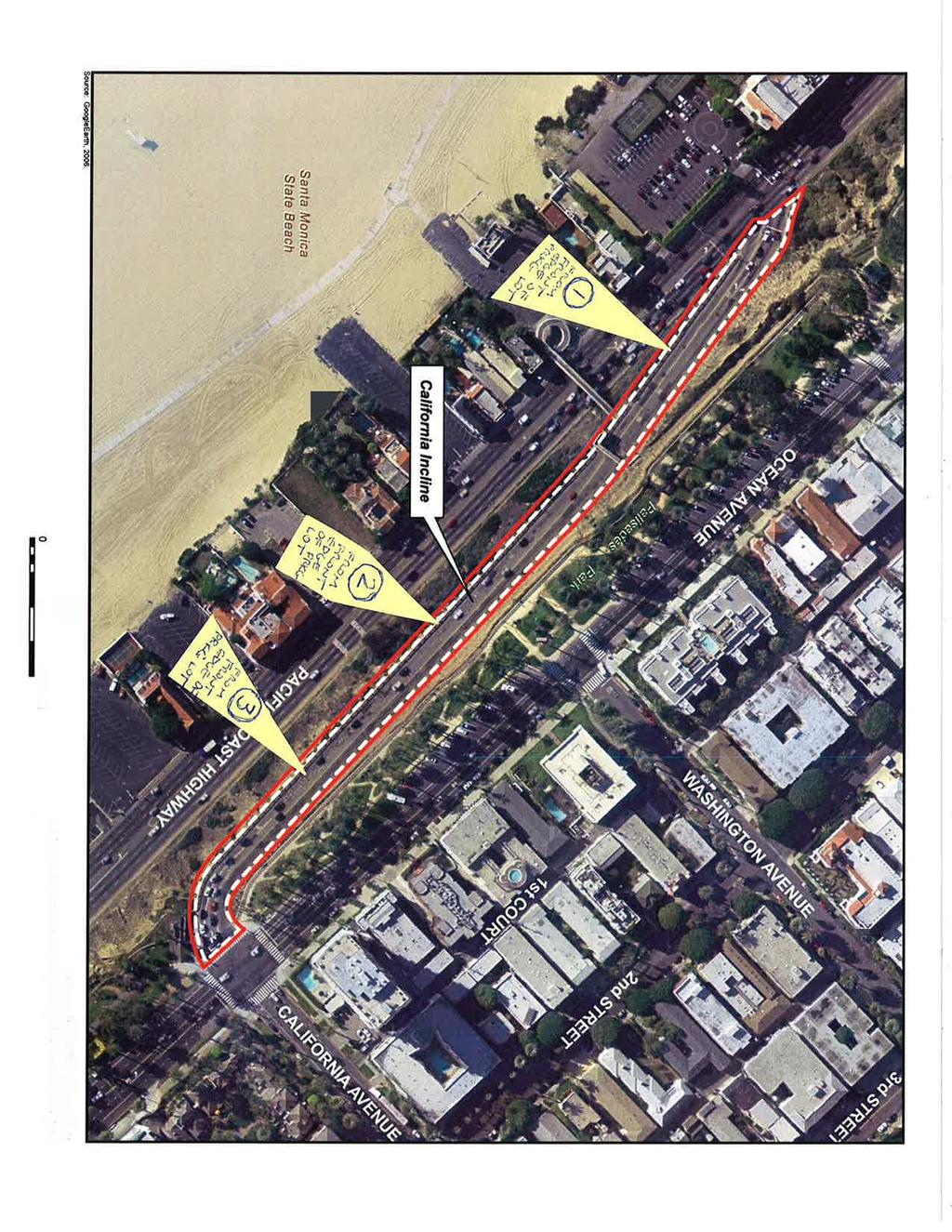
22 When analyzing the effects of a project on visual quality, the key tasks include describing the visual setting, identifying the existing visual resources and assessing viewer response to them, depicting the visual appearance of project alternatives, assessing potential changes to visual resources and the probable viewer response to those changes, assessing the visual impacts of project alternatives, and proposing methods to mitigate adverse visual impacts. The project s degree of consistency with existing visual character and whether the project as proposed would obstruct significant views are the basic criteria derived from the FHWA guidelines for assessing the level of impact/effect. Effects or impacts are further characterized by their potential levels of significance, as follows: Low Project would result in a minor adverse change related to visual resources or the visual environment, with low viewer response to that change. Typically, no mitigation would be required; Moderate Project would result in a moderate degree of adverse change related to visual resources or the visual environment, with a moderate level of response to that change. Adverse project effects/impacts would be mitigated within 5 years using conventional practices; and High Project would result in a high level of adverse change related to visual resources or the visual environment, to such a degree that architectural design and landscape treatment may or may not mitigate the impacts/effects. The viewer response level would be high, and major mitigation measures would be required to address the effects, potentially necessitating an alternative project design approach. The change in visual quality compares the existing condition (represented by a visual quality score) to the proposed condition (also represented by a visual quality score). This change is expressed as a negative number (adverse effect) or a positive number (positive effect). The proposed and existing visual quality scores are compared to determine the extent of change, positive or negative. Using this information, a determination is made regarding whether the project would result in a potentially adverse effect under NEPA and/or a potentially significant impact under CEQA. Proposed Visual Quality Score Existing Visual Quality Score = Visual Quality Change Public Input Regarding Key Visual Resources Nearby residents have indicated that they consider not only Palisades Park and the California Incline to be significant visual resources but, in addition, the bluffs adjoining the California Incline to be an equally significant visual resource as well. This level of concern about the bluffs suggests a high level of sensitivity to any project actions that would noticeably and adversely change the appearance of the bluffs. Analysis of Key Observation Points Expected effects on views to and from the incline were analyzed for each of the build alternatives, including all of the design options for the replacement alternative. Four key observation points (KOPs) were selected for this project given the existing visual quality and character, viewer groups/sensitivity, and whether visual resources were present in the views (KOP locations are shown in Figure 6). California Incline Bridge Replacement Project page 18
23 Figure 6: Key Observation Points California Incline Bridge Replacement Project page 19
24 KOP 1 (Photo 1) Bluff-side view within Palisades Park, near California Avenue, looking north. KOP 2 (Photo 4) View looking north along the east side of Ocean Avenue at Wilshire Boulevard KOP 3 (Photo 5) View of the bluffs, ocean, beach, and residences on SR-1from the incline looking north. KOP 4 (Figure 6) Views of Palisades Park, the upper bluffs, the incline, and the lower bluffs, from the west side of SR-1, looking east. Existing visual quality was analyzed at each KOP (see Table 1). As explained above, visual quality is determined by averaging scores for vividness, intactness, and unity. Table 1. Existing Visual Quality at Key Observation Points Vividness Intactness Unity Average (V+I+U)/3 Visual Quality KOP High KOP High KOP High KOP High KOP 1 Bluff-side view within Palisades Park, near California Avenue, looking north Photo 1 shows the current conditions at KOP 1 from a bluff-side vantage point (looking north within Palisades Park, near the intersection of California and Ocean Avenues at the top of the incline). Views at this location are highly vivid and include the park s landscaping, the distinctive balustrading, and the bluff and Pacific Ocean to the west. As shown in Table 1, existing visual quality is high. Viewers at this location would include recreationists and sightseers. Such viewers are considered sensitive. However, with the exception of those at the uppermost portion of the incline, viewers would have very constrained views to the project due to obstructed sightlines and topographic constraints. The key view when facing west is of the Pacific Ocean, the feature that dominates most bluff-side views from the park. Only the most determined viewers, when looking directly downward from the bluff s edge, would see any portion of the project, either during construction or operation. Project Features at This Location The proposed project would begin just south of this location as an at-grade feature, and either retain the existing incline (No-build Alternative) or essentially replicate the incline s current design, siting, and location (build alternative Options 1 and 2). As at present, the incline would descend the bluffs and be out of view. California Incline Bridge Replacement Project page 20
25 Changes in Visual Resources at This Location Visual Character Consistency Because the proposed project calls for retention of the existing incline or replication in the same location, with design elements that would essentially match the existing design elements, the project would be fully consistent with the existing design character. Views The proposed project would not alter key views in any direction from within Palisades Park, nor would it alter views of the Pacific Ocean. Impacts The change in visual quality is shown in Table 2. Visual quality under the proposed project would not change because no significant views or visual resources would be affected by the project, and all key views within Palisades Park, including views of the ocean, would remain unchanged. Table 2. Visual Quality at Key Observation Points 1, 2, and 3 with the Proposed Project Vividness Intactness Unity Visual Quality Rating (V+I+U)/3 Visual Quality Visual Quality Rating with Proposed Project KOP High 5 KOP High 4.66 KOP High 4.66 KOP High 4 KOP 2 View looking north along the east side of Ocean Avenue at Wilshire Boulevard Photo 4 shows current conditions at KOP 2 from the east side of Ocean Avenue at Wilshire Boulevard. The view documents the presence of Palisades Park on the west (on the left in the photo) as well as the nature of development along the east side of Ocean Avenue, including the Miramar Hotel and low-rise and high-rise apartment buildings and condominiums, nearly all of which have highly valued ocean-facing and park-facing views. As with views from the park, views from this location are highly vivid and include the skyline along the east side of Ocean Avenue, with attractive, well-maintained apartment, condominium, and hotel development; parkway landscaping; as well as Palisades Park on the west side of the thoroughfare. As shown in Table 1, the existing visual quality is high. Viewers include motorists, residents, and pedestrian sightseers. Given that Ocean Avenue is a local scenic corridor, such viewers are considered sensitive. However, with the exception of the uppermost portion of the incline, these viewers would have very constrained views to the project due to obstructed sightlines and topography. California Incline Bridge Replacement Project page 21
26 Project Features at This Location The proposed project would begin one block north of this location as an at-grade feature, either retaining the existing incline (No-build Alternative) or essentially replicating the incline s current design, siting, and location (build alternative Options 1 and 2). As at present, the incline would descend the bluffs and be out of view. Changes in Visual Resources at This Location Visual Character Consistency Because the proposed project calls for retention and rehabilitation of the existing incline or replication in the same location, with design elements that would essentially match the existing design elements, the project would be fully consistent with the existing design character. Views The proposed project would not alter key views in any direction from Ocean Avenue, nor would it alter views now experienced by residents, motorists, and sightseers when looking at the park or toward the Pacific Ocean. Impacts The change in visual quality is shown in Table 2. Visual quality under the proposed project would not change because no significant views or visual resources would be affected by the project, and all key views along Ocean Avenue, including views of Palisades Park and the ocean, would remain unchanged. KOP 3 View of the bluffs, ocean, beach, and residences on SR-1 from the California Incline looking north Photo 5 shows current conditions at KOP 3 from a vantage point along the California Incline. The view documents the bluffs steep topography and the change in elevation that separates Palisades Park from SR-1 below. This drop in elevation from the park to SR-1 ranges from approximately 75 to 100 feet. The view also documents representative examples of the residential development occurring along the beachside of SR-1. As with views in the park and along Ocean Avenue, views at this location are highly vivid due in part to the dramatic topography/geological forms and the presence of the beach and the Pacific Ocean (in west-facing and occasional north-south views). As shown in Table 1, existing visual quality in this setting is high. Viewers include motorists, pedestrians, and recreationists on the incline. These viewers are considered sensitive. However, with the exception of those at the uppermost portion of the incline, these viewers would have very constrained views to the project due to obstructed sightlines and topographic constraints. Project Features at This Location The proposed project would begin as an at-grade feature, and either retain the existing incline (No-build Alternative) or essentially replicate the incline s current design, siting, and location (build alternative Options 1 and 2). As at present, the incline would descend the bluffs as a shelf-like extension in a diagonal line. California Incline Bridge Replacement Project page 22
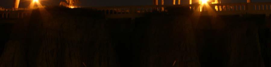
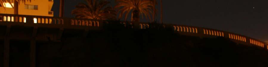
27 Changes in Visual Resources at This Location Visual Character Consistency With one exception, because the proposed project calls for retention and rehabilitation of the existing incline or replication in the same location, with design details that would essentially match the existing design elements, the project would be consistent with the existing design character. The only new element to the existing condition would be the installation of soil nails for geologic stability on the upper bluffs. However, the soil nails would be small (6 to 9 inches in diameter). They would be inserted into the upper bluff slope and would not extend out from the bluff soil surface. The soil nails would blend in with the surrounding bluff soil and vegetation; therefore, no adverse changes to the upper bluff slope would occur from the soil nails. Views The proposed project would not alter key views when looking in any direction from KOP 3. Views to the west of residences, the beach, and the ocean would remain unchanged. The soil nails on the upper bluffs would slightly change the look of the upper bluff slope for motorists, pedestrians, and recreationists but not substantially enough to adversely affect this view. Impacts As shown in Table 2, visual quality under the proposed project would not change because no significant views or visual resources would be adversely affected by the project, and all key views of the bluffs, ocean, beach, and residences along the incline would remain unchanged. KOP 4 View of Palisades Park, the upper bluffs, California Incline, and the lower bluffs from the west side of SR-1 looking east Figure 7 shows current conditions at KOP 4 from a vantage point west of SR-1, which is where the residences and the beach are located. The view documents the bluffs steep topography and the change in elevation that separates Palisade Park from SR-1 below. This drop in elevation from the park to SR-1 ranges from approximately 75 to 100 feet. The residences on the west side of SR-1 have east-facing views of the bluffs and discrete views of the incline, which appears as a shelf-like extension of the bluffs. It is identified chiefly by its distinctive arcaded concrete balustrade (which mirrors the grade of the incline s roadway). Views at this location are highly vivid due in part to the dramatic topography/geological forms of the bluffs, the palm trees and other vegetation at Palisades Park along the top of the bluff that contrast with the horizon, and the incline s steep diagonal grade between the upper and lower bluffs. As shown in Table 1, existing visual quality in this setting is high. Viewers include motorists on SR-1, residents, recreationists, and beachgoers. Given that SR-1 is a local scenic corridor, such viewers are considered sensitive. In addition, neighborhood residents have indicated that they consider the bluffs to be an extremely significant visual resource and have expressed a strong preference to avoiding changes to the appearance of the bluffs. The proposed project would begin as an at-grade feature, either retaining the existing incline (No-build Alternative) or essentially replicating the incline s current design, siting, and location (build alternative Options 1 and 2). As at present, the incline would descend the bluffs as a shelf-like extension in a diagonal line. California Incline Bridge Replacement Project page 23
28 Figure 7: Existing Condition Facing East from KOP 4 and Expected Simulation of Build Alternative California Incline Bridge Replacement Project page 24
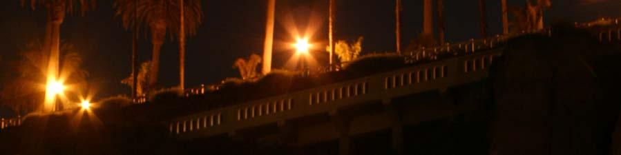
29 Changes in Visual Resources at This Location Figure 7 documents the current view west of SR-1 when facing the bluffs, which would essentially retain the visual elements of KOP 4under Build Alternative Option 1 and 2 (Figure 7). Visual Character Consistency The proposed project calls for retention of the existing incline or replication in the same location. For build alternative, Options 1 and 2, siting and the design details would essentially match the existing design elements of the incline and the surrounding bluff features. Installation of soil nails on the upper bluff slope would not change the appearance of the existing visual characteristics of KOP 4 substantially given the distance and elevation differential between the upper bluffs and KOP 4; however, nighttime lighting on the incline is being proposed for pedestrian and bicycling safety reasons, and would be built into the replicated incline balustrading to light the walkway/bicycle pathway with minimal spill light effects. Use of LED units producing low-intensity lighting would introduce an easily discernable diagonally-arrayed line of lighting (i.e., matching the descent of the incline roadway) into a portion of the bluffs area that currently is cast in nearly complete darkness at nighttime (existing conditions photos of nighttime views from KOP 4 are included in Appendix C). Therefore, the build alternative, Options 1 and 2, would be largely but not fully consistent with the existing design character. Views The proposed project under build alternative, Options 1 and 2 would not substantially alter key daytime views currently experienced by residents, motorists, recreationists, and beachgoers when looking at the bluffs or those who use SR-1. However, in east-facing views, a diagonally-arrayed line of lighting would be introduced into nighttime views of the bluffs an area that is, at present, cast in nearly-complete darkness at nighttime (see Appendix C). The introduction of more lighting would diminish a sense of the bluffs as a natural geologic feature that has been minimally impacted by human changes up to the present. Impacts As shown in Table 3, visual quality under the proposed project would change under the build alternative, or the No-build Alternative. Although no significant views or visual resources would be affected by the project and all key daytime views of the bluffs and of the incline would remain unchanged, balustrade lighting on the incline would change nighttime views which are currently cast in nearly-complete darkness. Therefore, the visual quality rating for the site under the build alternative and the No-build Alternative would be reduced slightly from high to moderately-high. Table 3. Visual Quality at Key Observation Point 4 with the Proposed Project Vividness Intactness Unity Visual Quality Rating (V+I+U)/3 Visual Quality Build Alternative Moderately High No-Build Alternative Moderately High Visual Quality Rating (Proposed Project) 4 5 California Incline Bridge Replacement Project page 25
30 Construction Impacts A moderate amount of excavation and smoothing would be required on the lower bluff slope as part of the project, including pile driving and soil nailing, construction of a temporary access road, removal of the existing sidehill viaduct structure, and the erection of temporary falsework columns and beams under the build alternative. In addition, construction staging/stockpiling, the storage of road-building materials, the presence of construction equipment, and temporary traffic barricades would result in minor temporary potential visual impacts. The visible activities would include the removal and installation of pavement, the erecting of falsework, other routine construction activities, and deliveries by truck. These activities would be visible to the motorists and sightseers travelling on SR-1, beachgoers travelling between Palisades Park and the beach via the existing pedestrian overcrossing, and those in the adjacent residential properties along SR-1 with sightlines to the bottommost portion of the incline at SR-1. Views of these activities would not be easily acquired from Palisades Park or Ocean Avenue residents. The sensitivity of residents is expected to range from low to moderate according to the sightlines. For the small number of residents who live along the west side of SR-1, near the bottommost portion of the incline, sensitivity would be greatest; however, most construction activities would be only minimally visible to other residents (e.g., those SR-1 residents who are more than a few hundred feet north or south of the base of the incline) due to topographic factors and/or the intervening distances that separate the viewer from the construction site. Due to heavy traffic along SR-1, including high levels of traffic-related noise, the residents who are closest to the construction activities on SR-1 are likely to have a moderately high tolerance level for the minor construction-related impacts on the visual setting; their sensitivity is therefore considered moderate. Motorists (including sightseers in vehicles) traveling along Ocean Avenue would see barricades at the uppermost portion of the incline during the construction process; however, due to the slope of the incline, they would see only a small portion of the construction process (viz., the presence of construction equipment and some building activities) as they drive through the project area. Given the brief opportunity to acquire views of the construction process from Ocean Avenue, motorists are likely to have a moderate tolerance level for minor construction-related effects/impacts; their sensitivity is therefore considered moderate. In addition, the construction activities would be temporary, and once the improvements are complete, the roadways would essentially look and function as they did previously. Construction-related impacts during the construction process would include the following: excavating the soil for shallow footings and drill holes for CIDH piles; drilling holes and installing soil nails in the lower bluff slope; reinforcing the footings and CIDH piles and pouring concrete; installing temporary falsework footings and erecting temporary columns and beams; constructing a retaining wall and north end curb, gutter, sidewalk, and barrier; reconstructing and restriping the roadway; removing the falsework and temporary footings; removing the temporary access road and regrading/revegetating the disturbed slope. All actions called for under the Build Alternative options would be temporary, however, and the changes to the bluff and bluff landscape would be reversible. Once the construction process is completed, these would have no significantly noticeable long-term effect on the visual surroundings because the incline California Incline Bridge Replacement Project page 26
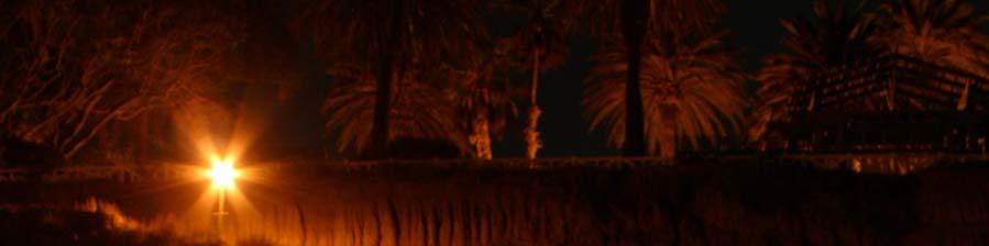
31 would retain the same location, siting, and design elements it currently has. Therefore, substantial adverse effects under NEPA or significant impacts under CEQA due to construction activities are not anticipated under the Build Alternative or the No-build Alternative. Operational (Long-Term) Impacts The project is located in an area of high natural beauty and is frequented by residents and visitors alike. The City of Santa Monica General Plan and the City of Santa Monica Local Coastal Plan stipulate that views of Palisades Park, the Pacific Ocean, and the Santa Monica beach are to be protected. Under the build alternative Options1and 2, or the No-Build Alternative, no changes are proposed as part of the project that would disrupt scenic vistas, remove or destroy character-defining features such as landscape or hardscape features in Palisades Park, or the bluffs significant geologic character. In addition, views from Ocean Avenue and SR-1 would be preserved. The incline would either be retained as is(no Build- Alternative) or replaced in kind at the same location as the existing incline (build alternative, Options 1 and 2), with design features of the existing incline replicated. Therefore, under the build alternative, once construction is completed, the incline would look and function as it does at present. Shade/Shadow and Light/Glare Impacts At present, no lighting is incorporated as part of the incline, and its current features do not generate glare. Because the design and placement of the incline either would be retained as is or replicated, no materials or finishes are proposed that would generate glare. It is anticipated that minimally detectable glare generated by vehicle headlights would remain at existing levels. This would not be experienced by sensitive viewers as a change from existing conditions, nearly all of whom have highly constrained sightlines to the project. Because of this, direct glare impacts are not anticipated and any incidental impacts would be less than significant under CEQA and not substantially adverse under NEPA. Impacts due to shade/shadow are not anticipated as a result of the project. The incline reads as a shelflike projection from the bluffs and tends to recede into the adjoining wall-like backdrop. Current incline features do not cast shadows/shade on adjacent residential properties due to its siting. Because the proposed project would retain the existing incline or, under the build alternative, essentially replicate it at the same location, it would not increase the height of the incline s roadway elements. It poses no potential to create new shade/shadow impacts for shade/shadow-sensitive viewers. Consequently, adverse effects under NEPA and significant impacts under CEQA due to shade/shadow would not occur. As proposed under build alternative Options 1 and 2, key daytime views currently experienced by residents, motorists, recreationists, and beachgoers along SR-1 would not be substantially altered when looking at the bluffs. For nighttime safety reasons, the proposed project includes low-intensity LED lighting that would be incorporated into the incline s new, replicated concrete balustrading. The lighting would produce an illuminance of 0.75 foot-candles and would result in minor spillover/light emanation effects upon eastfacing views from SR-1. In such east-facing views, a diagonally-arrayed line of lighting mirroring the downward-trending line of the roadway would be introduced into nighttime views of the bluffs an area that is, at present, cast in nearly-complete darkness at nighttime as evidenced by photographs of the conditions included in Appendix C. The introduction of more lighting would diminish a sense of the bluffs as a natural geologic feature that has been minimally impacted by human changes and man-made design elements up to the present. California Incline Bridge Replacement Project page 27
32 Cumulative Impacts The area of effect for cumulative visual effects would extend along the entire length of Palisades Park from the city s northern corporate boundaries south to Colorado Avenue. The area is bounded by Ocean Avenue on the east and the beachside development abutting SR-1 on the west. There are no other known projects within the area of cumulative effect. Existing visual quality within the area of effect ranges from moderate to high. Although demolition and replacement of the incline is proposed under the build alternative, the California Incline s current design, siting, and location would essentially be replicated. As a result, the design qualities that make the incline a significant visual resource would be preserved. Under the No-Build Alternative, the incline would be retained as is, and no noticeable changes in its design character/quality would occur. Under the build alternative, Options 1 and 2, and the No-Build Alternative, no significant changes to the surrounding bluffs would occur as a result of the project. While there may be the potential for nighttime construction that would require lighting, the lighting would be directed down at the work surface and away from any potentially sensitive receptors such as residences. Also, such lighting would be temporary in nature, ceasing once the construction process is completed. The project would include no lighting components or materials during operation that would increase glare, and thus, would not contribute to an increase nighttime glare levels within the area of cumulative effect; hence, the project would be neither individually adverse/significant nor cumulatively significant with respect to its effect on daytime or nighttime glare. Moreover, no shade/shadowproducing features are proposed as part of the project; therefore, no effect on shade/shadow-sensitive receivers would occur. As proposed under build alternative Options 1 and 2, key daytime views currently experienced by residents, motorists, recreationists, and beachgoers along SR-1 would not be substantially altered when looking at the bluffs. Nighttime views, however, would be somewhat changed due to the introduction of the proposed incline balustrade lighting. That is because the bluffs, at present, are cast in nearly-complete darkness at nighttime as evidenced in photos included in Appendix C, the lighting would be along a diagonal line, and the sense of the bluffs as a cherished natural geologic feature that has been minimally impacted by human changes and man-made design elements up to the present would be diminished. The resulting light spillover/light emanation effects would, nonetheless, be considered less than significant after the City s enhanced design/operational standards are factored in with installation of the lighting. As no other projects are proposed calling for new lighting features along the bluffs within the area of effect, the proposed project would not result in effects on visual resources that are cumulatively significant. In summary, with respect to visual resources, light/glare, and shade/shadow, no adverse constructionrelated or operational cumulative effects under NEPA or significant impacts under CEQA are anticipated under build alternative, Options 1 and 2, or the No-Build Alternative. Avoidance, Minimization, and Mitigation Measures There is some potential during the construction process for light-related effects/impacts to occur on a short-term basis were the city to carry out construction on a 24-hour-a-day basis. Such impacts would be very limited, however, potentially affecting only a small number of residents along SR-1. The normally darkened bluffs would be illuminated over the course of a 3- to 4-month period. Due to the intervening California Incline Bridge Replacement Project page 28
33 distances and topography, the effect of this temporary lighting would be minimized. Furthermore, as a best management strategy, any construction-related nighttime lighting would be directed onto the roadway of the incline and shielded to prevent glare impacts on SR-1 residents. Under the build alternative, Options 1 and 2, and No-Build Alternative the project would not have a significant/adverse effect on daytime views of visual resources. However, the build alternative would result in a minor adverse change to the visual characteristics of the bluffs adjoining the California Incline in east-facing nighttime views from SR-1, due to the introduction of lighting in an area that is largely cast in darkness at night and has been minimally impacted by human changes. The resulting light spillover/light emanation effects would, nonetheless, be considered less than significant after the City s enhanced design standards are factored in to minimize the amount of light output, so only the amount of light necessary for safety on the incline is used. Conclusion Replacement of the incline, as is proposed under the build alternative, Options 1 and 2, with a new incline that is similar in size, scale, and design to the existing structure and replicates the character-defining design elements would not result in a significant visual impact/substantially adverse effect because the project is proposed for the same location as the existing incline. All other visual elements that define the visual setting within Palisades Park, including the mature landscape and hardscape features on the bluff, would not change. In addition, existing views of Palisades Park and its bluffs, the Pacific Ocean, and SR-1 and Ocean Avenue would remain essentially unchanged. The retention of the existing incline, as is proposed under the No-Build Alternative, would not result in a significant impact/substantially adverse effect on visual resources. That is because the incline s character-defining design elements would be retained as is, and nearly all other visual elements defining the visual setting (e.g., within Palisades Park and along the bluffs) would not change. As a result, the visual quality of the incline and its visual setting would not differ from the existing conditions. Although nighttime lighting may be proposed during construction for a maximum of 3 to 4 months, its effects would be minimal due to sightline and topographic constraints. Such lighting impacts would be minimized through best management practices, such as directing all such lighting directly on the incline roadway and placing shielding devices on lighting to prevent glare impacts. In addition, the project has no potential to produce significant/substantial shade or shadows that could adversely affect shade- or shadow-sensitive viewers. Similarly, the incorporation of nighttime lighting as part of the incline would have a less than significant impact/no substantially adverse effect on nighttime views after the City s enhanced design/operational standards are implemented. Therefore, as a result, no significant impacts/no substantially adverse effects on visual resources, important views within the visual setting, or views of the incline and the adjoining areas are anticipated. California Incline Bridge Replacement Project page 29
34 Appendix A Bibliographic References City of Santa Monica Scenic Corridors Element, Santa Monica General Plan. City of Santa Monica The Local Coastal Plan, City of Santa Monica. City of Santa Monica Land Use Element, Santa Monica General Plan. City of Santa Monica Parks and Recreation Master Plan. March. City of Santa Monica Historic Resources Evaluation Report for the Properties in the Beach Improvement Group. Federal Highway Administration Visual Impact Assessment for Highway Projects. Washington, DC: Office of Environmental Policy. March.
35 Appendix B List of Preparers Mario Anaya, Environmental Planner. B.A., Global Studies, University of California, Los Angeles. Mr. Anaya has 2 years of experience in environmental planning with a focus on preparing CEQA and NEPA environmental documents, including initial studies/environmental assessments, negative declarations/fonsis, EIRs/EISs, and environmental noise measurement and analysis. Carson Anderson, Architectural Historian/Environmental Planner. M.A., Architectural History, University of Virginia; B.A., Architecture, College of Environmental Design, University of California, Berkeley. Mr. Anderson has more than 20 years of experience in community design and planning, CEQA/NEPA environmental analysis, visual impact evaluation, architectural history-related research and writing, and historic preservation planning. Shilpa Trisal, AICP, Project Manager, Senior Environmental Planner. M.A., Community Planning, University of Cincinnati; B.A., Planning, School of Planning and Architecture, New Delhi, India. Ms. Trisal has 7 years experience in environmental planning, with a focus on framework plan/master plan formulation, visual analysis, and socio-demographic research and writing.
36 Appendix C Existing KOP 4 Nighttime Conditions Photos
37


38 Vantage 1
39 Vantage 1
40 Vantage 1
41 Vantage 2
42 Vantage 2


43 Vantage 2


44 Vantage 2


45 Vantage 2
46 Vantage 2


47 Vantage 3
48 Vantage 3


49 Vantage 3


50 Vantage 3


51 Vantage 3
Nob Hill Pipeline Improvements Project EIR
 Section 3.1 Aesthetics This section addresses the visual aspects that may affect the views experienced by the public, including the potential to impact the existing character of each area that comprises
4.0 AFFECTED ENVIRONMENT AND ENVIRONMENTAL CONSEQUENCES
 4.0 AFFECTED ENVIRONMENT AND ENVIRONMENTAL CONSEQUENCES The following sections discuss the impacts associated with environmental resources for the tunneling method Alternatives A and B. The construction
Visual and Aesthetics
 Such a connection could accommodate timed transfers and improve connections between local transit service and Presidio Shuttle service. Level of Service The results of the analysis are provided on a route-by-route
5.8 Visual Resources and Aesthetic Qualities
 I-70 East Supplemental Draft EIS 5.8 Visual Resources and Aesthetic Qualities 5.8 Visual Resources and Aesthetic Qualities This section discusses the visual resources and aesthetic qualities of the study
3.1 AESTHETICS Background and Methodology
 3.1 AESTHETICS 3.1.1 Background and Methodology 3.1.1.1 Regulatory Context The California Environmental Quality Act (CEQA) requires that project sponsors evaluate the project s potential to cause aesthetic
Environmental Setting, Impacts, and Mitigation Measures
 CHAPTER 3 Environmental Setting, Impacts, and Mitigation Measures Format of the Environmental Analysis The assessment of each environmental resource discussed in this chapter includes the following: Environmental
IV.B. VISUAL RESOURCES
 IV.B. VISUAL RESOURCES ENVIRONMENTAL SETTING Existing Visual Character Project Site The project site is located at 17331-17333 Tramonto Drive in the Pacific Palisades community of the City of Los Angeles
4.1 AESTHETICS AND VISUAL QUALITY
 SCOPE AND METHODOLOGY 4.1 AESTHETICS AND VISUAL QUALITY This section evaluates the potential impacts to aesthetics and visual quality. Aesthetics refers to visual resources and the quality of what can
Section 3.16 Visual Quality
 Chapter 3 Affected Environment, Environmental Consequences, and Mitigation Measures Section 3.16 Visual Quality Introduction This section discusses existing conditions, effects and mitigation measures
3.10 LAND USE SETTING PROJECT SITE EXISTING LAND USE DESIGNATIONS AND ZONING. General Plan Land Use Designations.
 This section of the Draft EIR addresses the existing land uses on and adjacent to the project site and discusses the potential impacts of the proposed project on existing land uses. Key issues addressed
3.5 VISUAL AND AESTHETIC QUALITIES
 3.5 VISUAL AND AESTHETIC QUALITIES 3.5.1 Introduction to Analysis 3.5.1.1 Summary of Results The Preferred Alternative would represent a minimal change to the visual character of the existing rail corridor.
Visual Impact Assessment 830 Pratt Avenue St Helena, CA
 Visual Impact Assessment 830 Pratt Avenue St Helena, CA 1. Introduction The following aesthetic visual impact assessment has been prepared pursuant to the California Environmental Quality Act (CEQA). The
IV. ENVIRONMENTAL IMPACT ANALYSIS B. AESTHETICS 1. VIEWS
 IV. ENVIRONMENTAL IMPACT ANALYSIS B. AESTHETICS 1. VIEWS ENVIRONMENTAL SETTING Existing Visual Character Project Site The project site is located at 10250 Wilshire Boulevard in the Westwood community of
Section 4(f) De Minimis Memorandum for the Hickman Road over Tuolumne River Bridge Replacement Project (Bridge No. 38C 0004)
 De Minimis Memorandum for the Hickman Road over Tuolumne River Bridge Replacement Project (Bridge No. 38C 0004)") 11060 White Rock Road, Suite 200 Rancho Cordova, CA 95670 Phone: (916) 363 4210 Fax: (916) 363 4230 M e m o r a n d u m To: Julie Myrah, Branch Chief Date: May 5, 2017 California Department of Transportation
11060 White Rock Road, Suite 200 Rancho Cordova, CA 95670 Phone: (916) 363 4210 Fax: (916) 363 4230 M e m o r a n d u m To: Julie Myrah, Branch Chief Date: May 5, 2017 California Department of Transportation
3.1 Aesthetics, Light, and Glare
 3.1 3.1.1 Introduction This section describes the existing aesthetics, light, and glare setting and potential effects from project implementation on visual resources and the site and its surroundings.
APPENDIX D: Visual and Aesthetic Conditions for NCCU Station Refinement. Durham-Orange Light Rail Transit Project
 APPENDIX D: Visual and Aesthetic Conditions for NCCU Station Refinement Durham-Orange Light Rail Transit Project October 2016 1. Introduction The Combined FEIS/ROD summarizes the effects of the D-O LRT
CHAPTER 10 AESTHETICS
 CHAPTER 10 AESTHETICS CHAPTER 10 AESTHETICS This section identifies and evaluates key visual resources in the project area to determine the degree of visual impact that would be attributable to the project.
6.8 SCENIC HIGHWAYS Introduction
 6.8 SCENIC HIGHWAYS 6.8.1 Introduction The Scenic Highways Element is an optional General Plan element authorized by Section 65303 of the Government Code. The Scenic Highways Element is intended to establish
5.1 AESTHETICS AND VISUAL RESOURCES Physical Setting
 5.1 AESTHETICS AND VISUAL RESOURCES 5.1.1 Physical Setting Aesthetic values are an important aspect in establishing the identity, sense of place, and quality of life in a community. Natural features in
3.1 AESTHETICS AND VISUAL RESOURCES
 3.1 AESTHETICS AND VISUAL RESOURCES This section examines the potential for the proposed Project to create aesthetic and visual impacts as defined by the California Environmental Quality Act (CEQA) as
Planning Commission Report
 Planning Commission Report To: From: Subject: Planning Commission Meeting: January 6, 2016 Agenda Item: 8-B Planning Commission David Martin, Planning & Community Development Director Introduction to the
4.5 Visual and Aesthetic Resources
 4.5 Visual and Aesthetic Resources 4.5.1 Summary Table 4.5-1 shows how many homes would have reduced visual quality under each alternative. Measures like the ones suggested in Section 4.5.5, Potential
WESTSIDE SUBWAY EXTENSION PROJECT. Addendum to the Visual and Aesthetic Impacts Technical Report
 PROJECT to the Visual and Aesthetic Impacts Technical Report August 2011 Visual and Aesthetic Impacts Technical Report SUMMARY On October 28, 2010, the Metro Board selected the Westwood/VA Hospital Extension
CHAPTER 15 AESTHETICS. Setting. Introduction. Impacts and Mitigation Measures of the 2015 Plan Alternatives
 CHAPTER 15 AESTHETICS Introduction Setting Impacts and Mitigation Measures of the 2015 Plan Alternatives CHAPTER 15 AESTHETICS INTRODUCTION Public acceptance of a project may be strongly influenced by
IV. ENVIRONMENTAL IMPACT ANALYSIS B. AESTHETICS 1. SHADE/SHADOW
 IV. ENVIRONMENTAL IMPACT ANALYSIS B. AESTHETICS 1. SHADE/SHADOW ENVIRONMENTAL SETTING The issue of shade and shadow pertains to the blockage of direct sunlight by onsite buildings, which affect adjacent
Clay Street Bridge Replacement Project
 Clay Street Bridge Replacement Project Frequently Asked Questions (FAQs) No. 2 April 4, 2018 The project is located in downtown Placerville on Clay Street between US Highway 50 and Main Street and Cedar
2.1.8 Cultural Resources Regulatory Setting. Affected Environment, Environmental
 REVISED DRAFT ENVIRONMENTAL IMPACT REPORT/ Affected Environment, Environmental 2.1.8 Cultural Resources This section evaluates the potential for historical and archaeological resources within the proposed
4.1 AESTHETICS EXISTING ENVIRONMENTAL SETTING ALAMITOS BAY MARINA REHABILITATION PROJECT CITY OF LONG BEACH
 4.1 AESTHETICS This section provides a discussion of the existing visual and aesthetic resources on site and in the surrounding area as well as an analysis of potential impacts from implementation of the
Views from the Bridge
 Chapter 2 Views from the Bridge Alternative 2A would primarily have adverse visual impacts to views from the Bridge, with the exception of a strongly adverse visual impact from Viewpoint 11 (Car View East)
The impacts examined herein take into account two attributes of aesthetic values:
 IV. ENVIRONMENTAL IMPACT ANALYSIS This section addresses the potential impacts to views and aesthetics as a result of the proposed Project at the Project Site and the development scenarios analyzed for
7.5 Impacts on the Section 4(f) Properties
 Properties") constructive use, such as noise, air quality and visual impacts were also assessed. It was determined that this project would not introduce changes of an external nature that would affect the recreational
constructive use, such as noise, air quality and visual impacts were also assessed. It was determined that this project would not introduce changes of an external nature that would affect the recreational
Right-of-Way Acquisitions and Relocations Technical Memorandum
 Right-of-Way Acquisitions and Relocations Technical Memorandum Southeast Extension Project Lincoln Station to RidgeGate Parkway Prepared for: Federal Transit Administration Prepared by: Denver Regional
5.4.6 Cumulative Operational Impacts
 5.4.5.2 Visual Character Impacts The proposed project is located in greater downtown Los Angeles, which is a dynamic environment where new projects are constructed on an ongoing basis. Additional development
IV. ENVIRONMENTAL IMPACT ANALYSIS B. AESTHETICS 1. AESTHETICS/VIEWS
 IV. ENVIRONMENTAL IMPACT ANALYSIS B. AESTHETICS 1. AESTHETICS/VIEWS ENVIRONMENTAL SETTING Aesthetic impact assessment generally deals with the issue of contrast, or the degree to which elements of the
3.2 AESTHETICS/VISUAL QUALITY
 3.2 AESTHETICS/VISUAL QUALITY This section evaluates the potential impacts of the proposed project on the existing visual conditions within MTRP. Design features proposed to reduce or avoid adverse effects
4.1 Aesthetics Setting. a. Visual Character
 Environmental Impact Analysis Aesthetics 4.1 Aesthetics This section analyzes the proposed Specific Plan s impacts related to aesthetics, including the existing visual character of and scenic views in
22a. Existing Condition. 22b. Simulation of NE 20th Street Alternative (D3)
") Appendix F4.5 Visual Consistency and Key Observation Point Analyses EXHIBIT F4.5-22 Key Observation Point 22 (looking east along NE 20th Street) 22a. Existing Condition 22b. Simulation of NE 20th Street
Appendix F4.5 Visual Consistency and Key Observation Point Analyses EXHIBIT F4.5-22 Key Observation Point 22 (looking east along NE 20th Street) 22a. Existing Condition 22b. Simulation of NE 20th Street
Glenn Highway MP DSR. Landscape Narrative
 Glenn Highway MP 34-42 DSR Landscape Narrative Project Landscape Goals The Glenn Highway MP 34-42 Project extends through a variety of landscape types typical to the Matanuska-Susitna Valley. In general,
5. Environmental Analysis
 5.1 This section of the Draft Environmental Impact Report (DEIR) describes the existing landform and aesthetic character of the project area and discusses the potential impacts to the visual character
Draft Gaviota Coast Plan Chapter 7: Visual Resources
 Draft Gaviota Coast Plan Chapter 7: Visual Resources 11/28/2012 Long Range Planning Division Planning and Development Department County of Santa Barbara Page Intentionally Blank Cover Photo: Gaviota Morning
6.1 Aesthetics Introduction
 SECTION 6.0 ENVIRONMENTAL ANALYSIS 6.1 Aesthetics 6.1.1 Introduction The aesthetic quality of the proposed Project is determined by its visual character, consisting of elements such as natural and man-made
Policies and Code Intent Sections Related to Town Center
 Policies and Code Intent Sections Related to Town Center The Town Center Vision is scattered throughout the Comprehensive Plan, development code and the 1994 Town Center Plan. What follows are sections
Page. I. Introduction 1. II. Project Purpose and Need 2. IV. Description of Section 4(f) Property 2. V. Impacts to Section 4(f) property 3
 Property 2. V. Impacts to Section 4(f) property 3") Table of Contents Programmatic Section 4(f) Evaluation for use of a Historic Bridge Replacement of Route 30/130 Bridge over the Cooper River Structure No. 0405-153 City of Camden, Borough of Collingswood,
Table of Contents Programmatic Section 4(f) Evaluation for use of a Historic Bridge Replacement of Route 30/130 Bridge over the Cooper River Structure No. 0405-153 City of Camden, Borough of Collingswood,
RZC Public View Corridors and Gateways
 RZC 21.42 Public View Corridors and Gateways 21.42.010 Purpose 21.42.020 Scope and Authority 21.42.030 Administration 21.42.040 Gateways Design 21.42.050 Unidentified Public Views 21.42.060 Identification
IV. ENVIRONMENTAL IMPACT ANALYSIS
 IV. ENVIRONMENTAL IMPACT ANALYSIS IV. ENVIRONMENTAL IMPACT ANALYSIS A. AESTHETICS AND VIEWS 1. INTRODUCTION This section analyzes the potential impacts that could result from the proposed project with
-MENDOCINO COUNTY PLANNING AND BUILDING SERVICES- DIVISION II OF TITLE 20--COASTAL ZONING CODE
 CHAPTER 20.504 VISUAL RESOURCE AND SPECIAL TREATMENT AREAS Sec. 20.504.005 Applicability. Sec. 20.504.010 Purpose. Sec. 20.504.015 Highly Scenic Areas. Sec. 20.504.020 Special Communities and Neighborhoods.
DEIS Reasonable Alternatives Visual Impacts Assessment Technical Report
 DEIS Reasonable Alternatives Visual Impacts Assessment Technical Report SH 68 from I-2/US 83 to I-69C/US 281 CSJs: 3629-01-001, -002, -003 Hidalgo County, Texas Texas Department of Transportation Pharr
Community Workshop. City of Richmond. January 25, 2011 SF Bay Trail Connection - Castro St to Richmond-San Rafael Bridge
 Community Workshop City of Richmond 1 City of Richmond Lead Agency BPAC Richmond Community ABAG Design and Process Funding Partner Caltrans Environmental; Process Review Design Process State and Federal
HALF MOON BAY LOCAL COASTAL PROGRAM. d), JOHN M. St>NGER ASSOCIATES INC S.F.' CA EIOO VISUAL RESOURCES OVERLAY.
, JOHN M. St>NGER ASSOCIATES INC S.F.' CA EIOO VISUAL RESOURCES OVERLAY.") VISUAL RESOURCES OVERLAY Old Downtown Jl&& Scenic Hillsides Ocean Views from Highway 1 HALF MOON BAY LOCAL COASTAL PROGRAM d), JOHN M. St>NGER ASSOCIATES INC S.F.' CA. 94114 EIOO 217 CHAPTER 7: VISUAL
VISUAL RESOURCES OVERLAY Old Downtown Jl&& Scenic Hillsides Ocean Views from Highway 1 HALF MOON BAY LOCAL COASTAL PROGRAM d), JOHN M. St>NGER ASSOCIATES INC S.F.' CA. 94114 EIOO 217 CHAPTER 7: VISUAL
Gold Line Bus Rapid Transit Transit Oriented Development (BRTOD) Helmo Station Area Plan
 Helmo Station Area Plan") Appendix F Gold Line Bus Rapid Transit Transit Oriented Development (BRTOD) Helmo Station Area Plan Introduction and Purpose of the Plan The Gold Line Bus Rapid Transit facility is an eleven-mile dedicated
Appendix F Gold Line Bus Rapid Transit Transit Oriented Development (BRTOD) Helmo Station Area Plan Introduction and Purpose of the Plan The Gold Line Bus Rapid Transit facility is an eleven-mile dedicated
ENVIRONMENTAL IMPACT ANALYSIS
 IV. ENVIRONMENTAL IMPACT ANALYSIS A. AESTHETICS This section addresses the potential impacts to aesthetics and views that could result from the proposed project, including development of the Add Area,
VISUAL RESOURCES 1. INTRODUCTION 2. EXISTING CONDITIONS. a. Visual Character
 IV.A VISUAL RESOURCES 1. INTRODUCTION This section addresses the potential changes in visual character that would result from implementation of the proposed Wilshire and La Brea Project. Also evaluated
Village Specific Plan Visual Impact Assessment
 Village Specific Plan Visual Impact Assessment Prepared for: The City of Del Mar Planning and Community Development Department 1050 Camino del Mar Del Mar, CA 92014 Prepared by: KTU+A Planning and Landscape
Site Design (Table 2) Fact Sheet & Focus Questions:
 Fact Sheet & Focus Questions:") Site Design (Table 2) Fact Sheet & Focus Questions: BACKGROUND WHAT IS SITE DESIGN? Site design refers to the arrangement of buildings and open spaces on adjacent sites to maximize the shared benefits
Site Design (Table 2) Fact Sheet & Focus Questions: BACKGROUND WHAT IS SITE DESIGN? Site design refers to the arrangement of buildings and open spaces on adjacent sites to maximize the shared benefits
Venice Pumping Plant Dual Force Main Project Draft EIR
 City of Los Angeles 5.9 LAND USE PLANS 5.9.1 Environmental Setting Venice Pumping Plant Dual Force Main Project Draft EIR The Project lies within the bounds of Los Angeles County and the City of Los Angeles.
FINAL Visual Impact Assessment
 FINAL Visual Impact Assessment Cross Valley Connector East Project SANTA CLARITA, CALIFORNIA Prepared for: City of Santa Clarita 23920 W. Valencia Blvd., Suite 300 Santa Clarita, CA 91355 As Lead Agency
6.3 VISUAL RESOURCES. Landscape Character
 6.3 VISUAL RESOURCES 6.3.1 Affected Environment The DMR discussion is divided into two areas, DMR and Dillingham Trail, which would extend from SBMR to DMR. The ROI includes all areas within the line of
GLEN ROAD PEDESTRIAN BRIDGE ENVIRONMENTAL ASSESSMENT STUDY PUBLIC INFORMATION CENTRE #2 OCTOBER 24, 2017
 GLEN ROAD PEDESTRIAN BRIDGE ENVIRONMENTAL ASSESSMENT STUDY PUBLIC INFORMATION CENTRE #2 OCTOBER 24, 2017 Glen Road Pedestrian Bridge Class Environmental Assessment 1 WELCOME! Welcome to the second Public
IV. ENVIRONMENTAL IMPACT ANALYSIS B. AESTHETICS
 IV. ENVIRONMENTAL IMPACT ANALYSIS B. AESTHETICS INTRODUCTION This section evaluates the potential impacts of the Proposed Project on aesthetics, views and vistas, light and glare, and shade and shadows
3.6 VISUAL/AESTHETICS
 3.6 VISUAL/AESTHETICS The information in this section is based on the I-710 Corridor Project Visual Impact Assessment (VIA) (December 2011) and Urban Design and Aesthetics Toolbox Report (February 2012).
ARTICLE VI: SITE PLAN REVIEW
 Section 6.01 - Site Plan Review (All Districts) ARTICLE VI: SITE PLAN REVIEW Site plans give the Planning commission an opportunity to review development proposals in a concise and consistent manner. The
Section 6A 6A Purpose of the Natural Features and Landscapes Provisions
 Section 6A 6A Purpose of the Natural Features and Landscapes Provisions This Chapter addresses the protection and management of natural features and landscapes within the City. The City has a number of
The Illinois Department of Transportation and Lake County Division of Transportation. Route 173, including the Millburn Bypass
 The Illinois Department of Transportation and Lake County Division of Transportation welcome you to this Public Hearing for U.S. Route 45 from Illinois Route 132 to Illinois Route 173, including the Millburn
SECTION 5.1 Aesthetics, Light, and Glare
 SECTION 5.1 Aesthetics, Light, and Glare 5.1 AESTHETICS, LIGHT, AND GLARE Visual resources information for this section was compiled from photographs and site surveys conducted by RBF Consulting. The purpose
CITY OF LAGUNA BEACH COMMUNITY DEVELOPMENT DEPARTMENT STAFF REPORT DESIGN REVIEW BOARD IBOARD OF ADJUSTMENT Coast Highway APN
 CITY OF LAGUNA BEACH COMMUNITY DEVELOPMENT DEPARTMENT STAFF REPORT HEARING DATE: October 13,2011 TO: DESIGN REVIEW BOARD IBOARD OF ADJUSTMENT CASE: Variance 7717 Design Review 11-163 Coastal Development
A. WHAT IS A GENERAL PLAN?
 I. Introduction A. WHAT IS A GENERAL PLAN? A general plan is the planning guideline for the future of a city. It contains goals and policies which regulate urban development, the protection of the natural
DRAFT ENVIRONMENTAL IMPACT REPORT DEEP VALLEY DRIVE AND INDIAN PEAK ROAD MIXED-USE RESIDENTIAL PROJECT
 LSA ASSOCIATES, INC. JUNE 2012 SECTION 4.1 AESTHETICS DRAFT ENVIRONMENTAL IMPACT REPORT 4.1 AESTHETICS Introduction This section provides a discussion of the existing visual and aesthetic resources on
Mississippi Skyway Preliminary Engineering Report
 EXECUTIVE SUMMARY Mississippi Skyway Preliminary Engineering Report CITY OF RAMSEY, MINNESOTA DECEMBER 2014 City of RAMSEY EXECUTIVE SUMMARY Project Need and Intent The Mississippi Skyway pedestrian bridge
7.0 SOCIAL, ECONOMIC, AND ENVIRONMENTAL ISSUES
 7.0 SOCIAL, ECONOMIC, AND ENVIRONMENTAL ISSUES The following list of social, economic, and environmental issues have been identified based on a preliminary inventory of resources in the project area, an
STAFF REPORT FOR STANDARD COASTAL DEVELOPMENT PERMIT #CDP FEBRUARY 26, 2015 CPA - 1 PO BOX 238 APTOS, CA 94001
 STAFF REPORT FOR STANDARD COASTAL DEVELOPMENT PERMIT #CDP 2014-0030 FEBRUARY 26, 2015 CPA - 1 OWNER/APPLICANT: AGENT: REQUEST: HANS HEIM PO BOX 238 APTOS, CA 94001 JAMES HAY PO BOX 762 MENDOCINO, CA 95460
BRIDGE REHABILITATION ANALYSIS AND FEASIBILITY REPORT
 BRIDGE REHABILITATION ANALYSIS AND FEASIBILITY REPORT SR 0016-037 Main Street Bridge Project Memorial Bridge over the West Branch of Little Antietam Creek in Waynesboro Borough and Washington Township
Visual and Aesthetic Resources
 Visual and Aesthetic Resources 7.1 INTRODUCTION This chapter evaluates the effects of the Modified Design on visual and aesthetic resources, in comparison to the effects of 2004 FEIS Design. The 2004 FEIS
Los Angeles Department of City Planning RECOMMENDATION REPORT
 Los Angeles Department of City Planning RECOMMENDATION REPORT CULTURAL HERITAGE COMMISSION HEARING DATE: April 3, 2014 TIME: 10:00 AM PLACE: City Hall, Room 1010 200 N. Spring Street Los Angeles, CA 90012
112th Avenue Light Rail Options Concept Design Report JUNE 2010 PREPARED FOR PREPARED BY TBG PGH
 112th Avenue Light Rail Options Concept Design Report JUNE 2010 PREPARED FOR PREPARED BY TBG060310124909PGH C ontents Introduction 1 Project Overview 1 Public Involvement and Technical Coordination 4 Description
Bridge Type Assessment and Evaluation
 16M-01410-01 (3216026) Glen Road Pedestrian Bridge EA Study Bridge Type Assessment and Evaluation Factor Group/Criteria Alternative 1: Steel girder with two inclined steel legs Alternative 2: Steel girder
Town Center (part of the Comprehensive Plan)
") Town Center (part of the Comprehensive Plan) Mercer Island Town Center Looking North (2014) In 1994, a year-long process culminated in a set of design guidelines and code requirements for the Town Center
Town Center (part of the Comprehensive Plan) Mercer Island Town Center Looking North (2014) In 1994, a year-long process culminated in a set of design guidelines and code requirements for the Town Center
3.1 Aesthetics and Visual Resources
 3.1 This section discusses visual resources in the project area, the impacts on the visual resources that would result from the proposed project, and the mitigation measures that would reduce these impacts.
4.1 AESTHETICS/VISUAL RESOURCES
 4.1 AESTHETICS/VISUAL RESOURCES This section provides a discussion of the visual resources in and around the project site, with an emphasis on the visual character and scenic qualities of the Gaviota Coast
1. INTRODUCTION. a. Light. b. Glare
 IV.A.2 LIGHT & GLARE 1. INTRODUCTION This section describes the existing sources of nighttime illumination and glare on the Project site and in the surrounding area and evaluates potential changes resulting
Section 2.1 Human Environment
 Section 2.1 Human Environment CHAPTER 2 AFFECTED ENVIRONMENT, ENVIRONMENTAL CONSEQUENCES, AND AVOIDANCE, MINIMIZATION AND/OR MITIGATION MEASURES Chapter 2 evaluates potential effects on environmental
The analysis area for the scenic resource is the project area described in Chapter 1. Affected Environment/Existing Condition
 Chapter 3 - Scenic Resource SCENIC RESOURCES Introduction The Spotted Bear Ranger District is a destination point for outdoor recreation activities and offers a variety of recreation opportunities: driving
Appendix E Preliminary Location Hydraulic Study
 Appendix E Prepared for: State of Alaska Department of Transportation and Public Facilities Prepared by: HDR Alaska, Inc. 2525 C Street, Suite 305 Anchorage, Alaska 99503 February 2014 This page intentionally
Glenborough at Easton Land Use Master Plan
 Implementation 114 9.0 IMPLEMENTATION 9.1 OVERVIEW This chapter summarizes the administrative procedures necessary to implement the proposed land use plan, infrastructure improvements, development standards,
PROJECT SITE The Proposed Project includes the Allen and Pike Street malls between Delancey and South Streets (see Figure 2C-1).
.") Chapter 2, Section C: A. INTRODUCTION This chapter considers the potential of the proposed Reconstruction of the Allen and Pike Street Malls project to affect the urban design characteristics and visual
Chapter 2, Section C: A. INTRODUCTION This chapter considers the potential of the proposed Reconstruction of the Allen and Pike Street Malls project to affect the urban design characteristics and visual
STATE OF TENNESSEE DEPARTMENT OF TRANSPORTATION ENVIRONMENTAL DIVISION
 STATE OF TENNESSEE DEPARTMENT OF TRANSPORTATION ENVIRONMENTAL DIVISION Suite 900 - James K. Polk Building 505 Deaderick Street Nashville, Tennessee 37243-0334 MEMORANDUM TO: FROM: Files Joe W. Matlock,
7.0 SECTION 4(F) EVALUATION
 EVALUATION") Chapter 7 Section 4(f) Evaluation 7.0 SECTION 4(F) EVALUATION 7.1 Background Information and Regulatory Requirements This chapter presents the existing conditions and potential effects to parklands and
Chapter 7 Section 4(f) Evaluation 7.0 SECTION 4(F) EVALUATION 7.1 Background Information and Regulatory Requirements This chapter presents the existing conditions and potential effects to parklands and
A BILL FOR AN ORDINANCE TO AMEND CHAPTER 9, KAUAI COUNTY CODE 1987, RELATING TO STREET REQUIRE:MENTS FOR SUBDIVISIONS
 ORDINANCE NO. BILL NO. { vy"yj1j A BILL FOR AN ORDINANCE TO AMEND CHAPTER 9, KAUAI COUNTY CODE 1987, RELATING TO STREET REQUIRE:MENTS FOR SUBDIVISIONS BE IT ORDAINED BY THE COUNCIL OF THE COUNTY OF KAUA'I,
INTRODUCTION. 1.1 What is a General Plan? 1.2 Requirements for a General Plan. 1.3 Introduction to Monterey County
 1.1 What is a General Plan? INTRODUCTION California state law requires each city and county to adopt a comprehensive, long-term general plan for the physical development of the county or city, and any
Appendix G Response to Comments
 Appendix G Response to Comments This appendix contains the comments received during the public circulation and comment period (May 27, 2008 to July 11, 2008). The comments have been numbered (Comment Set
Chapter Master Planned Communities (MPC) District
 District") Sections 14.53.010 Purpose and Intent 14.53.020 Applicability 14.53.030 Procedure 14.53.040 MPC Standards 14.53.050 Required Findings 14.53.010 Purpose and Intent Chapter 14.53 Master Planned Communities
Sections 14.53.010 Purpose and Intent 14.53.020 Applicability 14.53.030 Procedure 14.53.040 MPC Standards 14.53.050 Required Findings 14.53.010 Purpose and Intent Chapter 14.53 Master Planned Communities
I. STAFF POLICY RECOMMENDATIONS. The following RMP policy strategies are proposed by staff in support of a Scenic Resource Protection Program:
 Policy Consideration: Scenic Resource Protection Program Status: For Consideration by the Highlands Council at September 14, 2006 Work session Date: September 12, 2006 I. STAFF POLICY RECOMMENDATIONS The
3.7 Aesthetics. A. Setting. 1. Existing Views of the Quarry
 3.7 Aesthetics A. Setting 1. Existing Views of the Quarry The existing quarry is visible from Highway 101 and from locations on the Ridgewood Ranch to the south. It is also possibly visible from distant
BROOKHILL NEIGHBORHOOD MODEL ZONING MAP AMENDMENT PREFACE TO APPLICATION
 BROOKHILL NEIGHBORHOOD MODEL ZONING MAP AMENDMENT PREFACE TO APPLICATION June 15, 2015 Revised: August 1, 2016 I. VISION Brookhill is a proposed community based upon the principles of Albemarle County
URBAN DESIGN GOALS / POLICIES / MEASURES
 URBAN DESIGN GOALS / POLICIES / MEASURES GOALS / POLICIES Authority Consideration of urban design issues in the general plan is provided under the Land Use Element requirements which direct attention to
A. INTRODUCTION B. NO ACTION ALTERNATIVE
 Chapter 19: Alternatives A. INTRODUCTION Over the years a variety of potential developments for the East River waterfront in Lower Manhattan have been considered. Some of these plans were very ambitious
AMEND DMENT H HOSPITAL
 AMEND DMENT TO LAND USE PLAN ELEMENT VILLAGE OF RIDGEWOOD MASTER PLAN H HOSPITAL ZONE DISTRICT Village of Ridgewood Planning Board February 28, 2014with technical revisions from June 9, 2014 Planning Board
The Anaheim Resort Public Realm Landscape Program. City of Anaheim. Adopted September 1994 (94R-239)
") Public Realm Landscape Program City of Anaheim Adopted September 1994 (94R-239) Amendment No. 1 October 1996 (96R-178) Amendment No. 2 June 1999 (99R-137) Amendment No. 3 February 2001 (2002R-56) Amendment
Public Realm Landscape Program City of Anaheim Adopted September 1994 (94R-239) Amendment No. 1 October 1996 (96R-178) Amendment No. 2 June 1999 (99R-137) Amendment No. 3 February 2001 (2002R-56) Amendment
4. INDUSTRIAL 53 CASTLE ROCK DESIGN
 4. INDUSTRIAL 53 CASTLE ROCK DESIGN CASTLE ROCK DESIGN 54 4. INDUSTRIAL Overview Well-designed and attractive industrial centers are the product of blending economic realities with both functional and
Project Purpose. Project Need
 Project Purpose The purpose of the project is to implement a bridge improvement solution that corrects the existing safety problem at the Strasburg Pike Bridge. The project will provide a structurally
GENERAL PLAN CONSISTENCY ANALYSIS
 GENERAL PLAN CONSISTENCY ANALYSIS Prepared by Planning Staff 10/28/2013 APPLICABLE GOALS, POLICIES AND PROGRAMS FROM the LAND USE CHAPTER Goal LU-1 Policy LU-1.1 Policy LU-1.2 Goal LU-2 Protect the character