KASPER. City of Georgetown, Texas PUD Planned Unit Development. December 30, 2015 Revised January 27, 2016
|
|
|
- Philomena Bradford
- 6 years ago
- Views:
Transcription
1 KASPER City of Georgetown, Texas PUD Planned Unit Development December 30, 2015 Revised January 27, 2016 Applicant: Sentinel Land Company, LLC 4910 Campus Drive Newport Beach, CA Prepared by: SEC Planning 4201 W. Parmer Lane Building A, Suite 220 Austin, Tx 78727
2 Exhibit A Kasper Planned Unit Development A. Purpose and Intent The Kasper PUD is composed of acres, as described in Exhibit B (Field Notes). The development of this property is planned as a high quality, residential community with multiple residential opportunities in a variety of lot sizes and configurations. The contents of this PUD further explain and illustrate the overall appearance and function desired for this community. A Concept Plan has been attached to this PUD, Exhibit C, to illustrate the design intent for the property. The Concept Plan is intended to serve as a guide to illustrate the general community vision and design concepts and is not intended to serve as a final document. The Concept Plan depicts a mix of residential products and open space areas which are contemplated within the community. B. Applicability and Base Zoning All aspects regarding the development of this PUD shall comply with the version of the Georgetown Unified Development Code (UDC) in effect at the date of PUD approval, except as established in this PUD exhibit, titled Exhibit A. For the purpose of complying with the UDC requirement of selecting a base zoning district, the following base district has been selected for the residential areas: RS Residential Single Family This PUD allows the definition of final lot boundaries during the platting process. All neighborhoods within the PUD will comply with the modified development standards of this PUD. In the case that this PUD does not address a specific City requirement, the Georgetown Unified Development Code shall apply. In the event of a conflict between this PUD and the base zoning district, this PUD shall control. C. Concept Plan Exhibit C attached is a conceptual development plan intended to visually convey the design intent for the Kasper community. The design of the community is not final, and is subject to refinement during the platting and site planning stages. This PUD zoning document does not constitute plat or site plan approval of the attached plan. The residential component of the project is comprised of a mix of various single family detached products. Additionally, Kasper will include a cohesive network of open spaces, including parks, greenbelts, water quality areas, trails, and a resident s amenity center. Kasper - Planned Unit Development Page 2 of 16
3 D. Allowable / Prohibited Uses The following uses within the Kasper PUD shall comply with the list of allowed and prohibited uses defined in the Georgetown UDC Chapter 5 Zoning Use Regulations. E. Lot Design Standards Residential Areas: Kasper will include a variety of detached residential product types and sizes. The residential areas shall be developed according to the following regulations: 50 and wider lot width Develop under Georgetown UDC regulations for RS Zero Lot line Develop under Georgetown UDC regulations for RS, Section C.3 The following unit count parameters and design standards have been established: Maximum Residential Units The requested residential total will not exceed 775 units. There shall be a minimum of 25% of the total units in each lot size (40s, 50s and 60s) and a maximum of 50% of the total units in any one lot size. Masonry Requirements: At least 85% of the exterior surface area of all street facing elevations shall consist of brick, stone or stucco. At least 85% of the exterior surface area of all side and rear elevations which are not facing a street shall consist of brick, stone, stucco, or cement based siding. Parking Requirement Every lot within Kasper shall provide a minimum of 2 parking spaces. The garage shall count as a minimum of one parking space as long as the garage is a minimum of 20 feet in depth, and as two spaces if the garage is more than 400 square feet. The driveway shall count as a minimum of one parking space as long as the driveway is a minimum of 20 feet deep, measured from the right of way line, so as to avoid an obstruction to the sidewalk within the right of way. Driveways For detached residential lots, Georgetown UDC Section c.3 shall be modified as follows: On local streets, no driveway is permitted closer to a corner than 40 for lots 50 and narrower. Measurement shall be taken from the edge of street pavement to the center of the driveway. Kasper - Planned Unit Development Page 3 of 16
4 Georgetown UDC Section D.5 shall be modified as follows: Driveway access to Single Family or Two Family dwelling units is permitted when spaced 50 feet apart measured center to center. Driveways shall be allowed along Residential or Major Collectors provided parking is limited to one side and the traffic speed limit along the Collector with proposed driveways shall not exceed 30 miles per hour. Georgetown UDC Section D.6 shall be modified as follows: collector streets no driveway is permitted closer to a corner than 50 feet. On Kasper - Planned Unit Development Page 4 of 16
5 The Kasper development will comply with the Development Standards set forth in Table E.1 Table E.1 Development Standards RESIDENTIAL USES Base District RS DETACHED 50 and wider lots See Base District RS DETACHED Narrower than 50 ft. lot no alley Impervious Cover 50%*** 50% Lot Width (minimum) 50 ft. 40 ft. Front Setback (minimum) 20 ft./ 15 ft* 20 ft. Side Setback (minimum) 0/5 ft.** 0/5 ft.** Corner Setback (minimum) 15 ft. 10 ft. Rear Setback (minimum) 10 ft. 10 ft. Building Height (maximum) 35 ft. 35 ft Lot Area (minimum) 5,500 s.f. 4,400 s.f. *Lots with side entry garage may reduce the front setback to 15. ** Setbacks shall be measured from the outside of the brick. Eaves and overhangs are permitted to encroach within the setbacks a maximum of 18 inches per Section C7. Zero lot line product is allowed when it follows Section C3 standards. ***Impervious cover shall be calculated over the entire Kasper subdivision gross site area, excluding the Kenney Fort Blvd. right of way. Individual lots within Kasper may contain up to 60% impervious cover as long as the entire subdivision remains at 50% or less of the gross site area. Tabulation of the impervious cover shall be noted and calculated during the platting stage and included on the plat for each neighborhood. Kasper - Planned Unit Development Page 5 of 16
6 F. Parkland/Trails/Open Space Open space within Kasper will create a network of trails and parkland that creates distinct neighborhoods and provides pedestrian walkways throughout the community. Per UDC Section , B, Formula for Calculating Area of Parkland, the acreage contributed for parkland shall be pro-rated in an amount equal to one acre for each 50 new detached single family dwelling units. As illustrated on Exhibit D, Open Space Summary, the Kasper PUD Concept Plan illustrates approximately 22.5 acres of public parkland/open space; a mix of greenbelts, open space, trail corridors, parks and water quality amenity lakes. The aforementioned open space shall fully satisfy the park land requirement for Kasper. Phase One of the development shall include the land area for a private amenity center as well as a minimum of five acres of parkland. The remaining parkland dedication will correspond with the adjacent subdivision construction phases. The Kasper community will include a private amenity center within the first phase land dedication that will be built as part of the second phase of the project. The amenity center will contain a resident s only swimming pool and pool building, as well as open public recreation facilities such as a public parking lot, playground, trail access, and an open play area. Each lot within Kasper will require a $250 parkland fee per the City of Georgetown fee schedule. The parkland improvement expenses within Kasper shall be allowed as credit toward the parkland fee requirement. Elements that can be used as credit shall include but not be limited to: Playgrounds Parking lots to serve parkland 8 hike and bike sidewalks Open recreation fields Public picnic pavilions Park site furnishings Turf and irrigation associated with play fields Amenity ponds and fountains Public restroom facility Pedestrian circulation will be a vital component of the Kasper community. The following summary describes the location and approximate linear footage of sidewalk proposed within Kasper: 5,500 linear feet of 8 wide sidewalk will be incorporated into a centralized open space greenbelt and will connect parks and neighborhoods. The sidewalk shall be constructed of concrete. Kasper - Planned Unit Development Page 6 of 16
7 4,200 linear feet of 8 wide, concrete bike and walking sidewalk will be located along the south and west side of Rockride Lane/Kenney Fort Blvd. Water quality ponds may be located along the greenbelt of Kasper and will be designed as an amenity feature that enhances the adjoining residential neighborhoods. All facilities utilized as credit toward parkland requirements shall be open to the public and shall be privately maintained by the Kasper MUD and/or homeowner s association. G. Roadway Design The Kasper vehicular circulation pattern provides access to all parts of the project from Rockride Lane, Future Kenney Fort Blvd. extension, and Westinghouse Road. See Exhibit C for roadway circulation and right of way classification. Roadway design standards shall be governed by the Georgetown UDC, Section 12.03, Streets unless modified within this PUD. The primary community entry will be from Rockride Lane at the southeastern area of Kasper, as illustrated on Exhibit C. The primary roadway will serve as the entrance for the residential areas of the community. The roadway may be median divided for a segment of the entry experience from Rockride to the amenity center park area and transition to a 65 Residential Collector or 73 Major Collector right of way with 30 of pavement, dependent on the TIA findings for right of way classification. Where the roadway is median divided, a minimum of 20 of pavement will be maintained on the inbound and outbound portions of the roadway. Other than as provided herein, the remainder of this roadway shall be designed to meet the UDC requirements for a residential collector. Right of way will be reserved for a 135 foot, arterial roadway corridor for the extension of Kenney Fort Blvd. through the project, as illustrated on Exhibit C. Kenney Fort Blvd. is a regional arterial that will provide a major circulation route for the eastern edges of Georgetown and Round Rock. To assist the municipalities and Williamson County in implementing this regional north/south roadway corridor, the Kasper development will dedicate the entire right of way for the arterial to be completed as a capital improvement project. The Kasper development will construct one half of the ultimate arterial roadway section, or construct the entire roadway as a Major Collector, within the boundary of Kasper. A Major Collector classification would accommodate all of the Kasper development traffic, as well as serve a significant amount of additional traffic that could be generated by future development in the immediate area. The City shall coordinate with the developer to determine which construction option is desired within the arterial roadway right of way. Dedication and improvement of Rockride Lane, the portion of the roadway bordering the subject property, shall be determined at the time a traffic impact analysis is completed. Internal local streets within Kasper shall utilize a 50 right of way with 28 of pavement measured from back of curb to back of curb. On street parking shall be restricted to one Kasper - Planned Unit Development Page 7 of 16
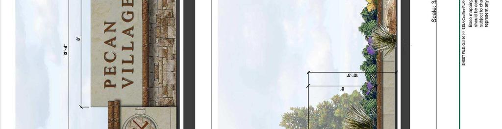
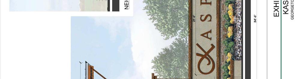
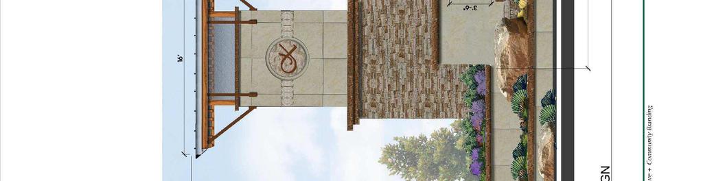
8 side of the street. A sign will be placed at entries into residential neighborhoods stating that parking is restricted to one (1) side of the street. The final sign language is to be determined and agreed to by the City and Applicant prior to installation. Roadway Landscaping: Along the extension of the Kenney Fort Boulevard arterial, landscaping shall be provided between the back of the lots and the right way in the following quantities: A minimum of 5 of landscape area will be provided between the right of way and the back of lots, with an average width of 10 2 shade trees, minimum of 3 inch caliper and 5 five gallon shrubs for every 1,000 square feet of landscape area located between the right of way and the back of lots Landscape in Right of Way: The Kasper PUD shall allow the planting of trees and vegetation within internal medians and public right-of-ways. The Developer or Homeowners Association is responsible for landscape maintenance and irrigation within the landscape lots and right of way. Landscape within the right of way shall require a license agreement with the City. If a median is planned within the ultimate build out section of the Kenney Fort Blvd. arterial, the City shall be responsible for landscaping, irrigation and maintenance within the median. H. Signage Exhibit E illustrates the location of signage within the Kasper community. Subdivision Entry Signs (see Exhibit F) Primary subdivision entry monument signs shall be located along Rockride Lane and the future extension of Kenney Fort Blvd., as illustrated on Exhibit E. A conceptual design for the freestanding monument signs is illustrated on Exhibit F. The sign scale and dimensions shall not exceed the dimensions illustrated on Exhibit F. Exhibit F shall replace the size restrictions described in Chapter 10 of the Unified Development Code. The signs shall be located a minimum of 20 from the right of way of Rockride Lane, Kenney Fort Blvd. and Westinghouse Road. A minimum of 1,000 s.f. of landscape plant bed shall be provided around each Subdivision Entry Sign. Plant material should be of a native and/or adapted species. Plants should be selected from the booklet titled, Native and Adapted Landscape Plants, an earthwise guide for Central Texas, 5 th Edition, 2013, created by the Texas Cooperative Extension, Grow Green and the Ladybird Johnson National Wildflower Center. Kasper - Planned Unit Development Page 8 of 16
9 Residential Neighborhood Monument Signs Neighborhood signs may be located throughout the community as noted on Exhibit E and illustrated on Exhibit F. The residential neighborhood signs shall not exceed the dimensions illustrated on Exhibit F for Neighborhood Entry Monuments. A minimum of 300 s.f. of landscape plant bed shall be provided around each Residential Neighborhood Monument Sign. Plant material should be of a native and/or adapted species. Plants should be selected from the booklet titled, Native and Adapted Landscape Plants, an earthwise guide for Central Texas, 5 th Edition, 2013, created by the Texas Cooperative Extension, Grow Green and the Ladybird Johnson National Wildflower Center. I. Fencing and Walls A masonry wall will be provided along the rear of all lots that back onto an unloaded collector or higher level roadway. The masonry wall shall consist of brick, stone or pre cast concrete fencing. All lots within Kasper which back onto open space or greenbelts shall be required to utilize a wrought iron view fence. J. Miscellaneous Provisions Amendments: Amendments to this PUD shall follow the amendment process outlined in the UDC Exhibits. All exhibits described herein and attached hereto are fully incorporated into this Agreement by this reference for all purposes. Kasper - Planned Unit Development Page 9 of 16


10 Exhibit B Field Notes Kasper - Planned Unit Development Page 10 of 16


11 Kasper - Planned Unit Development Page 11 of 16


12 Kasper - Planned Unit Development Page 12 of 16

13 Exhibit C Kasper - Planned Unit Development Page 13 of 16

14 Exhibit D Kasper - Planned Unit Development Page 14 of 16

15 Exhibit E Kasper - Planned Unit Development Page 15 of 16
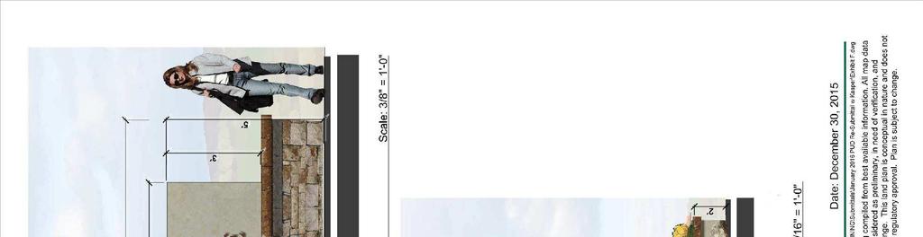


16 Exhibit F Conceptual Entry Monument Signs Kasper - Planned Unit Development Page 16 of 16
Three Forks Ranch. City of Georgetown, Texas PUD Planned Unit Development. January 11, West Braker Lane Suite 250 Austin, Texas 78759
 Three Forks Ranch City of Georgetown, Texas PUD Planned Unit Development January 11, 2007 Applicant: Waterstone Development 4314 West Braker Lane Suite 250 Austin, Texas 78759 Prepared by: SEC Planning
Design Guidelines for Residential Subdivisions
 Design Guidelines for Residential Subdivisions Development Services 972-466-3225 cityofcarrollton.com This page intentionally left blank. Table of Contents Purpose... 1 Design Objectives... 1 Design Guidelines
CITY PLANNING COMMISSION AGENDA ITEM: C STAFF: ROBERT TEGLER FILE NO: CPC PUD QUASI-JUDICIAL
 CPC AGENDA June 8, 2006 Page 37 CITY PLANNING COMMISSION AGENDA ITEM: C STAFF: ROBERT TEGLER FILE NO: CPC PUD 05-294 - QUASI-JUDICIAL PROJECT: APPLICANT: OWNER: PARKWOOD AT WOLF RANCH NASS DESIGN ASSOCIATES
Major Development Plan
 Major Development Plan Application number: MDP2016.03 Nixon Road Subdivision Request: The applicant request that the City Council receive the planning board recommendation to approve with conditions a
F. Driveways. Driveways which provide access to off-street parking or loading from public streets shall comply with the following:
 Section 20.945.040 General Design Standards for Surface Parking Areas. A. Review Authority. Parking lot design and drainage shall be subject to review and approval of the City Transportation Manager. B.
DESIGN AND LANDSCAPE GUIDELINES FOR DEVELOPMENT
 DESIGN AND LANDSCAPE GUIDELINES FOR DEVELOPMENT IN THE SECOND SUPERVISORIAL DISTRICT (REVISED) ADOPTED BY RIVERSIDE COUNTY BOARD OF SUPERVISORS ON SEPTEMBER 15, 1998 REVISED OCTOBER 23, 1998 REVISED AUGUST
RECREATION AND OPEN SPACE ELEMENT GOALS, OBJECTIVES, AND POLICIES
 RECREATION AND OPEN SPACE ELEMENT GOALS, OBJECTIVES, AND POLICIES Goal 7 To provide park facilities, recreation programs, and open space resources that are safe, adequate, and accessible to all City residents,
Landscaping Standards
 CHAPTER 29 ARTICLE 403 29.403 Landscaping Standards Purpose: The purpose of this section is to protect and promote the public health, safety and general welfare by requiring landscaping in relation to
ARTICLE IV: DEVELOPMENT STANDARDS 404 MASTER PLANNING
 IV 13 404 MASTER PLANNING Master Planning through the Site Analysis (Master Planning Site Analysis) or Planned Development (Master Planning Planned Development) is provided to encourage development which
Development Services Staff Report for Design Review Committee
 Development Services Staff Report for Design Review Committee To: Design Review Committee From: DS Staff: Erika Akin Subject: Proposed Addition to J s Car Wash File: DSRFY2016-1 Date: January 19, 2016
MIDTOWN MIXED-USE VILLAGE. TECHNICAL DATA SHEET COMPONENT C-1 FOR PUBLIC HEARING - PETITION NUMBER Project No RZ1.1. Issued.
 N MIDTOWN MIXED-USE VILLAGE TECHNICAL DATA SHEET COMPONENT C- FOR PUBLIC HEARING - PETITION NUMBER 04-00 Project No. 496 Issued Revised SCALE: " = 0' N 0 0 0 40 RZ. c GENERAL PROVISIONS: a. SITE LOCATION.
Baumgarten MPUD. Exhibit 3 Evaluation Criteria
 Pursuant to LDC subsections 10.02.13 B, 10.02.08 F and Chapter 3 G. of the Administrative Code, staff s analysis and recommendation to the Planning Commission, and the Planning Commission s recommendation
The subject site plan amendment proposes the following revisions to the approved site plan:
 PROPOSED AMENDMENT The subject site plan amendment proposes the following revisions to the approved site plan: 1. The building footprint was modified to accommodate the revised architectural design. 2.
 Villa Vizcaya PUD Amendment No. 3 4 April 16, 2008 May 29, 2015 Presented to: City of Port St. Lucie Planning and Zoning Department 121 SW Port St. Lucie Boulevard Port St. Lucie, Florida 34984 Exhibit
Rezoning Transportation Analysis Petition Number: General Location Identifier:
 From: Kelsie Anderson, PE Kelsie.Anderson@charlottenc.gov 704-432-5492 Staff Reviewer: Kory Hedrick, PE, PMP Khedrick@charlottenc.gov 704-432-6511 CDOT s review of this rezoning petition is intended to
M E M O R A N D U M. Consider a recommendation of a site plan for Sherwin Williams, a proposed approximately 4,500 square-foot paint store.
 M E M O R A N D U M Meeting Date: February 10, 2014 Item No. E- 8 To: From: Subject: Planning and Zoning Commission Cassie Harashe, Planner I Consider a recommendation of a Site Plan for Sherwin Williams,
BE IT ORDAINED by the Board of Supervisors of Chesterfield County:
 Attachment A AN ORDINANCE TO AMEND THE CODE OF THE COUNTY OF CHESTERFIELD, 1997, AS AMENDED, BY AMENDING AND REENACTING SECTIONS 19.1-52, 19.1-53, 19.1-236, 19.1-247, 19.1-253, 19.1-263, 19.1-341, 19.1-346,
EXHIBIT B PROJECT NARRATIVE POULSBO MEADOWS
 EXHIBIT B PROJECT NARRATIVE POULSBO MEADOWS Name of Project: Poulsbo Meadows; A Planned Residential Development (PRD)/Plat Applicants Name: PBH Group LLC/Byron Harris PO Box 1010 Silverdale, WA 98038 Description
ARTICLE 6: Special and Planned Development Districts
 ARTICLE 6: Special and Planned Development Districts 6-10 Traditional Neighborhood Development (TND) District 6-10.10 Purpose and Intent The Traditional Neighborhood Development (TND) District provides
D. Landscape Design. 1. Coverage Intent: To provide adequate landscaping materials that enhance the appearance of development projects.
 D. Landscape Design The standards and guidelines in this section give design guidance for the landscaping components of industrial and office projects. City regulations require that all landscaping be
Construction and Landscaping on Public Property
 Construction and Landscaping on Public Property City of Manhattan Beach Community Development Department 1400 Highland Avenue 310-802-5504 www.citymb.info January, 2004 Construction and Landscaping on
The Ritz-Carlton, Paradise Valley
 The Ritz-Carlton, Paradise Valley 7000 E. Lincoln Drive Keys to Success Community Conversation II June 4, 2015 RITZ-CARLTON PARADISE VALLEY Town Council Study Session June 4, 2015 General Plan 2012 Land
7.0 OPEN SPACE 7.1 OPEN SPACE DEDICATION CHAPTER 7: OPEN SPACE
 7.0 OPEN SPACE The intent of these requirements is to allow for the usage of centrally located unencumbered land as neighborhood open spaces and not to permit the use of leftover or otherwise unusable
Appendix L SH 360 OVERLAY DISTRICT. LAST UPDATE: December 10, 2013 CASE NUMBER: TA ORDINANCE NO
 Appendix L SH 360 OVERLAY DISTRICT LAST UPDATE: December 10, 2013 CASE NUMBER: TA131201 ORDINANCE NO. 9655 2013 Unified Development Code Grand Prairie, Texas Planning Department APPENDIX L: SH 360 OVERLAY
Chapter PEDESTRIAN COMMERCIAL (PC) ZONING DISTRICT
 ZONING DISTRICT") Chapter 11-17 PEDESTRIAN COMMERCIAL (PC) ZONING DISTRICT Sections: 11-17-01 GENERAL PURPOSE 11-17-02 PERMITTED BUILDING TYPES 11-17-03 USES PERMITTED WITH DESIGN REVIEW 11-17-04 USES PERMITTED BY CONDITIONAL
Chapter 11-17 PEDESTRIAN COMMERCIAL (PC) ZONING DISTRICT Sections: 11-17-01 GENERAL PURPOSE 11-17-02 PERMITTED BUILDING TYPES 11-17-03 USES PERMITTED WITH DESIGN REVIEW 11-17-04 USES PERMITTED BY CONDITIONAL
Gruene River Place PDD CONCEPT PLAN AND DEVELOPMENT STANDARDS
 Gruene River Place PDD CONCEPT PLAN AND DEVELOPMENT STANDARDS GRUENE RIVER PLACE PLANNED DEVELOPMENT DISTRICT As per Section 3.5, Chapter 144 of the City s Zoning Ordinance To: The Planning & Zoning Commission
CONCEPT BRIEF. 101 West Abram Street Arlington, Texas
 CONCEPT BRIEF 101 West Abram Street Arlington, Texas 76010 817-459-6502 www.arlingtontx.gov/planning PD13-18 Case Number: Form must be filled out completely. Please type or legibly print all information.
2 Project Description
 Project Description 2 Project Description The proposed project would involve the demolition of the existing church and the construction of 40 twostory single family residences. The residential lots would
CENTERS AND CORRIDORS
 INITIAL DESIGN STANDARDS AND GUIDELINES for CENTERS AND CORRIDORS City of Spokane Planning Services Third Floor, City Hall 808 W. Spokane Falls Blvd. Spokane, WA 99201-3329 (509) 625-6300 www.spokaneplanning.org
Chapter RM MULTI FAMILY BUILDING ZONES
 Chapter 19.17 RM MULTI FAMILY BUILDING ZONES 19.17.010 Established 19.17.020 Primary Permitted Uses 19.17.030 Accessory Permitted Uses 19.17.040 Secondary Permitted Uses 19.17.050 Conditional Property
Eastcreek Farm. Planned Development Standards September, 2014
 Eastcreek Farm Planned Development Standards September, 2014 ekfarm Contents 01. General Standards 02. Residential Development Standards 03. Architectural Design Standards 04. Landscape Design Standards
TOP TEN LIST OF COMMUNITY CONCERNS REGARDING PROPOSED AMENDMENTS TO CHAPTER 42
 TOP TEN LIST OF COMMUNITY CONCERNS REGARDING PROPOSED AMENDMENTS TO CHAPTER 42 1. Extend the urban area to Beltway 8 in stages, over say a three-year period, prioritizing development in transit and declining
4.500 Preston Road Overlay District
 Section 4.500 Preston Road Overlay District 2004 Zoning Ordinance 4.500 Preston Road Overlay District (ZC 98-29; Ordinance No. 98-9-12) 4.501 Purpose To provide appropriate design standards for the use
Neighborhood Districts
 NEIGHBORHOOD DISTRICTS SEVEN MAIN DISTRICTS Neighborhood Districts While the Development Plan provides a broad-scale overview of the neighborhood, this section focuses on uses and relationships at the
3.1 community vision. 3.3 required plan elements
 Chapter 3 Community Form 3.1 community vision 3.2 Parks & landscaping concepts 3.3 required plan elements D R A F T 20 Community Form Chapter 3 3.0 Community form 3.1 community vision The Specific Plan
Single-Family Detached Residential Design Guidelines
 Single-Family Detached Residential Design Guidelines Revised Oct. 2013 Single-Family Detached Residential Design Guidelines Table of Contents PURPOSE AND INTENT OF SINGLE-FAMILY DETACHED DESIGN GUIDELINES
BUILDING SCALE AND SETBACKS 5 ELEMENTS:... 5 FAÇADES (COMMERCIAL/RESIDENTIAL) 5
 5") VISION STATEMENT 3 UTILIZATION OF THE GUIDELINES 3 IMPLEMENTATION 3 PROCEDURES FOR DESIGN REVIEW 3 LAND USE AND ZONING 4 LAND USE 4 ELEMENTS:... 4 ZONING 4 ELEMENTS:... 4 BUILDING SCALE AND SETBACKS 5
VISION STATEMENT 3 UTILIZATION OF THE GUIDELINES 3 IMPLEMENTATION 3 PROCEDURES FOR DESIGN REVIEW 3 LAND USE AND ZONING 4 LAND USE 4 ELEMENTS:... 4 ZONING 4 ELEMENTS:... 4 BUILDING SCALE AND SETBACKS 5
SECTION 6 - LAND USE - RURAL RESIDENTIAL
 16.6.10.1 Intent The intent of the rural residential land use category is to provide low-density, single-family residential development within the Town s outer fringe. The current land is predominantly
ORDINANCE NO
 ORDINANCE NO. 2013-28 AN ORDINANCE AMENDING CHAPTER 98, ZONING, ARTICLE IV, OVERLAY DISTRICTS AND SPECIAL DISTRICTS OF THE CODE OF ORDINANCES OF WEST MELBOURNE, FLORIDA TO ESTABLISH DIVISION 5, MIXED USE
PRELIMINARY PLAT DESIGN REQUIREMENTS Updated 4/8/2016
 PRELIMINARY PLAT DESIGN REQUIREMENTS Updated 4/8/2016 The following items are required for the preliminary plat. Numbers correspond with those on the example preliminary plat. RENO COUNTY SUBDIVISION REQUIREMENTS
for Master Planned Development Framework Design Standards & Guidelines
 B L A C K D I A M O N D DE S I G N G U I D E L I N E S for Master Planned Development Framework Design Standards & Adopted June 18, 2009 Introduction and Purpose The Master Planned Development (MPD) Framework
GENERAL LANDSCAPE PROVISIONS. The following landscape provisions shall be adhered to by all land uses unless otherwise noted:
 CHAPTER 1.18 Sections: 1.18.005 Purpose. 1.18.010 Landscaping, Buffering, and Fencing Improvements Required. 1.18.015 General Landscape Provisions. 1.18.020 Landscaping Plan. 1.18.025 Single-Family Dwellings
City of Yelm. Tahoma Terra Final Master Plan Development Guidelines. Table of Contents
 City of Yelm Tahoma Terra Final Master Plan Development Guidelines Table of Contents Table of Contents... 1 Purpose... 2 Low Density Residential (R4-6)... 3 Moderate Density Residential (R6-10)... 5 Neighborhood
Eastcreek Farm. Planned Development Standards July, 2015
 Eastcreek Farm Planned Development Standards July, 2015 ek farm 01. General Standards 1.2 Applicability of Standards All regulations not specified in these Planned Development (PD) Standards for Eastcreek
Bylaw A Bylaw to amend Bylaw 12800, as amended, The Edmonton Zoning Bylaw Amendment No. 2239
 Bylaw 17672 A Bylaw to amend Bylaw 12800, as amended, The Edmonton Zoning Bylaw Amendment No. 2239 WHEREAS City Council at its meeting of February 22, 2001, gave third reading to Bylaw 12800, as amended;
Application Number: SD Project Name: Walton Farms Preliminary Subdivision (acting as Master Plan)
") STAFF REPORT Town of Clayton Planning Department 111 E. Second Street, Clayton, NC 27520 P.O. Box 879, Clayton, NC 27528 Phone: 919-553-5002 Fax: 919-553-1720 Planning Board May 22, 2017 Application Number:
STAFF REPORT Town of Clayton Planning Department 111 E. Second Street, Clayton, NC 27520 P.O. Box 879, Clayton, NC 27528 Phone: 919-553-5002 Fax: 919-553-1720 Planning Board May 22, 2017 Application Number:
Request Conditional Rezoning (R-15 Residential to Conditional A-24 Apartment) Staff Recommendation Approval. Staff Planner Jimmy McNamara
 Staff Recommendation Approval. Staff Planner Jimmy McNamara") Applicant Franklin Johnston Group Management & Development, LLC Property Owner Virginia Wesleyan College Public Hearing July 12, 2017 City Council Election District Bayside Agenda Item 3 Request Conditional
Applicant Franklin Johnston Group Management & Development, LLC Property Owner Virginia Wesleyan College Public Hearing July 12, 2017 City Council Election District Bayside Agenda Item 3 Request Conditional
City of Sheridan Landscape Plan Checklist
 Included? Section 1. Exemptions - Landscape Plan not Applicable (Sec. 56-512) 1. Single family dwellings, attached and detached, are exempt from landscape regulations and from providing landscape plans.
WASHINGTON COUNTY OREGON
 WASHINGTON COUNTY OREGON July 9, 2009 Revisions to Chapter 2 of the Bethany Community Plan The North Bethany Subarea Plan Exhibit pages 7 and 8 The sections for the Core and Flexible Streets were amended
Request Alternative Compliance to the prescribed criteria of the Oceanfront Resort District Form-Based Code. Staff Planner Kristine Gay
 Applicant/Owner Ocean Rental Properties, LLC Public Hearing April 13, 2016 City Council Election District Beach Agenda Item 1 Request Alternative Compliance to the prescribed criteria of the Oceanfront
2.5 Roads. Loading and service areas adjacent to Highway 401 should be screened through architectural walls and/or landscape buffer planting.
 N HIGHWAY OFF RAMP 2.5 Roads A legible road network with a clear hierarchy will help create a connected community, both within and surrounding the Milton Heights. The following section outlines the proposed
Article 7.05 Manufactured Home Park Districts
 Article Manufactured Home Park Districts.01 Intent The purpose of the MHP Manufactured Home Park District is to give recognition to the fact that manufactured homes can provide satisfactory living conditions
Single-Family Detached Residential Design Standards
 Single-Family Detached Residential Design Standards Revised Oct. 2013 Single-Family Detached Residential Design Guidelines Table of Contents PURPOSE AND INTENT OF SINGLE-FAMILY DETACHED DESIGN GUIDELINES
LANDSCAPE ORDINANCE PASADENA PLANNING DEPARTMENT (713) FAX (713)
 FAX (713)") LANDSCAPE ORDINANCE PASADENA PLANNING DEPARTMENT (713) 475-5543 FAX (713) 477-1072 ARTICLE X. LANDSCAPING OF NONRESIDENTIAL SITES* Sec. 9-195. Applicability. (a) This article shall apply to the following:
LANDSCAPE ORDINANCE PASADENA PLANNING DEPARTMENT (713) 475-5543 FAX (713) 477-1072 ARTICLE X. LANDSCAPING OF NONRESIDENTIAL SITES* Sec. 9-195. Applicability. (a) This article shall apply to the following:
STREETSCAPE MANUAL ONLINE TRAINING SESSION 1: Background
 TRAINING SESSION 1: The Urban Design Streetscape Manual is a reference tool developed to help implement City policy and guide the design, construction and maintenance of streetscape improvements in Toronto.
VILLAGES AT RIVERDALE
 VILLAGES AT RIVERDALE PD STANDARDS Case #Z 2016-005 Prepared For: Prepared By: Oakwood Homes, LLC Terracina Design 4908 Tower Rd 10200 E Girard Ave #A-314 Denver, CO 80249 Denver, CO 80231 (303) 486-8500
AWH REPORT OF THE PLANNING AND DEVELOPMENT DEPARTMENT FOR APPLICATION FOR REZONING ORDINANCE TO PLANNED UNIT DEVELOPMENT
 AWH REPORT OF THE PLANNING AND DEVELOPMENT DEPARTMENT FOR APPLICATION FOR REZONING ORDINANCE TO PLANNED UNIT DEVELOPMENT MAY 8, 2014 The Planning and Development Department hereby forwards to the Planning
North Oakville East Parks Facilities Distribution Plan. November, 2009
 North Oakville East November, 2009 POLICY CONTEXT 1) Purpose a) The purpose of this document is to be a guide for the location, configuration, design and development of the parks system for the North Oakville
EXHIBIT A. Chapter 2.7 SPECIAL PLANNED DISTRICTS. Article XVIII 15th Street School Master Planned Development
 EXHIBIT A Chapter 2.7 SPECIAL PLANNED DISTRICTS Article XVIII 15th Street School Master Planned Development Sections: 2.7.3600 15 th Street School Master Planned Development 2.7.3610 Purpose 2.7.3620 Definitions
VILLAGES AT RIVERDALE
 VILLAGES AT RIVERDALE PD STANDARDS Case #Z 2016-005 Prepared For: Prepared By: Oakwood Homes, LLC Terracina Design 4908 Tower Rd 10200 E Girard Ave #A-314 Denver, CO 80249 Denver, CO 80231 (303) 486-8500
Section 9 NEIGHBORHOOD DESIGN
 Section 9 NEIGHBORHOOD DESIGN City of Lancaster Comprehensive Plan D u n k i n, S e f k o & A s s o c i a t e s, I n c. NEIGHBORHOOD DESIGN INTRODUCTION There are many ways in which a neighborhood can
BOULEVARD AND PARKWAY STANDARDS
 88-323 BOULEVARD AND PARKWAY STANDARDS 88-323-01 PURPOSE Considerable public and private investment exists and is expected to occur adjacent to boulevards and parkways within the city. The following standards
PART 1: PROJECT SUMMARY. Proposed Land Use: 120 single-family lots. The application is Attachment A. The site plan is Attachment B.
 PART 1: PROJECT SUMMARY Applicant: JBH Development, LLC and Hopper Communities, INC Project Size: +/- 80.48 acres Parcel Number: 01513107, 01513108, 01513109, 01513113, 01513120, 01513121, 01513122, 01513124,
CHAPTER 530 SITE PLAN REVIEW
 ARTICLE I. GENERAL PROVISIONS CHAPTER 530 SITE PLAN REVIEW Community Planning and Economic Development Development Services Division 250 South 4 th Street, Room 300 Minneapolis MN 55415-1316 612-673-3000
A. Reducing noise pollution, air pollution, and visual pollution;
 A well designed landscape, when made an integral part of a development plan, provides aesthetic appeal and makes an important contribution to the health, safety, and general welfare of the community by:
Staff Report to the North Ogden City Planning Commission
 Staff Report to the North Ogden City Planning Commission SYNOPSIS / APPLICATION INFORMATION Application Request: Concept review on a legislative application to rezone land located at approximately 1750
Major Subdivision Sketch Plan Checklist
 This checklist provides specific requirements that are apart of the Sketch process. The entire process is described by the Huntersville Subdivision Review Process which details all the submittal and resubmittal
Single-Family Attached Residential Design Standards
 Single-Family Attached Residential Design Standards Revised Oct. 2013 Single-Family Detached Residential Design Guidelines Table of Contents PURPOSE AND INTENT OF SINGLE-FAMILY ATTACHED DESIGN GUIDELINES
MULTIFAMILY RESIDENTIAL DESIGN PRINCIPLES Site Plan and Design Review Principles Checklist
 MULTIFAMILY RESIDENTIAL DESIGN PRINCIPLES Site Plan and Design Review Principles Checklist Applicant s Name: Project Address: Phone: Email: Applicant shall fill out the design guidelines checklist for
CHAPTER 4: GENERAL LANDSCAPING STANDARDS 4.1 ALL PLANT STOCK 4.2 TREES
 CHAPTER 4: GENERAL LANDSCAPING STANDARDS This chapter describes plant material minimum standards that apply to landscaping both on private property (on-site) and within the public right-of-way (off-site).
City of Oakley Zoning Assistant - Residential Fences Making Sense of the Residential Fence Code
 Planning Division 3231 Main Street Oakley, CA 94561 (925) 625-7000 www.oakleyinfo.com City of Oakley Zoning Assistant - Residential Fences Making Sense of the Residential Fence Code Regulations for residential
The open space system should provide connective elements, relate to natural resources, and enhance the suburban character of the landscape..
 The open space system should provide connective elements, relate to natural resources, and enhance the suburban character of the landscape.. Mixed-use and infill development should maintain or enhance
ORDINANCE NO
 ORDINANCE NO. 30--2008 AN ORDINANCE OF THE CITY OF ABILENE, TEXAS, AMENDING CHAPTER 23, SUBPART E, "ZONING," OF THE ABILENE MUNICIPAL CODE, CONCERNING PDD-120 A PLANNED DEVELOPMENT DISTRICT; CALLING A
The Highway Overlay District applies to an area within the City of Papillion's zoning jurisdiction described as:
 ARTICLE XXVIII. HOD Highway Overlay District 205-164. Intent. The Highway Overlay District recognizes the strategic importance of the Highway 370 corridor as an entrance to Papillion from Interstate 80
REQUEST Current Zoning: O-15(CD) (office) Proposed Zoning: TOD-M(CD) (transit oriented development mixed-use, conditional)
 (office) Proposed Zoning: TOD-M(CD) (transit oriented development mixed-use, conditional)") Rezoning Petition 2016-117 Zoning Committee Recommendation January 4, 2017 REQUEST Current Zoning: O-15(CD) (office) Proposed Zoning: TOD-M(CD) (transit oriented development mixed-use, conditional) LOCATION
Rezoning Petition 2016-117 Zoning Committee Recommendation January 4, 2017 REQUEST Current Zoning: O-15(CD) (office) Proposed Zoning: TOD-M(CD) (transit oriented development mixed-use, conditional) LOCATION
Design Guidelines and Standards for Sight Triangles. Sight Triangle MANUAL
 Design Guidelines and Standards for Sight Triangles Sight Triangle MANUAL Table of Contents 1.0 Introduction..............................................7 1.1 Key Terms..............................
CITY OF KEIZER MASTER PLAN APPLICATION & INFORMATION SHEET
 CITY OF KEIZER MASTER PLAN APPLICATION & INFORMATION SHEET PRE-APPLICATION CONFERENCE Prior to the actual filing of a Master Plan application, it is strongly recommended that the applicant contact Planning
Asbury Chapel Subdivision Sketch Plan
 Asbury Chapel Subdivision Sketch Plan PART 1: PROJECT SUMMARY Applicant: NVR Inc. Project Size: +/- 76.13 acres Parcel Numbers: 02101112,02116101,02116112, 02116113 Current Zoning: Transitional Residential
14 October 10, 2012 Public Hearing APPLICANT: MPB, INC
 14 October 10, 2012 Public Hearing APPLICANT: MPB, INC PROPERTY OWNER: MUNDEN & ASSOCIATES, LP STAFF PLANNER: Karen Prochilo REQUEST: Conditional Change of Zoning (AG-1 & AG-2 to Conditional O-2) ADDRESS
CARVER COUNTY DIVISION OF PUBLIC WORKS LANDSCAPE POLICY. Adopted by the Carver County Board of Commissioners March 3, 2015
 CARVER COUNTY DIVISION OF PUBLIC WORKS LANDSCAPE POLICY Adopted by the Carver County Board of Commissioners March 3, 2015 Policy Statement Goals It is the goal of Carver County Public Works to provide
Section 2.06 R-MF-8: Multifamily Residential District
 R-MF-8: Multifamily Residential District Intent - The R-MF-8 Districts are established to protect, promote and maintain the development of multifamily dwellings and to provide for limited public and institutional
2.0 AREA PLANS. Lakeside Business District. Lakeside Business District Land Use Categories:
 Lakeside Business District Lakeside Business District Land Use Categories: Campus Commercial Campus Commercial means a mixture of uses which includes corporate offices, office parks, hotels, commercial,
PUD GUIDE FOR THE RED MOUNTAIN RANCH PLANNED UNIT DEVELOPMENT
 PUD GUIDE FOR THE RED MOUNTAIN RANCH PLANNED UNIT DEVELOPMENT Exhibit B to the Annexation and Development Agreement October 15, 2018 *Notes in red are intended for Town of Eagle review purposes and are
Chapter Landscaping and Screening
 Chapter 17-11 Landscaping and Screening 17-11-0050 Guide to the Chicago Landscape Ordinance...11-1 17-11-0100 Parkway Trees...11-1 17-11-0200 Vehicular Use Areas...11-2 17-11-0300 Trash Storage Area Screening...11-9
The Hammock at Twenty Mile
 The Hammock at Twenty Mile Homeowner s Architectural Criteria and Review Procedure Manual March 14, 2016 Purpose The Declaration of Covenants and Restrictions for Twenty Mile East (the Declaration ) establishes
Millcreek City Planning and Community Development 3330 South 1300 East Millcreek, Utah Phone: (801) Inspections: (385)
 Inspections: (385)") Millcreek City Planning and Community Development 3330 South 1300 East Millcreek, Utah 84106 Phone: (801) 214-2750 Inspections: (385) 468-6690 STAFF MEMORANDUM From: Robert May, Planner To: Millcreek Community
Millcreek City Planning and Community Development 3330 South 1300 East Millcreek, Utah 84106 Phone: (801) 214-2750 Inspections: (385) 468-6690 STAFF MEMORANDUM From: Robert May, Planner To: Millcreek Community
GENERAL INFORMATIONaaaaaaaaaaaaaaaaaaaaaaaaaaaaaaaa
 To: Planning and Zoning Commission From: City Staff Date: November 15, 2016 Re: Case #16026 Raymore Activity Center Site Plan GENERAL INFORMATIONaaaaaaaaaaaaaaaaaaaaaaaaaaaaaaaa Applicant/ Property Owner:
STAFF REPORT TO THE PLANNING COMMISSION April 30, Copper Creek of Nottingham 13 th Addition PUD Development Stage Plan and Final Plat
 STAFF REPORT TO THE PLANNING COMMISSION Copper Creek of Nottingham 13 th Addition PUD Development Stage Plan and Final Plat Applicant: Owner: Requested Action: Location: Zoning: Adjacent Land Use and Zoning:
Chapter Purpose and Intent. 7.2 Applicability. 7.3 General Provisions RECREATIONAL OPEN SPACE
 Chapter 7. RECREATIONAL OPEN SPACE 7.1 Purpose and Intent The intent of this Chapter is to provide for centrally located, unencumbered land as neighborhood recreational open space and not to permit the
REZONING APPLICATION MPD SUPPLEMENT
 REZONING APPLICATION MPD SUPPLEMENT For Staff Use Only: DATE/TIMESTAMP: ZA# RECEIVED BY: The intent of the Master Planned District (MPD) designation is to allow flexibility in the design and construction
ATTACHMENT A. SILVERDALE DESIGN STANDARDS Amendments to the Waaga Way Town Center Chapter
 ATTACHMENT A SILVERDALE DESIGN STANDARDS Amendments to the Waaga Way Town Center Chapter Chapter 10. Waaga Way Town Center 10.1 Physical Identity Elements & Opportunities The Waaga Way Town Center includes
4 CIRCULATION AND TRANSPORTATION
 4 CIRCULATION AND TRANSPORTATION 4.1 INTRODUCTION One of the central concepts of the Hecker Pass Specific Plan is to maintain the rural character and scenic qualities of the area. The transportation and
12 January 12, 2011 Public Hearing APPLICANT: TAILWIND DEVELOPMENT GROUP,LLC PROPERTY OWNER: CITY OF VIRGINIA BEACH
 12 January 12, 2011 Public Hearing APPLICANT: TAILWIND DEVELOPMENT GROUP,LLC PROPERTY OWNER: CITY OF VIRGINIA BEACH STAFF PLANNER: Faith Christie REQUEST: Conditional Change of Zoning (from PD-H1 Planned
CHAPTER ADDITIONAL REQUIREMENTS IN THE NC, NEIGHBORHOOD COMMERCIAL ZONE
 CITY OF MOSES LAKE MUNICIPAL CODE CHAPTER 18.31 ADDITIONAL REQUIREMENTS IN THE NC, NEIGHBORHOOD COMMERCIAL ZONE Sections: 18.31.010 Purpose 18.31.020 Minimum Lot Area 18.31.030 Setbacks 18.31.040 Maximum
Zoning Ordinance Section 1.100
 4.800 (ZC 98-45; Ordinance No. 98-9-13) 4.801 Purpose To provide appropriate design standards for the development of properties within the State Highway 121 corridor. These standards recognize the significance
CHAPTER 22 Rural Open Space Community Developments
 CHAPTER 22 Rural Open Space Community Developments Section 22.1 Description and Purpose The intent of this Chapter is to offer property owners an alternative to traditional zoning requirements for rural
CHAPTER 3. Design Standards for Business, Commercial, Industrial, Recreational and Institutional Uses
 CHAPTER 3 Design Standards for Business, Commercial, Section Number Title Ordinance Number Date of Ordinance 16-3-1 Applicability 2006-11 2008-04 07-01-08 16-3-2 Uniform Standards for Architectural Design
Urban Design Brief December 23, 2015 Southside Construction Group Official Plan & Zoning By-Law Amendment
 Urban Design Brief Proposed Official Plan & Zoning By-Law Amendment 3244, 3263 and 3274 Wonderland Road South Southside Group December 23, 2015 TABLE OF CONTENTS Page No. INTRODUCTION... 1 SECTION 1 LAND
Rezoning Transportation Analysis Petition Number: General Location Identifier: , ,
 From: Kelsie Anderson, PE Kelsie.Anderson@charlottenc.gov 704-432-5492 Staff Reviewer: Rick Grochoske, PE rgrochoske@charlottenc.gov 704-432-1556 CDOT s review of this rezoning petition is intended to
Chapter 95 FENCING. B. Front Yard Setback: Within a front yard setback or along a front lot line:
 Chapter 95 FENCING 19.95.001: Purpose 19.95.002: Applicability and Definitions 19.95.003: Residential Fencing 19.95.004: Building Permit Required 19.95.005: Fencing Materials 19.95.006: Visual Obstructions