ArcGIS Online at Philadelphia Water Department
|
|
|
- Cory Skinner
- 6 years ago
- Views:
Transcription


1 ArcGIS Online at Philadelphia Water Department ESRI Public Sector Conference December 2017 Jessica Gould, GISP Megan Clarkin, AICP, LEED Green Associate Tim Smith


2 We provide the City with integrated water, wastewater, and stormwater services 1.6 million drinking water customers 2.3 million wastewater customers 3,000 miles of water mains 3,700 miles of sewer 3 water treatment facilities 3 sewage treatment plants 522 million gallon average daily capacity PHILADELPHIA WATER DEPARTMENT JESSICA GOULD ArcGIS Online at PWD
3

4 PHILADELPHIA WATER DEPARTMENT JESSICA GOULD ArcGIS Online at PWD

5 How PWD is using ArcGIS Online Public Outreach Internal Communication Presentations Increasing Efficiency Field Data Collection

6 PHILADELPHIA WATER DEPARTMENT JESSICA GOULD ArcGIS Online at PWD

7 PHILADELPHIA WATER DEPARTMENT JESSICA GOULD ArcGIS Online at PWD

8 PHILADELPHIA WATER DEPARTMENT JESSICA GOULD ArcGIS Online at PWD

9 PHILADELPHIA WATER DEPARTMENT JESSICA GOULD ArcGIS Online at PWD

10 PHILADELPHIA WATER DEPARTMENT JESSICA GOULD ArcGIS Online at PWD
11 PHILADELPHIA WATER DEPARTMENT JESSICA GOULD ArcGIS Online at PWD
12 Showcase of Uses at PWD Megan Clarkin Land Development and Stormwater Management Web Apps Tim Smith Increasing Efficiency and Visualization of Work Order Creation
13 Megan Clarkin Land Development & Stormwater Management City Planner Started with PWD in June 2013 Data Analysis & Planning Database Management and Development Program Support Post-Construction Maintenance Private Development Stormwater Compliance (City of Philadelphia Stormwater Regulations, CO&A, MS4, NPDES) PHILADELPHIA WATER DEPARTMENT MEGAN CLARKIN Land Development & Stormwater Management Web Apps
14 Land Development & Stormwater Management Background: Projects that disturb greater than 5,000 SF of earth submit an online project initiation form Data is imported into our database Project points are plotted by co-op staff Challenge: Co-op staff may or may not have any familiarity with ArcGIS Investment of time and resources into training them as ArcGIS spatial data editors Is there a better way to edit this spatial dataset? PHILADELPHIA WATER DEPARTMENT MEGAN CLARKIN Land Development & Stormwater Management Web Apps
15 Land Development & Stormwater Management ESRI Web Apps Offer: User friendly interface Intuitive editing Ease of access Multiple datasets available Links to resources PHILADELPHIA WATER DEPARTMENT MEGAN CLARKIN Land Development & Stormwater Management Web Apps

16 Land Development & Stormwater Management PHILADELPHIA WATER DEPARTMENT MEGAN CLARKIN Land Development & Stormwater Management Web Apps
17 Land Development & Stormwater Management Future App: Field map for active and post-construction inspectors Filter for active projects Filter for assigned inspector Facilitates workload planning Access to capital SMP installations Easy to navigate (i.e. search for addresses) Nightly data refreshes PHILADELPHIA WATER DEPARTMENT MEGAN CLARKIN Land Development & Stormwater Management Web Apps
18 Christine Brown Flood Risk Management Civil Engineer Started with PWD in July 2016 Planning & Research Feasibility Studies Hydraulic and Hydrologic Simulation Coordination across multiple units PHILADELPHIA WATER DEPARTMENT MEGAN CLARKIN Land Development & Stormwater Management Web Apps


19 Challenges of Presenting Spatial Data Large study areas One base map PHILADELPHIA WATER DEPARTMENT MEGAN CLARKIN Storymaps for Capital Project Meetings

20 Challenges of Presenting Spatial Data Too much information Export into many maps PHILADELPHIA WATER DEPARTMENT MEGAN CLARKIN Storymaps for Capital Project Meetings

21 Challenges of Presenting Spatial Data Work around? HUNDREDS OF.PNGs Version Control Challenges PHILADELPHIA WATER DEPARTMENT MEGAN CLARKIN Storymaps for Capital Project Meetings
22 AGO Story Map: Storm Flood Relief
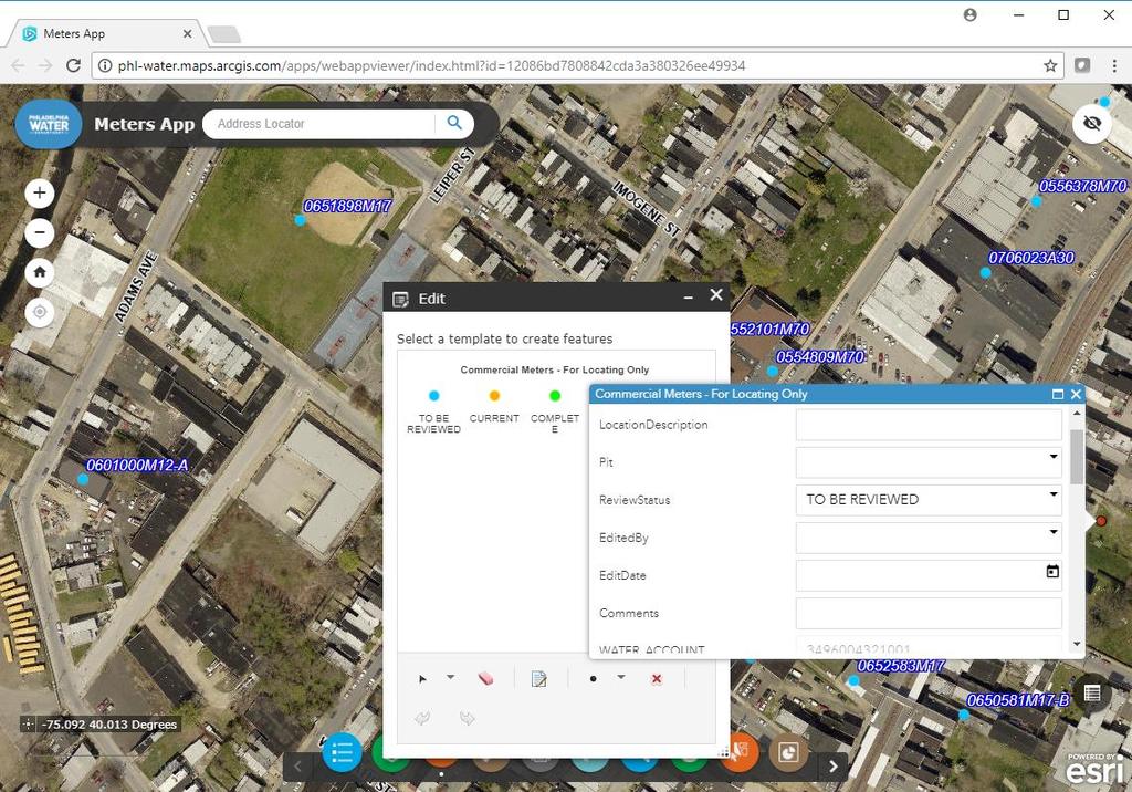
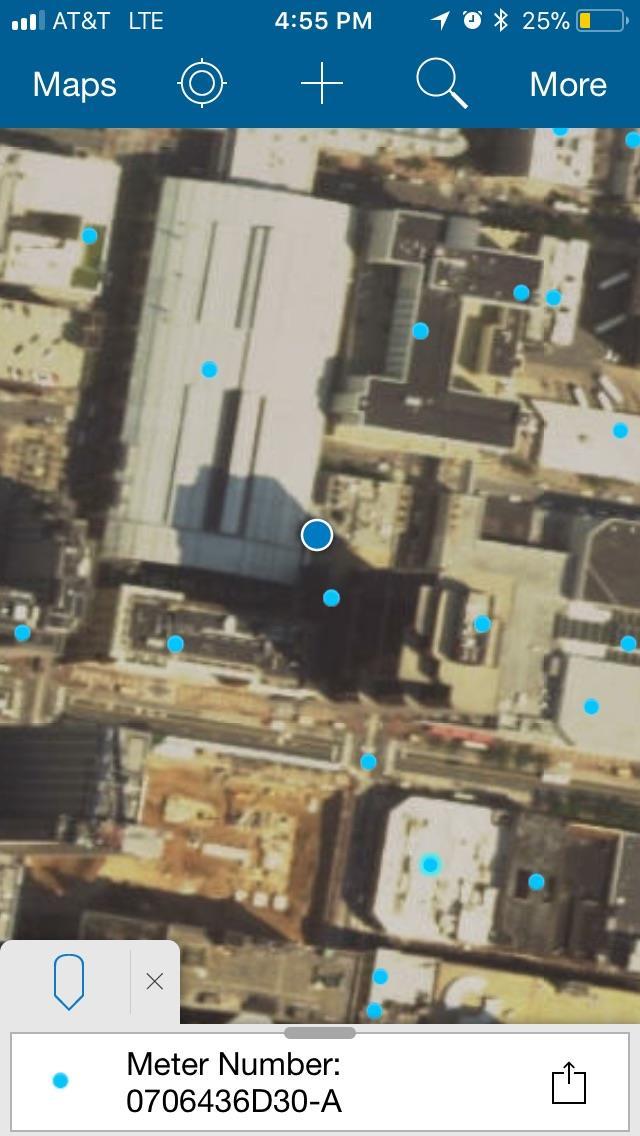
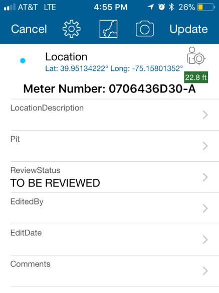
23 Timothy J. Smith- Operations Administration Administrative Technician Started with PWD in 2013 Dispatching for Meter Shop Reporting AMI PHILADELPHIA WATER DEPARTMENT MEGAN CLARKIN Land Development & Stormwater Management Web Apps

24 Meter Shop Work Order Creation & Visualization No classes or school required to use an ArcGIS web app Windows & Browser Easy to use controls PHILADELPHIA WATER DEPARTMENT TIM SMITH Increasing Efficiency and Visualization of Work Order Creation

25 Meter Shop Work Order Creation & Visualization Maps speed up the intake of information Displays natural boundaries PHILADELPHIA WATER DEPARTMENT TIM SMITH Increasing Efficiency and Visualization of Work Order Creation

26 Meter Shop Work Order Creation & Visualization Displays recidivism i.e. suspicious usage Displays areas that stand out Displays overlooked accounts PHILADELPHIA WATER DEPARTMENT TIM SMITH Increasing Efficiency and Visualization of Work Order Creation

27 Meter Shop Work Order Creation & Visualization Arc Web App lets users see the impact of operations PHILADELPHIA WATER DEPARTMENT TIM SMITH Increasing Efficiency and Visualization of Work Order Creation
28 Meter Shop Work Order Creation & Visualization Old vs New For the meter shop, existing proprietary mapping software displays accounts already in the workflow. ARC web app can display the total population of accounts before they enter the workflow and monitor them after they are completed ARC web app displays features better than old system Fresh data Info Summary PHILADELPHIA WATER DEPARTMENT TIM SMITH Increasing Efficiency and Visualization of Work Order Creation

29 Meter Shop Work Order Creation & Visualization PHILADELPHIA WATER DEPARTMENT TIM SMITH Increasing Efficiency and Visualization of Work Order Creation

30 Meter Shop Work Order Creation & Visualization Multiple users can utilize this tool to view different layers using the same app PHILADELPHIA WATER DEPARTMENT TIM SMITH Increasing Efficiency and Visualization of Work Order Creation

31 Meter Shop Work Order Creation & Visualization Data can be exported to list format for traditional analysis and utilization PHILADELPHIA WATER DEPARTMENT TIM SMITH Increasing Efficiency and Visualization of Work Order Creation


32 Questions, Ideas, Comments? phl-water.maps.arcgis.com phl.maps.arcgis.com
Creating 3D Interior Maps for Campus Planning
 Creating 3D Interior Maps for Campus Planning ESRI User Conference 2016 Parvaneh Kossari Harvard Planning & Project Management Antje Kunze SMARTERBETTERCITIES Harvard Planning & Project Management Harvard
Esri Roads and Highways: Integrating and Developing LRS Business Systems
 Esri Roads and Highways: Integrating and Developing LRS Business Systems Tom Hill Esri UC 2014 Technical Workshop Overview: Esri Roads and Highways Esri UC 2014 Technical Workshop Esri Roads and Highways:
Outfall Retrofit Feasibility Study
 Outfall Retrofit Feasibility Study 2013 APWA-NC SWM Conference September 16-17, 2013 Overview PWD history with outfall retrofits Project setting Review of screening factors and weighting scale QA/QC process
Using AutoCAD Civil 3D and ESRI ArcGIS to meet LEED-ND (Neighborhood Development) Requirements NDIA O Brien & Gere. All Rights Reserved.
 Requirements NDIA O Brien & Gere. All Rights Reserved.") Using AutoCAD Civil 3D and ESRI ArcGIS to meet LEED-ND (Neighborhood Development) Requirements NDIA 12457 1 Using AutoCAD Civil 3D and ESRI ArcGIS to meet LEED-ND (Neighborhood Development) Requirements
Using AutoCAD Civil 3D and ESRI ArcGIS to meet LEED-ND (Neighborhood Development) Requirements NDIA 12457 1 Using AutoCAD Civil 3D and ESRI ArcGIS to meet LEED-ND (Neighborhood Development) Requirements
Philadelphia Water Department, Green Infrastructure Implementation Graduate Internship Opportunities Summer 2017
 PHILADELPHIA WATER 1101 Market Street Philadelphia, Pennsylvania 19107-2994 Debra McCarty, Commissioner Philadelphia Water Department, Green Infrastructure Implementation Graduate Internship Opportunities
MUNICIPAL SEPARATE STORM SEWER SYSTEM 2011 ANNUAL REPORT
 MUNICIPAL SEPARATE STORM SEWER SYSTEM 2011 ANNUAL REPORT Permit Number 85-03-0-04 March 2012 Prepared by Department of Environmental Health and Safety and Facilities Planning and Management 2809 Daley
BMP Designer: Empowering Residents to Control Stormwater, One House at a Time. Presented by: Stephen Bourne, P.E.
 BMP Designer: Empowering Residents to Control Stormwater, One House at a Time Presented by: Stephen Bourne, P.E. 1 Lake Tahoe A natural resource Known world-wide for skiing, hiking, water sports Also home
Serving Fremont Employees with a One Stop Shop Enterprise Web App
 Serving Fremont Employees with a One Stop Shop Enterprise Web App Enterprise GIS: Lessons from the Trenches By John Leon and Christine Frost 2015 Esri international User Conference 1 Introduction Phases
GeoPlanner SM for ArcGIS : An Introduction
 GeoPlanner SM for ArcGIS : An Introduction Greg Pleiss Robert Stauder Esri UC 2014 Technical Workshop Agenda Application Overview Specific Capabilities - Configuration - Avaliable Data - Spatial Analysis
Toward a Robust Flood Emergency Evacuation Integration of 2-D Hydraulic Modeling and Dynamic Evacuation Routing
 Toward a Robust Flood Emergency Evacuation Integration of 2-D Hydraulic Modeling and Dynamic Evacuation Routing Esri User Conference 2016 Sheng Tan, GISP June 29, 2016 Presentation Overview Study purpose
Highlands Region Stormwater Management Program Guidance
 DRAFT Highlands Region Stormwater Management Program Guidance Release Date: January 2016 Abstract This guidance document provides an overview of the Highlands Stormwater Management Program. It is intended
Portland International Airport Storm Water Master Plan June 5, Susan Aha Water Quality Manager
 Portland International Airport Storm Water Master Plan June 5, 2013 Susan Aha Water Quality Manager 1 Presentation Overview What is storm water and why is it important to manage Regulatory framework for
Campus Map Applications
 Campus Map Applications - use cases from Göttingen - M.SC. CLAUDIA MALZER GEORG-AUGUST-UNIVERSITÄT GÖTTINGEN INSTITUTE OF GEOGRAPHY DEPT. CARTOGRAPHY, GIS & REMOTE SENSING GOLDSCHMIDTSTR. 5 37077 GÖTTINGEN
Stormwater Management Guidance Manual: Customizing and optimizing stormwater requirements for port-specific land uses and customers.
 Stormwater Management Guidance Manual: Customizing and optimizing stormwater requirements for port-specific land uses and customers. June 30, 2016 Port of Tacoma Environmental Project Manager: Anita Fichthorn
Framework for Post-Construction SMP Program Management
 Framework for Post-Construction SMP Program Management Presented by: Aaditya Pise, P.E. (JMT) Alan Fody, P.E. (PWD) Presentation Agenda Overview of Philadelphia Water Stormwater Management Regulations
PA Conservation Explorer. June 2015
 PA Conservation Explorer June 2015 Topics for today Current Conservation Tools PA Conservation Explorer Conservation Planning PNDI Environmental Review Next Steps Current Conservation Tools Current Planning
Brigitte A. Berger, Director of Engineering
 Brigitte A. Berger, Director of Engineering Wilmette s Sewer System Overview of Wilmette s Sewer System Green vs. Gray? Stormwater Action Plan Regulatory Compliance Why Homes Flood What can
Welcome to Esri's Software Export Control Classification Number (ECCN) Matrix August 2017
 Matrix August 2017") Welcome to Esri's Software Export Control Classification Number (ECCN) Matrix August 2017 This portion of the Esri web site is to provide information regarding the export control classification of Esri
Welcome to Esri's Software Export Control Classification Number (ECCN) Matrix August 2017 This portion of the Esri web site is to provide information regarding the export control classification of Esri
Philadelphia Stormwater Management Criteria: What Are the Neighbors Doing? - A Peer City Comparison
 Philadelphia Stormwater Management Criteria: What Are the Neighbors Doing? - A Peer City Comparison S. Randall, C. Marjoram & M.J. Vanaskie Pennsylvania Stormwater Management Symposium, Villanova University
2.7 ac park. TOTAL 5,403 DU 1,297,900 sf 1,105,450 sf 3.87 ac 5,563 DU 1,121,200 sf 1,105,450 sf 3.87 ac
 PLAN AMENDMENT 2013-I-B1: SEVEN CORNERS SPECIAL STUDY Summary of Pre-staffing Comments Planner: Bernard Suchicital bsuchi@fairfaxcounty.gov (703) 324-1254 Background On October 29, 2013, the Board of Supervisors
Village of Forest Park. July 27, Sewer Separation Evaluation
 Village of Forest Park July 27, 2015 Sewer Separation Evaluation Presentation Overview Study Background Historic Nature of Forest Park Drainage Scale of Flooding Problem Forest Park Sewer System Background
NJDEP Stormwater Initiatives: MS4s & GIS
 NJDEP Stormwater Initiatives: MS4s & GIS Mid-Atlantic Geospatial Transportation Users Group GIS Day - November 5, 2015 NJ Department of Environmental Protection Bureau of Nonpoint Pollution Control Kyra
THE VALUE IS IN THE SOFTWARE
 Max Gutberlet September 27, 2017 THE VALUE IS IN THE SOFTWARE How Honeywell Saves You Money THE SCOPE OF TODAYS PRESENTATION 1 Honeywell PowerSpring Light-weight Meter Data Collection fully integrated
Being Prepared and Providing Situational Awareness, through the use of Web GIS
 Being Prepared and Providing Situational Awareness, through the use of Web GIS Captain Michael Brady, Commanding Officer GIS Unit, Fire Department City of New York Who We Are 11,198 Firefighters and Fire
Esri Maps for MicroStrategy: Tips and tricks Chaka Clarke & Constantinos Papantoniou
 Esri Maps for MicroStrategy: Tips and tricks Chaka Clarke & Constantinos Papantoniou Esri UC 2016 Demo Theater Esri Maps for MicroStrategy: Tips and tricks Esri Maps for MicroStrategy brings location analytics
Pennsylvania Conservation Explorer Conservation Planning and PNDI Environmental Review. September 29, 2015 Greg Podniesinski Kent Taylor
 Pennsylvania Conservation Explorer Conservation Planning and PNDI Environmental Review September 29, 2015 Greg Podniesinski Kent Taylor Current Conservation Planning Tool County Natural Heritage Inventories
13 Extending the Esri Enterprise Licence Agreement
 Clause 13 in Report No. 10 of Committee of the Whole was adopted, without amendment, by the Council of The Regional Municipality of York at its meeting held on May 21, 2015. 13 Extending the Esri Enterprise
Sara Heger. septic.umn.edu H2OandM.com
 Sara Heger sheger@umn.edu septic.umn.edu H2OandM.com Professional Training Designers, Inspectors, Installers, Service Providers, Maintainers Research and Demonstration Homeowner Operation & Maintenance
DC Clean Rivers Project Green Infrastructure Program
 District of Columbia Water and Sewer Authority George S. Hawkins, General Manager Briefing on: DC Clean Rivers Project Green Infrastructure Program Briefing for: American Water Resources Association National
AMI-OMS Integration. September 19 th 2018 Electric T&D EAP Alexandra Ryder Engineer, Smart Grid
 AMI-OMS Integration September 19 th 2018 Electric T&D EAP Alexandra Ryder Engineer, Smart Grid Agenda 2 PECO Overview AMI Network Overview AMOS Introduction Nested Outage Identification Automatic Meter
ArcGIS Data Reviewer. Planning and Deploying Data Quality Services. Edwin Waite & Shankar Chandrasekaran. Esri UC 2014 Technical Workshop
 ArcGIS Data Reviewer Planning and Deploying Data Quality Services Edwin Waite & Shankar Chandrasekaran Esri UC 2014 Technical Workshop A few examples of why data validation matters Esri UC 2014 Technical
Editing & Maintaining Parcels with ArcMap
 Editing & Maintaining Parcels with ArcMap Amy Andis Jason Camerano Esri UC 2014 Technical Workshop What to expect from this Tech Workshop An introduction to the Parcel Fabric A detailed explanation of
ROGUE VALLEY SEWER SERVICES STORMWATER MANAGEMENT PROGRAM (SWMP)
") ROGUE VALLEY SEWER SERVICES STORMWATER MANAGEMENT PROGRAM (SWMP) 1.0 INTRODUCTION This Stormwater Management Program (SWMP) for Rogue Valley Sewer Services (RVS) has been developed to meet the Municipal
ROGUE VALLEY SEWER SERVICES STORMWATER MANAGEMENT PROGRAM (SWMP) 1.0 INTRODUCTION This Stormwater Management Program (SWMP) for Rogue Valley Sewer Services (RVS) has been developed to meet the Municipal
Summary of Action Strategies
 Strategic Action Plan 6 Summary of Action Strategies Action Strategy Categories: 1. Organization and Management 2. Implementation 3. Marketing and Promotion This chapter summarizes all of the action strategies
E x E C U T I v E S U M M A R y / P L A N N I N G C O N T E x T 14 //
 14 // executive summary / planning context COMMUNITY GREENING PLAN PLANNING CONTEXT Capital Region Water has entered into a partial consent decree with the United States Department of Justice to address
COMMUNITY DEVELOPMENT SERVICES PLANNING AND BUILDING DEPARTMENT PLACERVILLE OFFICE:
 COMMUNITY DEVELOPMENT SERVICES PLANNING AND BUILDING DEPARTMENT http://www.edcgov.us/devservices/ PLACERVILLE OFFICE: LAKE TAHOE OFFICE: 2850 Fair Lane Court, Placerville, CA 95667 924 B Emerald Bay Rd.
U.S. EPA National Stormwater Calculator
 Chesapeake Bay Program STAC Workshop: Monitoring and Assessing Impacts of Changes in Weather Patterns and Extreme Events on BMP Siting and Design U.S. EPA National Stormwater Calculator Jason Bernagros
PotterNet Fire & Facility Supervising Station
 Features Connect up to 1000 Potter panels in a single building, local campus, or multiple sites worldwide using LAN/WAN/Internet Native Ethernet networking connectivity with fire panels and client stations,
CHATHAM COUNTY S PATH TO SUSTAINABILITY - THE NATURAL RESOURCES SIDE
 CHATHAM COUNTY S PATH TO SUSTAINABILITY - THE NATURAL RESOURCES SIDE GEORGIA ENVIRONMENTAL CONFERENCE SAVANNAH, GEORGIA AUGUST 23, 2012 Jackie Jackson Teel Chatham County-Savannah Metropolitan Planning
Water Resources and Policy Initiatives CSU Campus Water Use Calculations Standard Operating Procedures February 26, 2016
 Water Resources and Policy Initiatives CSU Campus Water Use Calculations Standard Operating Procedures February 26, 2016 Project Background California State University (CSU) campuses face a challenge in
The Benefits and Challenges Associated with Green Infrastructure Practices
 The Benefits and Challenges Associated with Green Infrastructure Practices Thomas M. Evans ASLA, LEED AP Regional Green Infrastructure Design Services Director OWEA Technical Conference, June 20, 2013
Can Urban Redevelopment Restore Aquatic Resources
 Can Urban Redevelopment Restore Aquatic Resources with Standards for Stormwater Retention and Landscape Performance? Rebecca C. Stack District of Columbia Department of the Environment Industry, Agriculture,
Part 4: CRS Stormwater Management Activity (450) and Urban Flooding Best Practices
 and Urban Flooding Best Practices") Coastal Resilience through Community Engagement Webinar Series Part 4: CRS Stormwater Management Activity (450) and Urban Flooding Best Practices 1:00 2:30pm CT 8 Today s Moderator Chad Berginnis, CFM
Coastal Resilience through Community Engagement Webinar Series Part 4: CRS Stormwater Management Activity (450) and Urban Flooding Best Practices 1:00 2:30pm CT 8 Today s Moderator Chad Berginnis, CFM
INTERNATIONAL GUIDELINES
 INTERNATIONAL GUIDELINES ON URBAN & TERRITORIAL PLANNING Bridge for Planning & Innovation 53rd ISOCARP Congress Smart Communities October 24, 2017 Portland, USA 1/3 BACKGROUND JUST TO NAME A FEW WHERE
Implementing sustainable water strategy through development industry engagement
 Implementing sustainable water strategy through development industry engagement Ian Director, Organica Engineering, Melbourne, Australia E-mail: iadams@organicaeng.com.au Edward Cotter Sustainability Leader,
DynAMo Alarm & Operations Management
 Connected Plant DynAMo Alarm & Operations Management Solution Note Delivering operations integrity through better plant safety, availability and compliance across your entire enterprise Honeywell s DynAMo
Annual Report East Pennsboro Township s Stormwater Management Program
 Annual Report East Pennsboro Township s Stormwater Management Program April 2016 March 2017 Where Does Stormwater Go In the Township? Travels over land Carried through Municipal Separate Storm Sewer System
Climate Smart Communities Green Infrastructure Case Studies
 New York State Water Resources Institute Climate Smart Communities Green Infrastructure Case Studies Emily Vail Hudson River Estuary Program NYS Department of Environmental Conservation Cornell University
4-H SOIL & WATER PROJECT UPDATE. Indiana 4-H. Youth Education
 4-H SOIL & WATER Indiana 4-H Youth Education PROJECT UPDATE PRESENTATION OUTLINE Project Background What, Why, How? Who are the Partners? What is 4-H Youth Education? Project Goals How will 4-H Implement?
Green Infrastructure and LID Practice Construction Workshop
 Technical Workshops Sunday, August 12, 2018 8:00 a.m. 12:00 p.m. - $195.00 Green Infrastructure and LID Practice Construction Workshop Make Sure Your BMPs are Constructed Properly: Green Infrastructure
4. UTILITIES ELEMENT.
 4. UTILITIES ELEMENT. The purpose of this element is to provide for necessary public facilities and services correlated to future land use projections and population demand. Utilities Sub-Elements (A)
Methods to Simulate the Impact of BMPs
 LA221 Project Ortega Watershed Demonstration Area, Quito Ecuador Ricardo da Cruz e Sousa Master of Landscape Architecture & Environmental Planning University of California, Berkeley December 2011 Ortega
Keyport. Vision for Keyport
 Keyport Vision for Keyport Keyport is a rural, historic waterfront village bounded and limited in size by its natural borders of water and the Naval Undersea Warfare Center. The community consists primarily
Live, Work, Locate and Site Selector
 Configuring Live, Work, Locate and Site Selector in Your Community John Hauck ArcGIS for State Government Solutions for Esri s government customers Series of useful maps and apps focused on government
Stormwater Protection Program October 15, 2015
 Stormwater Protection Program October 15, 2015 1. INTRODUCTION 1.1. Purpose Indiana University Environmental Health and Safety (IUEHS) has developed the Stormwater Protection Program to identify the requirements
Groundwater Flow Modeling of ROW Bioswales Adjacent to Residential Buildings
 Groundwater Flow Modeling of ROW Bioswales Adjacent to Residential Buildings 2016 AWRA Summer Specialty Conference: GIS and Water Resources IX Zachary Benedetto Arup Outline Background on NYC Green Infrastructure
2.6 Pawtucket. Pawtucket Impervious Cover Map (61.4% Impervious)
") 2.6 Pawtucket Pawtucket Impervious Cover Map (61.4% Impervious) The City of Pawtucket is approximately 8.7 square miles and is heavily residential with some commercial and industrial land. Table 2.14 below
2.6 Pawtucket Pawtucket Impervious Cover Map (61.4% Impervious) The City of Pawtucket is approximately 8.7 square miles and is heavily residential with some commercial and industrial land. Table 2.14 below
The New Mexico Opportunity Mapping Project
 The New Mexico Opportunity Mapping Project Elaine Kohrman 1, Joe Zebrowski 2, Susan Rich 3 1 United States Forest Service, Cibola National Forest 2 New Mexico Highlands University, New Mexico Forest and
University of the District of Columbia Van Ness Campus Master Plan Community Open House 3. December 8, 2010
 University of the District of Columbia Van Ness Campus Master Plan Open House 3 December 8, 2010 Introductions Sequence of Work: Campus Master Plan BEGIN: INTRODUCE AND START WORK Project Initiation Team
GIS-Enabled Rain Garden Design: A Case Study in Austin, Texas. GIS in Water Resources (C E 394K-3) Clint Smith, E.I.T.
 Clint Smith, E.I.T.") GIS-Enabled Rain Garden Design: A Case Study in Austin, Texas GIS in Water Resources (C E 394K-3), E.I.T., MSCE 12/07/2018 Table of Contents: 1. Abstract 3 2. Introduction 4 2.1 Background 4 2.2 Project
GIS-Enabled Rain Garden Design: A Case Study in Austin, Texas GIS in Water Resources (C E 394K-3), E.I.T., MSCE 12/07/2018 Table of Contents: 1. Abstract 3 2. Introduction 4 2.1 Background 4 2.2 Project
GIS Training of Undergraduates: Campus Stormwater Mapping. Joanne Logan, University of Tennessee. Gordie Bennett, University of Tennessee
 GIS Training of Undergraduates: Campus Stormwater Mapping Joanne Logan, University of Tennessee Gordie Bennett, University of Tennessee Seth Benge, University of Tennessee Tim Prather, University of Tennessee
Stormwater Master Plan Update. City Council Briefing January 8, 2019
 Stormwater Master Plan Update City Council Briefing January 8, 2019 1 Stormwater Master Plan Update January 8, 2019 Agenda Background for Update Stormwater Modeling and Calibration Visualizations of Results
Using ANM Mobile CHAPTER
 CHAPTER 19 Date: 3/22/13 This chapter describes Cisco ANM Mobile, which allows you to access your ANM server or ANM Virtual Appliance and manage your devices using a mobile device such as an iphone or
Agenda. NPDES Phase II Program (US EPA, 2003 Pending 2009) Costs of Stormwater Management and How to Structure a Stormwater Utility
 Costs of Stormwater Management and How to Structure a Stormwater Utility") Costs of Stormwater Management and How to Structure a Stormwater Utility Richard Claytor, P.E. Horsley Witten Group, Inc How to Fund Your Municipal Stormwater Program April 30, 2009 Peabody Institute Library
Costs of Stormwater Management and How to Structure a Stormwater Utility Richard Claytor, P.E. Horsley Witten Group, Inc How to Fund Your Municipal Stormwater Program April 30, 2009 Peabody Institute Library
Practices and Challenges in Adopting Esri Roads and Highways in the U.S.
 Practices and Challenges in Adopting Esri Roads and Highways in the U.S. Xiao Qin, Zhaoxiang He, Zengwang Xu University of Wisconsin-Milwaukee Bo Guo Gistic Research Inc. Kelly Schieldt Wisconsin Department
The Economic Value of Protected Open Space in Southeastern Pennsylvania
 The Economic Value of Protected Open Space in Southeastern Pennsylvania SUMMARY REPORT Looking at the landscape. 200,000+ Acres Protected in Southeastern Pennsylvania. 30% Privately Owned or Eased Lands
York L. Phillips, AICP, Planning & Zoning Division Manager. APPLICANT: Carter Engineering Consultants, agent for Cordell Enterprises, owner.
 GLYNN COUNTY BOARD OF COMMISSIONERS MEMO TO: Glynn County Islands Planning Commission 701 G Street Brunswick, Georgia 31520 Phone: (912) 554-7400 Fax: (912) 554-7596 FROM: SUBJECT: York L. Phillips, AICP,
Portland International Airport Storm Water Master Plan April 6, 2016
 Portland International Airport Storm Water Master Plan April 6, 2016 Susan Aha Senior Manager, Water Resources Brian Freeman Manager, Civil Engineering 1 Presentation Overview Why is storm water important
Building Green: An Update on Atlanta's Green Infrastructure Approach
 City of Atlanta Mayor Kasim Reed Department of Watershed Management Building Green: An Update on Atlanta's Green Infrastructure Approach Todd Hill, PE, LEED AP, EnvSP Watershed Director 2016 Eastern Regional
How Woodside Properties is Using GIS to Manage its Facilities
 How Woodside Properties is Using GIS to Manage its Facilities NY GeoCon 15 Woodside Properties, LLC GIS for Facilities? Geospatial has always been common place for mapping outside of the building, but
MUNICIPAL SEPARATE STORM SEWER SYSTEM 2008 ANNUAL REPORT
 MUNICIPAL SEPARATE STORM SEWER SYSTEM 2008 ANNUAL REPORT Permit Number 85-03-0-04 March 2009 Prepared by: Iowa State University Department of Environmental Health and Safety 2809 Daley Drive Ames, Iowa
Desigo Control Point The embedded building management station
 Desigo Control Point The embedded building management station www.siemens.com/buildingtechnologies We spend 90% of our lives in buildings We live, work, learn, sleep and recover in buildings. Page 2 That
Indoor Location, Tracking, and Routing
 2013 Esri International User Conference July 8 12, 2013 San Diego, California Technical Workshop Indoor Location, Tracking, and Routing Wolfgang Hall, Esri Tobias Donaubauer, Infsoft Robert Garrity, Esri
Overview of Southwestern Pennsylvania Commission s (SPC) 2040 Long Range Transportation Plan (LRTP)
 2040 Long Range Transportation Plan (LRTP)") Overview of Southwestern Pennsylvania Commission s (SPC) 2040 Long Range Transportation Plan (LRTP) Presented to Pennsylvania Agency Coordination Meeting May 27, 2015 Doug Smith & Ryan Gordon 1 Southwestern
Overview of Southwestern Pennsylvania Commission s (SPC) 2040 Long Range Transportation Plan (LRTP) Presented to Pennsylvania Agency Coordination Meeting May 27, 2015 Doug Smith & Ryan Gordon 1 Southwestern
Pasco County Watershed Meeting for Flood Impacted Areas Port Richey Watershed
 Pasco County Watershed Meeting for Flood Impacted Areas March 15, 2017 Regency Park Library, 9701 Little Road, New Port Richey, Pasco County The following is a summary of the meeting held on March 15,
DAI600 - Fire and Egress Door Assembly Inspection (Online Version) Syllabus
 Syllabus") DAI600 - Fire and Egress Door Assembly Inspection (Online Version) Syllabus Registration Cutoff Date: Friday, October 5, 2012 Course Dates: Course consists of twelve 2 to 3 hour-long live meetings (see
DAI600 - Fire and Egress Door Assembly Inspection (Online Version) Syllabus Registration Cutoff Date: Friday, October 5, 2012 Course Dates: Course consists of twelve 2 to 3 hour-long live meetings (see
Enterprise GIS Architecture Deployment Options
 2013 Esri International User Conference July 8 12, 2013 San Diego, California Technical Workshop Enterprise GIS Architecture Deployment Options Andrew Sakowicz Esri UC2013. Technical Workshop op. Introduction
Compact Product Suite Compact HMI 6.0 Overview ABB
 Compact Product Suite Compact HMI 6.0 Overview ABB 2 OVERVIEW COMPACT HMI VERSION 6.0 Compact HMI A feature-rich human-machine interface Another feature is the high performance prefabricated, reusable
Low-Impact Development Code Update. Thurston County Community Stakeholder Group June 25, 2015
 Low-Impact Development Code Update Thurston County Community Stakeholder Group June 25, 2015 Overview The County is required to review its local development codes under the latest NPDES municipal stormwater
Sustainable Stormwater Management through Green Infrastructure. Jersey City Public School #5
 Green Infrastructure Site Evaluation Friday, October 25 th, 2013 Sustainable Stormwater Management through Green Infrastructure Jersey City Public School #5 FORMAT: (15 minutes) An Introduction to Stormwater
NORTH KINGSTOWN PILOT PROJECT May 9, 2016 North Kingstown Town Council
 Engaging RI Local Governments in Hazard Mitigation and Coastal Resilience NORTH KINGSTOWN PILOT PROJECT May 9, 2016 North Kingstown Town Council Teresa A. Crean, AICP University of Rhode Island Coastal
I. INTRODUCTION. identify long-term capital improvements and rehabilitation measures for the existing drainage system;
 I. INTRODUCTION The Town of Windsor, Colorado is presently experiencing rapid growth and development within the boundaries of several of its major drainage basins. As growth continues within these basins,
THE CITY OF DELAWARE, OHIO ILLICIT DISCHARGE DETECTION AND ELIMINATION PLAN
 THE CITY OF DELAWARE, OHIO ILLICIT DISCHARGE DETECTION AND ELIMINATION PLAN OCTOBER 2014 Table of Contents Section 1.0 Overview/Background... 1 Section 2.0 - General Permit Information... 2 Section 3.0
Green Infrastructure Resources for Coastal Flood Risk Management
 Natural Floodplain Functions Alliance (NFFA) WEBINAR SERIES PRESENTS: Green Infrastructure Resources for Coastal Flood Risk Management Maria Honeycutt, PhD, CFM Lauren Long Tashya Allen NFFA Webinars Hosted
Fire O&M AiM. Need help: call IMS https://sscaimapp.assetworks.com/fmax
 Fire O&M AiM 2016 Need help: call IMS 862-3388 https://sscaimapp.assetworks.com/fmax Fire O&M - 2 Table of Contents What is Fire O&M?... 5 What Appears in Fire App?... 5 Fire O&M Settings... 6 Fire O&M
TRANSIT-ORIENTED DEVELOPMENT POLICY DRAFT. City Planning and Development Department Kansas City, Missouri
 TRANSIT-ORIENTED DEVELOPMENT POLICY DRAFT City Planning and Development Department Kansas City, Missouri What is Transit Oriented Development (TOD)? Development that focuses land uses around a transit
North Street Reconstruction & Integrated Stormwater Management System
 OWEA Watershed Workshop-October 30 th, 2014 North Street Reconstruction & Integrated Stormwater Management System Ted Blahnik, PE Principal-Williams Creek Consulting North Street: A Case Study for Integrated
Tracking spatiotemporal patterns of building vulnerabilities and evacuations during flood hazards
 Tracking spatiotemporal patterns of building vulnerabilities and evacuations during flood hazards Shane Hubbard Junchuan Fan Kathleen Stewart Emily White The University of Wisconsin Madison, SSEC/CIMSS
Village of Glenview Appearance Commission
 Village of Glenview Appearance Commission STAFF REPORT July 23, 2014 TO: Chairman and Appearance Commissioners CASE #: A2014-059 LOCATION: 727 Harlem Avenue FROM: Community Development Department PROJECT
Selecting Least Cost Green Infrastructure. James W. Ridgway, PE September 29, 2015
 Selecting Least Cost Green Infrastructure James W. Ridgway, PE September 29, 2015 Integrated Water Management?? IS GREEN INFRASTRUCTURE LESS COSTLY THEN GRAY INFRASTRUCTURE? Cost of Green Infrastructure
Sustainable Stormwater Management with Low Impact Development (LID)
") Sustainable Stormwater Management with Low Impact Development (LID) Chui Ting Fong, May Department of Civil Engineering The University of Hong Kong HKIE Seminar Nov 27, 2014 1 Hydrologic Impact of Urbanization
Sustainable Stormwater Management with Low Impact Development (LID) Chui Ting Fong, May Department of Civil Engineering The University of Hong Kong HKIE Seminar Nov 27, 2014 1 Hydrologic Impact of Urbanization
UNIVERSITY OF NORTHERN IOWA
 UNIVERSITY OF NORTHERN IOWA Municipal Separate Storm Sewer System September 2008 Report Permit Number 07-09-0-04 August 2008 Prepared by: University of Northern Iowa Environmental Health and Safety Office
DC Clean Rivers Project Green Infrastructure Program Potomac River Project A
 District of Columbia Water and Sewer Authority George S. Hawkins, Chief Executive Officer and General Manager Briefing on: DC Clean Rivers Project Green Infrastructure Program Potomac River Project A Briefing
Tools to facilitate the use of Soil Maps in Emilia-Romagna region (Italy) Paola Tarocco
 Paola Tarocco") Tools to facilitate the use of Soil Maps in Emilia-Romagna region (Italy) Paola Tarocco Soil maps Vs Thematic maps Soil maps are not easy to manage. Legends are usually based on soil classifications (e.g.
Tools to facilitate the use of Soil Maps in Emilia-Romagna region (Italy) Paola Tarocco Soil maps Vs Thematic maps Soil maps are not easy to manage. Legends are usually based on soil classifications (e.g.
DryLINK TRAINING Phoenix DryMAX XL and DryLINK
 DryLINK TRAINING Phoenix DryMAX XL and DryLINK FREE MOBILE APP 125 PPD XL LGR DEHUMIDIFIER WITH BLUETOOTH BE EVERYWHERE AT ONCE TABLE OF CONTENTS Introduction...3 Initial Setup Downloading the App...4
MONTGOMERY COUNTY PLANNING DEPARTMENT THE MARYLAND-NATIONAL CAPITAL PARK AND PLANNING COMMISSION
 MONTGOMERY COUNTY PLANNING DEPARTMENT THE MARYLAND-NATIONAL CAPITAL PARK AND PLANNING COMMISSION MCPB Item No. 6 Date: 7.22.13 Bethesda Purple Line Station Minor Master Plan Amendment, Scope of Work Elza
2011 ASLA Design Awards. Westside Creeks Restoration Plan Merit Award AECOM, Fort Collins. Planning & Urban Design
 2011 ASLA Design Awards Westside Creeks Restoration Plan Merit Award AECOM, Fort Collins Planning & Urban Design Project Fact Sheet Category of Entry: Rotating Specialty Award: 2011 2011 ASLA Colorado
MUNICIPAL SEPARATE STORM SEWER SYSTEM 2009 ANNUAL REPORT
 MUNICIPAL SEPARATE STORM SEWER SYSTEM 2009 ANNUAL REPORT Permit Number 85 03 0 04 March 2010 Prepared by: Iowa State University Department of Environmental Health and Safety 2809 Daley Drive Ames, Iowa
Development of a web-based interface for simulating alternative conservation practices using APEX
 Development of a web-based interface for simulating alternative conservation practices using APEX ASABE Annual International Meeting, New Orleans, LA 29 July 2015 Presented by: Naresh Pai (Stone Environmental),
Nassau County Cultivating Opportunities for Sustainable Development Nassau County Infill Redevelopment Feasibility Study
 Nassau County Cultivating Opportunities for Sustainable Development Nassau County Infill Redevelopment Feasibility Study NY-CT Sustainable Communities Steering Committee Meeting March 14, 2014 Project