MEATH COUNTY COUNCIL Dunboyne, Clonee & Pace Local Area Plan
|
|
|
- Marian Marshall
- 6 years ago
- Views:
Transcription

1 MEATH COUNTY COUNCIL Dunboyne, Clonee & Pace Local Area Plan Adopted 22 September 2009 Planning Department
2 Dunboyne/Clonee/Pace Local Area Plan Adopted 22 nd September 2009 Prepared by
3 Contents 1.0 INTRODUCTION Introduction Statutory Context Policy Context The Challenge Contents Public Consultation Implementation DUNBOYNE/CLONEE/PACE IN CONTEXT Description of the Local Area Plan Area Existing Physical Characteristics Key Demographic and Socio-Economic Trends Historical and Architectural Significance Natural Heritage Access Services and Utilities LOCAL AREA PLAN STRATEGY Vision - Core Aims Settlement Strategy IAAP Lands Land Use and Transport Strategy Development Opportunities pursued in the Local Area 45 Plan 3.6 Sustainable Development 47
4 4.0 LAND USE Residential Retail Employment & Economic Development Education Provision Community & Social Facilities MOVEMENT Movement Strategy Public Transport Road and Vehicular Transportation Pedestrian Facilities Vehicular and Cycle Parking Employment Zones OVERALL DESIGN Urban Design Rural Design Development Management and Design Policies within Dunboyne and Clonee DEVELOPMENT OF AMENITIES Public Open Space River Amenity Areas Open Space Required Natural Heritage Archaeology and Built Heritage INFRASTRUCTURE Introduction Water Supply 82
5 8.3 Wastewater Collection and Treatment Surface Water Management Flooding Telecommunications Solid Waste Collection and Disposal Energy LAND USE ZONING PROVISIONS AND OBJECTIVES Introduction Strategy for Population Growth Land Use Zoning Matrix PHASING AND IMPLEMENTATION Introduction Phasing Contributions Monitoring and Review 96 Appendix 1 Land Use Zoning Objectives Maps Appendix 2 Lists of persons who made submissions. Appendix 3 Definition of Land Uses Appendix 4 Strategic Environmental Assessment Appendix 5 Appropriate Assessment Appendix 6 Record of Protected Structures
6 Dunboyne/Clonee/Pace Local Area Plan Section 1: Introduction 1.0 INTRODUCTION 1.1 Introduction This Local Area Plan (LAP) relates to the Dunboyne/Clonee/Pace Corridor. In accordance with Section of the Meath County Development Plan , the allocation of future household and population growth in the County will be channelled first and foremost to Dunboyne/Clonee/Pace Rail Corridor, Navan and Drogheda. These centres are also most likely to attract a concentration of major employment generating investment in Meath. On foot of the high capacity, multi-modal transport linkages being rolled out in the Corridor, the goal for the Local Area Plan area is to become a self-sustaining settlement. SS OBJ 1 of the Meath County Development Plan (CDP), states as follows: To prepare Local Area Plans for the urban centres including Dunboyne/Clonee/Pace Corridor shall include inter alia, all lands identified in the Clonsilla to Pace Rail Corridor Section 49 Supplementary Development Contribution Scheme. Table 12 of the CDP identifies Dunboyne/Clonee/Pace Corridor as a Dynamic Cluster which states that opportunities afforded by the new rail stations at Dunboyne and Pace for economic activities should be maximised. This table also requires that sufficient lands are zoned for economic activities at suitable locations. It is also a requirement that adequate lands are zoned for a multiplicity of uses and that densities are appropriate to the location and services available or likely to be available, particularly at public transport nodes. The CDP states that these centres are most likely to attract a concentration of major employment generating investment and should have the greatest accessibility and connectivity. Strategic Settlement Objective, SO2 provides for the preparation of an Integrated Framework Plan for Land Use and Transportation (IFPLUT): To commence the preparation of an Integrated Framework Plan for Land Use and Transportation (IFPLUT) for the area of the Clonsilla to Pace Interchange corridor in County Meath including Clonee in conjunction with relevant public transportation bodies, the DoEHLG and Fingal County Council. The IFPLUT is required to provide inter alia, the following: - the appropriate location for additional public transport nodes along the rail corridor; - the development potential and appropriate land uses around these public transport nodes. Large trip generators such as major employers or town / district centres should be located near the intersection of transportation corridors; - the location, significance and sensitivity of the range of environmental assets and constraints that occur within this corridor, and; - to identify and support the development of areas where significant clusters of power, roads, water and gas could be harnessed to become nationally important areas to accommodate very large scale value added employment while avoiding potential for future environmental and planning conflicts within the corridor. Meath County Council is fully supportive of the delivery of the Clonsilla to Pace Commuter Rail line which is of significant strategic importance to County Meath. Meath County Council are advancing spatial land use strategies in this area that will maximise the development opportunities afforded by the development of the rail line extension in conjunction with the delivery of the M3 Motorway. The development of the rail line and stations plays an integral Page 6
7 Dunboyne/Clonee/Pace Local Area Plan Section 1: Introduction part in the future vision for the area of County Meath located within Metropolitan Area of the Greater Dublin Area. Detailed objectives, proposals, written statements and maps for Dunboyne and Clonee are contained in the County Development Plan. These were prepared for the Meath County Development Plan 2001 and have been incorporated into the County Development Plan pending the preparation of a Local Area Plan for the Corridor. It is a requirement under Section 19(1)(c) of the Planning and Development Act 2000 that in the case of the first Local Area Plan it must be prepared not later than two years after the making of the County Development Plan (2 nd March 2007). This Local Area Plan consists of a written statement accompanied by zoning and objectives maps. It will guide development in the area for six years from the date of adoption by Meath County Council, or until the Local Area Plan is varied or a new Local Area Plan is made. 1.2 Statutory Context Scope of the Local Area Plan This Local Area Plan is made in accordance with the requirements of the Planning and Development Acts and the objectives of the Meath County Development Plan The Act requires that a Local Area Plan consists of a written statement and a plan or plans indicating the objectives in such detail as may be determined by the Local Authority for the proper planning and sustainable development of the area to which it applies, including details of community facilities and amenities and on standards for the design of development and structures. The challenge is to provide a Local Area Plan that will form the basis for a consensus between the Local Authority, the public, landowners, developers and interested parties. This consensus will shape how development should proceed to achieve the objectives for the Corridor, in a manner which is physically, economically and socially sustainable. A further challenge is to provide a document that is sufficiently prescriptive to achieve the objectives while allowing for flexibility to account for economic and social changes that may occur over the plan period. It must also facilitate the generation of a built environment which is attractive and distinctive and which creates a sense of place for those who visit, live and work there Dunboyne/Clonee/Pace Local Area Plan This Local Area Plan is a statutory document which contains guidelines as to how the Dunboyne/Clonee/Pace Corridor should develop over the Plan period and is consistent with the objectives of Meath County Council. The ultimate urban form of the area will be guided by National and Regional guidance in accordance with best planning practice and sustainable development. The written statement contains analysis of statistics, projections and policy objectives. The Local Area Plan maps illustrate graphically the proposals included in the Plan, indicating land-use designations and specific objectives. The base maps upon which the Local Area Plan maps are based may not always be entirely up to date or accurate. Accordingly, where there is conflict between the written statement and the maps, the written statement shall prevail. The Meath County Development Plan provides the primary policy context for this Local Area Plan. The County Development Plan sets out the vision, policy framework and specific objectives for the future development of the County for a period of six years. The policies and objectives of this Local Area Plan are consistent with those of the County Development Plan. The County Development Plan is the principal document and takes precedent over the Local Area Plan in the event of conflict arising between the two. Page 7
8 Dunboyne/Clonee/Pace Local Area Plan Section 1: Introduction Together with Ashbourne and Dunshaughlin the Dunboyne/Clonee/Pace Corridor is designated as part of a Primary Dynamic Cluster in the Regional Planning Guidelines for the Greater Dublin Area. The Corridor has also been identified for significant growth in the current County Development Plan. Dunboyne is identified as a Moderate Growth Town; this is as a result of key infrastructural improvements, including the M3 Motorway and Phase 1 of the Clonsilla to Navan railway line. These changes have significant implications for development of this strategically important part of County Meath. Under the County Development Plan, Dunboyne, Clonee and Pace are largely dealt with together due to their relative proximity, their location on the railway corridor, being in an Area under Strong Urban Influence from the Greater Dublin Area and by their location within the Metropolitan Area. Moderate Growth Towns such as Dunboyne are envisaged as having an interacting and supporting role to their adjacent Large Town; in the case of Dunboyne and Clonee this means interaction with larger settlements in the wider Metropolitan Area. Together these designations mean that the majority of development and population growth in the County will be targeted at Navan and Drogheda Environs and secondly to locations such as the Corridor. Dunboyne and Clonee have historically been under significant development pressure, primarily of a residential nature, due to their geographical proximity to Dublin and good transportation links to the wider GDA. It is anticipated that this development pressure will intensify following the completion of the Clonsilla Pace Interchange, the railway spur, the M3 Motorway and the Dunboyne Western Distributor Road by However, there are also significant opportunities for employment creation. The presence of access to the motorway network provides the transportation infrastructure necessary for lower density industrial, distribution and warehouse related activities. The railway stations provide opportunities for higher density office based employment. These will build on the strong employment base already existing in the Local Area Plan area at Dunboyne Industrial Estate, Bracetown Business Park and the Hub Business Park Significant Effects on the Environment Strategic Environmental Assessment (SEA) A Strategic Environmental Assessment (SEA) has been prepared in response to the requirements of European Communities Council Directive of 2001 on the Assessment of the Effects of Certain Plans and Programmes on the Environment, Directive 2001/42/EC, which came into effect on the 21 st July, The enabling statutory instruments (S.I s), which transpose this Directive into Irish law are the European Communities (Environmental Assessment of Certain Plans and Programmes) Regulations 2004 (S.I. 435 of 2004), and, the Planning and Development (Strategic Environmental Assessment) Regulations 2004 (S.I. 436 of 2004). A SEA outlines the environmental effects of implementing a local area plan prior to its adoption; therefore, SEA is carried out in respect of decisions yet to be made. A Local Area Plan is required to undergo a Strategic Environmental Assessment if it meets the criteria in Article 14B of the Planning and Development (Strategic Environmental Assessment) Regulations 2004, (S.I. 436 of 2004). A SEA is mandatory for the Corridor as it is anticipated that the policies and objectives of this Local Area Plan seek to accommodate a population of more than 10,000 people. The likely significant effects of implementing the Local Area Plan are set out in Chapter 6 of the SEA attached at Appendix 4. As part of the SEA process the baseline environment of the Local Area Plan area was assessed. Table 1.1 below highlights the findings of the assessment. Page 8
9 Dunboyne/Clonee/Pace Local Area Plan Section 1: Introduction Table 1.1: SEA Baseline Environment Biodiversity & Flora and Fauna There are no sites with special designations to protect natural heritage nor are there Areas of Geological Interest, as per the recent Geological Survey of County Meath, within the Local Area Plan area. Human Beings The population of Dunboyne Electoral Division (ED) in 2006 increased by 21.4% from This represents a significant slowdown from the 74.1% rate of increase experienced between 1996 and The population of Clonee is recorded at 1,000 in the 2006 census reflecting a significant increase. The bulk of the population growth is directed to the urban centre of Dunboyne. In Dunboyne ED, the employment increased by almost 22% from 2002 to The overall participation rate in Meath increased by 9.4% while for Dunboyne it increased by 1.4% from the years The current provision of public open space, zoned as such in Dunboyne is 18 hectares. In Clonee, there is a lack of publicly accessible communal open space. Apart from the tennis club and pitch and putt club, the majority of the public open space zoned lands are in agricultural use. Soils & Geology Water Air & Climate The Local Area Plan area lies on grey brown podzolics. The lighter texture grey brown podzolics are good all-purpose soils, while the heavier textured members are highly suited to pasture production. The bedrock geology of the Local Area Plan area is dominated by rocks of Carboniferous Period. The site proposed for development rests on limestone bedrock from the Lower Carboniferous period. The Local Area Plan area falls within the remit of the recently published Eastern River Basin District (ERBD) Draft River Basin Management Plan, which was prepared in accordance with the Water Framework Directive. The ecological status of surface waters in the Local Area Plan area was found to be Moderate or Bad, while groundwater in the Local Area Plan area was found to be of Good status. The groundwater vulnerability map for the Local Area Plan area shows that the area overlies an aquifer classed as predominantly low vulnerability with an area of moderate/high vulnerability to the north and south of Dunboyne. The aquifer is of Local Importance and is classified as being generally moderately productive. The Tolka River flows through Dunboyne from the west, on towards Clonee and then into Fingal County. A significant portion of the central area of the Local Area Plan area comprises the flood plain of the Tolka. While river flows can be relatively low during dry weather periods, serious flooding of both settlements and the surrounding area has been caused by during extreme rainfall events. In response to the flood event of November 2002, The River Tolka Flood Study, 2003 was undertaken to assess flooding issues and to propose alleviation works along the Tolka from lands immediately west of Dunboyne to Dublin City Centre. The majority of these works have been completed. The major source of air pollution within the Local Area Plan Area is road traffic, specifically that on the N3 (and in future the M3 Clonee to North of Kells Scheme). The highest levels of air pollution are experienced along the N3 national primary route and the R156 and R157 regional roads (particularly in Dunboyne). Page 9
10 Dunboyne/Clonee/Pace Local Area Plan Section 1: Introduction Noise Material Assets Cultural Heritage Archaeological Heritage Landscape The noise climate within the Local Area Plan area is dominated by road traffic noise from the N3, which serves as the main traffic artery route between Navan and Dublin, with a high proportion of heavy vehicle traffic. Away from the close proximity to the roads local noise sources are from shops and restaurants, local traffic, community noise and distant sources such as noise from the N3. The terms material assets covers a wide range of items in the Local Area Plan area such as infrastructure, buildings, transport and natural resources. The existing material assets will be utilised, upgraded, and protected where applicable, in the future development of the area. Both Dunboyne and Clonee have a distinct character of their own. There are number of structures within the Local Area Plan area on the Record of Protected Structures as well as other buildings of architectural, artistic, cultural or historic interest within the Local Area Plan area. There are a number of archaeological sites in the Local Area Plan area; however, many of these have little in the way of extant remains. The Landscape Character Assessment by Meath County Council, in 2007 places a value on each landscape character area, ranging from Exceptional to Low. Lowland Landscapes in the Dunboyne area ranged in classification from low to very high. Monitoring of the Local Area Plan area is essential to ensure that the environment is not adversely affected through the implementation of the Local Area Plan. Meath County Council will work with other agencies to gather data for the purposes of monitoring the implementation of the Local Area Plan. Table 1.2 below highlights the proposed monitoring to be carried out. Table 1.2: Proposed Environmental Monitoring Biodiversity & Flora and Fauna Human Beings Soils & Geology Water A monitoring programme will be established by Meath County Council within the lifetime of the Local Area Plan. Habitat loss, habitat deterioration, loss in biodiversity, protected species and protected areas will be monitored. This programme shall be undertaken in consultation with the Biodversity Officer and Heritage Officer of Meath County Council and in conjunction with the National Parks and Wildlife Service, Eastern Regional Fisheries Board and Birdwatch Ireland. The Local Area Plan has taken into account and addressed issues relating to transportation, local service facilities, provision of pedestrian and cyclist facilities, provision of public open spaces and creation of high density well designed residential and urban quarters. During the construction of proposed developments, it is recommended that a monitoring programme be put in place with regard to the potential for soil contamination from construction materials. Monitoring of all water bodies in the Local Area Plan area will be undertaken by Meath County Council in conjunction with the EPA at regular intervals. Water quality monitoring is required to protect and enhance the status of aquatic ecosystems with regard to their water needs. In order to avoid flooding of developed areas while maintaining natural flood plains and avoid unnatural alterations to drainage systems which affect river flows the potential flood risk of proposed development will be monitored. This will be carried out by Meath County Council in conjunction with the Office of Public Works. Page 10
11 Dunboyne/Clonee/Pace Local Area Plan Section 1: Introduction Air & Climate Noise Material Assets Cultural Heritage Archaeological Heritage Landscape Continuous EPA monitoring is carried out at a range of Zone C towns and both urban and rural Zone D locations using continuous monitors in Although no EPA or Local Authority monitoring has been carried out within the region of the Local Area Plan, data from the Zone C and D locations can be used to provide an indication of the prevailing air quality conditions in the region. Any noise complaints and/or noise nuisance issues will be dealt with by Meath County Council throughout the lifetime of the Local Area Plan. Meath County Council will monitor the use of SUDS on all proposed developments at a planning and design stage. Meath County Council water supply is not fully within the control of the Council. It is therefore recommended that a study be carried out for during the lifetime of the Local Area Plan to assess the future water supply in the area. Potential water losses and water quality will need to be monitored. This will be carried out in conjunction with other relevant local authorities and the EPA. Meath County Council will monitor all recorded buildings, monuments and areas of importance. This will be carried out in conjunction with other relevant local authorities and the DoEHLG. It is recommended that a series of 'qualitative' indicators be drafted to monitor the effects of the Plan with regard to the architectural heritage. This will be carried out by Meath County Council and DoEHLG. In order to conserve and enhance valued natural landscapes and the features within them and protect and enhance the sustainable amenity value of water bodies, rivers, and wetlands in the area, Meath County Council will monitor all planning applications to prevent unacceptable alterations to landscape character. Mitigation measures are measures to prevent and reduce any significant impacts on the environment of implementation of the Local Area Plan. Where there are significant impacts, consideration is given in the first instance to preventing such impacts or, if this is not possible, to lessen or offset those impacts. The mitigation measures may be incorporated into the design, specification and development management of the land uses within the Local Area Plan area. The following list has been integrated into the Local Area Plan which is envisaged to prevent, reduce and as fully as possible offset any significant impacts on the environment of implementing the Local Area Plan: Biodiversity and Flora and Fauna Water Protection Surface Water Disposal Waste Services and Waste Water Flooding Soils & Geology Air and Climate Noise Waste Cultural Heritage Archaeological Heritage Landscape Air Quality and Noise Energy Management Page 11
12 Dunboyne/Clonee/Pace Local Area Plan Section 1: Introduction Meath County Council has met the requirements of the SEA Directive by preparing an SEA Environmental Report in parallel with the Dunboyne, Clonee and Pace Local Area Planmaking process. The following organisations have been contacted with regard to scoping the SEA: Environmental Protection Agency (EPA) Department of Environment Heritage and Local Government (DoEHLG) Department of Communications Energy and Natural Resources Office of Public Works, Flood Relief Division National Parks and Wildlife Service Eastern Regional Fisheries Board Department of Transport National Roads Authority Heritage Council Alternatives were considered as part of the Local Area Plan-making process. The submissions and observations received during the public consultation exercises provided the basis for considering alternatives during the early stages of Local Area Plan -making process. The following alternatives were identified: Alternative 1: Do Nothing - setting out the environmental objectives of continuing with the existing plan without review. Alternative 2: Development-driven - setting out the environmental objectives where future growth of the town is in response to requests for additional zoning. Alternative 3: Quality-driven - setting out the environmental objectives of pursuing a scenario that makes a positive contribution to the development of the Local Area Plan area by recognising the importance of conserving and enhancing the quality of the built and natural requirement, as well as the needs of the community. The development and assessment of Plan alternatives comprised of an assessment of each alternative against the environmental objectives as established above, and resultant environmental effects. Screening Assessment as required under Article 6(3) of the Habitats Directive (Council Directive 92/43/EEC) Department of Environment, Heritage and Local Government Circulars SEA 1/08 and NPWS 1/08 relate to the requirement to screen land use plans for potential impacts on designated Natura 2000 sites (Special Area of Conservation (SAC s) or Special Protection Areas (SPA s)). The circulars state that an appropriate assessment means an assessment, based on best scientific knowledge, by a person with ecological expertise, of the potential impacts of the plan on the conservation objectives of any Natura 2000 site (including Natura 2000 sites not situated in the area encompassed by the draft plan or scheme) and the development, where necessary, of mitigation or avoidance measures to preclude negative effects. The potential impacts of policies outside Natura 2000 sites, but potentially impacting upon them (known as ex site impacts) must also be included in the assessment according to the Circulars. There are no SAC s or SPA s in the Corridor or adjoining or in close proximity to the settlements therein. However, the River Tolka flows into Dublin Bay at Clontarf, part of the South Dublin Bay and River Tolka SPA. An appropriate assessment was therefore carried out on the Draft Local Area Plan and the proposed material amendments. The Appropriate Assessment is attached at Appendix 5. No direct impacts on Natura 2000 sites will occur as a result of the implementation of the Dunboyne Clonee Pace Local Area Plan. A number of indirect impacts were identified which could potentially give rise to impacts to Natura 2000 sites. These included impacts to water Page 12
13 Dunboyne/Clonee/Pace Local Area Plan Section 1: Introduction from foul sewerage and surface water. All Natura 2000 sites within 15 kilometres of the Local Area Plan lands were assessed. It was concluded that there will be no foul sewerage impacts because all foul sewerage will be treated in the Ringsend Water Treatment Plant. It was concluded that there will be no significant impacts on watercourses because of the Plan s requirement for a 30 metre buffer zone between floodplains and riparian corridors and significant new development and the requirement for storm water management plans incorporating SUDS for all developments. The population centres of Dunboyne, Clonee and Pace are served from the existing water supply network (substantially from Fingal County Council). Any water supply that is provided from wells or groundwater sources is limited to individual properties outside of these population centres on the fringes of the Local Area Plan area. The underlying approach in the Local Area Plan is that any new land identified for development in the future is either in or adjacent to built up areas in the existing population centres. Accordingly, the water supply for future development will be provided from the extension and upgrading of the existing water supply network; or in other words, it will not be reliant on new or additional abstraction from ground water sources. 1.3 Policy Context National Policy The Local Area Plan is fully compliant with the County Development Plan and all contextual policy documents such as the National Development Plan (NDP) , the National Spatial Strategy (NSS), Transport 21, A Platform for Change and the Regional Planning Guidelines for the Greater Dublin Area (RPG s). The relationship of these documents to the Local Area Plan is set out below. National Development Plan The National Development Plan (NDP) , is an investment plan which outlines the government s approach to growth and development on a national level over a 6-year period. The population and economic growth experienced by the Greater Dublin Area over recent years has been dramatic. While the emergence of a critical mass is important to ensure a sustainable form of development, it can also lead to other challenges such as those now experienced in the Dublin Region and its immediate hinterland. In particular, the focus of population around the region s economic core has led to intense pressure on the region s infrastructure, particularly transport infrastructure as well as increased pressure on the environment. Balanced regional development is therefore central to the strategy and the focus of investment and future development will be based on the hierarchy of settlements proposed in the National Spatial Strategy. National Spatial Strategy The National Spatial Strategy (NSS) adds a spatial dimension to social and economic planning in Ireland. It provides a national framework for regional, county and town plans in relation to policy guidance for the long-term development of Ireland. Of relevance to Local Area Plan preparation is that the NSS is concerned with where people live and work and how places or settlement centres relate to each other. It seeks to consolidate and develop existing settlements and keep them compact so as to prevent urban sprawl. It promotes public transport, high quality environments, and the careful and efficient use of urban land and the logical extension of cities, towns and villages. The spatial policies of the NSS seek to support a more efficient Greater Dublin Area (GDA) through improved mobility, quality urban design, good social mix and better connections; support strong gateways in other regions where there is the necessary critical mass to sustain job growth; promote hubs supporting the gateways and links to gateways in other regions; promote a balanced county and other town structure that capitalise on local and regional roles; and supports a vibrant and diversified rural area. Page 13

14 Dunboyne/Clonee/Pace Local Area Plan Section 1: Introduction Gateways Hubs Study Area Reinforcing Consolidating Co-operating Figure 1: Local Area Plan area within regional context, NSS. The NSS recognises that the continuing growth and development of Dublin is dependant on maintaining the hierarchy of the Metropolitan Area and a number of other strategically located towns as primary and secondary dynamic clusters such as Dunboyne/Clonee/Pace, outlined in the Regional Planning Guidelines for the GDA (see below). The NSS also provides guidance regarding a regional approach to the spatial development of the Country. In this regard, one of the key points of particular relevance to the Local Area Plan is: Transport 21 Frameworks for spatial planning of cities around the country and their catchments must be developed and implemented. This involves addressing the planning issues for Metropolitan and Hinterland areas of cities in an integrated way. Cities and surrounding counties must put in place sustainable and public transport-centred settlement and development strategies within the planning system to support continued progress and competitiveness into the future. (NSS, page 74) Transport 21 forms part of the National Development Plan (NDP), providing the investment framework for infrastructure development and detailing specific infrastructure proposals. Within the Local Area Plan area, these include the Clonsilla to Pace rail line, construction of which has commenced; the completion of the Pace to Navan line by 2015 as well as the electrification of the line. It is anticipated that the Local Area Plan area will also benefit from the public bus service proposals including a programme of investment to expand the bus network in the Dublin area, comprising integrated radial and orbital services with a target to achieve a 60% increase in passenger carrying capacity through new and replacement bus acquisition. External to the Local Area Plan area, the Metro West, an orbital metro line that will run from Tallaght to Dublin Airport, will be linked with the Navan Rail Line at an interchange at Porterstown. This will greatly enhance the connectivity of the Local Area Plan area to northern County Dublin and the Airport. Page 14
 provide a planning framework for the Greater")
15 Dunboyne/Clonee/Pace Local Area Plan Section 1: Introduction Figure 2: Greater Dublin Area Rail Network, Transport Regional Policy Regional Planning Guidelines for the Greater Dublin Area The Regional Planning Guidelines for the Greater Dublin Area (RPG s) provide a planning framework for the Greater Dublin Area (GDA) and give regional effect to the National Spatial Strategy by developing its policies within the regional context. The GDA is comprised of the Dublin Regional Authority and the Mid-East Regional Authority, the two Regional Authorities that incorporate the seven counties of the GDA. As such, Meath County Council policy must have regard to the policies contained within the Guidelines. The RPG s set out a Vision for the GDA: The City-Region is to excel as an international competitor where all areas located within the Greater Dublin Area collectively contribute to its success and in turn draw their individual strengths from the City-Region. The settlement strategy in the Guidelines divides the GDA into two areas the Metropolitan Area, which relates approximately to Dublin City and its conjoined suburbs, and the surrounding Hinterland Area, which comprises all other urban and rural parts of the region. A distinct set of guiding policies and recommendations apply to each area. The Local Area Plan area is located entirely within the Metropolitan Area. Development within the Metropolitan Area will be consolidated, accompanied by a much-enhanced, multimodal transport system. Outside Dublin City, towns will be consolidated with an increase in overall residential development densities particularly in close proximity to public transport nodes. In contrast, settlements in the Hinterland are intended to become self sufficient with development concentrated into identified towns. Population development is the key consideration of the RPG s. As such, it allocates a target of 15,237 residential units to County Meath for the period 2003 to The RPG s also identify a settlement typology based on inter-urban relationships. These two settlement types are Primary Dynamic Clusters and Secondary Dynamic Clusters. The designation of clusters of settlements is based on urban dynamism and a relationship between constituent towns. The longer-term goal of the Guidelines is that such centres should build a self-sufficient Page 15

16 Dunboyne/Clonee/Pace Local Area Plan Section 1: Introduction critical mass of complementary towns. As such, local policy documents must accord with the RPG designations in directing housing development. Within this, the RPG s identify classification of five urban centre types based on size and function, broadly in line with the provisions of the NSS. Development Plan policies must be tailored for each area to address the development issues that arise in relation to housing demand. In doing so, Development Plans must consider the location and quality of employment centres, residential developments, and amenities in proximity to each other in order to reduce the need to travel and the dependence on private transport. Dunboyne The RPG s adopt the NSS designation of Dunboyne as a Town of 1,500 5,000 population. The RPG s also recognise Dunboyne as a Level 3 Moderate Growth Town, due to its strong population growth and location on a multi-modal transport corridor, which includes motorway and rail. The economic function of Dunboyne is to perform as an attractor of substantial inward investment. Dunboyne/Clonee/Pace is located within the Metropolitan Area as well as in the Primary Dynamic Cluster of Dunboyne, Clonee, Ashbourne and Dunshaughlin. It should be noted that the RPG s consider that settlements of 5,000 persons and over are capable of retaining their populations. Settlement Hierarchy Gateway Metropolitan Consolidation Town Large Growth Town I Large Growth Town II Moderate Growth Town Primary Dynamic Cluster Secondary Dynamic Cluster Metropolitan Area Hinterland Area Study Area Clonee Figure 3: Local Area Plan Area within regional context, Regional Planning Guidelines. Clonee has grown dramatically since the adoption of the RPG s and as such should now be considered a Village or Urban Centre as defined in the Guidelines. The RPG's state that the infrastructure and services base of such settlements should be developed in tandem with small levels of enterprise and that villages should be strengthened and orientated toward larger neighbouring settlements. The RPG s also state that smaller towns should have an interacting and supporting role to their larger neighbouring towns. Page 16
17 Dunboyne/Clonee/Pace Local Area Plan Section 1: Introduction Retail Strategy for the Greater Dublin Area, In the Retail Strategy for the Greater Dublin Area, Dunboyne is designated as a Level 3 town - Sub-County Town Centre, alongside Ashbourne, Dunshaughlin, Kells, Trim and Laytown. It is an objective of the Strategy that Dunboyne will be developed to a Level 2 town, alongside Navan, over the next years. It sets out that policies for Dunboyne should promote its continued improvement to meet its Level 3 status, and to incorporate a range of convenience and comparison facilities to serve its catchment population. The long term goal is for Dunboyne to meet the range of demands of a Level 2 centre; to offer the widest choice to the most people and to hold expenditure from its own market. Due in part to the large floorspace deficit in Dunboyne, expenditure leakage has continued from the County. Furthermore, it is highlighted that counties Meath and Wicklow are the worst performers in the GDA in this regard. As such, the Strategy recognises that a longer timeframe and more floorspace may be required than what it proposes. More specifically, the Strategy details that Level 3 centres usually contain groups of shops and at least one 2,500 sq. m. (net) supermarket as well as a range of other services. It also highlights that new residential areas will require retail provision to be developed alongside of an appropriate scale County and Local Policy Meath County Council Development Plan The Meath County Development Plan is the primary document setting out the development policies for County Meath and the Corridor to As set out in Section of the County Plan, the decision by the Planning Authority to include the Dunboyne/Clonee/Pace Corridor as a single entity in the Development Plan was based on the geographical proximity of each settlement, their location in the Metropolitan Area and that the Planning Authority had decided to prepare a single Local Area Plan for the existing settlements of Dunboyne and Clonee inclusive of the proposed park and ride station at Pace Interchange. Dunboyne is designated as a Moderate Growth Town. Such centres are envisaged as having an interacting and supporting role to their adjacent Large Town; in the case of Dunboyne and Clonee this means interaction with the wider Metropolitan Area. Together these designations mean that the majority of development and population growth in the County will be targeted at Navan and Drogheda Environs and secondly to locations such as Dunboyne and the wider Local Area Plan area. Strategic Settlement Policy Settlement Policy SP1: The Council will implement the Settlement Strategy of the Regional Planning Guidelines for the Greater Dublin Area by concentrating residential development into the designated Primary Dynamic Clusters of Navan, Kells and Trim, Dunboyne/Clonee, Dunshaughlin and Ashbourne and to the Large Growth Town of Drogheda. Page 17
: To commence the preparation of an Integrated Framework Plan for Land")
18 Dunboyne/Clonee/Pace Local Area Plan Section 1: Introduction Legend Study Area Figure 4: Local Area Plan Area within Strategic Settlement Context, Meath County Development Plan Strategic Settlement Objective, SO2 provides for the preparation of an Integrated Framework Plan for Land Use and Transportation (IFPLUT): To commence the preparation of an Integrated Framework Plan for Land Use and Transportation (IFPLUT) for the area of the Clonsilla to Pace Interchange corridor in County Meath including Clonee in conjunction with relevant public transportation bodies, the DoEHLG and Fingal County Council Strategic Economic Policy Within the Regional Planning Guidelines, the Dunboyne/Clonee/Pace area forms part of a Primary Dynamic Cluster alongside Ashbourne and Dunshaughlin, one of only two within the County. The concept of dynamic clusters has been identified as being of most benefit in delivering the key aim of local job creation. In most instances, Meath s individual urban centres, such as Dunboyne and Clonee, are of a scale that would not support the creation of all necessary or desirable services and employment within each centre. Over time, however, these centres will form symbiotic relationships providing different but complimentary services and employment within each. When taken as a conglomeration, they provide the critical mass necessary to serve and support the economic and employment-generating investment. The County Council has identified the Dunboyne/Clonee/Pace Corridor, as the Metropolitan Area Dynamic Cluster, one of five within the County. It is the Corridor, alongside the other four centres where economic development in Meath will be channelled in the first instance. Dynamic Clusters are locations which offer proximity and access to an established skilled labour force, maximise existing infrastructure and facilitate the most economical provision of enhancements to such infrastructure. As Dynamic Cluster No. 2, it is the objective of the County Council: Page 18

19 Dunboyne/Clonee/Pace Local Area Plan Section 1: Introduction To plan and provide a Strategy which would enable Dunboyne-Clonee maximise the potential and opportunities associated with its strategic location within the Dublin Metropolitan Area. Legend Study Area Figure 5: Local Area Plan Area in Strategic Economic Policy context. To implement this policy, the County Council have set out a number of detailed actions, which are required: Zone sufficient lands for employment generating activities at suitable locations Remove obstacles to zoning and development of lands for employment generating activities, incl. addressing issues such as land-banking Support provision of high quality business / office parks Ensure adequate provision of incubator/start-up units Promote and provide for the preparation of LUTS for Dunboyne/Clonee and ITFS for the cluster as a constituent development centre (incl. Dublin) Provide for improvements in strategic road infrastructure Maximise opportunities afforded by new rail stations at Dunboyne & Pace as locations for economic activities Support adequate childcare provision Enhance social infrastructure provision e.g. housing, health, schools Create a self-sufficient critical mass It is an objective of the Local Authority to ensure a broad balance between the provision of a sufficient range of housing and economic and social functions and the provision of land for new employment and economic development. A number of other key policy advisory documents which will influence the economic development of the Local Area Plan area are being prepared alongside the Local Area Plan and which come under the umbrella of the County Development Plan. County Development Plan Strategic Objective ECON DEVT SO 1 provides for the preparation of a Thematic Spatial Strategy for industrial development and enterprise. This Strategy would identify and support the development of areas where significant clusters of power, roads, water and gas could be harnessed to become nationally important areas which could accommodate very large scale value added employment. In the first instance, the east and Page 19
20 Dunboyne/Clonee/Pace Local Area Plan Section 1: Introduction south east of the County is being examined, which includes the Local Area Plan area. This Strategy, which is currently being prepared in conjunction with the Local Area Plan, identified the Corridor as one of the primary locations for employment generation in the County due to its high capacity, multi-modal transportation infrastructure and location in the GDA. County Development Plan Strategic Objective ED OBJ 1 provides for the preparation of a Motorway Interchange Study of land uses as existing and proposed Motorway Interchanges throughout the County. The connection of the local and inter-regional road network at such locations provides for highly strategic areas of value to land uses which require good access to the national road network. The County Plan seeks to regulate land uses at these locations to preserve the carrying capacity of Motorways, sustainable infrastructure expenditure and the rural landscape while providing for the requirements of land uses which are dependent on such locations within and adjacent urban areas. The Pace Interchange on the M3 Motorway is of primary significance in this county-wide study, however, multiple locations along the M3 throughout the Corridor will also be assessed. The Motorway Interchange Study is currently being prepared by the County Council in conjunction with the Local Area Plan. The Thematic Spatial Strategy for land use and enterprise development and the Motorway Interchange study are currently being prepared by Meath County Council and will provide a strategic framework to inform the policies of the Local Area Plan related to economics, employment and land use. Retail Policy The Meath County Retail Hierarchy designates Dunboyne as a Level 3 centre, within the Metropolitan Area. However, it is noted in the County Plan that Dunboyne does not sit comfortably in the hierarchy and that its position should be reviewed as part of the Local Area Plan process, in light of the recently published Retail Strategy for the greater Dublin Area. This is examined in more detail in Section 4. Rural Policy In terms of land use planning policy, the overall Local Area Plan area is designated as a Rural Area Under Strong Urban Influence. This designation responds to the fact that while much of the area is rural, it exhibits characteristics arising from its proximity to the immediate environs or commuting catchment of Dublin. This means that traditional rural land uses (agriculture, horticulture, equine and other land uses typically associated with the economic and social function of rural areas) are under considerable pressure to change to land uses associated with the economic and social function of peri-urban areas (housing and light industrial, transport and industrial office land uses). Pressure arises particularly from demand for one-off rural housing. The Rural Area Under Strong Urban Influence designation, in conjunction with the zoning policy in urban areas, seeks to retain suitable land uses and functions in the rural parts of the Local Area Plan area and to channel the pressure for non-rural land uses into existing settlements / urban areas. Detailed Land Use Policy It should be noted that the 2001 Detailed Objectives for Town and Villages such as Dunboyne and Clonee will remain in place until such time as the Local Area Plan for those areas is prepared. Dunboyne Section highlights that it is an objective of the Planning Authority to consolidate the centre of Dunboyne by encouraging the infill and redevelopment of inconsistent land uses on the north side of the Village Green. Similarly, future development areas identified (Section ) relate to infill sites such as the lands to the south of the Summerhill Road. Page 20
21 Dunboyne/Clonee/Pace Local Area Plan Section 1: Introduction The Specific Development Objectives for Dunboyne include: DB1: To consolidate the centre of Dunboyne as the focal point of the town for cultural, social and retail facilities and to encourage the provision of new retail uses subject to adequate access, car parking and environmental improvements in the Village Centre. Any such development will be expected to establish an agreeable and harmonious streetscape in keeping with the established village form. DB2: To facilitate the replacement of inappropriate uses and buildings with those that, by form and function further consolidate the village centre. DB7: To preserve potential sites for future rapid transit station facilities. DB8: To widen and improve the bridge over the Tolka tributary at the R157 on the Maynooth Road near Dunboyne Castle and adjacent to the town park to enhance pedestrian safety. DB10: To facilitate the improvement of the town park area in conjunction with local community groups as a major civic amenity. DB12: To facilitate the provision of pedestrian / cycling routes linking the rear of the schools and community leisure centre with community open space at the rear of the main street (zoned Community facilities). DB15: To preserve the Cow Park between Dunboyne and Clonee for public open space / community facilities. DB18: To facilitate the development of the 8 acre plot of land in the town centre owned by Meath County Council in accordance with the Councils statutory obligations. Regarding zoning designations, aside from the lands east of the railway line, the majority of lands zoned at Dunboyne have been developed. There are three substantial areas of residentially zoned but undeveloped land alongside smaller individual plots in the town which amount to approximately 71 hectares. To the south of the town there is a tract of largely undeveloped land zoned for community, recreational and educational facilities (c.10 hectares) with two smaller areas of similarly zoned land within the town core of 1 hectare each. Clonee Clonee is designated as a local centre in the Dunshaughlin Development Area. The key Specific Development Objectives are: CE1: To strengthen the village core of Clonee by establishing a strong building line along the main street and facilitate appropriate mixed use/town centre type development ain the village centre. CE3: To facilitate the relocation of uses from the main street of the village to facilitate urban consolidation CE4: To encourage the development of lands at the northwest end of the village for mixed higher density residential and business development. CE7: To provide for industrial, service and employment uses as indicated on Urban Detail Map 7 between the Clonee/Kilbride road and Meath/Fingal county boundary. Such development will only be considered in the context of an Action Area Plan (AAP) to be prepared either by the Planning Authority or any develop of these lands. Page 21
22 Dunboyne/Clonee/Pace Local Area Plan Section 1: Introduction CE8: To facilitate the development of individual executive houses, on the lands shown hatched on Urban Detail Map 7 to promote the sustainable development of the Business Park at Portan, Clonee, subject to 18 acres around Williamstown House being excluded to preserve the character and setting of the House and subject to the wastewater disposal system being connected to Fingal Drainage District. Of the total 5.7 hectares of town centre lands zoned, approximately 0.3 hectares remain undeveloped. In addition to this there is approximately 2.8 hectares of lands zoned for mixed residential and business uses in existing mixed use central business areas to the north of the town centre; of these 2.2 hectares are under construction or have recently been granted permission with the remainder available for development. Of the approximately 12 hectares of residentially zoned land, 1 hectare remains available for development. Permission was granted for residential development on the single largest area of residentially zoned land at the south of the town; 2.9 hectares has been developed, with the remaining 4.9 hectares under construction. An open space area of 1.8 hectares divides two large residential zoned areas. A large area (89 hectares) of land has been zoned for light industrial and industrial office uses to the north of Clonee, which remains largely undeveloped. An application for the construction of c. 74,000 sq. m. of industrial/light industrial/warehousing on 30.7 hectares of these lands was granted permission by the County Council in September 2008 (Reg. Ref. DA70730). The County Council s decision has was appealed to An Bord Pleanála who refused permission in March Integrated Action Area Plan for Land East of the Railway Line, Dunboyne 2006 This non-statutory Integrated Action Area Plan (IAAP) applies to c.44 hectares of land to the east of the railway line and to c.7 hectares of land to the west of the railway line. The development of the lands is required under specific objective DB16 of the Meath County Development Plan The IAAP was developed in the context of the re-opening of the railway line to Dunboyne. The IAAP states that in the County Development Plan the population target for Dunboyne for 2006 is 8,000 and for 2011 is 10,000 but that these figures do not take into account the change in status of Dunboyne from being located in the GDA Hinterland to the Metropolitan Area nor does it take into account the re-opening of the railway line. Accordingly, it states that the population projection can be revised to a figure above 10,000 for Section 1.6.0, key aims and objectives of the IAAP include: To ensure that all development is sustainable Development of the IAAP area does not exacerbate existing flooding problems in the town Promote a mixture of uses to ensure the sustainable development of the IAAP area. Buildings proposed for the area should be robust in their design to allow for future changes of use. In the case of new housing they should be designed with life change in mind in terms of internal space standards and should be adaptable. Promote good access and linkage to the rest of the town and adjoining transportation network for vehicles, pedestrians and cyclists. Ensure phasing of development is consistent with future provision and improvement of roads. Promote areas of quality public and private open space utilising existing and proposed open space and green corridors Ensure development potential accruing from the reinstatement of the rail line is maximised. The IAAP lands represent the largest single tract (approximately 72%) of residentially zoned and undeveloped land in Dunboyne. The maximum density to be applied is 45 units per hectare net, with a lower density range of units per hectare to be used also. The area Page 22

23 Dunboyne/Clonee/Pace Local Area Plan Section 1: Introduction is intended to be predominantly residential with an element of community, recreational and educational lands further east. Figure 6: Extract from Integrated Action Area Plan for Land East of the Railway Line, Dunboyne 2006 The IAAP is an important non-statutory advisory document; however, it requires augmentation in the context of the River Tolka Flooding Study, the draft IFPLUT and this Local Area Plan. This will be discussed in more detail in Section 3. Dunboyne/Clonee/Pace Corridor Integrated Framework Plan for Land Use and Transportation (IFPLUT) The requirement to prepare an IFPLUT arises from Strategic Settlement Objective SO2 in the County Development Plan The draft IFPLUT is currently being finalised in conjunction with the Dublin Transportation Office. The main aim of the IFPLUT is to consider the medium term development of the Corridor at the strategic level in the context of population growth to 25,000 persons and to recommend interventions with regard to planning, development and transportation policy where necessary. The IFPLUT is intended to inform the preparation of future Local Area Plans for the Corridor. The time frame which the IFPLUT would consider was not defined in the County Plan but has emerged as ; accordingly, it will provide strategic guidance for this Local Area Plan and the following three Local Area Plans. The IFPLUT considers the spatial growth of the Corridor and the implications for residential, employment, retail and community lands as well as transportation and water related infrastructure in the context of the projected population growth to 25,000. In this way the IFPLUT will provide an advisory framework for future Local Area Plans. The structure of the IFPLUT is to consider a range of development scenario options from which Meath County Council in conjunction with the DTO will prepare a preferred scenario. The preferred On-going. Work in progress Page 23
24 Dunboyne/Clonee/Pace Local Area Plan Section 1: Introduction development scenario has now been finalised which the Local Area Plan has had regard to. Accordingly, the IFPLUT has and will play an important role in ensuring the sustainable growth of the Dunboyne/Clonee/Pace Corridor into the future within the context of local, regional and national policy frameworks. 1.4 The Challenge The challenge is to provide a Local Area Plan that will form the basis for a consensus between the Planning Authority, the public, landowners, developers and all interested parties, as to how development should proceed to achieve the objectives for Dunboyne, Clonee, and Pace and their hinterland in the Corridor, in a manner which is physically, economically and socially sustainable. In addition, this Local Area Plan must create the conditions that facilitate population growth being directed to the Dunboyne/Clonee/Pace Corridor such that it achieves the Primary Dynamic Cluster and Moderate Growth Town status identified in the County Development Plan. The Corridor is unique in Meath due to its proximity to other larger centres within Kildare and the four Dublin Authorities, its high quality and high capacity transportation infrastructure, physical characteristics such as undeveloped lands for expansion and its relatively young population. These characteristics present considerable potential for the short, medium and long term potential of the area to develop as a residential, social and economic centre within Meath, the Metropolitan Area and the GDA. It must ensure that the population is provided with the required employment, social and physical infrastructure that allows people to have choice in where they work and in the mode of transport to work. The Local Area Plan must help create a place where a high quality of life can be provided to provide self sustaining settlements that make a contribution to the prosperity of the wider region. This challenge is recognised in the Meath County Development Plan as follows: Recognising that current travel patterns are neither sustainable nor economically beneficial, one of the key aims of the National Spatial Strategy relates that of bringing jobs closer to where people live. An essential feature of this Plan will therefore be the concentration of new employment development within the existing settlement hierarchy, supported by an established and growing young and highly skilled population. (Meath County Development Plan, page 85.) 1.5 Contents This Local Area Plan is structured in a manner which takes account of the contents required for a Local Area Plan in the template adopted by Meath County Council as well as in the Planning and Development Act 2000 (as amended), setting out sequentially the Context, Strategic Policy and Housing, Economic Development, Social Strategy, Heritage and Phasing and Implementation sections. 1.6 Public Consultation A period of pre-draft consultation for the Local Area Plan was held from 24 th October to 8 th December 2008, during which time 51 written submissions and observations were received. A public meeting was also held in the Dunboyne Castle Hotel on the evening of 6 th November The Draft Local Area Plan was placed on display from 16 th March to 27 th April written submissions were received as a result of the display of the draft Plan. Page 24
25 Dunboyne/Clonee/Pace Local Area Plan Section 1: Introduction The material amendments to the Draft Plan were placed on display from 20 th July 2009 to 17 th August A total of 14 written submissions were received on the proposed amendments. Appendix 2 contains the lists of all submissions received as a result of public consultation. 1.7 Implementation The County Council is obliged to monitor and review the operation and implementation of the Local Area Plan. The successful implementation of the provisions of this Plan will require the combined involvement of the community, local business interests, statutory service providers as well as the County Council. The achievement of the objectives of the Local Area Plan will be dependent on the availability of appropriate levels of finance. The County Council will actively and innovatively work to identify and secure resources from both the public and private sector to implement the provisions of this Local Area Plan and actively promote a climate conducive to private investment in the Corridor in accordance with the Local Area Plan. As it is not possible to predict the allocation or level of public funding that will be made available over the period of this Local Area Plan, the policies and objectives put forward will have to be subject of regular review. Policies and objectives may be modified or deleted and new works not anticipated at present may be initiated depending on the availability of funding and the sanctioning of the works. Page 25
 is located in the Metropolitan Area of the Greater Dublin Area.")
 in the 2006 Census.")

26 Dunboyne/Clonee/Pace Local Area Plan Section 2: Dunboyne/Clonee/Pace in Context 2.0 DUNBOYNE/CLONEE/PACE IN CONTEXT 2.1 Description of the Local Area Plan Area The Dunboyne/Clonee/Pace Corridor (the Corridor) is located in the Metropolitan Area of the Greater Dublin Area. The historical development pressure experienced in the Corridor will intensify with the completion of the Clonsilla Pace railway line, the M3 Motorway and Pace Interchange. The combined urban populations of Dunboyne and Clonee was recorded at 6,713 (Dunboyne: 5,713 and Clonee: 1,000) in the 2006 Census. The County Development Plan has indicated that 3,550 households will be allocated to the Corridor over the life of the Development Plan i.e. by The County Council considers that there is potential to accommodate a further 4,500 households in the Development Plan period. The medium term population horizon for Dunboyne/Clonee/Pace corridor is 25,000 people. It is the policy of the Retail Strategy for the Greater Dublin Area that Dunboyne will develop from a Level 3 to a Level 2 centre over a 15 to 20 year timeframe. It is clear therefore that the corridor is earmarked to become a significant development centre, predicated on the basis of rail based sustainable communities. It is also clear that a policy framework is being developed which will provide for a sustainable, plan-lead and balanced pattern of growth. Figure 7: Original Local Area Plan boundary. Page 26
27 Dunboyne/Clonee/Pace Local Area Plan Section 2: Dunboyne/Clonee/Pace in Context 2.2 Existing Physical Characteristics The Corridor is located at the edge of the Metropolitan Area of Dublin City, 13 kilometres from Dublin City Centre and 27 kilometres from Navan on the N3/M3 corridor. It is 4 kilometres from Blanchardstown. In terms of geographical area, the Corridor is predominantly agricultural (c.75%), with urban and associated land uses comprising c.15%. It is estimated that 5% of the land outside of the two main settlements of Dunboyne and Clonee is in residential use unrelated to agriculture. Dunboyne and Clonee are the main urban settlements within the Local Area Plan area. Both are largely organised around the local road network to the south of the N3/M3. Dunboyne offers the majority of residential and commercial development in the Corridor. The footprint of Dunboyne is broad with the land take of its residential element particularly large due to its relatively low density (see Map 2). The development of the town is spatially imbalanced due to the presence of the railway corridor and the Tolka River flood plain to the east. Clonee has a fragmented and weak core. The Tolka River flood plain to the west, the N3/M3 motorway to the north, and the county boundary with Fingal to the east has resulted in recent residential development being orientated away from the Village core to the south. Pace is a townland north of Dunboyne. It is currently comprised of agricultural land with a number of individual residential units in the form of ribbon development. The N3 and the line of the old Navan branch railway intersect here, largely following an identical route through the townland. Regarding the rural parts of the Corridor, a significant level of single houses and ribbon development along the local road network is evident with a resident population comparable to that of Clonee. There is a significant level of warehousing, logistics and industrial development within the rural area most notably near the Dunboyne Business Park. 2.3 Key Demographic and Socio-Economic Trends Population The Local Area Plan area lies entirely within the Dunboyne ED; however, no data relating solely to the Local Area Plan area is available from the Census or CSO. As such the population for the Local Area Plan area is derived from the 2006 Census, the CSO Small Area Population Statistics (SAPS) and from the GeoDirectory Data from An Post. The settlements of Dunboyne and Clonee form part of the overall ED for Dunboyne, which also includes the rural hinterland. The statistics for the ED are included for comparative purposes. The population of Dunboyne ED was recorded at 8,702 in 2006, an increase of 21.4% on the 2002 figure of 7,757. This compares to an increase of just over 30% in Navan Town and its Environs and 10.5% in Dunshaughlin Town and represents a significant slow down from the 74.1% rate of increase experienced between 1996 and The population of Clonee is recorded at 1,000 in the 2006 census. This reflects a significant increase from the population of 173 recorded in the 2002 census. Page 27
28 Dunboyne/Clonee/Pace Local Area Plan Section 2: Dunboyne/Clonee/Pace in Context Table 2.1 Population of County Meath, Dunboyne Town, Dunboyne ED, Clonee Town and Local Plan Area, 2002 and Change Actual Source: Census of Population 2002 and 2006, and An Post Geo Directory data 1 Percentage Co. Meath 134, ,621 28, Dunboyne ED 7,757 8, Local Plan Area 5,919 7,335 1, Dunboyne Town 5,363 5, Clonee Town 173 1, It is clear that in 2002 the Local Area Plan area comprised c.76% of the population of the Dunboyne ED; by 2006 this had risen to c.84%. As the remainder of the Dunboyne ED outside the Local Area Plan area is rural, and in the context of the larger population growth between 2002 and 2006 in Dunboyne and Clonee (1,117 persons) compared to the ED (945), this highlights the tendency within the ED and the Local Area Plan area towards urban development. A review in February 2009 of planning applications granted in the area since 2006 indicates that there is permission extant for of the order of 224 no. residential units in the Corridor. Assuming a 2 year build programme and applying the average household size of 2.7, these units have the potential to accommodate 604 people up to 2011, yielding the following population estimate. Table 2.2: Dunboyne, Clonee, Pace Corridor Population Estimate Actual Committed Units Since 2006 Census Population Yield Potential Population in 2011 assuming 2 year build programme 6,713* ,317 *The 2006 Census provided information on Dunboyne town and Clonee Village only. Source: Census of Population 2006 and Meath County Council, Age Structure of the Population The population of the Dunboyne ED in 2006 was divided relatively evenly between the ages of 0 64, with the largest groups in the 0 14 and cohorts. Table 2.3 indicates large adult populations that have young families. 1 The An Post GeoDirectory is a database of all buildings in the Republic of Ireland compiled by An Post and Ordnance Survey Ireland. It presents detailed information on each postal address in the Country and maps the exact location. Page 28
29 Dunboyne/Clonee/Pace Local Area Plan Section 2: Dunboyne/Clonee/Pace in Context Table 2.3: 2002 and 2006 Population Age Profile Dunboyne ED Age Cohorts Actual % Actual % , , , , , , , , Total 7, , Source: Census of Population 2002 and 2006 The age profile shows that Dunboyne ED has a dependency ratio (persons aged under 15 years or over 65 as a percentage of the population aged 15-65) of 47.6% and is symptomatic of the predominance of population in the younger cohorts. Table 2.4: 2006 Dependency Ratios (2002 in brackets) Dunboyne ED Meath State Youth Dependency 40.5 (42.5) 34.2 (39.0) 29.7 (37.5) Elderly Dependency 7.1 (6.3) 11.7 (8.7) 16.1 (11.1) Total 47.6 (48.8) 45.9 (47.7) 45.8 (48.6) Source: Census of Population 2002 and 2006 So while the dependency ratio is higher than in Meath and the State, the proportion in the youth dependency is greater in the Dunboyne ED. This is the group that will become economically active in the next 5-10 years and which will require homes and jobs locally if Dunboyne /Clonee/Pace corridor is to retain its population and become self-sufficient Household Structure Household structure describes the make up of households within the population, for example one person, husband and wife, husband and wife with children, etc. While the 2006 Census information does not take account solely of the Local Area Plan area, it does comprise a high proportion (c.84%) of the Dunboyne ED population so many of the characteristics of the Dunboyne ED demographic profile can be applied to it from this information. Table 2.5 highlights that the majority of the population live within a family unit of two parents (mother and father) and children of any age. Just under two-thirds of the population is involved in this family arrangement. The next largest group is adult couples without children. These figures highlight the family orientated nature of the resident population in the Local Area Plan area. This household structure has implications for the planning of residential accommodation in the future where household sizes will tend to be larger in the area. This means that the area is attractive to families where there is a traditional and inherent desire to have larger houses and private gardens for safe play for children play. Page 29
30 Dunboyne/Clonee/Pace Local Area Plan Section 2: Dunboyne/Clonee/Pace in Context Table 2.5: Household Structure in Dunboyne ED, 2006 No. % One Person Husband & Wife: or couple Husband & Wife (or couple with children of any age) Lone Mother with children of any age Lone Father (with children of any age) Husband & Wife (or couple with other persons) Husband & Wife (or couple) with Children (of any age) and other persons Lone Mother with Children (or any age) and other persons Lone Father with Children (of any age) with other persons 3 Two family units with or without other persons Three or more family units with or without other persons - - Non-family households containing related persons Non-family households containing no related persons Total Private Households 1, Source: Census of Population Household Size Household size describes the average number of people per household in a particular area. Household size has been declining nationally for a number of years and is symptomatic of smaller family units, an increase in single person households, and marriage occurring later than heretofore. The decline in household size has implications for the extent of land to be zoned to accommodate increases in population as the smaller the household size, the greater is the number of households required. Notwithstanding, average household size in the Dunboyne ED was 3.3 in 2006, a decrease from 3.53 in This compares to 2.99 in County Meath which dropped from 3.6 in the 2002 census. Larger household sizes in the ED are due to the high proportion of couples with children and the low number of single person households. The County Development Plan estimates that average household size in the County will drop to 2.55 in 2013 and while this represents a drop from 2.9 in 2006, this is in keeping with trends in the Greater Dublin Area and the assumptions made in the Regional Planning Guidelines for the Greater Dublin Area ( ) The Labour Force The labour force comprises the total number of people at work, the number of unemployed and the number of first time job seekers. In a County such as Meath where there is a high level of immigration of adults in the working age groups most of the growth in the labour force is related to demographic trends. In 2006, the labour force in Meath was 83,920 and in the Dunboyne ED it was 4,363. This represents an increase from 63,134 and 3,587, respectively on the 2002 figure. The overall participation rate in Meath was 67.5% in 2006, an increase from 61.7% in The comparable figures for the Dunboyne ED were 70% and 69%, respectively. Table 2.5 below refers. The unemployment rate in Meath remained static at 6.5% between 2002 and In the Dunboyne ED, the number of unemployed people (including first time job-seekers) increased slightly from 3.84% to 4.90% over the period. The number of people employed, however, increased by 20.2%. The corresponding figure for Meath was a very significant 36%. Page 30
31 Dunboyne/Clonee/Pace Local Area Plan Section 2: Dunboyne/Clonee/Pace in Context Table 2.6: Labour Force Profile (%) 2002 and 2006 Dunboyne ED Meath State At Work 3,449 (96.1) 4,148 (95) 58,990(93.4) 78,437(93.5) 1.64m (91.1) 1,93m(91.5) Looking for 25 (0.69) 42 (0.95) 571 (0.9) 846(1.0) 0.021m (1.2) m(1.4) 1 st job Unemployed 113 (3.15) 173 (3.95) 3,573 (5.6) 4,637(5.5) 0.14m (7.8) 0.15m(7.1) Labour Force 3,587 (100) 4,363 (100) 63,134 (100) 83,920(100) 1.80m (100) 2.10m(100) Participation Rate 69% 70% 61.7% 67.5% 58.3% 62.5% Source: Census of Population 2002 and Location of Employment The labour force profile does not indicate where the employment is located and the impact this has on travel patterns, travel to work times and the concomitant impact on the quality of life for residents of Dunboyne and Clonee. The Place of Work Census of Anonymised Records (POWCAR) analysis conducted by the Dublin Transportation Office indicates general trends on the travel to work patterns in the Dunboyne area. Approximately 25% of the workforce work either in Dunboyne or within the immediate area. Approximately 33% of the workforce works in the Dublin City administrative area; 17.75% in Blanchardstown and west Fingal County; 1.6% elsewhere in County Meath; and 5% in County Kildare. The County Council in association with Meath County Enterprise Board prepared a Meath Skills Data Base in 2005 which was the outcome of the Work in Meath initiative. This report identified a very strong desire for people living in Meath to work in Meath. Those most interested in working and living in Meath were predominantly in the younger age cohorts engaged in the higher order sectors such as IT, software and financial services. The principal reasons for their desire to work in Meath was to reduce commuting times and to improve life quality. Recent investments in infrastructure, including the M3 motorway, water supply and wastewater and broadband infrastructure and proposed improvements in public transport make the Dunboyne/Clonee/Pace corridor a viable and attractive location for employment. Combined with a pool of highly skilled people that are actively seeking employment in the County and the conditions are optimal for increasing the availability of employment in the corridor. This is entirely in keeping with the objectives and aspirations of the Regional Planning Guidelines for the Greater Dublin Area which aspires to have a jobs ratio of 0.70 in the County. In proposing to facilitate an increase in the population of the corridor to 15,000, it is imperative that in zoning lands for employment generating activities, the Local Area Plan creates the conditions such that there are no land use planning constraints to facilitating additional employment growth Sectoral Employment Patterns Reflective of the findings of the Work in Meath report, 67.15% of all those living in Dunboyne ED in 2006 were engaged in Commerce, Public Administration and Professional Services. This is greater than the corresponding figures for Meath and the State at 45.2% and 48.0%, respectively. Evidence from the census regarding commuting patterns and the trends evident in the Work in Meath report suggest that it is people employed in these sectors of the economy (aside from those employed public administration and are most likely to live in Meath) that work outside the county and who wish to live in Meath. Correspondingly, the proportion employed in Agricultural in the Dunboyne ED was much lower that the County and the State % by comparison to 6.5% and 5.9%, respectively as was the proportion employed in manufacturing. This indicates that the labour force is service Page 31
32 Dunboyne/Clonee/Pace Local Area Plan Section 2: Dunboyne/Clonee/Pace in Context based and is reflective of the national move away from the more traditional manufacturing and agricultural jobs. The high proportion in the services sector in the Dunboyne ED is reflective of a strong employment base engaged in higher order activities, with a high earnings capacity. Table 2.7: Percentage of Persons at Work Classified by Employment Sectors Agricultural, Forestry, Fishing Manufacturing, mining, utilities Building and Construction Commerce Transport Public Administration Professional Other Dunboyne ED Meath State Source: Census of Population Social Structure The CSO has a number of measures for categorising social class groupings, one of which is tabulated below. The social status grouping identifies all people aged 15 and over who are at work according to their occupation and by employment status. Unemployed or retired persons are classified by the socio-economic group according to their former occupation. All other persons are classified according to the grouping of the person on whom they are deemed to be dependent. Table 2.8: Social Class Groupings Dunboyne ED Category Dunboyne ED Meath State Dunboyne ED Professional workers Managerial and technical Non-manual Skilled manual Semi-skilled Unskilled All others gainfully occupied and unknown Total Source: Census of Population 2006 There is a significant proportion of the population in the Professional workers and Managerial and technical workers social groupings in Dunboyne ED in 2006 representing 44.4% of the population. This compares to 35.3% for Meath and 32.9% for the State. This is the social grouping with the highest earnings potential and is indicative of the higher skills base of the town. The issue for the Local Area Plan area is that there is a significant proportion of these types of workers leaving the area to work elsewhere Unemployment The trend of increased unemployment reflected in local research is evident in the most recent unemployment data. The rate of unemployment increase in the State in the 12 month period between December 2007 and December 2008 was 71%. By comparison unemployment in County Meath increased by 96%. In Blanchardstown, the Social Welfare Office that serves Clonee and the south of the Local Area Plan area, the number registering as unemployed increased by 78.3%; and at Maynooth that serves the Dunboyne area, it has increased by Page 32
33 Dunboyne/Clonee/Pace Local Area Plan Section 2: Dunboyne/Clonee/Pace in Context 103.1% over the same period. [These figures will be skewed by the people who have worked in Dublin, but are registering at the appropriate Social Welfare Office outside Dublin.] Table 2.9: Unemployment Blanchardstown Maynooth Meath State December 2007 December 2008 % Change 3,436 6, ,767 3, ,557 6, , , Source: CSO Live Register 2.4 Historical and Architectural Significance Context The Local Area Plan contains the settlements of Dunboyne and Clonee, and extensive rural areas surrounding them. Typical of County Meath, there is a long history of human habitation in this area, which has had an impact on the landscape, built heritage, and cultural heritage of the area to date. Both Dunboyne and Clonee have a distinct character of their own; Dunboyne was based on an earlier Manorial settlement, and rebuilt in the nineteenth century with terraces planned in an orderly fashion around a central village square and green, while Clonee s development was more gradual, with a disjointed arrangement of buildings along the main road developing into Clonee s single street History and Development There are a number of references to Dunboyne in the medieval period. It was a small unwalled borough with a weekly market and a yearly fair in the 13 th century. Edmond Butler was given permission to build a castle in Dunboyne in This was probably on the site of the existing castle, built in 1764 by George Darley. During the disturbances of the 1798 Rebellion, the village was burned, and it was largely rebuilt in the early nineteenth century. The first edition Ordinance Survey map shows Dunboyne with a (Church of Ireland) Church, a R.C. Chapel, a dispensary, school house, and several houses lining the streets around a triangular village square with a green to the north side of it. This layout and the proximity to two Country Houses point to landlord involvement in the formation of the village. By the end of the nineteenth century, the village included a Smithy and a hotel, (the Village Arms Hotel), indicating its importance as a stopping point for travellers, presumably from Dublin to Navan. The opening of the railway in 1862 would have encouraged trade and travel to the town. As today, Clonee was a smaller settlement than Dunboyne in the nineteenth century. In 1837, Lewis reported that Clonee was a post-town with 217 inhabitants and a police station. Clonee had developed on an east-west axis along the main road from Dublin to Navan. A turnpike is shown on the first edition Ordinance Survey map, at the bridge to the west of the town, as well as a Post Office, Police Station and School. A cornmill lies to the east of the settlement, with a mill race running to the north of the street. Notably, the third edition of the Ordinance Survey shows that by the end of the nineteenth century the street pattern has changed at the west end of the town, with the road widened and straightened and the turnpike removed. The character of Clonee has traditionally been quite open and low intensity, with large areas of open space between buildings of single and two storeys. The quality of the surrounding farmland is evident in the number of large farmhouses and country houses built in the eighteenth and nineteenth centuries, indicating the prosperity of the farmers who were supported by agriculture in the Local Area Plan area. Page 33
34 Dunboyne/Clonee/Pace Local Area Plan Section 2: Dunboyne/Clonee/Pace in Context Archaeology There are a number of archaeological sites in the Local Area Plan area; however, many of these have little in the way of extant remains. It is thought that a motte was once sited in Dunboyne, based around the original manor. However, there is no physical evidence of this today. The medieval parish church was situated to the west of the village; and part of the tower survives today. The area surrounding this, and encircling most of the centre of the village, is an area of Archaeological Interest. In Loughsallagh and Clonee, written evidence of the destruction of churches exists, however, there is no above ground evidence. There are three known earthworks and enclosures to the north of Dunboyne, and a possible Fulacht Fia in Clonee Built and Cultural Heritage There are a number of structures within the Local Area Plan area on the Record of Protected Structures. These are listed in Appendix 6. These include several terraced houses in Dunboyne, thatched houses, country houses such as Dunboyne Castle and Summerseat near Clonee, both the Roman Catholic and Church of Ireland churches in Dunboyne, structures such as the bridge and water pump in Clonee, among others. There are a number of other structures in Dunboyne which contribute to the sense of place and character of the village, including a terrace of ten houses to the north on the Navan Road and a terrace of houses to the south of the Green. The Architectural Conservation Area designation has been continued under the Local Area Plan to protect the built environment of Dunboyne as a single entity. It is noted that one structure in Clonee, although listed on the Record of Protected Structures (RPS) (MH ), was demolished subsequent to its recording by the National Inventory of Architectural Heritage (no ), but prior to its recommendation by the Minister for addition to the Record of Protected Structures. Its addition to the RPS was therefore a clerical error and this will be corrected during the forthcoming review of the RPS. 2.5 Natural Heritage Biodiversity There are no sites with special designations to protect the natural heritage (for example, candidate Special Area of Conservation, Special Protection Area, Natural Heritage Area) within the Local Area Plan area. Nor are there Areas of Geological Interest, as per the recent Geological Survey of County Meath, within the Local Area Plan area. However, as emphasised in the County Development Plan, nature conservation is not confined to designated sites, as wildlife heritage is found throughout urban and rural areas. The creation and conservation of ecological infrastructure such as hedgerows, tree lines, green spaces, and river corridors is vital to create a network of sites to support biodiversity and allow for the migration and exchange of species between conservation areas. The low density of development in Dunboyne and Clonee to date, paired with their rural hinterlands, present an opportunity to provide green routes and linkages through both settlements, both for recreational and biodiversity purposes River Basin Management The Local Area Plan area falls within the catchment of the Tolka River, and is part of the Eastern River Basin District (ERBD). River Basin Districts cross Local Authority boundaries, reflect the natural catchment areas of rivers, and were developed to improve water quality in Ireland in line with EU legislation. The Water Framework Directive states that no member state can allow the status of their water to deteriorate, and all waters must achieve good or high status by Page 34

35 Dunboyne/Clonee/Pace Local Area Plan Section 2: Dunboyne/Clonee/Pace in Context The recently published Draft River Basin Management Plan included the results of extensive research and tests on water quality in the ERBD. It highlighted the poor quality of river and ground water in certain areas, and set out a series of measures to safeguard or improve their quality. The ecological status of surface waters in the Local Area Plan area was found to be Moderate or Bad, while groundwater in the Local Area Plan area was found to be of Good status. 2.6 Access Existing Bus Services Bus service provision is quite limited, with key services (No.70, 70A, 70X and 270) being Dublin Bus services to and from Dublin. Bus Eireann provide provincial bus services that pass through the study area. Dublin Bus service routes within the area are indicated below. Dublin Bus Figure 8: Existing public bus network, Dunboyne and Clonee. Route 270 operates between Blanchardstown Shopping Centre and Dunboyne via Clonee. The total journey time is approximately 30 minutes and runs seven days per week. Route 70/A operates between Hawkins Street and Dunboyne. A single 70B service operates via Blanchardstown Village and Littlepace. The total journey time is approximately 70 minutes and the runs seven days per week. Route 70N is a Nitelink service that operates between Westmoreland Street and Dunboyne from Monday to Saturday. Route 70X is an express bus service operating between Belfield and Dunboyne, Monday to Friday. The total journey time is approximately 90 minutes. Page 35
36 Dunboyne/Clonee/Pace Local Area Plan Section 2: Dunboyne/Clonee/Pace in Context Bus Eireann Route 118 operates between Dublin and Killucan/Mullingar Rail Station/Longford Rail Station seven days per week. Route 109 operates between Kells and Dublin via Dunboyne Monday to Saturday Existing Rail Services Rail services do not currently serve the Local Area Plan Area Existing Road Access The principal road arteries running through the Local Area Plan area include the N3 to the north of Clonee and the R156, R157 and R149 Regional Roads which run in east-west and north-south directions respectively. N3 National Primary Road The N3 is the primary transport corridor within the Local Area Plan area bypassing both Clonee and Dunboyne and providing connection from Dublin to the North West region. Access to the N3 from Dunboyne is primarily via the R157 Navan Road. The section of N3 adjacent to Clonee is dual carriageway standard but this reduces to single carriageway standard on the approach to the junction with the R157 Navan Road. The reduced carriageway provision causes congestion particularly in the PM peak period. The type of junction arrangements from the N3 at Clonee results in a significant volume of through traffic travelling through the Main Street accessing Dunboyne. R157 Maynooth Road /Navan Road - Dunboyne The R157 in Dunboyne provides access to the N3 corridor, Maynooth, the M4 Motorway and Leixlip, Navan, Dunshaughlin, Trim and Ratoath. As with the R156 there are a number of direct/frontage accesses to retail, commercial and residential buildings, resulting in a high turnover of pedestrian, traffic, delivery and parking movements in the town. It also accommodates relatively high traffic flows and an especially high percentage of Heavy Goods Vehicles (HGVs). R156 Dublin Road/Summer Hill - Dunboyne The R156 Dublin Road/Summer Hill is one of the primary traffic routes between Dunboyne and Clonee. It connects with the R157 Maynooth and Navan Roads, and the Rooske Road; it also provides access to Summer Hill, Mullagh and Trim as well as Dublin, Clonee, Mulhaddart, Blanchardstown and Lucan. It is a focal point of vehicular activity in the town due to the level of car-parking facilities located off it. The R156 currently experiences congestion at various locations, particularly at the Rooske Road, generating queuing as a result of inefficient signal timings. The available carriageway width is reduced as the road passes over the old railway alignment in Dunboyne resulting in reductions in vehicular speeds. This issue is compounded by the vertical road alignment also reducing visibility at this location. R156 Dublin Road - Clonee The principal road artery running through Clonee is the R156. It accommodates significant traffic volumes, a significant amount of on-street parking and multiple access points to a mix of uses. It caters for high traffic volumes throughout the day and in particular at peak times where significant queuing occurs due to lack of capacity and general road space at major junctions. Page 36
37 Dunboyne/Clonee/Pace Local Area Plan Section 2: Dunboyne/Clonee/Pace in Context Other Roads The R149 from Clonee provides access to Lucan, Leixlip, the N4 and Dunboyne. It is rural in nature but accommodates relatively high traffic flows. The junction with the R156 to the west of Clonee experiences delay at peak times with significant queuing forming on the R156 due to right turning vehicles to the R149. The Rooske Road (Local Road) connects with the R156 in Dunboyne to the east of the town centre. It provides access to Dunboyne via the R149, Lucan, Leixlip and the N4. The junction between the Rooske Road and R156 has been signalised recently; however, it produces severe bottle necks and queuing due to both the volumes of traffic at peak times and the non provision of a dedicated, adequately sized right turn lane from the R156 to the Rooske Road. St Patricks Park Road, Mill Farm Residential Road, Dunboyne Castle Residential Road all primarily provide access to residential areas. They also provide a secondary function as a short cut route for traffic wishing to avoid the signal controlled junction on Main Street Pedestrian and Cycling Facilities Pedestrian Facilities In general, pedestrian facilities are relatively good in Dunboyne and Clonee with high quality links at a number of locations; however, in rural parts they are poor, which is appropriate as demand is low. Good quality features of the local pedestrian environment include the pedestrian crossings on the main signal junction (R156/R157) and the new signal (R156/Rooske Road) in Dunboyne, a stand-alone signalised pedestrian crossing mid-way in Clonee Village and sporadic measures such as dropped kerbs and raised informal pedestrian crossings throughout the built up areas. The key shortfall in pedestrian facilities is the inconsistent provision of quality footpaths and adequate crossing facilities. Key pedestrian desire lines are only catered for in some locations with other routes hindered by existing on-street parking, poor footpath surfaces, wide high speed roads and the inadequate provision of facilities for the mobility impaired. Footway provision and facilities in a number of locations is unsatisfactory and could lead to difficulties for able bodied pedestrians and therefore have serious issues for the mobility and visually impaired. Cycling Facilities No provision for cycle facilities is currently made in the area. Cyclists currently experience competition for road space with other road users. Private vehicles and particularly Heavy Goods Vehicles currently dominant available road space. A low volume of cycling activity has been noted in Dunboyne and Clonee. This may be as a consequence of the lack of infrastructure along with other issues, for example, the location of land uses relative to each other. 2.7 Services and Utilities Wastewater Collection and Treatment Meath County Council currently exports waste water from Dunboyne and Clonee to Fingal County Council via the 9C trunk foul sewer at Mulhuddart. This is then conveyed through its network to Dublin City Council for treatment at the Ringsend Water Treatment Plant. The design of the sewer pipe system can accommodate up to 16,000-18,000 PE. The drainage agreement in place between Meath County Council and Fingal County Council allows for up to 6,000 P.E. to be exported from Dunboyne and Clonee to Fingal County Council. Page 37
38 Dunboyne/Clonee/Pace Local Area Plan Section 2: Dunboyne/Clonee/Pace in Context The Council has recently completed rehabilitation and upgrading of the existing sewer network in the Dunboyne and Clonee area, which has reduced the level of groundwater infiltration and increased capacity. However, the 9C sewer is at capacity but there are plans to provide a duplicate sewer; this is not expected until Ringsend Waste Water Treatment Plant is operating above capacity; an extension of the plant is not expected until This extension and the duplication of the 9C sewer will provide for population growth to 12,000 persons. A Regional Wastewater Treatment Plant and Orbital Sewer would provide a long term solution but will not be available prior to 2018 as stated in the GDSDS Water Supply Due to the distance from major drainage catchments or surface or ground water abstraction points, the provision of water continues to create difficulties for the development of settlements within the Corridor. Providing these services is difficult on both economic and technical grounds necessitating regional solutions involving the co-operation of adjoining Local Authorities. Accordingly, Meath County Council currently imports potable water from Fingal County Council; Dunboyne is supplied at Clonee and Clonee from Coolquay. Existing supply serves the entire Local Area Plan area except for the area to the north of the M3. In 2002 it was calculated that the requirement to serve the then total zoned lands in the Dunboyne area was 5,872 cubic metres per day. While no formal agreement is in place, Fingal County Council has undertaken to provide Meath County Council with potable water up to this requirement until it can become self sufficient in this regard. Currently, there is a cap of 3,000 cu. m. per day in place; demand runs at c.1,800 cu. m. per day which has been reduced by c.1,000 cu. m. since 2005 through the implementation of water conservation techniques. Accordingly, if there is increased demand in the interim it can be accommodated via the existing supply lines. However, the current supply exceeds design capacity of water treatment plants. It is intended that this supply will be increased to 5,340 cu. m. per day; however, not before 2011 once the Leixlip Water Treatment plant has been upgraded to accommodate it. Upgrading of the Leixlip Water Treatment plant will commence in 2009 and be completed in 2011 and will provide short term improvements, which could cater for a population of approximately 26,700. The existing water supply line will have to be upgraded. The project is included in the Water Services Investment Programme Current cost is 6million, total construction cost is unclear, funds to go to planning are available but not to construction. The longer term solution requires a new major supply source and a public consultation process is currently underway with a possible alternate supply being available from the River Shannon. The availability of a long term water supply for this area needs to be addressed in conjunction with the phasing of construction of units in the Local Area Plan. It should be noted that the typical level of unaccounted for water in Meath is 50% due to consumer negligence, leaking pipes or lost through illegal or unknown connections. Unaccounted for water supply in the Local Area Plan area is assumed to be in the region of 40%. Current water conservation projects aim to reduce this to accepted economic levels of leakage which typically range from 25 35%. Page 38
39 Dunboyne/Clonee/Pace Local Area Plan Section 3 Local Area Plan Strategy 3.0 LOCAL AREA PLAN STRATEGY 3.1 Vision - Core Aims The aim of the Local Area Plan is to set out a clear development framework for the next six years to guide the sustainable development of the Dunboyne, Clonee and Pace Corridor within the context of the County Development Plan. The County Development Plan policy is to develop the Corridor as a Moderate Growth Town, projecting that a total of 3,550 households will be developed in the Corridor between 2006 and 2013 (Section 2.1.7). This will require the zoning of some additional lands. The draft Integrated Framework Plan for Land Use and Transportation (IFPLUT) for the Corridor acknowledges the significant infrastructural constraints impeding this growth and envisages that this population is unlikely to be achieved prior to The Local Area Plan will provide for the level of growth projected in Section of the County Plan within the spatial strategy recommended in the draft IFPLUT. It is also the policy of the County Development Plan to develop the Corridor as a Dynamic Cluster. This reflects the significant economic and employment potential of the Corridor within County Meath highlighted in its location in the Metropolitan Area, existing employment and transportation infrastructure. The development of employment facilities is less affected by water infrastructure bottlenecks identified in the draft IFPLUT, which enables the County Council to focus on enabling the development of employment uses. This, however, must be guided by the Thematic Spatial Strategy for industrial and enterprise development, the Motorway Interchange Strategy and the draft IFPLUT. While very high levels of growth may not be achieved during the period of this Local Area Plan; however, it is important that the medium term land use strategy for the Corridor is clearly set out. The Local Area Plan provides the basis on which growth should occur to serve the future population target of 15,000. The development required to facilitate this growth will be brought about within a policy framework that has been prepared in the context of the County Development Plan and the draft IFPLUT which seeks to: Guide of the spatial development of the Corridor in the context of the railway line in a sustainable, co-coordinated and efficient manner. Facilitate improved accessibility by different modes of transport (with emphasis on environmentally friendly modes) through the integration of land use and transportation; Facilitate a mixture of functions and services (with particular emphasis on reducing social exclusion) appropriate to the population envisaged; Support the sustainable and resource-saving management of the Corridor (particularly water, energy, waste); and Facilitate the conservation and development of the natural and cultural heritage. These core aims have informed and determined the settlement, transportation and economic strategy of the Local Area Plan, cognisant of the effects of the Plan s policies on the environment. Adherence to the above aims will increase the economic competitiveness of the Corridor while preserving the future economic prospects of surrounding rural areas. On-going. Work in progress. Dunboyne/Clonee/Pace Draft Local Area Plan Page 39
40 Dunboyne/Clonee/Pace Local Area Plan Section 3 Local Area Plan Strategy 3.2 Settlement Strategy The location of the various zoning objectives are indicated on the Local Area Plan land use zoning map (Map 1). The quantum of additional zoned lands has been informed by the objective to increase the population of the Corridor to 15,000. Lands to accommodate this growth and an appropriate level of additional headroom equating to 3,000 persons are also provided for. Where lands have been zoned, their development can only occur when the infrastructure required to facilitate the envisaged development is available. The evolution of the settlement strategy and the phased release of lands for development through the Development Management process can only occur when plans for infrastructure provision have themselves been advanced to planning stage. In keeping with the approach and aspirations of the County Plan, the phased release of land for development will be linked to: The provision of necessary physical infrastructure, primarily the availability, in advance of development occurring, of capacity in waste water drainage, potable water and drainage and flooding infrastructure. The opening of the new railway line from Clonsilla to Pace, with stations at Dunboyne and Pace to be located as set out in the Railway Order. The opening of the M3 upgrade and the Dunboyne Western Distributor Road. The provision of the Dunboyne Eastern Distributor Road within the IAAP lands. The availability of spare capacity in social infrastructure, including primary and postprimary education facilities. The provision of the necessary recreational and amenity infrastructure commensurate with the needs of the resident population. A more sustainable economic base whereby a greater proportion of the Corridor residents are employed locally. In the event that water and wastewater infrastructure is provided, the objective to develop the town to accommodate a population of 15,000 will not be pursued. In these circumstances, existing undeveloped zoned land with no extant planning permissions has the capacity to enable the population of Dunboyne, Clonee and the rural area to grow by 7,950 persons to a population of 15,270. These lands afford considerable room for growth and would then be released over a longer timeframe. To ensure that development occurs in a manner that is sustainable and accompanied by the required infrastructure and services, the phased release of zoned lands for development will be coupled with the delivery of key pieces of infrastructure. All of the above are dependent on the completion of the M3 Motorway and the Clonsilla to Pace Railway line 3.3 IAAP Lands The Integrated Action Area Plan (IAAP) is a non-statutory plan which was adopted by Meath County Council in December It was prepared to consider the potential for sustainable and planned development east of the railway line in Dunboyne in response to specific objective DB16 of the 2007 County Development Plan. The IAAP remains a key advisory document of the Local Area Plan, but requires amendment in the context of the River Tolka Flooding Study, the draft IFPLUT and the preparation of this Local Area Plan. Amendments will be primarily required to fully integrate the 26.7 hectares of newly zoned A4 lands adjoining the IAAP, facilitate the extension of the Eastern Distributor Road through the newly zoned lands to the Rooske Road (this will require the provision of a On-going. Work in progress Dunboyne/Clonee/Pace Draft Local Area Plan Page 40
41 Dunboyne/Clonee/Pace Local Area Plan Section 3 Local Area Plan Strategy vehicular bridge over the railway line to accommodate the major distributor road), the incorporation of lands zoned for complimentary uses which were previously designated in the IAAP and to amend the phasing schedule. The IAAP will be reviewed by Meath County Council in conjunction relevant stakeholders and landowners during the Local Area Plan period. It is the policy of the Local Area Plan to require densities of 50+ units per hectare within 800 metres of railway stations and 35 units per hectare beyond the 800 metre band; this will require reconfiguration of the densities applied in the IAAP. Reflecting the designation of lands for commercial, community and recreation use in the IAAP, the Local Area Plan has zoned a number of areas G1, B2 and F1 ; in response to the provision of key transportation infrastructure in the Local Area Plan has also designated where pedestrian and cycle links must be provided; these issues will require further reconfiguration of the IAAP. In relation to phasing, the IAAP originally proposed that Cell 1, which would be furthest from the railway station, should be developed in the first phase. The Local Area Plan considers that the areas correlating with the Cells closest to the railway station should be developed initially to complement and take full advantage of the rail service. It is acknowledged that the existing arrangement of the Cells will change in the amendment of the IAAP as set out above which will have implications for the indicative phasing schedule set out here particularly in relation to the incorporation of the additional lands zoned A4 in this Local Area Plan. In this context, land approximating to Cells 3 7 (equivalent to c.4,250 persons) should be developed in the first phase; these cells should be released sequentially moving away from the railway station. The remaining lands at the southern and northern extremities of the IAAP will follow in later phases within the context of the overall phasing schedule for the Corridor. 3.4 Land Use and Transport Strategy The impetus for the considerable population growth designated for the Corridor is the construction of the Clonsilla to Pace railway line and M3 Motorway. The railway line, which will include stations at Dunboyne and Pace is provided for in Transport 21. It is currently being constructed and is due to open in The line is planned to extend to Navan in the future. The transportation and land use strategy of this Local Area Plan is compatible with the line terminus being located at Pace or Navan. The M3 Motorway upgrade, which is under construction is also being funded through Transport 21 and is due to be completed in From this, the draft IFPLUT sets out the most appropriate land use and transportation arrangement for the Corridor in the context of a medium to long-term population horizon of 25,000. This growth is set out over a number of phases which equate to the future sequence of Local Area Plans. The strategy of the draft IFPLUT is to couple the future development of the Corridor with the railway line and retain the M3 Motorway for inter-regional vehicular traffic. This is manifested in the initial consolidation of development within 1 kilometre of Dunboyne railway station with the majority of later development to be consolidated within 1 kilometre of the Pace Interchange. In this way, the future character of the Corridor will be that of a series of rail based settlements. It is considered that this arrangement fully endorses sustainable land use management principles in creating a compact urban form. The draft IFPLUT illustrates that the initial phases of growth toward the long term target population can be facilitated adjoining Dunboyne but later phases will require additional lands adjacent the Pace Interchange in the future. This land use strategy emphasises more environmentally friendly transport modes with development targeted at locations that maximise access to adjoining development areas. In so doing the Local Area Plan zoning strategy is based on the principle of creating a On-going. Work in progress Dunboyne/Clonee/Pace Draft Local Area Plan Page 41
42 Dunboyne/Clonee/Pace Local Area Plan Section 3 Local Area Plan Strategy compact urban form, the sustainable management of urban lands and the most effective and efficient use of infrastructural services. Regarding Dunboyne, the existing zoned lands can accommodate the majority of the required additional growth. The IAAP lands represent the most significant land bank within the town. The development of the IAAP and additional lands will be subject to the provision of the associated infrastructure set out above, including the Eastern Distributor Road set out in the IAAP. Regarding Clonee, while no additional land use zoning will be included, development of the Village within the existing zoned lands will be facilitated. Lands north of Dunboyne adjacent the Pace Interchange have been designated to require a Framework Plan to accommodate the envisaged growth. The draft IFPLUT identifies a considerable level of development to be accommodated there over the medium to long term. The area designated will be subject to the preparation of detailed Framework Plan which will be prepared in conjunction with Meath County Council, landowners affected and other key stakeholders to be identified by Meath County Council. 3.5 Development Opportunities pursued in the Local Area Plan Allied to the overall development strategy above is the development of the Corridor at the settlement level. The principles of sustainability as embodied in the County Development Plan are reflected in this Local Area Plan. It should be noted that the Local Objectives for Dunboyne and Clonee contained in the 2001 County Plan were subsumed into the 2007 Plan directly. These local policies which relate to the settlements of Dunboyne and Clonee are reviewed and augmented where necessary in the respective sections of this Local Area Plan. The following policies relate to the development of each settlement. Dunboyne The Local Area Plan is be guided by the County Development Plan and the draft IFPLUT in determining the strategic policy direction for Dunboyne. A number of the policy objectives contained in section of the 2001 County Plan have been implemented. The draft IFPLUT considers the land use and transportation objectives, which have been implemented, as well as strategic development objectives such as Issues 1, 2 and 3 for the medium to long term development of the Corridor. In accordance with these documents and as per Section of the 2001 County Plan it will be the Objective of the Local Area Plan: To consolidate the centre of Dunboyne as the focal point for cultural, social and retail facilities and to encourage the provision of new retail uses. Regarding spatial development, the IAAP, illustrates the appropriate direction that the town should grow in strategic terms. Emerging preferred location for future Level 2 Centre: A rail and motorway interchange and Park and Ride are currently being constructed north of Dunboyne. The draft IFPLUT finds that the significant development potential of the Corridor would be best harnessed at this location particularly within the context of development constraints elsewhere in the Corridor such as Dunboyne and Clonee. The design, scale and composition of development here will be guided by the draft IFPLUT : To facilitate the phased development of the emerging preferred location for a Level 2 Centre in accordance with an approved Framework Plan. On-going. Work in progress. Dunboyne/Clonee/Pace Draft Local Area Plan Page 42
43 Dunboyne/Clonee/Pace Local Area Plan Section 3 Local Area Plan Strategy Clonee Section of the County Development Plan states that the overriding policy objective for Clonee is the continued consolidation of the village centre. This requires the maintenance of the compact nature of the village. This is closely linked to the role of Clonee spatially to the wider Metropolitan Area and development in Fingal County and Dunboyne. Section of the County Development Plan states that while Clonee is likely to become a local services centre for settlements in the Fingal area, the absorption of the village into larger development of the Meath environs of Fingal is not considered to be sustainable. The draft IFPLUT reiterates these findings due largely to the significant development potential remaining in the village is proximity to the M3 Motorway, the floodplain and its distance from the railway line. To reflect this, a Strategic Green Belt has been in operation between Clonee and Dunboyne and the surrounding areas. The direction of this policy will be retained under the Local Area Plan: Clonee AAP To consolidate and support the development of Clonee within the existing development boundary and the identified Green Belt. The Action Area Plan lands to the north of Clonee zoned E2 are currently undeveloped and will function in relative isolation from the village proper, relating more clearly to the industrial development at Damastown, within Fingal County. Since the adoption of the County Plan, a planning application has been lodged for a significant development on part of these lands which is currently being considered by An Bord Pleanála (Reg. Ref. DA70730/PL ). It is the strategy of the Local Area Plan to continue to implement Specific Development Objective CE 7 of the County Development Plan; however, the phased release of these lands for development will be informed by the draft IFPLUT : Rural Area To provide for industrial, service and employment uses as indicated at Specific Development Objective CE7 of the County Development Plan within the context of the phasing schedule set out in the IFPLUT. The rural hinterland of the urban settlements forms a significant and important component of the Local Area Plan area. Policies guiding development within the rural area are applied directly from the County Development Plan. The upgrading of the M3 Motorway, the railway line and the railway stations at Dunboyne and Pace provide the Local Area Plan area with unique development opportunities. If properly managed, these opportunities have the potential to ensure that developing the Corridor as a Moderate Growth Town progresses in a manner that is sustainable and provides a quality of life for existing and potential residents. The above Objectives, in the context of the County Development Plan and draft IFPLUT provide the strategic policy guidance for the Plan area under which the local policies and objectives prescribed in this Local Area Plan will operate. 3.6 Sustainable Development Meath County Council has stated its commitment to placing sustainable development principles at the heart of its decision making. The principles of sustainability as embodied in the County Development Plan are reflected in the approach adopted in this Local Area Plan. In land use terms sustainable development is reflected in the Local Area Plan by the adoption of a range of policies and proposals which seek to: On-going. Work in progress. Dunboyne/Clonee/Pace Draft Local Area Plan Page 43
44 Dunboyne/Clonee/Pace Local Area Plan Section 3 Local Area Plan Strategy SDV POL 1 Identify, protect and promote important strategically located employment lands in the Dunboyne/Clonee/Pace corridor. SDV POL 2 Accommodate new development needs in an environmentally sensitive manner. SDV POL 3 Permit a sufficient mix of land uses under each zoning objective to assist to reduce the need to travel. SDV POL 4 Promote a more compact urban form in the vicinity of strategic public transport hubs and in urban centres. SDV POL 5 Promote continuity of built heritage through re-use of culturally/ historically valuable buildings. SDV POL 6 Where appropriate, conserve existing buildings and features of high environmental quality. SDV POL 7 Promote the use of cycling and walking and reduce reliance on private car usage. SDV POL 8 Ensure the protection of natural habitats, ecological resources and quality landscapes and the promotion of bio-diversity. SDV POL 9 Ensure the provision of high quality public water supply and drainage systems. SDV POL 10 Promote waste prevention, reduction, recycling and re-use. SDV POL 11 Support the development of a population of approximately 15,000 over the lifetime of the Local Area Plan subject to the availability of infrastructural services SDV POL 12 Consider the potential for direct vehicular and pedestrian linkage and interconnections within the Local Area Plan area, both east and west and south into Dunboyne, Clonee and the transport interchange at Pace. SDV POL 13 Provide for a legible and permeable road network for the area that will encourage pedestrian/cycle use and make connections possible across the Local Area Plan area. SDV POL 14 Provide, conserve and protect and enhance amenity space. SDV POL 15 Promote a high standard of architectural design, and quality of materials utilised throughout the LAP area, that is appropriate in scale, and form to its location. SDV POL 16 Promote sustainability in the design of buildings. Dunboyne/Clonee/Pace Draft Local Area Plan Page 44
45 Dunboyne/Clonee/Pace Local Area Plan Section 3 Local Area Plan Strategy SDV POL 17 Ensure the provision of a high capacity broadband network in the LAP area. SDV POL 18 Ensure that community and social infrastructure facilities are delivered in tandem with new development in the Local Area Plan area. Dunboyne/Clonee/Pace Draft Local Area Plan Page 45
46 Dunboyne/Clonee/Pace Local Area Plan Section 4: Land Use 4.0 LAND USE 4.1 Residential The policy context for the Local Area Plan is provided by National and Regional policy guidance and the Meath County Development Plan Dunboyne is defined in the Regional Planning Guidelines for the Greater Dublin Area (RPGGDA) as part of a Primary Dynamic Cluster with Ashbourne and Dunshaughlin. Within this strategic context, the Meath County Development Plan aims to channel population growth and development into the cluster in line with the principles of the National Spatial Strategy and the Regional Planning Guidelines. Accordingly, in the County Development Plan the Dunboyne/Clonee/Pace corridor is designated as a Moderate Growth Town, which is projected to accommodate additional residential development of approximately 3,550 households in the period from An analysis of the capacity of the lands zoned for residential development in the County Development Plan was carried out as part of the draft IFPLUT study. The study considered the potential of the existing settlements to accommodate residential development including the possibility of lands that are currently developed but may be redeveloped over the medium term. The Local Area Plan utilises this assessment as its base. It should be noted that small areas (<1 hectare) included in the draft IFPLUT assessment as viable for residential development have been zoned for public open space in this Local Area Plan, and thus excluded from consideration. In line with the draft IFPLUT and in the context of the density levels envisaged by current National and County strategic guidance, an average gross density of 35 units per hectare will be applied, with lands within 800 metres of railway stations to be developed at an average of 50 units per hectare. Regarding household size, the household sizes identified in the 2006 Census for Meath Urban and rural areas, Dunboyne ED and Dunboyne town highlight a trend towards smaller household sizes in urban areas. From this, and in the context of the trend in household sizes identified by the Regional Planning Guidelines and the draft IFPLUT, a smaller household size of 2.7 is applied to the Corridor over the term of the Local Area Plan. The overall level of population that could be accommodated within the existing residentially zoned and undeveloped lands within the Corridor amounts to 14,450. An additional 26.7 hectares will be required to cater for an appropriate level of headroom. As set out in the draft IFPLUT these lands are located south of Dunboyne adjacent to the railway line (Maps 1 and 2). The release of these lands for development will be linked to the provision of required infrastructure as set out in the Local Area Plan. The Strategic Objectives of the Local Area Plan are supported by the following specific policy statements set out below. Development of the 4.8 hectare site to the east of Rooske Road allocated for residential development in the Local Area Plan (Objective A4) will take account of the established residential amenity of adjoining development. On-going. Work in progress. Dunboyne/Clonee/Pace Draft Local Area Plan Page 46
47 Dunboyne/Clonee/Pace Local Area Plan Section 4: Land Use Residential Policies It is the policy of the Local Area Plan to: - RES POL 1 Provide for the integration of new housing into the natural and built environment in a manner that protects the amenity of existing residential development in the vicinity and makes a positive contribution to the overall environment in the locality. RES POL 2 Encourage the development of mixed and balanced communities to avoid areas of social exclusion. RES POL 3 To achieve a mix of housing types and sizes in the consideration of individual planning applications for residential development and in development of the County Council s own housing stock. RES POL 4 To ensure that the needs of pedestrians and cyclists are provided for in the design of layouts in residential areas. RES POL 5 Promote energy efficiency both during the construction phase and during the lifetime of residential development by sensitive design and layout taking into account topography, orientation and surrounding features. RES POL 6 Have regard to the Social Housing Design Guidelines (DoEHLG 1999). RES POL 7 Integrate new social housing into the existing social and urban fabric of the main settlements of Dunboyne and Clonee. RES POL 8 Support the concept of independent living for older people and people with disabilities and ensure where possible that housing for such groups is integrated with mainstream housing in their existing communities. RES POL 9 Encourage the provision of adequate small, self contained living units within a complex of facilities for persons with special needs to maintain privacy and independence whilst having the protection of a more sheltered environment. RES POL 10 Support proposals for day centres for people with special needs within, or close to, the town and neighbourhood centres, subject to normal planning requirements. RES POL 11 Permit the suitable extension of existing dwellings to accommodate the elderly or people with a disability in the family home, subject to normal planning requirements. RES POL 12 Require that residential development proposals within residential zoned lands will be subject to the County Council s Housing Strategy and Part V of the Planning and Development Act Dunboyne/Clonee/Pace Draft Local Area Plan Page 47
48 Dunboyne/Clonee/Pace Local Area Plan Section 4: Land Use Residential Objectives In terms of residential development, it is the objective of Meath County Council: - RES OBJ 1 To ensure that future residential development in Dunboyne/Clonee/Pace complies with the Meath County Development Plan RES OBJ 2 To ensure a holistic approach is taken in the design and planning of new residential areas, which incorporates the provision of essential and appropriate facilities, amenities and services to be agreed with the Local Authority so that viable communities emerge and grow. RES OBJ 3 To achieve better and more appropriate mixes of dwelling sizes, types, tenure and accessibility in all new residential development. RES OBJ 4 To continue to implement the Meath Local Authorities Action Plan Social and Affordable Housing and any subsequent Action Plan adopted during the life of this Local Area Plan. 4.2 Retail Existing Retail Profile There is a relatively low level of retail floorspace provision within the Corridor relative to its current population. Retail and associated services are almost exclusively located within Dunboyne and Clonee, with Dunboyne providing the majority of retail floorspace within the Corridor. Dunboyne Dunboyne presents a relatively localised retail offer. The quantum and order of comparison and convenience floorspace is relatively poor, particularly that of comparison retailing. This is typical of settlements in close proximity to larger centres, in this instance Blanchardstown and Liffey Valley. Eurospar is the main convenience retailer in the town together with Londis and Centra. Existing commercial units consist of converted single and two storey traditional buildings and newer purpose built developments with small, ground floor commercial units. This type of development is commensurate with a settlement of its size. In terms of stock, Dunboyne has seen strong, relatively recent redevelopment; however, development coming on line remains small in scale. The vacancy level in Dunboyne is low (2.8% in 2008) accompanied by evidence of over-trading in existing convenience units which would indicate latent demand for additional floorspace. Clonee Clonee is weak in terms of its retail offer; however, for its size, and in comparison to Dunboyne, it has relatively good convenience provision. Lidl is the largest convenience retailer. Clonee has minimal comparison floorspace which is typical for a settlement of its size in close proximity to other larger settlements in the Metropolitan Area. It is typified by small scale, ground floor commercial units within converted residential buildings; however, there are some more modern, purpose built commercial developments also. The vacancy level in Clonee is low (3.8% in 2008). There is a range of services in Dunboyne and Clonee which serve the Corridor and surrounding rural and suburban areas. These include services such as hairdressers, video shops, pubs, restaurants, bookmakers, a drycleaner, banks, a post office, estate agents and a solicitor. The range of services is considered adequate for the current population. Dunboyne/Clonee/Pace Draft Local Area Plan Page 48
49 Dunboyne/Clonee/Pace Local Area Plan Section 4: Land Use The Retail Strategy for the Greater Dublin Area highlights that County Meath maintains high levels of expenditure leakage to areas outside of the County (pages (vi) & 43). This correlates with the visibly low levels of floorspace provision in the Corridor. Dunboyne and Clonee are relatively unique in that their respective centres have remained the focus of local, particularly local convenience retailing, with little out of centre or neighbourhood retailing. It is acknowledged amongst retail authorities that comparison retailing is what attracts visitors to a town centre which in turn introduces vitality and maintains vibrancy. One of the overarching objective of the LAP is, therefore, to ensure that existing centres are maintained and enhanced as part of the overall strategy for the provision of additional retail floorspace to meet the requirements of the larger population Retail Planning Guidelines and the Retail Planning Strategy for the Greater Dublin Area The focus on centres is the fundamental orientation of the Retail Planning Guidelines and is projected through to the regional Retail Planning Strategy for the Greater Dublin Area (GDA Retail Strategy). Dunboyne is currently identified as a Level 3 Sub County Town Centre within the Metropolitan Area in the GDA Retail Strategy. These centres usually comprise groups of shops and at least one supermarket or superstore a good range of comparison shopping and financial and other services. The Retail Planning Guidelines set a guideline size of between 10,000 to 25,000 sq. m. net lettable floorspace where appropriate in the Metropolitan Area. The short to medium term strategy for Dunboyne is to facilitate and promote its continued improvement in line with its position in the hierarchy so that it meets its role as such a centre, incorporating a range of convenience and comparison retail facilities adequate to serve the everyday needs of the catchment population. In other words, the town is not designated as a retail destination for people outside the immediate catchment, unlike towns such as Navan located higher up the hierarchy. In addition, and particular to Dunboyne, the GDA Retail Strategy specifies that it will develop over the next years to a Level 2 centre (Table 6.1). Level 2 Major Town Centres offer a full range of all types of retail services from newsagents to specialist shops and boutiques, large department stores, foodstores, shopping centres and high level mixed uses. Such centres should be well connected and served by high quality public transport, particularly with the Metropolitan Area. The policy for Dunboyne is to develop to a Level 2 centre alongside the development of the rail line and associated future population growth. For well established centres in excess of 60,000 people it would be expected that the volume of lettable retail floorspace would exceed 40,000 sq. m. For Dunboyne, this growth is to be guided by conclusions of the draft IFPLUT, the Regional Planning Guidelines and the GDA Retail Strategy. The GDA Retail Strategy seeks to ensure that there is sufficient floorspace to accord with population and expenditure growth and that the location of new retail facilities will be informed by best practice in terms of efficiency, equity and sustainability as set out in the Retail Planning Guidelines. These core principles of maintaining and enhancing town and village centres, providing new floorspace of a scale necessary to meet the needs of a growing population in the most appropriate locations, maintaining the town s position as a Level 3 centre, and facilitating the future development of Dunboyne as a Level 2 Centre have fundamentally informed the approach taken in this LAP to the provision of additional retail floor space in the Corridor. On-going. Work in progress. Dunboyne/Clonee/Pace Draft Local Area Plan Page 49
50 Dunboyne/Clonee/Pace Local Area Plan Section 4: Land Use Meath County Retail Strategy In relation to settlements in the Corridor, the Meath County Retail Strategy, as incorporated into the County Development Plan, provides guidance as to the following: Confirmation of the retail hierarchy, the role of the centres and the size of the main town centres A broad assessment of the requirement for additional retail floorspace Strategic guidance on the location and scale of retail development Preparation of policies and action initiatives to encourage the improvement of centres Identification of criteria for the assessment of retail developments Hierarchy Dunboyne is a Level 3 Centre Sub County Town Centre within the Metropolitan Area in the County Development Plan. Clonee is designated as a Level 4 Neighbourhood Centre / Small Town within the Metropolitan Area. The Local Area Plan does not alter position of the individual settlements in the County retail hierarchy. It is policy to ensure Dunboyne responds to its current status as a Level 3 centre and enable its development to a Level 2 Centre as set out in the GDA Retail Planning Strategy by facilitating the provision of a range of convenience and comparison retail facilities adequate to serve the needs of the catchment population. Accordingly, within the Corridor, Dunboyne is identified as the primary retail centre in this Local Area Plan. Requirement for Additional Retail Floorspace The Local Area Plan strategy seeks to consolidate the existing town and village centres of Dunboyne and Clonee. It is estimated that the existing floorspace, extant permissions, and available B1 zoned lands could provide for c.15,000 sq. m. retail floorspace. The Retail Strategy for the Greater Dublin Area Level 3 District and Town Centres range in size from 10 25,000 sq. m. of lettable retail floorspace catering for a population of 10 40,000 persons. Well established Level 2 Metropolitan and Major Town Centres with population catchments in excess of 60,000 people would provide in excess of 40,000 sq. m. lettable retail floorspace. It is clear that significant additional lands for retail use are required in this Local Area Plan to fulfill Level 3 status and facilitate future development to Level 2 status. Location and Scale of Retail Development As set out above, for a Level 2 Major Town Centre an area of circa 40,000 sq. m. of comparison floorspace is required as prescribed in the GDA Retail Strategy. The Local Area Plan has examined the capacity of the existing landbank in Dunboyne and the wider Corridor to accommodate this level of retail provision. The lands currently available in the centre of Dunboyne are inadequate in terms of scale or location to allow for the growth from Level 3 to Level 2 status. The structure of Dunboyne is not conducive to significant expansion of the retail core, as identified in the draft IFPLUT. Lands to the north and south of Dunboyne comprise significant residential development. The western and eastern sides of Dunboyne are committed in the form of residential lands. Lands north of Dunboyne at Pace identified in this Local Area Plan are the most viable location for the required expansion of comparison retailing in the Corridor over the medium and long term. This location is identified in the draft IFPLUT, where lands are available, readily accessible via high capacity rail and road links and are furthest from Blanchardstown On-going. Work in progress. On-going. Work in progress. Dunboyne/Clonee/Pace Draft Local Area Plan Page 50
51 Dunboyne/Clonee/Pace Local Area Plan Section 4: Land Use compared to Dunboyne or Clonee. The area is identified on Map 1 by the requirement to prepare a Framework Plan. Proximate to a multi-modal transportation node and easily accessible from the existing development in the Corridor, this location represents the most viable location to provide for the growth required in the GDA Retail Strategy. This area, as the emerging preferred location for a Level 2 Major Town Centre will provide for a regional antidote to the identified unsustainable retail leakage throughout the greater part of County Meath. The relative distance of this area from larger, existing centres outside of Meath further supports the selection of this location. To ascertain the quantum of floorspace required, a detailed Retail Capacity Assessment will be prepared to facilitate this regional outcome as prescribed in the GDA Retail Strategy and form a critical grounding document for the assessment of planning applications for the future development of these lands. Meath County Council in its précis of evidence to the Oral Hearing in respect of the Clonsilla to Pace rail line in 2007 states that Iarnrod Eireann acknowledges the potential identified by Meath County Council and developers for possible future retail and commercial developments at Pace Park and Ride and that current proposals (at time of hearing) should not limit or prevent future development plans. The précis also notes that if expansion of the Park and Ride is required in the future this may be accommodated in a multi storey format. The précis goes on to state that the County Council would also consider that the potential exists to develop over the park and ride for other commercial uses proximate to the public transport interchange. In addition to consolidating the retail function of town and village centres, it is also necessary to provide retail uses convenient to residential areas, particularly where significant new development is proposed. Neighbourhood retailing will be of a scale such that the primacy of town and village centres as the focus for retailing is preserved. The IAAP area will provide three small neighbourhood / local centres. The locations and quantum of floorspace for the IAAP is set out in that document. To reflect this, the Local Area Plan has zoned appropriate areas to serve local retail needs. An application for a major new mixed use (including retail) development on lands adjacent Dunboyne town centre was granted permission by the County Council in April 2009 (Reg. Ref. DA802292). This application seeks the provision of c. 5,640 sq. m. of retail space, including a 2,325 sq. m. gross supermarket and 20 accompanying retail units. It is considered that these lands are of primary concern in fulfilling Level 3 and Level 2 status. The decision of the County Council has been appealed to An Bord Pleanála. The strategy for accommodating additional retail facilities has been informed by requirements of the planned population of 15,000 and the additional retail space this requires. It also remains cognisant of the position of Dunboyne as a Level 3 Centre in the retail hierarchy and of the primacy of existing town and village centre s as retail destinations. It is the policy of the County Council to limit the scale of retail development to be located in Clonee due to its small scale, distance from the railway line and proximity to Blanchardstown and Liffey Valley. Accordingly, individual retail units (convenience, comparison or retail services) over 400 sq. m. gross floorspace will not be permitted within Clonee Village. The rationale for this policy is to encourage the reorientation of development toward the railway line as established by the draft IFPLUT. Core Shopping Area The Core Retail Area is normally defined as the area including and immediate to the prime pitch. This is the area that achieves the highest rentals, best yields, is highest in demand from retailer / operators / developers and investors, is overwhelmingly retail floorspace and has the highest footfall of shoppers. The Retail Strategy and the County Plan does not identify the retail core of settlements within the Corridor. The Local Area Plan defines the On-going. Work in progress. Dunboyne/Clonee/Pace Draft Local Area Plan Page 51
52 Dunboyne/Clonee/Pace Local Area Plan Section 4: Land Use lands zoned B1 in Dunboyne, the emerging preferred location for a Level 2 Centre as identified above and lands zoned B1 in Clonee as the retail core of the Corridor. Identification of criteria for the assessment of retail developments The Strategy for retailing presents a specific approach that directs development to retail core and provides guidance in terms of traffic circulation, parking and the provision of civic spaces as set out in the Retail Planning Guidelines. All applications for development, including retail development within the emerging preferred location for a Level 2 Centre will be assessed against their ability to meet the vision and core aims of the Local Area Plan. The preferred location for retail development is within the retail cores outline above. However, size restrictions will be placed on retail development within Clonee Village as set out above. Outside the retail cores, lands zoned B1 will be the preferred location for neighbourhood retail development. Due to the scale of retail growth envisaged for the Corridor all significant planning applications for retail development (>1,500 sq. m. net) will require an assessment of retail impact to cover the entire Corridor. Retail applications will also be subject to a qualitative analysis as set out in the County Plan to ensure they are not contrary to the policy direction advanced in National and Regional Retail Planning advice, in particular that they do not interrupt the retail and settlement hierarchy for the County. Retail applications, aside from retail warehouse proposals (discussed below) outside these areas will not be considered favourably unless there is comprehensive and verifiable evidence that the identified sites are not available for development within a reasonable time scale. Retail Warehousing Planning applications for retail warehousing will be dealt with on their merits as set out in the zoning matrix Retail Policies RET POL 1 Have regard to the Retail Planning Guidelines and the Meath County Retail Strategy when assessing proposals for new retail developments, in particular the overarching objective of protecting and promoting town and village centres as the main retail destinations. In this regard, the area zoned B1 in Dunboyne town centre is identified as the primary local shopping area in the Corridor. RET POL 2 Ensure retail activity is provided commensurate with the position of Dunboyne as a level 3 Centre and that it does not undermine the ability of other centres in the County to respond to their respective positions in the hierarchy. RET POL 3 Have regard to the following considerations in the assessment of applications for change of use from retail to other uses in the centres: The number and proximity of similar uses already operating in the immediate area The scale of the proposed outlet The quality of the shopfront design and associated signage RET POL 4 Discourage uses that detract from the essential character of the centres, displace retail uses or displace uses that contribute to the vitality and viability of centres. Dunboyne/Clonee/Pace Draft Local Area Plan Page 52
53 Dunboyne/Clonee/Pace Local Area Plan Section 4: Land Use RET POL 5 Framework Plan for the emerging preferred location for future Level 2 Centre: To facilitate development in accordance with an approved Framework Plan whose objectives will be the phased provision of the following: retail floorspace and associated facilities to include some high density and other appropriate residential development commensurate with population growth in the Local Area Plan period having regard to the commitment in the Regional Planning Strategy for Dunboyne to grow from a Level 3 to a Level 2 Centre gradually over a year timeframe; high end office based employment uses at levels commensurate with its location and proximate to a multi modal public transport interchange; provision of a pedestrian and cycle route over the M3 to lands to the east subject to the agreement of the National Roads Authority. The Framework Plan and final selection of the preferred location for future Level 2 Centre will also be subject to the ongoing IFPLUT, the County Development Plan (as may be varied), the County Development Plan, the Regional Planning Guidelines Review and the GDA Retail Strategy. Retail Objectives RET OBJ 1 A unitary framework plan for the designated level 2 centre at Pace will proceed in a timely fashion and will address land use, transportation, connectivity, urban design, recreation, implementation issues. Delivery of the centre shall be time lined and co-ordinated in tandem with infrastructural provision across the Corridor Area. In order to achieve the future target of 15,000 population within the life time of this Local Area Plan, it shall be a grounding objective of this plan to encourage development in a sustainable, co-ordinated and efficient manner where such development is facilitated and accompanied by the required infrastructure and services. 4.3 Employment and Economic Development Employment and Economic Development Strategy The strategy with regard to economic development in the Corridor is to create, in as much as a Local Area Plan can, conditions to attract employment and employers to the area. The objective is to avoid a scenario where employment growth is not commensurate with population growth. The Regional Planning Guidelines for the Greater Dublin Area target a jobs to labour force ratio of 0.70 for Meath. Growing the population to 15,000 will require the provision of c. 2,500 new jobs if this ratio is to be met. In so doing, if the degree of commuting currently experienced from Corridor can be reversed, it will be re-energized as employment is increasingly provided locally and more money is retained in the local economy because of expenditure on goods and services. The draft IFPLUT assessed the economic and employment requirements of the Corridor to The medium and long-term employment profile was based on a likely future job to population ratio of 0.3 with higher economic growth levels represented by a ratio of 0.4. The draft IFPLUT strategy proposed a policy lead approach to defining the future economic and employment profile of the Corridor within the total job provision defined by the job to population ratio. The draft IFPLUT concludes that the lands zoned adequately provided for the quantum and mix of economic and employment uses required over the term of this Local Area Plan and to provide for appropriate headroom. On-going. Work in progress. Dunboyne/Clonee/Pace Draft Local Area Plan Page 53
54 Dunboyne/Clonee/Pace Local Area Plan Section 4: Land Use The Local Area Plan provides six main employment zones within the Corridor. Three locations are identified for higher density uses to accommodate predominantly office, retail and retail services. These uses are located adjacent high capacity transportation linkages and / or existing settlements reflecting the principles established by the draft IFPLUT. The remaining three zones are identified for lower density employment uses such as industry, warehousing, logistics and distribution. These zones have been identified adjacent high capacity vehicular transportation links along the M3 and/or Western Distributor Road. Dunboyne town, the emerging preferred location for the future Level 2 Centre Area and Clonee Village centre are the main areas providing for higher density employment uses. It is considered that approximately 5 hectares of lands zoned to accommodate high density employment uses are available at Dunboyne town and Clonee Village; in addition, the emerging preferred location for a Level 2 Centre will accommodate a significant proportion of employment in higher density town centre uses. These areas represent considerable potential for expansion of such uses. Due to the location of the Corridor within a rapidly changing peri-urban area, industrial, warehousing and logistics will be important to the economy of the Corridor over the term of the Local Area Plan. There is a range of existing industrial, warehousing and logistics development established adjacent the N2 at Bracetown. These lands have been zoned E2 to reflect their current usage (14.1hectares). The E1 lands at Dunboyne town are undergoing a degree of change with a number of vacant industrial and warehousing units and an increase in office units. Of the c.12 hectares zoned, approximately 2.5 hectares remain available for development. There is also a standalone recycling facility to the north-west. The E1 zoning has been extended include the recycling facility (c.1.5 hectares) and to consolidate the zoning at this location (c.3.6 hectares). Two larger Greenfield areas are zoned for predominantly lower density employment. The E2 lands north of Clonee have been retained from the 2007 County Development Plan. There is considerable potential for industrial and related development at the c.89 hectares landbank at this location. An application for development of c.30ha of these landswas refused permission by An Bord Pleanála in March 2009 (Reg. Ref. DA70730/PL ). The second area zoned is at Piercetown amounting to c.48 hectares. A special objective has been designated at this site which is to limit the permitted uses to low density employment uses such as industry, warehousing, distribution and logistics but to include ancillary office space. Within this context, the County Council welcomes the growth and development of most forms of employment at all scales. A key goal of the Council is to nurture home-grown enterprise to stimulate the local, regional and national economy. A perfect example of this in action is the Herbal Medicine Clinic at Edenmore, Dunboyne. The Clinic is operated by Sean Boylan and is a unique development which has made a significant contribution to the economy and reputation of the area. However, due to its location, the Clinic will be impacted upon by the construction and operation of the railway line. Accordingly, it is the policy of the Council to support and encourage the continued operation of the Clinic. In this context, it is considered that there are sufficient lands zoned in this LAP to accommodate the future employment requirements of the Corridor Prevention of Major Accidents A number of industries in Ireland are affected by the EU Seveso II Directive (96/082/EEC). This Directive seeks to prevent major industrial accidents involving dangerous substances and to limit the consequences of accidents on people and the environment. In this LAP, the focus is to ensure that: proposals for new establishments at risk of causing major accidents; proposals for the expansion of existing establishments designated under the directive; and Dunboyne/Clonee/Pace Draft Local Area Plan Page 54
55 Dunboyne/Clonee/Pace Local Area Plan Section 4: Land Use other developments proposed near to existing establishments, are all taken into account the need to prevent major accidents involving hazardous substances and safeguard both the public and the environment. There are three sites within the Damastown area within Fingal County Council adjacent to the Local Area Plan boundary, one of which is a notified upper tier Seveso site, and two notified lower-tier Seveso Site. While these sites are located outside the development boundary of Local Area Plan, it is important to note that some restrictions apply to proposed land uses in the surrounding area of a designated Seveso site, as identified by the Health and Safety Authority. While each Seveso site incurs differing restrictions, generally, the closer a proposed development is located to a Seveso site, the more land use occupation and density restrictions will apply. The Health and Safety Authority have established generic consultation distances for new development in proximity to a Seveso site. For each of the sites in the Damastown area, a consultation distance of 1,000 metres will apply. These consultation areas extend into the Local Area Plan Area in the Portan area. Development Assessments Criteria In the assessment of planning applications for new development involving hazardous substances, the Council will have regard to: the SEVESO Directive and Major Accident Regulations; HSA generic land-use planning advice; potential adverse impacts on public health and safety, and the need to maintain appropriate safe distance between residential areas, areas of public use and areas of particular natural sensitivity. Please refer to Section 3.4 of Meath Council Development Plan for policies that apply in relation to the prevention of Major Accidents (Control of Major Accident Hazards Involving Dangerous Substance) legislation; where modification of existing establishments are required and where new development is proposed within the vicinity of an existing establishment i.e. within 1,000 metres Employment Policies In addition to the policies and objectives set out in the County Development Plan it is the policy of the County Council to: - EMP POL 1 Strengthen the Corridor as a service and business centre and facilitate a range of small and medium sized enterprises. EMP POL 2 Ensure the sufficient zoning of suitable land for the development of commercial and industrial development to match the growing population. EMP POL 3 Ensure the continued support and promotion of existing industries. EMP POL 4 Promote the location of high-density employment uses, such as offices, in locations within or close to the town centre and within 1km of railway stations and 400m of bus services. EMP POL 5 Promote the orderly phasing of development to ensure essential infrastructure is in place to meet the needs of businesses and their employees. EMP POL 6 To encourage the development of Live-Work units where appropriate. Dunboyne/Clonee/Pace Draft Local Area Plan Page 55
56 Dunboyne/Clonee/Pace Local Area Plan Section 4: Land Use EMP POL 7: Reducing the Risk of Major Industrial Accidents To comply with the Seveso II Directive in reducing the risk and limiting the potential consequences of major industrial accidents. EMP POL 8: Future Major Hazard Establishments To maintain appropriate distances between future major accident hazard establishments and residential areas, areas of substantial public use and areas of particular natural sensitivity or interest. EMP POL 9: Proposals for New Seveso Sites To have regard to the advice of the Health and Safety Authority when proposals for new SEVESO sites are being considered Employment Objectives EMP OBJ 1 Encourage predominantly lower density employment uses (industrial, warehousing, logistics and associated uses) on lands zoned for E2. EMP OBJ 2 To ensure that lower density employment uses such as industry, warehousing, distribution and logistics, to include ancillary office space, are development at the Piercetown lands as indicated at MAP 1 ( L Objective and outlined in black). EMP OBJ 3 It is a requirement of the Local Area Plan that the development of the lands at Piercetown marked L at MAP 1 and outlined in black will be subject to specific servicing arrangements where water infrastructure pipe sizes must be adequate to facilitate development of the lands, to the satisfaction of the County Council. EMP OBJ 4 Require that in a transition zone between the residential lands and the employment lands to the north of Clonee is implemented as a usable linear park. EMP OBJ 5 To support and encourage the continued operation of the Sean Boylan Herbal Medicine Clinic in Dunboyne. EMP OBJ 6 To provide a single landmark building of significant architectural merit to replace the existing Herbal Medicine facilities in Dunboyne. This building shall be accommodated on lands, outside the designated Flood Plain lands, identified on the land use zoning map. EMP OBJ 7 It is a requirement of the Local Area Plan that the development of the employment generating lands at Portan, Clonee identified on Map 1 will be subject to the provisions of a Framework Plan to be agreed with the Executive of the Planning Authority and specific servicing and access arrangements set out in the Movement Section of this Local Area Plan. EMP OBJ 8 To provide for strategic employment use predominantly for high end office development on lands adjacent to lands identified as the emerging preferred location for future Level 2 Centre at Pace on a phased basis within the Local Area Plan period identified on Map 1. EMP OBJ 9 To provide a single landmark commercial building of significant architectural merit on lands at Pace identified on Map 1. Dunboyne/Clonee/Pace Draft Local Area Plan Page 56
57 Dunboyne/Clonee/Pace Local Area Plan Section 4: Land Use 4.4 Education Provision Dunboyne town serves the entire Dunboyne ED, with four primary schools, one post primary school and one third level institution. Primary Level In calculating the primary school going population, the Department of Education assumes that an average of 12% of a population will be of primary school going population. In the Dunboyne ED (2006/2007) there were 1,176 children of primary school going age, which is 13.5% of the population. In the 2007/2008 school year there were 1,279 children enrolled in the 4 primary schools; this indicates that the schools are catering for a catchment that extends beyond Dunboyne ED. The breakdown of the current enrolment in each school is as follows: Dunboyne Junior National School - (infants - second class) 17 classes and an enrolment of 529 students (2007/2008). The school is almost at full capacity and could only accommodate a maximum increased intake of 1 or 2 pupils per class at present. Dunboyne Senior National School - (third class - sixth class) 16 classes and an enrolment of 499 students. There is minimum spare capacity in some classes. Gaelscoil Tulach na nog (Dhun Buinne) Present enrolment of 153 students. At present, the school only goes up to fifth class. The school has recently relocated to The Pond area on Rooske Road. St. Peters National School Present enrolment of 98 students. It is currently at full capacity and cannot accept any additional pupils. In total there is capacity for 1,279 places with all four schools reaching or having reached full capacity. Based on current demographic trends, the Department of Education has plans in place to accommodate 1,998 primary school child places in total. Dunboyne Junior School and Senior School are both to expand to 24-classrooms schools which will provide for 1,350 places. Gaelscoil Dunboyne is currently in temporary accommodation on Rooske Road, with plans in place for a permanent 16-classroom school on that site to accommodate 432 pupils. St. Peters National School is currently located on lands adjoining the Church of Ireland Church but requires a site for a new school; it is projected this will be at least an 8-classroom school. Based on existing and planned provision, the Department of Education is satisfied that there is capacity on the existing sites to approximately Post Primary Level The Department currently assumes that 8.5% of the total population at any time is of Post- Primary school going age. There is one post-primary school in the Dunboyne, St. Peter s College, which has an enrollment of 928 students. The school has very limited spare capacity for additional students. St. Peter s College is operating at or near full capacity. An extension to the school is currently under construction to cater for 1,000 pupils in total. This will nonetheless cater for the population until Third Level Provision There is one third level educational facility in the Corridor, Dunboyne College of Further Education. It is provided for under the auspices of The Meath VEC and The Department of Education and Science. While the College operates from a building within the Dunboyne Industrial Estate, it shares some facilities with St. Peter s College. The College provides a range of courses and mainly serves demand from Dunboyne and Clonee but also from outside of the Local Area Plan area. Dunboyne/Clonee/Pace Draft Local Area Plan Page 57
58 Dunboyne/Clonee/Pace Local Area Plan Section 4: Land Use Future Provision The population of the Local Area Plan area is planned to grow to 15,000 by For the purpose of the Plan, the estimated future demand for Primary and Post-Primary places was calculated based on this figure and in the context of a number of key policy documents. These documents are: The Provision of Schools in the Planning System 2008 (Department of Education and Science), The Development Plan Guidelines for Planning Authorities 2007, Appendix F (Department of Environment, Heritage and Local Government), The Department of Education and Science School Calculations Formula 2008, Technical Guidance Documents 020, 022 & 025 Department of Education and Science The Department of Education s 2008 information on existing provision in the Local Area Plan area and the Departments existing policy of 27 pupils per class was also considered. Pending the Department of Education s detailed enrolment projections for the period beyond 2013, it is estimated that there will be demand for an additional 27 Primary and 275 Secondary level places at a population of 15,000. At a population of 18,000, representing the headroom level, in total an additional 432 primary and 530 secondary school places will be required. To cater for the future requirement at a population of 15,000, the following sites will be required (Maps 2 and 3): Primary Level: Summerhill Road: St. Peters National School is in urgent need of a site to build a school. The existing G1 lands to the south of Summerhill Road are of the appropriate size and location for the school and as such this site is designated for the St. Peters National School. IAAP: It should also be noted that lands within the IAAP are designated for the development of a primary school; however, the size of the school is not specified hectares is zoned at this location to provide for a 12 classroom primary school. Clonee: Clonee Village is currently in need of a primary school which will become more pressing as the village develops. It is the policy of the Local Area Plan to facilitate a school to the west of the Village. Secondary Level: Lands to accommodate approximately 530 additional secondary school places will be required to provide for adequate headroom for the Corridor. Due to the level of population growth envisaged at Dunboyne, lands for a secondary school are required. Lands zoned G1 at Rooske Road are designated for a secondary school. Third Level: There is a high level of leakage of Third Level Students from County Meath and the Local Area Plan area to other educational centres, which is reflected in the absence of a Third Level Institute in the County, a broader strategy for Higher Education & Training Awards Council courses, certified courses in partnership with Third Level Institutions and Further Education and Training Awards. A coordinated strategy in this regard is required. Locally, the Dunboyne College of Further Education exhibits potential to grow and develop its existing services but a fundamental obstruction to this is the fragmented delivery of educational services and the lack of a single site or facility. Dunboyne/Clonee/Pace Draft Local Area Plan Page 58
59 Dunboyne/Clonee/Pace Local Area Plan Section 4: Land Use In this context, the Local Area Plan will designate lands to facilitate the development of post primary and post leaving cert facilities. Third Level Educational Facility is accepted in principle on G1 zoned lands. Development at the portion of the G1 lands at Rooske Road outlined below should incorporate proposals for educational facilities (c.1.4 hectares) to be prepared in conjunction with Meath VEC & the Department of Education and Science Education Policies Within the context of Section 7.5 of the County Development Plan it is the policy of the Local Area Plan to: EDU POL 1 Ensure that the community is provided with adequate education facilities such that all residents have easy access to and choice in education by the zoning of adequate lands for community facilities. EDU POL 2 Ensure that the education facilities are accessible by all modes of transport with safe and high quality pedestrian and cycle links from residential areas to these facilities. EDU POL 3 Ensure a sharing of facilities, particularly recreational facilities between education providers and the wiser community. EDU POL 4 To facilitate the development of primary, post primary, third level, outreach, research, adult and further educational facilities to meet the needs of the county. Education Objectives EDU OBJ 1 Co-operate with the Department of Education and Science to facilitate new primary and secondary school facilities throughout the Corridor. EDU OBJ 2 Cooperate with the Department of Education and Science to ensure educational facilities are designed to the highest standards including the provision of safe access and dropping off facilities for school traffic and the replacement of temporary buildings with permanent accommodation. EDU OBJ 3 Zone additional lands for educational facilities in the vicinity of Clonee and Dunboyne to allow for population growth as required as set out in MAP 2 & MAP 3. EDU OBJ 4 Cooperate with the Department of Education and Science to facilitate the provision of safe access and drop-off facilities at all schools. EDU OBJ 5 Cooperate with the Department of Education and Science for and the replacement of temporary buildings with permanent accommodation. EDU OBJ 6 To facilitate the development of post primary, post leaving cert and Third Level educational facilities at the G1 lands at Rooske Road in conjunction with the College and Meath VEC. EDU OBJ 7 To facilitate the relocation of St. Peter s National School to lands zoned G1 off the Summerhill Road as indicated on MAP 2. Dunboyne/Clonee/Pace Draft Local Area Plan Page 59
60 Dunboyne/Clonee/Pace Local Area Plan Section 4: Land Use EDU OBJ 8 To prepare a Framework Plan in conjunction with relevant landowners and stakeholders for the lands at and adjacent the north eastern sector of Dunboyne town centre as indicated in MAP 2. The focus of the Framework Plan will be the rationalisation of existing uses to improve pedestrian permeability and traffic safety while determining the most appropriate composition and arrangement of future land uses at his location. Regard will be had to the need to integrate with surrounding uses with particular emphasis on urban design. Any proposals for retail floorspace will be quantified and accompanied by a detailed retail assessment which will assess the entire Local Area Plan area. 4.5 Community and Social Facilities General Community Facilities Community and social uses include educational facilities, religious institutions, emergency services, libraries, community facilities, government departments, health centres, hospitals, medical & related surgeries, crèches etc. These facilities are essential to the success of settlements and are central to place making. The Local Area Plan area is currently well served by a range of facilities, the majority of which are located within the settlements of Dunboyne and Clonee. However, in the face of rapid and large scale expansion such facilities and networks can come under pressure and as such must be provided for to cater for new populations. Due to the uniqueness of places, community and social facilities should be provided on foot of consultation community groups and representatives to meet local needs in a balanced and holistic manner. Aside from educational facilities, there is a broad range of general community facilities within the Local Area Plan area. In Dunboyne there is a Catholic and a Protestant Church; the Old School Hall, the Parochial House, Garda Station, as well as a Library and REHAB Resource Centre. These services indicate a strong and relatively diverse community presence. However, additional facilities will be required to serve the envisaged population growth. These facilities and services will be provided in consultation with key services providers and community groups Amenity Open Space Detailed Policies and Objectives relating to open space are set out in Section Recreation & Sports The existing sporting and recreational facilities in Dunboyne include; St. Peters GAA Club; Dunboyne AFC Soccer Club; Dunboyne Athletic Club; Dunboyne Tennis Club; the 1st Meath (Dunboyne) Scout Group and a Health and Fitness Club housed at the Dunboyne Community Centre. There is a small tennis club and a Pitch and Putt course in Clonee. Dunboyne and Clonee offer an adequate provision of sport and recreation facilities for the current Local Area Plan area population; however, additional facilities are required. A larger population base will require the provision of not only more facilities but also larger and a more divergent range of sports clubs and facilities. Significant potential for the delivery of such facilities have been identified at the G1 lands at Rooske Road and also at the Cow Park which will go a long way to providing the requisite facilities. It is the policy of the Local Authority to: RSS POL 1 Support the provision of sports and recreation facilities accessible to the entire community at the G1 lands at Rooske Road in conjunction with St. Peters GAA. RSS POL 2 Support the provision of sports, cultural and recreational facilities accessible to the entire community at the Cowpark lands at Station Road in conjunction with the Dunboyne Sports Trust. Dunboyne/Clonee/Pace Draft Local Area Plan Page 60
61 Dunboyne/Clonee/Pace Local Area Plan Section 4: Land Use Recreation and Sports Objectives RSS OBJ 1 To provide for the development of high quality children s playground facilities suitable for a range of ages Childcare Facilities There are currently 13 commercial childcare facilities in the area located predominantly in the settlements of Dunboyne and Clonee. The Department of Education s Childcare Guidelines have established a minimum requirement of 1 childcare facility per 75 dwellings in new housing areas. This is particularly relevant as there is a large commuter population resident in the Local Area Plan area. Childcare facilities can be accommodated at a range of land use zonings. Development will be linked to the provision of childcare facilities with the above standards the minimum standard applied in the Local Area Plan area. It is the policy of the Local Area Plan to: CCF POL 1 To facilitate the provision of childcare facilities and services to all sections of the community. Childcare Objectives CCF OBJ 1 Ensure that all new medium and large scale residential development provides for childcare facilities at the Department of Education & Science standards. CCF OBJ 2 To require the provision of childcare facilities as part of significant residential, retail and employment planning applications as set out in the County Development Plan Medical Facilities The HSE has established an optimum standard of 1 doctor per 2,000 population. Dunboyne has 5 doctors, which equates to 1 doctor per c.1,600 population and is therefore currently in excess of the optimum standard. In addition, there is one Medical Centre in Dunboyne and a second in Clonee. There is an existing development adjacent the Eurospar facility in Dunboyne town which has full planning permission for a Medical Centre. There is also a Nursing Home in Clonee. However, the target increase to 15,000 within the study area will require an associated increase in medical facilities. Lands to accommodate medical facilities will be provided for in conjunction with the Health Service Executive. It is the policy of the Local Area Plan to: - HES POL 1 Co-operate with the Heath Service Executive in the provision of primary and secondary care services in the town. Health Objectives HES OBJ 1 Zone additional lands in the vicinity of the Health Centre to facilitate its expansion as required Emergency Services The Garda Station is the main emergency service with a land use presence in the Corridor. There is no requirement to zone additional lands for this or other emergency service facilities Dunboyne/Clonee/Pace Draft Local Area Plan Page 61
62 Dunboyne/Clonee/Pace Local Area Plan Section 4: Land Use but it is an objective of this Plan that the station remains in the town centre to provide a sense of security to the community and facilitates a rapid community response. The requirements of emergency service providers such as security, ambulance and fire services should be carefully considered in all medium to large scale developments, particularly residential developments. It will be a requirement of the Planning Authority that residential schemes can demonstrate acceptable access for security, ambulance and fire services. It is the policy of the Local Area Plan to: EMS POL 1 Co-operate with An Garda Síochána and all emergency service providers in the management of the built environment. EMS POL 2 Require all planning applications to demonstrate a safe and acceptable level of access for all emergency service providers Burial Grounds The existing burial grounds at Dunboyne, Loughsallgh and Rooske are at capacity and there is a need to provide for additional facilities. Lands to accommodate additional burial ground space will be reserved at Rooske as indicated on Map 2. BGR POL 1 To provide for needs of the Corridor with regard to burial facilities. Burial Ground Objective BGR OBJ 1 To provide for additional burial space as required at Rooske Road, indicated on Map 2. Dunboyne/Clonee/Pace Draft Local Area Plan Page 62
63 Dunboyne/Clonee/Pace Local Area Plan Section 5: Movement 5.0 MOVEMENT 5.1 Movement Strategy An essential element of the rationale for preparing a Local Area Plan for the combined areas of Dunboyne, Clonee and Pace is to integrate the strategic transportation infrastructure currently being constructed in the area with the local land use and transportation network. Movement in the Local Area Plan area is inextricably linked to land use where each is integral to the success of the other, and accordingly, issues of movement have a significant impact on how lands can be developed in the future. The Dunboyne, Clonee, Pace Corridor will be transformed by Phase 1 of the Clonsilla to Navan Railway Line (Clonsilla to Pace), the M3 Motorway upgrade and the Dunboyne Western Distributor Road currently under construction. The railway line will incorporate stations at Dunboyne and the Pace Interchange, with the latter incorporating a Park & Ride facility designed to accommodate inter-regional commuters. The M3 Motorway is designed to serve inter-regional traffic and is fully integrated with the railway line in terms of physical and operational design. In the context of the provision of this transport infrastructure the focus of the Local Area Plan is on facilitating a clear shift to a more sustainable, public transport orientated movement strategy and the protection of strategic transportation infrastructure. The Movement Strategy is guided by the following objectives: To promote sustainable transport choice through an integrated approach to land use and transport development; To promote development within the Corridor in a way which protects investment in strategic transport infrastructure; To utilise all existing and planned transport infrastructure (including road and rail) in a suitable and appropriate manner; To develop safe walking and cycling routes to key destinations (e.g. rail stations, town centre, schools etc.) within the Corridor; To manage HGV movements in the centre of Dunboyne; To facilitate the safe and efficient use of existing local, regional and national road infrastructure. Establishing a robust strategy will help to improve the choices the population has in terms of mode of transport and accessibility. It is informed by the short to medium term transportation strategy set out in the draft IFPLUT. It is the policy of the Local Area Plan: MOV POL 1 To require construction and operational phase Mobility Management Plans when determined necessary by the Planning Authority for development proposals to encourage walking, cycling and public transport usage. On-going. Work in progress. Page 63
64 Dunboyne/Clonee/Pace Local Area Plan Section 5: Movement 5.2 Public Transport Bus Services The existing bus services set out in Section are provided by Bus Eireann (inter-regional) and Dublin Bus (Metropolitan Area) as well as by a range of private companies. The opening of the railway line will facilitate the improved efficiency of bus services in the area in coordination with the railway line. The Pace Park & Ride facility will be the largest in Ireland and the bus lanes incorporated into the proposed M3 are also a first in Ireland. Accordingly, Bus Eireann plans to serve the Pace Interchange and avail of the Interchange, Park & Ride and M3 bus lanes to improve the efficiency of its service while accommodating demand from Dunboyne via the rail service. Dublin Bus will continue to serve Dunboyne and Clonee and will coordinate its services with Bus Eireann through the railway line, negating the need for a bus service between Dunboyne and Pace. Dublin Bus is currently reviewing its network; however, no alteration to the existing service is planned. It is the policy of the Local Area Plan: MOV POL 2 To facilitate the coordination of bus and rail services within the Corridor. There are also existing micro-level issues which need to be addressed. One particular issue is the design of the proposed bus stops at the Pace Interchange; due to rapid advances in the quality of the Bus Eireann fleet, there is a need to upgrade these stops from existing hardstands to high-sided wheelchair access compatible stops. It is the policy of the Local Area Plan: MOV POL 3 To facilitate the introduction of more appropriate bus stands throughout the Corridor in conjunction with Bus Eireann and Dublin Bus as required. Rail Services Phase 1 of the Clonsilla to Navan Railway Line, Clonsilla to Pace, is due to open in The opening date of the Pace to Navan section is expected by 2015, pending the determination of the preferred route. The service will operate between Pace Interchange and Connolly Station with initial train capacity to be 1,200 passengers per trip. The service will also stop at Hansfield, south of Dunboyne, before connecting to the Metro West at Porterstown, which will facilitate connection to Dublin Airport. Once passenger demand increases sufficiently, trains will run every 15 minutes at peak and 30 minutes off-peak. These frequencies will provide for an hourly peak capacity of 4,800 passengers. In conjunction with the policies and objectives set out in Chapter 4 of the County Development Plan, it is the policy of the Local Area Plan: MOV POL 4 To facilitate and protect the operation of the railway in conjunction with Iarnród Éireann/CIE. To protect the Pace Navan extension of the railway corridor from inappropriate development where all planning applications lodged within the route reservation corridor or which may impact on the future railway will be referred to Iarnród Éireann/CIE for comment. MOV POL 5 To protect Park & Rides for non-local, interregional commuter traffic particularly in reference to the Framework Plan adjacent the Pace Interchange. MOV POL 6 To facilitate the development of Park & Rides as set out in the Railway Order NA0001 at Dunboyne Station & Pace Interchange. Page 64
65 Dunboyne/Clonee/Pace Local Area Plan Section 5: Movement MOV POL 7 To maximize the integration of all transport modes with rail services, particularly residential, retail and high density employment uses. 5.3 Road and Vehicular Transportation The main elements of the existing road network are set out in Section The most significant extensions to the network are the M3 Motorway upgrade and the Dunboyne Western Distributor Road, which are due for completion in The M3 upgrade has been designed to integrate closely with public transport via the Pace Interchange but is primarily designed to serve interregional road traffic. Accordingly, the local and regional road network is essential to serve local traffic and help maintain the efficient operation of strategic road infrastructure and the implementation of the Movement Strategy. A number of policy objectives have been carried over from the 2001 County Development Plan, many of which have been implemented in the County Development Plan. In addition, a number of issues with the operation of the existing road network have been identified, which will be dealt with in a coordinated manner through the Local Area Plan. Within the context of the policies and objectives contained in Section 4.5 of the County Development Plan, it is the policy of the Local Area Plan: MOV POL 8 To facilitate the completion and operation of the M3 Motorway and Dunboyne Western Distributor Road. MOV POL 9 To facilitate the development of the Dunboyne Eastern Distributor Road in conjunction with the development of the A4 lands to the east and south of the railway line in Dunboyne, to include arrangements for the delivery of a rail overpass at the south and north these lands. MOV POL 10 To facilitate the provision of a road linkage from the Dunshaughlin Road (R583) to the Dunboyne Western Distributor Road in conjunction with the development of the E1 lands at his location. MOV POL 11 To upgrade the junction of the R149/Linnetsfield junction, R149/Stirling Road and Stirling Road/Rooske Road junctions to roundabout junctions. MOV POL 12 To upgrade the R156 between Dunboyne and Clonee to include junction upgrades at the R156 / Navan Road and R156 N3 access to the north west of Clonee in conjunction with improvements as part of the development of the M3. MOV POL 13 To implement traffic management measures in all settlements within the Corridor to ameliorate congestion, traffic noise and emissions particularly in relation to HGV s. This will include response to the requirements of S.I. No. 140 Environmental Noise Regulations 2006; proposals within the zone of influence of existing/planned national roads where the proximity of the proposal to the national road would result in the breach of the National Road Authority s (NRA) design goal for sensitive receptors exposed to road traffic noise. The cost of implementing and provision of mitigation measures shall be borne by the proposing developer. This Policy will also include exploration by the Local Authority of closing the entrance and exit to Dunboyne Business Park from the Dunshaughlin Road (R583) on delivery of the link road from Dunboyne Business Park to the Summerhill Road. Page 65
66 Dunboyne/Clonee/Pace Local Area Plan Section 5: Movement MOV POL 14 To assess the requirement for, and provide as needed, the upgrade and signalization of the R149 and R 156 junction at Clonee. MOV POL 15 To provide for the improvement of the railway bridge on the R156, to include measures for pedestrian and vehicular safety. MOV POL 16 To upgrade, improve and re-align R Sarney-Dunboyne and the R Boylans Bridge-Loughsallagh. MOV POL 17 To prepare a safety audit of Rooske Road with particular emphasis on school and pedestrian safety and to implement any findings within the terms of the Local Area Plan in conjunction with development proposed at the G1 lands at Rooske Road. This will be prepared in conjunction with the Framework Plan for this are as set out on Map 2. It is anticipated that private developers will provide the necessary roads, pavements, cycleways and other transportation infrastructure required to develop particular areas. The standards must meet those set by the Local Authority for such works. Funding of Clonee / Castaheany Junction Upgrade All of the above proposals (excluding works to N3 mainline) are dependent upon appropriate statutory approvals being obtained and funding being available. Where private sector development proposals are predicated upon or require the acceleration of implementation of these proposals, to the extent appropriate, the particular development concerned shall be required to provide funding or part funding for such implementation. This funding, required in accordance with Section 48 (2) (c) of the Planning & Development Act 2000 would not be included in and considered for off sets against the standard development contributions which are required pursuant to the County Meath Development Contributions Scheme 2004 or as may be subsequently reviewed / amended and will not be considered in the context of a separate section 49 Contribution Scheme for the corridor. 5.4 Pedestrian Facilities Walking and cycling are recognized as the most sustainable modes of transport available in terms of environmental impact, personal health and equity. An essential element of a well integrated movement strategy is to provide for the safe and efficient movement of pedestrians and cyclists. Well planned environments should encourage and enable walking and cycling as the primary mode of transport for shorter journeys (<1 kilometre) by integrating land uses via appropriate linkages. However, the difficulty in retro-fitting pedestrian and particularly cycling facilities safely and efficiently to older urban environments must be recognized. Within the context of the policies and objectives contained in Section 4.4 of the County Development Plan, it is the policy of the Local Area Plan: MOV POL 18 To prepare a road safety audit of the R156 from the railway bridge to the Eurospar with particular emphasis on improving traffic management and school safety and to implement the findings within the term of the LAP in conjunction with development proposed at the G1 lands adjacent the R156. MOV POL 19 To facilitate the development and maintenance of all overpasses, underpasses and routes as set out in the Railway Order NA0001 and Motorway Order ER2014. Page 66
67 Dunboyne/Clonee/Pace Local Area Plan Section 5: Movement MOV POL 20 To ensure the maintenance of all overpasses and flood works arising from the River Tolka Flooding Study MOV POL 21 The Planning Authority will require Transport & Traffic Assessments and Road Safety Audits to accompany proposals for significant development, as determined by the Planning Authority. Such assessments will assess proposals in association with their cumulative impact alongside other relevant existing or extant developments on the road network. MOV POL 22 To facilitate the provision of a pedestrian crossing alongside the railway bridge at the R156 to facilitate pedestrian access from the west of the railway line to Dunboyne Station. MOV POL 23 To assess the requirement for and facilitate the development of footpaths along the R149 between Clonee and Ongar. MOV POL 24 To assess the requirement for and provide as needed the upgrade and signalization of the R149 - R156 junction at Clonee. MOV POL 25 To facilitate improved pedestrian and cycle infrastructure along the R156 Loughsallagh Road in the context of Motorway Order ER2014 (Condition 4II(b)). MOV POL 26 To facilitate improved pedestrian and cycle infrastructure between Pace Interchange /Woodpark Road to Blackbull Roundabout in the context of Motorway Order ER2014 (Condition 4I(b)). MOV POL 27 To facilitate the development of a riverside walk / amenity area through coordination of individual development proposals in Clonee as illustrated on Map 3. MOV POL 28 To explore the requirement for providing pedestrian and/or cycle access to the proposed station at Pace from the Bennetstown area. This policy will be pursued in the context of Condition 12 of the Rail Order NA0001. MOV POL 29 To continue footpath, pavement and cycle lane improvements in and about Dunboyne and Clonee as required to aid both pedestrian and cyclist safety. MOV POL 30 To provide for the phased implementation of the walking/cycling paths and accesses over the railway line as set out in Maps 1-3 and to require community and/or private sector involvement in these works. MOV POL 31 To widen and improve the bridge over the Tolka tributary at the R157 on the Maynooth Road near Dunboyne Castle and adjacent to the town park to enhance pedestrian safety. MOV POL 32 To facilitate an extension of a public walkway / footpath on the western side of the Rooske Road between the existing footpath at the Gaelscoil and the Athletic Club/GAA lands in conjunction with development at the G1 lands to the west. The possibility of accommodating this objective as an amenity walk within the F1 lands to the west of Rooske Road will be explored. Page 67
68 Dunboyne/Clonee/Pace Local Area Plan Section 5: Movement MOV POL 33 Provide a pedestrian & cycle route over the M3 and railway line linking lands to the east and west of the Pace Interchange subject to the agreement of the National Roads Authority. MOV POL 34 Provide a pedestrian route over the M3 linking lands to the north and south at Clonee subject to the agreement of the National Roads Authority. MOV POL 35 To implement the transportation policies and objectives set out in the Integrated Action Area Plan for Lands East of the Railway Line, Dunboyne as determined by the Local Authority in conjunction with development of these lands. In particular the phased implementation of the 5 no. pedestrian connections over the railway line will be pursued having regard in each instance to the protection of the amenity of existing residents in the vicinity of these connections. The pedestrian connection shown between the lands east and west of the railway line at Cell 5 will be pursued in the context of Condition 13 of the Rail Order NA0001. MOV POL 36 To review public and on street parking in Dunboyne and Clonee and to implement alterations to the parking strategy on foot of the findings. MOV POL 37 To ensure the provision of adequate off-street parking at the rear of the main street in line with the consideration of individual development proposals. Regarding new residential development, permeability and the development of safe environments for pedestrians must be exhibited to have been a core consideration in the design and layout of proposals. Movement by pedestrians and cyclists should be easy, direct, attractive, and safe and follow perceived desire-lines as much as possible. The County Council recognises that the character of new roads within the Local Area Plan area is important so that they encourage pedestrian and cycle transport. The County Council will also promote pedestrian priority within the secondary streets of the new residential estates. The implementation of the homezone principles within new residential developments shall be encouraged. 5.5 Vehicular and Cycle Parking The County Development Plan sets out the appropriate standards applicable to the various use categories and these will be followed in general terms for development within the Local Area Plan area. In relation to existing vehicular public parking there are a number of issues such as illegal parking which need to be addressed. High quality surface finishes, landscaping and porous surfaces which comply with SuDS will be required for all car parking so as to reduce the visual and ecological impact arising from surface car parking. It is the policy of the Local Area Plan: MOV POL 38 To review public and on street parking in Dunboyne and Clonee and to implement alterations to the parking strategy on foot of the findings. MOV POL 39 To ensure the provision of adequate off-street parking at the rear of the main street in line with the consideration of individual development proposals. Page 68
69 Dunboyne/Clonee/Pace Local Area Plan Section 5: Movement Regarding bicycle parking, the County Development Plan sets out the appropriate standards for the various land-use categories and these will be followed for the uses within the Local Area Plan area. It is the policy of the Local Area Plan: MOV POL 40 To require bicycle parking to be provided in conjunction with development of bus stops, within the large-scale retail developments, and employment zones. 5.6 Employment Zones While development that is predominantly employment based has significant potential for the generation of trips, the level of trip generation, distances travelled, routes required as well as mode of travel varies and has considerable implications for the integration of transport and land use. Recognising the variety of transportation modes required to serve employment zones and the dynamic nature of the economic and employment profile of the Corridor was a core function of the draft IFPLUT. So too was the need to coordinate the envisaged level and character of employment with the appropriate mode of transport. The main employment zones within the Corridor are in the centres of Dunboyne and Clonee, the emerging preferred location for the future Level 2 Centre, Clonee, the E1 lands north of Dunboyne, E1 lands at Piercetown and the E2 lands to the north of Clonee. The draft IFPLUT strategy seeks to locate higher density employment zones (retail, office, services) in close proximity to railway stations (<1 kilometre) and existing bus services (<500 metres). The rationale behind this element of the strategy is to facilitate the use of public transport by those working in industries that do not require vehicular travel as part of the daily routine. The strategy also sought to limit higher density employment development outside of these zones and to locate medium and lower density uses such as industry, warehousing, logistics and distribution in close proximity to the high capacity road network. The E2 lands north of Clonee and E 1 lands at Piercetown have direct access to the M3, while the E1 lands north of Dunboyne have easy access to the Dunboyne Western Distributor Road. Based on this strategy it is the policy of the Local Area Plan: MOV POL 41 To encourage the development of higher density employment uses such as office, retail and services within 1kilometre of railway stations, 500 metres of bus stops and within existing and proposed town or village centres. MOV POL 42 To encourage the development of lower density employment uses such as industrial, warehousing, logistics and distribution in close proximity to high capacity road networks. The proposed land use policies largely follow the draft IFPLUT strategy. However, the potential for a large quantum of office development at the Clonee E2 lands and at the C1 lands in Clonee Village need to be monitored to ensure success of the strategy. As such, it will be the policy of the Local Authority: On-going. Work in progress. Page 69
70 Dunboyne/Clonee/Pace Local Area Plan Section 5: Movement MOV POL 43 To require mobility management plans for all predominantly employment based development which must exhibit how a minimum of 50% of those employed and based at the location for the most part of each day are facilitated in commuting to the site by public transport modes. This will be a requirement by condition of all predominantly employment based proposals. Movement Objectives MOV OBJ 1 To implement the Strategy for National Road Improvements along the N3 from the tie in point of the M50 junction as upgraded to Littlepace Junction as agreed between Meath County Council, Fingal County Council and the National Roads Authority. MOV OBJ 2 To implement, in consultation with the National Roads Authority, the upgrade of the Clonee/Castaheaney junction, as follows: Two new slips constructed at the Clonee Bridge to allow traffic merge onto the N3 eastbound and to allow N3 westbound traffic to exit at Clonee; Roundabouts at the junction to be enlarged as appropriate; Provision of a second bridge beside the existing Clonee bridge to accommodate a dual carriageway link between the junction roundabouts; These improvement works should be designed so as to allow Clonee Bridge be a potential location for their connection of the N2-N3 Link Road to the N3 and to allow the Link Road to continue on to the N4 corridor; These improvement works should be designed so as to allow Castaheany Bridge to revert back to two ways. Please refer to Map No. 3. MOV OBJ 3 The Local Roads Layout for the employment generating lands at Portan to the north east of the Clonee Bridge shall generally adhere to the layout shown on Map No. 3 Clonee, which roads layout has been agreed with the National Roads Authority and Fingal County Council. The Local Roads Layout shall make provision for connectivity between the subject lands and the adjoining industrially zoned lands at Damastown in the administrative area of Fingal County Council. MOV OBJ 4 The Local Authority shall co-operate with Fingal County Council to achieve road connections between the employment generating lands at Portan, Clonee and the adjoining industrial development at Damastown. The development of the employment generating lands at Portan, Clonee shall ensure that the provision of such connectivity (or the reservation of lands to provide such connections) as part of their development proposals for the subject lands. Meath County Council is committed to use the statutory powers conferred under Section 212 of the Planning and Development Act 2000 to provide such connections within the administrative area of Meath County Council. Page 70
71 Dunboyne/Clonee/Pace Local Area Plan Section 6: Overall Design 6.0 OVERALL DESIGN 6.1 Urban Design Urban design is concerned with the creation of attractive places with a distinct identity. It is derived from related matters such as planning and transportation policy, architectural design, development economics, landscape and engineering. In order to support the aims and objectives of the Local Area Plan, and contribute to sustainability as set out in National policy documents, urban form must contribute to the reduction of the number of miles travelled per person per day between workplace, home, school, shops and leisure activities. Residential layouts should encourage and facilitate the use of public transport, walking and cycling. Development proposals must aim to improve interconnectivity and links between different areas. Therefore, residential layouts shall retain and create a good level of permeability and create safe and attractive pedestrian linkages. The integration of planning and transport as provided for under this Local Area Plan seeks to break down unnecessary barriers to movement. Many activities of daily living should occur within walking distance, allowing independence to those who do not drive including the elderly, children and teenagers. New developments should be designed to encourage walking, cycling and public transport usage, and reduce the frequency and length of car trips, and hence promote energy conservation. In recent years, the Department of the Environment has produced a number of detailed guidance documents on creating sustainable, pleasant, coherent residential developments. It is not intended to repeat the text of these here; suffice to say, developers should refer to the following documents for detailed design guidance on layout, orientation, integration with existing surroundings and buildings, creation of quality open spaces and safe roads: Draft Guidelines Sustainable Residential Development in Urban Areas, February 2008, and its companion on detailed design Urban Design Manual a Best Practice Guide, December 2008 Quality Housing for Sustainable Communities, 2007 Sustainable Urban Housing; Design Standards for New Apartments. September 2007 The quantitative standards in these documents are not targets, but minimum standards; the standards must be met, and should be exceeded, in new developments in the Local Area Plan area. The qualitative standards must also be adhered to, with carefully designed developments. 6.2 Rural Design The County Development Plan s policies on rural housing continue to apply in the rural hinterland areas of the Local Area Plan. DES POL 1 Actively promote innovation and design excellence in the preparation of development proposals DES POL 2 Encourage the use of local and sustainable building materials which reflect local tradition and craftsmanship DES POL 3 Require that all development proposals be accompanied by the submission of a comprehensive landscaping plan prepared by a qualified person Page 71
72 Dunboyne/Clonee/Pace Local Area Plan Section 6: Overall Design 6.3 Development Management and Design Policies within Dunboyne and Clonee It is a requirement that the architectural design of buildings on the main streets of Dunboyne and Clonee should be of the highest quality. Matters such as layout, building line, height and mass, detailing, location and size of open space and landscaping will be examined in the context of the design emphasis required in different areas. DES POL 4 To have due regard to the findings and recommendations of the Statement of Character of Dunboyne Architectural Conservation Area in the consideration of development proposals within the Area, including, inter alia, the recommendations on the protection of the fabric of buildings, removal of excessive signage and overhead cables, protection of street furniture, and management of new developments. DES POL 5 To enhance the character of the Main Street of Clonee by encouraging fenestration appropriate to each building, to the front elevations of buildings on Main Street. DES POL 6 To enhance the character of the Main Street of Clonee by establishing a strong building line along the main street. Any proposed development fronting onto it should complement the existing character and contribute to Clonee s sense of place by its height, scale, and design. All proposed developments should be of architectural merit appropriate to the public face of Clonee. DES POL 7 To facilitate and encourage infill development in Clonee in the interests of creating a compact sustainable settlement. DES POL 8 Proposals for developments of a candid contemporary design, rather than pastiche designs, will be encouraged in Clonee DES POL 9 To encourage the removal of existing visually obtrusive unattractive signage in Clonee, or their replacement with more appropriate signs which do not contribute to visual clutter. DES POL 10 To encourage and facilitate the removal of visually obtrusive overhead cables and redundant poles and wires in Clonee. Page 72
73 Dunboyne/Clonee/Pace Local Area Plan Section 7: Development of Amenities 7.0 DEVELOPMENT OF AMENITIES 7.1 Public Open Space Due to the traditional low density of development in the Local Area Plan area, with houses set in their own lands or having front and back gardens, there has been little perceived demand for public open space. However, with higher density development necessary to facilitate population growth in compact settlements, additional communal open space must be provided Public Open Space in Dunboyne The 2007 County Development Plan zoned, zoned 18 hectares of public open space. There are a number of sporting facilities in Dunboyne, including the GAA club, Soccer club, Athletic Club and Tennis Club. The provision of a playground and skate park to the park to the north of Dunboyne Castle Hotel is a welcome development. Existing facilities will be expanded and improved upon by the creation of linkages between existing public open spaces, as detailed in Section 5 - Movement. There are already a number of attractive walking routes in Dunboyne, which provide linear open space for walking or jogging Public Open Space in Clonee In Clonee, notwithstanding a sizeable quantum of land zoned F1, there is a lack of publicly accessible open space. The tennis and pitch and putt clubs provide an amenity to the community but are privately controlled and the majority of the F1 zoned lands to the north of the Village are in private agricultural use, and have been zoned to serve as a visual amenity and buffer to residentially zoned lands rather than as a community resource. Clonee lacks linear open space for running or walking and passive open space for sitting out. Due to the heavily trafficked roads, attractive walking routes are minimal. Clonee has been identified as a settlement lacking in playground provision in the Draft Meath Play Policy There is potential to provide amenities such as these as part of future developments, either to the unzoned lands to the west of the town, or to the C1 zoned lands to the north of Main Street. 7.2 River Amenity Areas Both Clonee and Dunboyne have the opportunity to capitalise on the proximity of local rivers as amenity areas, providing the following benefits: Increasing support for biodiversity, Increasing connectivity, pedestrian access and permeability, and Providing a recreational amenity. In Dunboyne, the existing specific objective to create a pedestrian walkway has yielded a length of linear park to the south of the River Tolka, to the northern edge of the Woodview and Beechdale estates. The 8-acre plot of land owned by the County Council also provides a walkable section, which currently ends at the boundary of the privately owned lands of the Dunboyne Castle Hotel. The amenity provided by these walkways would benefit from the provision of a cycle path, and pedestrian/cyclist priority crossing at Rooske Road. The section to the west of the town park is not easily accessible to the public and the incline on the north bank makes it unsuitable for walking. However, the wooded area to the west of Rooske Road presents a valuable amenity, is well used, and has potential to link up with the Riparian walk, notwithstanding the barrier created by the road itself. Examining this proposal in further depth is a policy of the Local Area Plan, detailed in Section 5 Movement. Page 73
74 Dunboyne/Clonee/Pace Local Area Plan Section 7: Development of Amenities In Clonee, it is anticipated that the current objective to create a pedestrian access along the riverbank at the backlands of the main street will be carried out during the lifetime of this Local Area Plan in conjunction with the development of those lands. 7.3 Open Space Required Where residential accommodation is to be provided on Greenfield sites, the County Plan requires the provision of open space at a minimum of 15% of the total site area for medium to high density development and 10% of the total site area in all other cases. The open space should be in the form of useful open spaces within residential developments and, where appropriate, larger neighbourhood parks to serve the wider communities. 2 These standards create a requirement for c.3.0 hectares of open space associated with the newly zoned lands. The County Development Plan also specifies additional open space to be provided at a minimum of 3.2 hectares per 1,000 population. This is to include (for each 1,000 people): 0.4 hectares of Children s Play Area 1.2 hectares of Urban Parks/General Amenity Space 1.6 hectares of Playing Fields The Local Area Plan seeks to facilitate a growth in population to 15,000. This equates to a total requirement (including existing open space) for 48 hectares as follows: 6.0 hectares of Children s Play Area 18.0 hectares o furban Parks/General Amenity Space 24.0 hectares of Playing Fields Open space will be created via open space requirements within new residential development. The existing and already residentially zoned but not yet developed lands (67 hectares approximately in Dunboyne and 1 hectare approximately in Clonee) will require c. 10 hectares of open space. Regarding lands already developed, the Local Area Plan has zoned a further c.19 hectares in Dunboyne in addition to the existing 18 hectares; 3 hectares will be zoned in Clonee specifically for open space and recreational use. This comprises a total of 39.3 hectares of lands zoned as public open space in the Corridor Open Space Strategy, Including Pedestrian and Cycle Linkages Maps 2 and 3 outline the spatial layout of the proposed open space and recreation areas strategy. The strategy for the provision for new open space outlines two types of parks namely; neighbourhood parks / formal recreational opportunities and pocket parks / informal active / passive recreation space. These spaces are connected via pedestrian links and green thoroughfares where possible. This interconnected hierarchy gives purpose to each space and enables the use of the open space system to be maximised. The location of the open space is primarily driven by walking distances to surrounding residential areas. This system also provides clear direction for development of new parks and potential upgrades to existing parks. New larger parks should be located within undeveloped areas. This will enable the latest in good urban design practice to be applied to location and design of the spaces to improve, accessibility, safety, usability, play provision and quality in general. Mapping of pedestrian and cycle connections provides a further layer of information to guide future development and addresses existing limitations in pedestrian and cycle access. 2 Meath County Development Plan Part Page 74
75 Dunboyne/Clonee/Pace Local Area Plan Section 7: Development of Amenities Sustainable transport, practical access around the town and opportunities for active recreation and social interaction are all maximised by the pedestrian and cycle way network. The pedestrian links will enable a number of potential town loops to be established to encourage easy access to all of the parks and opportunities for active recreation for various users groups. Cycle links will ensure good access to the future railway station site, reducing car dependency within the town. The strategy provides clear guidance to stakeholders with regard to where open space is required within new development and what the purpose of this space will be. REC POL 4 To promote and facilitate the development of cycling and walking facilities in and around Dunboyne through implementation of the primary pedestrian and cycleway routes indicated on Map 2. This will occur through both new development and upgrades to existing road corridors. REC POL 5 To provide a children s playground in Clonee as illustrated on Map 2. REC POL 6 To review the provision of play equipment provided in Dunboyne Park during the lifetime of this plan, to ensure adequate provision for children of all ages, and to consider the possibility of providing a FitZone for adults in Dunboyne Park. 7.4 Natural Heritage Much of the Local Area Plan area is rural and in agricultural use; the Development Plan contains goals, policies and objectives to provide strong protection for the natural heritage of the county, and it is not intended to repeat these here. This area has been particularly vulnerable to flooding in the past, and has recently been found to have substandard surface water quality. Special provisions to address these issues are appropriate. While there are no special designations such as NHA s or csac s within the area, the protection of the natural heritage is nonetheless a goal of the County Development Plan, and this is reflected in the policies adopted below Water Attenuation The attenuation of flood water is of considerable importance in the Local Area Plan area, to mitigate the effects of the run-off from hard standing and impermeable surfaces in the event of heavy rainfall. Subsequent to the extensive flooding which occurred in 2000 and 2002, substantial flooding alleviation measures were put in place, in line with the River Tolka Flood Study However, due to the likelihood of flood magnitude and frequency increasing due to fluctuating weather events, attenuation measures should be introduced as a precautionary principle in developments of all sizes in the areas most likely to contribute to flooding in the Local Area Plan area. The use of permeable and porous surfaces which comply with SuDS and the use of French drains is to be encouraged as necessary. The flood plain is a valuable natural resource in the management of floodwaters and the protection of property and productive lands on higher ground; the Council will at all times protect this as the primary role of the floodplain in the Local Area Plan area Green Belt The Green Belt designation which was in place between Dunboyne and the floodplain has been extended in this Local Area Plan. The purpose of the Green Belt is to protect the established floodplain from inappropriate development and to prevent the physical and visual coalescence of Dunboyne and Clonee. Page 75
76 Dunboyne/Clonee/Pace Local Area Plan Section 7: Development of Amenities Only proposals for development appropriate to Green Belts will be entertained with all proposals to be considered on their merits in the context of the relevant Zoning Matrix. It is the policy of the Local Area Plan to: GB POL 1 To preserve Green Belt areas for appropriate development Structural Planting Dunboyne contains many deciduous trees as a result of eighteenth and nineteenth century landscaping, which contribute to its particular character and sense of place. It is an objective of the Local Area Plan to protect these trees as indicated on map LAN POL 1 To protect existing ecological corridors including rivers, streams, hedgerows, trees, wooded areas, scrub and traditional stone walls. All proposals for development shall be required to identify all ecological corridors, assess the impact of the proposal on these and set out detailed mitigation measures to offset any negative impact. LAN POL 2 Mature trees and hedgerows will be preserved and protected in recognition of the contribution mature trees make to the landscape and character of an area in addition to their value as wildlife corridors. Open space and walkways will incorporate, where possible and appropriate, existing mature trees and hedgerows and contain new planting to strengthen potential habitat links. LAN POL 3 Native species (preferably of native genetic stock) will be used for preference in planting schemes in existing and new parks and in open space areas. LAN POL 4 To conserve and protect the natural habitats and water quality in the River systems within the LAP area, in accordance with the tenets set out in the Eastern River Basin District Draft River Basin Management Plan of December LAN POL 5 To preserve and protect mature trees in and around Dunboyne as indicated on Map 2. LAN POL 6 To develop the new primary pedestrian walkway connections as mapped in Dunboyne and Clonee as green corridors. These pedestrian routes will not simply provide a footpath. Provision for connection through areas of hard standing, out to the Green Belt zone, will promote biodiversity, access and high visual amenity as green wedges maintaining a strong visual and physical connection from the rural landscape into the town. The walkways network will create and strengthen habitat links throughout the town. and in open space areas. 7.5 Archaeology and Built Heritage The objectives and policies listed here are in addition to those of the Development Plan, which already provides considerable protection to the rich cultural and natural heritage of the Local Area Plan area. The relevant extract of the Record of Protected Structures (RPS) is attached as Appendix 6; however, there are a number of structures in the Local Area Plan area which do not feature on the RPS that make a positive contribution to the local heritage of the area, including several buildings within the Architectural Conservation Area of Dunboyne. The County Development Plan contains policies for the protection of heritage structures, whether on the Page 76
77 Dunboyne/Clonee/Pace Local Area Plan Section 7: Development of Amenities RPS or not. It is a policy of the County Development Plan to continually update the RPS; therefore the omission of a structure from the Record of Protected Structures should not be interpreted as a lack of merit of the structure. HER POL 1 To preserve and protect the area of archaeological interest indicated on Map 2 and to refer all proposals involving subsurface excavation within the area to the Department of the Environment, Heritage and Local Government, whose observations will be taken into consideration in the determination of such proposals. HER POL 2 To require that any new mixed use development conforms to the naming policy for residential developments set out in the County Development Plan. HER POL 3 To ensure the continuing protection of the structures listed on the Record of Protected Structures, including their curtilages and boundary treatments. As the continued use of protected structures is one of the most efficient ways to safeguard their future, proposals for changes of use to protected structures will be considered on their merits. HER POL 4 To have due regard to the visual amenity provided within and around the village of Dunboyne by the views and vistas detailed in the Statement of Character of Dunboyne Architectural Conservation Area, in the consideration of development proposals both within and outside the ACA. Page 77
78 Dunboyne/Clonee/Pace Local Area Plan Section 8: Infrastructure 8.0 INFRASTRUCTURE 8.1 Introduction The suitable provision of a full range of infrastructural services, including transport, water, waste water, telecommunications, waste disposal and energy is critical to support the continuing development of Dunboyne/Clonee/Pace and to ensure its growth to a Moderate Growth Town happens in tandem with the required infrastructure and in accordance with principles of sustainable development and making it an attractive place in which to live, do business and recreate. The policies and objectives of this Local Area Plan are all based on the premise that development and infrastructure happen in parallel. As a consequence, the timely provision of infrastructure is critical to the successful implementation of all other objectives of the Local Area Plan. 8.2 Water Supply The supply of water network will be increased once the Leixlip Water Treatment Plant has been upgraded. The plant upgrade will commence in 2009 and be completed in 2011 and will provide short term improvements which could cater for a population of approximately 26,700 persons. The upgrading of the existing water supply line is included in the Water Services Investment Programme The funding to proceed to planning stage are available and is estimated that it will coat 6 million. Current unaccounted for water from current supply in the Local Area Plan area is estimated to be 40% arising from consumer negligence, leaking pipes or lost through illegal or unknown connections. Current water conservation projects aim to reduce this to accepted economic levels of leakage which typically range from 25 35%. WRS POL 1 To promote public awareness and involvement in water conservation measures by households, business and industry. WRS POL 2 To implement the Water Conservation Programme in order to conserve valuable resources by reducing wastage. WRS POL 3 To utilise water supply in an efficient manner in the best interests of proper planning and sustainable development. WRS POL 4 To ensure that drinking water complies with the EU Drinking Water Directive 98/83/EC as given effect in Irish Law by the European Communities (Drinking Water) (No. 2) Regulations as may be amended. 8.3 Wastewater Collection and Treatment The current wastewater treatment facilities for the Local Area Plan area are provided via the 9C trunk foul sewer to Mulhuddart which is then conveyed through the Fingal County network to Dublin City Council for treatment at the Ringsend Water Treatment Plant. The design of the sewer pipe system around Dunboyne could accommodate up to 16,000-18,000 PE. The drainage agreement in place between Meath and Fingal County Councils allows for up to 6,000 P.E. to be exported from Dunboyne town and Clonee Village to Fingal. Page 78
79 Dunboyne/Clonee/Pace Local Area Plan Section 8: Infrastructure The 9C sewer is at capacity and the Ringsend Waste Water Treatment Plant is operating above capacity. An extension of the plant is not expected until 2014 and the duplication 9C sewer is not expected until These improvements will provide for population growth to 12,000 persons. Meath County Council has recently completed sewer network rehabilitation and upgrading around the Dunboyne and Clonee area which has reduced the level of groundwater infiltration and increased capacity. WWT POL 1 To ensure that all new developments have and are provided with satisfactory drainage systems in the interest of public health and to avoid the pollution of ground and surface waters. 8.4 Surface Water Management Rainfall on a Greenfield site is either absorbed into the ground or runs off slowly to the nearest watercourse. With development, much of the area becomes impermeable with runoff being piped to the nearest watercourse or storm drain. Thus, both the volume and the rate of runoff can dramatically increase, which may lead to flooding or increased overflows from combined sewers, neither of which is acceptable. It is the policy of the Council to prevent flooding caused by poorly drained runoff. In order to affect this, Sustainable Urban Drainage Systems (SuDS) will be incorporated into all developments in order to reduce and ultimately prevent flooding. SuDS are effective technologies which aim to reduce flood risk, improve water quality and enhance biodiversity and amenity. It is proposed to continue this policy of requiring SuDS proposals to accompany all developments particularly large-scale development in the Corridor. SWM POL 1 To ensure that all new developments have and are provided with satisfactory drainage systems in the interest of public health and to avoid the pollution of ground and surface waters. SWM POL 2 To require all large scale developments to provide Sustainable Urban Drainage Systems (SuDS) as part of their development proposals. 8.5 Flooding The First Schedule of the Planning and Development Act, 2000 indicates that Development Plans can include objectives regulating, restricting or controlling development in areas at risk of flooding (whether inland or coastal), erosion and other natural hazards. The Office for Public Works is charged at a national/central government level with monitoring and addressing situations pertaining to flooding. To this end, the Department of the Environment, Heritage and Local Government has recently produced consultation guidelines on The Planning System and Flood Risk Management. The Guidelines set out a sequential approach to managing flood hazard and potential risk. The key principles of this are: In so far as possible, avoid development in areas at risk of flooding; If this is not possible, consider substituting a land use that is less vulnerable to flooding in the location. Page 79

80 Dunboyne/Clonee/Pace Local Area Plan Section 8: Infrastructure Only when both avoidance and substitution cannot take place should consideration be given to mitigation and management of risks. The Guidelines state that inappropriate types of development that would create unacceptable risks from flooding should not be permitted. Exceptions to the restriction of development due to potential flood risks are provided for through the use of a Justification Test, where the planning need and the sustainable management of flood risk can be demonstrated to an acceptable level. It is the intention of Meath County Council to adhere to the principles outlined in the draft Guidelines pending publication of finalised guidelines. The Tolka River flows through Dunboyne town from the west, on through Clonee and then into Fingal County. A considerable portion of the central area of the Local Area Plan area comprises the flood plain of the Tolka. While it is a relatively small river, serious flooding of both settlements and the surrounding area has been caused by it. The flood event of November 2002 was considered a 1:100 year event and caused extensive damage. In response the River Tolka Flood Study 2003 was undertaken to assess flooding issues and to propose alleviation works along the Tolka River from lands immediately west of Dunboyne to Dublin City Centre. According to the consultants who piloted the project, most of these works have now been completed. However, it is only possible to minimise the flooding and as such substantial areas around Dunboyne and Clonee will be required as floodplain for the various flood events arising from the Tolka, particularly the 1:100 year event. The County Council will seek, where feasible to provide for a 30 metre buffer zone between floodplains and riparian corridors and significant new development. Legend: Indicative Future 1:100 Year Event Flood Plain Extent of available Flood Mapping of Future Flood Plain LAP Boundary Figure 9: Indicative Tolka Floodplain The mapping of the future 1:100 flood plain does not cover the entire area of the Local Area Plan, which limits the ability to avoid future flood plains accurately. Also, due to a variety of external factors such as general climate change and the rate of development within the catchment of the Tolka River, the size of flood events is expected to increase. Due to this, the quantum of land which the flood plains will occupy increases. Due to these factors a conservative approach to flooding is required where planning applications in close proximity to identified floodplains will require identification of flood risk and proposals to avoid flooding. Page 80
81 Dunboyne/Clonee/Pace Local Area Plan Section 8: Infrastructure FP POL 1 Require that new development illustrate how it would itself not be subject to an inappropriate risk of flooding or cause / exacerbate such a risk at other locations. FP POL 2 Control development in the natural flood plain of rivers and to take account of any guidelines regarding flooding issued by the DoEHLG or OPW in the assessment of planning applications. FP POL 3 Require all significant developments impacting on flood risk areas to provide a Flood Impact Assessment, to identify potential loss of flood plain storage and how it would be offset in order to minimize impact on the river flood regime and to show that the development would not give rise to flooding on the application site or any surrounding lands. 8.6 Telecommunications Satellite dishes and telecommunications apparatus, if badly sited, can be visually obtrusive and affect the character and appearance of historic buildings and townscapes. It is important, therefore, to ensure that future telecommunications and related development does not have a detrimental impact on the appearance or character of the settlements and the hinterland area. TEL POL 1 To have regard to the following in considering proposals for the development of telecommunications masts, antennae and ancillary equipment: The visual impact of the proposed equipment on the natural, built and historic environment. The removal or modification of features of architectural/archaeological importance. The impact any such development may have on protected structures or their setting. The potential for co-location of equipment on existing masts. The Department of the Environment and Local Government Telecommunications Antennae and Support Structures, Guidelines for Planning Authorities (July 1996) Broadband High speed broadband is an essential requirement for the attraction of business into a town, particularly in the context of the objective to secure jobs in the town and to reduce commuting. The Department of Communications, Energy and Natural Resources has put in place a regional broadband programme which includes the building of high speed, open space broadband networks, in association with the local and regional authorities, in major towns and cities. The construction of the Metropolitan Area Networks (MANs) networks in a number of towns with a population in excess of 1,500 people was completed in mid 2008 which included Dunboyne and Clonee. Accordingly, the entire Local Area Plan area has access to broadband networks. It is the intention of the Planning Authority to encourage the roll out of improved broadband services and in this regard, it shall be an objective that all planning applications for significant new development to provide for the delivery of broadband infrastructure in line with each phase of development. Page 81
82 Dunboyne/Clonee/Pace Local Area Plan Section 8: Infrastructure BB POL 1 To implement the broadband strategy for Meath County Council as it relates to the Corridor by supporting the roll out of improved broadband infrastructure to serve the needs of business and residents and in particular residents in rural areas. BB POL 2 To require that all planning applications for significant new development provide for the delivery of broadband infrastructure in tandem with each phase of development. 8.7 Solid Waste Collection and Disposal Development will generate demand for domestic and commercial waste disposal and collection services. The construction phases of development will also produce significant volumes of waste. Developers are obliged to submit a construction and waste management plan prior to the commencement of any proposed construction activity. All waste material generated during both the construction and operational phases of development must only be collected by appropriately licensed waste contractors and disposed of in licensed waste facilities. The County Council recognises the importance of providing bring bank and civic amenity sites at accessible locations. There is a recognised lack of such facilities in the Local Area Plan area. The Meath County Council Litter Management Plan , Chapter 4 sets a target of one bring bank facility per 1,000 households. It is the policy of the Local Authority to located one bring bank facility in Clonee and four in Dunboyne. Sites to accommodate bring bank and civic amenity facilities are illustrated at Maps 1, 2 and 3. WCD POL 1 To promote education and awareness on all issues associated with waste management, both at industry and community level. This will include the promotion of waste reduction by encouraging the minimization, re-use, recycling and recovery of waste within the Corridor. WCD POL 2 To implement the policies and objectives of the Waste Management Plan for the North East Region. WCD POL 3 To require the provision of bring banks, bottle banks or other appropriate recycling facilities as part of the overall development in the case of new and extended shopping centre developments and commercial neighbourhood centres, educational, sports, and recreational facilities. The sites shall be made available to the County Council at the developer s own expense and will be maintained by the County Council or its agents. WCD POL 4 To promote and encourage the recycling of construction and demolition waste in accordance with approved construction and demolition waste management plan. WCD POL 5 Provide for bring bank and civic recycling facilities at Dunboyne and Clonee. 8.8 Energy The County Council supports national and international initiatives for limiting emissions of greenhouse gases, encouraging the development of renewable energy sources and reducing energy consumption. New technologies have enabled the development of sustainable energy sources. These include, wind, biomass and waste, solar, hydro, combined heat and power, geothermal heat transfer, etc. New building regulations have introduced strict policies with regard to energy efficient building, including domestic dwellings. The Planning and Page 82
83 Dunboyne/Clonee/Pace Local Area Plan Section 8: Infrastructure Development Regulations 2007 and 2008 exempt a range of micro renewable technologies from the need to apply for planning permission. In addition to this, the County Council will seek to promote all appropriate technologies through the development management process. Developments should strive to attain high standards of energy efficiency and environmental sustainability, including bioclimatic site design, water conservation, ventilation, energy efficient strategies for development design, daylight analysis, and high insulation standards. ENG POL 1 To promote energy efficient solutions in all new development proposals. In assessing applications of medium to large scale residential, commercial and industrial development the County Council will require that all benign energy technologies are explored so as to increase sustainable energy use. ENG POL 2 To support and facilitate the development of enhanced electricity supplies and associated networks to serve the existing and projected residential, commercial, industrial and social needs for the Corridor. ENG POL 3 To locate service cables, wires and piping, including electricity, telephone and television underground where possible, and that existing overhead cables and associated equipment should be progressively be located underground with future capacity considered and appropriate ducting put in place. ENG POL 4 A provisional building energy rating and advisory report prepared by a Sustainable Energy Ireland registered assessor will be required to accompany planning applications for all relevant development proposals detailing whether and how the final proposal could conform with, or improve upon, the required standards. A full BER Certificate and advisory report will be required as a condition of any permission to prove how the required standards have been met, taking account of any changes arising during the planning application process. Page 83
84 Dunboyne/Clonee/Pace Local Area Plan Section 9: Land Use Zoning 9.0 LAND USE ZONING PROVISIONS AND OBJECTIVES 9.1 Introduction The purposes of land use zoning are to: Indicate the objectives of the County Council for all lands within the Local Area Plan boundary, including the uses that are acceptable or unacceptable in a particular area, and Reduce the potential for conflict between land-uses in particular areas. Whilst the land use zoning will give an indication of the acceptability or otherwise of particular uses in particular areas, development proposals will also be assessed in terms of their compatibility with the development management guidelines and standards set out in the County Development Plan. Factors such as density, height, massing, traffic generation, public health regulations, design criteria, visual amenity, availability of services and potential nuisance by way of noise, odour and air pollution are considerations in establishing whether or not a proposed development is in accordance with the proper planning and sustainable development of an area. There are sixteen land-use zones indicated in this Local Area Plan as listed in Table 9.1 below and are based on the generic zoning categories used in all of the Local Area Plans within the County. The visions associated with the zoning objectives have been refined to account for the unique situation relative to the new rail line and rail stations. All zoning objectives are identified by letter on the zoning matrix below (Table 9.2), and by letter and colour on the Zoning Maps. The zoning matrix lists the land use activities most commonly encountered in the main settlements and each is defined in Table 9.2. The land uses listed are intended as a general guideline and are not exhaustive. Table 9.1: Zoning Objectives and Visions A1 A2 A3 Existing Residential/Infill Areas: To protect and enhance the amenity of developed residential communities. Vision: This zoning objective seeks to protect existing residential areas from unsuitable development, which will affect the residential amenity of such areas. New developments should be compatible with or reinforce the residential function of the area. A range of uses is permitted in principle in this zone. These uses have the potential to create a strong sense of community due to a close interrelationship between residential uses and community uses, open space, schools, recreation and amenity uses. New Residential Areas: To provide for new residential communities and community facilities and protect the amenities of existing residential areas. Vision: The purpose of this zone is to provide for high quality new residential environments with good layout and design and a strong sense of place, with high quality walking and cycling links to community facilities, local services and employment zones. Similar to the Existing Residential zone, the uses permitted have the potential to create a strong sense of community due to a close interrelationship between residential uses and community uses, open space, schools, recreation and amenity uses. Residential Heritage Areas/Protected Structure: To conserve and protect the character and setting of heritage buildings in residential redevelopment and rinfill proposals in accordance with action area planning approaches. Vision: The objectives of this zone are equivalent to those for the new and existing residential areas but cognisant of the setting of Protected Structures or any other relevant heritage value. Page 84
85 Dunboyne/Clonee/Pace Local Area Plan Section 9: Land Use Zoning A4 Station Area: To provide for new mixed use development to include residential, retail and community facilities, neighbourhood facilities and employment uses utilising higher densities in accordance with approved Framework Plans and subject to the provision of the necessary infrastructure. Vision: The Council s vision for this zone is the provision of a high quality mixed use development that has regard to its location proximate to the rail station. Higher densities may be permitted here at up to 50 residential units per ha. Higher plot ratios will also be considered but will be design led rather than numerically prescribed. Development in the area will require the preparation of Framework Plan and development will happen in tandem with the provision of railway stations and associated park and ride facilities. B1 Town Centre: To protect and enhance the special physical and social character of the existing town centres and to provide for new and improved town centre facilities and uses. Vision: The primary purpose of this zone is to sustain a vibrant mix of uses in the town centres and to create a sense of community and identity. Preferred uses are retail, retail services, commercial, residential, office use, etc. Retail and retail services are the preferred uses at ground floor level. B2 Neighbourhood Centre: To provide for neighbourhood facilities as part of a wider urban framework / master plan. Vision: This zoning objective is designed to facilitate neighbourhood facilities generally in accordance with the definition of such facilities in the Retail Planning Guidelines and the Retail Planning Strategy for Meath. They are located in new residential areas and are strategically located around the towns and will be of a scale not to detract from the town centres or other primary retail locations. B3 To protect, provide for and improve local and neighbourhood shopping facilities. B4 To provide for the development of a retail warehouse park in accordance with an approved framework plan and subject to the provision of necessary physical infrastructure. C1 Mixed Residential & Business To provide for and facilitate mixed residential and business uses in existing mixed use central business areas. Vision: This zoning objective seeks to improve the mix of uses in urban areas, with particular emphasis on office and employment uses. For this reason it will be a requirement to include at least 30% of a given site area for commercial (non retail) development. E1 E2 E3 F1 Industrial Employment: To provide for industrial and related uses subject to the provision of necessary infrastructure. Vision: The zoning also seeks to provide for a wide range of employment opportunities but of a more industrial nature. Residential or retail uses will not be permitted on such lands. General Employment: To provide for light industrial and industrial office type employment in a high quality campus environment subject to the provision of necessary physical infrastructure. Vision: The zoning objective seeks to provide for a wide range of employment generating activities that are needed to sustain the additional population; to provide jobs locally and so reduce unsustainable commuting patterns. Residential and retail warehouses are open for consideration, however, should not be the primary use in the zone. Developments will be required to be of high architectural standard in layout and building design. Park & Ride Facilities: To provide for transport and related uses including the provision of park and ride facilities in association with proposed road or rail based rapid transit corridors. Vision: This objective is included to provide for the introduction of Park & Ride facilities where required near planned public transport nodes. This will include the provision of infrastructure, facilities and services required for the efficient operation of such facilities to include multi-modal transportation infrastructure and small scale commercial uses to serve park & ride users. Open Space: To provide for and improve open space for active and passive recreational amenities. Vision: The zoning objective seeks to provide recreational and amenity resources subject to strict controls on development. Only community facilities and other recreational uses will be considered and encouraged by the Planning Authority. Page 85
86 Dunboyne/Clonee/Pace Local Area Plan Section 9: Land Use Zoning G1 H1 Community/Educational/Institutional: To provide for and improve necessary community, recreational and educational facilities. Vision: These areas are reserved for existing and future community, educational and institutional uses. The present uses on such lands include schools, the health centre and churches. High Natural Beauty: To protect the setting, character and environmental quality of areas of high natural beauty. Vision: No residential development shall be permitted on lands that are subject of a deed of dedication or identified in a planning application as open space to ensure the availability of community and recreational facilities for the residents of the area. GB Green Belt: To maintain an effective greenbelt between Dunboyne and Clonee. Vision: This zoning seeks to maintain a buffer between the urban areas of Dunboyne & Clonee and the M3 and to provide for biodiversity opportunities within this area. 9.2 Strategy for Population Growth In devising the zoning strategy to accommodate a population of 15,000, consideration was given to the population level recorded in 2006 and refined to account for residential planning permissions granted between 2006 and 2008 and those permissions that are likely to be implemented over the life of the Local Area Plan. Consideration was also given to the capacity of existing undeveloped zoned land to accommodate employment, residential and community development and to recommendation 7.9 of the Regional Planning Guidelines for the Greater Dublin area, which states that towns in County Meath should aspire to achieve a jobs ratio of In ascertaining the quantum of employment land required, reference was also made to the Labour Force Participation Rate established by the M1F2 growth scenario as per the CSO projections The RPGs also recommend that headroom is provided for at a rate of 50% to account for lands that are zoned not being available for development. Density levels commensurate with the Residential Density Guidelines (35 uha) were also used, save in the areas adjacent railway stations, where a higher density of 50 uph was assumed in the interests of making the most effective use of infrastructure. It is adjacent the railway station in Dunboyne, at and adjacent the IAAP that the majority of additional residential development will occur. Development here will enhance the character of Dunboyne as that of a rail based settlement. The County Council is satisfied that it has had regard to the advice documents from various government Departments, including the Department of Environment Heritage and Local Government and the Department of Education and Science, and to the provisions of regional and county planning policies in terms of jobs ratio, headroom, densities, etc, in devising the zoning strategy and believes there is adequate lands zoned to meet the needs of growing this population to 15, Land Use Zoning Matrix The land use zoning matrix (Table 9.2) lists the land use activities most commonly encountered in the main settlements and each is defined in Appendix 3. The matrix is intended as a general guideline and the uses listed therein are not exhaustive Will Normally be Acceptable A use which will normally be acceptable is one which the County Council accepts in principle in the relevant zone. However, it is still subject to the normal planning process including policies and objectives outlined in the Local Area Plan. Page 86
87 Dunboyne/Clonee/Pace Local Area Plan Section 9: Land Use Zoning Open for Consideration Land uses designated as Open for Consideration are uses that are generally acceptable where the County Council is satisfied that the proposed development would be compatible with the overall policies and objectives for the zone, would not have undesirable effects, and would otherwise be consistent with the proper planning and sustainable development of the area Will Not Normally be Acceptable Development which is classified as not normally being acceptable in a particular zone is one which will not be entertained by the Planning Authority except in exceptional circumstances. This may be due to its perceived effect on existing and permitted uses, its incompatibility with the policies and objectives contained in this Local Area Plan or the fact that it may be inconsistent with the proper planning and sustainable development of the area Other Uses Uses that are not included in the zoning matrix will be considered in relation to the general policies of the Local Area Plan and the zoning objectives for the area in question Non-Conforming Uses Where uses exist that do not conform to the zoning objective for the area and were authorised or are in existence longer than seven years, shall not be the subject of proceeding in respect of continuing use. When extensions to and / or improvements to premises accommodating such uses are proposed, each shall be considered on its merits, and permission may be granted where the proposed development does not adversely affect the amenities of premises/uses in the vicinity, does not prejudice the proper planning and sustainable development of the area, and does not conflict with the policies and objectives of the County Development Plan and this Local Area Plan Transitional Zonal Areas The Zoning Maps show the boundaries between various land use zones. While the zoning objectives and control standards in this Local Area Plan indicate the different uses and densities etc. permitted in each zone, it is important to avoid abrupt transitions in scale and use in the boundary areas of adjoining land use zones. In dealing with development proposals in these contiguous transitional zone areas, it is necessary to avoid developments that would be detrimental to the amenities of the more environmentally sensitive zone. For instance, in zones abutting residential areas, particular attention must be paid to the use, scale and density of development proposals in order to protect the amenities of these residential properties Framework Plans The preparation of Framework Plans will assist in achieving quality developments in terms of, inter alia, urban design, land use, delivery of services, facilities, services, infrastructure and access at more complex locations. The Local Area Plan identifies areas that will require the preparation of Framework Plan(s) and subsequent planning applications will be required to adhere to the approved Plan(s), the Local Area Plan and the County Development Plan. Proposals for such areas will require the approval of the Planning Authority who should be consulted at the earliest possible stage. Consultation with relevant landowners and stakeholders is an essential tenet of successful Framework Plans in this Local Area Plan. Having regard to the preparation and approval of future Framework Plans the Planning Authority considers that for proposals with a resultant population less than 2,000 persons, the approval of the Executive of the Planning Authority will be required. Framework Plans with a Page 87
88 Dunboyne/Clonee/Pace Local Area Plan Section 9: Land Use Zoning resultant population greater than 2,000 persons will be subject to a public consultation process and the approval of the Elected Members of the Planning Authority. The use of Framework Plans will not been confined to residentially zoned lands; Framework Plans are also applied to lands intended for other uses which may not yet be defined. The Planning Authority considers Framework Plans as an effective means of guiding future development and providing essential requirements in a phased and sustainable manner. Framework Plans are non-statutory and may consider the timeframe for development beyond that of this Local Area Plan. Each Framework Plan shall consist of a written statement and a plan or series of plans indicating the objectives in such detail as may determined by the Planning Authority for the proper planning and sustainable development of the area to which it applies to include, inter alia, the following details: Proposals in relation to the design of the area including; architectural treatment, maximum heights, external finishes of structures and the general appearance and design, including that of the public realm; The types and extent of any proposed development indicating how these uses integrate with surrounding development and land uses; Proposals in relation to transportation including public transportation and non motorised modes, vehicular roads layout and access arrangements, loading / unloading provision, permeability, the provision of parking spaces, traffic safety and traffic management; Proposals in relation to the provision of services in the area including the provision of waste and sewerage facilities and water, electricity and telecommunications services, oil and gas pipelines, including storage facilities for oil and gas; The element of residential development shall include proposals relating to the provision of amenities, facilities and services for the community including crèches and other childcare services, community and resource centres; The coordination of retail and retail services for an area and its catchment, to include the preparation of a retail assessment; The facilitation of public access to the proposed amenity areas located within the Plan boundaries and beyond, and; To make provision for sport and recreational infrastructure commensurate with the needs of the development as an integral element of their proposals. More specifically, there are a number of specific details to be considered in the use and content of Framework Plans: Integrated Action Area Plan for lands east of the railway line, Dunboyne: The requirement of for Framework Plans with a resultant population greater than 2,000 persons to be subject to a public consultation process and the approval of the Elected Members of the Planning Authority will not be interpreted as applying to amendments / alterations to the Integrated Action Area Plan for lands east of the railway line Dunboyne as the IAAP has was adopted by the Local Authority in The emerging preferred location for future Level 2 Centre: In relation to the content and timeframe to which a Framework Plan applies, the Framework Plan for the emerging preferred location for the future Level 2 Centre will consider the development of this area beyond the timeframe of this Local Area Plan, over a year timeframe as set out in the GDA Retail Strategy and in accordance with the draft IFPLUT, Meath County Development Plan , the Meath County Development Plan and the Regional Planning Guidelines Review. This will also apply to assessment of linkages to the area which will be considered under the Framework Plan and under future Local Area Plans. The Framework Plan will also assess this location for the inclusion of high On-going. Work in Progress. Page 88
89 Dunboyne/Clonee/Pace Local Area Plan Section 9: Land Use Zoning end office development and some high density and other appropriate residential development commensurate with its location and proximity to a multi mode public transport interchange in the interest of the sustainable and long term development of the Corridor to reflect the need for flexibility of future land uses at this location as set out in Meath County Council s Précis of Evidence on behalf of Meath County Council for the Oral Hearing into the Dunboyne M2 Commuter Rail Order Employment lands at Portan, Clonee: The requirement for a Framework Plan for these lands arises from their extent, 92 hectares (228 acres), their strategic importance in facilitating employment uses in the Local Area Plan area and the attendant significant requirements in terms of service and roads infrastructure. The Framework Plan will be in the form set out above. Page 89
90 Dunboyne/Clonee/Pace Local Area Plan Section 9: Land Use Zoning Land Use Zoning Matrix Table 9.2: Zoning Matrix Use/Zone A1 A2 A3 A4 B1 B2 B3 B4 C1 E1 E2 E3 F1 G1 H1 GB Advertisements/ Advertising Structures Agricultural Buildings X X X X O O O O O A O X O X X X X X X X O O X O O A X X X X X O Bed & Breakfast A A A A A A X X A X X X X X X X Betting Shop X O X O A A O X O X X X X X X X Boarding Kennels X X X X X X X X X O O X X X O O Bring Bank A A A A A A A A A A O A O O X X Car Park X X X X O A X X O O O A X X X X Cash & Carry Outlet X X X X O A X X O A X X X X X X Cemetery X X X X X X X X X X O X X A X A Church/ Religious Building Community Facility Crèche/ Childcare Facility X O X O A A A X A X X X O A X X O A O A A A A X A X X X O A O A O A O A A A A O O O O O X A X X Cultural Use O O O O A A O X A X X X O A X O Disco/Nightclub X X O X A A X X O X X X X X X X Doctor/Dentist etc. O O O O A A A X A X X X X O X X Education O O A O A A A X A X X X X A X X Extractive Industry X X X X X X X X X O X X X X X X Enterprise Centre X O X O O O X X O A A X X X X X Funeral Home X O X O A A X X O X X X X A X X Garden Centre X X X X X O X O O A X X X X X X Guesthouse O A A A A A X X A X X X X X X X Health Centre O O O O A A A X A X X X X A X X Home Based Economic Activity Hospital/Medical Centre O O O O O O O X O X X X X X X X X O O O X A X X A X X X X A X X Hotel/ Motel X O A O A A X X A X X X X X X X Industry (General) X X X X X X X X X A O O X X X X Industry (Light) X O X X X X X X O A A O X X X X Motor Sales Outlet X X X X O O X O O A X X X X X X Page 90
91 Dunboyne/Clonee/Pace Local Area Plan Section 9: Land Use Zoning Use/Zone A1 A2 A3 A4 B1 B2 B3 B4 C1 E1 E2 E3 F1 G1 H1 GB Office Based Industry/Offices >1,000 sq m Offices less than 100 sq m Offices over 100 sq m X X X O A A O X A O A O X X X X X O O O A A A X A X X X X O X X X X O O A A O X A X A O X X X X Open Space A A A A A A A X A A A X A A A A Park & Ride X X X O X O X X O A A A X X X X Petrol Station O O X O O O O X O O X X X X X X Public House X O X O A A O X A X X X X X X X Public Services A A A A A A A X A A A A A A X X Recreational Buildings X O O A A A O O X X X O O A O O (Commercial) Recreational Facility/ Sports O O O A O O X O O X X X A A X O Club Residential A A A A O O O X A X X X X X X O Residential Institution O O A O O O O X O X X X X O X X Restaurant X X O O A A A O A O O O X O X X Retail Warehouse X X X X O O X A X O X X X X X X Science & Technology X X X X O O X X O O A O X X X X Based Industry Scrap Yard X X X X X X X X X O X X X X X X Service Garage X X X X O O O O O A O X X X X X Shop-Local O A O A A A A X A O O O X X X X Shop-Major Sales Outlet Shop- Neighbourhood X X X O A A A O O X X X X X X X O O O O A A A O A O O O X X X X Take Away X X X O A A O X O X X X X X X X Travellers Accommodation Veterinary Surgery O A O A X X X X O X X X X X X X O* O* X O* A A O X O X X X X X X O Warehouse X X X X X X X X X A A X X X X X Key: A Will Normally be Acceptable O Open for Consideration X Will Not Normally be Acceptable * Where this use would be ancillary to the use of the overall dwelling as a normal place of residence by the user of the office Page 91
92 Dunboyne/Clonee/Pace Local Area Plan Section 10: Phasing and Implementation 10.0 PHASING AND IMPLEMENTATION 10.1 Introduction The function of this Local Area Plan is to guide development in the Dunboyne, Clonee and Pace Corridor over the next six years. The County Council has a key role in ensuring that policies and objectives contained in the Local Area Plan are achieved. Their achievement is, however, dependent on the financial and human resources of the County Council and in many circumstances is also reliant on co-operation and provision of services and facilities from other state bodies and the private sector. While the County Council will make every effort in facilitating the provision of social, community and transport infrastructure and facilities, it is not in all instances the direct provider of such services. The County Council will require developers to incorporate the objectives of this and the County Plan, including those relating to the provision of physical and social infrastructure into their individual development proposals. Other objectives, particular key physical infrastructural elements, may require government funding and support. It is the nature of Local Area Plans that no budget is agreed in advance and therefore no funding of projects or implementation of all objectives contained within the Local Area Plan is guaranteed in advance. Notwithstanding, the County Council intends to exercise all if its legal powers to ensure that objectives are implemented. This includes using compulsory acquisition powers where necessary to facilitate site assembly or to secure the realisation of objectives contained in this Local Area Plan Phasing It is an objective of the County Council to promote the implementation of the Local Area Plan in a rational and sequential manner that is in keeping with the proposed development strategy, and to ensure that essential infrastructure (such as rail, water and road infrastructure, sewerage etc) as well as other services and facilities (schools, childcare, employment, etc) are secured and in place concurrent with proposed development projects. The County Council reserves the right to refuse development on the grounds of the lack of available or incomplete infrastructure, services and facilities provision as determined by the Authority Contributions It is considered reasonable that contributions be paid by developers towards the required investment in the provision of infrastructure and services that will benefit that development. The Development Contributions Scheme or any Special Development Contributions Scheme adopted by the County Council will be applied in respect of applications for development in the Local Area Plan area Monitoring and Review In order to ensure that the development strategy outlined in the Local Area Plan is being pursued, the County Council, through the day-to-day activity of its development management function, will monitor the implementation and phasing of the Local Area Plan. A review will assist in assessing whether the objectives detailed in the Plan are being met. Page 92
93 APPENDIX 1 Land Use Zoning Objectives Maps Map 1: Map 2: Map 3: Local Area Plan Area Dunboyne Clonee
94 APPENDIX 2 Lists of persons who made submissions
95 SUBMISSIONS RECEIVED AT THE PRE - DRAFT STAGE OF DUNBOYNE/CLONEE/PACE LOCAL AREA PLAN No. Submission 1 Michael McDonagh Declan Brassil & Co Ltd on behalf of Patrick Kelly 2 Hennie Kallmeyer, Declan Brassil & Co Ltd on behalf of Hickwell Ltd & Hickcastle Ltd 3 Eamonn Kelly, RPS Planning on behalf of Kildangan Stud Unlimited 4 Michael McDonagh, Declan Brassil & Co Ltd on behalf of Neil Lord, Pat Gregan & Ken Malone 5 Hennie Kallmeyer, Declan Brassil & Co Ltd on behalf of Michael Deegan & Tony Murray 6 Hennie Kallmeyer, Declan Brassil & Co Ltd on behalf of the Keating Group 7 Declan Brassil & Co Ltd on behalf of Matt Brady 8 Fergal McCabe, MacCabe Durney Design on behalf of Sean & Tina Boylan 9 John Spain Assoc on behalf of Mark Elliott & Matt Brady 10 John Spain Assoc on behalf of Greencore Developments 11 Robert Keogh Architect on behalf of Mr Drennan 12 Mark Johnston, Stephen Little & Assoc on behalf of Eugene Murray, Frank Doolin & Philip Earle 13 Michael McDonagh, Declan Brassil & Co Ltd on behalf of Brian Reilly 14 Ronan Murphy, RPS Planning on behalf of John Connaughton Limited 15 John Spain Assoc on behalf of Keegan Quarries 16 Robert McLoughlin, GVA Planning on behalf of Tesco Ltd 17 Martin Lonergan, Dunboyne College of Further Education 18 Michael McDonagh, Declan Brassil & Co Ltd on behalf of The Keating Family (Duplicate Submission, No. 6) 19 Colm Aherne, ILTP Secondary Gaelscoil Submission 20 Brendan Colgan, Fingal County Council 21 Christy O Sullivan, ILTP Ltd on behalf of Laurence & Marion Kelly 22 Christy O Sullivan, ILTP Ltd on behalf of Francis Kelly & Mary Jackson 23 Margaret Flood, Developments Applications Unit, Department of Environment, Heritage and Local Government 24 Joe McPeake, Rennar Limited 25 Ray Ryan, Brian Meehan & Assoc on behalf of Michael J Brennan 26 Ray Ryan, Brian Meehan & Assoc on behalf of Hilltown Partnership 27 Douglas Hyde & Assoc on behalf of Royal Gateway Holdings Ltd 28 Douglas Hyde & Assoc on behalf of Menolly Developments 29 Owen Cooke 30 Kevin Higgins, Dunboyne AFC 31 Jim Brogan on behalf of Padraig Tierney 32 Elsie Wells 33 Tara Spain, NRA 34 Rev Janice Aiton, St Peters National School 35 Alan Pendergast 36 Michael Curry & Padraig, Galvin St Paul s GFC Clonee 37 Conor Moen, Dunboyne Sports Trust 38 Bryan Maher, Gardenworks 39 Gavin Daly John Spain Assoc on behalf of Bennett Developments Ltd & Kilsaran Group 40 Shirley Kearney Department of Education & Science 41 Frances Heaslip, Co Ordination Unit, Department of Communications, Marine and Natural Resources 42 Garrett Robinson, SIAC 43 Ciaran Ferrie, MCGarrell Reilly Group 44 Tony & Ann Byrne 45 Betty Galway-Greer 46 Fergal McCabe, MacCabe Durney Architects on behalf of Lynthirst Ltd 47 Anne Fletcher, Coady Patrnership Architects on behalf of St Finian Diocesan Trust 48 Padraig O Mairtin, Naomh Peadar, CLG 2
96 49 Tadhg Ó Tuachaigh, Gaelscoil Thulach na nog 50 Tommy Doyle, Dunboyne Ladies GFC 51 Bridget Kearns 2
97 SUBMISSIONS RECEIVED IN RESPONSE TO THE PUBLISHED DRAFT DUNBOYNE/CLONEE/PACE LOCAL AREA PLAN No. Submission 1 Damien O Reilly (low cost sites) 2 Damien O Reilly (new graveyard) 3 Bernadine Carry, Pride of Place, Meath County Council 4 Erica O Driscoll, National Roads Authority 5 Owen Cooke, Back Road Sewage Committee 6 Brian Wylie, Iarnrod Eireann 7 Tara Spain, National Roads Authority 8 Alan Prendergast (lands to the south west of Clonee Village) 9 Alan Prendergast (lands to the south Clonee Village) 10 MacCabe Durney Barnes, on behalf of Sean and Tina Boylan 11 MacCabe Durney Barnes, on behalf of RGDATA 12 MacCabe Durney Barnes on behalf of Renar Ltd 13 Stephen Little and Associates on behalf of Eugene Murray, Philip Earle and Frank Doolin 14 Barry Kelly 15 Eileen and Willie Hargadon 16 Christopher and Bernadette Monahan 17 Walter & Mary Kilcullen 18 John Doyle 19 David & Roslyn Garrett 20 Declan Brassil & Company on behalf of Michael Deegan and Tony Murray 21 Eamonn Walsh 22 Declan Brassil & Company on behalf of Keating Group 23 Billy Clarke on behalf of Warrenstown and District Residents Association 24 Billy Clarke 25 Joseph and Bernadette Kearney 26 Brian Meehan & Associates, on behalf of Michael J Brennan 27 Brian Meehan & Associates on behalf of Hilltown Partnership 28 Declan Brassil & Company on behalf of St Pauls GFC 29 Declan Brassil & Company on behalf of Meath VEC 30 Harry Lawlor on behalf of Mary and Stanley Boylan 31 Declan Brassil & Company on behalf of Matt Brady 32 Shirley Kearney, Department of Education 33 Stephen Little & Associates on behalf of St Finian s Diocesan Trust 34 Declan Brassil & Company on behalf of The Keating Family 35 Mark Rave Associates on behalf of Dunboyne Combined Residents Association 36 Declan Brassil & Company on behalf of Neil Lord, Pat Gregan and Ken Malone 37 Patrick O Sullivan, Spatial Policy Section, D of Environment, Heritage and Local Government 38 Declan Brassil & Company on behalf of John and Julie Creagh and Louis Scully 39 Declan Brassil & Company on behalf of Patrick Kelly and Terence McGovern 40 RPS Group on behalf of John Connaughton Ltd 41 RPS Group on behalf of Kildangan Stud Unlimited 42 Peter O Carroll 43 ILTP Consulting on behalf of Laurence and Marion Kelly 44 ILTP Consulting on behalf of An Foras Pátrúnachta na Scoileanna Lán-gaeilge Teo 45 ILTP Consulting on behalf of Frances Kelly and Mary Jackson 46 Declan Brassil & Company on behalf of Brian Reilly 47 Paul O Dwyer, on behalf of Millfarm Residents Association 48 ILTP Consulting on behalf of St Peter s National Church School 49 Murray O Laoire Architects on behalf of McGarrell Reilly Group 50 Garrett Robinson, SIAC Construction Limited 2
98 51 Douglas Hyde & Associates on behalf of Menolly Developments 52 Douglas Hyde & Associates on behalf of Royal Gateway Holdings Limited 53 Jim Brogan on behalf of Padraig Tierney 54 Laurence Ward (25 acres at Bracetown) 55 Laurence Ward (36 acres at Pace) 56 Robert Keogh on behalf of Mrs Drennan 57 Rose Byrne 58 Geraldine and Anthony McCrossan 59 John Henry, Dublin Transportation Office 60 Declan Brassil & Company on behalf of Hickwell Ltd and Hickcastle Ltd 61 Anthony Goldsbury 62 Janet O Keefe (re: high rise buildings) 63 Janet O Keefe (re: reducing speed limit) 64 Janet O Keefe (re: flooding) 65 John Spain Associates on behalf of Mark Elliott 66 John Spain Associates on behalf of Bennett Developments Limited and Kilsaran Group 67 Betty Galway-Greer 68 Olivia Walsh, Health and Safety Executive 2
99 SUBMISSIONS RECEIVED IN RESPONSE TO THE PROPOSED AMENDMENTS TO THE DRAFT DUNBOYNE/CLONEE/PACE LOCAL AREA PLAN No. Submission 1 Declan Brassil and Company on behalf of Hickwell and Hickcastle Limited 2 Environmental Protection Agency 3 National Roads Authority 4 RPS Planning and Environment on behalf of John Connaughton Ltd. 5 Declan Brassil and Company on behalf of McGarrell Reilly Group 6 Dublin Transportation Office 7 MacCabe Durney Barnes on behalf of Sean and Tina Boylan 8 RPS Planning and Environment on behalf of Kildangan Stud Unlimited 9 Department of the Environment 10 Department of Education and Science 11 An Taisce 12 John Spain Associates on behalf of Bennett Developments Limited and Kilsaran Group 13 SIAC Construction Limited 14 Miss Betty Galway-Greer 2
100 APPENDIX 3 Definition of Land Uses 2
101 Definition of Use Classes Advertisements and Advertisement Structures Any work, letter, model, balloon, kite, poster, notice, device or representation employed for the purpose of advertisement, announcement, or direction and any structure such as a hoarding, scaffold, framework, pole, standard, device or sign (whether illuminated or not) and which is used or intended for use for exhibiting advertisements. Agricultural Buildings A building or part thereof used for the purpose of agriculture as set out in the Planning Acts. Bed & Breakfast A building or part thereof where sleeping accommodation and breakfast are available on a commercial basis. Betting Shop A building / premises or part thereof registered in the register of bookmaking offices under the Betting Act, Car Park A building or part thereof or land (not being part of a public road) used for the parking of mechanically propelled vehicles, excluding heavy commercial vehicles. Cash and Carry Outlet A building or part thereof or land used for the sale of goods in bulk to traders on a cash-andcarry basis. Cemetery Land used as a burial ground. Church / Religious Building Any structure habitually used as a place of public worship or for religious instruction. Where a building or part of a building, on the same site as a place of public worship or on an adjoining site, is used in connection with that place of public worship, such a use shall be deemed to be a related use. Community Facility A building or part thereof used for (community) activities organised primarily by the local community and to which the public may be admitted on payment of a charge or free of charge. Crèche or Nursery School Use of a building or part of a building for the provision of day care facilities for the minding and training of children below primary school entry age. Cultural Use Use of a building or part thereof or land for cultural purposes to which the public may be admitted on payment of a charge or free of charge. Disco or Nightclub A building or part thereof where the primary function is the provision of dancing facilities. Doctor/Dentist, etc. Use of part of the dwelling house in which the practitioner resides for the provision of medical or professional services. Group practices are excluded from this definition. 2
102 Education The use of a building or part thereof or land as a school, college, technical institute, academy, lecture hall or other educational centre. Where a building or part of a building on the same site as an educational building or on an adjoining site is designed for use or used as a residence for the staff or the pupils of that educational building such a use shall be deemed to be educational. Extractive Industry The winning of all minerals and substances in or under land of a kind ordinarily worked by underground or open cast mining. Enterprise Centre Use of a building or part of a building or land for small scale ("Starter-type") industries and/or services usually sharing grouped service facilities. Funeral Home A building or part of a building used for the storage, preparation and layout of human remains, the holding of burial services and the assembling of funerals. An undertakers premises where the functions of a funeral home are not carried out is regarded as a shop. Garden Centre The use of land, including buildings, for the cultivation, storage and/or the display and sale of horticultural products and the display and sale of related goods and equipment. Guest House A building or part thereof where sleeping accommodation and meal services are generally available to residents only. Health Centre A building or part thereof or land used for the provision of local medical, dental, prophylactic or social assistance services for the local community and including group practices and clinics. Home Based Economic Activity Service type activities carried on for profit by the occupier of a dwelling, such use being subordinate to the use of the dwelling as a residence. Hospital/Medical Centre A building or part thereof or land used for general medical treatment. This includes specialised hospitals and nursing homes. Hotel/Motel A building or part thereof where sleeping accommodation, meal services and other refreshments are available to residents and non-residents. Function rooms may also be incorporated as part of the use. Industry (General) The use of a building or part thereof or land for any industry other than a light industry or a special industry and includes a service garage but not a petrol station. Industry (Light) The use of a building or part thereof or land for industry (not being a special industry) in which the processes carried on or the machinery installed are such as could be carried on or installed in any residential area without detriment to the amenity of that area by reason of noise, vibration, smell, fumes, smoke, soot, ash, dust or grit and may include a service garage but not a petrol station. 2
103 Motor Sales Outlet A building or part thereof or land used for the display and sale of motor vehicles, agricultural machinery and implements. Office-Based Industry Office-based activities concerned with the output of a specified product or service, including: data processing, software development, information technology, technical consultancy, commercial laboratories/healthcare, research and development, media recording and general media associated uses, publishing, telemarketing. Other related uses not specified above may be included in the future at the discretion of the Planning Authority. Office A building in which the sole or principal use is the undertaking of professional administrative financial marketing or clerical work including services provided principally to visiting members of the public. Open Space Means any land, whether enclosed or not, on which there are no buildings or of which not more than one-twentieth part is covered with buildings and the whole of the remainder of which is laid out as a garden or is used for purposes of recreation or lies waste and unoccupied. Petrol Station A structure or land used for the purpose of the selling by retail of petrol, fuel oils, lubricating oils and liquefied petroleum gas generally for use in motor vehicles. It does not include a service garage or motor sales outlet. Petrol filling stations can provide a wide range of retail goods in an associated shop. In general these shops should remain secondary to the use as a petrol filling station. Public House A building or part thereof or land licensed for the sale of intoxicating liquor to the public for consumption on the premises. Public Services A building or part thereof or land used for the provision of "Public Services". "Public Services" include all service installations necessarily required by electricity, gas, telephone, radio, television, drainage and other statutory undertakers; it includes public lavatories, public telephone boxes, bus shelters, bring centres, green waste composting facilities, etc. Recreational Building (Commercial) A building or part thereof that is available for use by the public on payment of a charge. Recreational Facility/Sports Club A building or part of a building which may be available to the public on payment of a charge or free of charge in the use of which no excessive noise is produced and which may contain a theatre, a cinema, an art gallery or exhibition hall (other than for trading purposes), an assembly hall, a social centre, a community centre, a swimming pool, a bowling alley or a squash centre but may or shall exclude dance halls, band halls, discotheques or similar uses. It may also include facilities for other physical activities in the form of structured games or play for the purpose of recreation or amusement. Residential The use of a building or part thereof including houses, flats, bed-sitters, residential caravans, etc., designed for human habitation. Residential Institution A building or part thereof or land used as a residential institution and includes a monastery, convent, hostel, old peoples home, nursing home and isolation hospital. 2
104 Restaurant A building or part thereof where the primary function is the sale of meals and refreshments for consumption on the premises. Retail Warehouse A large single-level store specialising in bulky household goods such as carpets, furniture, and electrical goods, and bulky DIY items catering mainly for car-borne customers. Food and other convenience goods are not considered suitable in a retail warehouse. Science & Technology Based Industry Knowledge based processes and industrial activities (including ancillary offices) in which research, innovation and development play a significant part and which lead to and accommodate the commercial production of a high technology output. Scrap Yard Land used for the reception, dismantling, packing and storing of scrap metal before transport for processing and recycling elsewhere. Service Garage A building or part thereof or land used for the maintenance and repair of mechanically propelled vehicles, excluding heavy commercial vehicles. Shop - Local Local shops located in local centres or neighbourhood centres perform an important function in urban area. They can provide a valued service, catering daily or particularly for the casual needs of nearby residents or for those passing by. Local shops encompassing both foodstores and important non-food outlets such as pharmacies have significant social and economic functions; they offer a particularly important service for those less mobile, especially elderly and disabled people, families with small children and those without access to a car. Shop - Major Sales Outlet Shops, which are larger in scale than neighbourhood shops or are very specialised and therefore serve a wider area. Shop - Neighbourhood This category includes smaller shops giving a localised service in a range of retail trades or businesses such as sweets, groceries, tobacconist, newspapers, hairdresser, undertaker, ticket agency, dry cleaning and laundry depots and mini markets and designed to cater for normal "neighbourhood requirements". A neighbourhood shop / centre primarily serves a local community and does not generally attract business from outside the community. Take Away The use of a building or part thereof for the sale of hot food for consumption off the premises. Travellers Accommodation All accommodation specifically provided by the Council for occupation by members of the Travelling Community including group housing schemes, halting sites and residential caravan parks. Veterinary Surgery Use of a building or part thereof or land as a clinic or surgery for the treatment and care of animals. Animals may be housed on the premises for short periods for treatment purposes but not as part of a boarding kennel operation. Warehouse A building or part thereof where goods are stored or bonded prior to distribution and sale elsewhere. It may include the storage of commercial vehicles where this is ancillary to the warehousing function. 2
105 APPENDIX 4 Strategic Environmental Assessment 2
106 DUNBOYNE, CLONEE & PACE LOCAL AREA PLAN STRATEGIC ENVIRONMENTAL ASSESSMENT incorporating assessment of proposed material amendments to Draft Local Area Plan Technical Report Prepared For Meath County Council Technical Report Prepared By Brian Tiernan, BSc MSc Our Reference BT/09/4673WR01 Date Of Issue 17 July 2009
107 CONTENTS Non Technical Summary 1.0 Introduction 1.1 Introduction to Strategic Environmental Assessment (SEA) 1.2 Progress to Date 1.3 SEA Screening Process 1.4 SEA Scoping 1.5 Key Environmental Issues 1.6 SEA Scoping Consultation 2.0 Contents of Environmental Report 3.0 Dunboyne, Clonee & Pace LAP Aims and Objectives & links to other environmental protection objectives 3.1 Aims and Objectives 3.2 Relevant environmental protection objectives 4.0 Consideration of Alternatives 5.0 Baseline Environment 5.1 Biodiversity & Flora and Fauna 5.2 Human Beings 5.3 Soils and Geology 5.4 Water 5.5 Air and Climate 5.6 Noise 5.7 Material Assets 5.8 Cultural Heritage 5.9 Archaeological Heritage 5.10 Landscape 6.0 Predicted Significant Effects on the Environment and Mitigation 6.1 Assessment Methodology and Environmental Criteria 6.2 Significant Environmental Effects and Mitigation 7.0 Monitoring 7.1 Biodiversity & Flora and Fauna
108 7.2 Human Beings 7.3 Soils and Geology 7.4 Water 7.5 Air and Climate 7.6 Noise 7.7 Material Assets 7.8 Cultural Heritage 7.9 Archaeological Heritage 7.10 Landscape
109 1.0 INTRODUCTION AWN Consulting Ltd. (AWN) has been commissioned by Tiros Resources Ltd. to undertake a Strategic Environmental Assessment (SEA) of the Local Area Plan (LAP) for Dunboyne, Clonee and Pace, Co. Meath ( ). This report describes the SEA process and documents its findings. The LAP area is located at the edge of the Metropolitan Area of Dublin City, 13km from Dublin City Centre and 27km from Navan on the N2 corridor. It is 4 km from Blanchardstown. In terms of geographical area, the area is predominantly agricultural (75%), with urban & associated land uses comprising circa 15%. It is estimated that 5% of the land outside of the 2 no. main settlements of Dunboyne and Clonee is in residential use unrelated to agriculture. 1.1 Introduction to Strategic Environmental Assessment (SEA) Directive 2001/41/EC environmental assessment of the effects of certain plans and programmes on the environment ( SEA Directive ) came into force in Ireland on 21 st July The SEA Directive applies to plans and programmes for which the first formal preparatory action is taken on or after 21 July The SEA Directive has been transposed into Irish Law through the following Regulations: European Communities (Environmental Assessment of Certain Plans and Programmes) Regulations 2004 (S.I. 435 of 2004); and Planning and Development (Strategic Environmental Assessment) Regulations 2004 (S.I. 436 of 2004). The main objective of the SEA Directive is to provide for a high level of protection for the environment and to contribute to the integration of environmental considerations into the preparation and adoption of plans and programmes with a view to promoting sustainable development. There are four main requirements of the SEA Directive: The preparation of an Environmental Report, where the likely significant environmental effects are identified and evaluated. Consultation with the public, environmental authorities, and any EU Member State affected, on the environmental report and draft plan or programme. Consideration of the findings in the Environmental Report and the outcome of the consultations in deciding whether to adopt or modify the draft plan or programme. Publicising the decision on adoption of the plan or programme and how the SEA influenced the outcome. It is widely believed that such environmental effects cannot be adequately addressed through project-level Environmental Impact Assessment (EIA), hence the development of the SEA Directive and associated methodology. It is intended that the application of SEA will lead to more sustainable development through the systematic appraisal of policy options. Ultimately, SEA seeks to address the more strategic environmental issues (such as cumulative and synergistic environmental impacts) through this high-level form of appraisal.
110 1.2 Progress to Date The publication of this Environmental Report was preceded by a number of earlier stages in the SEA process, as follows (from Assessment of the Effects of Certain Plans and Programmes on the Environment ; Department of the Environment, Heritage and Local Government, 2004): 1. Screen certain plans (such as some Development Plans, Variations of Development Plans and Local Area Plans) to decide if SEA is necessary; 2. Where SEA is required, scope the Environment Report; 3. Collect baseline environmental data; 4. Prepare the Environment Report; 5. Consultation with designated environmental authorities, the public, and (if necessary) adjacent EU Members; 6. Provide specified information to the public, environmental authorities and any transboundary States, following adoption of the plan; and 7. Monitor the significant environmental effects of implementing the plan 1.3 SEA Screening Process Screening is the term given to the process where the need for an SEA of a given plan or programme (P/P) is considered. Plans and Programmes can vary hugely in size and appearance. For the purposes of the SEA Directive, P/Ps are defined as: P/Ps shall mean plans and programmes, including those co-financed by the European Community, as well as any modifications to them: - which are subject to preparation and/or adoption by an authority at national, regional or local level or which are prepared by an authority for adoption, through a legislative procedure by Parliament or Government, and - which are required by legislative, regulatory or administrative provisions. Article 13A of the SEA Regulations refers to the determination of need for environmental assessment (i.e. SEA) of [a] development plan, i.e. SEA screening. The Article states that SEA is mandatory for specific development plans, and discretionary for others (depending of the potential for significant environmental effects). In Ireland SEA is mandatory under the Regulations above for the following plans: Regional Planning Guidelines, City and County Development Plans, Development Plans by Town Councils, where the population of the area is 10,000 persons or more, LAPs for areas with a population of 10,000 persons or more, and Planning Schemes in respect of Strategic Development Zones (SDZs). Meath County Council (the Authority) considers that the preparation of the LAP for Dunboyne, Clonee and Pace requires an SEA to be undertaken, on the basis that the population exceeds the 10,000 persons threshold. Section 3.4 of the SEA Directive Guidelines for Regional Authorities and Planning Authorities (November 2004, published by the Department for the Environment, Heritage and Local Government) states that if the planning authority considers there is a prima facie case for SEA, it should proceed to the scoping stage.
111 1.4 SEA Scoping Scoping is the term applied to the consideration of the range of environmental issues that will be addressed in the Environmental Report of the SEA. It is not a legal requirement of the SEA Regulations, but is recommended as good practice. Scoping is a vital stage with respect to defining the scope and form of the SEA process. This will ensure that all the relevant environmental issues are properly addressed. The scoping stage of an SEA will also determine the level of detail that will be provided in the Environmental Report. 1.5 Key Environmental Issues The key environmental issues were identified through consultation with Meath County Council. The methodology for SEA scoping was based on a combination of: Review of available SEA guidance, both from Ireland and the UK; Review of previous Environmental Reports and other SEA documents; Examination of existing documentation from the study area; and AWN s experience in the field of SEA practice. The key environmental issues for consideration in the preparation of the LAP are: The impact of an increasing population on existing services, facilities and housing Protection of the groundwater resource and water supply to the LAP area Protection of Dunboyne from potential flooding of the River Tolka Wastewater treatment capacity for the town Management of traffic volumes within and through the LAP area and provision of public transport infrastructure and for pedestrians/cyclists Preservation of the cultural heritage of the LAP area Landscape character of the LAP area In order to address the key environmental issues identified above, the following environmental aspects are assessed in the SEA: Biodiversity and flora and fauna Human beings Soils and Geology Water Air and climate Noise Material assets Cultural heritage Landscape 1.6 SEA Scoping Consultation The following organisations have been contacted with regard to scoping the SEA: Environmental Protection Agency (EPA) Department of Environment Heritage and Local Government (DoEHLG)
112 Department of Communications Energy and Natural Resources Office of Public Works, flood relief division National Parks and Wildlife Service Eastern Regional Fisheries Board Department of Transport National Roads Authority Heritage Council Fáilte Ireland
113 2.0 CONTENTS OF THE ENVIRONMENTAL REPORT The contents of the SEA Environmental Report can be found in Schedule 2B of the Planning and Development (Strategic Environmental Assessment) Regulations 2004 (listed below), which itself based on Annex I of the SEA Directive. The following information shall be contained in an environmental report: (a) (b) (c) (d) (e) (f) (g) (h) (i) (j) An outline of the contents and main objectives of the plan or programme, or modification to a plan or programme, and relationship with other relevant plans or programmes the relevant aspects of the current state of the environment and the likely evolution thereof without implementation of the plan or programme, or modification to a plan or programme the environmental characteristics of areas likely to be significantly affected any existing environmental problems which are relevant to the plan or programme, or modification to a plan or programme, including, in particular, those relating to any areas of a particular environmental importance, such as areas designated pursuant to the Birds Directive or the Habitats Directive the environmental protection objectives, established at international, European Union or national level, which are relevant to the plan or programme, or modification to a plan or programme, and the way those objectives and any environmental considerations have been taken into account during its preparation the likely significant effects on the environment, including on issues such as biodiversity, population, human health, fauna, flora, soil, water, air, climatic factors, material assets, cultural heritage including architectural and archaeological heritage, landscape and the interrelationship between the above factors the measures envisaged to prevent, reduce and as fully as possible offset any significant adverse effects on the environment of implementing the plan or programme, or modification to a plan or programme an outline of the reasons for selecting the alternatives dealt with, and a description of how the assessment was undertaken including any difficulties (such as technical deficiencies or lack of know-how) encountered in compiling the required information a description of the measures envisaged concerning monitoring of the significant environmental effects of implementation of the plan or programme, or modification to a plan or programme a non-technical summary of the information provided under the above headings.
114 The Environmental Report shall be structured as follows: Section 3.0 Section 4.0 Section 5.0 Section 6.0 Section 7.0 Dunboyne/Clonee & Pace LAP aims, objectives, links to other environmental protection objectives. Consideration of Alternatives in the Dunboyne/Clonee & Pace LAP development. Baseline environmental conditions and problems; future baseline conditions. Predicted Significant Effects on the Environment and Mitigation Monitoring
115 3.0 DUNBOYNE, CLONEE & PACE LAP AIMS AND OBJECTIVES, AND LINKS TO OTHER ENVIRONMENTAL PROTECTION OBJECTIVES 3.1 Aims and Objectives of LAP Section 10 of the Planning & Development Act, 2000 sets out mandatory objectives, which shall be included in a Development Plan. These are summarised as follows: The zoning of land for the use solely or primarily of particular areas for particular purposes where to and to such extent as the proper Planning and sustainable development of an area requires the uses to be indicated; The provision or facilitation of the provision of infrastructure; The conservation and protection of the environment; The integration of the planning and sustainable development of the area with the social, community and cultural requirements of the area and its population; The preservation of the character of the landscape and the character of architectural conservation areas; The protection of structures, or parts of structures, which are of special architectural, historical, archaeological, artistic, cultural, scientific, social or technical interest; The development and renewal of areas in need of regeneration; The provision of accommodation for Travellers; The preservation, improvement and extension of amenities and recreational amenities; The provisions of the Major Accidents Directive (Directive 96/82/EC); The provision or facilitation of provision of services for the community; The protection of the linguistic and cultural heritage of the Gaeltacht, where applicable. 3.2 Relevant Environmental Protection Objectives The following policy perspectives in the preparation of the Dunboyne, Clonee & Pace LAP were considered. Sustainable Development: A Strategy for Ireland 1997, which provides a framework for the achievement of sustainability at a local level. National Development Plan is an investment plan, which outlines the government s approach to growth and development on a national level over the 6-year period. National Spatial Strategy adds a spatial dimension to social and economic planning in Ireland. It provides a national framework for regional,
116 county and town plans in relation to policy guidance for the long-term development of Ireland. Transport 21 forms part of the National Development Plan, providing the investment framework for infrastructural development and details specific infrastructural proposals. Regional Planning Guidelines for the Greater Dublin Area provide a planning framework for the Greater Dublin Area (GDA) and give regional effect to the National Spatial Strategy by developing its policies within the regional context. Local Agenda 21 identifies the principles for the involvement and participation of local communities in the local democratic process. Meath County Council is committed to the objectives of Local Agenda 21 as indicated in the guidelines Towards Sustainable Local Communities. The National Biodiversity Plan 2002 which aims at the conservation including where possible the enhancement and sustainable use of biological diversity in Ireland and to contribute to the conservation and sustainable use of biodiversity globally. The Draft County Meath Heritage Plan sets out a clear and coherent strategy and framework for the protection and enhancement of heritage over 4 years. Ministerial Guidelines and Directives including those on Housing Strategies, Retail Planning, Childcare, Residential Density, Transport, Architectural Conservation, Landscapes, Sustainable Rural Housing Guidelines and Strategic Environmental Assessment Guidelines. Due regard will be taken of all future amendments during the plan period.
117 4.0 CONSIDERATION OF ALTERNATIVES The consideration of alternatives is an important part of the SEA process. The aim of the consideration of alternatives is to look at differing ways to achieve a stated objective or intention. Through considering alternatives, it may be possible to achieve the overall goal whilst minimising environmental effects. Regarding the Dunboyne, Clonee & Pace LAP, no specific alternatives were explicitly considered. Instead, environmental considerations were considered through internal consultations within Meath County Council during the development of the LAP. This section shall summarise how environmental considerations were taken into account during the development of the Dunboyne, Clonee & Pace LAP a key objective of the SEA Regulations. The key landuse locations within the LAP area were selected on the basis of: Minimisation of impacts on environmental designations (pnhas, aquifer protection areas etc.); Consideration and compatibility with neighbouring landuses; and Proximity to strategic infrastructure network. These factors were used in drafting the draft Dunboyne, Clonee & Pace LAP, the policies of which were assessed against environmental assessment criteria.
118 5.0 BASELINE ENVIRONMENT 5.1 Biodiversity & Flora and Fauna There are no sites with special designations to protect the natural heritage (for example, candidate Special Area of Conservation (SAC), Special Protection Area (SPA), Natural Heritage Area (NHA)) within the LAP area. Nor are there Areas of Geological Interest, as per the recent Geological Survey of County Meath, within the LAP area. However nature conservation is not confined to designated sites, as wildlife heritage is found throughout urban and rural areas. 5.2 Human Beings The LAP area lies entirely within the Dunboyne Electoral Division (ED); however, no data relating solely to the LAP area is available from the Census or Central Statistics Office (CSO). As such the population for the LAP area was derived from the 2006 Census, the CSO Small Area Population Statistics (SAPS) and from the GeoDirectory Data from An Post. The towns of Dunboyne and Clonee form part of the overall ED for Dunboyne, which also includes the rural hinterland Population The population of Dunboyne ED was recorded at 8,702 in 2006, an increase of 21.4% on the 2002 figure of 7,757. This compares to an increase of just over 30% in Navan Town and its Environs and 10.5% in Dunshaughlin Town and represents a significant slowdown from the 74.1% rate of increase experienced between 1996 and The population of Clonee is recorded at 1,000 in the 2006 census. This reflects a significant increase from the population of 173 recorded in the 2002 census. Table 5.1 shows the population of County Meath and the LAP area Change Actual Percentage County 134, ,621 28, Meath Dunboyne 7,757 8, ED Local Area 5,919 7,335 1, Plan Dunboyne 5,363 5, Town Clonee Town 173 1, Table 5.1 Population of County Meath, Dunboyne Town, Dunboyne ED, Clonee Town and Local Area Plan Area, 2002 and 2006 Source: Central Statistics Office (CSO): 2002, 2006 Census A comparison on the rate of growth between the rural and urban areas indicates the limited expansion in the population in rural areas and that, in line with policy on rural housing, the bulk of the population growth is directed to the urban centre of Dunboyne.
119 5.2.2 Employment The labour force comprises the total number of people at work, the number of unemployed and the number of first time job seekers. In 2006, the size of the labour force in Meath was 83,920 and in the Dunboyne ED it was 4,363. This represents an increase from 63,134 and 3,587, respectively on the 2002 figure. The overall participation rate in Meath was 67.5% in 2006, an increase from 61.7% in The comparable figures for the Dunboyne ED were 70% and 69%, respectively. The unemployment rate in Meath remained static during the period at 6.5%. In the Dunboyne ED, the number of unemployed people (including first time jobseekers) increased slightly from 3.84% to 4.90% over the period. The number of people employed, however, increased by 20.2%. The corresponding figure for Meath was a very significant 36% Prevention of Major Accidents There are three sites within the Damastown area within Fingal County Council adjacent to the LAP boundary, one of which is a notified upper tier Seveso site (EU Seveso II Directive (96/082/EEC)), and two notified lower-tier Seveso Site. While these sites are located outside the development boundary of LAP, it is important to note that some restrictions apply to proposed land uses in the surrounding area of a designated Seveso site, as identified by the Health and Safety Authority Open Space and Amenities The current provision of public open space, zoned as such in Dunboyne is 18 hectares. In addition, there is some 5 hectares, which is publicly accessible open space, but not zoned as such. There are a number of sporting facilities in Dunboyne, including the GAA club, Soccer club, Athletic Club and Tennis Club. The provision of a playground and skate park to the park to the north of Dunboyne Castle Hotel is a welcome development. In Clonee, there is a lack of publicly accessible communal open space. The tennis club and pitch and putt club provide an amenity to the community, but the majority of the public open space zoned lands are in agricultural use, and have been so zoned to serve as a visual amenity and buffer to residentially zoned lands rather than as a community resource. 5.3 Soils and Geology Soils & Subsoils The Teagasc Soil Map of Ireland shows the LAP area to be comprised of made ground with soil covering the area to be predominantly till derived from Carboniferous limestone. These sedimentary rocks have only been mildly affected by folding and retain many of their original sedimentary and depositional structures. According to the Soils Map of Ireland the LAP area lies on grey brown podzolics. Grey brown podzolic soils are usually formed from a calcareous parent material, which counteracts the effects of leaching. The lighter texture grey brown podzolics are good all-purpose soils, while the heavier textured members are highly suited to pasture production, responding well to manurial and management practice. See Figure 5.1.
120 5.3.2 Geology The bedrock geology of the LAP area is dominated by rocks of Carboniferous Period. The site proposed for development rests on limestone bedrock from the Lower Carboniferous (Dinantian) period. See Figure 5.2. Much of the limestone found in Ireland was formed during the geological Upper Palaeozoic era, when a warm shallow sea covered a large area of what is now Ireland. Limestone in Ireland was formed during the Carboniferous period, approximately million years ago, by deposition of calcium carbonate (formed by the deposition of marine organisms with calcium carbonate shells and skeletons) at the bottom of the sea. During the Carboniferous period in this area, general subsidence permitted the sea to invade the lower ground of the area. Continued subsidence resulted in the laying down of shallow and then deeper marine sediments. The LAP area is located on the Lucan Limestone Formation, which is comprises of dark grey, well bedded, cherty, graded limestones and calcareous shales. There is a wide variation in grain size, colour and proportion of shale in this formation. The area to the north of the LAP area overlies the Meath Formation which comprises of varied shallow-water lithologies, including micrite, oolite, sandstone, argillaceous fossiliferous limestone, silty limestone and shale. 5.4 Water Hydrology The Water Framework Directive (WFD), which is currently being implemented throughout Ireland, requires Member States to implement the necessary measures to prevent deterioration of the status of all bodies of surface water, and protect, enhance and restore all bodies of surface water with the aim of achieving good status by The WFD requires good water status for all European waters by 2015 though the implementation of River Basin Management Plans. The LAP area falls within the catchment of the Tolka River, and is part of the Eastern River Basin District (ERBD). RBDs cross Local Authority boundaries, reflect the natural catchment areas of rivers, and were developed to improve water quality in Ireland in line with EU legislation. The recently published Draft River Basin Management Plan for the Eastern Region included the results of extensive research and tests on water quality in the ERBD. It highlighted the poor quality of the River Tolka, and set out a series of measures to safeguard or improve their quality. The ecological status of surface waters in the LAP area was found to be Moderate or Bad, while groundwater in the LAP area was found to be of Good status. Figures 5.3 and 5.4 shows the water quality and WFD status of the river bodies in the LAP area. As part of the draft ERBD Management Plan, specific rivers issues were identified and actions as to improve the water quality were identified. In the Tolka, the problems identified are as follows:
121 High Nutrients (Phosphorus and Ammonia) Oxygen Demand Low Ecological Rating Heavily modified channel The causes of these problems have also been identified, with agriculture the main source, and wastewater and industrial discharges also featuring as a significant contributor Hydrogeology Groundwater can be defined as water that is stored in, or moves through, pores and cracks in sub-soils. The potential of rock to store and transport water is governed by permeability of which there are two types, intergranular and fissure permeability. The Geological Survey of Ireland (GSI), EPA, and the DoEHLG have developed a programme of Groundwater Protection Schemes, with the aim of maintaining the quantity and quality of groundwater in Ireland, and in some cases improving groundwater quality, by applying a risk assessment approach to groundwater protection and sustainable development. The Ground Water Protection Scheme divides a chosen area into a number of Groundwater Protection Zones, according to the degree of protection required for the aquifer. To define Groundwater Protection zones, the area is first zoned according to groundwater vulnerability. The flow of groundwater through bedrock in Ireland is almost completely by means of fissure flow. Therefore the main feature which protects groundwater from contamination, and hence the most important feature in protection of groundwater, is the subsoil (which can consist solely of, or mixtures of, peat, sand, gravel, glacial till, clays or silts). Groundwater is most at risk where subsoils are absent or thin and in karstic areas, where surface streams sink underground at Swallow Holes. The area is then zoned according to the degree of importance the aquifer holds; regional, local or not important. Groundwater Protection Zones are then assigned to those aquifers, which are most at risk, and are also important as water supplies. The Groundwater Protection Scheme for County Meath has been completed under the auspices of Meath County Council. This protection scheme has outlined the degree of vulnerability of the aquifers in the county, and guidelines as to how to protect these aquifers. Figure 5.5 shows the groundwater vulnerability map for the LAP area under the County Meath Groundwater Protection Scheme. It can be seen from the map that the proposed area overlies aquifer classed as predominantly low vulnerability with an area of moderate/high vulnerability to the north and south of Dunboyne. Figure 5.6 shows the aquifer classification map for the LAP area. It can be seen that the site overlies an aquifer which is of Local Importance only. It is classified by the GSI as being generally moderately productive Flooding The Tolka River flows through Dunboyne from the west, on towards Clonee and then into Fingal County. A significant portion of the central area of the LAP area comprises the flood plain of the Tolka. While dry weather flow in the river can be relatively low,
122 serious flooding of both settlements and the surrounding area has occurred extreme rainfall events. Historically, the Tolka suffered major floods in December 1954, 6th November 2000 and 28th October The flood event of November 2002 was considered a 1:100 year event and caused extensive damage. In response to this The River Tolka Flood Study 2003 was undertaken to assess flooding issues and to propose alleviation works along the Tolka from lands immediately west of Dunboyne up to Dublin City Centre. According to the consultants who piloted the project, the majority of these works have now been completed. The attenuation of flood water is of considerable importance in the LAP area, to mitigate the effects of the run-off from hard standing and impermeable surfaces in the event of heavy rainfall. Subsequent to the extensive flooding which occurred in 2000 and 2002, substantial flooding alleviation measures were put in place, in line with the River Tolka Flood Study It is only possible to minimise the flooding and as such substantial areas around Dunboyne and Clonee will be required as floodplain for the various flood events arising from the Tolka, particularly the 1:100 year event. 5.5 Air and Climate The major source of air pollution within the Dunboyne / Clonee / Pace LAP Area is road traffic, specifically that on the N3 (and in future the M3 Clonee to North of Kells Scheme). Air quality is variable and subject to significant spatial variation, with concentrations generally falling significantly with distance from major road sources. The highest levels of air pollution are experienced along the N3 national primary route and the R156 and R157 regional roads (particularly in Dunboyne). The remainder of the LAP Area generally experiences rural background concentrations of pollutants. A review of IPPC licences issued by the EPA for the region shows no IPPC licensed facilities within the LAP Area. However, the IPPC licensed facilities of Kepak Clonee, Mallinckrodt Medical Imaging, Astellas Ireland and Helsin Chemicals are located nearby. The EPA documentation shows that abatement systems and emissions monitoring programmes are required at these facilities to ensure that air emissions do not have significant effects on the environment. Ireland ratified the United Nations Framework Convention on Climate Change (UNFCCC) in April 1994 and the Kyoto Protocol in principle in 1997 and formally in May 2002(1,2). For the purposes of the EU burden sharing agreement under Article 4 of the Kyoto Protocol, in June 1998, Ireland agreed to limit the net growth of the six GHGs under the Kyoto Protocol to 13% above the 1990 level over the period 2008 to 2012(3,4). The UNFCCC is continuing detailed negotiations in relation to GHGs reductions and in relation to technical issues such as Emissions Trading and burden sharing. The most recent Conference of the Parties (COP14) to the agreement was convened in Poznan, Poland in December Noise At this strategic level of environmental assessment it is not considered necessary or feasible to establish the baseline noise environment across the LAP area by means noise monitoring surveys. It is however possible to broadly scope the noise
123 environment through examination of the town plan and experience of typical environmental noise landscapes. The N3 is the primary transport corridor within the Local Area Plan area. The existing N3 dual carriage way bounds Clonee and the village is effectively surrounded by interchange junctions with the road. The noise climate within the village would be expected to be dominated by road traffic noise from the N3, which serves as the main artery route between Navan and Dublin, with a high proportion of heavy vehicle traffic. The existing N3 runs c. 1km from the centre of Dunboyne. The R157 Maynooth Road/Navan Road and the R156 Dublin Road/Summerhill Road both dissect the centre of Dunboyne and provide access to the N3. It would be expected that road traffic noise from these two regional roads would be the primary contributor to the overall environmental noise climate throughout the town. However away from close proximity to the roads the noise climate would be expected to be more varied and influenced more by local noise sources such as building services equipment serving shops and restaurants, local traffic, community noise and distant sources such as noise from the N3. Noise levels in the vicinity of industrial and commercial premises may be exposed to operational noise from machinery and delivery lorries along with building services noise. Although it has not been necessary to determine the localised noise environment in relation to this strategic assessment it should be noted that when assessing individual developments it is important that the local noise environment is adequately classified through appropriate environmental noise measurement survey. Noise measurements should be conducted in general accordance with the guidance set out in ISO 1996: Acoustics Description, measurement and assessment of environmental noise Material Assets The terms material assets covers a wide range of items in the LAP area. Material assets are taken to be infrastructure and buildings, transport infrastructure and utilities. Other material assets include natural resources covered in soils, landscape, and water. The existing material assets will be utilised, upgraded, and protected where applicable, in the future development of the area. This section addresses the following with regard to the LAP: Surface Water Drainage Waste water Water Supply Transportation Power Waste Management Information and Communications Technology (ICT) Surface Water Drainage Rainfall on a Greenfield site is either absorbed into the ground or runs off slowly to the nearest watercourse. With development, much of the LAP area becomes impermeable with runoff being piped to the nearest watercourse or storm drain. Thus both the volume and the rate of runoff can dramatically increase, which may lead to flooding or increased overflows from combined sewers, neither of which is
124 acceptable. It is the policy of the Meath County Council to prevent flooding caused by poorly drained runoff. In order to achieve this, Sustainable Urban Drainage Systems (SuDS) will be incorporated into developments in order to reduce and ultimately prevent flooding. SuDS are effective technologies which aim to reduce flood risk, improve water quality and enhance biodiversity and amenity Waste Water Meath County Council currently exports waste water from Dunboyne and Clonee to Fingal County Council via the 9C trunk foul sewer at Mulhuddart which is then conveyed through its network to Dublin City Council for treatment at the Ringsend Water Treatment Plant. Meath County Council has recently completed sewer network rehabilitation and upgrading of the existing network in the Dunboyne and Clonee area which has reduced the level of groundwater infiltration and increased capacity. The design of the sewer pipe system around Dunboyne could accommodate up to 16,000-18,000 PE. The drainage agreement in place between Meath County Council and Fingal County Council allows for up to 6,000 P.E. to be exported from Dunboyne and Clone to Fingal County Council. The 9C sewer is at capacity but there are plans to provide a duplicate sewer; however this is not expected until Ringsend Waste Water Treatment Plant is operating above capacity; an extension of the plant is not expected until This extension and the duplication 9C sewer will provide for population growth to 12,000 persons. A Regional Wastewater Treatment Plant and Orbital Sewer would provide a long term solution but will not be available prior to 2018 as stated in the GDSDS (Greater Dublin Strategic Drainage Strategy) Water Supply Due to the distance of the corridor from major drainage catchments or surface or ground water abstraction points, the provision of water continues to create difficulties for the development of settlements within the corridor. Providing these services is difficult on both economic and technical grounds necessitating regional solutions involving the co-operation of adjoining Local Authorities. Accordingly, Meath County Council currently imports potable water from Fingal County Council; Dunboyne is supplied at Clonee and Clonee from Coolquay. In 2002 it was calculated that the requirement to serve the then total zoned lands in the Dunboyne area was 5,872 cubic metres per day. While no formal agreement is in place, Fingal County Council has undertaken to provide Meath County Council with potable water up to this requirement until it can become self sufficient in this regard. In 2005 Meath County Council imported 2,800 cubic metres of potable water per day from Fingal County Council to serve the Dunboyne area. Currently, there is a cap of 3,000 cu. m. per day in place; demand runs at c.1,800 cu. m. per day which has been reduced by c.1,000 cu. m. through the implementation of water conservation techniques. Accordingly, if there is increased demand in the interim it can be accommodated via the existing supply lines. The current supply exceeds the design capacity of the water treatment plants. It is intended that supply this will be increased to 5,340 cu. m. per day; however, not before 2011 once the Leixlip Water Treatment plant has been upgraded to accommodate it. Upgrading of the Leixlip Water Treatment plant will commence in 2009 and be completed in 2011 and will provide short term improvements, which could cater for a population of approximately. The typical level of unaccounted for
125 water in Meath is 50% due to consumer negligence, leaking pipes or lost through illegal or unknown connections. Unaccounted for water supply in the Local Area Plan area is assumed to be in the region of 40%. Current water conservation projects aim to reduce this to accepted economic levels of leakage which typically range from 25 35%. The existing water supply line will have to be upgraded. The project is included in the Water Services Investment Programme Current cost is 6million, total construction cost is unclear, funds to go to planning are available but not to construction. The longer term solution requires a new major supply source and a public consultation process is currently underway with a possible alternate supply being available from the River Shannon. The availability of a long term water supply for this area needs to be addressed in conjunction with the phasing of construction of units in the LAP. Existing supply serves the entire LAP area except for the area to the north of the M3. The supply of water network will be increased once the Leixlip Water Treatment plant has been upgraded. The plant upgrade will commence in 2009 and be completed in 2011 and will provide short term improvements, which could cater for a population of approximately. The upgrading of the existing water supply line is included in the Water Services Investment Programme Current cost is 6 million, total construction cost is unclear, funds to go to planning are available but not to construction. Current water conservation projects aim to reduce unaccounted for water supply in the Local Area Plan area from in the region of 40%.to accepted economic levels of leakage which typically range from 25 35% Transportation Dunboyne lies at the intersection of the R156 and R157 regional roads and is served by Dublin Bus and the regional services operated by Bus Eireann. The town was served by rail until the 1960 s as part of the Dublin-Clonsilla-Navan rail link. Finally, it is an objective to reserve potential sites for "Park and Ride" facilities in association with improved bus QBC and potential future rail services into Dunboyne. Public transport routes include Bus Eireann, Dublin Dunboyne Summerhill and Dublin Bus Route 70 to Dunboyne The Clonsilla to Pace railway line, which will include stations at Dunboyne and Pace is provided for in Transport 21. It is currently being constructed and is due to open in The line is planned to extend to Navan in the future. The transportation and land use strategy of this LAP is compatible with the line terminus being Pace or Navan. The M3 Motorway upgrade, which is under construction is also being funded through Transport 21 and is due to be completed in These infrastructure improvements are at the core of the rationale of facilitating the population growth envisaged in the Corridor. The Draft Integrated Framework Plans for Land Use and Transport (IFPLUT) sets out the most appropriate land use and transportation arrangement for the Corridor over the medium to long-term set out over a number of phases equating to the future sequence of LAP s. The focus of the Draft IFPLUT spatial strategy is to couple the future development of the Corridor with the railway line and retain the M3 Motorway for inter-regional vehicular traffic. This is manifested in the initial consolidation of
126 development within 1kilometre of Dunboyne railway station with the majority of later development to be consolidated within 1 kilometre of the Pace Interchange. In this way, the future character of the Corridor will be that of a series of rail based settlements. The future growth of Clonee Village will be preserved for local infill development Power Meath County Council supports national and international initiatives for limiting emissions of greenhouse gases, encouraging the development of renewable energy sources and reducing energy consumption. New technologies have enabled the development of sustainable energy sources. These include, wind, biomass and waste, solar, hydro, combined heat and power, geothermal heat transfer, etc. New building regulations have introduced strict policies with regard to energy efficient building, including domestic dwellings. The Planning and Development Regulations 2007 and 2008 exempt a range of micro renewable technologies from the need to apply for planning permission. In addition to this, Meath County Council will seek to promote all appropriate technologies through the development management process Waste Management In terms of waste management infrastructure, the Waste Management Plan for the North East Region forecasts the use of the landfill for municipal waste disposal for the period In terms of waste management infrastructure the Waste Management Plan for the North East Region is taken into consideration for all policies and plans in the North East region. The plan was published in 2001 by Meath County Council, Louth County Council, Cavan County Council and Monaghan County Council. The Plan was reviewed in 2004, and the revised Plan for the was published in The need to progress towards waste management targets established at EU and National level is recognised in the Plan. As such, ambitious targets are stated in the revised (current) Plan, for businesses in terms of waste reduction, reuse, recycling and disposal. These are essentially unchanged from the original targets set for the region and are summarised in Table 5.2. Source Recycling Energy Recovery Landfill Household 43% 39% 18% Commercial & Industrial 43% 39% 18% Construction & Demolition 85% - - Table 5.2: Waste Management Targets for the North East Region ( ) Municipal landfill charges in Ireland are based on the weight of waste disposed. In the Meath Region, charges are approximately per tonne of waste at Knockharley landfill, (which includes a 20 per tonne landfill levy introduced under the Waste Management (Landfill Levy) Order 2008).
127 5.7.7 Information and Communications Technology (ICT) High speed broadband is an essential requirement for the attraction of business into a town, particularly in the context of the objective to secure jobs in the town and to reduce commuting. The Department of Communications, Energy and Natural Resources has put in place a regional broadband programme which includes for the building of high speed, open space broadband networks, in association with the local and regional authorities, in major towns and cities. The success of the first phase of the Metropolitan Area Networks (MANs) programme has led to a second phase of projects, for broadband provision in over 90 towns with a population in excess of 1,500 people. Dunboyne/Clonee are included in this phase. MANs are completed or under construction in 66 additional towns under Phase II of the Programme. The construction of the networks in these 66 towns was completed in mid Construction of MANs in the remaining 28 towns is currently under review pending the outcome of a value for money review of phase 1 of the programme and the outcome of the consultation on the Next Generation Broadband policy paper. 5.8 Cultural Heritage Both Dunboyne and Clonee have a distinct character of their own; Dunboyne was based on an earlier Manorial settlement, and rebuilt in the nineteenth century with terraces planned in an orderly fashion around a central village square and green, while Clonee s development was more gradual, with a disjointed arrangement of buildings along the main road developing into Clonee s single street. The County Development Plan contains a number of policies to protect the built and natural heritage of the county, including the designation of the village centre of Dunboyne as an Architectural Conservation Area (ACA). There are a number of structures within the LAP area on the Record of Protected Structures. These are listed as Appendix 3. These include several terraced houses in Dunboyne, thatched houses, country houses such as Dunboyne Castle and Summerseat near Clonee, both the Roman Catholic and Church of Ireland churches in Dunboyne, structures such as the bridge and water pump in Clonee, among others. There are a number of other structures in Dunboyne which contribute to the sense of place and character of the village, including a terrace of ten houses to the north on the Navan Road, and a terrace of houses to the south of the Green. It is noted that one structure in Clonee, although listed on the Record of Protected Structures (RPS) (MH ), was demolished subsequent to its recording by the National Inventory of Architectural Heritage (no ), but prior to its recommendation by the Minister for addition to the Record of Protected Structures. Its addition to the RPS was therefore a clerical error and this will be corrected during the forthcoming review of the RPS. Other buildings of architectural, artistic, cultural or historic interest include Gunnocks House and Piercetown House. 5.9 Archaeological Heritage There are a number of archaeological sites in the LAP area, however, many of these have little in the way of extant remains. It is thought that a motte was once sited in
128 Dunboyne, based around the original manor. However, there is no physical evidence of this today. The medieval parish church was situated to the west of the village; and part of the tower survives today. The church is described as an Early Christian, multivallate, circular ecclesiastical enclosure with rectangular earthworks and D- shaped earthwork. There is also a liner ditch found in Dunboyne. The area surrounding this, and encircling most of the centre of the village, is an area of Archaeological Interest. In Loughsallagh and Clonee, written evidence of the destruction of churches exists, however, there is no above ground evidence. There are three known earthworks and enclosures to the north of Dunboyne, and a possible Fulacht Fia in Clonee Landscape A Landscape Character Assessment (LCA) was carried out by Meath County Council in May The LCA divides the county into 4 landscape character types (LCTs) representing generic areas of distinctive character such as uplands or river corridors. These LCTs are sub-divided into 20 geographically specific landscape character areas. Information has been gathered through extensive research and site survey work. The LCA is also accompanied by a database of photographs and a series of maps showing, inter alia, the boundaries of Landscape Character Areas, statutory designations, land uses, water bodies, soil types, historic features and transportation routes. The LCA includes recommendations that would if implemented protect and enhance the landscape character, and facilitate and guide sensitively designed development. The LCA places a value on each landscape character area, ranging from Exceptional to Low. The Landscape Character Areas are evaluated using criteria which takes account of scenic quality, tranquility, remoteness, rarity, cultural associations, history, conservation, recreational interests and broader social, economic and environmental aspects. A judgement has also been made of the importance of each landscape character area in an international, national, regional or local context. This does not always relate directly to its value or sensitivity - locally important areas can make as much of a contribution to strong landscape character. However, an internationally important area may require greater consideration in terms of statutory protection and management (e.g. if it is a major tourist attraction). The sensitivity of the Landscape Character Areas is defined as its overall resilience to sustain its character in the face of change and its ability to recuperate from loss or damage to its components. Sensitivity is evaluated using criteria ranging from High to Low and is based on the interaction of individual components such as landform, amount of evident historical features (time depth) and distribution of viewers. A highly sensitive landscape is likely to be vulnerable, fragile and susceptible to change whereas a landscape with low sensitivity is likely to be more robust and / or tolerant of change. Table 5.3 shows the Landscape Character Summary Matrix for the LAP area.
129 Landscape Character Type Landscape Character Area Value: Exceptional, Very High, High, Moderate, Low, Very Low Importance: International, National Regional, Local Sensitivity: High, Medium, Low Lowland Landscapes 10. Ashbourne- Dunboyne Farmland 11. Dunboyne Farmland Low Very High Regional Regional High Medium Table 5.3: Landscape Character: Summary Matrix - Value, Importance and Sensitivity of Landscape Character Areas Finally, the potential capacity of each LCA is based on indicative types of development that are likely to occur within the study area. Capacity is the ability that the landscape has to absorb specific types of development. It is only possible to define actual capacity on a case-by-case basis because it will vary according to the type and form of development, its location in relation to the landscape character area in question and its visibility from it.
130 6.0 PREDICTED SIGNIFICANT EFFECTS ON THE ENVIRONMENT AND MITIGATION This section highlights the predicted significant effects on the environment of the implementation of the LAP and associated mitigation measures if applicable. 6.1 Assessment Methodology and Environmental Criteria The policy and objective assessment process is based on a matrix-type assessment, whereby each policy is individually assessed against the SEA assessment criteria in Table 6.1. The criteria have been developed following a review of SEA guidance, both from Ireland and the UK, and recent examples of SEA s in Ireland. Aspect Biodiversity, fauna & flora Human Beings Noise and vibration Water Soil (inc. minerals) Air & climate Material assets Cultural heritage Landscape Environmental criteria Conserve and promote the diversity of habitats, protected/designated conservation areas and protected species Improve people s quality of life based on high-quality residential, working and recreational environments and on sustainable travel patterns Promote social inclusion for all Reduce and prevent crime and the fear of crime Promote existing and new recreational, nature/wildlife, open space and community facilities Minimise noise, vibration and emissions from traffic, industrial processes and extractive industry Promote sustainable water consumption patterns, based on long-term protection of available water resources Reduce progressively discharges of polluting substances to all waters Protect all sources of public drinking water supply Maintain the quality of soils Give preference to the re-use of brownfield lands, rather than developing of greenfield lands Minimise the consumption of non-renewable sand, gravel and rock deposits Minimise the amount of waste sent to landfill Reduce all forms of air pollution Minimise emissions of greenhouse gases to contribute to the reduction and avoidance of human-induced global climate change Reduce energy consumption patterns and maximise the use of renewable energy sources with respect to climate change Maximise use of existing built environment Avoid flood risk in selecting sites for development Promote the protection and conservation of cultural, architectural and archaeological heritage resources Conserve and enhance values and historic landscapes, and features within them Promote conservation and enhancement of townscapes and the urban environment Table 6.1: SEA Assessment Environmental Criteria The information sources used in developing the environmental assessment criteria are detailed as follows:
131 Development of Strategic Environmental Assessment (SEA) Methodologies for Plans and Programmes in Ireland; prepared for the Environmental Protection Agency (Ireland) by ERM Ireland Ltd (2003) Implementation of the SEA Directive, Guidelines for Regional Authorities and Planning Authorities; DoEHLG (November 2004) The Strategic Environmental Assessment Directive: Guidance for Planning Authorities; Office of the Deputy Prime Minister, UK; (October 2003) 6.2 Significant Environmental Effects and Mitigation Much of the LAP area is rural and in agricultural use; the LAP contains goals, policies and objectives providing strong protection for the natural heritage of the area, and it is not intended to repeat these here. This area has been particularly vulnerable to flooding in the past. Special provisions to address these issues are appropriate. While there are no special designations such as NHA s or csac s within the area, the protection of the natural heritage is nonetheless a goal of the LAP, and this is reflected in the policies adopted below Biodiversity & Flora and Fauna Policies & objectives of Dunboyne, Clonee & Pace LAP Natural heritage objectives and policies likely to affect biodiversity and flora and fauna include: POL LAN 1: To protect existing ecological corridors including rivers, streams, hedgerows, trees, wooded areas, scrub and traditional stone walls. All proposals for development shall be required to identify all ecological corridors, assess the impact of the proposal on these and set out detailed mitigation measures to offset any negative impact. POL LAN 2: Mature trees and hedgerows will be preserved and protected in recognition of the contribution mature trees make to the landscape and character of an area in addition to their value as wildlife corridors. Open space and walkways will incorporate, where possible and appropriate, existing mature trees and hedgerows and contain new planting to strengthen potential habitat links. POL LAN 3: Native species (preferably of native genetic stock) will be used for preference in planting schemes in existing and new parks and in open space areas. POL LAN 5: To preserve and protect mature trees in and around Dunboyne. POL LAN 6: To develop the new primary pedestrian walkway connections as mapped in Dunboyne and Clonee as green corridors. These pedestrian routes will not simply provide a footpath. Provision for connection through areas of hard standing, out to the Green Belt zone, will promote biodiversity, access and high visual amenity as green wedges maintaining a strong visual and physical connection from the rural landscape into the town. The walkways network will create and strengthen habitat links throughout the town. Likely Significant Effects The proposed zoning map proposes that residential communities, open spaces and other commercial and industrial development be provided for in areas that have been
132 identified as containing flora and fauna habitats of interest including wet grassland, treeline and hedgerow habitats. Mitigation Implementation of the LAP policies and objectives will ensure that there are no significant negative effects on biodiversity, flora and fauna Human Beings The LAP provides for a population target of 15,000. In relation to employment, the LAP identifies that the current trend in Meath is similar to the national trend in that the rate of unemployment has increased significantly (by 96%) from December 2007 to December Policies & objectives of Dunboyne, Clonee & Pace LAP POL REC 1: To implement the open space strategy in accordance with the highlighted maps in the LAP. POL REC 2: To create a hierarchy of open space in order to achieve a choice of open space facilities, thus enabling greater accessibility to a variety of open space types. New parks will be developed comprehensively and may occupy slightly different boundaries than the zone but must; match the area zoned, include the required play provision, be designed to a high standard and connect as shown to the pedestrian and cycleway network. POL REC 3: To ensure access to play areas and equipment is provided for every child in Dunboyne and Clonee within a walkable distance from home to promote physical wellbeing and social interaction for families in accordance with the Draft Meath Play Policy. POL REC 4: To promote and facilitate the development of cycling and walking facilities in and around Dunboyne through implementation of the primary Pedestrian and Cycleway routes. This will occur through both new development and upgrades to existing road corridors. POL REC 5: To provide a children s playground in Clonee. POL REC 6: To review the provision of play equipment provided in Dunboyne Park during the lifetime of this plan, to ensure adequate provision for children of all ages, and to consider the possibility of providing a FitZone for adults in Dunboyne Park. Likely Significant Effects Implementation of the LAP will provide high quality residential, working, educational, community and recreational environments as well as sustainable travel patterns. Providing for social and affordable housing promotes social inclusion. The LAP places a significant emphasis on the provision of high quality open space and recreational areas with pedestrian and cyclist links between and to residential areas. Therefore, it is considered that implementation of the LAP will have positive effects on people s quality of life. In relation to employment, the zoning of land for commercial and industrial uses together with the provision of a sustainable transport network including rail link, M3 motorway and the proposed distributor link road will promote the area.
133 The consequences of a population increase may affect human health in relation to the capacity of the potable water supply, and the impact of increased traffic generated by the increased population on local air quality and noise and vibration levels. Protection of the quality of water supply is vital to ensuring the health of the population of the LAP area. The Eastern RBD Draft River Basin Management Plan (December 2008) has identified that the main pressures on the groundwater resource in the area are from agriculture and wastewater from unsewered properties and has recommended that measures be taken to reduce groundwater pollution from these sources. The LAP policy of ensuring that new developments are drained satisfactorily will have a positive contribution to maintaining groundwater quality. The LAP should also include policies and objectives to ensure protection of the quantity of the groundwater resource. Mitigation In relation to the protection of human health, the LAP should include policies and objectives to ensure protection of the quantity and quality of the water resources that supplies the Water Supply Scheme Prevention of Major Accidents Policies & objectives of Dunboyne, Clonee & Pace LAP EMP POL 6: Reducing the Risk of Major Industrial Accidents to comply with the Seveso II Directive in reducing the risk and limiting the potential consequences of major industrial accidents. EMP POL 7: Future Major Hazard Establishments to maintain appropriate distances between future major accident hazard establishments and residential areas, areas of substantial public use and areas of particular natural sensitivity or interest. EMP POL 8: Proposals for New Seveso Sites to have regard to the advice of the Health and Safety Authority when proposals for new SEVESO sites are being considered Likely Significant Effects To prevent major accidents in the LAP area In this LAP, the focus is to ensure that proposal for new establishments at risk of causing major accidents; expansion of existing establishments and developments near existing establishments, are all taken into account the need to prevent major accidents involving hazardous substances and safeguard both the public and the environment. Mitigation In the assessment of planning applications for new development involving hazardous substances, the Council will have regard to: the SEVESO Directive and Major Accident Regulations; HSA generic land-use planning advice; potential adverse impacts on public health and safety, and the need to maintain appropriate safe distance between residential areas, areas of public use and areas of particular natural sensitivity.
134 6.2.3 Soils and Geology Policies & objectives of Dunboyne, Clonee & Pace LAP N/A Likely Significant Effects The removal of the soil layers and bedrock will occur during the construction of proposed developments, contaminated material could be present if located at a Brownfield site. The significant effects in relation to soils and geology are that, should a Construction & Demolition Waste Management Plan not be implemented, this may lead to litter or pollution issues on the site or adjacent sites. Mitigation If Construction & Demolition Waste Management Plans are implemented, and a high level of due diligence is maintained, there will be no impact on the soils and geology at proposed developments Water The LAP area falls within the catchment of the Tolka River, and is part of the Eastern River Basin District (ERBD). The ecological status of surface waters in the LAP area was found to be Moderate or Bad, while groundwater in the LAP area was found to be of Good status. Policies & objectives of Dunboyne, Clonee & Pace LAP POL LAN 4: To conserve and protect the natural habitats and water quality in the River systems within the LAP area, in accordance with the tenets set out in the Eastern River Basin District Draft River Basin Management Plan of December Likely Significant Effects The residential, employment, public transport and roads objectives are likely to result in population growth and development of existing Greenfield sites that will place increased demands on water supply, generate increased amounts of wastewater and surface water runoff. Mitigation The LAP policy of ensuring that new developments are drained satisfactorily will have a positive contribution to maintaining water quality Flooding Policies & objectives of Dunboyne, Clonee & Pace LAP POL FP 1: Require that new development should not itself be subject to an inappropriate risk of flooding nor should it cause or exacerbate such a risk at other locations.
135 POL FP 2: Control development in the natural flood plain of rivers and to take account of any guidelines regarding flooding issued by the DoEHLG or OPW in the assessment of planning applications. POL FP 3: Require all significant developments impacting on flood risk areas to provide a Flood Impact Assessment, to identify potential loss of flood plain storage and how it would be offset in order to minimize impact on the river flood regime and to show that the development would not give rise to flooding on the application site or any surrounding lands. POL MOV 20: To ensure the maintenance of all overpasses and flood works arising from the River Tolka Flooding Study Likely Significant Effects The surface water management and flooding objectives in the LAP of providing all new developments with satisfactory drainage system, requiring all large scale developments to provide Sustainable Urban Drainage Systems (SuDS) as part of their development proposals and requiring Flood Impact Assessments to be carried out for significant developments in flood risk areas will have positive impacts in relation to ensuring the quantity and quality of surface water runoff and in turn the quality of receiving water bodies. Mitigation Development proposals are framed such as to address in an authoritative manner the following issues with regard to flood protection: To require all significant developments (i.e. development of areas exceeding 1 hectare) impacting on flood risk areas to provide a Flood Impact Assessment to accompany the planning application to identify potential loss of floodplain storage and proposals for the storage or attenuation of run/off discharges (including foul drains) to ensure the development does not increase the flood risk in the relevant catchment and how it would be offset in order to minimise the impact on the river flood regime. Where considered necessary, the Planning Authority will require a certificate from a suitably qualified competent person that the development will not contribute to flooding within the relevant catchment. A certificate must accompany applications for planning permission for development of areas of 1 Hectare or less. Appropriately designed development, which is not sensitive to the effects of flooding may be permissible in flood plains, provided it does not significantly reduce the flood plain area or otherwise restrict flow across floodplains. Examples of such developments would include park areas, sports pitches, certain types of industry, warehousing, etc. which are designed to be flood resistant and / or insensitive to flooding. Such developments should include adequate measures to cope with the ever existent flood risk, e.g. adequate drainage systems, safety measures, emergency response facilities and / or warning and response systems and where it is considered that flooding would not result in significant hardship / financial loss or cost. o All new developments must be designed and constructed to meet the following minimum flood design standards:
136 o For urban areas or where development (existing, proposed or anticipated) are involved the 100 year flood; o For rural areas of where further development (existing, proposed or anticipated) are involved the 25 year flood, and; o Along the coast and estuaries the 200 year tide level. Developments adjacent to water courses in the county will be required to ensure that there is adequate provision for access to allow maintenance and clearance, future improvement works or emergency works. A set back of 5 20 metres is required depending on the width of the watercourse. Meath County Council is committed to avert insofar as possible, the threat of flooding in new developments, to minimise the impact of structures and earthworks on flood plains and river flow, and to reduce, insofar as possible, the rate and quantity of surface water run-off from all new developments. For those, contemplating developments within areas of the county that may be prone to flooding, the incorporation of measures to take flooding patterns into account is recommended. Minimising Run-off Development in floodplains, areas liable to flooding and areas where the conveyancing capacity of watercourses is marginal must so far as is reasonably practicable incorporate the maximum provision to reduce the rate and quantity of runoff. Such measures include: Hard surface areas (car parks, etc) should be constructed in permeable or semi-permeable materials; On site storm water ponds to store and / or attenuate additional runoff from the development should be provided, and; Soakways or French drains should be provided to increase infiltration and minimise additional runoff Air and Climate Policies & objectives of Dunboyne, Clonee & Pace LAP N/A Likely Significant Effects Air Quality Road traffic is expected to be the dominant source of emissions (with the possible exception of PM10) in the region of and resulting from the development of the Dunboyne / Clonee / Pace LAP. The key road traffic derived pollutants that may affect local air quality are NO2, benzene, PM10, PM2.5 and CO. An environmental objective of the Dunboyne / Clonee / Pace LAP will be to limit adverse impacts on air quality. This can be achieved through promoting the use of public transport, provision of cycle routes and cycle parking and seeking to minimise private car dependency in the region. The impact of the Dunboyne / Clonee / Pace LAP should not lead to exceedances of the limit values provided in the Air Quality Standards Regulations 2002 (S.I. No. 271 of 2002) and EU Directive 2008/50/EC.
137 Climate Vehicle emissions associated with the development of the Dunboyne / Clonee / Pace LAP will give rise to CO2 and N2O emissions in the region. Furthermore, emissions from space heating in commercial and residential units will also contribute to national emissions of greenhouse gases. An environmental objective of the Dunboyne / Clonee / Pace LAP will be to limit adverse impacts on climate. Measures outlined for air quality such as promoting the use of public transport, provision of cycle routes and cycle parking and seeking to minimise private car dependency in the region are also applicable for climate. In addition, optimum building energy ratings should be achieved for residential and nonresidential units, and the use of renewable energy resources should be promoted. Mitigation Implementation of the LAP policies and objectives and SEA monitoring will ensure that there are no significant negative effects on air quality and climate Noise Policies & objectives of Dunboyne, Clonee & Pace LAP To implement traffic management measures in all settlements within the Corridor to ameliorate congestion, traffic noise and emissions particularly in relation to HGV s. This will include response to the requirements of S.I. No. 140 Environmental Noise Regulations 2006; proposals within the zone of influence of existing/planned national roads where the proximity of the proposal to the national road would result in the breach of the National Road Authority s (NRA) design goal for sensitive receptors exposed to road traffic noise. The cost of implementing and provision of mitigation measures shall be borne by the proposing developer. This Policy will also include exploration by the Local Authority of closing the entrance and exit to Dunboyne Business Park from the Dunshaughlin Road (R583) on delivery of the link road from Dunboyne Business Park to the Summerhill Road. Likely Significant Effects The adverse effects of excessive noise on communities vary from direct effects such as noise-induced hearing loss, speech interference, sleep disturbance and annoyance, to indirect or secondary effects, such as long-term effects on physical and mental health as a result of long-term annoyance and prolonged disturbance to sleep. This has lead to the European Parliament introducing the European Noise Directive 2002/49/EC relating to the assessment and mitigation of environmental noise. Meath County Council is the statutory body designated with the production of the County Meath Noise Action Plan which encompasses Dunshaughlin. This document has been reviewed as part of SEA. At this strategic planning level the principal protection against potential impacts is through appropriate choice of land use objectives and zoning. Careful consideration should therefore be given to potential noise impacts that could arise from the strategic planning process and the establishment of a defined LAP. Where it is not possible to reduce potential impacts through choice of land use objectives and zoning at the strategic planning level it is important to ensure that robust assessment
138 methodologies are put in place at the planning consent level in order to ensure that noise impacts are fully adequately controlled to protect residential and occupational amenity. Infrastructure Development The new M3 is due for completion in early 2010 and will join up with the existing N3 to the east of Dunboyne at Clonee. This new road does not fall under the scope of the LAP; however it will have a discernable effect on the noise climate within the planning area, and in particular in the vicinity of the M3. As such it should be a material consideration in appropriate and considered land use zoning within the area. The Clonsilla to Pace railway line, which will have stations at Dunboyne and Pace is currently being constructed and is due for completion in As with the M3 motorway this railway does not fall under the scope of the LAP however it will have a discernable effect on the noise climate on the lands in the vicinity of the line and should be taken into consideration within the planning consent process. Land Use Zoning When selecting land for residential zoning, for example land use objectives A1, A2, A3 and A4 within the Dunboyne/Clonee/Pace Local Area Plan, careful consideration should be given to the proximity of the lands to potentially noisy areas such as major roads, railways, airports and heavy industrial zones. Residential communities and associated open areas and recreational/educational facilities are sensitive to noise and reasonable steps should be taken to isolate these areas from noisy developments at the strategic zoning stage. By the same token, when land is being considered for industrial zoning (E1 and E2) then consideration should be given the zoning of neighbouring areas. For example, areas zoned for industrial use, which have the potential for significant noise generating operations to apply for planning permission in the future, should generally not be situated in close proximity to areas zoned for residential or recreational use. Due to their nature commercial zones are often located in close proximity to residential areas, and often form part of the same mixed use zoning (A4). Although they are not incompatible uses, commercial activities have potential to result in significant localised noise impacts, for example from air handling/chiller units or goods delivery. It is therefore important that potential noise impacts are robustly assessed prior to planning consent. Mitigation It is possible to plan the layout of land use zones in order to reduce potential conflicted co-location of uses, such as residential and recreational uses not being situated adjacent to industrial use or national roads. However it is not always possible to put in place these separating distances, and there will be a requirement to mitigate the noise impacts in a more development specific and targeted manner through the planning process. The relationship between individual noise generating development and noise sensitive developments is generally unique and dependent on numerous localised factors. As such potential mitigation measures should be assessed and designed specifically for each individual situation as part of the planning process. There is currently no national policy or guidance which addresses the issue of noise during planning, which tends to lead to inconsistencies between applications and
139 how different Local Authorities address noise issues in the planning process. However outline below is some general guidance and methodologies for the assessment and mitigation of noise impacts. Residential Development When assessing residential planning applications the suitability of the land for residential development in terms of the prevailing noise environment should be established. For example, lands bounded by major motorways or factories would generally not be considered ideal for residential development if suitable alternative site are available. In the absence of Irish planning guidance relating to noise the UK document Planning Policy Guidance 24 (PPG24) - Planning and Noise is often cited. In the absence of suitable Irish standards the UK standard British Standard BS 8233: 1999: Sound Insulation and noise reduction for buildings Code of Practice is commonly used as a basis for assessing the sound insulation requirements of new residential developments. This standard recommends internal (i.e. bedrooms and living rooms) and external (i.e. gardens and balconies) noise levels for dwellings from external noise sources such as road traffic noise and rail noise. The requirement for such an assessment to be undertaken can be controlled though an appropriately worded planning condition requiring a scheme of sound insulation measures to be submitted and approved prior to commencement of development. It should be noted that the guidance contained in BS 8233 relates to anonymous noise sources such as road and rail. For noise sources with distinct character, such as industrial or nightclub noise, then a more detailed assessment and more stringent criteria may be required to fully protect amenity. It should be noted that the NRA target figure of 60dB Lden is commonly attributed as a design target for new residential developments in the vicinity of existing roads. This is an incorrect interpretation of this design target and the BS 8233 guidance should be used. Commercial/Industrial Development When assessing planning applications for commercial/industrial developments in the vicinity of noise sensitive areas it is important that careful consideration is giving to the potential for adverse noise impacts and of future noise complaints. If the development in question has the potential to generate excessive noise an assessment should be requested in order to predict the likely impacts prior be consent being granted. Although only strictly applicable to IPPC licensed premised, guidance and criteria for assessing noise impacts from commercial/industrial activities is often taken from the Environmental Protection Agency document Guidance Note for Noise In Relation To Scheduled Activities, 2nd Edition. This document suggests noise limits of 55dBA LAr,T for daytime and 45dBA LAeq,T for night-time at sensitive locations. In the absence of formal overarching planning guidance these limits commonly form the basis planning conditions in a wide array of circumstances although they may not always be an appropriate gauge of or protection against potential noise impacts Material Assets Essentially, all aspects of the LAP are likely to affect material assets. The policies and objectives in relation to residential development, employment, open space strategy, natural heritage, education, health, community, public transport, roads,
140 water supply, wastewater, surface water management and flooding are described in the following sections. The suitable provision of a full range of infrastructural services, including transport, water, waste water, telecommunications, waste disposal and energy is critical to support the continuing development of the LAP and to ensure its growth to a Moderate Growth Town happens in tandem with the required infrastructure and in accordance with principles of sustainable development and making it an attractive place in which to live, do business and recreate. The policies and objectives of the LAP are all based on the premise that development and infrastructure happen in parallel Surface Water Drainage Policies & objectives of Dunboyne, Clonee & Pace LAP POL SWM 1: To ensure that all new developments have and are provided with satisfactory drainage systems in the interest of public health and to avoid the pollution of ground and surface waters. POL SWM 2: To require all large scale developments to provide Sustainable Urban Drainage Systems (SuDS) as part of their development proposals. Likely Significant Effects Potential decrease in surface water discharge if development is more dispersed, however, discharge may affect surface water features of the wider area. Unsatisfactory surface water drainage and uncontrolled discharge into the surface water and ground water environment. Mitigation Implementation of the LAP policies and objectives, SUDS methods and SEA monitoring will ensure that there are no significant negative effects on surface water drainage Waste Water Policies & objectives of Dunboyne, Clonee & Pace LAP POL WWT 1: To ensure that all new developments have and are provided with satisfactory drainage systems in the interest of public health and to avoid the pollution of ground and surface waters. Likely Significant Effects Unchecked demand for wastewater treatment with potential increase in costs of provision for a more dispersed settlement. Unsatisfactory waste water drainage systems and uncontrolled discharge into the surface water and ground water environment. Mitigation Implementation of the LAP policies and objectives and SEA monitoring will ensure that there are no significant negative effects on waste water.
141 Water Supply Policies & objectives of Dunboyne, Clonee & Pace LAP POL WAS 1: To promote public awareness and involvement in water conservation measures by households, businesses and industries. POL WAS 2: To implement the Water Conservation Programme in order to conserve valuable resources by reducing wastage. POL WAS 3: To utilise the water supply in an efficient manner in the best interests of proper planning and sustainable development. POL WAS 4: To ensure that drinking water complies with the EU Drinking Water Directive 98/83/EC as given effect in Irish Law by the European Communities (Drinking Water) (No. 2) Regulations as may be amended. Likely Significant Effects The likely consequences of the LAP on water supply include an increased demand for potable water for residential and potential employment-based development within the lifetime of the LAP. Mitigation It appears therefore that capacity is not a constraint, however, because Meath County Councils water supply is not fully within the control of the Council, this situation will require monitoring and careful planning, particularly with a view to facilitating the development of the employment zoned lands with a view to creating a greater balance between residential and commercial uses within the settlement Transportation Policies & objectives of Dunboyne, Clonee & Pace LAP MOV POL 1: To require construction and operational phase Mobility Management Plans when determined necessary by the Planning Authority for development proposals to encourage walking, cycling and public transport usage. MOV POL 2: Corridor To facilitate the coordination of bus and rail services within the MOV POL 3: To facilitate the introduction of more appropriate bus stands throughout the Corridor in conjunction with Bus Eireann and Dublin Bus as required. MOV POL 4: To facilitate and protect the operation of the railway in conjunction with Iarnród Éireann/CIE. To protect the Pace Navan extension of the railway corridor from inappropriate development where all planning applications lodged within the route reservation corridor or which may impact on the future railway will be referred to Iarnród Éireann/CIE for comment. MOV POL 5: To protect Park & Rides for non-local, interregional commuter traffic particularly in reference to the Framework Plan adjacent the Pace Interchange.
142 MOV POL 6: To facilitate the development of Park & Rides as set out in the Railway Order NA0001 at Dunboyne Station & Pace Interchange. MOV POL 7: To maximize the integration of all transport modes with rail services, particularly residential, retail and high density employment uses. MOV POL 8: To facilitate the completion and operation of the M3 Motorway and Dunboyne Western Distributor Road. MOV POL 9: To facilitate the development of the Dunboyne Eastern Distributor Road in conjunction with the development of the A4 lands to the east and south of the railway line in Dunboyne, to include arrangements for the delivery of a rail overpass at the south and north these lands. MOV POL 10: To facilitate the provision of a road linkage from the Dunshaughlin Road (R583) to the Dunboyne Western Distributor Road in conjunction with the development of the E1 lands at his location. MOV POL 11: To upgrade the junction of the R149/Linnetsfield junction, R149/Stirling Road and Stirling Road/Rooske Road junctions to roundabout junctions. MOV POL 12: To upgrade the R156 between Dunboyne and Clonee to include junction upgrades at the R156 / Navan Road and R156 N3 access to the north west of Clonee in conjunction with improvements as part of the development of the M3. MOV POL 13: To implement traffic management measures in all settlements within the Corridor to ameliorate congestion, traffic noise and emissions particularly in relation to HGV s. This will include response to the requirements of S.I. No. 140 Environmental Noise Regulations 2006; proposals within the zone of influence of existing/planned national roads where the proximity of the proposal to the national road would result in the breach of the National Road Authority s (NRA) design goal for sensitive receptors exposed to road traffic noise. The cost of implementing and provision of mitigation measures shall be borne by the proposing developer. This Policy will also include exploration by the Local Authority of closing the entrance and exit to Dunboyne Business Park from the Dunshaughlin Road (R583) on delivery of the link road from Dunboyne Business Park to the Summerhill Road. MOV POL 14: To assess the requirement for, and provide as needed, the upgrade and signalization of the R149 and R 156 junction at Clonee. MOV POL 15: To provide for the improvement of the railway bridge on the R156, to include measures for pedestrian and vehicular safety. MOV POL 16: To upgrade, improve and re-align R Sarney-Dunboyne and the R Boylans Bridge-Loughsallagh. MOV POL 17: To prepare a safety audit of Rooske Road with particular emphasis on school and pedestrian safety and to implement any findings within the terms of the Local Area Plan in conjunction with development proposed at the G1 lands at Rooske Road. This will be prepared in conjunction with the Framework Plan for this are as set out on Map 2.
143 MOV POL 18: To prepare a road safety audit of the R156 from the railway bridge to the Eurospar with particular emphasis on improving traffic management and school safety and to implement the findings within the term of the LAP in conjunction with development proposed at the G1 lands adjacent the R156. MOV POL 19: To facilitate the development and maintenance of all overpasses, underpasses and routes as set out in the Railway Order NA0001 and Motorway Order ER2014. MOV POL 20: To ensure the maintenance of all overpasses and flood works arising from the River Tolka Flooding Study MOV POL 21: The Planning Authority will require Transport & Traffic Assessments and Road Safety Audits to accompany proposals for significant development, as determined by the Planning Authority. Such assessments will assess proposals in association with their cumulative impact alongside other relevant existing or extant developments on the road network. MOV POL 22: To facilitate the provision of a pedestrian crossing alongside the railway bridge at the R156 to facilitate pedestrian access from the west of the railway line to Dunboyne Station. MOV POL 23: To assess the requirement for and facilitate the development of footpaths along the R149 between Clonee and Ongar. MOV POL 24: To assess the requirement for and provide as needed the upgrade and signalization of the R149 - R156 junction at Clonee. MOV POL 25: To facilitate improved pedestrian and cycle infrastructure along the R156 Loughsallagh Road in the context of Motorway Order ER2014 (Condition 4II(b)). MOV POL 26: To facilitate improved pedestrian and cycle infrastructure between Pace Interchange /Woodpark Road to Blackbull Roundabout in the context of Motorway Order ER2014 (Condition 4I(b)). MOV POL 27 To facilitate the development of a riverside walk / amenity area through coordination of individual development proposals in Clonee as illustrated on Map 3. MOV POL 28: To explore the requirement for providing pedestrian and/or cycle access to the proposed station at Pace from the Bennetstown area. This policy will be pursued in the context of Condition 12 of the Rail Order NA0001. MOV POL 29: To continue footpath, pavement and cycle lane improvements in and about Dunboyne and Clonee as required to aid both pedestrian and cyclist safety. MOV POL 30: To provide for the phased implementation of the walking/cycling paths and accesses over the railway line as set out in Maps 1-3 and to require community and/or private sector involvement in these works. MOV POL 31: To widen and improve the bridge over the Tolka tributary at the R157 on the Maynooth Road near Dunboyne Castle and adjacent to the town park to enhance pedestrian safety.
144 MOV POL 32: To facilitate an extension of a public walkway / footpath on the western side of the Rooske Road between the existing footpath at the Gaelscoil and the Athletic Club/GAA lands in conjunction with development at the G1 lands to the west. The possibility of accommodating this objective as an amenity walk within the F1 lands to the west of Rooske Road will be explored. MOV POL 33: Provide a pedestrian & cycle route over the M3 and railway line linking lands to the east and west of the Pace Interchange subject to the agreement of the National Roads Authority. MOV POL 34: Provide a pedestrian route over the M3 linking lands to the north and south at Clonee subject to the agreement of the National Roads Authority. MOV POL 35: To implement the transportation policies and objectives set out in the Integrated Action Area Plan for Lands East of the Railway Line, Dunboyne as determined by the Local Authority in conjunction with development of these lands. In particular the phased implementation of the 5 no. pedestrian connections over the railway line will be pursued having regard in each instance to the protection of the amenity of existing residents in the vicinity of these connections. The pedestrian connection shown between the lands east and west of the railway line at Cell 5 will be pursued in the context of Condition 13 of the Rail Order NA0001. MOV POL 36: To review public and on street parking in Dunboyne and Clonee and to implement alterations to the parking strategy on foot of the findings. MOV POL 37: To ensure the provision of adequate off-street parking at the rear of the main street in line with the consideration of individual development proposals. MOV POL 38: To review public and on street parking in Dunboyne and Clonee and to implement alterations to the parking strategy on foot of the findings. MOV POL 39: To ensure the provision of adequate off-street parking at the rear of the main street in line with the consideration of individual development proposals. MOV POL 40: To require bicycle parking to be provided in conjunction with development of bus stops, within the large-scale retail developments, and employment zones. MOV POL 41: To encourage the development of higher density employment uses such as office, retail and services within 1kilometre of railway stations, 500 metres of bus stops and within existing and proposed town or village centres. MOV POL 42: To encourage the development of lower density employment uses such as industrial, warehousing, logistics and distribution in close proximity to high capacity road networks. MOV POL 43: To require mobility management plans for all predominantly employment based development which must exhibit how a minimum of 50% of those employed and based at the location for the most part of each day are facilitated in commuting to the site by public transport modes. This will be a requirement by condition of all predominantly employment based proposals. Likely Significant Effects The strategy proposed in the LAP will hope to achieve the following:
145 Promote sustainable transport choice through an integrated approach to land use and transport development; Promote development within the corridor in a way which protects investment in strategic transport infrastructure; Utilise all existing and planned transport infrastructure (including road and rail) in a suitable and appropriate manner; Develop safe walking and cycling routes to key destinations (e.g. rail stations, town centre, schools etc.) within the study area; Manage HGV movements in the centre of Dunboyne; Facilitate the safe and efficient use of existing local, regional and national road infrastructure. Establishing a robust strategy will help to improve the choices the population has in terms of mode of transport, and accessibility. It is informed by the short to medium term transportation strategy set out in the Draft IFPLUT. Mitigation Implementation of the LAP policies and objectives and SEA monitoring will ensure that there are no significant negative effects on transportation Power Policies & objectives of Dunboyne, Clonee & Pace LAP POL ENG 1: To promote energy efficient solutions in all new development proposals. In deciding applications of medium to large scale residential, commercial and industrial development the Councils will require that all benign energy technologies are explored so as to increase sustainable energy use. POL ENG 2: To support and facilitate the development of enhanced electricity supplies and associated networks to serve the existing and projected residential, commercial, industrial and social needs for Dunboyne, Clonee and Pace. POL ENG 3: To locate service cables, wires and piping, including electricity, telephone and television underground, where possible, and that existing overhead cables and associated equipment should be progressively be located underground with future capacity considered and appropriate ducting put in place. Likely Significant Effects The implementation of the energy objectives will have positive impacts on air quality and climatic factors. Mitigation Implementation of the LAP policies and objectives and SEA monitoring will ensure that there are no significant negative effects on power (energy) Waste Management Policies & objectives of Dunboyne, Clonee & Pace LAP POL WCD 1: To promote education and awareness on all issues associated with waste management, both at industry and community level. This will include the promotion of waste reduction by encouraging the minimization, re-use, recycling and recovery of waste within the country.
146 POL WCD 2: To implement the policies and objectives of the Waste Management Plan for the North East Region. POL WCD 3: To require the provision of bring banks, bottle banks or other appropriate recycling facilities as part of the overall development in the case of new and extended shopping centre developments and commercial neighbourhood centres, educational, sports, and recreational facilities. The sites shall be made available to the Local Authority at the developer s own expense and will be maintained by the local authority or its agents. POL WCD 4: To promote and encourage the recycling of construction and demolition waste in accordance with approved construction and demolition waste management plan. Likely Significant Effects Should the policies of the LAP and Waste Management Plan for the North East not be implemented, the target recycling rates outlined in the Plan and the Government policy document Changing Our Ways, 2001 will not be achieved. In addition, if waste is not managed and stored correctly on sites, this may lead to litter or pollution issues on adjacent sites. Mitigation The Waste Management Plan for the North East Region will be adhered to; this will ensure effective waste management achieve optimum levels of waste reduction, reuse and recycling Information and Communications Technology (ICT) Policies & objectives of Dunboyne, Clonee & Pace LAP POL TEL1: To have regard to the following in considering proposals for the development of telecommunications masts, antennae and ancillary equipment: The visual impact of the proposed equipment on the natural, built and historic environment. The removal or modification of features of architectural/archaeological importance. The impact any such development may have on protected structures or their setting. The potential for co-location of equipment on existing masts. The Department of the Environment and Local Government Telecommunications Antennae and Support Structures, Guidelines for Planning Authorities (July 1996). POL BB 1: To implement the broadband strategy for Meath County Council as it relates to Dunshaughlin by supporting the roll out of broadband infrastructure in Dunshaughlin to serve the needs of business and residents. POL BB2: To require that all planning applications for significant new development provide for the delivery of broadband infrastructure in tandem with each phase of development.
147 Likely Significant Effects Implementation of the public telecommunications and broadband objectives of the LAP will have positive long term effects on human beings Mitigation Implementation of the LAP policies and objectives and SEA monitoring will ensure that there are no significant negative effects on ICT Cultural Heritage Policies & objectives of Dunboyne, Clonee & Pace LAP POL DES 4: To have due regard to the findings and recommendations of the Statement of Character of Dunboyne Architectural Conservation Area in the consideration of development proposals within the ACA, including, inter alia, the recommendations on the protection of the fabric of buildings, removal of excessive signage and overhead cables, protection of street furniture, and management of new developments. POL DES 5: To enhance the character of the Main Street of Clonee by encouraging fenestration appropriate to each building, to the front elevations of buildings on Main Street. POL DES 6: To enhance the character of the Main Street of Clonee by establishing a strong building line along the main street. Any proposed development fronting onto it should complement the existing character and contribute to Clonee s sense of place by its height, scale, and design. All proposed developments should be of architectural merit appropriate to the public face of Clonee. POL DES 7: To facilitate and encourage infill development in Clonee in the interests of creating a compact sustainable settlement. POL DES 8: Proposals for developments of a candid contemporary design, rather than pastiche designs, will be encouraged in Clonee. Likely Significant Effects Implementation of the aim and objectives of the LAP will have positive long term effects on human beings, biodiversity and flora and fauna. Mitigation Implementation of the LAP policies and objectives and SEA monitoring will ensure that there are no significant negative effects on the cultural heritage Archaeological Heritage Policies & objectives of Dunboyne, Clonee & Pace LAP POL HER 1: To preserve and protect the area of archaeological interest within the LAP area and to refer all proposals involving subsurface excavation within the area to the Department of the Environment, Heritage and Local Government, whose observations will be taken into consideration in the determination of such proposals.
148 POL HER 2: To require that any new mixed use development conforms to the naming policy for residential developments set out in the County Development Plan. POL HER 3: To ensure the continuing protection of the structures listed on the Record of Protected Structures, including their curtilages and boundary treatments. As the continued use of protected structures is one of the most efficient ways to safeguard their future, proposals for changes of use to protected structures will be considered on their merits. POL HER 4: To have due regard to the visual amenity provided within and around the village of Dunboyne by the views and vistas detailed in the Statement of Character of Dunboyne Architectural Conservation Area, in the consideration of development proposals both within and outside the ACA. Likely Significant Effects Implementation of the aim and objectives of the LAP will have positive long term effects on human beings, biodiversity and flora and fauna. Mitigation Implementation of the LAP policies and objectives and SEA monitoring will ensure that there are no significant negative effects on the archaeological heritage Landscape Policies & objectives of Dunboyne, Clonee & Pace LAP N/A Likely Significant Effects Potential encroachment of development into the surrounding rural landscape. Decreased protection of green belt areas surrounding Dunboyne, Clonee and Pace. No additional protection with regard to landscape character. Mitigation Implementation of the LAP policies and objectives and SEA monitoring will ensure that there are no significant negative effects on the landscape character
149 7.0 MONITORING Monitoring of the LAP area is essential to ensure that the environment is not adversely affected through the implementation of the LAP. Under Article 10 of the SEA Directive monitoring must be carried out of the significant environmental effects directly related to the implementation of the Plan in order to, inter alia, to identify at an early stage unforeseen adverse effects and to be able to undertake appropriate remedial action. While environmental data is directly available to Meath County Council such as water quality, recycling rates etc, other sources of information will be accessed to provide a comprehensive view of the effect of the Plan. In this regard Meath County Council will work with other agencies to gather data for the purposes of monitoring the implementation of the Plan. Therefore, while monitoring specific elements of the environment is not strictly the preserve of Meath County Council, it will continue to liaise and work with the EPA, The National Parks and Wildlife Service, The Eastern Regional Fisheries Board, as well as others. The proposed monitoring programme allows for the collection of data relevant to the ongoing monitoring of the plan s implementation. It is proposed to investigate the feasibility of forming a monitoring review committee in order to collate and assessed data. The monitoring programme will therefore be expanded upon during the lifetime of the plan and will form the basis of the next baseline assessment for the SEA. 7.1 Biodiversity & Flora and Fauna It is an aim of the LAP to conserve and protect the diversity of habitats both terrestrial and aquatic, and protected species within the Lap area. The feasibility of monitoring indicators in relation to biodiversity values during and after development of the LAP lands has been considered as required as part of the SEA process. A monitoring programme will be established by Meath County Council within the lifetime of the LAP. Habitat loss, habitat deterioration, loss in biodiversity, protected species and protected areas will be monitored. This is necessary to record the sources and effects of such disturbance and to provide a baseline for future management decisions. This programme shall be undertaken in consultation with the Biodversity Officer and Heritage Officer of Meath County Council and in conjunction with the National Parks and Wildlife Service, Eastern Regional Fisheries Board and Birdwatch Ireland. 7.2 Human Beings The LAP will have an impact on the quality of life of existing and proposed residents with the increased population resulting in increased traffic levels, noise, air pollution, requirement for schools, local services, public open space and requirement for residential developments. The LAP has taken into account and addressed issues relating to transportation, local service facilities, provision of pedestrian and cyclist facilities, provision of public open spaces and creation of high density well designed residential and urban quarters.
150 7.3 Soils and Geology During the construction of proposed developments, it is recommended that a monitoring programme be put in place with regard to the potential for soil contamination from construction materials. It will be important that the mitigation measures outlined in previous section are adhered to with respect to the soil resource. 7.4 Water Water Quality Monitoring of all water bodies in the LAP area will be undertaken by Meath County Council in conjunction with the EPA at regular intervals. Water quality monitoring is required to protect and enhance the status of aquatic ecosystems with regard to their water needs Groundwater In terms of addressing the existing situation of localised pollution from wastewater, it is recommended that a groundwater monitoring programme be initiated in areas where groundwater vulnerability is high i.e. North and South of Dunboyne. This will be carried out by Meath County Council with the assistance of the Geological Survey of Ireland. In addition, it will be extremely important that physico-chemical monitoring programme be implemented in full in order to ensure that the mitigation measures are proving effective Flooding In order to avoid flooding of developed areas while maintaining natural flood plains and avoid unnatural alterations to drainage systems which affect river flows the potential flood risk of proposed development will be monitored. This will be carried out by Meath County Council in conjunction with the Office of Public Works. The consultation draft guidelines for Planning Authorities by the DoEHLG - The Planning System and Flood Risk Management, September 2008 will be referred to. 7.5 Air and Climate Air quality monitoring programs have been undertaken throughout Ireland in recent years by the EPA and Local Authorities. The most recent EPA annual report on air quality monitoring undertaken throughout Ireland is entitled Air Quality In Ireland Key Indicators of Ambient Air Quality. Continuous EPA monitoring is carried out at a range of Zone C towns and both urban and rural Zone D locations using continuous monitors in Although no EPA or Local Authority monitoring has been carried out within the region of the Dunboyne / Clonee / Pace LAP, data from the EAP Zone C and D locations can be used to provide an indication of the prevailing air quality conditions in the region. 7.6 Noise Any noise complaints and/or noise nuisance issues will be dealt with by Meath County Council throughout the lifetime of the LAP.
151 7.7 Material Assets Surface Water Drainage It is recommended that the use and application of SUDS within the LAP area be carried out within the lifetime of the Plan. The area will benefit from linkage between SUDS and the recommended wastewater capacity, particularly as a high proportion of surface water is currently drained to the wastewater treatment plant at Ringsend. Meath County Council will monitor the use of SUDS on all proposed developments at a planning and design stage Water Supply Meath County Council water supply is not fully within the control of the Council. It is therefore recommended that a study be carried out for during the lifetime of the LAP to assess the future water supply in the area. Potential water losses and water quality will need to be monitored. This will be carried out in conjunction with other relevant local authorities and the EPA Waste Water In relation to waste water provision, a future capacity study should be undertaken with a view to determining the amount of potential capacity required to implement the Plan, particularly with a view to enabling the development of future employment uses on the appropriately zoned lands. Monitoring will be carried out by Meath County Council to ensure that all zoned lands are connected to public sewer network ensuring treatment of wastewater prior to discharge. This will improve treatment at wastewater treatment facilities and limit potential pollution sources in vulnerable areas. 7.8 Cultural Heritage To promote the protection and conservation of the cultural heritage and maintain viable use of protected structures, as identified in the Meath County Heritage Plan, Meath County Council will monitor all recorded buildings, monuments and areas of importance. This will be carried out in conjunction with other relevant local authorities and the DoEHLG. 7.9 Archaeological Heritage In monitoring the outcome of the Plan with regard to architectural heritage, the DoEHLG considered it likely that "qualitative indicators" rather than "quantitative indicators" are more appropriate in adjudging subsequent environmental impacts on the architectural heritage of the locality. To this end, it is recommended that a series of 'qualitative' indicators be drafted to monitor the effects of the Plan with regard to the architectural heritage Landscape In order to conserve and enhance valued natural landscapes and the features within them and protect and enhance the sustainable amenity value of water bodies, rivers, and wetlands in the area, Meath County Council will monitor all planning applications to prevent unacceptable alterations to landscape character.
152 APPENDIX 5 Appropriate Assessment
 of the Habitats Directive")
153 Draft Dunboyne, Clonee, Pace Local Area Plan Co. Meath Screening Assessment as required under Article 6(3) of the Habitats Directive (Council Directive 92/43/EEC) 15 July 2009
154 1. Introduction The Habitats Directive (Council Directive 92/43/EEC) requires that all plans and projects must be screened for potential impact on Special Areas of Conservation (SACs) or Special Protection Areas (SPAs). This process aims to establish whether a full Appropriate Assessment as required by Article 6 of the Directive is required in any particular case. This report presents a screening assessment for a local area plan in respect of lands at Dunboyne, Clonee and Pace, Co. Meath. It has been prepared by Moore Group on behalf of the Planning Department of Meath County Council in accordance with Circular Letter SEA 1/08 & NPWS 1/08 issued on 15th February 2008 by the Department of the Environment, Heritage and Local Government. 1.1 Background - The Habitats and Birds Directives The Habitats Directive (Council Directive 92/43/EEC on the conservation of natural habitats and of wild fauna and flora) is the main legislative instrument for the protection and conservation of biodiversity in the EU. Under the Directive member States are obliged to designate Special Areas of Conservation (SACs) which contain habitats or species considered important for protection and conservation in a European Union context. The Birds Directive (Council Directive 79/409/EEC on the conservation of wild birds), is concerned with the long-term protection and management of all wild bird species and their habitats in the EU. Among other things, the Directive requires that Special Protection Areas (SPAs) be established to protect migratory species and species which are rare, vulnerable, in danger of extinction, or otherwise require special attention. Special Areas of Conservation (SACs) designated under the Habitats Directive and Special Protection Areas, designated under the Birds Directive, form a pan-european network of protected sites known as Natura The Habitats Directive sets out a unified system for the protection and management of SACs and SPAs. Article 6(3) and 6(4) of the Directive set out key elements of the system of protection including the requirement for Appropriate Assessment of plans and projects (see Appendix I). Article 6(3) of the Habitats Directive requires an appropriate assessment of any plan or project likely to have a significant effect on an SAC or SPA. The recent ECJ ruling against Ireland in Case 418/04 EC Commission V Ireland found that Ireland had incorrectly transposed the Habitats Directive by not providing explicitly for appropriate assessment of land use plans, (as opposed to projects), in the European Communities (Natural Habitats) Regulations, The effect of the judgment is that there is now a requirement for screening and possible appropriate assessment of all land-use plans, including local area plans.
155 1.2 Screening for Appropriate Assessment Screening has been undertaken in fulfillment of the requirements of the Habitats Directive and taking into account the Department of the Environment, Heritage and Local Government s Circular Letter to all planning authorities dated 15th February 2008 which states the following in relation to the screening stage of Appropriate Assessment: Any draft land use plan (development plans, local area plans, regional planning guidelines, schemes for strategic development zones) or amendment/variation to it proposed under the Planning and Development Act 2000 (as amended) must be screened for any potential impact on areas designated as Natura 2000 sites (normally called Special Areas of Conservation (SACs) or Special Protection Areas (SPAs). This screening should be based on any ecological information available to the authority and an adequate description of the plan and its likely environmental impacts. This should take into account any policies that will set the terms for future development. Up to date maps of Natura 2000 sites, or areas proposed for designation, are available on The results of the screening should be recorded and made available to the public. In any case where, following screening, it is found that the draft plan or amendment may have an impact on the conservation objectives of a Natura 2000 site or that such an impact cannot be ruled out, adopting a precautionary approach, an appropriate assessment of the plan must be carried out and in any case where a strategic environmental assessment (SEA) would not otherwise be required, it must also be carried out. 2. Methodology Screening has been undertaken in accordance with the European Commission s Guidance on Appropriate Assessment (European Commission, 2001) which comprises the following steps: 1. Description of the Plan. 2. Identification of Natura 2000 sites potentially affected by the Plan. 3. Identification and description of individual and cumulative impacts likely to result from the Plan. 4. Assessment of the significance of the impacts identified on the conservation objectives of the site(s). 5. Exclusion of sites where it can be objectively concluded that there will be no significant impacts on conservation objectives.
156 3. Description of the Dunboyne, Clonee, Pace Local Area Plan 3.1 Description of the Draft Local Area Plan Lands The draft Local Area Plan (LAP) relates to the Dunboyne/Clonee/Pace Corridor. In accordance with Section of the Meath County Development Plan , the allocation of future household and population growth in the County will be channeled first and foremost to Dunboyne/Clonee/Pace Rail Corridor, Navan and Drogheda. These centres are also most likely to attract a concentration of major employment generating investment in Meath. On foot of the high capacity, multi-modal transport linkages being rolled out in the Corridor, the goal for the LAP area is to become a self-sustaining settlement. The draft local area plan lands (Figure 1) cover an area of circa 16 ha which is zoned RS1 in the Fingal Development Plan Dunboyne The RPG s adopt the NSS designation of Dunboyne as a Town of 1,500 5,000 population. The RPG s also recognise Dunboyne as a Level 3 Moderate Growth Town, due to its strong population growth and location on a multi-modal transport corridor, which includes motorway and rail. The economic function of Dunboyne is to perform as an attractor of substantial inward investment. Dunboyne/Clonee/Pace is located within the Metropolitan Area as well as in the Primary Dynamic Cluster of Dunboyne, Clonee, Ashbourne and Dunshaughlin. It should be noted that the RPG s consider that settlements of 5,000 persons and over are capable of retaining their populations. Clonee Clonee has grown dramatically since the adoption of the RPG s and as such should now be considered a Village or Urban Centre as defined in the Guidelines. The RPG's state that the infrastructure and services base of such settlements should be developed in tandem with small levels of enterprise and that villages should be strengthened and orientated toward larger neighbouring settlements. The RPG s also state that smaller towns should have an interacting and supporting role to their larger neighbouring towns. Foul drainage from the plan lands will connect to the Waste Water Treatment Plant at Ringsend, Dublin. Development within the plan lands will require the implementation of a storm water management system, following the principles of Sustainable Urban Drainage Systems (SuDS).
157 4. Identification of Natura 2000 sites There are no SAC s or SPA s in the Plan Area or adjoining or in close proximity to the settlements therein. However, the Rye Water Valley/Carton SAC, the nearest Natura 2000 site to Dunboyne/Clonee/Pace is located approximately 2.6km from the plan lands and the River Tolka flows into Dublin Bay at Clontarf, part of the South Dublin Bay and River Tolka Estuary SPA. Although outside the 15km radius of the LAP area, there are two additional designated areas of conservation, namely, North Dublin Bay SAC and South Dublin Bay SAC that are hydrologically connected and associated with the South Dublin Bay and River Tolka Estuary SPA. While there is considerable overlap, these conservation areas are included. A list of Natura 2000 sites which could potentially be affected by the Plan has been compiled (Figure 2), and a short description of each site is presented below. All sites within a 15 km radius from the site have been included. Further detail on each site is included in the National Parks and Wildlife Service s Site Synopses in Appendix II Rye Water Valley/Carton SAC This site is located between Leixlip and Maynooth. It extends along the Rye Water, a tributary of the R. Liffey. The main importance of the site lies in the presence of several rare and threatened plant and animal species, and of a rare habitat, thermal, mineral, petrifying spring. The woods found on Carton Estate and their birdlife are of additional interest South Dublin Bay and River Tolka Estuary SPA The South Dublin Bay and River Tolka Estuary SPA comprises a substantial part of Dublin Bay. It includes the intertidal area between the River Liffey and Dun Laoghaire, and the estuary of the River Tolka to the north of the River Liffey, as well as Booterstown Marsh. A portion of the shallow marine waters of the bay is also included. The South Dublin Bay and River Tolka Estuary SPA is of international importance for Light-bellied Brent Goose and of national importance for nine other waterfowl species. As an autumn tern roost, it is also of international importance. Furthermore, the site supports a nationally important colony of Common Tern. All of the tern species using the site are listed on Annex I of the E.U. Birds Directive, as are Bartailed Godwit and Mediterranean Gull. Main conservation objective:
158 To maintain the special conservation interests for this SPA at favourable conservation status: Light-bellied Brent Goose, Knot, Sanderling, Bartailed Godwit, Redshank, Roseate Tern, Common Tern, Arctic Tern, Oystercatcher, Ringed Plover, Golden Plover, Grey Plover, Dunlin, Black-headed Gull, Wetland & Waterbirds. 4.3 North Dublin Bay SAC This site covers the inner part of north Dublin Bay, the seaward boundary extending from the Bull Wall lighthouse across to the Martello Tower at Howth Head. The North Bull Island is the focal point of this site. The island is a sandy spit which formed after the building of the South Wall and Bull Wall in the 18th and 19th centuries. It now extends for about 5 km in length and is up to 1 km wide in places. North Dublin Bay is of international importance for waterfowl as attested in the Site Synopsis for the Tolka Estuary SPA. This site is an excellent example of a coastal site with all the main habitats represented. The site holds good examples of ten habitats that are listed on Annex I of the E.U. Habitats Directive; one of these is listed with priority status. Several of the wintering bird species have populations of international importance, while some of the invertebrates are of national importance. The site contains a numbers of rare and scarce plants including some which are legally protected. Its proximity to the capital city makes North Dublin Bay an excellent site for educational studies and research. 4.4 South Dublin Bay SAC This site lies south of the River Liffey and extends from the South Wall to the west pier at Dun Laoghaire. It is an intertidal site with extensive areas of sand and mudflats, a habitat listed on Annex I of the E.U. Habitats Directive. The sediments are predominantly sands but grade to sandy muds near the shore at Merrion gates. The main channel which drains the area is Cockle Lake. This site is a fine example of a coastal system with extensive sand and mudflats, a habitat listed on Annex I of the E.U. Habitats Directive. South Dublin Bay is also an internationally important bird site. 5. Identification of potential impacts to Natura 2000 sites & assessment of Significance There will be no direct impacts from the implementation of the LAP on any Natura 2000 site. The likelihood of any indirect impacts to nearby Natura 2000 sites also needs to be considered. Given the nature of the
159 residential development which may occur as a result of the implementation of the Local Area Plan indirect impacts could derive from: impacts to water from foul sewerage from the site which could affect nearby Natura 2000 sites impacts to water from surface water flows from the site which could affect nearby Natura 2000 sites impacts from water abstraction from the site which could affect nearby Natura 2000 sites 5.1. Foul Sewerage There will be no impact on local watercourses from foul sewerage all of which will be directed to the Ringsend Water Treatment Plant with subsequent discharge of treated water to the Irish Sea Surface Water The attenuation of flood water is of considerable importance in the LAP area, to mitigate the effects of the run-off from hard standing and impermeable surfaces in the event of heavy rainfall. Subsequent to the extensive flooding which occurred in 2000 and 2002, substantial flooding alleviation measures were put in place, in line with the River Tolka Flood Study However, due to the likelihood of flood magnitude and frequency increasing due to fluctuating weather events, attenuation measures should be introduced as a precautionary principle in developments of all sizes in the areas most likely to contribute to flooding in the LAP area. The use of permeable and porous surfaces which comply with SUDS and the use of French drains is to be encouraged as necessary. It is the policy of the Council to prevent flooding caused by poorly drained runoff. In order to affect this, Sustainable Urban Drainage Systems (SUDS) will be incorporated into all developments in order to reduce and ultimately prevent flooding. SUDS are effective technologies which aim to reduce flood risk, improve water quality and enhance biodiversity and amenity. It is proposed to continue this policy of requiring SUDS proposals to accompany all developments particularly large-scale development in the Corridor. It is a policy of Meath County Council to conserve and protect the natural habitats and water quality in the River systems within the LAP area, in accordance with the tenets set out in the Eastern River Basin District Draft River Basin Management Plan of December 2008.
160 The County Council will seek, where feasible to provide for a 30 metre buffer zone between floodplains and riparian corridors and significant new development Water Abstraction The population centres of Dunboyne, Clonee and Pace are served from the existing water supply network (substantially from Fingal CC). Any water supply that is provided from wells or groundwater sources is limited to individual properties outside of these population centres on the finges of the LAP area. The underlying approach in the LAP is that any new land identified for development in the future is either in or adjacent to built up areas in the existing population centres. Accordingly, the water supply for future development will be provided from the extension and upgrading of the existing water supply network; or in other words, it will not be reliant on new or additional abstraction from ground water sources. 6. Conclusion A screening process in accordance with Article 6(3) of the Habitats Directive was carried out to determine whether a full appropriate assessment is required for the Dunboyne, Clonee, Pace Local Area Plan. All Natura 2000 sites within a 15km radius of the site were considered. It was concluded that the LAP will not result in any significant impact to any of these sites. A finding of no significant effects report is presented in Appendix III in accordance with the EU Commission s methodological guidance (European Commission, 2001). 7. References European Commission (2001) Assessment of plans and projects significantly affecting Natura 2000 sites: methodological guidance on the provisions of Article 6(3) and (4) of the Habitats Directive 92/43/EEC).
161 Appendix I Article 6(3) and (4) of the Habitats Directive 3. Any plan or project not directly connected with or necessary to the management of the site but likely to have a significant effect thereon, either individually or in combination with other plans or projects, shall be subject to appropriate assessment of its implications for the site in view of the site's conservation objectives. In the light of the conclusions of the assessment of the implications for the site and subject to the provisions of paragraph 4, the competent national authorities shall agree to the plan or project only after having ascertained that it will not adversely affect the integrity of the site concerned and, if appropriate, after having obtained the opinion of the general public. 4. If, in spite of a negative assessment of the implications for the site and in the absence of alternative solutions, a plan or project must nevertheless be carried out for imperative reasons of overriding public interest, including those of a social or economic nature, the Member State shall take all compensatory measures necessary to ensure that the overall coherence of Natura 2000 is protected. It shall inform the Commission of the compensatory measures adopted. Where the site concerned hosts a priority natural habitat type and/or a priority species, the only considerations which may be raised are those relating to human health or public safety, to beneficial consequences of primary importance for the environment or, further to an opinion from the Commission, to other imperative reasons of overriding public interest.
162 Appendix II National Parks and Wildlife Service Site Synopses
163 SITE SYNOPSIS SITE CODE: RYE WATER VALLEY/CARTON SITE CODE: This site is located between Leixlip and Maynooth. It extends along the Rye Water, a tributary of the R. Liffey. The Rye Water in Carton Estate is dammed at intervals, creating a series of lakes. Reed Grass (Glyceria maxima) is frequent around the lakes, along with Yellow Flag (Iris pseudacorus), Reed Canary-grass (Phalaris arundinacea), Bulrush (Typha latifolia), Water Forget-me-not (Myosotis scorpioides), Marsh Marigold (Caltha palustris) and Starwort (Callitriche spp.). Along the remainder of the site the river has recently been dredged and much of the Reed fringe removed. To the north-west of Carton Bridge a small clump of Willows (Salix spp.), with Dogwood (Cornus sp.) some Alder (Alnus glutinosa), Ash (Fraxinus excelsior) and Elder (Sambucus nigra) occurs. The ground flora found here includes Golden Saxifrage (Chrysosplenium oppostifolium), Meadowsweet (Filipendula ulmaria), Common Valerian (Valeriana officinalis), Wavy Bitter-cress (Cardamine flexuosa) and Bittersweet (Solanum dulcamara). The woods on Carton Estate are mostly old demesne woods with both deciduous and coniferous species. Conifers, including some Yew (Taxus baccata) are dominant, with Beech (Fagus sylvatica), Oak (Quercus sp.), Sycamore (Acer pseudoplatanus), Ash and Hazel (Corylus avellana) also occurring. The ground flora is dominated by Ivy (Hedera helix) with such species as Hedge Woundwort (Stachys sylvatica), Wood Speedwell (Veronica montana), Woodruff (Galium odoratum), Wood Avens (Geum urbanum), Common Dog- violet (Viola riviniana), Wild Angelica (Angelica sylvestris), Ramsons (Allium ursinum), Groundivy (Glechoma hederacea) and Ivy Broomrape (Orobanche hederae) also occurring. Hairy St. John's-wort (Hypericum hirsutum), a species legally protected under the Flora Protection Order (1987), occurs in Carton Estate; there is an old record from the estate for the similarly protected, Hairy Violet (Viola hirta), but this has not been recorded from here in recent years. Another species listed in the Red Data Book, Green Figwort (Scrophularia umbrosa), occurs on the site in several locations by the Rye Water. The woods at Carton Demesne are the site of a rare Myxomycete fungus, Diderma deplanatum. Within the woods, Blackcap, Woodcock and Long-eared Owl have been recorded. Little Grebe, Coot, Moorhen, Tufted Duck, Teal and
164 Kingfisher, the latter a species listed on Annex I of the EU Birds Directive, occur on and about the lake. The marsh, mineral spring and seepage area found at Louisa Bridge supports a good diversity of plant species, including Stoneworts, Arrowgrass (Triglochin palustris), Purple Moor-grass (Molinea caerulea), Sedges (Carex spp.), Common Butterwort (Pinguicula vulgaris), Marsh Lousewort (Pedicularis palustris), Grass-of-parnassus (Parnassia palustris) and Cuckooflower (Cardamine pratensis). The mineral spring found at the site is of a type considered to be rare in Europe and is a habitat listed on Annex I of the EU Habitats Directive. The Red Data Book species Blue Fleabane (Erigeron acer) is found growing on a wall at Louisa Bridge. The Rye Water is a spawning ground for Trout and Salmon, and the rare, White-clawed Crayfish (Austropotamobius pallipes) has been recorded at Leixlip. The latter two species are listed on Annex II of the EU Habitats Directive. The semi-aquatic snails Vertigo angustior and V. moulinsiana occur in marsh vegetation near Louisa Bridge; both are rare in Ireland and Europe and are listed on Annex II of the EU Habitats Directive. The scarce Dragonfly, Orthetrum coerulescens, has been recorded at Louisa Bridge. The main importance of the site lies in the presence of several rare and threatened plant and animal species, and of a rare habitat, thermal, mineral, petrifying spring. The woods found on Carton Estate and their birdlife are of additional interest
165 SITE SYNOPSIS SITE NAME: SOUTH DUBLIN BAY AND RIVER TOLKA ESTUARY SPA SITE CODE: The South Dublin Bay and River Tolka Estuary SPA comprises a substantial part of Dublin Bay. It includes the intertidal area between the River Liffey and Dun Laoghaire, and the estuary of the River Tolka to the north of the River Liffey, as well as Booterstown Marsh. A portion of the shallow marine waters of the bay is also included. In the south bay, the intertidal flats extend for almost 3 km at their widest. The sediments are predominantly well-aerated sands. Several permanent channels exist, the largest being Cockle Lake. A small sandy beach occurs at Merrion Gates, while some bedrock shore occurs near Dun Laoghaire. The landward boundary is now almost entirely artificially embanked. There is a bed of Dwarf Eelgrass (Zostera noltii) below Merrion Gates which is the largest stand on the east coast. Green algae (Enteromorpha spp. and Ulva lactuca) are distributed throughout the area at a low density. The macro-invertebrate fauna is well-developed, and is characterised by annelids such as Lugworm (Arenicola marina), Nephthys spp. and Sand Mason (Lanice conchilega), and bivalves, especially Cockle (Cerastoderma edule) and Baltic Tellin (Macoma balthica). The small gastropod Spire Shell (Hydrobia ulvae) occurs on the muddy sands off Merrion Gates, along with the crustacean Corophium volutator. Sediments in the Tolka Estuary vary from soft thixotrophic muds with a high organic content in the inner estuary to exposed, well-aerated sands off the Bull Wall. The site includes Booterstown Marsh, an enclosed area of saltmarsh and muds that is cut off from the sea by the Dublin/Wexford railway line, being linked only by a channel to the east, the Nutley stream. Sea water incursions into the marsh occur along this stream at high tide. An area of grassland at Poolbeg, north of Irishtown Nature Park, is also included in the site. The site is a Special Protection Area (SPA) under the E.U. Birds Directive, of special conservation interest for the following species: Light-bellied Brent Goose, Oystercatcher, Ringed Plover, Golden Plover, Grey Plover, Knot, Sanderling, Dunlin, Bar-tailed Godwit, Redshank, Black-headed Gull, Roseate Tern, Common Tern and Arctic Tern. The E.U. Birds Directive pays particular attention to wetlands, and as these form part of the SPA, the site and its associated waterbirds are of special conservation interest for Wetland & Waterbirds. The site is an important site for wintering waterfowl, being an integral part of the internationally important Dublin Bay complex all counts for wintering waterbirds are mean peaks for the five year period 1995/96-99/2000. Although birds regularly commute between the south bay and
166 the north bay, recent studies have shown that certain populations which occur in the south bay spend most of their time there. An internationally important population of Light-bellied Brent Goose (525) occurs regularly and newly arrived birds in the autumn feed on the Eelgrass bed at Merrion. Light-bellied Brent Goose is also known to feed on the grassland at Poolbeg. The site supports nationally important numbers of a further nine species: Oystercatcher (1,263), Ringed Plover (161), Golden Plover (1,452), Grey Plover (183), Knot (1,151), Sanderling (349), Dunlin (2,753), Bar-tailed Godwit (866) and Redshank (713). Other species occurring in smaller numbers include Great Crested Grebe (21), Curlew (397) and Turnstone (75). South Dublin Bay is a significant site for wintering gulls, especially Blackheaded Gull (3,040), but also Common Gull (330) and Herring Gull (348). Mediterranean Gull is also recorded from here, occurring through much of the year, but especially in late winter/spring and again in late summer into winter. Both Common Tern and Arctic Tern breed in Dublin Docks, on a manmade mooring structure known as the E.S.B. dolphin this is included within the site. Small numbers of Common Tern and Arctic Tern were recorded nesting on this dolphin in the 1980s. A survey of the dolphin in 1999 recorded Common Tern nesting here in nationally important numbers (194 pairs). This increase was largely due to the ongoing management of the site for breeding terns. More recent data highlights this site as one of the most important Common Tern sites in the country with over 400 pairs recorded here in The south bay is an important tern roost in the autumn (mostly late July to September). Birds also use the Dalkey Islands to the south. The origin of many of the birds is likely to be the Dublin breeding sites (Rockabill and the Dublin Docks) though numbers suggest that the site is also used by birds from other sites, perhaps outside the state. More than 10,000 terns have been recorded, consisting of Common, Arctic and Roseate terns. The wintering birds within this site are now well-monitored. More survey, however, is required on the wintering gulls and the autumn terns. Booterstown Marsh supports an important population of Borrer s Saltmarsh-grass (Puccinellia fasciculata), a rare, Red Data Book species that is listed on the Flora (Protection) Order, The South Dublin Bay and River Tolka Estuary SPA is of international importance for Light-bellied Brent Goose and of national importance for nine other waterfowl species. As an autumn tern roost, it is also of
167 international importance. Furthermore, the site supports a nationally important colony of Common Tern. All of the tern species using the site are listed on Annex I of the E.U. Birds Directive, as are Bartailed Godwit and Mediterranean Gull
168 SITE SYNOPSIS SITE NAME : NORTH DUBLIN BAY SITE CODE : This site covers the inner part of north Dublin Bay, the seaward boundary extending from the Bull Wall lighthouse across to the Martello Tower at Howth Head. The North Bull Island is the focal point of this site. The island is a sandy spit which formed after the building of the South Wall and Bull Wall in the 18th and 19th centuries. It now extends for about 5 km in length and is up to 1 km wide in places. A well-developed and dynamic dune system stretches along the seaward side of the island. Various types of dunes occur, from fixed dune grassland to pioneer communities on foredunes. Marram Grass (Ammophila arenaria) is dominant on the outer dune ridges, with Lyme Grass (Leymus arenarius) and Sea Couchgrass (Elymus farctus) on the foredunes. Behind the first dune ridge, plant diversity increases with the appearance of such species as Wild Pansy (Viola tricolor), Kidney Vetch (Anthyllis vulneraria), Bird's-foot Trefoil (Lotus corniculatus), Rest Harrow (Ononis repens), Yellow Rattle (Rhinanthus minor) and Pyramidal Orchid (Anacamptis pyramidalis). In these grassy areas and slacks, the scarce Bee Orchid (Ophrysapifera) occurs. About 1 km from the tip of the island, a large dune slack with a rich flora occurs, usually referred to as the 'Alder Marsh' because of the presence of Alder trees (Alnus spp). The water table is very near the surface and is only slightly brackish. Saltmarsh Rush (Juncus maritimus) is the dominant species, with Meadow Sweet (Filipendula ulmaria) and Devil's-bit (Succisa pratensis) being frequent. The orchid flora is notable and includes Marsh Helleborine (Epipactis palustris), Common Twayblade (Listera ovata), Autumn Lady's-tresses (Spiranthes spiralis) and Marsh orchids (Dactylorhiza spp.) Saltmarsh extends along the length of the landward side of the island. The edge of the marsh is marked by an eroding edge which varies from 20 cm to 60 cm high. The marsh can be zoned into different levels according to the vegetation types present. On the lower marsh, Glasswort (Salicornia europaea), Saltmarsh Grass (Puccinellia maritima), Annual Sea-blite (Suaeda maritima) and Greater Seaspurrey (Spergularia media) are the main species. Higher up in the middle marsh Sea Plantain (Plantago maritima), Sea Aster (Aster tripolium), Sea Arrowgrass (Triglochin maritima) and Sea Pink (Armeria maritima) appear. Above the mark of the normal high tide, species such as Scurvy Grass (Cochlearia officinalis) and Sea Milkwort (Glaux maritima) are found, while on the extreme upper marsh, Sea Rushes (Juncus maritimus and J. gerardii) are dominant. Towards the tip of the island, the saltmarsh grades naturally into fixed dune vegetation.
169 The island shelters two intertidal lagoons which are divided by a solid causeway. The sediments of the lagoons are mainly sands with a small and varying mixture of silt and clay. The north lagoon has an area known as the "Salicornia flat", which is dominated by Salicornia dolichostachya, a pioneer Glasswort species, and covers about 25 ha. Tassel Weed (Ruppia maritima) occurs in this area, along with some Eelgrass (Zostera angustifolia). Eelgrass (Z. noltii) also occurs in Sutton Creek. Cordgrass (Spartina anglica) occurs in places but its growth is controlled by management. Green algal mats (Enteromorpha spp., Ulva lactuca) cover large areas of the flats during summer. These sediments have a rich macrofauna, with high densities of Lugworms (Arenicola marina) in parts of the north lagoon. Mussels (Mytilus edulis) occur in places, along with bivalves such as Cerastoderma edule, Macoma balthica and Scrobicularia plana. The small gastropod Hydrobia ulvae occurs in high densities in places, while the crustaceans Corophium volutator and Carcinus maenas are common. The sediments on the seaward side of North Bull Island are mostly sands. The site extends below the low spring tide mark to include an area of the sublittoral zone. Three Rare plant species legally protected under the Flora Protection Order 1987 have been recorded on the North Bull Island. These are Lesser Centaury (Centaurium pulchellum), Hemp Nettle (Galeopsis angustifolia) and Meadow Saxifrage (Saxifraga granulata). Two further species listed as threatened in the Red Data Book, Wild Sage (Salvia verbenaca) and Spring Vetch (Vicia lathyroides), have also been recorded. A rare liverwort, Petalophyllum ralfsii, was first recorded from the North Bull Island in 1874 and has recently been confirmed as being still present there. This species is of high conservation value as it is listed on Annex II of the E.U. Habitats Directive. The North Bull is the only known extant site for the species in Ireland away from the western seaboard. North Dublin Bay is of international importance for waterfowl. During the 1994/95 to 1996/97 period the following species occurred in internationally important numbers (figures are average maxima): Brent Geese 2,333; Knot 4,423; Bar-tailed Godwit 1,586. A further 14 species occurred in nationally important concentrations - Shelduck 1505; Wigeon 1,166; Teal 1,512; Pintail 334; Shoveler 239; Oystercatcher 2,190; Ringed Plover 346; Grey Plover 816; Sanderling 357; Dunlin 6,238; Blacktailed Godwit 156; Curlew 1,193; Turnstone 197 and Redshank 1,175. Some of these species frequent South Dublin Bay and the River Tolka Estuary for feeding and/or roosting purposes (mostly Brent Goose, Oystercatcher, Ringed Plover, Sanderling, Dunlin).
170 The tip of the North Bull Island is a traditional nesting site for Little Tern. A high total of 88 pairs nested in However, nesting attempts have not been successful since the early 1990s. Ringed Plover, Shelduck, Mallard, Skylark, Meadow Pipit and Stonechat also nest. A well-known population of Irish Hare is resident on the island The invertebrates of the North Bull Island have been studied and the island has been shown to contain at least seven species of regional or national importance in Ireland (Orders Diptera, Hymenoptera, Hemiptera). The main landuses of this site are amenity activities and nature conservation. The North Bull Island is the main recreational beach in Co Dublin and is used throughout the year. Much of the land surface of the island is taken up by two golf courses. Two separate Statutory Nature Reserves cover much of the island east of the Bull Wall and the surrounding intertidal flats. The site is used regularly for educational purposes. North Bull Island has been designated a Special Protection Area under the E.U. Birds Directive and it is also a statutory Wildfowl Sanctuary, a Ramsar Convention site, a Biogenetic Reserve, a Biosphere Reserve and a Special Area Amenity Order site. This site is an excellent example of a coastal site with all the main habitats represented. The [site] holds good examples of ten habitats that are listed on Annex I of the E.U. Habitats Directive; one of these is listed with priority status. Several of the wintering bird species have populations of international importance, while some of the invertebrates are of national importance. The site contains a numbers of rare and scarce plants including some which are legally protected. Its proximity to the capital city makes North Dublin Bay an excellent site for educational studies and research
171 SITE SYNOPSIS SITE NAME: SOUTH DUBLIN BAY SITE CODE: This site lies south of the River Liffey and extends from the South Wall to the west pier at Dun Laoghaire. It is an intertidal site with extensive areas of sand and mudflats, a habitat listed on Annex I of the E.U. Habitats Directive. The sediments are predominantly sands but grade to sandy muds near the shore at Merrion gates. The main channel which drains the area is Cockle Lake. There is a bed of Eelgrass (Zostera noltii) below Merrion Gates which is the largest stand on the east coast. Green algae (Enteromorpha spp. and Ulva lactuca) are distributed throughout the area at a low density. Fucoid algae occur on the rocky shore in the Maretimo to Dún Laoghaire area. Species include Fucus spiralis, F. vesiculosus, F. serratus, Ascophyllum nodosum and Pelvetia canaliculata. Lugworm (Arenicola marina) and Cockles (Cerastoderma edule) and other annelids and bivalves are frequent throughout the site. The small gastropod Hydrobia ulvae occurs on the muddy sands off Merrion Gates. South Dublin Bay is an important site for waterfowl. Although birds regularly commute between the south bay and the north bay, recent studies have shown that certain populations which occur in the south bay spend most of their time there. The principal species are Oystercatcher (1215), Ringed Plover (120), Sanderling (344) and Dunlin (2628), Redshank (356) (average winter peaks 1996/97 and 1997/98). Up to 100 Turnstones are usual in the south bay during winter. Brent Geese regularly occur in numbers of international importance (average peak 299). Bar-tailed Godwit (565), a species listed on Annex I of the EU Birds Directive, also occur. Large numbers of gulls roost in South Dublin Bay, e.g. 4,500 Blackheaded Gulls in February 1990; 500 Common Gulls in February It is also an important tern roost in the autumn, regularly holding terns including Roseate Terns, a species listed on Annex I of the E.U. Birds Directive. South Dublin Bay is largely protected as a Special Protection Area. At low tide the inner parts of the south bay are used for amenity purposes. Bait digging is a regular activity on the sandy flats. At high tide some areas have windsurfing and jet-skiing.
172 This site is a fine example of a coastal system with extensive sand and mudflats, a habitat listed on Annex I of the E.U. Habitats Directive. South Dublin Bay is also an internationally important bird site Appendix III Finding of no significant effects report Name of project or plan Dunboyne/Clonee/Pace Local Area Plan Finding no significant effects report matrix Name and location of the Natura 2000 site(s) Rye Water/Carton SAC (Site Code ) South Dublin Bay and River Tolka Estuary SPA (Site Code ) North Dublin Bay SAC (Site Code ) South Dublin Bay SAC (Site Code ) Description of the project or plan The plan refers to the draft Local Area Plan for Dunboyne/Clonee/Pace, Co. Meath. Is the project or plan directly connected with or necessary to the management of the site(s) No Are there other projects or plans that together with the projects or plan being assessed could affect the site No The assessment of significance of effects Descibe how the project or plan (alone or in combination) is likely to affect the Natura 2000 site. No direct impacts on any Natura 2000 site will occur. A number of indirect impacts were considered including: a. foul sewerage impacts on watercourses b. surface water flows to watercourses c. impacts arising from water abstraction Possible impacts on Natura 2000 sites within 15km of the Local Area Plan lands were considered. Explain why these effects are not considered significant.
173 Wastewater generated in the LAP area is pumped to Dublin City Council s Ringsend WWTP and the treated effluent is discharged to the Irish Sea. The draft includes a 30m buffer zone between floodplains and riparian corridors and significant new development. It is the policy of the Council to prevent flooding caused by poorly drained runoff. In order to affect this, Sustainable Urban Drainage Systems (SUDS) will be incorporated into all developments in order to reduce and ultimately prevent flooding. SUDS are effective technologies which aim to reduce flood risk, improve water quality and enhance biodiversity and amenity. It is proposed to continue this policy of requiring SUDS proposals to accompany all developments particularly large-scale development in the Corridor. These requirements will ensure that there will be no significant impacts on watercourses from surface water flows as a result of the implementation of the Draft Plan and therefore no impacts to Natura 2000 sites. The population centres of Dunboyne, Clonee and Pace are served from the existing water supply network (substantially from Fingal CC). Any water supply that is provided from wells or groundwater sources is limited to individual properties outside of these population centres on the finges of the LAP area. The underlying approach in the LAP is that any new land identified for development in the future is either in or adjacent to built up areas in the existing population centres. Accordingly, the water supply for future development will be provided from the extension and upgrading of the existing water supply network; or in other words, it will not be reliant on new or additional abstraction from ground water sources. In this regard there would be no predicted impacts on the Rye Water Valley SAC. List of agencies consulted: provide contact name and telephone or address National Parks & Wildlife Service, Department of the Environment Heritage & Local Government Response to consultation The NPWS were contacted on the 16 th July 2009 and communication was received on the special conservation interests (SCIs) of the nearest SACs and concerns regarding water abstraction. Who carried out the assessment Data collected to carry out the assessment Moore Group (Environmental Services), Corporate House Ballybrit Business Park, Galway. Sources of data NPWS database of designated sites at Level of assessment completed
174 Desk Study Where can the full results of the assessment be accessed and viewed Meath County Council, County Hall, Navan, Co. Meath. Overall Conclusions No direct impacts on Natura 2000 sites will occur as a result of the implementation of the Draft Dunboyne, Clonee, Pace Local Area Plan. A number of indirect impacts were identified which could potentially give rise to impacts to Natura 2000 sites. These included impacts to water from foul sewerage and surface water. All Natura 2000 sites within 15km of the Local Area Plan lands were assessed. It was concluded that there will be no foul sewerage impacts because all foul sewerage will be treated in the Ringsend Water Treatment Plant. It was concluded that there will be no significant impacts on watercourses because of the Draft Plan s requirement for a 30m buffer zone between floodplains and riparian corridors and significant new development and the requirement for storm water management plans incorporating SUDS for all developments. The population centres of Dunboyne, Clonee and Pace are served from the existing water supply network (substantially from Fingal CC). Any water supply that is provided from wells or groundwater sources is limited to individual properties outside of these population centres on the finges of the LAP area. The underlying approach in the LAP is that any new land identified for development in the future is either in or adjacent to built up areas in the existing population centres. Accordingly, the water supply for future development will be provided from the extension and upgrading of the existing water supply network; or in other words, it will not be reliant on new or additional abstraction from ground water sources.
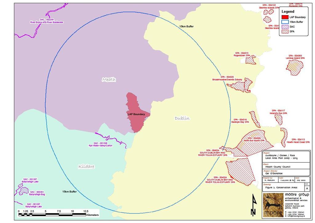
175
Dunboyne/Dunboyne North/ Clonee/ Local Area Plan
 Dunboyne/Dunboyne North/ Clonee/ Local Area Plan Strategic Policy SP 1 To operate an Order of Priority for the release of residential lands in compliance with the requirements of CS OBJ 6 of the County
Variation No. 2 Introduction & Explanatory Document Variation made on 19th May 2014
 Meath County Development Plan 2013 2019 Variation No. 2 Introduction & Explanatory Document Variation made on 19th May 2014 1.0 INTRODUCTION The Meath County Development was adopted on 17 th December
Tāhuhu whakaruruhau ā-taone The sheltering ridge pole
 B2. Tāhuhu whakaruruhau ā-taone - Urban growth and form B2.1. Issues Tāhuhu whakaruruhau ā-taone The sheltering ridge pole Auckland s growing population increases demand for housing, employment, business,
Meath County Development Plan. Variation No. 1 to Volume 1 Written Statement
 Meath County Development Plan 2013 2019 Variation No. 1 to Volume 1 Written Statement 2 Core Strategy Adopted Variation No. 1-04/11/2013 2.3.3 Residential Zoned Land Provision Table 2.4 details the requirement
Plan Modification to Chapter B2 of the Auckland Unitary Plan(AUP) Operative in part (15 November 2016)
 Operative in part (15 November 2016)") UNITARY PLAN UPDATE REQUEST MEMORANDUM TO FROM Phill Reid Linley Wilkinson DATE 25 September 2018 SUBJECT Plan Modification to Chapter B2 of the Auckland Unitary Plan(AUP) Operative in part (15 November
UNITARY PLAN UPDATE REQUEST MEMORANDUM TO FROM Phill Reid Linley Wilkinson DATE 25 September 2018 SUBJECT Plan Modification to Chapter B2 of the Auckland Unitary Plan(AUP) Operative in part (15 November
elbridge Core Strategy
 C elbridge Core Strategy Celbridge is designated as a Moderate Growth Town in the RPGs. The County Development Plan reinforces this designation in its settlement strategy. Moderate Growth Towns within
Meath County Development Plan. Proposed Draft Variation No. 1 to Volume 1 Written Statement
 Meath County Development Plan 2013 2019 Proposed Draft Variation No. 1 to Volume 1 Written Statement 2 Core Strategy Proposed Draft Variation No. 1!" #$ % & ' % $ ($ &' ) $) * (' &+( &' % $ * $ $ * %
EVALUATION OF MASTER PLAN ALTERNATIVES
 7 The Environmental Report is required to identify, describe and evaluate reasonable alternatives, taking into account the objectives and geographical scope of the Master Plan 2008. Three plan alternatives
DUBLIN DOCKLANDS MASTER PLAN AND RELATIONSHIP WITH OTHER PLANS
 .1 National Policy and Programmes.1.1 Sustainable Development A Strategy for Ireland, 1997.1.2 National Climate Change Strategy, 2007-2012.1. National Development Plan 2007-201.1.4 National Spatial Strategy,
Pre Draft Manager s Report Meath County Development Plan TABLE OF CONTENTS
 Pre Draft Manager s Report Meath County Development Plan 2013-2019 TABLE OF CONTENTS Section 1 Introduction and Overview of Pre Draft Consultation Report 1.1 Introduction... 1 1.2 Pre Draft Public Consultation...
Chapter 3 Core Strategy
 Chapter 3 Core Strategy 3.0 Introduction The core strategy sets out how the development objectives in the Development Plan are consistent with the National Spatial Strategy and the Regional Planning Guidelines.
Incorporating Draft Amendment Number 1 Made on 2 nd of March 2015
 Incorporating Draft Amendment Number 1 Made on 2 nd of March 2015 Ratoath Local Area Plan CONTENTS CHAPTER 1 BACKGROUND INFORMATION 1.1 Introduction... 1 1.2 Scope of the Local Area Plan... 2 1.3 Ratoath
Rathmolyon Written Statement
 Settlement Rathmolyon Position in Settlement Hierarchy Village - Local centre for services and local enterprise development Position in Retail Strategy Fourth tier retail centre Population (2011) Census
3.0 Policy Context. 3.1 Introduction. 3.2 National Spatial Strategy, The Role of East Meath under the NSS
 3.0 Policy Context 52 Policy Context 3.0 Policy Context 3.1 Introduction There is an extensive range of strategic guidance and policy for land use planning in Ireland. This has been fully examined in the
Newcourt Masterplan. November Exeter Local Development Framework
 Newcourt Masterplan November 2010 Exeter Local Development Framework Background The Exeter Core Strategy Proposed Submission sets out the vision, objectives and strategy for the development of Exeter up
Strategic Environmental Assessment Screening Report. Dublin Port Masterplan Review 2017
 Strategic Environmental Assessment Screening Report Dublin Port Masterplan Review 2017 Table of Contents 1 Introduction... 1 2 Purpose of the Masterplan... 2 3 Task 1.1 Pre-Screening Check... 5 4 Task
Appendix. Statement Outlining Compliance with Ministerial Guidelines
 18 Appendix Statement Outlining Compliance with Ministerial Guidelines A18 Statement Outlining Compliance with Ministerial Guidelines Under section 28 of the Planning and Development Act 2010, Meath County
Navan 1. Nevinstown 2. Farganstown 3. Liscarton
 Review of Economic Development Sites and Residential Lands regarding the Proposed Variation No. 3 (Phase 3b) for Meath County Council Navan Review of Economic Development Sites regarding the Proposed Variation
I615. Westgate Precinct
 I615. Westgate Precinct I615.1. Precinct Description The Westgate Precinct is located approximately 18km west of the Auckland city centre. There are seven Sub-precincts in the Westgate Precinct: Sub-precinct
Sustainability Statement. Whitby Business Park Area Action Plan
 Sustainability Statement Whitby Business Park Area Action Plan November 2014 Contents Page 1. Introduction 1 2. Scoping 3 3. Sustainability Appraisal of Options 6 4. Assessment of Draft Area Action Plan
Northern Territory Compact Urban Growth Policy
 Northern Territory Compact Urban Growth Policy A Reference Policy Document to clause 2.7 (Reference to Policy) of the NT Planning Scheme May 2015 Table of Contents 1 Policy Setting... 3 1.1 Context for
Ballivor Written Statement
 Settlement Ballivor Position in Settlement Hierarchy Village - Local centre for services and local enterprise development Position in Retail Strategy Fourth tier retail centre Population (2011) Census
Appendix 1 Structure plan guidelines
 Appendix 1 Structure plan guidelines This appendix forms part of the regional policy statement [rps]. 1.1. Introduction Structure plans are an important method for establishing the pattern of land use
Maynooth. Local Area Plan Plean Cheantar Aitiuil Mháigh Nuad. 26th August 2013
 Maynooth Local Area Plan 2013 2019 Plean Cheantar Aitiuil Mháigh Nuad 26th August 2013 Table of Contents PART A Introduction and Context 1.0 Introduction 5 1.1 Local Area Plans Status and Process 6 1.2
ROCHFORD LOCAL DEVELOPMENT FRAMEWORK: Sustainability Appraisal/ Strategic Environmental Assessment. Rochford Core Strategy Preferred Options Document
 ROCHFORD LOCAL DEVELOPMENT FRAMEWORK: Sustainability Appraisal/ Strategic Environmental Assessment Non Technical Summary Rochford Core Strategy Preferred Options Document October 2008 SUSTAINABILITY APPRAISAL
Schedule of Planning Applications Committee Date: 23 May Reference: 06/17/0726/F Parish: Hemsby Officer: Mr J Beck Expiry Date:
 Schedule of Planning Applications Committee Date: 23 May 2018 Reference: 06/17/0726/F Parish: Hemsby Officer: Mr J Beck Expiry Date: 22-05-2018 Applicant: Proposal: Site: Mr Gillett Change of use to the
KELLS DEVELOPMENT PLAN
 KELLS DEVELOPMENT PLAN 2013-2019 J Statement Outlining Compliance with Ministerial Guidelines Adopted 7th October 2013 APPENDIX J STATEMENT OUTLINING COMPLIANCE WITH MINISTERIAL GUIDELINES Under section
Rochford District Council Allocations Development Plan Document: Discussion and Consultation Document Sustainability Appraisal
 Option SWH1 Balanced Communities Option SWH1 1 To ensure the delivery of high quality sustainable communities where people want to live and work Will it ensure the phasing of infrastructure, including
20. Ballysadare Mini-Plan
 20. Ballysadare Mini-Plan 20. Ballysadare Mini-Plan Community facilities Ballysadare has a wide range of community facilities: a primary school, St Mary s College (secondary school), a health centre, playing
Official Plan Review
 Official Plan Review Summary Report - The Built Environment August 2014 Part 1: Introduction Planning for a healthy, prosperous and sustainable community is an important goal for our municipality. From
The Meath County Development Plan will provide the main public statement of planning policies and objectives at county level.
 Meath County Council are delighted to engage in this public consultation process in relation to the review of the Meath County Development Plan 2007-2013 and the preparation of the next County Development
WELCOME GYPSY LANE. Wider Site Location plan. Proposals for the development of LAND OFF FOXLYDIATE LANE WEBHEATH. Proposals for the development of
 WELCOME The developers are preparing an outline planning application for a residential led development and need the community s views in order to develop the proposals further WHAT IS PROPOSED? A high
4 RESIDENTIAL ZONE. 4.1 Background
 4 RESIDENTIAL ZONE 4.1 Background The residential areas within the City are characterised by mainly lowrise dwellings sited on individual allotments. Past architectural styles, settlement patterns and
The Fairfield Partnership Vision for North-East Elsenham
 The Fairfield Partnership Vision for North-East Elsenham August 2009 Frequently Asked Questions Who is The Fairfield Partnership? The Fairfield Partnership is a joint venture between Marchfield Developments
Guidelines for Planning Authorities and Part V of the Planning and Development Act 2000: December 2000
 Slide 1 Slide 2 Slide 3 Slide 4 As a planner in practice, whether within the Local Authority, private practice or An Bord Pleanala, due regard must be given to the guidance provided by the Department in
DAREBIN PLANNING SCHEME AMENDMENT C137
 Who is the planning authority? Planning and Environment Act 1987 DAREBIN PLANNING SCHEME AMENDMENT C137 EXPLANATORY REPORT This amendment has been prepared by the Darebin City Council, who is the planning
Ratthcaiirrn Wrriitttten Sttattementt
 Ratthcaiirrn Wrriitttten Sttattementt Settlement Rathcairn Position in Settlement Hierarchy Village Serve a smaller rural catchment; provide local services with some smaller scale rural enterprises in
Woodbrook - Shanganagh
 Section 4: Key Sites Framework Strategy Woodbrook - Shanganagh Local Area Plan 2017-2023 4. Site Framework Strategies The Master Plans shall have regard to the thematic objectives under the LAP Development
According to planning legislation, there are a number of topics which the development plan objectives must address.
 INTRODUCTION What is a Development Plan? A development plan is a document which details the overall strategy of the council for the proper planning and sustainable development of an area and generally
Chapter 2: OUTLINE PLANNING APPLICATION PROPOSALS. A New Garden Neighbourhood Matford Barton 17
 Chapter 2: OUTLINE PLANNING APPLICATION PROPOSALS A New Garden Neighbourhood Matford Barton 17 2.1. SUMMARY AND STATUS OF THE PROPOSALS 2.1.1. The parameter plans and associated wording in this chapter
3. Neighbourhood Plans and Strategic Environmental Assessment
 1. Introduction This report sets out a draft Screening Determination for the Preston Parish Council s Neighbourhood Plan and has been prepared by rth Hertfordshire District Council. The purpose of the
Circular L8/08 2 September Water Services Investment and Rural Water Programmes Protection of Natural Heritage and National Monuments
 Circular L8/08 2 September 2008 Water Services Investment and Rural Water Programmes Protection of Natural Heritage and National Monuments 1. The purpose of this Circular is to provide local authorities
Regional Context Statement
 Regional Context Statement REGIONAL CONTEXT STATEMENT 3. REGIONAL CONTEXT STATEMENT In 1995, the Provincial Government passed into law the Growth Strategies Act. The purpose of this provincial initiative
8.0 Design and Form of Development 43/
 42/ 8.0 Design and Form of Development 43/ Rothwells Farm, Golborne/ Development Statement Figure 7. Site Constraints Key 44/ Site Boundary 360 Bus Route/Stops Existing Trees Underground Water Pipe Sensitive
The Proposed Auckland Unitary Plan (notified 30 September 2013)
") 3 Business zones Introduction There are 10 business zones in the Unitary Plan: City Centre Metropolitan Centre Town Centre Local Centre Neighbourhood Centre Mixed Use General Business Business Park Light
3 Business zones Introduction There are 10 business zones in the Unitary Plan: City Centre Metropolitan Centre Town Centre Local Centre Neighbourhood Centre Mixed Use General Business Business Park Light
APPROPRIATE ASSESSMENT SCREENING IN ACCORDANCE WITH THE REQUIREMENTS OF ARTICLE 6(3) OF THE EU HABITATS DIRECTIVE FOR THE PROPOSED VARIATION OF THE
 OF THE EU HABITATS DIRECTIVE FOR THE PROPOSED VARIATION OF THE") APPROPRIATE ASSESSMENT SCREENING IN ACCORDANCE WITH THE REQUIREMENTS OF ARTICLE 6(3) OF THE EU HABITATS DIRECTIVE FOR THE PROPOSED VARIATION OF THE DUBLIN CITY DEVELOPMENT PLAN 2011-2017 RANELAGH AVENUE,
APPROPRIATE ASSESSMENT SCREENING IN ACCORDANCE WITH THE REQUIREMENTS OF ARTICLE 6(3) OF THE EU HABITATS DIRECTIVE FOR THE PROPOSED VARIATION OF THE DUBLIN CITY DEVELOPMENT PLAN 2011-2017 RANELAGH AVENUE,
17. Coolaney-Rockfield Mini-Plan
 County Development Plan 2017-2023 Consolidated Draft + Adopted Amendments - August 2017 17. Coolaney-Rockfield Mini-Plan Village profile Coolaney is located approximately 23 km to the south-west of Sligo
2A District-wide Policies
 2A Introduction This Chapter contains policies which are relevant to subdivision, use and development activities occurring across all zones and areas of the District. The policies in this Chapter implement
MOUNT AVENUE MASTERPLAN WORKING DRAFT NOVEMBER 2006
 MOUNT AVENUE MASTERPLAN WORKING DRAFT NOVEMBER 2006 1 1. OVERALL MASTERPLAN IDENTITY: Dun Dealgan motte and bailey The Dun Dealgan motte and bailey, a national monument, is located to the north east of
Parish of Repton NEIGHBOURHOOD DEVELOPMENT PLAN
 Parish of Repton NEIGHBOURHOOD DEVELOPMENT PLAN BASIC CONDITIONS STATEMENT December 2018 CEF 4 Legal Requirements This statement has been produced by the NDP Working Group on behalf of Repton Parish Council
WHITELEY TOWN COUNCIL NORTH WHITELEY DEVELOPMENT SEPTEMBER 2014
 WHITELEY TOWN COUNCIL NORTH WHITELEY DEVELOPMENT SEPTEMBER 2014 Dear Resident This Special Edition of the Whiteley Voice which has been prepared in conjunction with the North Whiteley Consortium is to
Chapter IV: Development Pattern
 Chapter IV: Development Pattern Introduction The 2002 Prince George s County Approved General Plan designates three growth policy tiers Developed, Developing, and Rural as well as three center designations
Great Easton Neighbourhood Plan Statement of Basic Conditions
 Great Easton Neighbourhood Plan 2017-2031 Statement of Basic Conditions OCTOBER 2016 GREAT EASTON PARISH COUNCIL Contents 1.0 Introduction....Page 2 2.0 Summary of Submission Documents and Supporting Evidence..
Site Assessment Technical Document Appendix A: Glossary
 Central Bedfordshire Council www.centralbedfordshire.gov.uk Site Assessment Technical Document Appendix A: Glossary July 2017 1.1.11-1 - ii Appendix A: Glossary Term Agricultural Land Classification AONB
9 CITY OF VAUGHAN OFFICIAL PLAN AMENDMENT NO BOCA EAST INVESTMENTS LIMITED
 9 CITY OF VAUGHAN OFFICIAL PLAN AMENDMENT NO. 631 - BOCA EAST INVESTMENTS LIMITED The Planning and Economic Development Committee recommends the adoption of the recommendations contained in the following
Variation No 1: Dundalk & Environs Development Plan Core Strategy
 Variation No 1: Dundalk & Environs Development Plan 2009-2015 Core Strategy Adopted on 29 th August 2011 CONTENTS Page Section 1 1.0 Synopsis 1 1.1 Background Document 1 1.2 Variation of Dundalk and Environs
Former Rockcliffe Airbase Community Design Plan Guiding Design Vision and Principles December 4, 2013
 APPENDIX 5 - Guiding Design Vision and Principles Former Rockcliffe Airbase Community Design Plan Guiding Design Vision and Principles December 4, 2013 Vision Statement The redevelopment of the former
Edenderry Local Area Plan
 Edenderry Local Area Plan 2017-2023 MATERIAL ALTERATIONS TO DRAFT EDENDERRY LOCAL AREA PLAN Public Display Document Section 1: Introduction 1.1 Introduction This report focuses on the proposed material
Celbridge. Local Area Plan Statement. Planning Department Kildare County Council September 2017
 Celbridge Local Area Plan 2017-2023 Dréachtphlean Ceantair Áitiúil Cill Droichid Planning Department Kildare County Council September 2017 SEA Statement Kildare County Council Celbridge Local Area Plan
2.0 Strategic Context 4
 2.0 Strategic Context 4 2.1 The Area Action Plan is a non-statutory plan, which forms a corporate policy document, expressing particular issues and areas of concern while also providing a vision for the
CONTENTS 8.0 LAND USE 8.1 GENERAL LAND USE 8.2 RESIDENTIAL 8.3 MIXED USE 8.4 COMMERCIAL 8.5 EMPLOYMENT LANDS
 8-2 Land Use 8.0 LAND USE CONTENTS 8.1 GENERAL LAND USE 8.1.1 Uses provided for in all Land Use Designations 8.1.2 Uses prohibited in Hazardous Lands, Hazardous Sites and Special Policy Areas 8.1.3 Uses
Public Consultation. Land at Monks Farm, North Grove. Welcome
 Welcome Welcome to our public exhibition for development on Land at Monks Farm, orth Grove. Gallagher Estates and Gleeson Strategic Land are preparing an outline planning application for new homes, open
YONGE STEELES CORRIDOR SECONDARY PLAN. Young + Wright / IBI Group Architects Dillon Consulting Ltd. GHK International (Canada) Ltd.
 Ltd.") PART A: PREAMBLE 1.0 PURPOSE The purpose of this Secondary Plan is to provide a development framework for intensification of the Yonge/ Steeles corridor including the north side of Steeles Avenue West
PART A: PREAMBLE 1.0 PURPOSE The purpose of this Secondary Plan is to provide a development framework for intensification of the Yonge/ Steeles corridor including the north side of Steeles Avenue West
INCREMENTAL CHANGE AREA REVIEW March 2015 Page 1
 INCREMENTAL CHANGE AREA REVIEW March 2015 Page 1 Table of Contents Introduction... 3 Background to Review... 3 Comparison of the Schedules to the General Residential Zone... 7 Methodology... 7 Policy Context...
14.5 HOPEFIELD: (REFER PLAN 39 AND PLAN 40)
") URBAN DYNAMICS WESTERN CAPE INC. 248 14.5 HOPEFIELD: (REFER PLAN 39 AND PLAN 40) FIGURE 83: LOCALITY - HOPEFIELD Within the context of the Saldanha Bay Municipal area, Hopefield, an historical agricultural
URBAN DYNAMICS WESTERN CAPE INC. 248 14.5 HOPEFIELD: (REFER PLAN 39 AND PLAN 40) FIGURE 83: LOCALITY - HOPEFIELD Within the context of the Saldanha Bay Municipal area, Hopefield, an historical agricultural
DUNSFOLD NEIGHBOURHOOD PLAN Site Selection Policies
 DUNSFOLD NEIGHBOURHOOD PLAN Site Selection Policies The criteria for assessing sites for future housing and business development in Dunsfold are set out below. (Development criteria, covering what it is
TRIM DEVELOPMENT PLAN Volume 1 Written Statement
 TRIM DEVELOPMENT PLAN 2014 2020 Volume 1 Written Statement Table of Contents Trim Development Plan 2014-2020 Volume 1 Written Statement 1 Introduction to the Trim Development Plan 2014-2020. 1 1.1 Introduction...
RURAL ZONE - POLICY. Rural Zone Policy. Issue: Rural Environment. Ruapehu District Plan Page 1 of 8
 Rural Zone Policy RU2 RURAL ZONE - POLICY RU2.1 Introduction The natural resources of the rural environment in the Ruapehu District provide the basis for the existing and potential character, intensity
Draft Eastern District Plan
 Draft Eastern District Plan Submission_id: 31238 Date of Lodgment: 13 Dec 2017 Origin of Submission: Online Organisation name: Turrulla Gardens Pty Ltd C/- Mecone Organisation type: Industry First name:
5 PLANNING ANALYSIS 5.1 THE SITE AND ITS DEVELOPMENT CONTEXT
 5 PLANNING ANALYSIS 5.1 THE SITE AND ITS DEVELOPMENT CONTEXT The Azuri IRS River Villa Complex site is situated on the western margin of Azuri Phase 1, inland. The whole site borders Rivière du Rempart
CORNUBIA RETAIL PARK- PLANNING REPORT REVERT 3
 CORNUBIA RETAIL PARK- PLANNING REPORT 19.04.2013 REVERT 3 1 FOR: BY: 28 DEVONSHIRE AVENUE GLENWOOD DURBAN 4001 P.O. BOX 17390 CONGELLA 4013 T +27 31 202 9550 F +27 31 202 9551 1st FLOOR THE MEDIA MILL
Table of Contents. 3. Name and Location of Natura 2000 sites Description of the Project or Plan 5
 Table of Contents PAGE NUMBER 1. Introduction 1 2. Name of Project or Plan 1 3. Name and Location of Natura 2000 sites 1 4. Description of the Project or Plan 5 5. Is this Project or Plan directly connected
INTRODUCTION NORTH HEYBRIDGE GARDEN SUBURB
 INTRODUCTION This event is being hosted by the promoters of the proposed North Heybridge Garden Suburb who are working with Maldon District Council and other key stakeholders on the preparation of a comprehensive
Kilmessan Written Statement
 Settlement Kilmessan Position in Settlement Hierarchy Village - Local centre for services and local enterprise development Position in Retail Strategy Fourth tier retail centre Population (2011) Census
Appendix A: Retail Planning Assessment
 Rotherham Town Centre Masterplan Appendix A: Retail Planning Assessment 139 Appendix A Rotherham Town Centre Masterplan Retail Planning Background and Policy Context 1. Introduction 1.1 The Masterplan
WATERLOO STATE SIGNIFICANT PRECINCT SUMMARY OF STUDIES
 WATERLOO STATE SIGNIFICANT PRECINCT SUMMARY OF STUDIES Technical studies will be undertaken to inform the master planning process for the Waterloo precinct to develop a Precinct Proposal to redevelop the
Complete Neighbourhood Guidelines Review Tool
 Complete Neighbourhood Guidelines Review Tool Prepared By: City of Regina Planning Department October 2014 Page 1 of 14 Community Development Review Checklist for Secondary Plans and Concept Plans The
Page 1 of 19 URBAN DESIGN FRAMEWORK FOR BOLTON STREET WATERFORD
 Page 1 of 19 URBAN DESIGN FRAMEWORK FOR BOLTON STREET WATERFORD 1.0 Introduction: The relocation of the City Council stores and depot from Bolton Street creates an exciting opportunity for development
A Growing Community Rural Settlement Areas
 Town of Huntsville Official Plan Review - POLICY BACKGROUND PAPER A Growing Community Rural Settlement Areas BACKGROUND: In addition to the fully municipally-serviced Urban Settlement Area and the Hidden
Employment and Commercial Review Analysis of Policy Directions
 Employment and Commercial Review Analysis of Policy Directions Appendix A The following analysis is town staff s response to the policy directions provided by the consultants who prepared the Employment
and also to consider how Luas Line A1 will contribute to good planning and sustainable development in the area it serves.
 .0 PLANNING AND POLICY CONTEXT.1 INTRODUCTION The purpose of this chapter is to provide some relevant background information in relation to planning and transport policy under the following headings: Background
Boyne Valley to Lakelands County Greenway. Feasibility Report. Navan Kingscourt Railway Committee
 Boyne Valley to Lakelands County Greenway Feasibility Report Navan Kingscourt Railway Committee June 2013 Quality Control Issue/revision Issue 1 Revision 1 Remarks DRAFT FINAL Date April 2013 June 19 th
and services The protection and conservation of environmentally significant and sensitive natural heritage features and functions.
 6. Land Use 6.0 Preamble A healthy and livable city is one in which people can enjoy a vibrant economy and a sustainable healthy environment in safe, caring and diverse neighbourhoods. In order to ensure
Ipswich Issues and Options for the Ipswich Local Plan Review, August 2017, Public Consultation
 Ipswich Issues and Options for the Ipswich Local Plan Review, August 2017, Public Consultation Having reviewed the issues and options documents, the Society has made the following response: Part 1 Strategic
Welcome to our exhibition
 Welcome to our exhibition The Homes & Communities Agency (HCA) welcomes you to this public exhibition explaining our proposals for the redevelopment of the former Lea Castle Hospital site. About the Homes
WELCOME. Land North of STEVENAGE. We would like to thank you for attending our public exhibition today.
 WELCOME We would like to thank you for attending our public exhibition today. The purpose of this event is to share our proposals and hear your thoughts on our ideas. Members of the project team are on
SHORELINE, FLOOD AND COASTAL DEFENCE MANAGEMENT PLANS
 These plans may provide opportunities as well as concern for recreational boating. They are currently being revised and consulted on. This document explains how we can engage in the process. Shoreline,
28. Coolaney-Rockfield Mini-Plan
 28. Coolaney-Rockfield Mini-Plan 28. Coolaney-Rockfield Mini-Plan Community facilities Community facilities in Coolaney-Rockfield consist of a primary school, crèche, community centre, sports field and
NOVEMBER 2013 CARRICK ON SUIR TOWN DEVELOPMENT PLAN Carrick on Suir Town Council
 NOVEMBER 2013 CARRICK ON SUIR TOWN DEVELOPMENT PLAN 2013 Carrick on Suir Town Council Effective from the 26 th November 2013 TABLE OF CONTENTS Table of Figures... 6 List of Tables... 7 Schedule of Policies...
FORMER CANADIAN FORCES BASE (CFB) ROCKCLIFFE SECONDARY PLAN. Official Plan Amendment XX to the Official Plan for the City of Ottawa
 ROCKCLIFFE SECONDARY PLAN. Official Plan Amendment XX to the Official Plan for the City of Ottawa") FORMER CANADIAN FORCES BASE (CFB) ROCKCLIFFE SECONDARY PLAN Official Plan Amendment XX to the Official Plan for the City of Ottawa 1 INDEX THE STATEMENT OF COMPONENTS PART A THE PREAMBLE PAGE Purpose...
FORMER CANADIAN FORCES BASE (CFB) ROCKCLIFFE SECONDARY PLAN Official Plan Amendment XX to the Official Plan for the City of Ottawa 1 INDEX THE STATEMENT OF COMPONENTS PART A THE PREAMBLE PAGE Purpose...
13 FUTURE DEVELOPMENT AND STRUCTURE PLANS
 13 FUTURE DEVELOPMENT AND STRUCTURE PLANS Contents 13.1 Introduction 13.2 Resource Management Issues 13.3 Objectives 13.4 Policies 13.5 Strategy 13.6 Implementation 13.6.1 District Plan Regulatory Methods
K. SMART ASSOCIATES LIMITED
 Planning Justification Report Zoning By-Law Amendment 185 King Street North Waterloo, Ontario April 7th, 2017 Project Reference Number 16-245 K. SMART ASSOCIATES LIMITED CONSULTING ENGINEERS AND PLANNERS
Local Development Scheme
 Local Development Scheme 2012 2016 The Local Development Scheme (LDS) is a project plan that outlines how and when the Authority will update its planning policies and other associated documents. It ensures
Chapter 2 Core Strategy
 Chapter 2 Core Strategy 11-24 2.1 Introduction 2.2 Strategic Planning Approach 2.3 Growth Consistency with the National Spatial Strategy & Regional Planning Guidelines 2.1 Introduction The overall strategy
MAYFIELD WEST SECONDARY PLAN PHASE 2
 MAYFIELD WEST SECONDARY PLAN PHASE 2 Public Open House #3 February 25, 2010 Draft Preferred Land Use Scenario TOWN OF CALEDON PLANNING & DEVELOPMENT DEPARTMENT Open House Agenda TOWN OF CALEDON 1. Welcome
Evaluation of Plan Provisions
 Section 8 Evaluation of Plan Provisions 8.1 Methodology This section evaluates the provisions of the Plan. The description of the environmental baseline together with the maps provided in Section 4 of
TIDAPA Structure Plan
 TIDAPA Structure Plan Prepared by Tract Consultants 28 MARCH 2017 0217-0074 Table of Contents 01 STRATEGIC CONTEXT Executive Summary Regional Context Page 3 Page 4 02 LOCAL CONTEXT Aerial Photograph Local
Appendix A. Planning Processes. Introduction
 1 Planning Processes Introduction This appendix outlines a number of planning processes which are used in the Auckland Region to support the effective management of development in the region s rural and
Drrumconrratth Wrriitttten Sttattementt. Position in Settlement Hierarchy Village - Local centre for services and local enterprise development
 Drrumconrratth Wrriitttten Sttattementt Settlement Drumconrath Position in Settlement Hierarchy Village - Local centre for services and local enterprise development Position in Retail Strategy Level 4
1.0 Purpose of a Secondary Plan for the Masonville Transit Village
 Report to Planning and Environment Committee To: Chair and Members Planning & Environment Committee From: John M. Fleming Managing Director, Planning and City Planner Subject: Masonville Transit Village