30. Riverstown Mini-Plan
|
|
|
- Alberta Miller
- 6 years ago
- Views:
Transcription
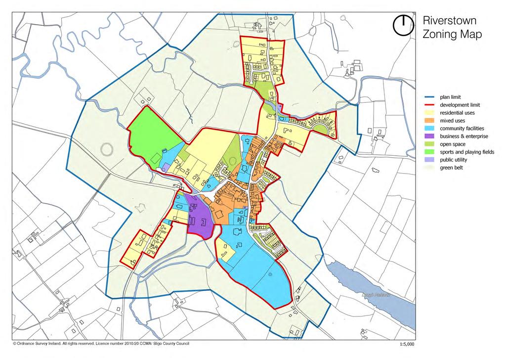
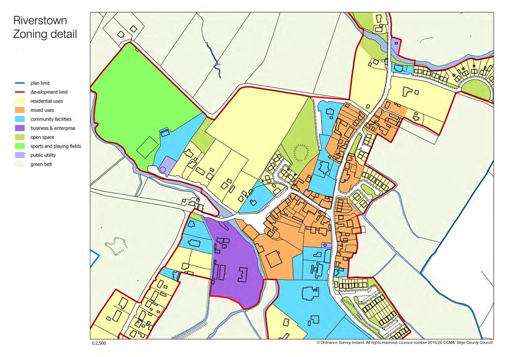
1 County Development Plan Consolidated Draft + Adopted Amendments August 2017 Volume 2, Chapter 30 Riverstown Mini-Plan 30. Riverstown Mini-Plan Village profile Riverstown is located approximately 20 km to the south of Sligo City, in a designated Rural Area in Need of Regeneration. The village provides a range of important services for the population of the wider rural area. The Douglas River (SAC / NHA) flows to the north of the village, the Arrow / Unshin River (SAC / NHA) flows to the west, and to the east there is Lough Meharth (NHA). These natural amenities are of particular heritage value to the village. The old village core is focused along Main Street and the local road which runs west to connect with the N-4. The village core consists mainly of terraced buildings mixed with some new residential and commercial structures. Development in recent years has been located close to the village centre. In the County settlement hierarchy, Riverstown is designated as a village sustaining the rural community (see Section 3.2 of this Plan). Population and housing According to 2011 Census information, Riverstown had a population of 374 persons in 2011 (21 % higher than the 2006 population). The population had already risen by 13.5% between the years 2002 and A survey carried out by Council planners in 2015 estimated a population of 442 persons based on a total of 170 occupied houses within the development limit. Census 2016 recorded a population of 334 persons in Riverstown. More recent growth in residential development is largely attributable to the Rural Renewal Tax Incentive Scheme and the attractive setting of the village. New housing has taken the form of suburban-type estates. The 2015 survey found a residential vacancy rate of 9% (17 units), down from a rate of 12% (20 units) in It is considered that there is only limited need for additional residential development during the plan period. Community facilities There is a good range of community facilities in Riverstown: two primary schools, a playschool, a playground, two churches, a community hall and two playing pitches with associated dressing rooms. The village is also served by a Garda Station, doctor s surgery and health centre. Recent population growth may result in demands for additional community facilities. While some lands have been zoned for these specific purposes, a flexible approach should be taken towards proposals for community developments on other suitable sites. 1
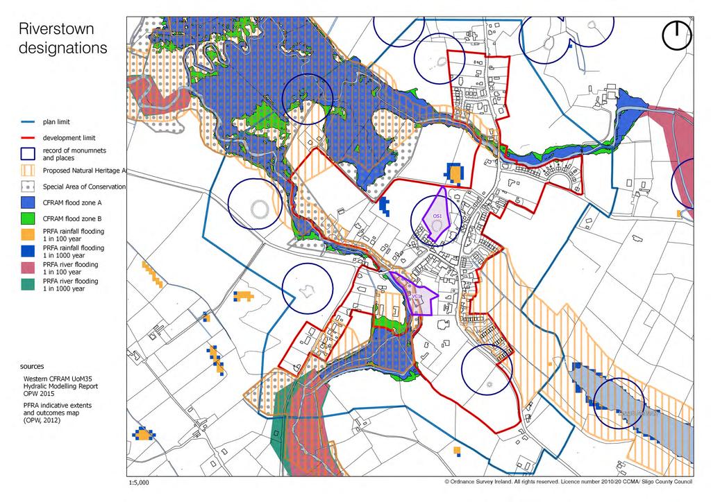
2 County Development Plan Consolidated Draft + Adopted Amendments August 2017 Volume 2, Chapter 30 Riverstown Mini-Plan Commercial and enterprise development Riverstown plays an important role as a retail provider for the surrounding rural community. Retail development in the form of small convenience outlets is focused along Main Street and in the village core. The Homeland Co-Op shop provides a valuable service to the wider farming community. Its continued development is important for the vitality of the village centre. The Folk Park and the Morrison Centre are Riverstown s cultural and tourist attractions. A supportive approach should be adopted to promote their continued use and future growth. Infrastructure Riverstown is served by a network of local roads, one of which runs west of the village to connect with the N4 Sligo-Dublin road (approximately 3 km away). The water supply is sourced from a well bore adjacent to Lough Arrow. The wastewater treatment plant has a design capacity of 600PE (population equivalent). Objectives Note: These objectives must be considered in conjunction with the policies and objectives contained in Volume 1 and the general policies for mini-plans contained in Chapter 1 of Volume 2 of this Plan. It is an objective of Sligo County Council to: 30.1 Natural heritage and open space A. Encourage the protection and enhancement of the conservation value of Unshin River SAC / pnha (including part of the Douglas River) and Lough Meharth pnha. B. Encourage improved access to Unshin River and Douglas River by providing walkways as indicated on the Objectives Map and by requiring their provision in conjunction with the development of adjoining lands, subject to Habitats Directive Assessment. C. Reserve land for a public park on site OS-1. The park should be developed as a semi-natural open space area and should protect and highlight the archaeological integrity of the site. Pedestrian links should be provided to adjoining lands and Main Street. 2
3 County Development Plan Consolidated Draft + Adopted Amendments August 2017 Volume 2, Chapter 30 Riverstown Mini-Plan 30.2 Built heritage A. Seek the protection and conservation of the following Protected Structures located within the plan limit: RPS-18 RPS-19 RPS-20 RPS-21 Bridge spanning the Douglas River, Ardcumber Td/Ardkeeran Td, Riverstown Riverstown National School, Ardkeeran, Riverstown Millview House, Ardkeeran, Riverstown Church of the Sacred Heart (RC), Ardkeeran, Riverstown RPS-156 Riverstown Garda Station, Cooperhill, Riverstown RPS-157 Cooper Memorial Hall, Cooperhill, Riverstown RPS-158 Tawnagh Church (CoI), Cooperhill, Riverstown RPS-159 Bridge spanning Unshin River, Cooperhill/ Td/Ardkeeran Td, Riverstown RPS-170 Kingsville House, Cuiltylough, Riverstown B. Require any development proposal involving a Building of Note (as indicated on the Objectives Map) to restore or renovate the building in a sensitive manner that will contribute to the preservation and enhancement of the character of the building and its setting. C. Ensure that new development within the village centre reflects and enhances the existing streetscape character in accordance with the policies set out in Chapter 12 (Urban design) and the requirements of Section Development in historic streetscapes (development management standards) of this Plan. D. The Objectives Map identifies key sites or structures that have potential or already contribute to the village character by closing a view or containing a space. These sites and structures should be redeveloped or renovated with particular attention to design, having regard to their location, so that they enhance the streetscape and act as focal points or landmarks Circulation and parking A. Support the provision of pedestrian links between the village and surrounding natural amenities, whilst also connecting with the Folk Park and community facilities (as shown on the Objectives Map). The provision of such links will be required in conjunction with the development of adjoining lands, and shall be subject to Habitats Directive Assessment and the maintenance of the river buffer Village-centre mixed-use zone A. Require any redevelopment of the existing commercial development at VC-1 to create a strong building line which shall define a public square to the front of the site. Car parking shall be located to the rear of the buildings. 3
4 County Development Plan Consolidated Draft + Adopted Amendments August 2017 Volume 2, Chapter 30 Riverstown Mini-Plan 30.5 Community facilities A. Facilitate the relocation of St Joseph s National School to a larger site on lands zoned for community facilities to the south of the village. B. Encourage the maintenance and enhancement of the existing sports grounds and associated facilities Residential development A. Retain the existing mature trees and stone wall along the eastern boundary of the residential site opposite Kingsville House. B. Any redevelopment of the above site should incorporate well-designed open spaces at the junction of public roads at the south of the site and along the riverside to the north of the site Business and enterprise A. Encourage the maintenance and enhancement of the Folk Park as a tourist attraction. B. Facilitate the development of additional tourism-related local enterprise initiatives Wastewater treatment A. Retain and enhance existing landscaping at the site of the wastewater treatment works. B. A buffer zone shall apply in the vicinity of the existing WWTP site. Development within this zone may be restricted or prohibited in the interest of public health and the protection of residential amenities. The extent of development restrictions in each case will be assessed at planning application stage Flood risk management A. OPW flood risk mapping indicates a potential risk of fluvial (river) flooding on part of the Folk Park site (see the Designations map for more details). Any significant redevelopment of this site shall accompanied by a site-specific Flood Risk Assessment appropriate to the type and scale of the development being proposed. 4


5 County Development Plan Consolidated Draft + Adopted Amendments August 2017 Volume 2, Chapter 30 Riverstown Mini-Plan Buildings of Note BoN No. 1 Five-bay, two-storey building Architecturally valuable features - roof pitch; chimneys on ridge of roof; - vertical-emphasis windows; random rubble stone walling; arched entrance. This building occupies a prominent position at the south-eastern entrance to the village and has interesting features, which add character to the streetscape. Recommendation: The replacement of the windows with timber sliding sash windows would greatly enhance the character of this building. BoN No. 2 Eight-bay, two-storey public house Architecturally valuable features - roof pitch; chimneys on ridge of roof; - original sash windows on upper floors; - decorative but simple plaster work on the façade. This imposing building is an important component of the vernacular streetscape of Riverstown. Recommendation: The replacement of the ground floor windows with a type appropriate to the age of the building would enhance its character. Any expansion of the commercial use of this building must be treated sensitively in terms of the elements mentioned above and in terms of its intrinsic character. BoN No. 3 Five-bay, two-storey public house Architecturally valuable features - roof pitch; decorative chimneys on ridge of roof; vertical-emphasis windows; - ashlar facade. Although much modified, this building, which is defined by its striking chimneys, is an imposing presence on the streetscape. Recommendation: The replacement of the upvc windows with timber sliding sash windows would greatly enhance the character of this building. Any expansion of the commercial use of this building must be treated sensitively in terms of the elements mentioned above and in terms of its intrinsic character. 5
6
7
8
9
10
6. Ballintogher Mini-Plan
 County Development Plan 2017-2023 Consolidated Draft + Adopted Amendments August 2017 Volume 2, Chapter 6 Ballintogher Mini-Plan 6. Ballintogher Mini-Plan Village profile Ballintogher is located approximately
17. Coolaney-Rockfield Mini-Plan
 County Development Plan 2017-2023 Consolidated Draft + Adopted Amendments - August 2017 17. Coolaney-Rockfield Mini-Plan Village profile Coolaney is located approximately 23 km to the south-west of Sligo
County Development Plan Consolidated Draft + Adopted Amendments August 2017 Volume 2, Chapter 22 Easky Mini-Plan
 22. Easky Mini-Plan Village profile Easky is a coastal settlement located approximately 40 km to the west of Sligo City, in a designated Rural Area In Need of Regeneration. The nearby coastline is designated
16. Collooney Mini-Plan
 16. Collooney Mini-Plan Village profile Collooney is located approximately 13 km to the south of Sligo City, in a designated Rural Area under Urban Influence. The village provides a range of services for
20. Ballysadare Mini-Plan
 20. Ballysadare Mini-Plan 20. Ballysadare Mini-Plan Community facilities Ballysadare has a wide range of community facilities: a primary school, St Mary s College (secondary school), a health centre, playing
28. Coolaney-Rockfield Mini-Plan
 28. Coolaney-Rockfield Mini-Plan 28. Coolaney-Rockfield Mini-Plan Community facilities Community facilities in Coolaney-Rockfield consist of a primary school, crèche, community centre, sports field and
35. Gorteen Mini-Plan
 35. Gorteen Mini-Plan 35. Gorteen Mini-Plan Community facilities Community facilities in Gorteen consist of a crèche, community centre, sports field, church, burial ground and health centre. The former
CLOUGHJORDAN SETTLEMENT PLAN
 CLOUGHJORDAN SETTLEMENT PLAN 1.0 General Introduction and Development Context Location The market town of Cloughjordan lies close to the border with Offaly at the junction of the R490 and R491 Regional
Drrumconrratth Wrriitttten Sttattementt. Position in Settlement Hierarchy Village - Local centre for services and local enterprise development
 Drrumconrratth Wrriitttten Sttattementt Settlement Drumconrath Position in Settlement Hierarchy Village - Local centre for services and local enterprise development Position in Retail Strategy Level 4
BORRISOKANE SETTLEMENT PLAN
 BORRISOKANE SETTLEMENT PLAN 1.0 General Introduction and Development Context Location Borrisokane is located 15km north of Nenagh on the N52. While the town is primarily residential, it acts as a market
32. Strandhill Mini-Plan
 32. Strandhill Mini-Plan Village profile Strandhill is located 8 km to the west of Sligo city, on the western extremity of the Coolera Peninsula. The village extends along the north-western foothills of
Rathmolyon Written Statement
 Settlement Rathmolyon Position in Settlement Hierarchy Village - Local centre for services and local enterprise development Position in Retail Strategy Fourth tier retail centre Population (2011) Census
Ballivor Written Statement
 Settlement Ballivor Position in Settlement Hierarchy Village - Local centre for services and local enterprise development Position in Retail Strategy Fourth tier retail centre Population (2011) Census
elbridge Core Strategy
 C elbridge Core Strategy Celbridge is designated as a Moderate Growth Town in the RPGs. The County Development Plan reinforces this designation in its settlement strategy. Moderate Growth Towns within
Clonard Written Statement
 Settlement Clonard Position in Settlement Hierarchy Village - Local centre for services and local enterprise development Position in Retail Strategy Fourth tier retail centre Population (2011) Census 339
Page 1 of 19 URBAN DESIGN FRAMEWORK FOR BOLTON STREET WATERFORD
 Page 1 of 19 URBAN DESIGN FRAMEWORK FOR BOLTON STREET WATERFORD 1.0 Introduction: The relocation of the City Council stores and depot from Bolton Street creates an exciting opportunity for development
Lancaster Conservation Area Appraisal. Character Area 8. Cathedral
 Lancaster Conservation Area Appraisal Character Area 8. Cathedral March 2013 118 3.8 Character Area 8. Cathedral 3.8.1. Definition of Special Interest "This character area is distinctive for the fine group
Proposed Amendment to the
 Proposed Amendment to the Carrigaline Electoral Area Local Area Plan Amendment No 1: Carrigaline (T-02, O-02 & U-02) August 2012 Proposed Amendment to the Carriagline Electoral Area Local Area Plan 2011
Kilmessan Written Statement
 Settlement Kilmessan Position in Settlement Hierarchy Village - Local centre for services and local enterprise development Position in Retail Strategy Fourth tier retail centre Population (2011) Census
Carnaross Written Statement
 Ca n rrnarrossss W t rriittten Sttattementt Settlement Position in Settlement Hierarchy Position in Retail Strategy Population (2011) Geodirectory (No census data available) Committed Housing Units (Not
4 RESIDENTIAL ZONE. 4.1 Background
 4 RESIDENTIAL ZONE 4.1 Background The residential areas within the City are characterised by mainly lowrise dwellings sited on individual allotments. Past architectural styles, settlement patterns and
Drrumcconrratth Wrriitttten Sttattementt. Position in Settlement Hierarchy Village - Local centre for services and local enterprise development
 Drrumcconrratth Wrriitttten Sttattementt Settlement Drumconrath Position in Settlement Hierarchy Village - Local centre for services and local enterprise development Position in Retail Strategy Level 4
SUBMISSION TO DRAFT FINGAL COUNTY DEVELOPMENT PLAN RE: LANDS AT CASTLEKNOCK VILLAGE CENTRE
 April 2016 SUBMISSION TO DRAFT FINGAL COUNTY DEVELOPMENT PLAN 2017-2023 RE: LANDS AT CASTLEKNOCK VILLAGE CENTRE On behalf of: Lidl Ireland GmbH Submitted to: Planning & Strategic Infrastructure Department
Crossakiel Written Statement
 Crrossssakiiell Wrriittten tt Sttattementt Settlement Crossakiel Position in Settlement Hierarchy Village - Local centre for services and local enterprise development Position in Retail Strategy Third
Schedule of Planning Applications Committee Date: 23 May Reference: 06/17/0726/F Parish: Hemsby Officer: Mr J Beck Expiry Date:
 Schedule of Planning Applications Committee Date: 23 May 2018 Reference: 06/17/0726/F Parish: Hemsby Officer: Mr J Beck Expiry Date: 22-05-2018 Applicant: Proposal: Site: Mr Gillett Change of use to the
stakeholders Zoning Conservation Connections
 4.7.1 Zoning The Phoenix Park site is identified as an important gateway site to the city. The site should be developed as a landmark public building with office or cultural use. The present zoning, Z9,
Overview Report. Proposed Development
 Overview Report Proposed Development the construction of a 1km cycle/pedestrian trail including a new footbridge, new car park and entrance road at Drumshanbo Lock and a new pedestrian/cycle road crossing,
Chapter 2: OUTLINE PLANNING APPLICATION PROPOSALS. A New Garden Neighbourhood Matford Barton 17
 Chapter 2: OUTLINE PLANNING APPLICATION PROPOSALS A New Garden Neighbourhood Matford Barton 17 2.1. SUMMARY AND STATUS OF THE PROPOSALS 2.1.1. The parameter plans and associated wording in this chapter
Kildalkey Written Statement
 Settlement Kildalkey Position in Settlement Hierarchy Village - Local centre for services and local enterprise development Position in Retail Strategy Fourth tier retail centre Population (2011) Census
WELCOME. Land North of STEVENAGE. We would like to thank you for attending our public exhibition today.
 WELCOME We would like to thank you for attending our public exhibition today. The purpose of this event is to share our proposals and hear your thoughts on our ideas. Members of the project team are on
Purpose of the Variation: The purpose of an ACA is to protect and enhance the special character of the ACA by:
 To the Lord Mayor and Report No. 202/2017 Members of Dublin City Council Report of the Assistant Chief Executive Proposed Draft Variation (No. 2) of Dublin City Development Plan 2016 2022 Designating Hollybrook
3.3. Urban Structure Defining a New Hierarchy of Routes and Spaces >Images
 Section 3.0 I The Masterplan Framework 18 >Images Examples of high quality routes and spaces 3.3. Urban Structure The success of any masterplan lies in a clear definition of the future urban structure
WELCOME. ORPINGTON. Welcome to this exhibition of our proposals for the redevelopment of Bassetts Campus.
 WELCOME Welcome to this exhibition of our proposals for the redevelopment of Bassetts Campus. The site has been vacant since 2013 and in 2014 NHS Property Services previously brought forward plans for
Downtown Streetscape Manual & Built Form Standards
 City of Guelph Downtown Streetscape Manual & Built Form Standards July 2014 Prepared by Brook McIlroy Inc. in association with Unterman McPhail Associates and McCormick Rankin Inc. City of Guelph Downtown
6 Site Framework Strategies
 6 Site Framework Strategies 6.1 Introduction Section 6 identifies a number of specific areas which are considered to be key sites within the Plan area and which may have potential for development / redevelopment.
Ratthcaiirrn Wrriitttten Sttattementt
 Ratthcaiirrn Wrriitttten Sttattementt Settlement Rathcairn Position in Settlement Hierarchy Village Serve a smaller rural catchment; provide local services with some smaller scale rural enterprises in
heuston gateway: sections heuston gateway: regeneration strategy and development framework plan
 B B1 A B1 B C A heuston gateway: sections B B1 C 117 4.3.3 Zoning The station is the central hub of the area and this function must be preserved and developed. However large areas of the Heuston Station
CORK County Development Plan 2003
 3 VOLUME 3 Specific Zoning Main Settlements Zoning Main Settlements Contents of Volume 3 Settlement 1: BALLINCOLLIG TEXT MAP Settlement 2: BANDON TEXT MAP Settlement 3: BANTRY TEXT MAP Volume 1: Overall
GREENFORD HALL & ADJOINING LAND
 GREENFORD HALL & ADJOINING LAND CONTENTS 1. Introduction 1. Introduction 2. Urban Context 2.1 The Site and Surroundings 2.2 Urban Context Map 2.3 Access and Movement 3. Planning Context 3.1 Planning History
STRENSALL RAILWAY BUILDINGS CONSERVATION AREA APPRAISAL. In association with Strensall with Towthorpe Parish Council
 STRENSALL RAILWAY BUILDINGS CONSERVATION AREA APPRAISAL In association with Strensall with Towthorpe Parish Council CONTENTS Page 1 Introduction 2 2 Location and Context 3 3 Topography and Setting 4 4
Longwood Written Statement
 Settlement Longwood Position in Settlement Hierarchy Village - Local centre for services and local enterprise development Position in Retail Strategy Fourth tier retail centre Population (2011) Census
2. Aughrim Town Plan. Wicklow County Development Plan Context. Level 5 Town Plans Aughrim
 2. Aughrim Town Plan 2.1 Context Aughrim is a small attractive town in south County Wicklow. It lies in a scenic valley where the Ow and Derry rivers meet to form the. The town is on the R747 regional
Camberwell Camberwell Area Vision Map
 Area Vision Map NSP23 Burgess Park Edmund Street NSP29 NSP30 NSP31 New Road Benhill Road NSP27 NSP33 Green Brunswick Park NSP22 station NSP24 Peckham Road NSP26 St Giles Church Lucas Gardens NSP28 NSP25
Carlanstown Written Statement
 Settlement Carlanstown Position in Settlement Hierarchy Village - Local centre for services and local enterprise development Position in Retail Strategy Fifth tier retail centre Population (2011) Census
About 10% of the Borough's population lives in the seven rural parishes. Population figures from the 1991 census are given below:-
 8. THE DISTRICT VILLAGES 8.1 Population About 10% of the Borough's population lives in the seven rural parishes. Population figures from the 1991 census are given below:- Village No. of Persons Cottingham
Easkey. Strandhill Dromore West Ransboro Enniscrone. Tourlestraun. Aclare
 Chapter 12. MAPS Mullaghmore Mullaghmore Cliffony Grange Carney Drumcliff Rathcormack Rosses Point Ballincar Easkey SLIGO Strandhill Dromore West Ransboro Enniscrone Ballysadare Ballintogher Collooney
Statement of Community Involvement LAND OFF SOUTHDOWN ROAD HORNDEAN, HAMPSHIRE
 LAND OFF SOUTHDOWN ROAD HORNDEAN, HAMPSHIRE CONTENTS Page 1. Introduction 3 2. Pre-application Discussions 4 3. The Consultation Process 5 4. Consultation Feedback 7 5. Responses to Consultation Feedback
DESIGN & ACCESS STATEMENT
 DESIGN & ACCESS STATEMENT January 2016 Contents Introduction section 1 Section 1 - Introduction Section 2 - Assessment Section 3 - Involvement Section 4 - Evaluation Section 5 - Design Section 6 - Layout
Woodbrook - Shanganagh
 Section 4: Key Sites Framework Strategy Woodbrook - Shanganagh Local Area Plan 2017-2023 4. Site Framework Strategies The Master Plans shall have regard to the thematic objectives under the LAP Development
STATEMENT OF OBJECTION TO THE PROPOSED DEVELOPMENT OF LAND AT CHURCH CLIFF DRIVE FILEY
 STATEMENT OF OBJECTION TO THE PROPOSED DEVELOPMENT OF LAND AT CHURCH CLIFF DRIVE FILEY You will be aware that Scarborough borough council have adopted a new local plan that includes land at Church Cliff
Welford-on-Avon Neighbourhood Plan Consultation Event Sunday, 6 April Your name Your address
 Welford-on-Avon Neighbourhood Plan Consultation Event Sunday, 6 April 2014 Your name Your email address Please either: - complete this feedback form and put it in the box before leaving the Memorial Hall
Draft Submission of Chilcompton Parish Council to Mendip Local Plan
 Draft Submission of Chilcompton Parish Council to Mendip Local Plan Note: This is a draft for consultation. The Parish Council urges all villagers and other stakeholders to send comments to: parishclerk@chilcompton.org.
Derry City and Strabane District Council Planning Committee Report
 Derry City and Strabane District Council Planning Committee Report COMMITTEE DATE: 23 rd March 2016 APPLICATION No: APPLICATION TYPE: PROPOSAL: LOCATION: APPLICANT: LA11/2015/0395/F Residential Development
3.1 The hybrid planning application proposes the following description of development:
 CHAPTER 3: PROPOSED DEVELOPMENT 3.1 The hybrid planning application proposes the following description of development: Hybrid (part-outline/part-full) planning application for a single composite development
PART AOTEA PRECINCT
 CONTENTS... PAGE AOTEA PRECINCT...4 14.5.1 INTRODUCTION...4 14.5.2 RESOURCE MANAGEMENT ISSUES...4 14.5.3 RESOURCE MANAGEMENT OBJECTIVES AND POLICIES... 4 14.5.4 RESOURCE MANAGEMENT STRATEGY...5 14.5.5
Summerhill Written Statement
 Settlement Summerhill Position in Settlement Hierarchy Village - Local centre for services and local enterprise development Position in Retail Strategy Fourth tier retail centre Population (2011) Census
Site ref: AS06 Site Name or Address: Murreys Court, Agates Lane
 Site ref: AS06 Site Name or Address: Murreys Court, Agates Lane Proposed Land Use: Total Site Area (Ha): Housing 1.85 Ha Description: It is understood that the owner has no plans to dispose of the site
Purpose of the Variation: The purpose of an ACA is to protect and enhance the special character of the ACA by:
 To the Lord Mayor and Report No. 201/2017 Members of Dublin City Council Report of the Assistant Chief Executive Proposed Draft Variation (No. 1) of Dublin City Development Plan 2016 2022 Designating Haddon
Appendix. Statement Outlining Compliance with Ministerial Guidelines
 18 Appendix Statement Outlining Compliance with Ministerial Guidelines A18 Statement Outlining Compliance with Ministerial Guidelines Under section 28 of the Planning and Development Act 2010, Meath County
9 Pershore. Introduction. Pershore Abbey
 118 Introduction 9.1 The historic town of Pershore lies on the River Avon and has a population of 7,000 (2009 Mid-Term Population Estimates). The main areas of the town are centred on the Abbey, the bustling
2bPlanning Scheme. Appendix. Conservation - Removal of Structures. Grangegorman
 Appendix 2bPlanning Scheme Grangegorman Conservation - Removal of Structures Innovative Urban Quarter Contemporary Healthcare Facilities Modern Education Hub Accessible Public Spaces Appendix 2b: Purpose
What do you like about South Marston?
 What do you like about South Marston? What you have said so far: Strong and separate identity, distinct from Swindon Village character (Church, School, Green and Hall) Surrounding working countryside and
Welcome to our Public Consultation
 About our development This exhibition gives you the chance to view and comment on our emerging plans for a proposed residential development located on land to the West of Alwyn Road, Rugby. Welcome to
INTRODUCTION. Land south of Bishopswood Lane, Tadley
 0 INTRODUCTION THE SITE Introduction Gladman Developments Ltd. has successfully invested in communities throughout the UK over the past 0 years, developing high quality and sustainable residential, commercial
Chapter 3 Core Strategy
 Chapter 3 Core Strategy 3.0 Introduction The core strategy sets out how the development objectives in the Development Plan are consistent with the National Spatial Strategy and the Regional Planning Guidelines.
Glossary of Terms. 430 Kildare County Development Plan Kildare County Development Plan
 Glossary of Terms 430 431 Glossary of Terms Appropriate Assessment A requirement to consider the possible nature conservation implications of any plan or project on the Natura 2000 site network before
Welcome to our public exhibition
 About Our Scheme Welcome to our public exhibition This exhibition gives you the chance to view and comment upon our emerging proposals for a new residential development of 68 new homes on the site of the
Stamullen Written Statement
 Settlement Stamullen Position in Settlement Hierarchy Small Town local commuter town situated close to larger centres. Position in Retail Strategy Level 4 retail centre Population (2011) Census 3,130 Committed
1.0 INTRODUCTION. Brantham Industrial Area Regeneration - Factory Lane - Brantham
 1.0 INTRODUCTION Welcome to this exhibition of our proposals for the regeneration of the Brantham Industrial Area located off Factory Lane in Brantham. This presentation will give you an opportunity to
Ensure that development within the Arrowtown Urban Growth Boundary provides:
 URBAN DEVELOPMENT 4 4.2.5.2 Ensure that development within the Arrowtown Urban Growth Boundary provides: an urban form that is sympathetic to the character of Arrowtown, including its scale, density, layout
Historic Yonge Street HCD Study Public Meeting #2
 Historic Yonge Street HCD Study Public Meeting #2 March 26, 2014 Archaeological Services Inc. Philip Goldsmith Architect Agenda: 7:00 p.m. Open House 7:30 p.m. Welcome and Presentation 8:00 p.m. Questions
Mark-up of the effect of the proposed Bronte Village Growth Area OPA No.18 on the text of section 24, Bronte Village, of the Livable Oakville Plan
 Mark-up of the effect of the proposed Bronte Village Growth Area OPA No.18 on the text of section 24, Bronte Village, of the Livable Oakville Plan Notes: This document is provided for information purposes
Public Consultation. Land at Monks Farm, North Grove. Welcome
 Welcome Welcome to our public exhibition for development on Land at Monks Farm, orth Grove. Gallagher Estates and Gleeson Strategic Land are preparing an outline planning application for new homes, open
Carton Avenue Action Area Plan Maynooth
 Carton Avenue Action Area Plan Maynooth Kildare County Council JULY 2006 (AAP) Table of Contents Section 1. Introduction...3 Statement of Strategy...3 Location of the Lands...3 Context in the Town Development
Making the case for Sustainable Transport Project Potential
 Making the case for Sustainable Transport Project Potential The Structural Investment Fund (SIF) Strategy for Greater Lincolnshire identifies the barriers to growth identified by having poor transport
Replacement Golf Course Facilities and Residential Development, Churston. Environmental Statement Non-Technical Summary
 Replacement Golf Course Facilities and Residential Development, Churston Environmental Statement Non-Technical Summary July 2011 Reproduced from the Ordnance Survey s map with the permission of the Controller
ARCHITECTURAL SERVICES DEPARTMENT
 ARCHITECTURAL SERVICES DEPARTMENT 25th August 2016: COUNTY ARCHITECT S REPORT FOR PART 8 DISPLAY / CONSULTATION Project Details - Part 8 Application DEVELOPMENT OF A NEW PUBLIC LIBRARY ON CASTLETYMON ROAD
Introduction. Welcome to this consultation regarding the draft redevelopment proposals for the former CeramTec factory on Sidmouth Road, Colyton.
 Introduction Welcome to this consultation regarding the draft redevelopment proposals for the former CeramTec factory on Sidmouth Road, Colyton. We are currently considering options for the mixed-use redevelopment
Planning and Sustainability Statement
 Land adjacent to Manor Farm, Catterick Village Pallett Hill Sand and Gravel Co Ltd Proposed 10 new dwellings, (6 No market dwellings and 4 No affordable dwellings) with access, associated car parking and
Julianstown Written Statement
 Settlement Julianstown Position in Settlement Hierarchy Village - Local centre for services and local enterprise development Position in Retail Strategy Level 5 retail centre Population (2011) Census 616
GUIDELINES WESTON LOCATION: URBAN DESIGN GUIDELINES
 Development in the Weston area will be consistent with the following urban design guidelines. The guidelines correspond to Site and Area Specific Policies 45, 46, 47, 48, 49, 51, 52 and 232 in Chapter
Easkey. Strandhill Dromore West Ransboro Enniscrone. Tourlestraun. Aclare
 Chapter 12. MAPS Mullaghmore Mullaghmore Cliffony Grange Carney Drumcliff Rathcormack Rosses Point Ballincar Easkey SLIGO Strandhill Dromore West Ransboro Enniscrone Ballysadare Ballintogher Collooney
I615. Westgate Precinct
 I615. Westgate Precinct I615.1. Precinct Description The Westgate Precinct is located approximately 18km west of the Auckland city centre. There are seven Sub-precincts in the Westgate Precinct: Sub-precinct
Droitwich Spa 6. Reasoned Justification
 87 Droitwich Spa 6 Reasoned Justification 6.1 Droitwich Spa is identified in the settlement hierarchy (Policy SWDP1) as a main town being the largest settlement in Wychavon District with an estimated population
Town of Peru Comprehensive Plan Executive Summary
 Town of Peru Comprehensive Plan Executive Communities that plan grow by choice, not by chance. A plan makes growth thoughtful, understandable, and predictable. A plan shows that a community is managing
DESIGN & ACCESS STATEMENT. REVISION A Residential Development, Neon Social Club, Nairn Street, Jarrow.
 DESIGN & ACCESS STATEMENT. REVISION A Residential Development, Neon Social Club, Nairn Street, Jarrow. The following Design & Access Statement is in support of a Full Planning Application for a residential
Former North Works, Lickey Road, Longbridge, Birmingham
 Committee Date: 14/11/2013 Application Number: 2013/06431/PA Accepted: 27/08/2013 Application Type: Full Planning Target Date: 26/11/2013 Ward: Longbridge Former North Works, Lickey Road, Longbridge, Birmingham
Planning Districts INTRODUCTION
 INTRODUCTION To facilitate detailed examination of development prospects for all areas of the community, Delano has been divided into 14 planning districts. The location of these planning districts is
The Proposed Auckland Unitary Plan (notified 30 September 2013)
") 3 Business zones Introduction There are 10 business zones in the Unitary Plan: City Centre Metropolitan Centre Town Centre Local Centre Neighbourhood Centre Mixed Use General Business Business Park Light
3 Business zones Introduction There are 10 business zones in the Unitary Plan: City Centre Metropolitan Centre Town Centre Local Centre Neighbourhood Centre Mixed Use General Business Business Park Light
Cookstown Heritage Conservation District Plan Heritage Workshop Public Open House September 10, 2013
 Heritage Workshop Public Open House September 10, 2013 Funded by the Government of Ontario MMM Group Darryl Bird Project Manager, Senior Planner Shannon Baker Senior Landscape Architect, CAHP AREA Architects
Welcome to our public exhibition
 About our development Welcome to our public exhibition This exhibition gives you the chance to view and comment on our proposals for a new residential development of 165 high-quality homes, along with
LONGDEN VILLAGE DEVELOPMENT STATEMENT
 LONGDEN VILLAGE DEVELOPMENT STATEMENT 2017-2027 1 Longden Development Statement 2017-2027 15/01/18 1. Background 1.1 Longden Village Longden village is a very rural and traditional community first mentioned
8.0 Design and Form of Development 43/
 42/ 8.0 Design and Form of Development 43/ Rothwells Farm, Golborne/ Development Statement Figure 7. Site Constraints Key 44/ Site Boundary 360 Bus Route/Stops Existing Trees Underground Water Pipe Sensitive
3. Kilmacanogue Settlement Plan
 . Settlement Profile he town of Kilmacanogue is located at the junction of the R to Roundwood and the N, km south of Bray town centre. Kilmacanogue is located equidistant between the Little Sugar Loaf
Evesham 7. Reasoned Justification
 95 Reasoned Justification 7.1 Evesham is situated within the Vale of Evesham and has an estimated population of 22,800 (2009 Mid-Term Population Estimates). As a main town it provides a wide range of services
AGINCOURT SECONDARY PLAN
 1 AGINCOURT SECONDARY PLAN 1. AGINCOURT SECONDARY PLAN The following policies and principles apply to the area herein referred to as Agincourt, as outlined on Map 1-1. 1. GENERAL POLICIES 1.1 This Secondary
Welcome to our public exhibition
 About our scheme Welcome to our public exhibition Taylor Wimpey East Anglia intends to submit a detailed planning application for a new residential development of 39 high-quality homes at the B&M Concrete
Character Area 1: Town Core
 Character Area 1: Town Core Map S 354 Copyright Cotswold District Council 109 Character Area 1: Town Core Key Characteristics 355 356 357 358 359 360 361 362 363 364 365 366 367 368 369 370 Copyright Cotswold
DRAFT Tuam Local Area Plan
 DRAFT Tuam Local Area Plan 2018-2024 January 2018 Table of Contents PAGE 1.0 Introduction.. 3 1.1 Preamble... 3 1.2 Profile of Tuam... 3 1.3 Local Area Plan... 4 1.4 Plan Informants & Key Considerations...
Croftamie has a limited range of services and facilities and has close links with neighbouring Drymen.
 CROFTAMIE Croftamie has a limited range of services and facilities and has close links with neighbouring Drymen. Sense of Place Croftamie is a small rural village characterised by a linear low density