Lafitte Greenway Sustainable Water Design
|
|
|
- Amy Neal
- 6 years ago
- Views:
Transcription
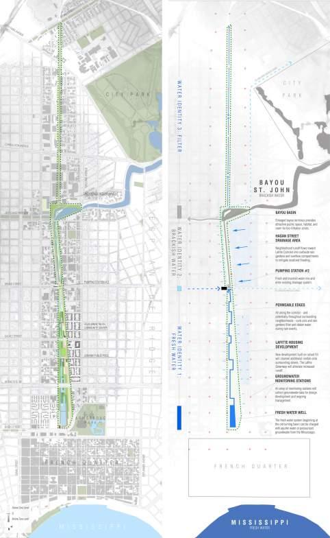
1 Lafitte Greenway Sustainable Water Design New Orleans, Louisiana Initiated by the Friends of the Lafitte Corridor and made possible by a Greater New Orleans Foundation Environmental Fund grant, Waggonner & Ball developed strategies for sustainable water design within the Lafitte Greenway redevelopment. The study was divided into three sections: historical research, data collection and analysis, and the development of illustrative water design potentials for the Lafitte Greenway. The Lafitte Greenway is a linear open space that connects historic neighborhoods in the heart of New Orleans. The proposed 3.1 mile long, bicycle and pedestrian parkway begins at Armstrong Park at the French Quarter, runs through the Tremé, Faubourg St. John, Mid-City and Lower Mid-City neighborhoods and ends at Canal Boulevard. The Bayou St. John, which intersects the corridor at Jefferson Davis Parkway, is the historical entry to New Orleans from Lake Pontchartrain and was connected to the French Quarter via the Carondelet Canal. Now filled and ignored, the former navigation canal and an abandoned railway remain as a public right-of-way. The Lafitte Greenway traces the pathway of a historic maritime and rail transportation corridor. With its connection to one of the city s few open waterways and its prominent role in the city s drainage system, this greenway corridor can provide the community unique urban amenities with ecological, economic, and social value and benefits. New Orleans existing drainage network is overburdened. Frequent street flooding occurs during severe rain events in significant part because the closed, subsurface drainage network has little capacity for water storage. Increasing pumping capacity or conduit size has been, and remains, the typical approach to improve the current system. As a consequence of constant pumping, groundwater is removed from the porous, organic soils. Subsidence results through oxidation processes, with significant consequences to subsurface and surface infrastructure. Additionally, storm water runoff is not mitigated and pollution is flushed directly into Lake Pontchartrain. As a result, traditional infrastructural approaches to address these problems require constant maintenance and therefore have become economically and ecologically unsustainable. Facing similar pressures, the Dutch have developed fundamentally different approaches to water management. They recognize that it is more cost effective and feasible to employ diverse, small scale strategies rather than relying solely on large scale infrastructure projects for water management. Their strategies demonstrate that water sensitive urban design begins with an understanding of subsurface soil and water conditions, followed by adjustments to infrastructure, land uses and spatial planning. Available water - surface water, groundwater, storm water, drinking water and wastewater - is used intensively as a resource. Consequently, urban vulnerability to flooding, drought, extreme heat and land subsidence is reduced through intelligent, water-wise design, efficient operation and effective management. Influenced by this Dutch approach to water sensitive design, Waggonner & Ball Architects developed recommendations for surface water, storm water and groundwater interventions for the Lafitte Greenway that utilize the following sustainable water design principles: alleviate load on pumping system, reduce street flooding, and increase safety by providing space for water storage and retention; minimize subsidence with balanced groundwater; improve water quality by mitigating runoff; promote resilience to climate change, including flood, drought and heat; reconnect neighborhoods and individuals to healthy water network, providing urban amenities and value. 1/9
2 Based upon these principles and addressing unique conditions along the length of the Lafitte Greenway, we developed three distinct areas of hydrological identity: fresh water, brackish water, and a filtration zone. Community engagement and participation during the future master planning efforts will determine the extent and formal arrangement of these water identities within the Lafitte Greenway. Projects like the Lafitte Greenway that managing storm water, balance groundwater, and reintroduce and celebrate surface water will result in a more valuable, vibrant, and ecologically resilient city. Awards 2011, Honor Award, AIA New Orleans 2011, Merit Award, AIA Louisiana Related Publications Don t Fight Nature, Architect Magazine, the official publication of the AIA, 2011 What's Next: Don't Fight Nature Lafitte Greenway Sustainable Water Design, Waggonner & Ball Architects, 2010 Lafitte Greenway Sustainable Water Design Click to Hide Project Info 2/9
3 3/9

4 8/14/12 Waggonner & Ball Architects Lafitte Greenway Sustainable Water Design 4/9

5 8/14/12 Waggonner & Ball Architects Lafitte Greenway Sustainable Water Design Existing & proposed section through the Lafitte Greenway 5/9

6 8/14/12 Waggonner & Ball Architects Lafitte Greenway Sustainable Water Design Water identities change over the course of the Greenway based on surrounding conditions Chapultapec Park in Mexico City 6/9

7 Westerpark in Amsterdam 7/9

8 Westersingel in Rotterdam 8/9
 524-5308 info@wbarchitects.")
9 Future Bayou could circulate water to the French Quarter 2200 Prytania Street, New Orleans, Louisiana (504) All content 2010 Waggonner & Ball Architects 2200 Prytania Street, New Orleans, Louisiana (504) All content 2010 Waggonner & Ball Architects 9/9
NEW ORLEANS LAKEVIEW FLOATING STREETS
 INTERCEPTOR STREETS INTERCEPTOR STREETS: EXISTING UPTOWN TO BUCKTOWN COORDINATING INVESTMENTS LAKEVIEW FLOATING STREETS Katrina Memorial Lake Avenue mixed-use waterfront Networks of bike and pedestrian
LOUISIANA STATE UNIVERSITY COMPREHENSIVE & STRATEGIC CAMPUS MASTER PLAN. APPENDIX G - Stormwater Study Findings & Stormwater Solutions
 LOUISIANA STATE UNIVERSITY COMPREHENSIVE & STRATEGIC CAMPUS MASTER PLAN APPENDIX G - Stormwater Study Findings & Stormwater Solutions LSU: MP Narrative July 2017 3.5 Open Space Existing Conditions The
LIVING WITH WATER. Waggonner & Ball. David Waggonner OREGON ASSOCIATION OF CLEAN WATER AGENCIES JULY 27, 2016 LOUISIANA COASTAL CONDITION
 David Waggonner Waggonner & Ball LOUISIANA COASTAL CONDITION LIVING WITH WATER OREGON ASSOCIATION OF CLEAN WATER AGENCIES JULY 27, 2016 LOUISIANA HIGH + LOW LANDSCAPE LOUISIANA WETLAND LOSS image: Monique
Stormwater Management at The University of New Orleans
 University of New Orleans ScholarWorks@UNO DRU Workshop 2013 Presentations Disaster Resistant University Workshop: Linking Mitigation and Resilience Conferences and Workshops 3-1-2013 Stormwater Management
Claiborne Corridor Cultural Innovation District Green Infrastructure Plan
 Claiborne Corridor Cultural Innovation District Green Infrastructure Plan Background The Claiborne Corridor Cultural Innovation District (CID) is an ongoing strategy with at least those two tenets, culture
MP Program Summary: A resiliency study for Bridgeport, Connecticut and the Long Island Sound.
 Program Summary: A resiliency study for Bridgeport, Connecticut and the Long Island Sound. Program Statement: Thinking in time, working with space, we conceive combinations of natural and fortified solutions
Water Wise NOLA. Representatives of Water Wise NOLA:
 Water Wise NOLA Water Wise NOLA works in collaboration to advance Green Infrastructure by promoting awareness and opportunities through educational, experiential, community-driven design and DIY-based
a path forward P.O. Box New Orleans, LA LafitteGreenway GeorgeLong.com
 a path forward GeorgeLong.com LafitteGreenway.org 504.462.0645 P.O. Box 791727 New Orleans, LA 70179 LafitteGreenway LafitteGreenway the lafitte greenway The Lafitte Greenway is a 2.6-mile public bicycle
Billing Code: DEPARTMENT OF HOUSING AND URBAN DEVELOPMENT [Docket No. FR-6072-N-01]
![Billing Code: DEPARTMENT OF HOUSING AND URBAN DEVELOPMENT [Docket No. FR-6072-N-01]](/thumbs/91/107309814.jpg "Billing Code: DEPARTMENT OF HOUSING AND URBAN DEVELOPMENT [Docket No. FR-6072-N-01]") This document is scheduled to be published in the Federal Register on 12/18/2017 and available online at https://federalregister.gov/d/2017-27194, and on FDsys.gov Billing Code: 4210-67 DEPARTMENT OF HOUSING
This document is scheduled to be published in the Federal Register on 12/18/2017 and available online at https://federalregister.gov/d/2017-27194, and on FDsys.gov Billing Code: 4210-67 DEPARTMENT OF HOUSING
DRAFT FOR PUBLIC REVIEW. Game Plan for a Healthy City
 DRAFT FOR PUBLIC REVIEW 2018 Game Plan for a Healthy City 2 Denveright. Parks & Recreation Game Plan Draft for Public Review Draft for Public Review Executive Summary Game Plan Overview Executive Summary
Toronto Complete Streets Guidelines
 Toronto Complete Streets Guidelines 108 110 7.1 Green Infrastructure Design Principles 112 7.2 Context-Sensitive Green Streets 114 7.3 Key Green Street Elements Green infrastructure refers to natural and
The Mobile Peninsula Corridor Master Plan Dauphin Island Parkway I 10 to Dog River
 The Mobile Peninsula Corridor Master Plan Dauphin Island Parkway I 10 to Dog River Welcome and Introductions Alice Keel Co Founder Prayer Rev. Jim Langston Fulton Road Baptist Church Comments Stewart Hanley,
10.0 Open Space and Public Realm
 10.0 Open Space and Public Realm 10.0 Open Space and Public Realm The Public Open Space System is comprised of: outdoor spaces available for public use that are either publicly owned (e.g., parks and
include playgrounds, sports fields, community gardens and picnic areas.
 DEVELOPMENT PLAN OPEN SPACE SYSTEM OPEN SPACE SYSTEM The neighborhood provides for a range of open space types. The Village Square is an important open space in the neighborhood. It serves as a gathering
Animating the Rideau Canal December 2013
 Executive Summary Animating the Rideau Canal December 2013 Why study the Rideau Canal? The Rideau Canal has been an important part of Ottawa throughout its history, and has shaped and been shaped by the
Green Infrastructure and Low-Impact Development Technologies
 Green Infrastructure and Low-Impact Development Technologies The guiding principles of these technologies is to manage stormwater at their sources using natural means, and establish conditions so that
EXISTING COMPREHENSIVE PLAN
 EXISTING COMPREHENSIVE PLAN Town Center Land Use Element: V. LAND USE POLICIES Town Center Mercer Island's business district vision as described in "Your Mercer Island Citizen-Designed Downtown" was an
S.R.7/U.S.441 COLLABORATIVE THE COLLEGE OF CORRIDOR KNOWLEDGE
 S.R.7/U.S.441 COLLABORATIVE THE COLLEGE OF CORRIDOR KNOWLEDGE S.R.7 Corridor : A Sense of Place? ANYWHERE USA SR 7: Civilizing the Corridor Bad rules = Bad development! The SR 7 Collaborative A model for
FUNDAMENTAL BUILDING BLOCKS
 FUNDAMENTAL BUILDING BLOCKS THE WEB OF GIBSONS - EXISTING Lacks Community Structure and Support Circulation, surface water flow and buildings are disjointed from the community Social neighbourhoods are
CHAPTER 8. Mrs. Zimman s Class - Central Elementary
 SUSTAINABILITY CHAPTER 8 Mrs. Zimman s Class - Central Elementary 8.1 OVERVIEW Green infrastructure also known as low impact development (LID) and environmental or sustainable site design is an environmentally
APPENDIX K WINDSOR OFFICIAL PLAN
 CEAA ENVIRONMENTAL ENVIRONMENTAL IMPACT ASSESSMENT AMBASSADOR BRIDGE ENHANCEMENT PROJECT Replacement Span and Plaza Expansion APPENDIX K WINDSOR OFFICIAL PLAN Avalon Consulting Professionals of Ontario,
Green Gables. April 24, 2013
 Green Gables Preliminary and Final Plat April 24, 2013 Development Team Green Gables Development Corporation (Owner/Developer) DTJ Design (Planner/Landscape Architect) Enertia Consulting Group (Civil Engineer)
An Integrated Approach for Water Management Examples from The Netherlands. Addressing Climate Change and Sea Level Rise
 An Integrated Approach for Water Management Examples from The Netherlands Addressing Climate Change and Sea Level Rise Superstorm Sandy Forum College of Staten Island March 8 2013 Water: a challenge and
Corridor Vision. 1Pursue Minnehaha-Hiawatha Community Works Project. Mission of Hennepin County Community Works Program
 1Pursue Minnehaha-Hiawatha Community Works Project Minnehaha-Hiawatha Community Works is a project within the Hennepin Community Works (HCW) program. The mission of the HCW program is to enhance how the
EXISTING PLANS Harriet Festing Center for Neighborhood Technology Midlothian Community Meeting March 12, 2015
 EXISTING PLANS Harriet Festing Center for Neighborhood Technology Midlothian Community Meeting March 12, 2015 BENEFITS Bring economic, community + environmental benefits Enhance property values Use
SAN RAFAEL GENERAL PLAN 2040 INTRODUCTION AND OVERVIEW
 SAN RAFAEL GENERAL PLAN 2040 INTRODUCTION AND OVERVIEW Steering Committee Presentation February 14, 2018 Purpose of General Plan Guide land use and development decisions Coordinate transportation, infrastructure,
Midtown Greenway Land Use and Development Plan Executive Summary
 Midtown Greenway Land Use and Development Plan Executive Summary Introduction The Midtown Greenway Land Use and Development Plan sets policy direction for land use and development in the Midtown Greenway
Ghent Neighborhood League Briefing Living at Sea Level & Flooding Risks
 Ghent Neighborhood League Briefing Living at Sea Level & Flooding Risks Tuesday, August 11, 2015: Chrysler Museum Presentation by: Tom 757-761-0676 tom@mcneilan.com The Virginia Tidewater For 400+ years,
- Phase. Project. areas using. project from. Project Type: Project is
 Model Community Watershe ed Development - Phase I / Marais des Cannes Location: Lafayette Parish / Scott, LA Client: State of Louisiana / Office of Community Development Disaster Recovery Unit Design Firm(s):
The Five Components of the McLoughlin Area Plan
 The Five Components of the McLoughlin Area Plan This documents contains the complete language of the five components of the McLoughlin Area Plan: The Vision Statement The Values The Guiding Principles
2040 LUP is a part of the Comprehensive Plan and carries the same legal authority. Economic Challenges
 1.1. Guiding Anchorage s Growth Where will new residents settle over the next two decades? Where will people work, shop, and play? Will there be enough room to grow? How will Anchorage look? Will growth
Creating Quality Places: Successful Communities by Design
 Creating Quality Places: Successful Communities by Design Communities across the metropolitan Kansas City area are growing. Our challenge is to shape future development in ways that will maintain and enhance
Chapter 5: Natural Resources and Environment
 NATURAL RESOURCES AND ENVIRONMENT 5-1 5 Chapter 5: Natural Resources and Environment BACKGROUND AND INTENT Urban expansion represents the greatest risk for the future degradation of existing natural areas,
Mainstreaming Green Infrastructure. Township Council Byram Township April 19, 2016
 Mainstreaming Green Infrastructure Township Council Byram Township April 19, 2016 About New Jersey Future. www.njfuture.org Research Policy Advocacy Assistance The Growing Problem Heavier, more frequent
Improve Neighborhood Design and Reduce Non Point Source Water Pollution
 HOW TO Planning Guide Improve Neighborhood Design and Reduce Non Point Source Water Pollution This document was funded by a grant from the New Hampshire Coastal Program with funding from the National Oceanic
PORT UNION VILLAGE COMMUNITY SECONDARY PLAN
 4 PORT UNION VILLAGE COMMUNITY SECONDARY PLAN 4. PORT UNION VILLAGE COMMUNITY SECONDARY PLAN The following policies and principles apply to the area herein referred to as Port Union Village, as outlined
Wasatch CHOICE for 2040
 Wasatch CHOICE for 2040 Economic Opportunities We Can Choose a Better Future We enjoy an unparalleled quality of life along the Wasatch Front. People from all over the world are drawn to our stunning scenery,
Whittier Greenway Trail. Est. 2009
 Whittier Greenway Trail Est. 2009 The Whittier Greenway Trail begins in the northwest corner of Whittier, near the 605 Freeway, and closely parallels Whittier Boulevard. When it reaches Painter Avenue,
Case studies. B1.1 Lloyds Crossing, Portland (USA)
") B. Case Studies 57 B1 Case studies B1.1 Lloyds Crossing, Portland (USA) Lloyds Crossing in Portland is a brownfields redevelopment site in the central city area, with the aim of: Developing a conceptual
B. Case Studies 57 B1 Case studies B1.1 Lloyds Crossing, Portland (USA) Lloyds Crossing in Portland is a brownfields redevelopment site in the central city area, with the aim of: Developing a conceptual
South District What we heard
 What we heard Vision to 2056 and Priorities Governance and implementation Infrastructure and funding Feedback supported: The vision for a metropolis of three cities, but emphasised the importance of infrastructure
C. Westerly Creek Village & The Montview Corridor
 C. Westerly Creek Village & The VISION Community Vision When the goals of the city are achieved Westerly Creek Village, a distinctive community defined by Montview Boulevard and Westerly Creek, is a strong
CITY OF TARPON SPRINGS DCA#11-1AR
 Agenda Item #3.H.2 05/09/11 TAMPA BAY REGIONAL PLANNING COUNCIL LOCAL GOVERNMENT COMPREHENSIVE PLAN ADOPTED AMENDMENT REPORT CITY OF TARPON SPRINGS DCA#11-1AR 1 ADOPTED WITH THE FOLLOWING CHANGES: Ordinance
Learning Objectives. Introduction. Design at an Ecodistrict Scale can Change Washington, DC s Landscape
 Learning Objectives Design at an Ecodistrict Scale can Change Washington, DC s Landscape Presenters Elizabeth Miller, ASLA, National Capital Planning Commission Diane Sullivan, National Capital Planning
Visioning Statement and Guiding Principles
 Visioning Statement and Guiding Principles Planning for the Future The General Plan The General Plan represents Woodland's shared vision of the future and defines a path to lead the community toward its
Multifunctional Green-Blue Cities MAINSTREAMING GREEN-BLUE INFRASTRUCTURE
 Multifunctional Green-Blue Cities MAINSTREAMING GREEN-BLUE INFRASTRUCTURE WORLD WATER WEEK TOM ARMOUR 31.08.2017 SHUTTERSTOCK SHIBUYA, TOKYO by 2050, 70% will live in cities * UNITED NATIONS WORLD URBANISATION
BROOKHILL NEIGHBORHOOD MODEL ZONING MAP AMENDMENT PREFACE TO APPLICATION
 BROOKHILL NEIGHBORHOOD MODEL ZONING MAP AMENDMENT PREFACE TO APPLICATION June 15, 2015 Revised: August 1, 2016 I. VISION Brookhill is a proposed community based upon the principles of Albemarle County
RECREATION AND OPEN SPACE ELEMENT GOALS, OBJECTIVES, AND POLICIES
 RECREATION AND OPEN SPACE ELEMENT GOALS, OBJECTIVES, AND POLICIES Goal 7 To provide park facilities, recreation programs, and open space resources that are safe, adequate, and accessible to all City residents,
Craven Street Stormwater Improvement Projects
 Craven Street Stormwater Improvement Projects The Craven Street Watershed drains the area from Haywood Road to Westwood Place and down Haywood to the French Broad River. The watershed has one main un-named
Tyvola & Archdale Transit Station Area Plan. May 15, 2008
 Tyvola & Archdale Transit Station Area Plan First Public Meeting May 15, 2008 Presentation Outline 1. Purpose and Process 2. Station Area Overview 3. Plan Recommendations Vision Land Use Transportation
Ivywild On The Creek PRELIMINARY CREEK DISTRICT MASTER PLAN
 Ivywild On The Creek PRELIMINARY CREEK DISTRICT MASTER PLAN Introduction: Rejuvenating an extraordinary Creekside neighborhood THE CREEKSIDE DISTRICT The Ivywild On The Creek Neighborhood District Master
Chairman and Members of the Planning and Development Committee. Thomas S. Mokrzycki, Commissioner of Planning and Building
 LA.09.TOR (Toronto) DATE: TO: FROM: SUBJECT: Chairman and Members of the Planning and Development Committee Thomas S. Mokrzycki, Commissioner of Planning and Building Central Waterfront Secondary Plan
3.9 Systems Interrelationships
 191 Sustainability Building Blocks: The Comprehensive Plan Systems Community Form Economy Social Transportation Natural Resources Housing and Neighborhoods Utilities and Infrastructure Institutions.9 Systems
The following principles guide the development of goals and strategies to protect and promote these amenities:
 OPEN SPACE/PARKS/TRAILS/RECREATION GOALS/STRATEGIES Cherry Hills Village is a living environment that offers low density development, open areas, public scenic vistas, public trails and public parks. This
Western City District What we heard
 What we heard Vision to 2056 and Priorities Governance and implementation Infrastructure and funding The protection of the natural landscape including biodiversity and the Metropolitan Rural Area for food
Queensborough Eastern Neighbourhood Node. Community Open House
 Queensborough Eastern Community Open House The Vision The Queensborough Eastern will become the heart of eastern Queensborough. Through a sensitive mix of viable commercial and residential areas, the neighbourhood
TIRZ 17/Redevelopment Authority Capital Improvements Plan Projects
 Gessner Widening: T-1701 What: Widen the road from a six-lane divided boulevard to an eight-lane divided boulevard street section, increase turn lanes, update traffic signal system, improve drainage by
Making TOD Work in the Heart of Suburban Sprawl
 Making TOD Work in the Heart of Suburban Sprawl Rocky Mountain Land Use Institute March 6, 2009 Speakers Ben Herman, FAICP, Principal Clarion Associates Darcie White, AICP, Principal Clarion Associates
North Fair Oaks Community Plan Summary and Information
 North Fair Oaks Community Plan Summary and Information WHAT IS THE NORTH FAIR OAKS COMMUNITY PLAN? The North Fair Oaks Community Plan is part of the San Mateo County General Plan, and establishes policies
Sustainable Stormwater Management through Green Infrastructure. Jersey City Public School #5
 Green Infrastructure Site Evaluation Friday, October 25 th, 2013 Sustainable Stormwater Management through Green Infrastructure Jersey City Public School #5 FORMAT: (15 minutes) An Introduction to Stormwater
CAMBIE CORRIDOR PLAN
 1 WELCOME TO THE OPEN HOUSE PUBLIC REALM PLAN - CAMBIE CORRIDOR Thank you for coming to the Cambie Corridor Public Realm Open House! Place a dot where you live Please provide us with your comments and
City of Hermosa Beach Administrative Policy #
 City of Hermosa Beach Administrative Policy # SUBJECT: Living Streets Policy Date: Approved by: City Council Authority: Public Works Department & Community Development Department Mayor, PURPOSE The City
Plano Tomorrow Vision and Policies
 Plano Tomorrow Vision and Policies PLANO TOMORROW PILLARS The Built Environment The Social Environment The Natural Environment The Economic Environment Land Use and Urban Design Transportation Housing
Potential Green Infrastructure Strategies May 6, 2015 Workshop
 Potential Green Infrastructure Strategies May 6, 2015 Workshop Background The City of Cortland is developing the Tioughnioga Urban Headwaters Green Infrastructure Action Plan with funding from the National
T O W N O F H I G H R I V E R
 T O W N O F H I G H R I V E R o p e n s p a c e p l a n The Town of High River, 30 minutes South of Calgary, still retains much of its distinctive small town character and provides residents with a high
CHAPTER 7: Transportation, Mobility and Circulation
 AGLE AREA COMMUNITY Plan CHAPTER 7 CHAPTER 7: Transportation, Mobility and Circulation Transportation, Mobility and Circulation The purpose of the Transportation, Mobility and Circulation Chapter is to
Smart Growth Development Checklist
 2004 Smart Growth Development Checklist Smart Growth Development Checklist Corporation of the City of New Westminster Guide and manage growth in a manner which is consistent with the principles of sustainable
Preliminary Recommendations Tk Takoma/Langley Crossroads Sector Plan
 Preliminary Recommendations Tk Takoma/Langley Crossroads Sector Plan Vision is to achieve a Transit Oriented, pedestrian friendly Community that Celebrates and builds upon the cultural Diversity of the
Green Infrastructure & Low Impact Development
 Green Infrastructure & Low Impact Development CITY OF COVINGTON STORMWATER MANAGEMENT WHAT IS GREEN INFRASTRUCTURE? Green infrastructure uses vegetation, soils and natural processes to manage water and
In the Mississippi Delta: Building with Water
 Page 1 of 5 POSTED 09.09.10 Elizabeth Mossop and Jeffrey Carney In the Mississippi Delta: Building with Water 20th century wetland loss, mapping by LSU professors Michael Blum and Harry Roberts. [by the
Post - Construction Hydromodification Development Requirements
 Condensed Version - Interim Low Impact Development / Hydromodification Guidelines, City of Lompoc 1 Post - Construction Hydromodification Development Requirements I. PURPOSE A. The purpose of these requirements
Public Open House. Overview of the Downtown Plan Official Plan Amendment April 23, 2018
 Public Open House Overview of the Downtown Plan Official Plan Amendment April 23, 2018 1 A 25-Year Plan for Downtown To ensure growth contributes positively to Toronto s Downtown as a great place to live,
Chapter 4 - Master Plan
 MAUKA / EAST NORTH SOUTH CAMPUS Illustrative Plan MAKAI / WEST 39 Open Space Network & Parks Open space trails Armory Park in Lahaina Waipuilani Gulch Open space is essential to a healthy community. Successfully
CONTENTS 6.1 URBAN DESIGN
 6-2 Urban Design and Sustainable Development 6.0 URBAN DESIGN AND SUSTAINABLE DEVELOPMENT CONTENTS 6.1 URBAN DESIGN 6.1.1 General Policies 6.1.2 The Public Realm 6.1.3 Streets and Blocks 6.1.4 Streetscapes
New Orleans East District 9, 10 & 11. St. Martin Brown & Associates
 New Orleans East District 9, 10 & 11 Work with neighborhoods to develop revitalization plans that are rational, thoughtful, can be implemented, and formed into a citywide recovery plan for submission
STORMWATER QUALITY MARION STREET GREEN INFRASTRUCTURE PROJECT COMMON SOURCES OF URBAN POLLUTANTS URBAN STORMWATER
 STORMWATER QUALITY COMMON SOURCES OF URBAN POLLUTANTS Fertilizers Litter Pet-waste COMMON POLLUTANTS FOUND IN URBAN STORMWATER BACTERIA TRASH METALS Dumpsters Vehicle exhaust, automotive fluids, etc. IMPACTS
DEALING WITH STORM WATER MANAGEMENT
 December 2012 DEALING WITH STORM WATER MANAGEMENT This fact sheet provides information on the guiding principles of storm water management practices, explains the difference between structural and non-structural
Central City District What we heard
 What we heard Vision to 2056 and Priorities Governance and implementation Infrastructure and funding The vision for a metropolis of three cities, and the 30 minute city. Feedback requested: Clearer communication
Appendix E: Illustrative Green Infrastructure Examples
 Appendix E: Illustrative Green Infrastructure Examples Integrating LID into San Francisco s Urban Landscape Figure E. High-density Residential Figure E. Low-density Residential Figure E. Mixed Use 7 Figure
An Ambitious Plan: Transforming the blighted South Platte River and surrounding environment into Denver s greatest natural resource.
 CONNECTING THE PEOPLE TO THEIR RIVER SOUTH PLATTE RIVER VISION IMPLEMENTATION PROGRAM: GRANT-FRONTIER PARK TO OVERLAND POND PARK REACH The South Platte River Vision Implementation Program (River Vision)
Witteveen+Bos. Strategy // Planning // Design for resilient urban places. Rachael Cox April 2017
 Healthy Witteveen+Bos: & Resilient Cities: Designing Urban Healthy Planning & and Resilient Engineering Cities 1 Witteveen+Bos Strategy // Planning // Design for resilient urban places Rachael Cox April
Community Design Guidelines. Port Wallace DRAFT
 Community Design Guidelines Port Wallace DRAFT Energy 1 2 3 Nature Movement Connections Built Form DRAFT Layout Energy 1 Nature Community Design Guidelines GREAT COMMUNITIES PROTECT, CELEBRATE, AND CONSERVE
PRINCIPLE 6: Preserve open space, farmland, natural beauty, and critical environmental areas
 HOW TO APPLY SMART GROWTH PRINCIPLES TO RURAL COMMUNITIES PRINCIPLE 6: Preserve open space, farmland, natural beauty, and critical environmental areas A product of AND A cooperative publication from the
Ecosystem Services beyond Flood Mitigation
 Sustainable Urban Drainage Systems Ecosystem Services beyond Flood Mitigation Professor Tony Wong Chief Executive & Director Centre for Water Sensitive Cities Monash University Effective Drainage & Flood
NEIGHBORHOOD DESIGN ELEMENT
 NEIGHBORHOOD DESIGN ELEMENT INTRODUCTION The following recommendations constitute an urban design oriented "neighborhood analysis" of Plantation. It is an optional Comprehensive Plan Element. The five
Clovis Urban Greening Plan. Community Workshop #2 Northwest
 Clovis Urban Greening Plan Community Workshop #2 Northwest Thursday, October 9, 2014 WHAT IS AN URBAN GREENING PLAN? A guide to help the City to improve quality of life for residents Identification of
COLLIER BOULEVARD (CR 951) CORRIDOR
 CORRIDOR") Project(s) Goals Improve Traffic Circulation, Capacity & Safety Focus on Safety During Design & Construction Address Public Concerns Design an Aesthetically Pleasing Project Limit Environmental Impacts
Project(s) Goals Improve Traffic Circulation, Capacity & Safety Focus on Safety During Design & Construction Address Public Concerns Design an Aesthetically Pleasing Project Limit Environmental Impacts
Pinellas County Greenways
 Pinellas County Greenways USING GREENWAYS TO LINK OPEN SPACES The Florida Greenways Commission has defined a greenway as...a corridor of protected open space that is managed for conservation and/or recreation.
The Flow. Green Infrastructure Taking Root in Cities 3/23/2015. Green Infrastructure Evolution City Plans/Projects Measureable and Holistic Benefits
 Green Infrastructure Taking Root in Cities Robert Hopper, P.E. CDM Smith The Flow Green Infrastructure Evolution City Plans/Projects Measureable and Holistic Benefits 2 1 Parts, Systems, Whole The first
The transportation system in a community is an
 7 TRANSPORTATION The transportation system in a community is an important factor contributing to the quality of life of the residents. Without a sound transportation system to bring both goods and patrons
PORT WHITBY COMMUNITY
 PORT WHITBY COMMUNITY SECONDARY PLAN UPDATE COMMUNITY IMPROVEMENT PLAN URBAN DESIGN GUIDELINES September 2015 DRAFT PROPOSED AMENDMENT NUMBER # to the Whitby Official Plan PURPOSE: The intent of this Amendment
Public Meeting #3 May 9, 2009 MVVA Team
 Public Meeting #3 May 9, 2009 MVVA Team Welcome to the third Public Meeting for the Lower Don Lands Municipal Class Environmental Assessment (EA) Infrastructure Master Plan and Keating Channel Precinct
Purpose of Open House #3
 Public Meeting #3 May 9, 2009 MVVA Team Purpose of Open House #3 The main purpose of this Open House is to present and seek input on the: Evaluation of transportation and infrastructure design alternatives
The West Vaughan Employment Area Secondary Plan Policies
 Part 2: The West Vaughan Employment Area Secondary Plan Policies 2.1 General Policies It is the policy of Council: 2.1.1. That the West Vaughan Employment Area (the WVEA), identified on Schedule 1, will
Catherine Bray John Buss Manager City of Tallahassee/Stormwater Management
 Florida Stormwater Association EXCELLENCE AWARD for STORMWATER PROGRAMS and PROJECTS NOMINATION FORM I. Nomination Information Nomination Category (please check only one box): Program (Department/Division)
TOWN BRANCH COMMONS & VINE STREET MOBILITY IMPROVEMENTS
 TOWN BRANCH COMMONS & VINE STREET MOBILITY IMPROVEMENTS CONTACT: Jeff Fugate, President O: 859-367-4972 F: 859-425-2292 JFugate@LexingtonDDA.com www.lexingtondda.com TOWN BRANCH COMMONS & VINE STREET MOBILITY
4 Sustainability and Growth Management
 4 Sustainability and Growth Management Introduction Traditionally, has assumed growth and development with limited consideration for the long-term negative social, environmental or economic impacts on
GREEN STREETS & INFRASTRUCTURE: A COUNTY APPROACH. Mimicking Nature to Manage Stormwater in Developed Areas
 GREEN STREETS & INFRASTRUCTURE: A COUNTY APPROACH Mimicking Nature to Manage Stormwater in Developed Areas Jennifer Gonzalez, Environmental Planner Passaic County Depar tment of Planning & Economic Development
USF System Campus Master Plan Updates Goals, Objectives and Policies
 2015-2025 USF System Campus Master Plan Updates Goals, Objectives and Policies Tampa Goals, Objectives, and Policies Table of Contents Executive Summary 2015 2025 USF Campus Master Plan Update Introduction
Sustainable Stormwater Management with Low Impact Development (LID)
") Sustainable Stormwater Management with Low Impact Development (LID) Chui Ting Fong, May Department of Civil Engineering The University of Hong Kong HKIE Seminar Nov 27, 2014 1 Hydrologic Impact of Urbanization
Sustainable Stormwater Management with Low Impact Development (LID) Chui Ting Fong, May Department of Civil Engineering The University of Hong Kong HKIE Seminar Nov 27, 2014 1 Hydrologic Impact of Urbanization
EAST VILLAGE STRATEGIC SITE NOVEMBER 2017
 EAST VILLAGE STRATEGIC SITE NOVEMBER 2017 East Village will be a sustainable, mixeduse precinct with a focus on innovative employment and education opportunities. Enhanced by green spaces and places for