ROSSLYN GATEWAY URBAN DESIGN MANUAL JULY 15, 2011 REVISED JANUARY 30, KOHN PEDERSEN FOX ASSOCIATES PC. All rights reserved.
|
|
|
- Moris Wright
- 6 years ago
- Views:
Transcription
1 ROSSLYN GATEWAY URBAN DESIGN MANUAL JULY 15, 2011 REVISED JANUARY 30, 2012
2 OVERVIEW Rosslyn Gateway is mixed-use development located at the Virginia landing of the Francis Scott Key Bridge in Rosslyn, VA. The development will serve as a gateway to Virginia and the Rosslyn-Ballston corridor, considered one of the country s preeminent transit-oriented urban environments in which residential, retail, office and cultural uses all seamlessly integrate into the built environment. The Rosslyn Gateway phased development plan proposes three new towers - office, hotel/residential and residential which are bound to the north by Lee Highway East, to the south by 19th Street, to the west by Ft. Myer Drive, and to the east by North Moore Street. Project phasing currently includes two phases: an initial phase which will include the new office building replacing the existing building on the south end of the site and a hotel/residential tower replacing parking at the northeast corner of the site. During this phase, the existing office building located in the northwest corner of the site will remain in place. The final phase will consist of this building being replaced by the new residential tower on the site, completing the integrated, three building site plan. Rosslyn Gateway, through its architecture and landscape design, will extend the reach of the active central business district in downtown Rosslyn, by featuring pedestrian-friendly streetscapes, vibrant ground floor retail amenities, and convenient access to nearby parks and bicycle paths. Attention to details such as planting, seating and lighting will also contribute to the quality of the pedestrian experience. The redevelopment of an urban location and multi-modal access to the development minimizes the impact that the new buildings will have on the environment. As such, sustainability is a critical component of the design, with elements and features incorporated into the buildings to improve the development s environmental footprint. The Rosslyn Gateway development will create a worldclass destination to work, live, and play in Arlington, Virginia 2
3 TABLE OF CONTENTS PREFACE 2 OVERVIEW 2 TABLE OF CONTENTS 3 CREATING A GOOD URBAN PLACE 4 SITE ANALYSIS 5 CONTEXT 6 TRANSPORTATION 8 CIRCULATION / ENTRY 9 PLANNING CONTEXT 10 LAND USE 11 URBAN DESIGN PRINCIPLES 12 DESIGN PRINCIPLES 13 BUILDING HEIGHTS 15 PHASED DEVELOPMENT 16 PDSP 17 PHASING 18 BUILDING GUIDELINES 19 MASSING 20 ARCHITECTURAL ELEMENTS / MATERIALS 21 GROUND FLOOR RETAIL 22 SIGNAGE 23 LANDSCAPE GUIDELINES 24 STREETSCAPE 25 TREE PLANTING SECTIONS 26 CROSSWALK PLAN 27 GREENWALL 28 PLANTS - SUN 29 PLANTS - SHADE 30 STREET SECTIONS 31 PROPOSED STREET SECTIONS 32 3
4 CREATING A GOOD URBAN PLACE Active Streetscape: Establish pedestrian friendly streetscapes that encourage active use of ground level and sidewalk program. Maintain retail and signage standards of Arlington County. Integrate paving, seating and lighting to enhance pedestrian experience. Ensure that ground level program is designed for public access along the sidewalks and from building lobbies to provide retail amenities to the surrounding community. Appropriate sizing of public spaces (streets + sidewalks) for their use and purpose. Architecture: Design a building whose massing is consistent with surrounding context and creates a visually appealing symbolic gateway to Arlington County. Provide consideration of the human scale at street level, transitioning scales and incorporating materials appropriate for their public function. Green Elements: Street planting and other vegetation contribute to softening the sidewalk and create a buffer between pedestrian and vehicle. Integrate greenery into the building itself with landscaped roof terraces and green walls as appropriate. 4
5 SITE ANALYSIS 5

6 CONTEXT 6 KPF.THE]BGC... OMPANIEs


7 CONTEXT Rosslyn Gateway is comprised of a site in northeast Rosslyn, VA overlooking the Potomac. Located in the DC metro area, this site has direct views to the National Mall to the east and Georgetown to the north. The site s location at the Virginia landing of the Francis Scott Key Bridge allows the project to effectively serve as a gateway to Arlington County. Surrounding Land Use The land surrounding the site consists primarily of office buildings with a few hotels and residential towers. Transportation Located a block away from the Rosslyn Metro stop, the site offers convenient access from both public transportation and the adjacent highways. Arlington Gateway Park The Arlington Gateway park serves as an amenity for the Rosslyn BID and when revitalized, for the larger community. Current Use of the Site Two office buildings and a parking structure (circa ) are currently located on the site. The applicant proposes to eventually add three new towers (office, hotel/residential and residential) to the site under a Phased Development Site Plan. The initial phases would tear down one office building and the parking structure and construct a new office building and a hotel/ residential tower. An additional residential building would be constructed at a later phase. GATEWAY TO VIRGINIA ROSSLYN GATEWAY VIEW FROM GEORGETOWN View from Georgetown 7


8 EXISTING TRANSPORTATION Highway Metrobus Primary Street MetroRail Orange Line Metrobus Express Secondary Street Bike Route MetroRail Blue Line ART Street Hierarchy Bike Lanes MetroRail Metrobus and ART 8

9 CIRCULATION CIRCULATION & ENTRANCES Vehicular The private service drive eliminates the need for loading and garage entrances of of the public streets. All parking and loading access to the buildings will be through a private service drive, running eastwest through the center of the site. The hotel and residence drop off is on Lee Highway. Pedestrian The site is a short walk from the Rosslyn Metro stop to the south. Pedestrians may enter through the various lobby entrances listed below. Bicycle Bicycle storage will be provided in B1 level of the garage. Bike lanes are located along North Lynn Street, Fort Myer Drive and Lee Highway. Bicycle access to the buildings will be through the service drive running east-west through the center of the site. ENTRANCES Hotel/Residential The hotel/residential lobby and drop off is located on the north edge of the site off of Lee Highway. Office The office lobby and entrance are on the south edge of the site. Residential The residential lobby is adjacent to the hotel/residential lobby and drop off to the north of the site. Service Service vehicles may enter through the service drive in the center of the site and loading and handling will be managed within the parking garages and truck dock to avoid blocking the street. Parking Parking for the building is provided through two separate garages.. The below grade levels are managed parking for the office, hotel, and future residential uses uses, while the above-ground parking uses an automated valet parking system for the residential usage above the hotel. 9
10 PLANNING CONTEXT In late 1977, as part of Arlington County s Metro Station Area Planning process, the County released the Rosslyn Transit Station Area Study, which provided planning guidance for the area generally bounded by Lee Highway, Interstate 66/Highway 110, Arlington Boulevard and North Rhodes Street. The Study partially updated the 1962 Rosslyn Plan and was intended to ensure coordination of public and private improvements within the Metro station areas in accordance with the recently-adopted General Land Use Plan. In 1992, the County released the Rosslyn Station Area Plan Addendum, which updated the Rosslyn Transit Station Area Study and provided area-wide planning objectives, as well as sitespecific goals for the project site. The Addendum included, among others, the following area-wide objectives for Rosslyn: Restructure and enhance retail, restaurant, and entertainment facilities. Integrate the sidewalks and skywalks into a comprehensive pedestrian circulation system, which links all the major components of Rosslyn (residential, office, and retail) into a unified whole. Create a more urban form where buildings relate well to one another, and to the street, and exemplify good architectural and urban design practice. Enhance entries both from within and without Arlington. Increase opportunities for housing within the core of Rosslyn. Expand and enhance Rosslyn s hotel resources. Develop an office inventory, which is both more cosmopolitan and more competitive in the marketplace. The Addendum also suggested the following specific potentials for the project site: The possibility of providing an effective counterbalance to the focal building in the central place, thereby creating a much more complete urban design composition. A much improved skyline and, therefore, image for Rosslyn. This is especially true if sites A [site of the Waterview] and D [site of the Holiday Inn and Turnberry Tower] also redevelop. By the same token, the northern gateway for Rosslyn and the County could become one of the most spectacular in the region. The current General Land Use Plan designates the project site as High Office- Apartment-Hotel and within the Rosslyn Coordinated Redevelopment District. The project site is currently zoned C-O, which allows only limited office building land use, and under appropriate conditions rebuilding with high-rise office buildings, hotels, or multiple-family dwellings. The Applicant has requested a rezoning to C-O Rosslyn, which zoning classification was adopted in 1996 because the County recognized that, although Rosslyn is modern, densely developed, and well located in the area, in the coming years property owners will be faced with the need to rehabilitate buildings or face the loss of tenants and Rosslyn s competitive edge in the region. In order to respond to this anticipated need for development and to implement the bold new vision for Rosslyn established in the Addendum, the County adopted the C-O Rosslyn classification, which provides incentives for building owners to rehabilitate or redevelop sites to achieve many of the same goals identified in the Addendum. Specifically, C-O Rosslyn encourages developers to: Create premier office space suitable for regional and national headquarters of major corporations and international firms. Provide hotels that expand and enhance hotel services for Rosslyn and Arlington County businesses, residents, and visitors. Provide residential development that meets the housing goals and policies of Arlington County. Implement urban design, streetscape, and open space plans and policies. Achieve the policy objectives for increasing retail commercial services in the center of Rosslyn. Facilitate the implementation of public features and amenities, including the Central Place, and the Esplanade. The Applicant s proposal meets the goals of the Rosslyn Station Area Plan Addendum and the C-O Rosslyn zoning classification by providing mixed-use development, including a high quality hotel, residential units, an office tower, and street level retail in the heart of Rosslyn. The mini-loop road, the system of reverse flow lanes around these two blocks, could be eliminated. The space thus gained could be used partially for additional sidewalk width and to provide additional buildable area. The end result would be a more attractive streetscape with reduced emphasis on the automobile and better spatialrelationships block to block. The creation of additional housing in the core of Rosslyn. 10

11 LAND USE NORTH MOORE Office Hotel Hotel / Residential Residential Retail Frontage 11
12 URBAN DESIGN PRINCIPLES 12


13 DESIGN PRINCIPLES Keys to a Good Urban Plan Create walkable pedestrian friendly streets and sidewalks with a logical hierarchy. Create pedestrian connections that include planting, seating and lighting, and other landscape elements. Provide for street level program such as retail or restaurant that activates the street and sidewalk and invites the pedestrian to interact with the building. Allow the architecture and landscape design to help reinforce a sense of community within Rosslyn and create a variety of interesting spaces. Provide a clear hierarchy of massing within the building elements and as the building meets the street. 505 Fifth Avenue - Active retail storefront Make sure that adjacencies are considered so that complementary uses are located in close proximity. Keep service areas away from public areas and within buildings if possible. Build sidewalks that are the appropriate width for their use and purpose. Canal Housing - Pedestrian streetscape with outdoor dining and retail 13


14 DESIGN PRINCIPLES Mission Street - Outdoor seating and lighting When creating an effective urban plan for Rosslyn Gateway, focusing on creation of an active streetscape, attention must be paid to primary urban planning considerations. Retail storefronts can activate the street as seen in both 505 Fifth Avenue and The Landmark. Additionally, allowance for outdoor dining or other seating elements allow the sidewalk to function as a continuation of indoor programed space as shown in the Canal Housing. Attention to details such as planting, seating and lighting contribute to the quality of the outdoor environment. Mission street combines lighting with seating to create a unique pedestrian friendly environment. The Landmark - Active retail storefront and lobby 14

15 BUILDING HEIGHTS AVERAGE SITE ELEVATION OFFICE BUILDING = HOTEL/RESID. BUILDING = RESIDENTIAL BUILDING = The proposed heights and massing of the buildings relates to their context. The three towers step down in height as they approach the water and are appropriately scaled to fit in with the existing urban fabric. 15
16 PHASED DEVELOPMENT 16

17 PHASED DEVELOPMENT SITE PLAN RESIDENTIAL BUILDING TBD Ground Floor Interim Phase with Existing Rosslyn North Tower Ground Floor Final Buildout 17

18 PHASING Project Phasing Project phasing currently includes two phases: an interim phase in which the existing northwestern building will remain standing while a new office tower and hotel/residential tower are built around it, and the final buildout phase in which the new residential tower will be completed. During the interim phase, a portion of the existing loop road will remain but will be converted to a different use. The drop off area and loop road are revised in the final buildout to allow both entry and exit from Lee Highway. Interim Phase with Existing Rosslyn North Tower Final Buildout 18
19 BUILDING GUIDELINES 19


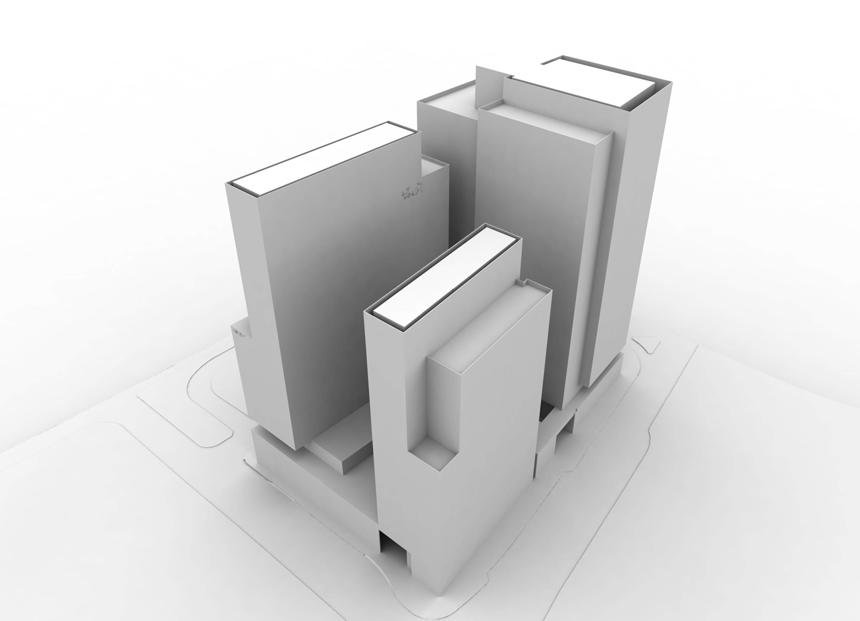
20 MASSING Massing View from the Northeast Massing View from the Northwest Massing View from the Southeast Massing View from the Southwest 20
21 ARCHITECTURAL ELEMENTS / MATERIALS Height and Massing The final buildout of Rosslyn Gateway consists of three towers which decrease in height as they near the water. The height and overall proposed massing are consistent with the surrounding buildings and create a courtyard facing the water which maximizes potential for light and views. Architectural Elements The base of the building is designed to relate to the adjacent sidewalk and human scale. Ground floor retail and food service contribute to the pedestrian experience with storefront glass increasing visibility into these program spaces. The northern face of the building at grade creates a connection with the park and allows for a continuous pedestrian experience along Lee Highway. A green wall extends into the service drive on the south side of the building. The building s exterior wall system is composed of precast concrete, metal panels, and glass. On the podium level stone may be used in place of the precast. Recessed Juliet balconies, along with typicla recessed balconies, are integrated into the curtain wall for the condo units and their glass guardrails are flush with the building facade. All mechanical systems will be located within the building, screened at the roof, or will be designed so that they merge seamlessly with the building facade. All loading doors shall be solid metal or horizontal slat doors and shall be located within the service drive. They shall be painted so that they blend with the surrounding facade. 21


22 GROUND FLOOR RETAIL Ground Floor Retail Characteristics Ground floor retail and food service shall be located along all four sides of the buildings along Fort Myer Drive, North 19th Street, North Moore Street, and Lee Highway. The main entrance to the office building is on the south side of the building. Retail entrances are on the west and south sides of the building. The office entrance is on the south side of the proposed RG office building at the south end of the site. The street facade of the retail portion shall be composed as a single plane that integrates with the curtainwall system with options for differentiation available within the outer glass shell. Windows and doors Window glass shall be clear for retail. Doors shall be made of stainless steel and clear glass. Accent materials are glass rods, and stone. Ground floor commercial space shall be serviced by loading facilities internal to the building. Signage The food service storefront signage will be integrated with the typical stainless steel signage of the building while the retail signs will be painted metal. The retail signs will serve to establish retail identities that allow for successful retail at the base of the towers. The retail will have an independent identity in the buildings. Square footage of all signage has been provided within the limits set out by Arlington County. Signage locations will be provided for the office and residential tower and guidelines will be set up for the individual retail tenants. LANDSCAPE WILL BE UPDATED WHEN LANDSCAPE DESIGN IS FINALIZED 22


23 SIGNAGE Creative lighting will be provided to enhance the internal illumination of the building, naturally provided by the occupants. Lighting on the tops of the buildings will be internally lit to provide distinctive crowns. Signage will be internally lit similar to the signage shown for 505 Fifth Avenue and The Landmark. Signage 505 Fifth Avenue - Retail Signage Signage Signage Signage on North Facade The Landmark - Retail Signage 23
24 LANDSCAPE GUIDELINES Roof Terraces 24


25 STREETSCAPE LANDSCAPE WILL BE UPDATED WHEN LANDSCAPE DESIGN IS FINALIZED NORTH MOORE STREET Streetscape Details Streetscapes will be designed to provide a safe and attractive means of pedestrian circulation, and to encourage linkages between the community and program amenities. Planting areas will be designed to accomodate bushes and ground cover which will enhance the character of the street. Lighting will also be provided with Carlyle fixtures which are typical in the area and attention will be paid to paving patterns and details along the sidewalk. The building must meet the sidewalk where retail facades are located. FORT MYER DRIVE FORT MYER DRIVE 19TH STREET 25

26 TREE PLANTING SECTIONS LANDSCAPE WILL BE UPDATED WHEN LANDSCAPE DESIGN IS FINALIZED Tree Planting Detail for Street Tree in Pit *source Arlington VA Landscape Standards 26
27 CROSSWALK PLAN new crosswalk existing crosswalk 27

28 GREEN WALL Green Wall Proposal on Site A green wall is located on the podium on the south facing eastern wall of the service drive. The green wall provides many benefits to the building including protection of the facade and acoustical properties which allow it to dampen noise pollution in the service drive area. A variety of appropriate plant species will be planted on a backing support material that distributes water and nutrients evenly making the system inherently low mainenance. The green wall adds to the visual as well as environmental appeal of the project and creates a visual indicator of the building s energy efficiency. GREEN WALL 28
29 PLANTS - SHADE KPF THE]BG CoMPANIEs 29

30 PLANTS - SUN 30 KPF THE]BG CoMPANIEs
31 STREET SECTIONS 31


32 STREET SECTIONS FORT MYER DRIVE CROSS SECTION A-A LOOKING NORTH LEE HIGHWAY CROSS SECTION B-B LOOKING EAST 32


33 19TH STREET CROSS SECTION C-C LOOKING EAST NORTH MOORE STREET CROSS SECTION D-D LOOKING EAST PRIVATE SERVICE DRIVE CROSS SECTION E-E LOOKING EAST 33
Policies and Code Intent Sections Related to Town Center
 Policies and Code Intent Sections Related to Town Center The Town Center Vision is scattered throughout the Comprehensive Plan, development code and the 1994 Town Center Plan. What follows are sections
ARLINGTON COUNTY, VIRGINIA
 ARLINGTON COUNTY, VIRGINIA County Board Agenda Item Meeting October 15, 2005 DATE: September 28, 2005 SUBJECT: Request to Advertise the adoption of the 2005 Clarendon Sector Plan C. M. RECOMMENDATION:
ELMVALE ACRES SHOPPING CENTRE MASTER PLAN
 ELMVALE ACRES SHOPPING CENTRE MASTER PLAN Contents 1.0 INTRODUCTION... 2 2.0 LOCATION... 2 3.0 EXISTING CONTEXT... 2 4.0 VISION & GUIDING PRINCIPLES... 2 5.0 LAND USE AND BUILT FORM... 4 5.1 St. Laurent
Rosslyn Plaza PDSP (SP #422) SPRC Staff Presentation
 SPRC Staff Presentation") Rosslyn Plaza PDSP (SP #422) SPRC Staff Presentation ote Guiding Principles included in this document are taken from the latest working draft of the Guiding Principles dated. The illustrations included
Rosslyn Plaza PDSP (SP #422) SPRC Staff Presentation ote Guiding Principles included in this document are taken from the latest working draft of the Guiding Principles dated. The illustrations included
4. INDUSTRIAL 53 CASTLE ROCK DESIGN
 4. INDUSTRIAL 53 CASTLE ROCK DESIGN CASTLE ROCK DESIGN 54 4. INDUSTRIAL Overview Well-designed and attractive industrial centers are the product of blending economic realities with both functional and
Community Design Plan
 Gardena General Plan 2006 Authority While the is not a required element of a General Plan, it is included because improving the community appearance and image is paramount to the overall quality of life
Pentagon Centre (SP#297) Phase I Site Plan Amendments SPRC #3
 Phase I Site Plan Amendments SPRC #3") Pentagon Centre (SP#297) Phase I Site Plan Amendments SPRC #3 CPHD April 23, 2015 Meeting Agenda Overview of approved Phase I Site Plan Review of relevant design guidelines Presentation of current proposal
Pentagon Centre (SP#297) Phase I Site Plan Amendments SPRC #3 CPHD April 23, 2015 Meeting Agenda Overview of approved Phase I Site Plan Review of relevant design guidelines Presentation of current proposal
ARLINGTON COUNTY, VIRGINIA
 ARLINGTON COUNTY, VIRGINIA County Board Agenda Item Meeting of March 20, 2007 SUPPLEMENTAL REPORT #2 Additional and Revised Information DATE: March 20, 2007 SUBJECT: Request to Advertise Public Hearings
EXISTING COMPREHENSIVE PLAN
 EXISTING COMPREHENSIVE PLAN Town Center Land Use Element: V. LAND USE POLICIES Town Center Mercer Island's business district vision as described in "Your Mercer Island Citizen-Designed Downtown" was an
WEST LOOP DESIGN GUIDELINES CHECKLIST
 WEST LOOP DESIGN GUIDELINES CHECKLIST Section 1.0 General Strategies 1.1 DESIGN EXCELLENCE: ENCOURAGE HIGH QUALITY AND INNOVATIVE DESIGN OF NEW BUILDINGS WITHIN THE WEST LOOP WITHOUT BEING PRESCRIPTIVE
4.9 Mendocino Avenue Corridor Plan Design Guidelines
 4.9 Mendocino Avenue Corridor Plan Design Guidelines The Mendocino Avenue Corridor Plan addresses the area between College Avenue and Steele Lane. Mendocino Avenue is a busy arterial that runs parallel
CHAPTER 3. Design Standards for Business, Commercial, Industrial, Recreational and Institutional Uses
 CHAPTER 3 Design Standards for Business, Commercial, Section Number Title Ordinance Number Date of Ordinance 16-3-1 Applicability 2006-11 2008-04 07-01-08 16-3-2 Uniform Standards for Architectural Design
Rosslyn Sector Plan Implementation
 DEPARTMENT OF COMMUNITY PLANNING, HOUSING AND DEVELOPMENT Planning Division #1 Courthouse Plaza, 2100 Clarendon Boulevard, Suite 700 Arlington, VA 22201 TEL 703.228.3525 FAX 703.228.3543 www.arlingtonva.us
FRUITVALE TRANSIT VILLAGE (Phase 2) Residential Project
 Residential Project") FRUITVALE TRANSIT VILLAGE (Phase 2) Residential Project DEVELOPER: SIGNATURE PROPERTIES ARCHITECT: HKIT ARCHITECTS April 23, 2010 TABLE OF CONTENTS 3 Vision 4 Description of Site 5 Guiding Concepts 6
FRUITVALE TRANSIT VILLAGE (Phase 2) Residential Project DEVELOPER: SIGNATURE PROPERTIES ARCHITECT: HKIT ARCHITECTS April 23, 2010 TABLE OF CONTENTS 3 Vision 4 Description of Site 5 Guiding Concepts 6
Urban Design Manual PLANNING AROUND RAPID TRANSIT STATIONS (PARTS) Introduction. Station Study Areas
 Introduction. Station Study Areas") 111111 PLANNING AROUND RAPID TRANSIT STATIONS (PARTS) Introduction The ION rapid transit system will link Waterloo, Kitchener and Cambridge through a central transit corridor (CTC). There are a number
111111 PLANNING AROUND RAPID TRANSIT STATIONS (PARTS) Introduction The ION rapid transit system will link Waterloo, Kitchener and Cambridge through a central transit corridor (CTC). There are a number
Table of Contents. Elm Avenue Improvement Plan City of Waco, Texas. Introduction 1. Existing Context 1 Figure 1 2.
 Table of Contents Introduction 1 Existing Context 1 Figure 1 2 Plan Guidelines 3 Future Urban Form 4 The West-End 4 Main Street 6 The East-End 7 Figure 2 9 Public Improvement Recommendations 7 General
Bel-Air Lexus Automobile Service Station
 Bel-Air Lexus Automobile Service Station Design Brief 443-447 McArthur Avenue Ottawa April 30, 2015 14-1299-MCA Site Details Application: Site Plan Control Legal Description and Municipal Addresses: 443
The transportation system in a community is an
 7 TRANSPORTATION The transportation system in a community is an important factor contributing to the quality of life of the residents. Without a sound transportation system to bring both goods and patrons
Urban Design 9Identity
 Urban Design 9Identity URBAN DESIGN IDENTITY Urban design is about connecting people to their places through the built environment, nature, and overall urban form. Done well, it creates a memorable space
This Review Is Divided Into Two Phases:
 Semiahmoo Town Centre Review The purpose of this review: To review the Semiahmoo Town Centre Concept Plan, originally approved in 1993, to ensure that this centre will continue to serve the needs of South
Appendix A COMMUNITY IMPROVEMENT PLAN DESIGN GUIDELINES
 Appendix A COMMUNITY IMPROVEMENT PLAN DESIGN GUIDELINES INTRODUCTION The continuous and desirable improvement of Arnprior requires a clear understanding of what is envisioned for the Town. These Design
Clairtrell Area Context Plan
 Clairtrell Area Context Plan March 2005 Urban Development Services City Planning Contents 1. Introduction... 4 2. Development Structure... 6 2.1 Streets... 7 2.1.1 Sheppard Avenue and Bayview Avenue...
[PLANNING RATIONALE] For Site Plan Control and Lifting of Holding Zone By-Law 101 Champagne Avenue. May 23, 2014
![[PLANNING RATIONALE] For Site Plan Control and Lifting of Holding Zone By-Law 101 Champagne Avenue. May 23, 2014](/thumbs/75/71599615.jpg "[PLANNING RATIONALE] For Site Plan Control and Lifting of Holding Zone By-Law 101 Champagne Avenue. May 23, 2014") [PLANNING RATIONALE] For Site Plan Control and Lifting of Holding Zone By-Law 101 Champagne Avenue May 23, 2014 Contents 1.0 Introduction... 2 2.0 Site Context... 2 2.1 Adjacent Uses... 2 Figure 1: Site
[PLANNING RATIONALE] For Site Plan Control and Lifting of Holding Zone By-Law 101 Champagne Avenue May 23, 2014 Contents 1.0 Introduction... 2 2.0 Site Context... 2 2.1 Adjacent Uses... 2 Figure 1: Site
Buildings may be set back to create small plazas provided that these setbacks do not substantially disrupt the street wall s continuity.
 6-22 Community Design Street Walls and Street-front Setbacks The siting of buildings will play a critical role in establishing the character and sense of place for the District. Siting buildings at the
Highland Village Green Design Guidelines
 Highland Village Green Design Guidelines Publishing Information Title Highland Village Green Design Guidelins Author The City of Calgary Status DRAFT - Proposed document subject to changes Additional Copies
Appendix I ARLINGTON COUNTY SECTOR PLANS SUMMARY RECOMMENDATIONS RELATED TO PUBLIC SPACES
 Appendix I ARLINGTON COUNTY SECTOR PLANS SUMMARY RECOMMENDATIONS RELATED TO PUBLIC SPACES The County has developed Sector Plans for various planning areas within Arlington County s Metro corridors. Following
East Bayshore Road Neighbourhood
 East Bayshore Road Neighbourhood Northridge Property Management Urban Design Brief 3195 East Bayshore Road City of Owen Sound January 2016 East Bayshore Road Neighbourhood Northridge Property Management
SECTION TWO: Overall Design Guidelines
 SECTION TWO: Overall Design Guidelines This section provides overall design principles and guidelines for the Gardnerville Mixed-use Overlay. They provide criteria for mixed-use places consisting of residential,
The Village. Chapter 3. Mixed Use Development Plan SPECIFIC PLAN
 The Village SPECIFIC PLAN Chapter 3 3.1 INTRODUCTION 3.1.1 Purpose This Chapter describes the development regulations applicable to the Mixed-Use and Transit Center Planning Areas. These form-based regulations
5.1 Site Plan Guidelines
 5. Community Core Guidelines Development of the Community Core will take place by plan of subdivision and site plan approval. It will occur in a phased manner that will reflect the timing of residential
appendix and street interface guidelines
 appendix five: building and street interface guidelines appendix 5 building and street interface guidelines BOULEVARDS Boulevards are generally characterized by higher levels of traffic movement at higher
FRAMEWORK OF DESIGN REVIEW:
 Introduction FRAMEWORK OF DESIGN REVIEW: All projects promote Superior Design by exhibiting thoughtful relationships in the following areas: Site; Architecture; Landscaping; Placemaking / Livability; and
(DC1) Direct Development Control Provision DC1 Area 4
 Direct Development Control Provision DC1 Area 4") . General Purpose (DC) Direct Development Control Provision DC Area 4 The purpose of this Provision is to provide for an area of commercial office employment and residential development in support of the
. General Purpose (DC) Direct Development Control Provision DC Area 4 The purpose of this Provision is to provide for an area of commercial office employment and residential development in support of the
Future Five. Design/ Development Guidelines. January 2008 Amended June 08 per City Council motion
 Future Five Design/ Development Guidelines January 2008 Amended June 08 per City Council motion 5-Points Design Guidelines Table of Contents I. Introduction 3 II. Area boundaries 4 III. Review Process
Mark-up of the effect of the proposed Bronte Village Growth Area OPA No.18 on the text of section 24, Bronte Village, of the Livable Oakville Plan
 Mark-up of the effect of the proposed Bronte Village Growth Area OPA No.18 on the text of section 24, Bronte Village, of the Livable Oakville Plan Notes: This document is provided for information purposes
Regency Developments. Urban Design Brief. Holyrood DC2 Rezoning
 Regency Developments Urban Design Brief Holyrood DC2 Rezoning Stantec Consulting Ltd. 7-31-2017 1. Overview Regency Developments intends to rezone the lands located at 8510 and 8511 93 Avenue, within the
Yonge Eglinton Centre Urban Design Guidelines
 Yonge Eglinton Centre Urban Design Guidelines City Planning Urban Design January 2009 YONGE EGLINTON CENTRE INTRODUCTION.................................................... 1 GENERAL SITE PLAN OBJECTIVES......................................
Courthouse Square Planning & Urban Design Study. Courthouse Square Working Group #13 October 15, 2014
 Courthouse Square Planning & Urban Design Study Courthouse Square Working Group #13 October 15, 2014 1 Courthouse Square Process Working Group Community Courthouse Square Advisory Groups & Civic Associations
DRAFT Northeast Quadrant of Kipling Avenue and Highway 7 DRAFT AUGUST 29, Goals Land Use. The goals of this Plan are to:
 AUGUST 29, 2017 12.15 Northeast Quadrant of Kipling Avenue and Highway 7 12.15.1 Goals 12.15.2 Land Use The goals of this Plan are to: 12.15.2.1 General Provisions: a) Ensure the development of a compact
A. Background Summary of Existing Challenges and Potential Possibilities. 1. Summary of Existing Assets and Potential Opportunities
 A. Background 1 A Main Street Master Plan Study was performed and completed in October of 2007. The study was initiated to review current land uses and development patterns along Main Street, from Parrish
Hockessin Community Redevelopment Plan
 Hockessin Community Redevelopment Plan 3.1 Introduction The Community Redevelopment Plan for the Village of Hockessin is the result of the people s vision for a distinct village center that serves as the
Introduction Plan Overview Performance and Development Standards Design Guidelines
 TABLE OF CONTENTS Introduction... 6-11 Plan Overview... 6-19 Performance and Development Standards... 6-27 Design Guidelines... 6-33 6-9 6-10 This page is intentionally left blank. 6-11 INTRODUCTION This
VICTORIA DOWNTOWN DEVELOPMENT PLANNING
 VICTORIA DOWNTOWN DEVELOPMENT PLANNING A Vision & Guide for the Future Downtown Victoria thrives as a center for the community, offering a great mix of entertainment, culture, business, and recreational
AMITY STATION Revised Concept Plan Review West Rosemary Street Chapel Hill, NC September 27, 2016
 AMITY STATION Revised Concept Plan Review West Rosemary Street Chapel Hill, NC September 27, 2016 DEVELOPER'S PROGRAM Introduction This is a request for review of a Revised Concept Plan by Chapel Hill
Westwind Developments Ltd. PIONEER LANDS AREA STRUCTURE PLAN - PROPOSED AMENDMENT
 FEBRUARY 2013 TABLE OF CONTENTS 1.0 BACKGROUND... 1 1.1 Amendment... 1 2.0 LOCATION & CONTEXT... 2 2.1 Land Ownership... 2 3.0 POLICY CONTEXT... 3 3.1 Municipal Development Plan... 3 3.2 Capital Region
4.0 Design Guidelines For The Village Centre. South fields Community Architectural Design Guidelines Town of Caledon
 4.0 Design Guidelines For The Village Centre 4.0 Design Guidelines for the Village Centre The Village Centre is the focal point of the entire South Fields Community and is designed as a traditional commercial
VILLAGE OF SKOKIE Design Guidelines for Mixed-Use Districts NX Neighborhood Mixed-Use TX Transit Mixed-Use CX Core Mixed-Use
 VILLAGE OF SKOKIE Design Guidelines for Mixed-Use Districts NX Neighborhood Mixed-Use TX Transit Mixed-Use CX Core Mixed-Use TABLE OF CONTENTS CHAPTER 1 SITE DESIGN Purpose 1 CHAPTER 2 SITE DESIGN Streetscape
Town Center (part of the Comprehensive Plan)
") Town Center (part of the Comprehensive Plan) Mercer Island Town Center Looking North (2014) In 1994, a year-long process culminated in a set of design guidelines and code requirements for the Town Center
Town Center (part of the Comprehensive Plan) Mercer Island Town Center Looking North (2014) In 1994, a year-long process culminated in a set of design guidelines and code requirements for the Town Center
6. DOWNTOWN. The Downtown Element focuses on supporting and expanding the vitality and enhancement of Downtown Chico as the City s central core.
 VISION In 2030, Downtown Chico is the heart of the community and the center of cultural activity. Engaging and active at the street level, it is a multi-story, mixed-use hub, with specialty retail, restaurants,
New-Cast Mixed-use Development Proposal King Street West, Newcastle, Ontario
 URBAN DESIGN BRIEF New-Cast Mixed-use Development Proposal King Street West, Newcastle, Ontario TABLE OF CONTENTS: 1.0 Executive Summary 2.0 Creating Vibrant and Sustainable Urban Places: Excerpts from
Mixed Use Centres Development Permit Guidelines
 1 Mixed Use Centres Development Permit Guidelines Area Commercial or Mixed Use development occurring in City Centre, Urban Centre, Neighbourhood Centre, or Institutional Complex land use designations is
Adoption of the Rosslyn Sector Plan Site Plan Review Committee (SPRC) Meeting October 26, 2015
 Meeting October 26, 2015") Adoption of the Rosslyn Sector Plan Site Plan Review Committee (SPRC) Meeting October 26, 2015 Rosslyn Sector Plan Introduction Adopted by the County Board in July 2015 Reflects the new long range planning
Adoption of the Rosslyn Sector Plan Site Plan Review Committee (SPRC) Meeting October 26, 2015 Rosslyn Sector Plan Introduction Adopted by the County Board in July 2015 Reflects the new long range planning
ELK GROVE TOWN CENTER DESIGN GUIDELINES
 ......... ELK GROVE TOWN CENTER DESIGN GUIDELINES LAGUNA RIDGE SPECIFIC PLAN... June 2008 ............ DESIGN GUIDELINES Table of Contents Contents Section A: Town Center Overview...1 A.1. Purpose and
INSTITUTIONAL USE DESIGN COMPATIBILITY TECHNIQUES
 INSTITUTIONAL USE DESIGN COMPATIBILITY TECHNIQUES INTRODUCTION Community institutions are an important part of the character and vitality of neighborhoods in Forsyth County. Institutional uses include
TO: FROM: SUBJECT: Background
 TO: FROM: SUBJECT: Long Range Planning Committee and Zoning Committee of the Planning Commission Kellie Brown and Margaret Rhodes, Planning Division, CPHD DATE: June 8, 2017 Courthouse Square Implementation
GOODY CLANCY WITH KITTELSON & ASSOCIATES RHODESIDE & HARWELL FARR ASSOCIATES W-ZHA
 1 1. Welcome 5 min. 2. Follow-up from 9/22 / Corridor of Light, ground floor uses 20 min. 3. Small on-site open spaces / Overview of types, identities 15 min. 4. Rosslyn Plaza Park / Rosslyn Plaza PDSP
Small Area Plan. South Gateway
 Small Area Plan Adopted May 12, 2008 South Gateway Purpose. The South Gateway Small Area Plan defines the City s expectations for the future of the southern entrance to the City at Interstate 85 and Highway
Site Planning. 1.0 Site Context. 2.0 Pedestrian Circulation Systems. Pag e 2-23
 The following photographs from throughout the country illustrate key urban design principles. Photographs are provided to illustrate the overall urban design concepts described in Chapter 1 of the Downtown
URBAN DESIGN BRIEF URBAN DESIGN BRIEF 721 FRANKLIN BLVD, CAMBRIDGE August 2018
 URBAN DESIGN BRIEF URBAN DESIGN BRIEF 721 FRANKLIN BLVD, CAMBRIDGE August 2018 DESIGN BRIEF CONTENTS PART A 1.0 INTRODUCTION 2.0 DESCRIPTION & ANALYSIS OF SITE CONTEXT 3.0 DESIGN CONSTRAINTS AND OPPORTUNITIES
AIRPORT BUSINESS PARK
 PIER MAC PETROLEUM INSTALLATION LTD. AIRPORT BUSINESS PARK DEVELOPMENT APPLICATIONS March 2003 4.1 Airport Business Park Development Permit Area 4.1.1 Justification/Design Concept The design concept envisioned
7Page 91 CLEMMONS COMMUNITY COMPASS 7 COMMUNITY CHARACTER
 7 Community Character The beauty of Clemmons won t necessarily be a reflection of our past, but our future. This quote from Comprehensive Plan Steering Committee member Wayne Dodson captures the essence
DRAFT. 10% Common Open Space
 % OF CHARLOTTE IS CATEGORIZED AS A. LAND USES : Placeholder map displaying location of Place Type GOALS: Accommodate XX% of future growth. Provide a concentration of primarily commercial and civic activity
EcoVerde MADISON TO DOWNTOWN TO BEACH. Legend Highway Major Connection Major Street Local Street Proposed Access. Response to Tropicana Field RFP
 EcoVerde TO BEACH 275 16th Street North 16th Street South 13th Street North 13th Street South 11th Street North 11th Street South 1st Avenue North Central Avenue 1st Avenue South TO DOWNTOWN 2nd Avenue
Today Land & People. Northeast Nampa Gateway District. Employment. Land Use Characteristics. Demographics. Current Zoning
 Today Land & People Employment Major employers include Saint Alphonsus, the College of Western Idaho, the Auto Mall, Sorrento Lactalis and Walmart. 3,004 jobs in 2010 (COMPASS-CIM 2040 TAZ data) 4,345
Ivywild On The Creek PRELIMINARY CREEK DISTRICT MASTER PLAN
 Ivywild On The Creek PRELIMINARY CREEK DISTRICT MASTER PLAN Introduction: Rejuvenating an extraordinary Creekside neighborhood THE CREEKSIDE DISTRICT The Ivywild On The Creek Neighborhood District Master
DESIGN GUIDELINES CITY OF OTTAWA
 DESIGN GUIDELINES CITY OF OTTAWA DECEMBER 17, 2015 BASED ON THE ISLES: DOMTAR LANDS REDEVELOPMENT MASTER PLAN DATED APRIL 22, 2014 AND PREPARED BY PERKINS+WILL ZIBI DESIGN GUIDELINES Prepared by FOTENN
Workshop 3. City of Burlington Waterfront Hotel Planning Study. September 14, The Planning Partnership
 Workshop 3 City of Burlington Waterfront Hotel Planning Study September 14, 2017 The Planning Partnership The Waterfront Hotel Planning Study 01 The Brant & Lakeshore Planning Study will establish a Strategic
COMMUNITY DESIGN. GOAL: Create livable and attractive communities. Intent
 COMMUNITY DESIGN Intent An attractive, well-designed County will attract quality development, instill civic pride, improve the visual character of the community, and create a strong, positive image for
hermitage town center
 hermitage town center A Community Vision prepared by Strada for The City of Hermitage and The Mercer County Regional Planning Commission January 2007 table of contents introduction 3 design principles
Sheridan Boulevard S TAT I O N A R E A P L A N S H E R I D A N B O U L E VA R D S TAT I O N A R E A P L A N
 Sheridan Boulevard S TAT I O N A R E A P L A N 1 City of Lakewood Adopted November, 2006 S H E R I D A N B O U L E VA R D S TAT I O N A R E A P L A N The Vision The City of Lakewood s overall vision is
Wheaton CBD & Vicinity Sector Plan D E S I G N G U I D E L I N E S
 Wheaton CBD & Vicinity Sector Plan D E S I G N G U I D E L I N E S 1 a b s t r a c t This document contains the design guidelines the property owners, community members, and planners should use to implement
Be it enacted by the Town Board of the Town of Guilderland that the following new A (Transit Oriented Development (TOD) District) is adopted:
 District) is adopted:") Local Law No. 4 of 2018 (Adoption of 280-18A (Transit Oriented Development District) Be it enacted by the Town Board of the Town of Guilderland that the following new 280-18A (Transit Oriented Development
Local Law No. 4 of 2018 (Adoption of 280-18A (Transit Oriented Development District) Be it enacted by the Town Board of the Town of Guilderland that the following new 280-18A (Transit Oriented Development
URBAN DESIGN BRIEF. 2136&2148 Trafalgar Road. Town of Oakville
 URBAN DESIGN BRIEF 2136&2148 Trafalgar Road Town of Oakville Prepared By: METROPOLITAN CONSULTING INC For 2500674 Ontario Inc November 2016 TABLE OF CONTENTS Page No. 1.0 Introduction/Description of Subject
Sierra Springs Regional Commercial Master Site Plan Airdrie, Alberta Hopewell Development Corporation Project No May 26, 2010
 Sierra Springs Regional Commercial Master Site Plan Airdrie, Alberta Hopewell Development Corporation Project No. 205-077 May 26, 2010 TABLE OF CONTENTS Purpose... 2 Master Site Plan Guidelines... 3 Overall
Derry Green Corporate Business Park
 Town of Milton Derry Green Corporate Business Park Urban Design Guidelines BMI/Pace - June 2010 Draft 3 Prepared by: Brook McIlroy Planning + Urban Design / Pace Architects Suite 300-51 Camden Street Toronto,
Walnut Creek Transit Village Design Guidelines. Part Three III - 25
 C. General Design Criteria Part Three DRAFT 0/6/ III - 5 Frontage Types Frontage is a semi-public transition zone at the ground level where public and private realms meet. An understanding of various frontage
CRYSTAL CITY BLOCK PLAN # CCBP- G 1 DRAFT
 CRYSTAL CITY BLOCK PLAN # CCBP- G 1 DRAFT BLOCK G (Metro Market Square block) Long Range Planning Committee Meeting January 29, 2018 1 1. Introduction 2 1. LRPC Meeting Purpose Review of proposed Crystal
City of Farmington. Downtown Plan. Amendment to the 1998 Master Plan Adopted October 11, 2004
 City of Farmington Amendment to the 1998 Master Plan Adopted October 11, 2004 Introduction Planning Background 1 Scope and Components of the Plan Amendment 2 Concept Introduction 3 Plan Concepts 3 Conceptual
REDLANDS TRANSIT VILLAGES SPECIFIC PLAN
 REDLANDS TRANSIT VILLAGES SPECIFIC PLAN CITY COUNCIL STUDY SESSION JANUARY 4, 2019 Redlands Blvd. Eureka St. Orange St. State St. Citrus Ave. Vine St. GENERAL PLAN TRANSIT VILLAGES WE ARE HERE SPECIFIC
PIKE PINE RENAISSANCE: ACT ONE. October 19, 2017
 PIKE PINE RENAISSANCE: ACT ONE October 19, 2017 WATERFRONT SEATTLE PROGRAM PROJECT INTRODUCTION Pike and Pine streets, between First and Melrose avenues Pedestrian and streetscape improvements Budget:
lot flankage Y street 16m 6m landscape strip for large site 3m landscape strip for small medium site
 Commercial General Commercial Objectives Create developments compatible with adjacent land uses in scale, function and character Define a consistent and attractive street edge with quality landscaping,
Public input has been an important part of the plan development process.
 Lakewood s Comprehensive Plan recognizes that transportation helps shape the community, and that the way the community provides for the safe and efficient movement of people affects the character of the
Wadsworth Boulevard S TAT I O N A R E A P L A N
 Wadsworth Boulevard S TAT I O N A R E A P L A N City of Lakewood Adopted November, 2006 The Vision The City of Lakewood s overall vision is to transform the area around the light rail station into a mixed-use
40 Years of Smart Growth Arlington County s Experience with Transit Oriented Development in the Rosslyn-Ballston Metro Corridor
 40 Years of Smart Growth Arlington County s Experience with Transit Oriented Development in the Rosslyn-Ballston Metro Corridor A presentation by the Arlington County Department of Community Planning,
BUSINESS DISTRICT DESIGN GUIDELINES
 Des Plaines, Illinois Prepared for the City of Des Plaines by: The Lakota Group Laurie Marston, AICP March 2005 Section 5: Streetscape Elements Business District Design Guidelines STREETSCAPE ELEMENTS
THE 355/270 CORRIDOR:
 THE 355/270 CORRIDOR: Strategic Ideas for Sustaining a Livable Work Place Project Summary ACCESS LIFE DESIGN HEALTH WORK Montgomery County Planning Department The Maryland-National Capital Park and Planning
CITY OF MERCER ISLAND DESIGN COMMISSION STAFF REPORT
 CITY OF MERCER ISLAND DESIGN COMMISSION STAFF REPORT Agenda Item: 2 March 9, 2011 Project: Description: Applicant: DSR11-004 The applicant is requesting approval to replace the existing exterior wood framed
Lehigh Acres Land Development Regulations Community Planning Project
 Lehigh Acres Land Development Regulations Planning Effort Summary In July, 2010 Commissioner Frank Mann invited the Lehigh Acres community to start discussing how to achieve their recently adopted community
DRAFT. October Wheaton. Design Guidelines
 October 2011 DRAFT Wheaton Design Guidelines 2 Draft - Design Guidelines - Wheaton Sector Plan Contents 04 Section 1: Introduction 06 Section 2: Context 08 Section 3: Design Guidelines 09 Goal 1: Create
FUTURE LAND USE ELEMENT
 FUTURE LAND USE ELEMENT GOAL I: To create and sustain a great place to live, play, and prosper Objective 1: The City of Ocala shall incorporate the principles and strategies of the Ocala 2035 Vision into
MEMORANDUM. I2 District Downtown Parking Overlay District 24,000 square feet /.55 acres. Industrial Employment District North Loop Small Area Plan
 Department of Community Planning & Economic Development 50 South 4th Street, Room 300 Minneapolis, MN 5545-385 MEMORANDUM To: City Planning Commission, Committee of the Whole Prepared By: Peter Crandall,
Urban Design Brief to 1557 Gordon Street & 34 Lowes Road West
 Urban Design Brief 1533 to 1557 Gordon Street & 34 Lowes Road West Reid s Heritage Homes Ltd. & 883928 Ontario Ltd. and RHH Property Management Ltd. City of Guelph Zoning By-law Amendment November 2017
Metro. Activity Center Design Guidelines. Recommendations For Developing Focused, Mixed-Use Commercial/Residential Centers
 Metro Activity Center Design Guidelines Recommendations For Developing Focused, Mixed-Use Commercial/Residential Centers Metro Activity Centers What is a MAC? Legacy, the adopted guide for the future growth
Parcel 5. Level 1 Application March 12, Design Submittal POST ROAD RESIDENTIAL
 P:\3371 Providence \graphic\meetings and Presentations\2018.03.12_Level 1 Submission/ I-195 Level Redevelopment 1 Design Submission.pdf District Commission Introduction The Level 1 conceptualization of
SIMPLOT OFFICE BUILDING
 SIMPLOT OFFICE BUILDING 1) Urban Context and conformance with the River Myrtle Masterplan The proposed project is part of a larger development on the block between 9th and 11th, and Myrtle and Front Street.By
SITE PLANNING. USC Village will be a mixeduse urban environment. creating a common ground with the surrounding community. Our planning goals include:
 North University Park West 101 6 5 North University Park East 5 3 North of Jefferson University Village/ Cardinal/Century 4 110 Downtown Los Angeles University Park Academic Core 1 10 60 University Park
chapter DESIGN GUIDELINES NEW RIVER MASTER PLAN REPORT
 chapter DESIGN GUIDELINES NEW RIVER MASTER PLAN REPORT .76 DESIGN GUIDELINES An Overview design guidelines NEW RIVER MASTER PLAN Design Guidelines can transform the image of a city. Specific, design-based
Harmony Technology Park Third Filing, Second Replat Custom Blending, Project Development Plan/Final Development Plan - FDP #130021
 ITEM NO FDP #130021 MEETING DATE July 23, 2013 STAFF Pete Wray ADMINISTRATIVE TYPE I HEARING STAFF REPORT PROJECT: APPLICANT: OWNER: Harmony Technology Park Third Filing, Second Replat Custom Blending,
B L A C K D I A M O N D D E S I G N G U I D E L I N E S for Multi-family Development
 B L A C K D I A M O N D D E S I G N G U I D E L I N E S for Multi-family Development Adopted June 18, 2009 This section of the Design and focuses on site planning and design guidance for new multi-family
GUIDING PRINCIPLES IN THIS CHAPTER
 GUIDING PRINCIPLES The guiding principles and design concepts in this chapter work together with the Chapel Hill 2020 Comprehensive Plan to support new public places that can be enjoyed by all while also