|
|
|
- Joseph Nelson
- 6 years ago
- Views:
Transcription
1
2
3
4
5
6


7
8
9

10
11
12
13
14 NOTES: 1.) THE BOGGY CREEK RD. AND SIMPSON RD. IMPROVEMENTS DEPICTED ON THIS PLAN ARE BASED ON RECORD CONSTRUCTION PLANS AND HAVE NOT BEEN SURVEYED. 2.) EXISTING RESIDENTIAL BUILDING STRUCTURES AND ANCILLARY IMPROVEMENTS TO BE REMOVED AC. PROPERTY BOUNDARY WETLAND JURISDICTIONAL AREA (CAD# ) TO BE DREDGED / FILLED (SEE NOTE H.2 ON SHEET 3) 16" FM 16" FM 16" FM 16" FM 16" FM
15 285.63' ' P/L P/L (ROW VARIES) SITE DATA AND NOTES A. TAX IDENTIFICATION AND TOTAL ACREAGE 2. Tax Parcel ID No.: Property Area: a. Gross Area: AC. b. Wetland Area: 0.07 AC c. Net Developable Area AC B. LAND USE/ZONING/DEVELOPMENT PROGRAM 1. Future Land Use: Planned Development - Commercial 2. Existing Zoning: Planned Development (PD) 3. Proposed Uses: All C-1 District permitted uses as identified by Chapter 38, Section (Use Table) of the County Code, and including banks with ancillary drive-thru teller facilities. 4. Maximum Gross Floor Area: 170,000 SF 5. Floor Area Ratio: Maximum Building Height: Maximum height 50' but limited to 35' when within 100' of residential use property. 7. Minimum Open Space: 20 percent 8. Maximum Impervious Area: 70 percent C. BUILDING SETBACKS 1. Boggy Creek Rd. (CR530): 40 ft 2. Simpson Rd. (CR527A): 40 ft 3. Side: 25 ft 4. Rear: 25 ft 5. Interior Lot Side / Rear: 10 ft D. TRIP GENERATION 1. The projected traffic generation for the 170,000 SF max. gross floor area equals 889ADT (Source: ITE Trip Generation Manual, 7th Edition). E. LANDSCAPING / BUFFERING 1. Landscaping of vehicular use areas from adjacent properties either zoned or designated for residential land use shall be provided in accordance with Chapter 24, Sec of the County Code. A Type C buffer yard shall be used to separate the proposed commercial uses from adjacent properties either zoned or designated for residential land use in accordance with Chapter 24, Sec of the County Code. 2 P/L BSL 7' LB 25' F. PHASING 1. Permitting and construction of the buildings are anticipated to occur independent of each other, and each building construction phase will be constructed in a manner to stand on its own site paving, drainage, and utility infrastructure improvements. The lots will be developed independently and shall require Development Plan approval. 2. Lot 4 is anticipated to be further subdivided by lot split based on future defined site development demands. Utilities and stormwater management facilities be be extended / modified to accommodate the future defined lot 4 site development needs. G. EXISTING TOPOGRAPHY, SOILS, FLOOD HAZARD DATA 1. Boundary & Topographic Information: See Boundary & Topographic Survey (Sheet 5) 2. Soil Classifications: See Soils Map (Sheet 1) 3. Flood Hazard Areas: See Flood Map (Sheet 1) 4. Existing Vegetation: Improved Pasture H. WETLANDS 1. The project area contains an approximately 0.07 acre jurisdictional wetland area (Orange County Environmental Protection Division CAD# ), which is proposed to be dredged / filled. 2. A Conservation Area Impact permit is required prior to construction, clearing, filling, alteration, or grading within or immediately adjacent to the jurisdictional wetland. I. ENDANGERED / THREATENED SPECIES OF SPECIAL CONCERN 1. Development of the subject property shall comply with all state and federal regulations regarding endangered, threatened, or species of special concern. J. UTILITY SERVICES 1 1.Water service provider is Orlando Utility Commission (OUC). Temporary water service is proposed to be provided via an interlocal agreement between OUC and Toho Water Authority (TWA). 2.Wastewater service provider is Orange County Utilities(OCU). A Developer Agreement will provide escrowed funds from the developer sufficient for the County to construct the wastewater facilities necessary to connect this PSP to the OCU wastewater system. 3. Lift station shall be privately owned and maintained. 4. Existing septic tanks or wells shall be properly abandoned prior to earthwork or construction. Permits shall be applied for and issued by the appropriate agencies. Contact the Department of Health (DOH) for the septic system and both DOH and the Water Management District for wells. A A N89 59'29"W ' P/L K. STORMWATER MANAGEMENT PHASE 2 PHASE 1 1. Privately owned / maintained stormwater management facilities will be provided to accommodate water quality treatment and peak discharge flow attenuation. 2. The existing Boggy Creek Road stormwater collection system at the designated point of connection was designed / constructed to accommodate the pre-development peak discharge rate of flow (25 yr - 24 hr) from the Boggy Creek Crossing property. L. VEHICULAR ACCESS 1. Vehicular access connections to Lots 1, 2, & 3 shall be internal to the development. 2. The driveway connections to Simpson Road depicted by this plan are approved by Osceola Co. via an Order of Taking Stipulated Final Judgement (ORB 10727, pg 8636). 3. The driveway connection at the southwest property corner is proposed to be a private four-lane divided roadway, with one-half of the roadway located on the adjacent property. The subject roadway will be inclusive of a shared access ingress / egress easement. 4.The driveway connections and common driveway shown on this plan are proposed to be constructed in conjunction with the phase 1 infrastructure improvements. M. MISCELLANEOUS NOTES 1. Common vehicular and pedestrian access, parking, utility, stormwater management, drainage, open space, impervious surface area, and other miscellaneous site development facilities serving the proposed lots will be addressed in a recorded Declaration of Covenants, Conditions, and Restrictions. 2. No school age children or parks / recreation facilities are proposed. 3. Lighting shall comply with the Site Lighting Requirements set forth in Article XVI (Chapter 9) of the County Code. 4. Building architectural standards shall comply with the Commercial Design Standards set forth in Article XIII, Chapter 9 of the County Code. 5. No waivers to the subdivision regulations or site development standards are proposed. 6. Billboards and pole signs shall be prohibited. Ground and fascia signs shall comply with Chapter 31.5 of the County Code unless otherwise authorized by a BCC approved master signage plan. 7. Driveway connections depicted by this plan are approximate and will be finalized concurrent with Development Plan approval. 8. No borrow operations or off-site exportation of excavated soils is anticipated. 9. Trash containers shall be visibly screened from public view and shall comply with Article XII (Chapter 9) of the County Code. 10. Existing septic tanks and wells shall be permitted and abandoned according to Orange County Department of Health and SFWMD regulations prior to earthwork or construction. 11. Construction details addressed by this plan are conceptual and subject to review and modification during the approval of final construction plans. LAND USE : PD / IND / C / O / MDR ZONING : PD (UNPLATTED) FM SANITARY SEWER LIFT STATION N89 59'29"W ' FM SS 1 2 BSL LB DE UE MMBFP R/W SEE NOTE J.2 R/W LINE FM 50.00' LEGEND AND ABBREVIATIONS 1 P/L WM PROPERTY LINE LOT LINE EASEMENT LINE RIGHT-OF-WAY LINE CONSTRUCTION PHASE LINE LANDSCAPE BUFFER LINE BUILDING SETBACK LINE PROPOSED WATER MAIN PROPOSED FORCE MAIN PROPOSED SANITARY SEWER MAIN OVERLAND DRAINAGE FLOW ARROW RIGHT-IN / RIGHT-OUT DRIVEWAY CONNECTION FULL ACCESS DRIVEWAY CONNECTION BUILDING SETBACK LINE LANDSCAPE BUFFER DRAINAGE EASEMENT UTILITY EASEMENT MASTER METER BACKFLOW PREVENTER RIGHT-OF-WAY P/L 90' PRIVATE RD. (SEE TYPICAL SECTION, SHEET 4) 25' BSL SS S00 08'55"E ' FM WM LOT 1 (0.98 ac.) ' R/W LINE LAND USE : RURAL AGRICULTURAL 1/10 ZONING : AG-2 (UNPLATTED) S00 39'35"E ' 45' 2 LOT 4 (12.67 ac.) SWALE STORMWATER MANAGEMENT POND (SEE TYPICAL SECTION, SHEET 4) N89 51'05"E ' 27.34' S00 08'55"E ' N89 51'05"E ' LOT 2 (2.15 ac.) ' BSL 15' LB S00 08'55"E ' A A 40' P/L PHASE 2 PHASE 1 SWALE S00 08'55"E ' LOT 3 (1.00 ac.) ' WM FM BOGGY CREEK ROAD (CR 530) POINT OF CONNECTION TO BOGGY CREEK RD. STORMWATER SEWER SYSTEM (SEE NOTE K.2) BSL BSL 2 15' LB 12" WM 40' S89 59'08"W ' P/L A A ' S88 57'05"W ' ' 1 UE TO OUC AND TWA ' MMBFP S89 59'00"W CONNECT TO EXISTING WM P/L ' ' 40' 15' LB Δ=90 08'04" R=101.00' L=158.89' CD=143.00' CB=S44 55'06"W SIMPSON RD. (CR 530) (ROW VARIES) 16" FM 16" FM 16" FM 16" FM
16
17
18
19
20
21
TOWNSHIP OF LOGAN SOIL & FILL IMPORTATION AND PLACEMENT APPLICATION SUBMITTAL CHECKLIST
 TOWNSHIP OF LOGAN SOIL & FILL IMPORTATION AND PLACEMENT APPLICATION SUBMITTAL CHECKLIST Applications: 5 copies of application - Applicant will reproduce the copies at his/her costs. The Township Clerk
Major Subdivision Sketch Plan Checklist
 This checklist provides specific requirements that are apart of the Sketch process. The entire process is described by the Huntersville Subdivision Review Process which details all the submittal and resubmittal
TENTATIVE MAP CHECKLIST
 Business License 707.648.4357 www.cityofvallejo.net Central Permit Center 555 Santa Clara Street Vallejo CA 94590 Building 707.648.4374 Planning 707.648.4326 TENTATIVE MAP CHECKLIST Public Works/Engineering
DCA , Stormwater Quality and Facilities Ordinance June 23, 2009
 PROPOSED NEW SECTION 10.486 Stormwater Quality and Detention Facilities, Public Streets. A. Purpose. It is the City s policy to maintain the natural hydrology and preserve water quality by mitigating the
FEG AIR COMMERCE PARK - PD FRAMEWORK MASTER PLAN ORLANDO, FLORIDA FLORIDA ENGINEERING GROUP. Orlando, FL Phone: Fax:
 AIR COMMERCE PARK - PD FRAMEWORK MASTER PLAN ORLANDO, FLORIDA PARCEL I.D. NOs. 30-24-05-0000-00-002 30-24-05-0000-00-008 30-24-05-0000-00-003 30-24-05-7268-00-761 30-24-05-0000-00-004 OWNERS: GEOTECHNICAL
Sanford/Lee County Technical Review Committee (TRC) DEADLINES & MEETING DATES
 DEADLINES & MEETING DATES") Sanford/Lee County Technical Review Committee (TRC) DEADLINES & MEETING DATES The following 2019 information is based on the information available to staff at the time of creation. Dates & time may change
Sanford/Lee County Technical Review Committee (TRC) DEADLINES & MEETING DATES The following 2019 information is based on the information available to staff at the time of creation. Dates & time may change
PRELIMINARY CONDITIONAL USE SUBMITTAL CHECKLIST REQUIREMENTS
 This checklist must accompany your submittal as the cover page. CONDITIONAL USE Application Submittal Checklist for PRELIMINARY AND FINAL APPROVAL Per Winter Park Land Development Code Sec. 58-90 PRELIMINARY
Exhibit A. 8:9 Scuffletown Rural Conservation District
 Exhibit A 8:9 Scuffletown Rural Conservation District 8:9.1 Intent and Purpose The Scuffletown Rural Conservation (SRC) District is intended to provide for residential development that supports the development
SITE PLAN REVIEW ITEMS - REFERENCE CHECKLIST
 City of Seminole 9199 113 th Street N. Seminole, FL 33772 Ph: (727) 392-1966 Fx: (727) 319-6583 SITE PLAN REVIEW ITEMS - REFERENCE CHECKLIST Note: This checklist is designed to aid designers in the review
Checklists. Project Name: Location: File Number: Date of Submittal: Reviewer: Date: Applicant: Contact Name: Phone Number:
 Applicant: Contact Name: Phone Number: Email: Project Name: Location: File Number: Date of Submittal: Reviewer: Date: Concept Plan Requirements: I. General Project Information 1. Address or parcel number
Gadsden County Planning Commission Agenda Request
 Date of Meeting: November 16, 2017 To: From: Through: Subject: Gadsden County Planning Commission Agenda Request Honorable Chairperson and Members of the Board Jill A. Jeglie, AICP, Senior Planner Clyde
Leduc Industrial Outline Plan SE W4
 Leduc Industrial Outline Plan SE 1-50-25-W4 Within the North Leduc Industrial ASP Prepared for: Leduc Energy Park Ltd. Prepared by: Stantec Consulting Ltd. File No. 1161 104655 V5 Table of Contents 1.0
Preliminary Subdivision Plan/ Site Development Order/Final Engineering Application
 Development Review Division Development Services Department CITY OF OVIEDO 400 Alexandria Boulevard Oviedo, Florida 32765 Application No. Date Received Phone: (407) 971-5775 Fax: (407) 971-5819 www.cityofoviedo.net
PRELIMINARY PLAT DESIGN REQUIREMENTS Updated 4/8/2016
 PRELIMINARY PLAT DESIGN REQUIREMENTS Updated 4/8/2016 The following items are required for the preliminary plat. Numbers correspond with those on the example preliminary plat. RENO COUNTY SUBDIVISION REQUIREMENTS
Master Land Use Plan Application
 Development Review Division Development Services Department CITY OF OVIEDO 400 Alexandria Boulevard Oviedo, Florida 32765 Application No. Date Received Phone: (407) 971-5775 Fax: (407) 971-5819 www.cityofoviedo.net
Ten Mile Creek Planning Area
 PLANNING AREA POLICIES TEN MILE CREEK Ten Mile Creek Planning Area Location and Context The Ten Mile Creek Planning Area ( Ten Mile Creek area ) is located south of the current Boise AOCI, generally south
SUBMITTAL REQUIREMENTS
 WHEN PROCESS TYPE III IS USED References to Process Type III applications are found in several places in the Milton Municipal Code (MMC), indicating that the development, activity, or use, is permitted
SITE PLAN REVIEW APPLICATION AND CHECKLIST
 SITE PLAN REVIEW APPLICATION AND CHECKLIST PROJECT SUMMARY: Project Name: City/ETA Location: City ETA (Application fee & number of copies needed are based on location) Property Location (Legal Description
PLANNED UNIT DEVELOPMENT & SUBDIVISION STAFF REPORT Date: March 15, 2012
 PLANNED UNIT DEVELOPMENT & SUBDIVISION STAFF REPORT Date: March 15, 2012 DEVELOPMENT NAME SUBDIVISION NAME LOCATION OSR Subdivision OSR Subdivision 5559 Old Shell Road (South side of Old Shell Road, 570
Drexel, Barrell & Co.
 Drexel, Barrell & Co. June 18, 2018 Engineers/Surveyors Boulder Colorado Springs Greeley 3 South 7 th Street Colorado Springs, Colorado 80905-1501 719 260-0887 719 260-8352 Fax El Paso County Planning
ARTICLE 6: Special and Planned Development Districts
 ARTICLE 6: Special and Planned Development Districts 6-10 Traditional Neighborhood Development (TND) District 6-10.10 Purpose and Intent The Traditional Neighborhood Development (TND) District provides
CRESCENT RESOURCES INC.
 CRESCENT RESOURCES INC. Due Diligence Checklist Project Name: Client: Project No. Date: 1 Survey Review survey for compliance with Crescent Resources, Inc. s Instructions to Surveyors (see below): All
CHAPTER 22 Rural Open Space Community Developments
 CHAPTER 22 Rural Open Space Community Developments Section 22.1 Description and Purpose The intent of this Chapter is to offer property owners an alternative to traditional zoning requirements for rural
Drexel, Barrell & Co.
 Drexel, Barrell & Co. December 21, 2018 Engineers/Surveyors Boulder Colorado Springs Greeley 3 South 7 th Street Colorado Springs, Colorado 80905-1501 719 260-0887 719 260-8352 Fax El Paso County Planning
CITY OF ZEELAND PLANNING COMMISSION
 APPLICATION FOR SITE PLAN REVIEW AND SPECIAL LAND USE Date City Official App. Filing Fee Rec'd ($350) NOTE TO APPLICANT: Please submit this application for Site Plan Review along with twenty (20) copies
Plat Requirements CHECKLIST FOR SITE PLAN REVIEW
 This checklist is to be used as a guide for complying with the Town of Hollis Site Plan Regulations. It is to be used for each individual site plan review application submitted. Applicants are encouraged
Mitchell Ranch South MPUD Application for Master Planned Unit Development Approval Project Narrative. Introduction
 Mitchell Ranch South MPUD Application for Master Planned Unit Development Approval Project Narrative Introduction Mitchell Ranch South is a proposed single family (detached) residential development on
SITE PLAN (REVISED 8/13/18) l. Development Data Table
 l. Development Data Table") SITE PLAN (REVISED 8/13/18) l. Development Data Table a. Site Acreage: 9.25 b. Tax Parcels included in rezoning: #108-081-07 and #108-081-23 c. Existing Zoning (including overlays and vesting): R-3 (see
SITE PLAN (REVISED 8/13/18) l. Development Data Table a. Site Acreage: 9.25 b. Tax Parcels included in rezoning: #108-081-07 and #108-081-23 c. Existing Zoning (including overlays and vesting): R-3 (see
S o u t h C e n t r a l O u t l i n e P l a n. Leduc Business Park. North Leduc Industrial Area Structure Plan C it y of Led u c.
 Leduc Business Park North Leduc Industrial Area Structure Plan C it y of Led u c Prepared for Farm Air Properties Inc. January, 2007 Table of Contents Page Number 1.0 Purpose of Plan and Definition of
Major Development Order Approval Process. Introduction. In This Handout. Pre-Application Meeting. Meetings
 Approval Process Introduction 1CITY OF MARIANNA MUNICIPAL DEVELOPMENT DEPARTMENT Post Office Box 936 Marianna, FL 32447 (850) 482-2786 Fax (850) 482-3627 The City of Marianna requires developers obtain
REQUEST FOR COUNCIL ACTION 6A AGENDA ITEM
 DATE REQUEST FOR COUNCIL ACTION 6A AGENDA ITEM ORIGINATING DEPT. AGENDA ITEM CITY ADMINISTRATOR APPROVAL Community Development PUD Concept & Development Stage Plan Preliminary Plat & Final Plat PREVIOUS
Draft Rhode Island Stormwater Design and Installation Standards Manual
 Draft Rhode Island Stormwater Design and Installation Standards Manual Summary The May 2009 Public Review Draft version of the RI Stormwater Design and Installation Standards Manual consists of approximately
SUBDIVISION, PLANNED UNIT DEVELOPMENT, PLANNING APPROVAL, REZONING & SIDEWALK WAIVER STAFF REPORT Date: February 7, 2013
 SUBDIVISION, PLANNED UNIT DEVELOPMENT, PLANNING APPROVAL, REZONING & SIDEWALK WAIVER STAFF REPORT Date: February 7, 2013 APPLICANT NAME SUBDIVISION NAME DEVELOPMENT NAME LOCATION S. E. Cemeteries of AL
EXHIBIT. PUD Written Description
 EXHIBIT D PUD Written Description Krispy Kreme at Merrill Road PUD Revised 09-30-2013 City Development Number: I. PROJECT DESCRIPTION The subject property identified as Real Estate No.120466 0030 on Panel
PLANNED UNIT DEVELOPMENT & SUBDIVISION STAFF REPORT Date: May 18, 2017
 & PUD-0000102-2017 PLANNED UNIT DEVELOPMENT & SUBDIVISION STAFF REPORT Date: May 18, 2017 NAME SUBDIVISION NAME Dauphin Creek Estates Subdivision Dauphin Creek Estates Subdivision LOCATION CITY COUNCIL
IV. Development in the Rural Overlay District
 Intracoastal Waterway Route 17 Route 168 Great Dismal Swamp VIRGINIA NORTH CAROLINA IV. Development in the Rural Overlay District IV-1 Route 17 in Chesapeake s Rural Overlay District affords distant views
Narcoossee Roadway Corridor
 Community Meeting Narcoossee Roadway Corridor April 5, 2012 Meeting Agenda Purpose of Meeting Continuation of Study Update Process (Previous Meetings Oct. & Nov., 2011) Tonight s Objective Review Proposals
SECTION 1 CLEARING /GRADING PERMIT APPLICATION:
 PLEASE REFER TO THE CLEARING & GRADING PERMIT CHECKLIST BELOW FOR SUBMITTAL REQUIREMENTS. SECTION 1 CLEARING /GRADING PERMIT APPLICATION: PROJECT ADDRESS (Street, Suite #): Parcel(s) #: Total Site Area
APPLICATION FORM SITE PLAN REVIEW REGULATIONS TOWN OF CONWAY, NH
 February 25, 2010 INSTRUCTIONS APPLICATION FORM SITE PLAN REVIEW REGULATIONS TOWN OF CONWAY, NH Please complete each section of this application from and submit it with all required application material
City of Yelm. Tahoma Terra Final Master Plan Development Guidelines. Table of Contents
 City of Yelm Tahoma Terra Final Master Plan Development Guidelines Table of Contents Table of Contents... 1 Purpose... 2 Low Density Residential (R4-6)... 3 Moderate Density Residential (R6-10)... 5 Neighborhood
PLANNING REPORT CITY OF EAGAN. APPLICANT: Janet Manley HEARING DATE: August 22, PROPERTY OWNER: Janet Manley APPLICATION DATE: July 19, 2017
 PLANNING REPORT CITY OF EAGAN REPORT DATE: August 16, 2017 CASE: 36-PS-03-04-17 APPLICANT: Janet Manley HEARING DATE: PROPERTY OWNER: Janet Manley APPLICATION DATE: July 19, 2017 REQUEST: Rezoning and
STORMWATER MANAGEMENT CODES ANALYSIS RICHLAND COUNTY, SC SITE PLANNING ROUNDTABLE
 STORMWATER MANAGEMENT CODES ANALYSIS RICHLAND COUNTY, SC SITE PLANNING ROUNDTABLE Codes analyses for each subcommittee were completed to assist participants of the Richland County Site Planning Roundtable.
4. To assure that adequate screening and buffering will be provided between the planned project and contiguous properties;
 CHAPTER V. SITE PLAN REGULATIONS 5.1. Purpose and intent/applicability. 5.2. Procedures for review of site plans. 5.3. Required submittals. 5.1. Purpose and intent/applicability. 5.1.1. Purpose and intent.
City of Elmhurst. City of Elmhurst. Storm Sewer System Workshop November 22, 2010
 City of Elmhurst City of Elmhurst Storm Sewer System Workshop November 22, 2010 1 City of Elmhurst Watershed divide (green dashed line) through Elmhurst Area east of divide drains to Addison Creek Area
MEDWAY PLANNING BOARD MINOR SITE PLAN PROJECTS Application Guidelines
 Revised August 28, 2006 A. Procedure MEDWAY PLANNING BOARD MINOR SITE PLAN PROJECTS Application Guidelines 1) Before submitting a formal site plan application, prospective applicants are encouraged to
LONDONDERRY PLANNING BOARD SITE PLAN APPLICATION & CHECKLIST
 LONDONDERRY PLANNING BOARD SITE PLAN APPLICATION & CHECKLIST Planning Department Date Stamp Design Review Formal Application All information provided and submitted with this Application Checklist shall
Baumgarten MPUD. Exhibit 3 Evaluation Criteria
 Pursuant to LDC subsections 10.02.13 B, 10.02.08 F and Chapter 3 G. of the Administrative Code, staff s analysis and recommendation to the Planning Commission, and the Planning Commission s recommendation
LONDONDERRY PLANNING BOARD MINOR SITE PLAN APPLICATION & CHECKLIST
 LONDONDERRY PLANNING BOARD MINOR SITE PLAN APPLICATION & CHECKLIST Planning Department Date Stamp Design Review Formal Application Change of Use (No Site Improvements)* All information provided and submitted
ARTICLE 3 LANDSCAPING AND SCREENING REQUIREMENTS
 ARTICLE 3 CHAPTER 4 LANDSCAPING AND SCREENING REQUIREMENTS SEC 3.401 SEC 3.402 (D) (E) PURPOSE: The purpose of this Chapter is to establish minimum standards for the design, installation, and maintenance
APPENDIX A 6 CONCEPTUAL PRELIMINARY PLAN GUIDE AND CHECKLIST FOR MAJOR SUBDIVISIONS CARRBORO DEVELOPMENT GUIDE APPENDIX A
 6 CONCEPTUAL PRELIMINARY PLAN GUIDE AND CHECKLIST FOR MAJOR SUBDIVISIONS Conceptual Preliminary Guide/Checklist for Major Subdivisions Page 1 FORM: REVIEW DATE: CONCEPTUAL PLAN REVIEW 2000 REVIEWED BY:
Town of West Point Plan of Development
 Town of West Point Plan of Development Plan Submission In accordance with Section 70-51(b) of the Town Code, the Zoning Administrator shall establish a written policy for the form, format, content and
SECTION 6 - LAND USE - RURAL RESIDENTIAL
 16.6.10.1 Intent The intent of the rural residential land use category is to provide low-density, single-family residential development within the Town s outer fringe. The current land is predominantly
ENGINEERS AND SURVEYORS INSTITUTE A public/private partnership CITY OF ALEXANDRIA, VIRGINIA MINIMUM SUBMISSION REQUIREMENTS SITE PLAN
 ENGINEERS AND SURVEYORS INSTITUTE A public/private partnership CITY OF ALEXANDRIA, VIRGINIA MINIMUM SUBMISSION REQUIREMENTS SITE PLAN PROJECT NAME: PROJECT ADDRESS: TAX MAP REFERENCES: ENGINEER: E-MAIL:
CITY OF MARIANNA. MUNCIPAL DEVELOPMENT DEPARTMENT Post Office Box 936 Marianna, FL (850) Major Development Order Approval Process
 Major Development Order Approval Process") Approval Process Introduction CITY OF MARIANNA MUNCIPAL DEVELOPMENT DEPARTMENT Post Office Box 936 Marianna, FL 32447 (850) 482-2786 The City of Marianna requires developers obtain a major development
Approval Process Introduction CITY OF MARIANNA MUNCIPAL DEVELOPMENT DEPARTMENT Post Office Box 936 Marianna, FL 32447 (850) 482-2786 The City of Marianna requires developers obtain a major development
CONCURRENT SUBDIVISION/SITE PLAN REVIEW APPLICATION TOWN OF CONWAY, NH
 CONCURRENT SUBDIVISION/SITE PLAN REVIEW APPLICATION TOWN OF CONWAY, NH July 28, 2016 INSTRUCTIONS Please complete each section of this application from and submit it with all required application material
Project phasing plan (if applicable) 12 copies of site plan
 12 copies of site plan") SITE PLAN REVIEW PERMIT APPLICATION City of Grand Haven, 11 N. Sixth Street, Grand Haven, MI 49417 Phone: (616) 847-3490 Fax: (616) 844-2051 Website: www.grandhaven.org 1. Project Information Address/location
SITE PLAN REVIEW PERMIT APPLICATION City of Grand Haven, 11 N. Sixth Street, Grand Haven, MI 49417 Phone: (616) 847-3490 Fax: (616) 844-2051 Website: www.grandhaven.org 1. Project Information Address/location
City of Mt. Juliet Planning & Zoning Department. Site Plan Checklist. Site plan cklist v1.18
 City of Mt. Juliet Planning & Zoning Department Site Plan Checklist Site Plan approval is required for all specified community facilities, all commercial, industrial, and multi-family residential activities
12 January 12, 2011 Public Hearing APPLICANT: TAILWIND DEVELOPMENT GROUP,LLC PROPERTY OWNER: CITY OF VIRGINIA BEACH
 12 January 12, 2011 Public Hearing APPLICANT: TAILWIND DEVELOPMENT GROUP,LLC PROPERTY OWNER: CITY OF VIRGINIA BEACH STAFF PLANNER: Faith Christie REQUEST: Conditional Change of Zoning (from PD-H1 Planned
City of Grande Prairie Development Services Department
 City of Grande Prairie Development Services Department ROYAL OAKS NORTH OUTLINE PLAN OP-07-03 NW 35-71-6 W6M May 7, 2007 Royal Oaks North Outline Plan TABLE OF CONTENTS 1.0 INTRODUCTION........ 3 1.1 Purpose
APPENDIX A SIMPLIFIED APPROACH TO STORMWATER MANAGEMENT FOR SMALL PROJECTS. In West Sadsbury Township, Chester County, Pennsylvania
 APPENDIX A SIMPLIFIED APPROACH TO STORMWATER MANAGEMENT FOR SMALL PROJECTS In West Sadsbury Township, Chester County, Pennsylvania TABLE OF CONTENTS I. Introduction 3 II. Importance of Stormwater Management
South Commercial and Rural Fringe Land Use East Rural Fringe Land Use West - Planned Community (Pace Island)
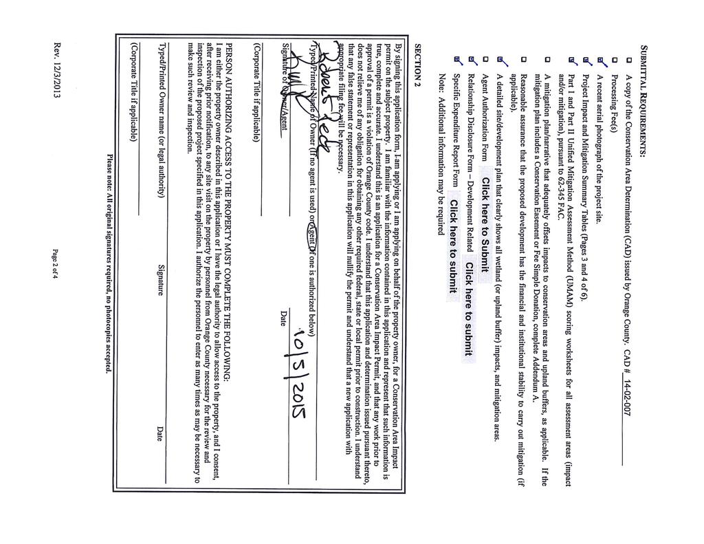
") Revised 11/2/2015 Owners Name: Agent: G & H International Investments LLC 1890 Kingsley Avenue Suite 102 Orange Park, FL 32073 Susan L. Fraser, SLF Consulting, Inc. 3517 Park Street Jacksonville, FL 32205
Revised 11/2/2015 Owners Name: Agent: G & H International Investments LLC 1890 Kingsley Avenue Suite 102 Orange Park, FL 32073 Susan L. Fraser, SLF Consulting, Inc. 3517 Park Street Jacksonville, FL 32205
CROWN POINT SUBDIVISION
 CROWN POINT SUBDIVISION A COMPARISON OF CONVENTIONAL VERSUS CONSERVATION SUBDIVISION DESIGN DEVELOPER: PAUL LUCIANO BUILDERS LAND PLANNING & DESIGN: DAVID LAIRD ASSOCIATES FUNDING PROVIDED BY: PA SEA GRANT
Michael D, Harvey, Current Planning Supervisor. This project was originally approved in 2012 by the BOCC and is summarized as follows:
 PLANNING & INSPECTIONS DEPARTMENT Craig N. Benedict, AICP, Director Current Planning (919) 245-2575 (919) 644-3002 (FAX) www.orangecountync.gov 131 W. Margaret Lane Suite 201 P. O. Box 8181 Hillsborough,
ARTICLE VI: SITE PLAN REVIEW
 Section 6.01 - Site Plan Review (All Districts) ARTICLE VI: SITE PLAN REVIEW Site plans give the Planning commission an opportunity to review development proposals in a concise and consistent manner. The
PROJECT SCOPE OF WORK CITY OF TOWN AND COUNTRY STORMWATER PROGRAM
 PROJECT SCOPE OF WORK CITY OF TOWN AND COUNTRY STORMWATER PROGRAM Project Name: 362 Featherstone Dr Project ID Number: 27-3 Problem: Anecdotal evidence suggests a natural spring exists in the backyard
Clarksburg Square Road Extension
 Clarksburg Square Road Extension Preliminary Plan No. 120140060 Site Plan No. 820140050 Site Plan Amendment No. 82007022C (Clarksburg Town Center) Clarksburg SPA Water Quality Plan Mandatory Referral MR2015008
Chapter 12 GENERAL STRATEGY
 GOAL: Vision: Section 163.3245, Florida Statutes "supports innovative and flexible planning and development strategies" through the Sector Plan process as a tool to encourage long-term planning for conservation,
The transportation system in a community is an
 7 TRANSPORTATION The transportation system in a community is an important factor contributing to the quality of life of the residents. Without a sound transportation system to bring both goods and patrons
Application Number: SD Project Name: Walton Farms Preliminary Subdivision (acting as Master Plan)
") STAFF REPORT Town of Clayton Planning Department 111 E. Second Street, Clayton, NC 27520 P.O. Box 879, Clayton, NC 27528 Phone: 919-553-5002 Fax: 919-553-1720 Planning Board May 22, 2017 Application Number:
STAFF REPORT Town of Clayton Planning Department 111 E. Second Street, Clayton, NC 27520 P.O. Box 879, Clayton, NC 27528 Phone: 919-553-5002 Fax: 919-553-1720 Planning Board May 22, 2017 Application Number:
KASPER. City of Georgetown, Texas PUD Planned Unit Development. December 30, 2015 Revised January 27, 2016
 KASPER City of Georgetown, Texas PUD Planned Unit Development December 30, 2015 Revised January 27, 2016 Applicant: Sentinel Land Company, LLC 4910 Campus Drive Newport Beach, CA Prepared by: SEC Planning
BYLAW C A Bylaw of Rocky View County to amend Land Use Bylaw C
 BYLAW C-7720-2017 A Bylaw of Rocky View County to amend Land Use Bylaw C-4841-97. The Council of Rocky View County enacts as follows: PART 1 TITLE This Bylaw shall be known as Bylaw C-7720-2017. PART 2
The following principles guide the development of goals and strategies to protect and promote these amenities:
 OPEN SPACE/PARKS/TRAILS/RECREATION GOALS/STRATEGIES Cherry Hills Village is a living environment that offers low density development, open areas, public scenic vistas, public trails and public parks. This
Application for Site Plan Review
 Application for Site Plan Review City of Pontiac Office of Land Use and Strategic Planning 47450 Woodward Ave, Pontiac, MI 48342 T: 248.758.2800 F: 248.758.2827 Property/Project Address: Sidwell Number:
PROJECT SCOPE OF WORK CITY OF TOWN AND COUNTRY STORMWATER PROGRAM
 PROJECT SCOPE OF WORK CITY OF TOWN AND COUNTRY STORMWATER PROGRAM Project ID Number: 25-5 Problem: Stormwater collected from the neighborhood upstream is released at 9 Muirfield Lane and flows west toward
CASE NUMBER: 16SN0701 APPLICANT: Hanky, LLC
 STAFF S ANALYSIS AND RECOMMENDATION Planning Commission (CPC) Public Hearing Date: MAY 17, 2016 CPC Time Remaining: 100 DAYS Applicant s Agent: DANIEL L. CASKIE (804-569-7060) Applicant s Contact: MICHAEL
WEST HILL BUSINESS PARK AREA STRUCTURE PLAN
 MUNICIPAL DISTRICT OF PEACE NO. 135 WEST HILL BUSINESS PARK AREA STRUCTURE PLAN Prepared by: TABLE OF CONTENTS 1.0 Introduction... 1 1.1 Purpose of Plan........ 1 1.2 Plan Area..... 1 1.3 Existing Conditions...
Town of Portola Valley General Plan. Nathhorst Triangle Area Plan
 Town of Portola Valley General Plan Amended December 10, 1997 Table of Contents Introduction... 1 Planning Area... 1 Objectives... 2 Principles... 2 Standards... 4 Description... 4 Community Commercial...
Essential Skills: Reading and Interpreting Maps and Plans
 Essential Skills: Reading and Interpreting Maps and Plans Prepared for: NYS Tug Hill Commission Local Government Conference March 31, 2016 Prepared by: Peter G. Vars, P.E. BME ASSOCIATES Stages of Plan
Staff Report Bourbon County Joint Planning Office SPECIAL MEETING September 4, 2018
 Staff Report Bourbon County Joint Planning Office SPECIAL MEETING September 4, 2018 Case Number: DVP 18-05 FINAL Applicant: Josh Cummins Location: Arlington Drive. Request: Car Dealer Parking Lot Zoning:
FORMOSA GARDENS PD. PD Revised January 24,2013
 FORMOSA GARDENS PD PD12-00027 Revised January 24,2013 Submitted to: Osceola County Community Development Department 1 Courthouse Square, Suite 1100 Kissimmee, FL 34741 Prepared for: Formosa Gardens Land
City Development Department 9500 Civic Center Drive Thornton, Colorado FAX
 City Hall City Development Department 9500 Civic Center Drive 303-538-7295 Thornton, Colorado 80229-4326 FAX 303-538-7373 www.cityofthornton.net Ben Swanson Dormie Capital Partners 3740 Dacoro Lane, Suite
AWH REPORT OF THE PLANNING AND DEVELOPMENT DEPARTMENT FOR APPLICATION FOR REZONING ORDINANCE TO PLANNED UNIT DEVELOPMENT
 AWH REPORT OF THE PLANNING AND DEVELOPMENT DEPARTMENT FOR APPLICATION FOR REZONING ORDINANCE TO PLANNED UNIT DEVELOPMENT MAY 8, 2014 The Planning and Development Department hereby forwards to the Planning
CONCEPT PLAN APPLICATION
 CONCEPT PLAN APPLICATION TOWN OF CHAPEL HILL Planning Department 405 Martin Luther King Jr. Blvd phone (919) 968-2728 fa (919) 969-2014 www.townofchapelhill.org Parcel Identifier Number (PIN): 9880267455
Article 20 Stormwater Management
 Article 20 Section 20.01 Intent Article 20 The purpose of this Article is to protect the health, safety, and general welfare of the citizens by requiring compliance with accepted standards and practices
MONTGOMERY COUNTY PLANNING DEPARTMENT THE MARYLAND-NATIONAL CAPITAL PARK AND PLANNING COMMISSION
 MONTGOMERY COUNTY PLANNING DEPARTMENT THE MARYLAND-NATIONAL CAPITAL PARK AND PLANNING COMMISSION MCPB Item No. Date: 3.10.2016 Site Plan 820160040 Nora School Parker Smith, Planning Technician, Area 1,
AREASTRUCTURE PLAN AMENDMENT COCHRANE NORTH
 AREASTRUCTURE PLAN AMENDMENT COCHRANE NORTH In order to implement the vision outlined in the Conceptual Scheme, the following three amendments to the Cochrane North ASP are proposed: 1. Allow commercial
CITY OF SCANDIA ORDINANCE NO. 174
 CITY OF SCANDIA ORDINANCE NO. 174 AN ORDINANCE AMENDING ORDINANCE NO. 122, THE SCANDIA DEVELOPMENT CODE, CHAPTER 2, SECTION 4.34, REGARDING SOLAR FARMS AND COMMUNITY SOLAR GARDENS The City Council of the
TOP TEN LIST OF COMMUNITY CONCERNS REGARDING PROPOSED AMENDMENTS TO CHAPTER 42
 TOP TEN LIST OF COMMUNITY CONCERNS REGARDING PROPOSED AMENDMENTS TO CHAPTER 42 1. Extend the urban area to Beltway 8 in stages, over say a three-year period, prioritizing development in transit and declining
13. PRELIMINARY PLAT NO MILLS FARM - Vicinity of the southeast corner of 159 th Street and Quivira Road
 13. corner of 159 th Street and Quivira Road 1. APPLICANT: HNTB Corporation is the applicant for this request. 2. REQUESTED ACTION: The applicant is requesting approval of a preliminary plat for a 383-lot
COLVER ROAD INDUSTRIAL CONCEPT PLAN
 COLVER ROAD INDUSTRIAL CONCEPT PLAN A CONCEPTUAL LAND USE AND TRANSPORTATION PLAN FOR TA-4 AN URBAN RESERVE AREA OF THE CITY TALENT City of Talent Adopted by City Council Resolution No., June, 2015 PART
Project: Developer/Designer: Reviewer: I. Narrative: 1. Project Description: Describes the nature and purpose of the land disturbing activity.
 City of Charlottesville, Virginia Erosion and Sediment Control Plan Review Checklist 610 East Market Street, Charlottesville, VA 22902 Telephone 434-970-3182; Fax 434-970-3359 Project: Developer/Designer:
LEVEL TWO UNIFIED PERMIT CHECKLIST FOR DETERMINATION OF COMPLETENESS [Devens Enterprise Commission Rules and Regulations 2018]
![LEVEL TWO UNIFIED PERMIT CHECKLIST FOR DETERMINATION OF COMPLETENESS [Devens Enterprise Commission Rules and Regulations 2018]](/thumbs/92/110164057.jpg "LEVEL TWO UNIFIED PERMIT CHECKLIST FOR DETERMINATION OF COMPLETENESS [Devens Enterprise Commission Rules and Regulations 2018]") LEVEL TWO UNIFIED PERMIT CHECKLIST FOR DETERMINATION OF COMPLETENESS [Devens Enterprise Commission Rules and Regulations 2018] Name of applicant and project: Date of Issuance of this DOC: List Regulatory
LEVEL TWO UNIFIED PERMIT CHECKLIST FOR DETERMINATION OF COMPLETENESS [Devens Enterprise Commission Rules and Regulations 2018] Name of applicant and project: Date of Issuance of this DOC: List Regulatory
PLANNING AND DEVELOPMENT DEPARTMENT SITE PLAN REVIEW SECTION / CURRENT PLANNING APPLICATION FOR PRELIMINARY SITE DEVELOPMENT PLAN APPROVAL
 PLANNING AND DEVELOPMENT DEPARTMENT SITE PLAN REVIEW SECTION / CURRENT PLANNING APPLICATION FOR PRELIMINARY SITE DEVELOPMENT PLAN APPROVAL Project Number City Development Number Application Date (Assigned
Urban Planning and Land Use
 Urban Planning and Land Use 701 North 7 th Street, Room 423 Phone: (913) 573-5750 Kansas City, Kansas 66101 Fax: (913) 573-5796 Email: planninginfo@wycokck.org www.wycokck.org/planning To: From: City Planning
ARTICLE IV: DEVELOPMENT STANDARDS 404 MASTER PLANNING
 IV 13 404 MASTER PLANNING Master Planning through the Site Analysis (Master Planning Site Analysis) or Planned Development (Master Planning Planned Development) is provided to encourage development which
McDonald s Restaurant - Purcellville Town of Purcellville Special Use Permit Statement of Justification July 24, 2014
 Introduction / Written Statement McDonald s Restaurant - Purcellville McDonald s Corporation is proposing to redevelop the existing McDonald s eating establishment with a drive-through located at 121 N
4. Contractor (and subcontractors if applicable) certification statement(s)
 certification statement(s)") CHEMUNG COUNTY STORMWATER COALITION STORMWATER POLLUTION PREVENTION PLAN (SWPPP) SUBMITTAL CHECKLIST GENERAL INFORMATION: 1. Owner/Operator name, legal address, phone number 2. Copy of signed Notice of
CHEMUNG COUNTY STORMWATER COALITION STORMWATER POLLUTION PREVENTION PLAN (SWPPP) SUBMITTAL CHECKLIST GENERAL INFORMATION: 1. Owner/Operator name, legal address, phone number 2. Copy of signed Notice of
ARTICLE 17 SITE PLAN REVIEW
 ARTICLE 17 SITE PLAN REVIEW 17.01 INTENT AND PURPOSE The intent of this section is to provide for consultation and cooperation between the applicant and the township planning commission so that the applicant
Red Fox Commercial Outline Plan
 Red Fox Commercial Outline Plan City of Cold Lake, Alberta Prepared by Durrance Projects Ltd and Ross W. Sharp & Associates Ltd October 2014 Rupert 1 Table of Contents 1. PURPOSE...3 1.1. Location...4
ARTICLE IX SPECIAL PERMIT USES
 ARTICLE IX SPECIAL PERMIT USES All special permit uses cited in Article IX and Attachment A of this Ordinance or any other Section of this Ordinance shall be subject to Site Plan Review. The procedures