Ottawa River North Shore Parklands Plan. April 2018
|
|
|
- Shanon Hilary Underwood
- 6 years ago
- Views:
Transcription


1 Ottawa River North Shore Parklands Plan April 2018
2 2
3 Ottawa River North Shore Parklands Plan April 2018 OTTAWA RIVER NORTH SHORE PARKLANDS PLAN 3
4 National Capital Commission Elgin Street, Ottawa, Canada K1P 1C7 Fax: Telephone: Toll-free: TTY: Toll-free TTY: Unless otherwise noted, all imagery is the property of the National Capital Commission. Unless otherwise noted, the photographs in this document illustrate existing conditions. To reduce environmental impacts, a limited number of printed reports have been produced. In lieu of additional printed copies, a PDF version of this plan can be downloaded at: 4 VERSION For approval by NCC Board of Directors April 19, 2018 DESCRIPTION DATE

5 Message from the CEO It is with great pride that I present the Ottawa River North Shore Parklands Plan. One of the key milestones outlined in the Plan for Canada s Capital, , is the transformation of the Capital s historic riverfronts into vibrant public parklands. This plan will help to realize this vision of improved shoreline access and lively waterfront areas. It provides an opportunity to reimagine and reconnect with the historic river culture that once defined the Capital, from the earliest Indigenous encampments, to the fur trade on the original Trans-Canada Highway, to the booming lumber industry that literally put the Capital on the map. This plan is the result of an extensive dialogue with many stakeholders in the public and private sectors, as well as the Indigenous community and shoreline property owners. There have also been three rounds of consultations to gather public input. This plan reflects many insights gained through this process. The Ottawa River North Shore Parklands Plan allows for a diverse range of activity along the river, including places for relaxation that emphasize the landscape and tranquil contact with the water, as well as different observation points providing views of Capital symbols and landmarks, and more dynamic and active sites in and around locations such as Jacques-Cartier Park, the Canadian Museum of History and Montcalm Street. It also honours the rich Indigenous history and culture of the Capital, highlighting Anishinabe archaeological sites, in partnership with the Indigenous community. It emphasizes the resilience of the shoreline, and supports the maintenance and renaturalization of the riverfront by ensuring that activities taking place near the water are adapted to the site s carrying capacity. The success of this plan will require continued close collaboration with the Ville de Gatineau and riverfront property owners, as well as federal partners such as the Canadian Museum of History. The plan will be implemented over several years, and the NCC will continue to consult with the public as the plan advances. I would like to thank and congratulate the NCC employees who worked on developing this creative vision for the north shore of the Ottawa River. Dr. Mark Kristmanson Chief Executive Officer OTTAWA RIVER NORTH SHORE PARKLANDS PLAN 5
6 Introduction Background Plan Objective and Scope Plan Development Process Historical and Planning Background Planning Framework Opportunities and Challenges: Urban Diagnostics 14 2 Vision and Concept Underlying Premises Vision The Role of Riverfront Lands and Land Use Concept Detailed Land Use Concept 20 3 Key Planning Features Environmental Protection Sites of Capital Significance Heritage and Archaeological Resources Water Access Recreational Opportunities and Attractions Shoreline Access Connectivity Events Winter Use Landscape Typologies 57 6
7 Sector Planning Jacques-Cartier Park North The Convent and Surroundings Jacques-Cartier Park South Canadian Museum of History Grounds Area Around the Kruger Plant Scott Point and Portage Park Riverfront Lands Near the Zibi Neighbourhood Mouth of Brewery Creek Brewery Creek (Montcalm Street Section) Brewery Creek Downstream (North of Hull Island) 97 5 Plan Implementation Plan administration Implementation tools Other factors to consider Updating the Plan Appendices 102 Appendix 1 Références 103 Appendix 2 Level of Event Intensity 104 Appendix 3 Strategic Environmental Assessment 105 Appendix 4 Federal Approval 107 OTTAWA RIVER NORTH SHORE PARKLANDS PLAN 7
8 8 1.1

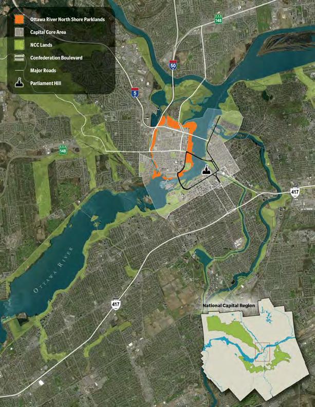
9 1 Introduction GETTING TO KNOW THE RIVERFRONT 1.1 Background Riverfront lands in the Capital s core area run adjacent to urban neighbourhoods in Gatineau and many and key federal government landmarks. These lands are an important part of downtown Gatineau s green infrastructure, providing open spaces that can accommodate large public gatherings. They also provide a natural environment along the riverbanks. A number of regional stakeholders have varied interests in these lands, and it is therefore important to ensure proper coordination of how these riverfront areas are used. The National Capital Commission s (NCC) planning mandate is established under the National Capital Act, which confers upon the NCC the responsibility for planning, developing and improving the Capital and, more specifically, federal lands. Capital core area riverfront lands are largely federal property, as shown on Map 1.3. The vast majority of these lands are part of the National Interest Land Mass (NILM), which consists of land that has been identified as key to the NCC s long-term mandate. 1.2 Plan Objective and Scope The objective of the Ottawa River North Shore Parklands Plan is to guide development decisions by basing them on a long-term vision. The plan proposes land uses and design guidelines for federal lands in the study area that will contribute to achieving that vision. The plan is meant to guide development projects and activities on federal lands. It will also serve as a decisionmaking tool for federal approvals regarding land use, design and real estate transactions. Aerial view of Ottawa River and Hull Island shorelines (2012) OTTAWA RIVER NORTH SHORE PARKLANDS PLAN 9
10 Study Area and Sectors Sectors Jacques-Cartier Park North Convent area Jacques-Cartier Park South Canadian Museum of History grounds Area around Kruger plant Scott Point and Portage Park Riverfront lands near the Zibi neighbourhood Mouth of Brewery Creek Brewery Creek Montcalm Brewery Creek North of Hull Island Points of Interest Leamy Lake Rideau Falls ByWard Market Parliament Hill Canadian War Museum M
11 1.3 Study Area The study area includes federal lands in the Capital core area that run along the periphery of Hull Island in Gatineau, between the Ottawa River and Laurier Street. It also includes private properties that are in the process of being purchased. The plan also covers the federal lands along Ruisseau de la Brasserie (Brewery Creek). These lands encompass the following: Jacques-Cartier Park North (A) and South (C); the convent and surrounding areas (B); Canadian Museum of History grounds between the building and the river (D); areas around the Kruger plant, all the way to the Portage Bridge (E) (F); riverfront lands between the Portage and Chaudières bridges (G) the combined area of Portageurs Park, Montcalm-Taché Park and the Wright-Scott House (H) lands located between Brewery Creek and Montcalm Street (between Wright Street and 135 Montcalm) (I) lands along Brewery Creek between the Hwy. 5/50 and Fournier Boulevard bridges (J). The plan also outlines the NCC s wishes regarding the development or use of certain adjacent non-federal lands, which would help achieve the objectives of this plan. Suggested points of consideration are provided and could be discussed in greater depth with property owners and the Ville de Gatineau, with a view to potentially establishing partnerships. These lands include the following: Riverfront lands that are part of the Ottawa River and Brewery Creek riverbeds; the natural area adjacent to the west end of Portageurs Park (Hydro-Québec) the Hydro-Ottawa lot (or land) adjacent to Trou du Diable (Devil s Hole) falls fenced-in areas at the Kruger plant. 1.4 Plan Development Process Each stage of the development process involved extensive consultation with regional organizations, as well as the public. Given the large number of stakeholders in the development and use of these riverfront lands, combining their multiple interests into a cohesive whole was challenging. A consultation report has been produced which outlines the comments received. The plan was developed in a three-phase process. Phase 1 Analysis and research: Gathering pertinent information from various documents, the public and various regional organizations; defining the widely varying perceptions of the sites. Phase 2 Vision and general policies: Formulating the roles of riverfront lands and preliminary vision statements; presenting these in public consultations and to regional organizations. Phase 3 Development plan: Writing a draft plan based on comments received; posting it online in order for the public and regional organizations to comment. The plan also benefited from directions suggested by the Advisory Committee on Planning, Design and Realty and the newly created Ad hoc Advisory Committee on the Activation of the North Shore of the Ottawa River. The plan development process was carried out in parallel with a strategic environmental assessment, which is used to systematically assess the environmental impacts of projects and ensure that environmental, social and economic issues are factored into the decision-making process as early as possible. A summary of the strategic environmental assessment is provided in Appendix Historical and Planning Background Sites Steeped in History The Ottawa River, which runs through the study area, stretches more than 1,270 kilometres, and makes up one of the largest river systems in Canada. The river was the main factor in the region s settlement and development. The unique geography created by the confluence of the Gatineau, Rideau and Ottawa rivers, and the presence of the Chaudières Falls (Akikodjiwan), made the area a natural meeting place for trade and exchange for millenniums. The natural harbours of the north shore, for example, offered stopping and portage points between the current location of the Portage and Macdonald-Cartier bridges in the very heart of the current Capital Region. OTTAWA RIVER NORTH SHORE PARKLANDS PLAN 11

12 Land Ownership Owner NCC Other Federal Agencies Points of Interest Rideau Falls Parliament Hill Canadian War Museum Sectors Jacques-Cartier Park North Convent area Jacques-Cartier Park South Canadian Museum of History grounds Area around Kruger Plant Scott Point and Portage Park Riverfront lands near the Zibi neighbourhood Mouth of Brewery Creek Brewery Creek Montcalm Brewery Creek North of Hull Island M 12
13 According to oral tradition and archaeological findings, Algonquin presence in the region dates back over 8,000 years. The settlement of Algonquin peoples was also noted by the first Europeans who arrived in the 17th century. The Anishinabe (called the Algonquin by Champlain) also helped the Europeans explore the Ottawa River, which would lead them to the heart of the continent and become a key component of the fur trade. At the turn of the 19th century, the demand for lumber spurred on the logging industry, and use of the river for log driving. To get around the Chaudières Falls, the Wrights, one of the first families to settle in the region, built a timber slide, which ran along what is now Laurier Street, between Eddy Street and Scott Point. With hydro power from the river, the first sawmills were established in the region. Over the course of the century, the number of sawmills multiplied and their use diversified because of demand. Later, sources of power other than hydro were introduced, but the river continued to be used for log transport. The sawmills and associated storage areas gradually came to occupy most of the riverfront lands. Throughout the 19th century and a large part of the 20th century, the riverfront landscape was heavily marked by the forestry, pulp and paper, and other related industries such as boat manufacturing for log driving operations. The river was also important to the general public, who used it to travel to the Montréal region before the railway reached Ottawa (around 1860). For many years, the link to Ottawa was provided by ferries. Bedard s Landing, as it was known at the time, near the current Canadian Museum of History, provided a place for ferries to dock and travellers to board from the nearby inn. The choice of Ottawa (known as Bytown until 1855) as the capital of Canada brought about gradual changes in the riverfront landscape, first through the construction of the Parliament Buildings, then through the gradual replacement of the lumber mills. A Legacy to Build On This plan is in keeping with the Capital improvement mandate a mandate originally conferred upon the Ottawa Improvement Commission (1899), and carried on by successive planning bodies, through to the NCC, which was created in Every plan developed by these bodies promoted shoreline restoration in order to surround the river in greenery. The Gréber Plan recommended creating a network for riverfront experiences on shorelines free of polluting industries that marred the Capital s central landscape. From the 1960s to the 1980s, the Government of Canada stepped up the land acquisition process it had begun in 1933, transforming the river s north shore. Waterfront parks were created and developed, and large museums were built on both sides of the river. The 1988 Federal Land Use Plan and the 1999 Plan for Canada s Capital set out the desired uses for federal lands, and NCC lands in particular. They also discussed ecological aspects of development. As part of the implementation of these plans, strategically located lands were set aside for the future establishment of national institutions or the hosting of major NCC festivals. In 2005, Canada s Capital Core Area Sector Plan confirmed and clarified the NCC s intent with respect to development, and offered a vision structured around three themes: celebrate, connect and consolidate. Since then, the vegetation has been re-established, creating a lush, green landscape on a large part of the Ottawa River shoreline in the National Capital Region, with the exception of the Kruger plant site. The lands surrounding the ruins of the Domtar mill will be redeveloped into a mixed-use urban neighbourhood, which will reconnect with the shoreline and create a more vibrant sector. OTTAWA RIVER NORTH SHORE PARKLANDS PLAN 13

14 1.6 Planning Framework The Ottawa River North Shore Parklands Plan outlines general and detailed policies governing the development and use of federal lands around Hull Island. The development proposals contained in this document also reflect the NCC s strategic directions. These lands are within the boundaries of the Capital core area, as defined in the NCC planning framework. This plan therefore falls under Canada s Capital Core Area Sector Plan (NCC, 2005) and the Plan for Canada s Capital, This latest plan updates the major founding principles of the 1999 and 2005 plans. It confirms the desire to create healthy, welcoming, vibrant places, and to make the river a unifying element in the region. It highlights the importance of linking urban environments to the river s shore, and ensuring that the shore is accessible to the public and that it remains within the public domain. In a growing region like the Capital, riverfront areas are an invaluable treasure. Strengthening the green and blue networks will promote the region s resilience and contribute to sustainable development that integrates culture, economy and ecology. 1.7 Opportunities and Challenges: Urban Diagnostics The rich history of successive occupancies of this area, new land uses, the location adjacent to urban neighbourhoods, and the desire to access waterways imbue these riverfront lands with multiple identities which present both challenges to be overcome and development opportunities to be seized. The summary of challenges and opportunities is based on various rounds of consultations conducted with the general public and partners, readings of past and current studies and plans from the NCC and the Ville de Gatineau, and historical and archaeological evaluation assessments. Summary of Opportunities and Challenges SYMBOLIC NATURE Although a key component of a highly symbolic area, the Ottawa River shorelines are also seen as places of activity in the Capital. A balance needs to be achieved between enriching the riverfront experience and preserving the distinction and status of the Parliamentary Precinct. CONNECTION TO THE URBAN FABRIC Landscape treatments that are intended to delineate park boundaries can have the effect of cutting the park off from adjacent neighbourhoods, and preventing these green spaces from being fully integrated into the urban fabric. Also, Confederation Boulevard, the Capital s ceremonial and discovery route, is not connected to the riverfront. The ongoing urban intensification of mixed-use areas around riverfront parks contributes to greater use of the sites and more sustained activity. Without losing sight of the role of riverfront lands in the Capital, improved permeability between shoreline Land Zoning ( Programme particulier d'urbanisme - Ville de Gatineau ) Multi-Function Institutional Commercial Residential Study Area
15 areas and the adjacent urban fabric would contribute to increased use of the space at times when no events are being hosted. BALANCING LEVELS OF ACTIVITY AND SITE CARRYING CAPACITIES By their very nature, large parks with open spaces do not attract people, and the large parks as they are currently developed lose their appeal during times when there are no programmed events. Organized events requiring controlled access necessarily result in reduced public accessibility to certain areas. A balance must be achieved in this regard. Riverfront lands and shorelines provide excellent opportunities for passive recreation and activities of a contemplative nature. The intent to provide increased levels of activity in certain locations must take this into account. Surface degradation that can occur on riverfront lands as a result of too many events in close succession limits the sites carrying capacity and, therefore, their use in animating the core area of the Capital. If the number of events is to be increased, new venues should be considered. Jacques-Cartier Park North could serve as a new venue, but its potential for hosting events is currently limited by location and access issues, as well as by a lack of infrastructure. The ability to use certain sites may be limited by increased project costs due to contamination issues. New activity sites may be developed progressively, according to the stakeholders ability to pay for cleanup costs. Few existing parks include a pathway that can be used to provide a detour when the main recreational pathway is closed during an event. The presence of Canada geese limits the use of lawn areas. Various deterrent methods are being explored. INTERACTING WITH THE RIVER Increasing the offer of riverfront recreational activities will contribute to creating a more lively and dynamic capital. However, this must be achieved in keeping with the objective of protecting the natural features of the shoreline and the natural environment. There is no boat launch for non-motorized watercraft. The planning of any new launches must also include the provision of nearby parking. Many of the shoreline areas near existing parking lots have a gentle slope down to the water s edge, which is ideal for water access and riverfront activities requiring the transport of marine equipment. The poor quality of installations around the Hull Marina and the presence of spaces that convey the sense of a semi-private facility are not conducive to the creation of an activity site. The noise generated by vehicles travelling on the steel deck of the Alexandra Bridge hinders the attractiveness of the site surrounding the wharf, marina and lower section of Jacques-Cartier Park South. VISUAL QUALITY Any improvements to the view of the Ottawa River from riverfront lands must take into consideration the need to preserve the vegetation cover of the landscape, as seen from the Ottawa side. Managing invasive species can prove to be a complex undertaking, especially in places where these species represent the majority of plants on the shoreline. Parks require adequate lighting for nighttime use. Any lighting improvements on federal lands must consider the potential impact on visual harmony, as seen from the Ottawa side. The addition of hard surfaces can offset damages that come with the installation of stage facilities, but can also have an impact on a park s green and natural character. CONTINUOUS PUBLIC ACCESS TO THE RIVERFRONT The rehabilitation of the Domtar lands presents an opportunity to reclaim one of the final sections of shoreline remaining under private ownership, and make it publicly accessible. The closure of the access between the Kruger plant and Eddy Street, as part of the Windmill urban development project, could open the door to the rehabilitation of the area east of the Portage Bridge, and provide access to Scott Point. The Zibi neighbourhood development plan does not include a riverfront connection between the Domtar lands and Portageurs Park. Collaboration among partners to preserve a recreational riverfront corridor would be desired. The construction of the last links in the recreational pathway network at the northern end of Hull Island would provide a complete loop around the island. However, this area includes environmentally sensitive sites. OTTAWA RIVER NORTH SHORE PARKLANDS PLAN 15


16 2 Sunset boat tour on the Ottawa River, in front of Jacques-Cartier Park North. A destination for people and communities, in the core of a resilient, green capital
17 2 Vision and Concept IMAGINING THE RIVERFRONT 2.1 Underlying Premises This plan follows a few basic premises derived from the Plan for Canada s Capital, , the Capital Core Area Sector Plan (2005) and the NCC s strategic directions. According to these basic premises, riverfront lands should offer places for Canadians, and remain in the public domain; be developed in such a way as to reflect the significance of their location within the nation s capital; be managed and developed in a way that contributes to the region s resilience; provide access to waterways in the Capital core area; and conserve the Capital park function for lands designated as such in the Capital Core Area Sector Plan. 2.2 Vision The riverfront lands on the north shore of the Ottawa River are a 21 st century waterfront destination and a key part of the Capital Region s shoreline revitalization efforts. These lands constitute A destination for people and communities, in the core of a resilient, green capital The riverfront lands around Hull Island will continue to be community places of great significance for the Capital, residents of the region and all Canadians. They will continue to be for public use, and will be very inviting for residents and visitors who are drawn to the scenery and waterways of the Capital core, and seek to enjoy the tranquility of its natural spaces. These lands will be places where people can gather, celebrate, contemplate, relax, have fun and commemorate the past. Some of the more active sites will be showcased, to contribute to the vibrancy of the Capital core area. Sites on riverfront lands will be developed to highlight the important role of Algonquin communities. These areas will be places of living memory that tell the story of the region, and are a physical testament to the Algonquin presence and activities of the past that fostered the development of the Capital Region. Riverfront lands offer a rich, natural environment in the heart of the Capital s urban setting. They provide natural habitats for a number of species, and contribute to river ecosystem health, water quality and the resilience of the region. In addition to providing enjoyment for residents and visitors alike through their lush, green landscapes, these spaces represent the important place that nature holds in Canada. While preserving their important ecological functions, riverfront lands will also be places where one can admire scenic views of Capital symbols, and will be well-used parks that offer a variety of recreational and cultural opportunities. A balance must be struck between the use of these lands and the need to conserve and enhance their environmental, cultural and historical value. High-quality improvements and environmentally friendly recreational opportunities will enhance the user experience. OTTAWA RIVER NORTH SHORE PARKLANDS PLAN 17

18 Riverfront areas are where Capital landmarks meet the vibrant urban life of Hull Island. Efforts will continue to be made to bring riverfront properties back into the public domain, and incorporate them into the urban park system. Offer a wide range of experiences 2.3 The Role of Riverfront Lands and Land Use Concept The land use and development concept is based on the different roles the lands play. The lands in question are basically parks that include natural spaces. This means that special precautions must be taken to protect them. Accessible areas of the Ottawa River s north shore are also uniquely located, and can provide recreational spaces where people can engage in varying levels of activity depending on the site. Through the vision presented in this plan, and the proposals put forward in this land use plan, the following four roles are identified for riverfront lands. ROLE 2.1 Riverfront lands are attractive public places offering various opportunities for contemplation, recreation and cultural activities. These parks and activity sites offer a wide variety of waterfront experiences and landscapes for a broad audience. These spaces are conducive to relaxation, social interaction, cultural experiences and large gatherings. Riverfront areas give people opportunities to discover and take full advantage of the beauty and features of the Capital core area. The spaces are oases of greenery in the Capital core area, which provide public access to waterways. For some residents, they also provide green spaces close to home. Riverfront lands form a series of public parks where activity levels vary depending on the site. More vibrant activity areas will be developed in Jacques-Cartier Park North and South, at the Canadian Museum of History, and along Montcalm Street. Other riverfront spaces will provide relaxation areas, with an emphasis on the landscape, greenery and tranquil interaction with the waterways. These spaces, typically for more spontaneous, everyday use, will be generally equipped with more basic facilities. The appeal of public parks will be enhanced by the introduction of new recreational amenities for users at the more active sites. 18

19 Provide access to the river Showcase the symbolism of the Capital ROLE ROLE These lands, which are accessible to the public, provide visual and physical contact with the waterways. Access will be facilitated by a network of pathways through an expanded riverside corridor, which will link the sites. Some loops will include the Macdonald-Cartier and Chaudières bridges, while others will run the full length of Brewery Creek, providing a complete loop around Hull Island. A variety of options to experience the river will be offered, ranging from areas for quiet contemplation to nautical activities. Facilities and activities will make it possible for users to take full advantage of the surrounding riverfront landscape. Enhancements to the river s visual and recreational experiences will be a benefit for the region. The riverfront route will also connect to existing cultural, tourist and recreational trails in downtown Gatineau and Ottawa. Riverfront lands are also the connection between the river and the urban fabric, ensuring permeable access from Laurier Street. This function will be served through an increase in the number of riverfront sites accessible to the public and through simple, clear and inviting entrances to riverfront lands. Riverfront lands play a symbolic role in the core area of the Capital. Public parks form a route that complements Confederation Boulevard and leads around the Capital core s central river basin. This route offers exceptional views of the Capital s iconic built and natural features. Among these features are the Parliamentary and Judicial precincts overlooking the Ottawa River, as well as the prominent natural settings around them. The view of the north shore from the Ottawa side is also part of the landscape that frames the river and contributes to the imagery of the Outaouais region. These north shore lands are steeped in history, and developments and land uses will be sensitive to the sense of place that these lands convey. Today, we can still see the role these lands played for First Nations and voyageurs who navigated the river and would stop along the shoreline, owing to the ease of access offered by the gentler slope of the riverbank. One can also imagine these lands during the industrial past, as a few buildings remain to illustrate the significance of these past industrial activities. There are a host of riverfront landscapes. They tell the region s story, and offer opportunities to showcase spectacular views of the Capital s symbolic features and the natural river setting. OTTAWA RIVER NORTH SHORE PARKLANDS PLAN 19

20 ROLE Detailed Land Use Concept The four roles come together to create a detailed land use concept aimed at achieving the vision of creating a destination in the Capital core area. Riverfront lands will be used to create a series of interconnected public spaces highlighted by the Capital landscapes and natural environment bordering the river. Riverfront lands will form a network of parks and public spaces offering a number of activity areas, each with their own character. Different sites will be developed for different activity levels, and each site will have its own particular feel. Riverfront lands will contribute significantly to the quality of the Capital core area s landscape and aesthetics. Enhance the natural environment The parks natural features provide habitat for a number of species, and are an integral part of the Ottawa River s vast ecosystem, which runs through Canada s Capital Region and links natural habitats. Further planting is needed in parks and on other riverfront lands to enhance the urban forest cover and strengthen the riparian strip. An iconic feature of the Capital is the natural landscape along the river. Strengthening the riparian strip and planting shoreline vegetation will help enhance the visual quality in certain areas and create continuity in terms of green space in the Capital core area. Natural features constitute a tangible and intangible collective richness. They provide cultural services, such as recreation and tourism, as well as aesthetic, educational and cultural benefits that are important for a community. In an urban area, the natural environment offers interpretation opportunities to build public awareness about the benefits it provides our living environment through the various ecosystem services it provides, such as regulating air and water quality. The natural shoreline environments enhance our resilience to sudden shocks caused by flooding, and help to reduce soil erosion. RIVERFRONT LANDS ON THE NORTH SHORE OF THE OTTAWA RIVER WILL INCLUDE THE FOLLOWING: 68.8-hectare study area 28.3 hectares of landscaped, multi-use parks 39.6 hectares of natural park, of which 27.7 hectares is urban forest 6.2 kilometres of vegetated shoreline an activity hub at the Alexandra Bridge exit six sites for hosting events a balanced sequence of tranquil and animated sites seven sites dedicated to the addition of new recreational services for users a complete waterfront route around Hull Island (7.4 kilometres), including the addition of 1.6 kilometres of new pathways 10 hectares of newly accessible lands a series of water access points new water access points for non-motorized boats an enhanced Capital panorama and landmarks a showcase of the region s history and heritage improved links to the river from adjacent neighbourhoods. 20
 Improved Animated Street Multi-use Park Space Special Study Area")
21 Concept Plan Capital Entry Point Services and Institutions Clubhouse and Services Building Multi-use Pathway Existing/Proposed Symbolic Core River Area Event Space Marina Paddling Route Vibrant Area Animated Public Space Riverfront Rest Point Animated Street Natural Park Space Mixed Services & Park Space Boat Launch (NON-MOTORIZED) Improved Animated Street Multi-use Park Space Special Study Area Urban Links Improved Pedestrian Link (MONTCALM) OTTAWA RIVER NORTH SHORE PARKLANDS PLAN M 21

22 Winter activities near Maison Charron. 3

23 3 Key Planning Features GUIDING THE ENHANCEMENT OF RIVERFRONT LANDS The implementation of the vision and concept for the riverfront lands will ensure cohesiveness between the parks various functions and the broad range of experiences sought by different users. The following maps illustrate the desired future status of the riverfront lands. The various functions are presented thematically and, when brought together, form the detailed land use concept. The maps show possible areas for implementing the various proposed functions of the riverfront lands, as well as the boundaries within which each of these functions can take place without interfering with the others. The maps should be viewed as closely linked, interdependent components, each taking the content of the others into account. They illustrate the conceptual and logistical planning considerations that need to be respected in the future development of these sites. Their use will help ensure that the different roles played by riverfront lands can be incorporated in a balanced way, so as to achieve the long-term objectives for this area and guide the planning proposals presented in Chapter 4. MosaïCanada 150 exhibit in Jacques-Cartier Park South OTTAWA RIVER NORTH SHORE PARKLANDS PLAN 23
24 Environmental Protection 100-year Flood Plain Urban Forest Meadow Vegetation Riparian Vegetation Fish Migration Route Proposed Fish Ladder M


25 3.1 Environmental Protection Function: Support and protect rich and sustainable urban biodiversity. ROLE Riverfront lands and shoreline vegetation are part of the broader Ottawa River ecosystem. The river serves as a link, particularly for fish habitat and shoreline wildlife. The riverfront lands covered by this plan are therefore linked to the natural environments located upstream, downstream and on the opposite shore. They affect water quality and aquatic habitats. The wooded areas on the riverfront are part of a network of vegetation areas that are critical to wildlife. They are connected to Leamy Lake Park, Gatineau Park, the island sector and the Deschênes Lake Important Bird Area (IBA). Thus, the natural components of the riverfront lands support the region s resilience, promote biodiversity, provide stable natural habitats for many species, including species at risk, and serve a number of ecological functions that are highly beneficial to us. These natural environments must be protected and expanded, and their status improved. Management of these riverfront lands is part of the government s efforts to support sustainable development and reduce the adverse environmental impacts of activities conducted on its properties. 5 Adjacent Natural Areas Lemay Lake Park 4 2 Gatineau Park 5 3 Voyageurs Corridor Important Bird Area at Deschênes Lake Kettle Island Land, riparian and aquatic natural environments Help implement recovery plan measures for federally and provincially listed species at risk. Use nighttime lighting that is sensitive to animal species, and create shaded areas, as indicated in the Capital Illumination Plan, Recognize the importance of wilderness for insect, butterfly and migratory bird nesting. Maintain wilderness areas along the shoreline, and limit human traffic in these areas. Develop wildlife corridors to promote connectivity between land environments, wetlands and the river. Control invasive plants in the riparian strip, natural environments and potential habitats of species at risk. Implement measures to prevent the spread of aquatic invasive species in areas around boat launches. Protect and enhance plant and animal habitats. Expand natural habitats in the riparian strip and aquatic habitats. Improve the habitat status for species at risk. OTTAWA RIVER NORTH SHORE PARKLANDS PLAN 25

 and heritage trees. Ensure the presence and good health of street trees.")
26 3.1.2 Forest cover Conserve and enhance the urban forest cover. Target the canopy indices set out in the NCC s tree strategy. Identify replacement planting areas to preserve the landscapes and appropriate tree canopy coverage for the area. Replace vegetation in a way that gradually creates appropriate landscapes for the desired land uses, in order to maintain continual forest cover. Conserve and protect special trees (DBH [diameter at breast height] of 50 cm or more) and heritage trees. Ensure the presence and good health of street trees. Enhance the quality of wooded areas by ensuring the presence of three layers of vegetation; reducing invasive plants; ensuring a succession of native species; reducing the number of informal pathways. Apply replacement ratios or implement compensation measures for felled trees according to the policy in effect and taking into account their ecological (ecosystemic), landscape or symbolic value. Reduce heat islands by planting trees. Protect trees during activities organized in the parks Water quality and erosion management Reduce shoreline erosion by controlling and slowing down stormwater runoff; managing shoreline forest cover to reduce sediment detachment; expanding the coverage of shoreline vegetation; using bioengineering techniques to reinforce riverbanks; 26

27 collaborating with the appropriate agencies to limit boat speed in order to reduce wakes and shoreline erosion; monitoring the physical condition of the shores. Manage surface water runoff. Manage runoff from new developments, by using bioretention basins to retain and filter water; creating parking lots with porous surfaces in accordance with best practices approved by the NCC. Preserve the quality of wetlands and riverside environments when modifying park surface drainage. Limit contaminants. Secure sites that have contaminated soil. Manage the presence of Canada goose flocks by modifying the habitat and adapting vegetation maintenance programs. Stay abreast of best practices in Canada goose population control Riparian strip Restore the natural riparian strip. Provide public access to the water by allowing land uses that comply with the Politique de protection des rives, du littoral et des plaines inondables du Québec [The Province of Quebec s policy for the protection of shorelines, riverbanks and flood plains]. Maximize the presence of vegetation along the shore, comprised of a 15-metre buffer zone from the natural high water line. Limit and, where possible, replace existing grassy areas in the riparian strip. Replant using native species that support the natural living environment. When desirable, restore transformed shorelines using bioengineering techniques adapted for the strength of the current and changing river levels. Protect existing aquatic grass beds, and support projects designed to increase their area Education and awareness Educate the public about the importance of natural capital. Educate the public about the ecological functions served by urban natural environments. Provide discovery pathways and green walkways where visitors can ponder the natural, riverfront and aquatic environments, and offer interpretation activities for natural features. Promote quality management of riverfront areas and exemplary management practices Energy efficiency and sustainable site management Apply best practices in energy and resource consumption. Plan, design and build federal facilities in accordance with the Federal Sustainable Development Strategy. Ensure that proposed design solutions are reliable over the long term and can be economically maintained. Design building architecture in a way that reduces bird collisions. Reduce water consumption in sanitary, cultural and recreational facilities. Plan the installation of electric vehicle charging stations for the public and maintenance contractors. Encourage reduced energy consumption during activities held on NCC lands. Ensure responsible waste management during activities held on NCC lands. OTTAWA RIVER NORTH SHORE PARKLANDS PLAN 27

28 Sites of Capital Significance Symbolic Core River Area Natural Landscape Capital Entry Point Key Sightlines Panoramic Views Significant Buildings of the Capital Confederation Boulevard M

29 3.2 Sites of Capital Significance Function: Showcase the symbolism of the Capital as the seat of government and a place that is rich in history. ROLE The riverfront lands prime location demands uses and design that will showcase the Capital s defining features and prove fitting for this prestigious setting. The NCC promotes design excellence in the built environment and landscapes as a foundation for the ongoing beautification of the Capital. The region s abundant vegetation that can be seen upon entering the Capital core area, as well as the Gatineau region, gives the Capital its unique, lush, green character and is indicative of the important place that nature holds in Canada. The river makes it possible to admire countless points of interest in the Capital core area and key landscapes that define the Capital s identity. Enhancements must also highlight the defining landmarks of our identity, both current and historical Design excellence and reflection of the Capital SCENIC VIEWS DESIGN QUALITY Choose a design that contributes to the quality of the development and properly reflects the prestige of the seat of government. Promote high-quality architecture for buildings and facilities. Help implement the Capital Illumination Plan, SENSE OF PLACE Encourage a design suited to the spirit of the place, to foster a variety of experiences. Factor in the river s presence by highlighting a connection to the water. Draw inspiration from each site s history, inhabitants and successive uses. Build on themes associated with the place and how the site is used. Contribute to the Ottawa River s cultural landscape by designing sites that reflect the river s role for First Nations; in settlement, exploration, the fur trade and the logging industry; in the building of the Capital. Highlight Capital landmarks in the core area. Preserve the scenic views of Capital landmarks, including the Parliamentary and Judicial precincts, buildings reflecting the Capital s growth, waterways, defining panoramas, and national cultural institutions. Preserve the riverfront lands that offer the best views. Ensure the quality of improvements made to these locations. Develop new lookout points on riverfront lands as part of the development of Capital discovery corridors. On federal lands, implement the recommendations from the document entitled Canada s Capital Views Protection and its updates. OTTAWA RIVER NORTH SHORE PARKLANDS PLAN 29

30 30 Exterior grounds of the Canadian Museum of History.
.")
31 COMMEMORATIVE MONUMENTS On riverfront lands, allow the installation of commemorations that contribute to the country s and the Capital s identity. In close collaboration with Canadian Heritage, update Canada s Capital Commemoration Strategic Plan (2006). Ensure that detailed plans integrate the sites for commemorative monuments, as recommended in the updated strategic plan. Install commemorative monuments in such a way that they serve as points of interest and gathering places within the parks and contribute to the general (daily) use of these sites. Select sites that provide an appropriate ambiance for the subject being expressed by the commemorative monument. On festival and event sites, commemorative monuments should be erected outside of the designated festival and event areas. Encourage commemorative monuments to be illuminated in accordance with the Capital Illumination Plan, Riverfront landscapes and entry points RIVERFRONT LANDSCAPES Contribute to the Capital core area s characteristic natural landscape by focusing on the continuity of natural vegetation on both riverbanks. Revegetate the segments of shoreline that have been stabilized (with rip-rap) against erosion, while also maintaining reinforcement where needed. Reintroduce tree species that are reminiscent of the vegetation that was present in pre-european times (e.g. white pine). Continue to conduct visual quality assessments of the landscape, and incorporate areas requiring improvement into site plans. ENTRY POINTS Develop and enhance the lands around Capital core area entry routes, to make them distinctive. Improve the land around the Alexandra, Portage, Chaudières and Macdonald-Cartier bridges and the land visible from the bridges to enhance the aesthetics of Capital core area entrances. Factoring in the particular features of Confederation Boulevard, align its improvements with those marking the transition to the urban fabric of the city of Gatineau. Preserve the river s iconic, lush green landscape between the mouth of Brewery Creek (to the north) and the Rideau Canal locks, which is a gateway to the Capital that can be seen by visitors arriving from Montréal by boat on the Ottawa River. Voyageurs Pathway, along the convent lands. OTTAWA RIVER NORTH SHORE PARKLANDS PLAN 31
32 Heritage and Archaeological Resources Archeological Site Zone of Archeological Potential (PRE-CONTACT) Ossuary Potential Site Federal Heritage Building Building of Heritage Interest M

33 3.3 Heritage and Archaeological Resources Function: Use historical, cultural and archaeological resources to create a place that tells the story of the region s evolution and that supports the dissemination of this knowledge. ROLE Some historical buildings help us to better understand the history of particular sites. The Ottawa River s north shore has a multitude of archaeological and historical sites reflecting thousands of years of history, where visitors can discover, experience and learn about past, as well as more recent, events that have shaped the region s character. These sites some of which are not well known are part of our identity, offering visitors a rich experience through an interpretive cultural route aimed at expanding understanding of the region s evolution. Responsibilities for interpretation, commemoration and public art are shared between the NCC and Canadian Heritage. The NCC is responsible for identifying sites on federal lands and approving planning around interpretation sites. In parallel with the directives administered by Canadian Heritage, the following policies are to be applied for the development of interpretation sites Archaeology and heritage ARCHAEOLOGY Protect and showcase archaeological artifacts and resources. Avoid disturbances on top of known archaeological sites as much as possible. Develop a strategy that places priority on managing sites that are prone to erosion and may contain artifacts. Conduct research to more accurately determine the extent of known archaeological sites. Manage known archaeological sites in collaboration with the Algonquin peoples and in accordance with the Protocol for the co-management of archaeological resources (2017) and Parks Canada s Cultural Resource Management Policy. Recognize and promote the educational value of archaeology and heritage. Develop sites in a way that gives visitors a period-based cultural experience reminiscent of one of the region s bygone eras. Together with Canadian Heritage and the Algonquin community, develop a discovery program based on archaeological and historical resources. Pass on knowledge about how these lands were used and about ways of life and adaptation methods. Among the knowledge to be disseminated, include geomorphology, the landscape s evolution and the factors that led to the occupation of the region. Where possible and appropriate, include in situ artifacts in interpretation programs. HERITAGE Preserve heritage and cultural landscapes of Capital significance. Commemorative plaque at the Hull wharf. Apply appropriate standards to initiatives involving heritage sites, in accordance with the following documents, among others: Standards and Guidelines for the Conservation of Historic Places in Canada; Building resilience: Practical guidelines for the sustainable rehabilitation of buildings in Canada Treasury Board s Policy on Management of Real Property and the Treasury Board Heritage Buildings Policy; Federal Heritage Buildings Review Office (FHBRO) Code of Practice; and Quebec Cultural Heritage Act and related municipal policies. OTTAWA RIVER NORTH SHORE PARKLANDS PLAN 33

34 E.B. Eddy Digester Tower, Canadian Museum of History grounds 34


.")
35 Use historical buildings and the cultural landscape of the river and riverfront to tell the story of the various sites. Showcase heritage buildings and treat their surroundings as historical complexes of interest, including the views toward and from these sites. Encourage the reuse of heritage buildings through creative, adapted projects that are compatible with their heritage value; by repurposing them in ways that are consistent with their character and that contribute to the plan s objectives. Gilmour-Hughson heritage building Historic building remains, Jacques-Cartier Park North Interpretation Allow for the development of cultural and historical interpretation areas on riverfront lands. In collaboration with Canadian Heritage, update the Plan d interprétation de la rive québécoise de la rivière des Outaouais [Interpretation plan for the Quebec shore of the Ottawa River] (2004). Promote dialogue with the Algonquin community in order to have the community participate in the development of an interpretation program about the uses of the riverfront lands over time. Express the identity of the various sites by highlighting the distinctive historical and cultural character of a site through the presentation of various groups who have made use of the riverfront lands, in particular, the Algonquin peoples, the first Europeans and the various stakeholders in the lumber industry. Ensure that the development plans integrate the sites recommended in the updated interpretation plan. Use interpretive components in such a way that they serve as points of interest and gathering places within the parks, and encourage daily use of the parks. Take advantage of the panoramic views offered by the river to interpret the opposite shore. Interpret the north shore from the Ottawa shore, particularly from Nepean Point. Where appropriate, incorporate the cultural resources of surrounding urban neighbourhoods into discovery trails. Historic building remains, Jacques-Cartier Park North OTTAWA RIVER NORTH SHORE PARKLANDS PLAN 35
36 Water Access Navigable Boating Route Tour Boat Excursions Departures Paddling Route Portage Area Boat Launch (NON-MOTORIZED) Riverfront Experience (NATURAL PARK SPACE) Riverfront Experience (PARK SPACE) Riverfront Rest Point Clubhouse and Services Building Marina Unpermitted Navigation Zone M
37 3.4 Water Access Function: Ensure the safe, responsible and enjoyable recreational use of waterfront areas along the Ottawa River and Brewery Creek. ROLE Riverfront lands provide multiple opportunities and a variety of ways to experience the water. They are places where people can go to engage in recreational and educational activities, as well as to relax. Suitable improvements will reinforce the importance of waterways, which are a Capital attraction. This contact with the river will help raise people s awareness about the importance of riverfront lands as a community asset, and the importance of water quality and the environment Contact with natural features Develop spaces where people can be in contact with nature and disconnect from the urban ambiance. Provide facilities that give people opportunities to enjoy nature, natural habitats, riverside environments and aquatic landscapes. Preserve the tranquility of spaces that are sheltered from urban noise. Ensure that the proposed plans do not jeopardize the environmental protection and natural environment restoration objectives described in Section 3.1. Allow amenities that are in compliance with the Province of Quebec s protection policy for shorelines, riverbanks and flood plains Recreational contact with waterways Develop a variety of waterway access points. Near the water, develop secondary pathways separate from the main recreational pathway. Develop tranquil resting places and lookout points, where people can view the river and the current and watch others engaging in water sports and activities. In appropriate places, develop facilities for people to get onto the water (platforms, wharves, docks, etc.). In the design of amenities, integrate elements that incorporate and showcase the water as a resource. Support river-based recreational programs that involve dynamic activity in the Capital core, provided that they comply with the riverfront land use objectives described in this plan. Lookout Boardwalk OTTAWA RIVER NORTH SHORE PARKLANDS PLAN Dock Access 37

38 Hull Marina 38


39 Develop launches for small, non-motorized watercraft in places where the river can offer a safe experience for the general public. Select sites based on their ability to accommodate amenities, such as parking lots, for water sports practised nearby. Offer support services for preferred water sports, such as equipment rental and washroom facilities. Ensure that the proposed facilities will not harm existing natural land and aquatic environments. Create areas for higher-intensity activity, away from water access points, where users and passersby can enjoy a different recreational setting from the tranquil ambiance typically found along the shoreline. Support the continued presence of a marina in the Hull sector of the city of Gatineau. Ensure that the marina offers boat spaces available to outside visitors. In collaboration with the marina corporation, replace the clubhouse with a multi-functional building, offering services to park users. Maintain a boat launch in the Capital core area that meets the needs of tourism business operators and emergency services. Caption to come OTTAWA RIVER NORTH SHORE PARKLANDS PLAN 39
40 Recreational Opportunities and Attractions Multi-purpose Space Commercial Services/Institutions Space Reserved for Cultural Institutions Mix of Services and Park Space (Montcalm) Vibrant Area Pedestrian Traffic Future Service Building Existing Building Parking Area a. MAISON DU VÉLO (GILMOUR-HUGHSON BUILDING) b. SERVICES AND RECREATIONAL BUSINESSES (250 m²) c. CONVENT d. MAISON CHARRON 40 e. MARINA CLUBHOUSE (PUBLIC ACCESS - SERVICES & RECREATIONAL BUSINESSES 1,000 m²) f. HULL WHARF g. CANADIAN MUSEUM OF HISTORY h. WRIGHT-SCOTT HOUSE (750 m²) i. SERVICES AND RECREATIONAL BUSINESSES (500 m²) AND REGIONAL CULTURAL PAVILION (1,000 m²) M

41 3.5 Recreational Opportunities and Attractions Function: Provide more recreational opportunities to increase interest in riverside parks. ROLE Riverfront lands will offer a variety of experiences in public spaces where the ambiance will vary from calm to lively, depending on the recreational activities offered. Some will have recreational services added, and others will have multi-purpose areas that can host events, while at other times be used for relaxation and spontaneous activities. Spaces will be structured to create more clearly defined areas, each with their own function and landscape. These spaces will be developed around focal points of interest, providing for more interesting day-to-day use. Developments will create an influx of people, making areas more vibrant and safe Multi-purpose spaces Preserve multi-purpose open areas where events can be held, in accordance with the event sizes indicated in Section 3.8. Ensure that these spaces are equipped with facilities that allow unrestricted use and make them attractive even when no events are taking place. Anticipate, where necessary, multi-purpose, flexible space and appropriate/durable surface materials in places expected to hold events frequently. Limit mineral surfaces, and plant as much vegetation as possible to maintain high-quality landscape improvements Amenities, recreational opportunities and institutions Unrestricted use Preserve open spaces that are not event sites for programming and that fulfill the role of urban parks for leisure and contemplation. Avoid oversized public spaces by creating subspaces on a human scale. Make sites vibrant and attractive by installing a number of inviting, enjoyable spaces around points of interest (small plazas, places to sit, fountains, artwork, flower beds, open-access games, interpretive installations, lookout points, etc.). Keep certain areas accessible to the public at all times, particularly riverfront pathways and lookout points on the river. In areas designed for higher-intensity use, include spaces where families and children can engage in spontaneous leisure activities, by providing equipment and play experiences that are unique in their functionality and their site-integrated design, or that serve as historical or symbolic reminders, and that enhance the riverfront park experience in the Capital core area. On grassy areas, allow only sports and recreational activities that take place spontaneously and do not require permanent infrastructure. OTTAWA RIVER NORTH SHORE PARKLANDS PLAN Example of rental services at Dows Lake, Ottawa Offer more on-site attractions and recreational services to draw people to riverfront lands and give them an opportunity to enjoy the riverfront experience. In designated locations, allow the addition of complementary services that may require permanent or semi-permanent installations to enhance the recreational offering in riverfront parks. Allow the provision of commercial services complementary to the park activities according to the parameters indicated in Chapter 4. Offer services suited to the character and size of the location, factoring in the traffic levels and footprint of the facilities and their operations. Install facilities in a way that preserves the parks primarily recreational function; 41

42 Never Give Up (Maurice Richard) monument in Jacques-Cartier Park South. 42


43 does not occupy areas meant to be multi-purpose open spaces; does not adversely affect the user experience or the visual quality of the areas; integrates their architecture with the surroundings, whether these facilities are temporary or permanent; and preserves natural features. Provide facilities such as toilets and drinking fountains for park users when the volume of traffic justifies it. Allow the installation of national or cultural institutions in existing buildings or in areas identified for that purpose. Use coordinated lighting on buildings and points of interest to enhance the sites appeal, in accordance with the Capital Illumination Plan. Develop secondary pathways that people can use to go from one point of interest to another within parks. Provide places where people can stop, spend time or chat off the main pathway Public art Development of public spaces Boat Sight monument, Portageurs Park. Make places inviting by creating appropriately scaled spaces. Develop public spaces of varying sizes. Develop the landscape, plant new trees and vary surface treatments to create human-scale subspaces with visually defined boundaries. Properly arrange developments in a way that takes advantage of the sunlight, to provide sunny and shaded areas. Offer various types of seating and other structures to sit on (benches, low walls, stairs, etc.) installed in different arrangements and at different heights. Ensure that the development of public spaces complies with universal accessibility standards. Observe maximum social distances between points of interest (about 80 metres) to draw pedestrian traffic into the park and toward the river. Install public artwork in a way that creates points of interest and gathering places within the parks. Accommodate temporary artwork programs that add to the parks dynamic. Use public art to enhance less attractive areas or to make connections clearer. Place public artwork in places where it will be showcased and will benefit from greater visibility, in order to draw attention to it and prevent vandalism. Encourage the installation of lighting on artwork, in accordance with the Capital Illumination Plan. OTTAWA RIVER NORTH SHORE PARKLANDS PLAN 43
 a. GILMOUR-HUGHSON BUILDING 5 b. NEW SERVICES 35 c. JACQUES-CARTIER NORTH UNRESTRICTED USE 30 d. CONVENT 150 44 e.")
44 Shoreline Access e Points of Interest Service Route (SCHEMATIC ONLY) Surrounding Multi-use Pathways P Nearby Public Parking Rapibus On-street Cycling Lanes Water Taxi Other Public Transportation 3.6 REQUIRED PARKING SPACES ESTIMATION (FOR PLANNING AND DESIGN GUIDANCE PURPOSES) a. GILMOUR-HUGHSON BUILDING 5 b. NEW SERVICES 35 c. JACQUES-CARTIER NORTH UNRESTRICTED USE 30 d. CONVENT e. MAISON CHARRON 10 f. MARINA 120 g. BOAT RAMP 50 h. HULL WHARF CRUISES 45 i. NEW PUBLIC SERVICES (MARINA CLUBHOUSE) 30 j. JACQUES-CARTIER SOUTH UNRESTRICTED USE 25 k. WRIGHT-SCOTT HOUSE 15 l. NEW REGIONAL CULTURAL PAVILION AND RECREATIONAL BUSINESSES M
45 3.6 Shoreline Access Function: Facilitate access to recreational riverfront spaces. ROLE A combination of transportation modes ensures good, easy access to sites for daily use. Means of transportation other than cars are encouraged. A certain number of parking spaces are still available to support recreational functions. They are optimally located on riverfront lands to limit the impact of their footprint. Public parking lots located in the urban fabric make access to the area possible for motorists for whom alternative modes of transportation are not suitable, without the need to add new parking lots Alternatives to parking lots in parks Promote alternative modes of transportation, reducing the need for parking lots on riverfront lands. Promote existing public transit services near parks. Provide bike racks in parks and set aside space for bike rental stations. During events, encourage alternative transportation modes and provide facilities for cyclists to secure their bikes. Encourage off-street parking managers in adjacent neighbourhoods to make their facilities available on evenings and weekends to meet event needs. Distribute available parking spaces in surrounding neighbourhoods among users Parking lot development and use in parks Continue to provide sufficient parking in a manner that supports the recreational activities and functions on riverfront lands, while complementing other modes of transportation. Assess the possibility of using transport modes other than cars, and implement a transportation demand management plan before considering additional parking lots on riverfront lands. Consider public parking possibilities that already exist in nearby urban neighbourhoods before increasing parking capacity on the riverfront. In authorizing activities, consider the necessary complementary amenities and their impact on the parks. Design parking lots to be starting points on the pathway network, and make sure that surrounding amenities are designed to be stopping places for users. Allow parking lots to be used by event organizers for logistical/staging needs. Ensure that the number of parking spaces located near boat launch sites meets the minimum requirements to accommodate motorized and non-motorized watercraft. Ensure that parking lot design and management facilitate recreational park use. Site (permanent or temporary) parking lots in areas with limited recreational potential that do not detract from the riverfront landscape. Place parking lots outside the riparian strip and flood plain. Prioritize a parking management approach that benefits park users. Consider the possibility of underground parking if it does not affect activities or the quality of surface landscape conditions. Consider underground parking lot options for major institutions being established on riverfront lands. Water taxi, dock at the Canadian Museum of History. OTTAWA RIVER NORTH SHORE PARKLANDS PLAN 45
46 Connectivity New Site Accessible to Public Principal Multi-use Pathway Secondary Pathway Pedestrian Links Animated Street Public Places Improved Animated Street Improved Pedestrian Link Future Pathway Link M
47 3.7 Connectivity Function: Provide continuity between sites and multiple connections to waterways. ROLE The public nature of riverfront lands and the multi-purpose pathway network already ensures connectivity along waterways. These corridors are a destination and an attraction in and of themselves. However, eventual public access to riverfront lands, that are currently private property or that are not developed in a way that facilitates their use, will enhance the riverfront experience. The main pathway connects the riverfront sites and provides access to other animated areas in the Capital core. The main pathway is served by a number of secondary pathways providing easier connections between the river and the activity centres of adjacent urban neighbourhoods. In addition, indications marking sites and the distances between them would contribute to the quality of the experience, especially for users who are unfamiliar with the area New public access Pursue efforts to make most riverfront lands public. Take advantage of opportunities to make certain sites public: the Wright-Scott House, the shoreline between Portageurs Park and the Portage Bridge, Scott Point, the land around the Kruger plant and the convent, and the shores of Brewery Creek north of Hull Island between the highway interchange ramps and Fournier Boulevard. Ensure that public access to new sites is developed in a way that is beneficial overall and that will protect natural habitats, the shoreline, and plant and animal species; respect site carrying capacities; and offer a value-added experience in the Capital core area which could possibly include the following: the creation of new recreational sites or relaxation areas; the creation of new lookout points; new connections between the urban fabric and the river; improved connectivity among riverside recreational pathway networks; the discontinuance of uses not befitting a Capital riverfront park; and the improvement of north shore landscapes Riverfront corridor Maintain and expand the network continuity of multi-use pathways linking waterfront parks. Facilitate connectivity between shorelines and interprovincial bridges by providing safe, direct, visible links. Light pathways to increase user security while respecting the requirements of the Capital Illumination Plan, Highlight the geography of Hull Island, the role of Brewery Creek and the presence of the Chaudières Falls by building the missing north and south connections to complete the recreational pathway around the island. Collaborate with regional partners to develop a walkway that can be used to explore the Chaudières Falls area. In keeping with design guidelines for Confederation Boulevard, support the Ville de Gatineau in establishing a bicycle route along Laurier Street between Eddy and Dussault streets to offer an alternative to Voyageurs Pathway that everyday bicycle commuters can use, and to encourage use of Voyageurs Pathway primarily by those seeking a riverfront experience. Develop sites and primary and secondary pathways in such a way that minimizes the duration and frequency of pathway closures as much as possible during events. During site redevelopment projects, examine the possibility of routing the Trans Canada Trail in such a way that it can remain accessible during events. OTTAWA RIVER NORTH SHORE PARKLANDS PLAN 47

48 Voyageurs Pathway, behind the Kruger plant. 48
 with direct street access across from riverside green spaces, where appropriate.")

49 3.7.3 Connection to the urban fabric Collaborate with the cities of Gatineau and Ottawa to create wayfinding elements to encourage park users to discover activity sites in urban sectors. Encourage the Ville de Gatineau to plan for dynamic uses of urban spaces (commercial) with direct street access across from riverside green spaces, where appropriate. Develop interfaces that facilitate connections between riverfront lands and urban neighbourhoods. Mark pedestrian entrances to parks through visible, well-defined improvements, particularly on street extensions perpendicular to Laurier Street. In parks, provide visible secondary pathways leading to the main multi-use pathway and to shoreline points of interest. Along the parks urban periphery, develop features (planters, urban furniture, flagstone paving, public art, etc.) to create a welcoming boundary effect where people will enjoy stopping, sitting, observing or socializing. Examine the possibility of enhancing views and creating new views toward the urban fabric with a more permeable landscape Wayfinding Provide appropriate, standardized directional signs adapted to different users, including cyclists and pedestrians, to help them navigate safely. Use signs that meet NCC pathway signage standards. Clarify directional signage on the approaches to network pathway intersections and at junction points with bridges. Incorporate, in the information provided, the main landmarks of the urban fabric that are accessible from the riverfront pathway network, in accordance with the Ottawa Gatineau unified wayfinding strategy. Support the design of signage for riverfront sites of interest as part of the Chemins d eau de l Outaouais (Outaouais waterways) concept, while conserving the aesthetic and functionality of all improvements. Boardwalk along the convent and the Hull Marina. OTTAWA RIVER NORTH SHORE PARKLANDS PLAN 49
50 Events Event Sites Animated Public Space Buffer Zone Occasional Event Sites 3 Event Scale Other Public Places M


51 3.8 Events Function: Define gathering spaces for Capital animation, while minimizing the impact on the riverfront s other functions. ROLE The riverfront has some sites large enough to accommodate organized gatherings and festivals. The size and frequency of events that can be held depend on the site s capacity, which, in turn, depends on the amount of open space available, the landscape design, other desired uses and the surrounding environment. Event sites require space for logistical needs, which use the parks multi-purpose surfaces. Also, site improvements must be able to attract people to the parks during times when events are not taking place Event sites Direct event organizers to appropriate sites for the scope of the event. Adhere to site carrying capacities, established according to the following factors: size of the site; environmental sensitivity; characteristics of the surrounding environment; ability to recover, based on surface types and the design of the site. Develop a guide of vocations for the event sites which will indicate the type of events recommended for each site. Allow events that meet the criteria regarding the desirable ambiance for each event site, according to the vocations guide. Comply with the maximum surface areas for sites hosting events, according to the levels indicated in the chart at the right: LEVEL AREA SITE LESS THAN 2,500 m² * SITE BETWEEN 2,500 m² & 6,000 m² * SITE BETWEEN 6,000 m² & 12,000 m² * SITE BETWEEN 12,000 m² & 25,000 m² * SITE GREATER THAN 25,000 m² * MAXIMUM CAPACITY FEWER THAN 1,250 PEOPLE* BETWEEN 1,250 AND 3,000 PEOPLE* BETWEEN 3,000 AND 6,000 PEOPLE* BETWEEN 6,000 AND 12,500 PEOPLE* MORE THAN 12,500 PEOPLE* * The number of people that a site can accommodate will vary from one event to another, according to the type of event and the equipment required, as explained in Appendix 2. The corresponding number of people provided as a guideline for the levels of intensity assumes that the site provides an average of 2 m² per person, which is typical for an event set-up with several kiosks. Nightime event at the Canadian Museum of History. OTTAWA RIVER NORTH SHORE PARKLANDS PLAN 51

52 Spectators along the Ottawa River at the Canadian Museum of History. 52


53 MosaïCanada Jacques-Cartier Park South Balanced use Balance times and places designated for events and spontaneous activities. Maintain part of the lands for unrestricted, open use, when riverfront lands are hosting limited- or paid-access events. Use surfaces identified as occasional event site only when the main site is completely full, and in accordance with the conditions provided in this plan. Balance the time set aside for event-related controlled access and the time set aside for free and open use. Provide sufficient time between events to allow unrestricted, open use of the land, once it has recovered. Allow organized activities and the installation of associated equipment in reservable public spaces when free and non-controlled public access is not compromised. Winterlude events Placement and arrangement Limit the effects related to equipment installation. Provide appropriate surfaces in higher-traffic areas to reduce the recovery time for grassy areas and vegetation. Design main and secondary pathways in such a way as to facilitate operations during set-up and take-down periods, in order that vehicles and machinery do not have to drive on the grass or loose surfaces. Arrange facilities in a way that protects existing vegetation, including root systems. Maintain a buffer zone of at least 15 metres between activity areas and natural environments. Install required event equipment in a way that preserves the view of the river and Capital symbols as much as possible. Provide staging areas where equipment can be stored and trailers can be parked during events. Canada Day celebrations OTTAWA RIVER NORTH SHORE PARKLANDS PLAN 53
54 Winter Use Winter Activity Zone Heated Public Places Walking Trail Winter Trail (SKI/SNOWSHOE) Sidewalk M


55 3.9 Winter Use Function: Make the riverfront a welcoming destination year-round. ROLE The large open spaces of the Capital core area s riverfront lands can be enjoyed year-round. The riverfront offers a completely different experience and landscape in winter. Winter activities are organized to liven up the area, and their location is chosen based on site capacity, as well as to support daily use Year-round experience Offer outdoor recreational spaces adapted to the different seasons wherever facilities can be maintained for everyday use. Support activities that give users an opportunity to experience riverfront landscapes in winter. Work with partners to examine the possibility of providing permanent facilities with amenities in winter. Concentrate recreational services in existing high-traffic core areas where there is already demand. Assess the possibility of using the pathways in the Capital core area during the winter, and work with regional partners to examine the possibility of providing a winter network. Select winter pathways to ensure the network s continuity. Work with partners to develop a winter recreational experience by offering services, equipment or maintained infrastructure for the following activities: snowshoeing ice fishing walking on marked trails cross-country skiing ice skating Adapted design Design sites and infrastructure that contribute to user comfort. Design amenities to create screens that provide shelter from the wind. Orient amenities in public spaces to maximize sun exposure. Concentrate winter activity sites near heated indoor public places. Use a variety of plants that can create interesting landscapes during winter. While ensuring compliance with the Capital Illumination Plan, use coloured lighting to enliven public sites during winter, whenever possible. Snow sculpture, Jacques-Cartier Park. OTTAWA RIVER NORTH SHORE PARKLANDS PLAN 55

56 Landscape Typologies Natural Park Space Vegetated Park Space Open Park Space Urban Park Space Urban Plaza M

57 3.10 Landscape Typologies Function: Create landscapes that are suited to the desired ambiance and that optimize land use. ROLE ROLE ROLE ROLE The way a site is designed largely determines its carrying capacity and the kinds of activities it can accommodate. Design indirectly suggests either a more tranquil or a more vibrant ambiance. It involves an approach that is adapted to the intended use and sensitive to the natural and built surroundings. It also provides added comfort and a sense of well-being. The suggested typologies factor in the policies outlined in this chapter, particularly those regarding measures to protect more sensitive features. The spectrum of landscape typologies from most natural to most urban is outlined below Landscape typology spectrum Natural park space: Focused on ecology and natural cycles; preservation and improvement of ecological functions; infrastructure that contributes to the appreciation of nature; priority placed on resistant indigenous species Vegetated park space: Focused on green space providing a mix of human use and ecological functions; primarily wooded or containing abundant vegetation; low-impact recreational use Open park space: Focused on open lawn space; maintained surfaces allowing for gatherings; mostly unobstructed land; accessible for unrestricted use Urban park space: Focused on public use; characterized by a moderate number of services provided, presence of ornamental plantings, and mix of durable and vegetated surfaces Urban plaza: Focused on vibrant public use; characterized by a high level of services and amenities; predominantly hard surfaces with ornamental planting Development of public spaces Design the landscape in a way that corresponds with the site s ambiance and desired use. Follow the guidelines for the spectrum of landscape typologies. Use carefully selected high-quality designs that enhance the aesthetics of the place and add to visitor enjoyment. Enhance the natural riverfront landscape by increasing the amount of shoreline vegetation. Use vegetation to create buffer zones between activity areas and natural environments. Focus efforts on the quality of the design that will be seen at eye level, for users on foot and on bicycles. Ensure that developments have sufficient carrying capacity in parks adjacent to populated urban areas. Include nighttime and winter experiences in plan designs. Use coordinated lighting on buildings and points of interest to enhance the sites appeal, in accordance with the Capital Illumination Plan. Give each site its own specific and distinctive character by varying the landscaping. Maintain sufficient forest cover in riverside parks to help structure the landscape and public spaces. Ensure that the arrangement of plantings does not create areas that are isolated or not easily seen. Ensure that permanent and temporary advertising, signs and displays do not interfere with the visual quality of riverfront lands near Capital landmarks. OTTAWA RIVER NORTH SHORE PARKLANDS PLAN 57

58 Canadian Museum of History 4

59 4 Sector Planning ENHANCING THE RIVERFRONT This chapter presents the key actions necessary to fulfill the planning concept for each site. The planning proposals support the four roles of riverfront lands, as outlined in this plan, and they meet the conditions required by the various policies presented in the previous chapter. Each planning proposal is indicated on the sector map with a numbered marker matching the corresponding number on the list. Proposals have been developed in accordance with the general policies set out in Chapter 3, which apply to the entire geographic sector covered by the plan. These general policies will be key to the development of site plans, at the implementation stage of this plan. The general policies will also be used to evaluate any third-party planning proposals, to ensure their smooth integration with the proposals recommended by the plan. The 10 target areas for development are as follows: Jacques-Cartier Park North Convent area Jacques-Cartier Park South Canadian Museum of History grounds Area around the Kruger plant Scott Point and Portage Park Riverfront lands near the Zibi neighbourhood Mouth of Brewery Creek Brewery Creek Montcalm Brewery Creek north of Hull Island Maison Charron, Jacques-Cartier Park South. OTTAWA RIVER NORTH SHORE PARKLANDS PLAN 59

60 DUSSAULT LAURIER MACDONALD-CARTIER
61 4.1 Jacques-Cartier Park North Description and background Jacques-Cartier Park North is one of the largest urban parks on Hull Island. It is a site from which one can enjoy the natural environment of the Capital core area. The view of Rideau Falls and the river are particularly beautiful. This is where the urban environment meets Leamy Lake Park. The extensive shoreline woods support Leamy Lake Park s natural habitat. The shores are steep and have experienced some erosion. The site was once used for Algonquin settlements, then for vacation and recreation, and later for lumber industry activities. This history is revealed by the Gilmour-Hughson heritage building and the numerous known archaeological sites. The park has very large open central space. The site is accessible by the pathway, road and highway networks. It is separated from other riverfront activity sites by the Macdonald-Cartier Bridge. However, the park is linked by the pathway network, which merges with the Trans Canada Trail at this location. With no organized activities, the park s only attractions are its natural features and the service offered by the Maison du vélo (inside the Gilmour-Hughson House). The fact that the central area is oversized for its current use, in addition to the lack of amenities, make the site not especially conducive to spontaneous usage. It does not have any features that would allow people to fully and comfortably appreciate the beauty of the nearby river. Site concept Jacques-Cartier Park North will be a large, welcoming, multi-purpose urban green space that occasionally hosts events of short and medium duration. The central area will be able to accommodate events that are too big for Jacques- Cartier Park South. Most of the time, however, the area will be for spontaneous, unscheduled activities, and the park will continue to be primarily a popular place in the Capital for a combination of public recreation, recreational services and relaxation areas. Jacques-Cartier Park North will also be a place where non-motorized watercraft can access the Ottawa River, thus opening the door for complementary nautical amenities as well. Park developments will provide captivating lookout points and contact with nature in the Capital core, while also providing a tranquil setting. Natural shoreline environments will be preserved to promote biodiversity in the Leamy Lake Park sector. SUMMARY OF INITIATIVES 1. Reinforce the ecological value of the park s eastern plain. 2. Support fish habitat restoration efforts by increasing the area of aquatic vegetation near the Macdonald-Cartier Bridge. 3. Increase forest cover in the section of the park west of the Gilmour-Hughson heritage building. 4. Preserve and showcase the Gilmour-Hughson heritage building. 5. Continue exploring known archaeological sites and searching for traces of historical occupation in the northern part of the park. 6. Identify a contact point with the Ottawa River where people can get close to the water across from Rideau Falls, and install a launch for small, non-motorized watercraft. 7. Set aside some landscaped, multi-purpose green spaces in the centre of Jacques-Cartier Park North for unprogrammed activities and to occasionally host large events in both summer and winter. 8. In a limited area of the park, allow for activities that are compatible with the character and spirit of the site or that highlight its history. 9. Set aside land for a national cultural institution in the section closest to the Macdonald-Cartier Bridge (south of Dussault Street). 10. Adjust the interface between the park and Laurier Street in such a way as to improve park access. OTTAWA RIVER NORTH SHORE PARKLANDS PLAN 61
.")
62 4.1 Jacques-Cartier Park North Detailed Planning Policy Statements PRESERVE AND ENHANCE NATURAL SPACES 1. Reinforce the ecological value of the park s eastern plain. Preserve and increase prairie vegetation on the eastern plain, which is characteristic of the particular habitat of species at risk (butterflies, birds, pollinators, etc.). Maintain low levels of pedestrian movement on sandy natural shores, which are potential nesting sites for turtles. 2. Support fish habitat restoration efforts by increasing the area of aquatic vegetation near the Macdonald-Cartier Bridge. 3. Increase forest cover in the section of the park west of the Gilmour-Hughson heritage building. HERITAGE: GILMOUR-HUGHSON 4. Preserve and showcase the Gilmour-Hughson heritage building. Optimize views from park entrances toward the Gilmour-Hughson heritage building. Maintain an offer of recreational services associated with the park. Develop a conservation and maintenance plan to ensure the protection of this FHBRO recognized building. 5. Continue exploring known archaeological sites and searching for traces of historical occupation in the northern part of the park. Promote the site s history and known artifacts. Examine the possibility of involving the Algonquin community in research and interpretation of the sites. DEVELOP AND IMPROVE Jacques-Cartier Park North CONTACT WITH THE RIVER 6. Identify a contact point with the Ottawa River where people can get close to the water across from Rideau Falls, and install a launch for small, non-motorized watercraft. Assess and determine the best place for a boat launch between the mouth of Brewery Creek and the eastern plain, considering the environmental context and the type of currents. Use infrastructure that preserves natural components. Preserve the calm and natural ambiance of the shorelines. 62
63 Install directional signs to prevent pedestrian traffic from trampling shoreline vegetation. Allow only land uses that do not alter wildlife movements or the expansion of vegetation in natural spaces. Preserve and enhance the downstream view of the Ottawa River and Rideau Falls, and create relaxation areas from where these scenic views can be enjoyed. Develop a nautical circuit to explore natural and cultural features, including the shores at the northern tip of the park, the banks of Brewery Creek and Leamy Lake Park. Collaborate with the water shuttle operator to link the site with other sites, thereby increasing access opportunities. Outside of the plain, allow for additional services that will complement the nautical experience, such as equipment rental and restaurants, and whose facilities would be suited to the character and aesthetics of the site and riverfront setting. CENTRAL OPEN SPACE 7. Set aside some landscaped, multi-purpose green spaces in the centre of Jacques-Cartier Park North for unprogrammed activities and to occasionally host large events in both summer and winter. Allow mainly unorganized activities in the open spaces. Adapt the site design, equipment and vegetation to promote daily use of the park. Create an overall multi-purpose space that, through landscaping improvements, provides subspaces on a human scale. Structure the space by creating focal points within the park. Use open spaces for year-round activities, particularly, ice skating, snowshoeing and cross-country skiing in winter. Assess a site s ability to accommodate crowds, in terms of circulation management and security, before holding any large-scale events there. If the assessment is favourable, do the following: In the spaces identified for this purpose, occasionally hold events east of Laurier Street to complement the use of Jacques-Cartier Park South. Improve the ground surface and install the required infrastructure (for example, electrical and water hookups, telecommunications, site operation areas, drainage) to allow events to be held. Implement the measures required to facilitate access to the site for those taking part in activities. Set aside a separate area of the park, away from the event area, that will remain publicly accessible and open for spontaneous recreation during the event period. RECREATIONAL OPPORTUNITIES 8. In a limited area of the park, allow for activities that are compatible with the character and spirit of the site or that highlight its history. Maintain diversified on-site recreational services by avoiding exclusive use of the large central area for new activities. Ensure that new activities are consistent with the site s potential (particularly Brewery Creek, navigation, the view, nature exploration, history). Provide permanent or semi-permanent facilities for these recreational activities. Ensure that the facilities, architecture and the site s theme are in harmony with the site s calm, lush green character. 9. Set aside land for a national cultural institution in the section closest to the Macdonald-Cartier Bridge (south of Dussault Street). ACCESSIBILITY 10. Adjust the interface between the park and Laurier Street in such a way as to improve park access. Develop a pathway along the periphery of the park on the Laurier Street side to create an internal pedestrian loop within the park. Increase the visibility of pedestrian entry points from the street. Enhance the sense of arrival into a large park on the Laurier Street extension. Develop a link between the park and the Macdonald- Cartier Bridge s cycling pathway. OTTAWA RIVER NORTH SHORE PARKLANDS PLAN 63

64 LAURIER 1 MACDONALD-CARTIER SACRÉ-COEUR
65 4.2 The Convent and Surroundings Description and background The convent was established in 1902 by the Servantes de Jésus-Marie. The nuns occupied the convent for 120 years, engaged in various activities such as offering domestic services for the clergy, the making of communion wafers and bookbinding. The convent was expanded in 1911, 1926 and The NCC purchased the property in 2017, as it had been put up for sale following restructuring of the congregation. The NCC will seek a new occupant for the building. Site concept The convent could accommodate activities that would contribute to Jacques-Cartier Park s recreational dynamic and to its function as a gathering place, tourist destination and place of cultural expression. The open spaces around the building will be integrated into the public space of Jacques- Cartier Park. They will offer a tranquil setting on a scenic site. The space around the convent includes the vacant lot immediately to the north, the parking area to the south and the space behind the convent itself. The convent grounds extend from Laurier Street to the Ottawa River. A steep dropoff separates it from the shoreline, where a pathway running along the river links the north and south sections of Jacques- Cartier Park. The land around the convent forms an elevated plateau which separates the site from Jacques-Cartier Park South. Aside from Laurier Street, there is no link between the vacant lot north of the convent and Jacques-Cartier Park South. SUMMARY OF INITIATIVES 1. Maintain extensive forest cover on the steep banks and along the top of the escarpment to contribute to the river s scenic landscape and prevent erosion. 2. Expand the aquatic grass bed under the Macdonald-Cartier Bridge by linking the two existing aquatic grass beds in front of the convent and Jacques-Cartier Park North. 3. Showcase the convent s history, and preserve elements of the building and surrounding lands that contribute to its heritage value. 4. Once the convent s current activities conclude, use the building in a way that will enhance the recreational public space that is Jacques-Cartier Park. 5. Redevelop the areas behind the building to integrate them into Jacques-Cartier Park and allow the public to move freely around the convent. 6. Convert the back of the parking lot located south of the convent into a park, integrate it with Jacques-Cartier Park South, and provide a riverfront link between Jacques- Cartier Park South and Sacré-Cœur Boulevard. 7. On the land to the north of the convent, allow for either fully or partially underground parking facilities to support the building s new functions. 8. Consider using the street-front portion of the land north of the convent to enlarge the building and thus provide additional space to accommodate the new use. OTTAWA RIVER NORTH SHORE PARKLANDS PLAN 65

66 4.2 The Convent and Surroundings Detailed Planning Policy Statements PRESERVE AND ENHANCE NATURAL SPACES 1. Maintain extensive forest cover on the steep banks and along the top of the escarpment to contribute to the river s scenic landscape and prevent erosion. Create a wooded riparian strip at least 30 metres deep on the land north of the convent. Ensure the visual quality of the land north of the convent, viewed from the Macdonald-Cartier Bridge. Maintain the vegetation on the escarpment. 2. Expand the aquatic grass bed under the Macdonald- Cartier Bridge by linking the two existing aquatic grass beds in front of the convent and Jacques-Cartier Park North. DEVELOP AND IMPROVE THE CONVENT 3. Showcase the convent s history, and preserve elements of the building and surrounding lands that contribute to its heritage value. Undertake an oral history project in collaboration with the Servantes de Jésus-Marie. Submit the building to FHBRO for evaluation to gain a better understanding of the site s history and heritage value. Gather information about the building s heritage character, and develop conservation guidelines for its future use. 4. Once the convent s current activities conclude, use the building in a way that will enhance the recreational public space that is Jacques-Cartier Park. Encourage uses such as cultural centre, exhibition centre, cultural or artistic education centre, museum, tourism business, restaurant or a combination of these uses. If opportunities for the desired uses do not initially materialize, temporarily authorize uses that could easily be changed in the medium or long term, such as that of hotel or office space. Keep ground-floor uses open to the public. Boardwalk, along the convent area. 66

67 Allow the activities held inside the convent that are of public interest and related to the character of Jacques- Cartier Park to spill over into the outdoor spaces. Explore architectural lighting options to showcase the convent, in accordance with the Capital Illumination Plan. CONVENT SURROUNDINGS 5. Redevelop the areas behind the building to integrate them into Jacques-Cartier Park and allow the public to move freely around the convent. 6. Convert the back of the parking lot located south of the convent into a park, integrate it with Jacques-Cartier Park South, and provide a riverfront link between Jacques- Cartier Park South and Sacré-Cœur Boulevard. Set aside part of the land behind the convent building for activities associated with the building s functions, while also keeping it as accessible to the public as possible, through integrated development. Develop spaces offering visual connections to the river, as well as a pedestrian corridor linking the convent plateau with the riverside path. Provide for a well-designed landscape. Provide quiet relaxation areas that can also be used for low-key cultural or artistic activities. Use the rest of the parking lot located south of the convent to serve the parking needs of Jacques-Cartier Park South. Ensure that the redeveloped parking lot continues to meet operational requirements during events held in Jacques-Cartier Park South. LAND NORTH OF THE CONVENT 7. On the land to the north of the convent, allow for either fully or partially underground parking facilities to support the building s new functions. Set aside part of the surface to develop a public space providing a link between the back of the convent, Laurier Street and the Macdonald-Cartier Bridge sidewalk. Convent 8. Consider using the street-front portion of the land north of the convent to enlarge the building and thus provide additional space to accommodate the new use, if such a project would conform with the following: contribute to a quality recreational riverfront experience; showcase the convent building s architecture and history; achieve the objectives established for the convent in this section of the plan (4.2). Develop architectural and design guidelines in anticipation of a potential proposal. In the event of a plan to expand the convent s activities, require the development of fully underground parking. PLAN OTTAWA D AMÉNAGEMENT RIVER NORTH SHORE DES TERRAINS PARKLANDS RIVERAINS PLAN SITUÉS AU NORD DE LA RIVIÈRE DES OUTAOUAIS 67

68 10 5 VERDUN LAURIER ST-ÉTIENNE ALLUMETTIÈ RES ALEXANDRA
69 4.3 Jacques-Cartier Park South Description and background Jacques-Cartier Park South is one of the major urban parks on Hull Island. It has large open spaces and wooded areas along the riverfront. It is located at the head of the Alexandra Bridge and is linked to the Canadian Museum of History by a pathway under the bridge. The park and the river are not very visible from the street because of the facilities at the southern end of the park and the dense vegetation surrounding these facilities. The adjacent urban sector is predominantly residential. The entertainment areas of downtown Gatineau do not link directly to the park. However, Jacques-Cartier Park South is still a highly soughtafter site for events. The periods during which set-up and teardown of the equipment needed for events, as well as the time allocated for surfaces to recover, prevent public access to the park and the river, have an impact on the land quality, and reduce public interest in spontaneously using the park at other times. Mounds of snow, soil compaction and the site s topography make drainage increasingly complex, and delay access to certain parts of the park in the spring. The land is intentionally left as open space, which means that there are few permanent amenities to promote its everyday use. The shoreline is not particularly appealing to walk along. Also, functions near the Hull wharf and those linked to the marina make this site seem like a semi-private space that is not particularly inviting to visitors. On the other hand, the park features the Maison Charron heritage building, which hosts cultural activities, and contributes greatly to the character of and public interest in the site. Site concept Jacques-Cartier Park South will become a destination where a diverse clientele can have a variety of recreational experiences on an everyday basis. The park will enhance this north shore focal point, which is currently centred on the Canadian Museum of History. The park will become an additional attraction around Confederation Boulevard. The sector will be vibrant, user-friendly and regularly visited. It will promote ongoing spontaneous use through inspiring and welcoming urban development, as well as attractive recreational amenities. Events will still be held here, in properly equipped, multi-purpose spaces, and public access to other park facilities will still be maintained. The waterfront experience will be enhanced by nautical activities and the creation of spaces where users can come in contact with the Ottawa River and enjoy its natural features. SUMMARY OF INITIATIVES 1. Restore natural shoreline vegetation between the Maison Charron and the Hull wharf. 2. Protect the heritage character of the Maison Charron building and site. 3. Construct a welcoming park entrance opening onto Confederation Boulevard, at the corner of Boulevard des Allumettières and Laurier Street. 4. Improve the park s interface with Laurier Street and the adjacent neighbourhood to make the park welcoming and more visible. 5. Improve links to the museum and the area around the convent. 6. Add commercial and recreational services that complement the riverfront park experience at some of the park s focal points. 7. Create a dynamic, enjoyable, public riverfront place for pedestrians where the Hull wharf, boat launch, clubhouse and marina access are currently located. 8. Make the central green space more welcoming for everyday users by establishing better-adapted amenities. 9. Host medium-scale events that can fit in the newly delineated human-scale spaces, and hold larger-scale events in Jacques-Cartier Park North. 10. Provide parking to support park activities. OTTAWA RIVER NORTH SHORE PARKLANDS PLAN 69

70 4.3 Jacques-Cartier Park South Detailed Planning Policy Statements PRESERVE AND ENHANCE NATURAL SPACES 1. Restore natural shoreline vegetation between the Maison Charron and the Hull wharf. Preserve and strengthen the wooded area along the river near the Maison Charron. Restore the riparian strip and wetlands in the flood plain to the east of the Maison Charron. Arrange marina facilities in a way that facilitates restoration of the riparian strip. Enhance the view of the park from the Ottawa shore, while maintaining a natural shoreline that fulfills its environmental functions. HERITAGE 2. Protect the heritage character of the Maison Charron building and site. Develop a conservation and maintenance plan to ensure the protection of this FHBRO recognized building. Create a gathering place around the Maison Charron that showcases the building s heritage and cultural facets. Preserve views that showcase the Maison Charron from the street and the park. DEVELOP AND IMPROVE PARK ENTRANCES 3. Construct a welcoming park entrance opening onto Confederation Boulevard, at the corner of Boulevard des Allumettières and Laurier Street. Include open spaces where a public plaza can be created. Include one or several lively and playful permanent, open-air features that will attract people. Adapt the configuration of the Jacques-Cartier Park parking lot and its entrance in relation to the new public plaza. Jacques-Cartier Park South, within view of Parliament Hill. 70

71 4. Improve the park s interface with Laurier Street and the adjacent neighbourhood to make the park welcoming and more visible. Create points of interest and relaxation areas (planters, urban furniture, flagstone paving, public art, etc.) along the periphery of the park, to make the transition between the street and the green space. Develop the park to ensure that the pathways from the street and the Alexandra Bridge to the river provide easier access and are more pleasant. Through appropriate landscaping, make pedestrian and bicycle entrances to the park more visible in the extensions of Saint-Étienne and Verdun Streets. Develop a public plaza that has a view toward Parliament Hill overlooking the Alexandra Bridge at the park s entrance in line with the Saint-Étienne Street axis. 5. Improve links to the museum and the area around the convent. Enhance the aesthetics of the underpass that links the museum grounds to Jacques-Cartier Park. Consider installing a strong visual or artistic feature in the Alexandra Bridge underpass to enhance the link between the museum site and Jacques-Cartier Park. Provide a potential link to the back of the convent. SERVICE AND USE OF THE CENTRAL AREA 6. Add commercial and recreational services that complement the riverfront park experience at some of the park s focal points. Create a series of focal points inside the park for a variety of users, particularly families, drawing on existing elements such as the clubhouse, Hull wharf and the Maison Charron. Offer services at these focal points that complement park activities, such as equipment rental and food service. Encourage the Ville de Gatineau to study the possibility of integrating commercial functions on Laurier Street (city-side) on either side of Boulevard des Allumettières, which will help make the area close to the park entrance livelier and more dynamic. Christmas lights, Jacques-Cartier Park. OTTAWA RIVER NORTH SHORE PARKLANDS PLAN 71
72 4.3 Le parc Jacques-Cartier Sud PUBLIC SHORE 7. Create a dynamic, enjoyable, public riverfront place for pedestrians where the Hull wharf, boat launch, clubhouse and marina access are currently located. Design spaces and traffic lanes to minimize conflict between park users in order for all to have quality contact with the river. Maintain public access to the Hull wharf, and continue to welcome cruise boats there. Offer recreational services and activities that are compatible with river boat-tour operations on the Hull wharf. Promote the continuation of marina functions, and support the creation of a port of call to receive recreational boaters from outside the region. Collaborate with the marina corporation to build a new clubhouse structure that will provide food services and promote the enjoyment, relaxation and use by the general public, while also maintaining services for marina users. Situate the new clubhouse away from the shoreline to better incorporate it into the park s functions and allow pedestrians to walk close to the shore. Collaborate with the marina corporation to move the marina docks to the north, clearing part of the shoreline and improving the view of the river. Maintain the continuity and positioning of the Voyageurs Pathway and the Trans Canada Trail without adversely affecting the desired riverfront experience. Allow contact with nature, and offer a pedestrian experience along the shore by way of appropriate facilities. Provide small, non-motorized watercraft with water access that does not interfere with marina facilities or the boat launch. Consult various regional stakeholders to examine the possibility of relocating the public access boat launch and maintaining this location for emergency and tourism services only, to reduce conflicts between boat launching manoeuvres and park users. Maintain operational access to the museum loading zone in a way that does not detract from the character and ambiance of the park. Support initiatives to reduce noise and vibrations from Gatineau-bound traffic on the Alexandra Bridge, which is detrimental to the Hull wharf s recreational development and to the marina s use as a port of call for visitors to the Capital. 8. Make the central green space more welcoming for everyday users by establishing better-adapted amenities. Create spaces on a human scale. Delineate these spaces more clearly through landscaping, surface treatments and the installation of furnishings. Plant more vegetation to create shaded areas and gathering places. Plan ahead, and plant new vegetation in a way that creates areas that can accommodate events, such as those indicated in Chapter Host medium-scale events that can fit in the newly delineated human-scale spaces, and hold larger-scale events in Jacques-Cartier Park North. Allow events up to a maximum of Level 4 (see Appendix 2). Protect mature trees on the edge and within the park. Encourage events to be held in one or several areas of the park, while maintaining open access to the waterfront area. Develop the park in such a way that it can frequently host activities without deterioration of the ground surfaces, while preserving the aesthetic quality and minimizing the impact on park vegetation and water runoff. Allow Level 1 events in the area around the Maison Charron. Situate the new municipal wastewater pumping station in such a way as not to restrict opportunities for recreational activities or events in the park. Install features and facilities that support daily use of the park year-round. 72

73 SUPPORT INFRASTRUCTURE 10. Provide parking to support park activities. Provide parking spaces, spread out over one or more locations, for Hull marina and wharf users. Maintain access to the adjacent convent parking lot for event organizers logistical activities. If viable financial opportunities arise, consider relocating part of the marina parking to increase public space in this area of the park. Assess the financial feasibility of building an underground or semi-depressed parking lot in Jacques- Cartier Park South. Assess the possibility of incorporating a boat washing station to prevent the spread of invasive species and contribute to river water quality, while also considering its visual impact and encroachment on public space. Hull Marina OTTAWA RIVER NORTH SHORE PARKLANDS PLAN 73

74 LAURIER 7 ALEXANDRA VICTORIA
75 4.4 Canadian Museum of History Grounds Description and background The Canadian Museum of History is a major Capital attraction welcoming over one million visits to Gatineau every year. The site is located along Confederation Boulevard and is directly linked to other important sites in the core by various transportation networks. Located across from Parliament Hill, the museum riverfront grounds are an integral part of the Capital s defining landscape features, framed by a pathway where visitors can admire them. These features include the National Gallery of Canada and Fairmont Château Laurier, as well as the entrance to the Rideau Canal locks and Nepean Point. The museum grounds are also highly visible from the Ottawa shore and from the Alexandra Bridge walkway. They are part of the image of the Outaouais. The site was developed in collaboration with the museum architect to create a building made of forms that are just as natural as the natural environment from which the building emerges. Our buildings must be part of nature, must flow out of the land; the landscape must weave in and out of them so that, even in the harshness of winter, we are not deprived of our closeness with nature. Douglas Cardinal, Canadian Museum of History architectdesigner The grounds consist of a narrow strip of land that forms a natural amphitheatre facing the river. There is now greater demand for activities on the museum grounds, which affects the quality of the landscaping and the Voyageurs Pathway, which has to be closed during events. According to historical documents from 1853, the site may also contain a former ossuary, discovered in 1843, located on the boundary between the museum grounds and the Kruger plant s rear parking lot. It may also have been one end of a portage route around the Chaudières Falls. Site concept The museum will continue to be one of the main Capital attractions in Gatineau, and the museum site will help to liven up the core area by providing a public riverfront gathering place, where people can view the Capital s most defining symbols. The site s original architectural intent will be preserved. Through improvements to and uses of the premises, the site will be treated in a dignified manner to reflect the significance of the Capital core area s icons and to showcase the sense of place, which features an Algonquin presence and historical elements. SUMMARY OF INITIATIVES 1. Preserve the visual quality of the site. 2. Consider the area surrounding the Digester Tower, the former Hull Landing and the known remnants as a historical and archaeological complex of interest to be protected and showcased. 3. Showcase shoreline areas offering the most spectacular lookouts onto Parliament Hill and other Capital landmarks. 4. Take measures to prevent shoreline erosion. 5. Support projects allowing interaction with the river. 6. Redevelop the space to create an event site. 7. Facilitate access to the river and provide clear directional signage toward the river from neighbouring sites, Laurier Street and the Alexandra Bridge. 8. Ensure superior visual quality in the development of infrastructure required for museum operations. OTTAWA RIVER NORTH SHORE PARKLANDS PLAN 75

76 4.4 Canadian Museum of History Grounds Detailed Planning Policy Statements PRESERVE AND ENHANCE SCENIC VIEWS 1. Preserve the visual quality of the site. Preserve the foreground in the vista clearing between the two museum buildings looking toward the Parliament Buildings. Maintain and improve the site s natural landscape, as seen from the Ottawa shore and Alexandra Bridge. Ensure the visual quality of visible facilities on the shore. HERITAGE 2. Consider the area surrounding the Digester Tower, the former Hull Landing and the known remnants as a historical and archaeological complex of interest to be protected and showcased. Define the event site boundaries so as to respect the sanctity of a possible nearby ossuary. Through permitted uses and development of the site, acknowledge and recognize the site s symbolic importance for the Anishinabe (settlement place, burial grounds), where applicable. Encourage dialogue in order for Algonquin peoples to contribute to the design of these important sites. Collaborate with the museum and regional stakeholders to conduct an opportunity study to identify possible functions and uses for the Digester Tower. Encourage the museum to showcase the Digester Tower by integrating this industrial heritage element into the development of the museum s event site. Explore architectural lighting options to showcase the Digester Tower, in accordance with the Capital Illumination Plan. Maintain a vegetation screen along the Victoria Street extension access route so as to conceal the plant s manoeuvring area. DEVELOP AND IMPROVE SHORELINE AREA 3. Showcase shoreline areas offering the most spectacular lookouts onto Parliament Hill and other Capital landmarks. Preserve the site s importance as the ideal lookout point onto features of the Capital. Preserve public access to the grounds northern shoreline section. Provide walkways or secondary pathways where people can stop, linger or chat without blocking the recreational pathway. Caption Canadian to Museum come of History 76
77 Support a contemplative experience. Allow for the development of a winter experience on the riverfront pathway, and guide users to heated indoor public spaces. 4. Take measures to prevent shoreline erosion. Add greenery to the riparian strip to combat erosion. 5. Support projects allowing interaction with the river. Ensure that projects respect the aesthetics and tranquility of public sites and do not have a significant impact on the riverbank. Maintain partnerships to manage the facilities to run a water shuttle between the museum and other sites. Create an attractive public site centred around the dock. ACTIVITY AREA 6. Redevelop the space to create an event site. Collaborate with the museum to define the boundaries of the regular event area so as to maintain public access to the riverfront and avoid closing the Voyageurs Pathway. Develop a riverside bike path outside the regular event area. Allow for Level 3 activities (see Appendix 2) that respect the aesthetics and prestige of the site and that are consistent with the museum s mandate. Develop the event area so that it can be reintegrated back into the public space when there are no events taking place. Authorize Level 4 public events that require the pathway and riverfront area to be closed only if the events take place on the water or depend on the river or the open panoramic view. Limit the number of activities that require the pathway and riverfront area to be closed. Allow for the development of permanent and temporary infrastructure that facilitates public activities which do not adversely affect the quality of the site s landscape or the architectural quality of the museum. In collaboration with the museum, develop standards to maintain the high quality of landscaping and to impose a rapid recovery period for surfaces after events. CONNECTIVITY 7. Facilitate access to the river and provide clear directional signage toward the river from neighbouring sites, Laurier Street and the Alexandra Bridge. Explore the option of developing, in the long term, a new public plaza above the museum s loading dock area, thereby providing an inviting landmark directly linking Confederation Boulevard and the Alexandra Bridge walkway to the river. Preserve the pathway on the Victoria Street extension as the main recreational access route to the river from downtown in the section between Jacques-Cartier Park and the Portage Bridge. SUPPORT INFRASTRUCTURE 8. Ensure superior visual quality in the development of infrastructure required for museum operations. Explore the option of installing a parking lot in the operational space of the museum s loading area, provided that it meets the following criteria: the parking lot is accessed from Laurier Street, south of Boulevard des Allumettières; the access is designed in accordance with the character of Confederation Boulevard. the parking lot is covered with a surface that facilitates its conversion into a public plaza; the planning of such a parking lot is done within the framework of a transportation demand management plan for employees and visitors. Conceal the museum s operational space near the bridge with appropriate landscaping improvements. OTTAWA RIVER NORTH SHORE PARKLANDS PLAN 77

78 VICTORIA 6 5 HOTÊ L-DE-VILLE 6 DE LA COURCELETTE 6 1 LAURIER
79 4.5 Area Around the Kruger Plant Description and background The area around the Kruger plant is a narrow, 650-metrelong public river corridor linking the museum area to the Portage Bridge. There is a recreational pathway running along its length that is highly used, and has few stopping points off the pathway. This corridor has a spectacular view of the river, Parliament Hill and the Judicial Precinct. The current industrial uses of these riverfront lands create a break between the river and the urban fabric. There is no direct river access from Confederation Boulevard between Victoria Street and the Portage Bridge. Several parking spaces used by people who work in the area are on riverfront lands. The Kruger plant is operational, and could continue to be for many years to come. The shoreline vegetation is of poor quality, and consists predominantly of invasive species. River currents and changing water levels erode the shoreline and affect existing infrastructure. The strong river current also limits opportunities for contact with the water. The plant s east parking lot, which is also adjacent to the museum s event area, has high archaeological potential. Site concept Increasing the public areas along the riverfront corridor surrounding the Kruger plant would contribute to the river s natural landscape and increase access to the river. The parking lot south of the plant, between Laurier Street and the riverfront corridor, could potentially be redeveloped as a public park. If this is done, the design would also provide areas for users to stop and enjoy the river and the Capital scenery. The small size of the spaces would be best suited for quiet relaxation areas. The industrial facilities could be maintained for as long as they are in operation. This site forms a special study area which will be examined at a later point in time. In the meantime, targeted initiatives undertaken in collaboration with the Kruger Company could improve the interface between public spaces and the Kruger plant site. SUMMARY OF INITIATIVES 1. Protect the recreational riverfront corridor from the effects of the river current and erosion. 2. Collaborate with partners to improve the site s design in order to reflect the sector s industrial past and its use by Algonquin peoples. 3. Expand riverfront public space, and facilitate access to it by converting the parking lot south of the plant into a park. 4. Develop spaces where users can enjoy the panoramic view without blocking the pathway. 5. Develop public sites along the river. 6. Enhance the visual quality of the plant s buildings and landscape treatments that can be seen from Laurier Street and the Ottawa shore. OTTAWA RIVER NORTH SHORE PARKLANDS PLAN 79

80 4.5 Area Around the Kruger Plant Voyageurs Pathway, behind the Kruger plant 80
81 Detailed Planning Policy Statements PRESERVE AND ENHANCE 1. Protect the recreational riverfront corridor from the effects of the river current and erosion. Repair structures to help strengthen the shoreline and secure existing infrastructure (pathways, lighting). Take advantage of opportunities to relocate the pathway up shore from the riverbank and flood-prone areas. Stabilize the shoreline using bioengineering techniques, and take erosion-preventive measures. ARCHAEOLOGICAL POTENTIAL 2. Collaborate with partners to improve the site s design in order to reflect the sector s industrial past and its use by Algonquin peoples. Work with Canadian Heritage to install interpretive elements highlighting the area s industrial history. Study the area near the Digester Tower which could be the possible location of the ossuary site discovered in Continue discussions with the Algonquin peoples to decide on a development plan that reflects the use of the site by this community, including the site s sacred role as a burial ground. DEVELOP AND IMPROVE PUBLIC SPACE 3. Expand riverfront public space, and facilitate access to it by converting the parking lot south of the plant into a park. Enter an agreement with the Kruger company to establish, on the current parking site, landscaping and urban furniture that are conducive to relaxation. Develop a pedestrian pathway to Scott Point. Establish a new link with the urban fabric by creating a clear, inviting, safe park entrance from the Laurier Street side. Explore, with the federal government and the Ville de Gatineau, the possibility of creating a walkway between this new park and Place Aubry, via Courcelette Street and the Place du Portage outdoor terrace. 4. Develop spaces where users can enjoy the panoramic view without blocking the pathway. Capitalize on the elevation of the lands south of the plant to create lookout points and relaxation areas on high ground. Orient developments to highlight scenic views of national symbols. Choose vegetation and planting locations that preserve or enhance the view of Parliament Hill from Laurier Street. 5. Develop public sites along the river. Take advantage of the expanded public riverfront space to move the multi-use pathway away from the shore, and develop relaxation areas along the shoreline. Create an area away from the pathway where users can interact with the water, near the bay formed by Scott Point. Offer a winter experience by making the riverfront pathway usable in cold weather. THE LANDSCAPE 6. Enhance the visual quality of the plant s buildings and landscape treatments that can be seen from Laurier Street and the Ottawa shore. Establish sufficient vegetation cover to conceal its industrial activities and facilities as much as possible. Encourage lighting changes on the plant site to highlight nearby Capital features, in accordance with the Capital Illumination Plan. Work with the Kruger company and the Ville de Gatineau to harmonize siding materials when the building envelope is renovated. OTTAWA RIVER NORTH SHORE PARKLANDS PLAN 81

82 LAURIER MAISONNEUVE PORTAGE
83 4.6 Scott Point and Portage Park Description and background Scott Point and Portage Park form a green space east of the Portage Bridge. Portage Park is a flat scenic area set back slightly from the river. It is a small site where the Voyageurs Pathway and the Portage Bridge pathway meet. The vegetation in Portage Park blocks the view of the river. However, the vegetation in this sector enhances the natural landscape that can be seen from the Portage Bridge and the Ottawa shore. Scott Point is a rocky point overlooking the Ottawa River across from Parliament Hill, which is not accessible to the public. It is largely covered with dense vegetation, except on the point that juts out into the river, which is mostly cleared. The point s topography makes it difficult to access. Portage Park and Scott Point are separated by the abandoned service road linking the Kruger plant to Eddy Street. Now filled, the Wright timber slide, used by 19 th century log drivers to bypass the Chaudières Falls, was located in this area. The mouth of the timber slide was in what is now a small wetland bay. Site concept This sector will become fully integrated into the riverfront corridor, and will contribute to the Capital s defining landscape. Scott Point will be a new public site conducive to relaxation, where visitors can enjoy panoramic views of the river and Parliament Hill. This scenic site will serve as a junction in the Capital core area riverfront experience by linking Scott Point, the future park south of the Kruger plant, the Confederation Boulevard esplanade and the Zibi neighbourhood riverfront area. Detailed Planning Policy Statements PRESERVE AND ENHANCE NATURAL SPACE 1. Preserve Scott Point s forest cover. Preserve the vegetation cover that can be seen from the Portage Bridge and the Ottawa shore. Adapt existing vegetation to restore the view cone through which Parliament Hill can be seen from Laurier Street, west of the Portage Bridge, without affecting the visible landscape. Preserve the wetland located in the bay. SCENIC VIEWS 2. Highlight scenic views of the river and Capital landmarks from Scott Point. Design the site to include durable urban furniture to promote the use of Scott Point for relaxation purposes. Develop a lookout on Scott Point. DEVELOP AND IMPROVE CONNECTIVITY 3. Create a more extensive park that provides links between park areas and the urban fabric. Redesign and improve the connections between Portage Park, Scott Point, the new Kruger Park and Confederation Boulevard. Enhance the riverside pathway experience by creating a new link between Voyageurs Pathway and the future riverside pathway west of the Portage Bridge. Convert the abandoned service road into a public space. Improve the interface between the park and the street in order to reinforce the Confederation Boulevard gateway and focal point. Provide effective directional signage for users at the intersection of the various pathways near the Portage Bridge. SUMMARY OF INITIATIVES 1. Preserve Scott Point s forest cover. 2. Highlight scenic views of the river and Capital landmarks from Scott Point. 3. Create a more extensive park that provides links between park areas and the urban fabric. OTTAWA RIVER NORTH SHORE PARKLANDS PLAN 83

84 EDDY DU PORTAGE LAURIER CHAUDIÈ RES
85 4.7 Riverfront Lands Near the Zibi Neighbourhood Description and background The land south of Laurier Street between the Portage and Chaudières bridges is private property, with the exception of a strip of shoreline of varying widths, which is federal property. It is across from the island sector and adjacent to the Chaudières Falls. The shoreline between these two bridges is not currently accessible to the public. Over the next few years, the private land will be developed to become a mixed-use urban neighbourhood which will include a public plaza on the Laval Street extension. A large influx of people is expected on the riverfront, due to the concentration of residents in the adjacent sector. Site concept The riverfront lands near the Zibi sector will be accessible to the public. They will extend the waterfront experience west beyond the Chaudières Bridge, and give users the opportunity to appreciate the strong river currents and falls. The riverfront corridor will be a point of contact between the river and the vibrant Zibi neighbourhood, and will become a popular pedestrian corridor. This corridor could also occasionally serve as a public plaza and an extension area for festivities taking place in the urban neighbourhood. This sector consists of a series of plateaus and a very steep shoreline. It is located immediately downstream from the Chaudières Falls, and the current is very strong. The intermediate plateau provides a link to Eddy Street. Another plateau on lower ground, near the Chaudières Bridge, sits in the flood plain. The strong currents and changing water levels have necessitated reinforcement of the riverbank, which contrasts with the scenic landscape of the rest of the river basin. SUMMARY OF INITIATIVES 1. Protect steep banks from erosion. 2. Ensure the continuity of the multi-use riverfront pathway network by completing the missing link between the Portage Bridge and Portageurs Park, at the southern end of Hull Island. 3. Link the riverfront corridor to the adjacent neighbourhood. 4. Develop the corridor based on the quality of the landscaping seen from the bridges and from Chaudières Island. 5. Develop a natural park on the lower plateau. 6. Provide sites offering observation points. OTTAWA RIVER NORTH SHORE PARKLANDS PLAN 85

86 4.7 Les terrains riverains à proximité du quartier Zibi Shoreline adjacent to Zibi neighbourhood. 86
87 Detailed Planning Policy Statements PRESERVE AND ENHANCE 1. Protect steep banks from erosion. Maintain the riverbank reinforcements. Introduce shoreline vegetation, while also maintaining riverbank reinforcement structures. DEVELOP AND IMPROVE CONNECTIVITY 2. Ensure the continuity of the multi-use riverfront pathway network by completing the missing link between the Portage Bridge and Portageurs Park, at the southern end of Hull Island. Conduct a study with the Ville de Gatineau and landowners to evaluate the possibility of building the link between Eddy Street and Portageurs Park. At the appropriate time, plan the bridge construction in collaboration with the affected landowners. Use the opportunity, when building the link, to highlight the falls, as well as the industrial and heritage elements along the way. In conjunction with the Zibi neighbourhood developer, create an improvement plan for the segment between the Portage and Chaudières bridges that includes the following: safe links at both ends of the multi-purpose corridor that are as seamless as possible; spaces within the corridor where users can relax and enjoy scenic views of the river; spaces that are sufficiently open to ensure a peaceful coexistence among cyclists, pedestrians and those seeking a place for relaxation; durable ground surfaces and park equipment that can withstand the large number of users expected to come from the adjacent neighbourhood. 3. Link the riverfront corridor to the adjacent neighbourhood. Create a link with the Jos-Montferrand Street public plaza. Explore the opportunities offered by the artificial shoreline to create a riverfront walkway with an urban feel that connects well with the Laval Street public plaza. Allow for the expansion of activities taking place mainly on the Jos-Montferrand Street plaza, through the corridor, without hindering free movement on multipurpose pathways. VISUAL QUALITY 4. Develop the corridor based on the quality of the landscaping seen from the bridges and from Chaudières Island. Maintain vegetation along the street edge approaching the Portage Bridge. Develop a sense of place based on the natural features, as well as themes marking the evolution of the site. Use the industrial elements as a source of inspiration to create the walkway s design. Incorporate natural features that will maintain a natural landscape as seen from the Chaudières Bridge and the Ottawa shore. ACTIVITIES 5. Develop a natural park on the lower plateau. In this natural park, include pathways and areas for relaxation and reflection. Design the lower plateau to ensure that it can tolerate repeated flooding and exposure to strong currents. VIEW POINTS 6. Provide sites offering observation points. Showcase views toward Parliament Hill and the Chaudières Falls from the shoreline under the Portage Bridge. Showcase the Devil s Hole area. OTTAWA RIVER NORTH SHORE PARKLANDS PLAN 87

88 MONTCALM ALEXANDRE-TACHÉ

89 4.8 Mouth of Brewery Creek Description and background This sector consists of the land bordering Alexandre-Taché Boulevard where it crosses Brewery Creek and meets Montcalm Street. Portageurs Park, Montcalm-Taché Park and the Wright-Scott House form an area of lush greenery at a point from which one can begin to see the Capital s defining elements. Although the waterways are close by, they are still difficult to see. This sector is where a number of paths in the pathway network intersect, linking the islands, Voyageurs Pathway and Brewery Creek. Portageurs Park, in particular, sees a great deal of daytime traffic due to the proximity of Terrasses de la Chaudière, where a large number of people work, and because it provides the only river access in downtown Gatineau west of the Portage Bridge. However, its layout and the presence of an unused railway track isolate it from the urban fabric. The Wright-Scott House is not currently accessible to the public and is isolated from the hub of activity along Brewery Creek and Montcalm Street. Montcalm-Taché Park is a scenic area that was hit hard by the emerald ash borer, losing nearly 60 percent of its forest cover and, as a result, its appeal. Site concept These lands mark a gateway to the Capital core area and will be safe, inviting places for users to enjoy the waterways. The sector will continue to be a more accessible downtown oasis of greenery. The sector will reflect its importance as a crossroads and a point of passage in multiple senses (portage, Capital entrance, wildlife crossing, etc.). It will be a transition zone between the natural environment of the Voyageurs corridor and the urban area of the downtown core. Wright-Scott House SUMMARY OF INITIATIVES 1. Protect shoreline habitats, while also maintaining a view of the river. 2. Ensure that the main role of Portageurs Park and Montcalm-Taché Park continues to be to provide relaxation areas and scenic green space. 3. Recognize this area s role as a crossroads in the Capital pathway network, and improve the quality of the connections between sites and to the river. 4. Develop the sector where Alexandre-Taché Boulevard crosses Brewery Creek and intersects with Montcalm Street and adjacent lands as a gateway to the Capital. 5. Showcase the Wright-Scott House heritage building by making the building and the land around it accessible to the public. OTTAWA RIVER NORTH SHORE PARKLANDS PLAN 89

90 4.8 Mouth of Brewery Creek Mouth of Brewery Creek. 90
91 Detailed Planning Policy Statements PRESERVE AND ENHANCE NATURAL SPACES 1. Protect shoreline habitats, while also maintaining a view of the river. Preserve the natural habitat and species at risk near the bay west of Portageurs Park. Examine the possibility of expanding the wetlands in the adjacent bay from the west end of the park. Add layers of vegetation in the riparian strip. Encourage the installation of a fishway in the creek. DEVELOP AND IMPROVE ROLE OF THE SITES 2. Ensure that the main role of Portageurs Park and Montcalm-Taché Park continues to be to provide relaxation areas and scenic green space. Support daily use of the park with appropriate minor facilities. Retain sufficient vegetation to continue to define Portageurs Park boundaries, distinguishing the park from adjacent urban neighbourhoods. Maintain a cleared area in Portageurs Park that can occasionally host Level 1 events. Relocate the public art works installed in Portageurs Park to increase their visibility and showcase them better. Re-establish greenery in Montcalm-Taché Park, following the felling of numerous ash trees. CROSSROADS AND LINKS 3. Recognize this area s role as a crossroads in the Capital pathway network, and improve the quality of the connections between sites and to the river. Ensure the continuity of the riverside pathway network by completing the link between Portageurs Park, the falls sector and Eddy Street. Enhance the landscaping and design at the park entrance near the intersection of Montcalm Street and Alexandre-Taché Boulevard to make the park more welcoming and the river more visible. Collaborate to ensure a seamless transition between Portageurs Park and public spaces in the Zibi neighbourhood along Alexandre-Taché Boulevard. Increase the park s permeability from Alexandre- Taché Boulevard by integrating the railway right-of-way east of Hanson Street into the park and eliminating physical barriers, while ensuring that any amenities introduced within the corridor are reversible. ENTRANCE TO THE CAPITAL 4. Develop the sector where Alexandre-Taché Boulevard crosses Brewery Creek and intersects with Montcalm Street and adjacent lands as a gateway to the Capital. Collaborate with the Ville de Gatineau to ensure predominant vegetation along Alexandre-Taché Boulevard near the creek, in order to mark a transition toward the sector where the Capital s administrative and political functions are concentrated. Maintain a relaxation area around the mouth of the creek. WRIGHT-SCOTT HOUSE 5. Showcase the Wright-Scott House heritage building by making the building and the land around it accessible to the public. Develop a conservation plan to protect this FHBRO classified building. Find a new use for the site that preserves and showcases its heritage character. Support the search for tenants who will use the building for a cultural, commercial or tourism function that is consistent with the property and that will fit with the cultural sector of Montcalm Street. Provide public access to the site and the house, regardless of the activities. Facilitate access between the Wright-Scott House and Montcalm Street by adding a pedestrian link that passes through the island where the theatre is located. OTTAWA RIVER NORTH SHORE PARKLANDS PLAN 91

92 WRIGHT MONTCALM

93 4.9 Brewery Creek (Montcalm Street Section) Description and background The land running between Brewery Creek and Montcalm Street forms a narrow strip of green space. The land is elevated about three metres above the creek s water level. Users can get down to creek level by way of a path that requires restoration. The creek is a potential passageway for various fish species that migrate upstream of the Chaudières Falls dam. Canada s Capital Core Area Sector Plan of 2005 defines this sector as a special study area, meaning that further consideration is required to determine its function. The land runs adjacent to an urban sector in redevelopment surrounding Montcalm Street, and includes the Théâtre de l Île and La Place de la Francophonie (Francophonie Plaza). It is a burgeoning cultural sector that has a prominent place in Ville de Gatineau planning. The sector s industrial past, which is part of the region s history, poses certain challenges, particularly in terms of soil contamination, which continues to hinder land redevelopment efforts. Site concept The waterfront land will contribute to the emergence of this cultural sector with regional influence and will help unite the urban sector and Brewery Creek. This space will provide public places that can accommodate lively events and cultural facilities, as well as businesses contributing to this atmosphere. The site design will remain open for the most part, and will offer a recreational experience in both summer and winter. Brewery Creek (Montcalm Street section). SUMMARY OF INITIATIVES 1. Raise public awareness about the geography of Hull Island and the creek s role in the migration of various fish species. 2. Contribute to a collective effort to naturalize the banks of the creek, if the detailed plan for the site recommends it. 3. In collaboration with the Ville de Gatineau, establish a detailed improvement plan to develop a welcoming public space that fits with the cultural and commercial sector of Montcalm Street. 4. Allow the construction of buildings for cultural functions that are regional in scope. 5. Provide opportunities for activities on the creek. OTTAWA RIVER NORTH SHORE PARKLANDS PLAN 93
 Skating on Brewery Creek.")
94 4.9 Brewery Creek (Montcalm Street Section) Skating on Brewery Creek. 94
95 Detailed Planning Policy Statements PRESERVE AND ENHANCE NATURAL SPACES 1. Raise public awareness about the geography of Hull Island and the creek s role in the migration of various fish species. 2. Contribute to a collective effort to naturalize the banks of the creek, if the detailed plan for the site recommends it. Assess the technical feasibility of naturalizing the shoreline, and evaluate the impact of this measure on the future planning and use of the residual flat terrain, as well as on the approach to contaminated soil management. 5. Provide opportunities for activities on the creek. Provide corresponding facilities that discreetly fit into the site design. Ensure that developments liven up both the urban interface and the creek interface. Establish partnerships to provide user amenities in any permanent facilities (dressing rooms, washrooms, snack bar). Provide access to the creek and appropriate infrastructure to meet the needs of desired activities. Support efforts to keep the creek s water level high enough to maintain it as a passage for wildlife. DEVELOP AND IMPROVE 3. In collaboration with the Ville de Gatineau, establish a detailed improvement plan to develop a welcoming public space that fits with the cultural and commercial sector of Montcalm Street. Set aside an open, developed, landscaped area that can accommodate public activities on part of the land. Make the site a public plaza that combines urban character with greenery. Host Level 2 events that fit within the limited size of the open area. 4. Allow the construction of buildings for cultural functions that are regional in scope. Determine the placement of proposed buildings in collaboration with the Ville de Gatineau, as part of a detailed site planning exercise. In the current parking lot north of Wright Street, allow the construction of buildings that can accommodate businesses which are complementary to the sector, or cultural activities which would be open to the public and would support the riverfront park experience. Decontaminate the land in order to increase the site s potential future uses, in order to fully contribute to the cultural vitality of the Montcalm and Foundry sector. OTTAWA RIVER NORTH SHORE PARKLANDS PLAN 95


96 FOURNIER
97 4.10 Brewery Creek Downstream (North of Hull Island) Description and background The land around Brewery Creek to the north of Hull Island is a highly valuable natural habitat that is home to a number of plant and animal species, some of which are at risk. The sector is at the southern boundary of Leamy Lake Park s precious natural habitat. It is a veritable wealth of natural resources in an urban setting. Both shores consist essentially of woods and wetlands. The area is fragmented by road infrastructure. Brewery Creek is what connects these natural riverside environments. It is a potential migration route around the Chaudières Falls for different fish species, including the American eel and the lake sturgeon. This sector is the only segment of the creek that is not linked by a pathway, and therefore prevents the completion of a recreational route around Hull Island. Site concept This sector is a place where nature can be observed and enjoyed in the city, without compromising its preservation. Interventions will be kept to a minimum. Users will be able to explore this natural corridor, which extends all the way to Montcalm Street, without disturbing any species or existing natural habitats. Allowing access to this sector will make it possible to complete the recreational route around Hull Island. Detailed Planning Policy Statements PRESERVE AND ENHANCE 1. Protect plant and animal species, some of which are at risk, as well as their habitat. Preserve the wetlands by limiting access areas. Support efforts to improve natural habitats. Give users an opportunity to learn about Hull Island and appreciate the role it plays for natural species. DEVELOP AND IMPROVE 2. Complete the link in the recreational pathway network between Fournier Boulevard and Highway 50. Link this new pathway to existing pathways (Ruisseaude-la-Brasserie Pathway and Voyageurs Pathway). Allow wildlife observation and nature interpretation as the main recreational activities. Develop spaces where users can stop and enjoy their surroundings. Limit developments that could lead to shoreline erosion or natural habitat deterioration. 3. Preserve the natural panoramic view of the Ottawa River, as seen from the bridge over Brewery Creek, near Fournier Boulevard. SUMMARY OF INITIATIVES 1. Protect plant and animal species, some of which are at risk, as well as their habitat. 2. Complete the link in the recreational pathway network between Fournier Boulevard and Highway Preserve the natural panoramic view of the Ottawa River, as seen from the bridge over Brewery Creek, near Fournier Boulevard. OTTAWA RIVER NORTH SHORE PARKLANDS PLAN 97

98 5 Boardwalk providing access to Jacques-Cartier Park South.
99 5 Plan Implementation This section presents various tools to implement the plan, as well as methods to facilitate implementation of the planning proposals outlined in the plan. A series of steps for implementing these proposals is also suggested, although no set schedule is proposed. 5.1 Plan Administration Effective date and consistency with other plans in force The Ottawa River North Shore Parklands Plan will take effect upon approval by the NCC Board of Directors. Federal approval granted by the NCC shall confirm the effective date and establish the plan s conditions of approval (see Appendix 4). In approving this plan, the NCC cancels the Jacques-Cartier Park South site plan (1992) and its implementation plan (1994). The Interpretation Plan for the Quebec Shore of the Ottawa River (2004) remains in effect until it is updated by Canadian Heritage. Once approved, the Ottawa River North Shore Parklands Plan will have precedence over the policies of Canada s Capital Core Area Sector Plan, particularly in terms of the following: inclusion of the convent land and the shoreline near the Zibi neighbourhood in the Capital domain; definition of the boundaries of the National Interest Land Mass (NILM); location of the land set aside for a national institution in Jacques-Cartier Park North and on Scott Point; the Canadian Museum of History riverfront as a Capital stage; authorized uses of the convent building; authorized uses at the Wright-Scott House; authorized uses on the lands along Brewery Creek and Montcalm Street. Plan implementation and federal approval The federal approval process (NCC federal land use, design and transaction approval) will apply to the implementation of all proposals affecting federal lands under the plan. This process helps ensure that proposals are in keeping with the plan s objectives. OTTAWA RIVER NORTH SHORE PARKLANDS PLAN 99
100 5.2 Implementation Tools National Interest Land Mass recommendation It is recommended that all land already included in the NILM be maintained as such, and that the Wright-Scott House land, located at 28 Alexandre-Taché Boulevard, as well as the lots between Portageurs Park and Alexandre-Taché Boulevard be added to the NILM. It is also recommended that the strip of NILM land currently corresponding to Brewery Creek s water-level pathway, located between Wright Street and the Montcalm Street Bridge, be widened to include the first 20 metres adjacent to the retaining wall required to redevelop the bank, if necessary. Developing an action plan Once the plan is approved, the Capital Stewardship Branch will be primarily responsible for implementation. An action plan will be developed, prioritizing the most notable and most technically and financially feasible projects, or projects supported by partners. More complex proposals will require time, additional funding sources or further studies before they can move on to the implementation stage. Implementation sequence Some interventions set out in the plan require the prior completion of other actions to meet technical requirements or to ensure the continuation of activities during the transition period. Before Jacques-Cartier Park South can be redeveloped as described in the plan (to have more clearly defined spaces), the required facilities for hosting large-scale events must first be installed in Jacques-Cartier Park North. Site plan preparation Site plans must be prepared in order to determine the precise location and nature of the modifications and improvements proposed for each site. Site plans will ensure a cohesive spatial arrangement of infrastructure, equipment and landscaping. The design elements indicated in this plan will be used as a basis for the development of site plans. This step will make it possible to determine the specific extent of redevelopment costs, which must be determined before the construction plans are drawn up. Additional studies Before certain site plans can be developed, additional studies will be required, as follows: opportunity study for the establishment of a riverfront corridor between Eddy Street and Portageurs Park; traffic management study for events held at Jacques- Cartier Park North; detailed site plan for the Brewery Creek sector (segment of Montcalm Street), produced in collaboration with the Ville de Gatineau; guidelines for conservation of the convent; conservation plan for federal heritage buildings (Wright- Scott House, Maison Charron, Gilmour-Hughson building, Digester Tower). Partnerships The plan s objectives cannot be achieved, nor can the projects emerging from it be completed without the ongoing collaboration of primary community stakeholders and the establishment of new partnerships to implement the plan s proposals. The NCC must work together with several key stakeholders, including the Algonquin Anishinabe community; the Ville de Gatineau; Outaouais Tourism; federal departments and agencies, such as Public Services and Procurement Canada, Canadian Heritage and the Canadian Museum of History; the Hull Marina corporation; Kruger Products company; and the Ministère du Développement durable, de l Environnement et de la Lutte contre les changements climatiques du Québec [Quebec Ministry of Sustainable Development, Environment and the Fight Against Climate Change]. Collaboration with Canadian Heritage is especially key in terms of updating various planning documents regarding commemorative, interpretive and public art themes and sites, all of which constitute desired programs for these riverfront lands. Considering the riverfront lands wealth of archaeological and heritage resources, the NCC wants to explore resource management and interpretation methods that, among other things, will help mobilize the Algonquin Anishinabe for the development of programs to research and promote their culture. 100
101 Partnerships with the private sector could also be established, in particular to increase the offer of complementary recreational services and provide a new vocation for heritage buildings. 5.3 Other Factors to Consider Revenue continuity The level of revenue that these riverfront lands generate and the infrastructure or equipment they contain must not be altered by the proposed developments. Revenue sources may, however, evolve as redevelopment opportunities arise. 5.4 Updating the Plan Amending and updating the plan The plan set outs the directions, roles, aims, policy statements and strategies needed to carry out the plan s vision statement. The plan s statements are subject to amendment. Amendments may be necessary to reflect new intents concerning a particular sector, and they may evolve based on new trends or new information. Amendments may also be required to ensure conformity with other NCC plans and programs, to incorporate changes arising out of detailed plans from particular sectors or from land use applications compatible with the plan. An amendment may be requested by the NCC itself, a federal department or agency, or other stakeholder. Any request for amendment is subject to a thorough review under the federal approval process. Any request for amendment must be justified and in the public interest, consistent with the directions of the Plan for Canada s Capital and the Capital Urban Lands Plan, as well as the general objectives of this plan, and lead to land use that is consistent with the context. Depending on the extent of the proposed amendment, public consultation actions may be required. Decisions on amendment requests are within the purview of the executive director of Capital Planning. If a plan amendment is deemed necessary, it is then submitted for approval to the NCC board of directors. Minor formulation changes needed for clarity do not require a plan amendment, and will be posted on the NCC website. Plan review Provisions must be made for the plan s regular, systematic review, to ensure that it continues to be relevant in light of constant changes in the condition and needs of the surrounding environment. It is therefore recommended that a summary review be conducted every five years, and that a comprehensive review be conducted every ten years to properly account for evolving demographic, strategic, urbanistic, environmental and economic factors that influence the plan. The comprehensive review should include a detailed schedule of public and stakeholder consultations. The summary review should include an analysis of factors related to heritage, culture, directional signs and the artistic dimension, all outlined in the plan. OTTAWA RIVER NORTH SHORE PARKLANDS PLAN 101

102 6 Appendices Kayak on the Ottawa River 102
103 Appendix 1 References Broswell, Randy, et Jean-Luc PILON (2014). «New documentary Evidence of 19th century excavations of ancient aboriginal burials at Hull landind : new light on Old Questions», Arch Notes, vol. 19, no 3, 2014, p Bureau D examen des Édifices Fédéraux à Valeur Patrimoniale. Rapport , Énoncé de la valeur patrimoniale, Maison Wright-Scott, 3 p. Canadian Fire Underwriters Association (1928). Plan d assurance-incendie de Hull. Chas E. Goad Co., Civil Engineer (1895). Plan d assurance-incendie de Hull. Chas E. Goad Co., Civil Engineer (1903). Plan d assurance-incendie de Hull. National Capital Commission (1991). Plan d orientation du parc Jacques-Cartier. National Capital Commission (1992). Plan de zone Parc Jacques-Cartier secteur sud. National Capital Commission (1999). Plan de la capitale du Canada, 96 p. National Capital Commission (2004). Plan d interprétation de la rive québécoise de la rivière des Outaouais. National Capital Commission (2005). Plan de secteur du cœur de la capitale, 189 p. National Capital Commission (2006). Plan stratégique des monuments commémoratifs, 35 p. National Capital Commission (2017). Plan de la capitale du Canada de 2017 à 2067, 85 p. National Capital Commission, du Toit, Allsopp Hiller, Centre for Landscape Research, Université de Toronto, Ville d Ottawa (2007). La protection des vues dans la capitale du Canada Protéger l intégrité visuelle et la primauté symbolique de nos monuments nationaux, 143 p. Cossette, Jocelyne, Bureau d examen des édifices fédéraux à valeur patrimoniale, Rapport 91-53, Bureau de la Gilmour and Hughson Limited, Parc Jacques-Cartier, Hull, Québec, 57 p. De caraffe, Marc, bureau d examen des édifices fédéraux à valeur patrimoniale, Rapport 83-62, Tour de lessivage de la compagnie E.B. Eddy, parc Laurier, Hull, Québec, 26 p. Groupe Cétu Inc. (2015). Utilisations passées sur les berges nord de la rivière des Outaouais, 39 p. Harris, Julie, bureau d examen des édifices fédéraux à valeur patrimoniale, Rapport 85 09, Maison Charron, Parc Jacques-Cartier, Hull, Québec, 27 p. Roche-Deluc, Delcan (2003). Plan de développement intégré de la rivière des Outaouais. Thériault, Benoît (1983). Près d un siècle de construction navale au parc Jacques-Cartier à Hull, 80 p. Underwriters Survey Bureau Limited (1952). Plan d assurances-incendie de Hull. Ville de Gatineau (2009). Programme particulier d urbanisme du centre-ville. OTTAWA RIVER NORTH SHORE PARKLANDS PLAN 103


104 Appendix 2 Level of Event Intensity SIZE OF EVENT SPACES LEVEL AREA MAXIMUM CAPACITY CAPACITY 1 SITE LESS THAN 2,500 m² * FEWER THAN 1,250 PEOPLE* 2 SITE BETWEEN 2,500 m² & 6,000 m² * BETWEEN 1,250 AND 3,000 PEOPLE* 3 SITE BETWEEN 6,000 m² & 12,000 m² * BETWEEN 3,000 AND 6,000 PEOPLE* 4 SITE BETWEEN 12,000 m² & 25,000 m² * BETWEEN 6,000 AND 12,500 PEOPLE* 5 SITE GREATER THAN 25,000 m² * MORE THAN 12,500 PEOPLE* * The number of people that an event space can accommodate varies from one event to another depending on the type of event and the installations and equipment required. The number of people indicated above is provided for reference purposes based on an average 2 m² per person, which is a typical density for an event with multiple kiosks and installations. DENSITY SURFACE AREA OF EVENT SPACES WITHIN THE OTTAWA RIVER NORTH SHORE PARKLANDS The surface area listed for each of the following sites represents that available for event use, while taking into account the protection and preservation of vegetation and spaces that must remain accessible to the public. For information purposes, the following table indicates the range in number of people that each site can accommodate according to a variety of eventspecific densities, as illustrated above. LEVEL SITE SURFACE m m 2 /PERS. 1.5 m 2 /PERS. 2 m 2 /PERS. 3 m 2 /PERS. 5 JACQUES-CARTIER NORTH 28,750 23,000 19,167 14,375 9,583 4 JACQUES-CARTIER SOUTH 16,000 12,800 10,667 8,000 5,333 3 CANADIAN MUSEUM OF HISTORY 9,250 7,400 6,167 4,625 3,083 1 ZIBI - LAVAL STREET PORTAGEURS PARK 2,000 1,600 1,333 1, MONTCALM 5,400 4,320 2,700 2,700 1,
Workshop: Ottawa River North Shore Improvement Plan
 Workshop: Ottawa River North Shore Improvement Plan Consultation Report, November 25, 2014 Planning Workshop: Ottawa River North Shore Improvement Plan I Description Background The National Capital Commission
10.0 Open Space and Public Realm
 10.0 Open Space and Public Realm 10.0 Open Space and Public Realm The Public Open Space System is comprised of: outdoor spaces available for public use that are either publicly owned (e.g., parks and
Nepean Point CONSULTATION REPORT JUNE 2014
 Nepean Point CONSULTATION REPORT JUNE 2014 Workshop: Nepean Point I Project description Objective: With the renewal of Nepean Point, the National Capital Commission (NCC) presented a project to develop
INTERNATIONAL SOCIETY OF CITY AND REGIONAL PLANNERS 2016 ISOCARP AWARD FOR EXCELLENCE
 INTERNATIONAL SOCIETY OF CITY AND REGIONAL PLANNERS 2016 ISOCARP AWARD FOR EXCELLENCE PROJECT DESCRIPTION WHAT IS ZIBI? Zibi is a world-class sustainable community and redevelopment project by Windmill
- Document 2 - Algonquin Interpretation and The Continuing Conversation toward a Vision for a Revitalized Lansdowne
 140 - Document 2 - Algonquin Interpretation and The Continuing Conversation toward a Vision for a Revitalized Lansdowne On May 4, 2012, the City of Ottawa participated in a Forum with a number of Elders,
APPENDIX K WINDSOR OFFICIAL PLAN
 CEAA ENVIRONMENTAL ENVIRONMENTAL IMPACT ASSESSMENT AMBASSADOR BRIDGE ENHANCEMENT PROJECT Replacement Span and Plaza Expansion APPENDIX K WINDSOR OFFICIAL PLAN Avalon Consulting Professionals of Ontario,
Animating the Rideau Canal December 2013
 Executive Summary Animating the Rideau Canal December 2013 Why study the Rideau Canal? The Rideau Canal has been an important part of Ottawa throughout its history, and has shaped and been shaped by the
Section 1 Introduction
 Section 1 Section 1,, describes the role of the Official Plan. The Official Plan is one of five growth management plans that was completed under the umbrella of Ottawa 20/20. 1.1 The Role of the Official
edmonton.ca/ribbonofgreen #ribbonofgreen
 WHAT IS THE RIBBON OF GREEN? The Ribbon of Green is Edmonton s entire river valley and ravine system. The Ribbon of Green (2018) Project will provide strategic guidance for the southwest and northeast
{Best Practices. Summary of Tools, Strategies and Best Practices from 11 Michigan Case Study Communities
 Case Studies Michigan Coastal Community Working Waterfronts { Summary of Tools, Strategies and from 11 Michigan Case Study Communities Table of Contents Zoning...2 Community and Stakeholder Collaboration
The John Bartram Association Action Plan to advance the 10 year Strategic Plan
 The John Bartram Association 2013-2015 Action Plan to advance the 10 year Strategic Plan We are poised to take significant leaps with the opportunities that surround us. In the next three years we are
ARISE: The Rock Renaissance Area Redevelopment & Implementation Strategy
 2014 Professional Awards 1 ARISE: The Rock Renaissance Area Redevelopment & Implementation Strategy Janesville, WI Completed December 2014 Analysis & Planning Purpose of Project 2 The purpose of the Rock
Site visit and public consultation: Bronson Pulp Mill ruins public access and Richmond Landing shoreline access. Consultation Report
 Site visit and public consultation: Bronson Pulp Mill ruins public access and Richmond Landing shoreline access Consultation Report Site visit and public consultation: Bronson Pulp Mill ruins public access
Official Plan Review: Draft Built Form Policies
 PG.30.1 REPORT FOR ACTION Official Plan Review: Draft Built Form Policies Date: May 15, 2018 To: Planning and Growth Management Committee From: Chief Planner and Executive Director, City Planning Division
Community Design Guidelines. Port Wallace DRAFT
 Community Design Guidelines Port Wallace DRAFT Energy 1 2 3 Nature Movement Connections Built Form DRAFT Layout Energy 1 Nature Community Design Guidelines GREAT COMMUNITIES PROTECT, CELEBRATE, AND CONSERVE
Niagara National Heritage Area
 Niagara National Heritage Area What is a National Heritage Area? It is a regional place where natural, cultural, historic and recreational resources combine to form a nationally distinctive landscape and
Municipal Development Plan 2013
 UNIQUELY STONY PLAIN: Municipal Development Plan 2013 Quick Reference Guide What is a Municipal Development Plan (MDP)? The Town s highest-level planning document Sets the long-term vision and key themes
Former Rockcliffe Airbase Community Design Plan Guiding Design Vision and Principles December 4, 2013
 APPENDIX 5 - Guiding Design Vision and Principles Former Rockcliffe Airbase Community Design Plan Guiding Design Vision and Principles December 4, 2013 Vision Statement The redevelopment of the former
Welcome. Community Consultation Meeting November 28, Review and discuss the Bathurst Quay Neighbourhood Plan Framework
 Welcome Community Consultation Meeting November 28, 2016 Why Are We Here Today? Review and discuss the Bathurst Quay Neighbourhood Plan Framework Review and discuss an Action Plan for Implementation Next
CHAPTER 8 ISSUES, CONCERNS, CONSTRAINTS AND OPPORTUNITIES
 CHAPTER 8 ISSUES, CONCERNS, CONSTRAINTS AND OPPORTUNITIES Introduction This River Conservation Plan was developed during a time of tremendous activity and effort in planning the transformation of the Delaware
UNIVERSITY TOWN NEIGHBOURHOODS 5.2 ECO-CORRIDOR MELBOURNE CAMPUS MASTER PLAN 2014
 5.2 ECO-CORRIDOR 37 ECO-CORRIDOR EXISTING CONDITIONS & VISION NEIGHBOURHOOD VISION Investment in the Eco-corridor Neighbourhood will signify the University s commitment to supporting local ecology and
SQUAMISH 2010 AND BEYOND COMMUNITY VISION
 Our plan has been imagined and created to be both pragmatic and visionary. At the core of the strategy is a consideration of the highway s role and its impact on the community. First and foremost in creating
Town of Cobourg Heritage Master Plan. Statutory Public Meeting
 Town of Cobourg Heritage Master Plan Statutory Public Meeting April 25 th 2016 Presentation Overview 1. Introduction 2. Project background and schedule overview 3. Review of strategic direction content
CALGARY: City of Animals Edited by Jim Ellis
 CALGARY: City of Animals Edited by Jim Ellis ISBN 978-1-55238-968-3 THIS BOOK IS AN OPEN ACCESS E-BOOK. It is an electronic version of a book that can be purchased in physical form through any bookseller
City of Kingston. North King s Town Secondary Plan Open House + Workshop #1 February 28, 2018
 City of Kingston North King s Town Secondary Plan Open House + Workshop #1 February 28, 2018 1 event agenda 30 min Panel Review + Discussion 30 min Presentation + Q&A 75 min Workshop Session 15 min Report
CDAC. Update: Downtown Dartmouth Update: CDAC July 25 th Motion
 CDAC Update: Downtown Dartmouth Update: CDAC July 25 th Motion 2018-10-24 Downtown Dartmouth Plan Open House October 22, 2018 6:00 pm Open House 6:30 pm Presentation + Q&A 7:20 pm Open House 8:30 pm Close
Ivywild On The Creek PRELIMINARY CREEK DISTRICT MASTER PLAN
 Ivywild On The Creek PRELIMINARY CREEK DISTRICT MASTER PLAN Introduction: Rejuvenating an extraordinary Creekside neighborhood THE CREEKSIDE DISTRICT The Ivywild On The Creek Neighborhood District Master
Preliminary Plan Framework: Vision and Goals
 Preliminary Plan Framework: Vision and Goals Draft: May 2015 Introduction Since the Town of Milliken s comprehensive plan was last updated in 2010, the community was heavily impacted by the 2013 flood,
Mark-up of the effect of the proposed Bronte Village Growth Area OPA No.18 on the text of section 24, Bronte Village, of the Livable Oakville Plan
 Mark-up of the effect of the proposed Bronte Village Growth Area OPA No.18 on the text of section 24, Bronte Village, of the Livable Oakville Plan Notes: This document is provided for information purposes
Parks Master Plan Implementation: Phase I Waterfront Use and Design REPORT #: September 7, 2016 File #
 0 'O DI Lan-171-14 1 - THE CORPORATION OF THE TOWN OF COBOURG..,. STAFF REPORT TO: FROM: Mayor and Members of Council Dean A. Hustwick, Director of Recreation and Culture DATE OF MEETING: Committee of
A REGIONAL HERITAGE STRATEGIC PLAN for OKANAGAN - SIMILKAMEEN
 A REGIONAL HERITAGE STRATEGIC PLAN for OKANAGAN - SIMILKAMEEN The Regional District of Okanagan-Similkameen is preparing a Regional Heritage Strategic Plan. The Strategic Plan will identify important themes
Urban Design Manual PLANNING AROUND RAPID TRANSIT STATIONS (PARTS) Introduction. Station Study Areas
 Introduction. Station Study Areas") 111111 PLANNING AROUND RAPID TRANSIT STATIONS (PARTS) Introduction The ION rapid transit system will link Waterloo, Kitchener and Cambridge through a central transit corridor (CTC). There are a number
111111 PLANNING AROUND RAPID TRANSIT STATIONS (PARTS) Introduction The ION rapid transit system will link Waterloo, Kitchener and Cambridge through a central transit corridor (CTC). There are a number
Highest & Best Use Study Marina Park Lands
 Executive Summary of Report MARCH 2006 TABLE OF CONTENTS 1. Introduction...1 2. Study Process...2 3. Highest And Best Use Program...3 4. Concept Plan...8 5. Public Area Animation...9 6. Marina Park Implementation
97 Lea Bridge Road, Leyton, E10 7QL London Borough of Waltham Forest December 2015
 97 Lea Bridge Road, Leyton, E10 7QL London Borough of Waltham Forest December 2015 Public Realm and Landscape Proposals LEA BRIDGE ROAD, WALTHAMSTOW Public Realm & Landscape Proposals BDP(90)RPT001 December
38 Queen s University Campus Master Plan Part 1
 38 Queen s University Campus Master Plan Part 1 46 The Campus at the City Scale Chapter 4 The Campus at the City Scale 39 Queen s is an urban University centrally located in Kingston. Decisions made by
Willamette Falls Downtown District Policies and Design Guidelines
 Willamette Falls Downtown District Policies and Design Guidelines The District Policies and Design Guidelines are mandatory for future development within the Willamette Falls Downtown District, and will
Response to the London Bridge Area Vision and Site Allocations within the New Southwark Plan
 1 Melior Place London SE1 3SZ 020 7407 4701 teamlondonbridge.co.uk info@teamlondonbridge.co.uk 28 April 2017 Response to the London Bridge Area Vision and Site Allocations within the New Southwark Plan
Mississauga Waterfront. Parks Strategy - Draft
 Potential configuration for river s edge seating. Boating on Credit River: A regatta Boating on Credit River: Active enjoyment 5.2 Port Credit Memorial Park West Priority Park 5.2.1 Site Opportunities
Uptown Rideau Street Secondary Plan [Amendment #166, January 12, 2016]
![Uptown Rideau Street Secondary Plan [Amendment #166, January 12, 2016]](/thumbs/76/73760497.jpg "Uptown Rideau Street Secondary Plan [Amendment #166, January 12, 2016]") [Amendment #166, January 12, 2016] The policies of this Secondary Plan are in effect, save and except for the property at 560 Rideau Street, for which there remains a site specific appeal to this Secondary
[Amendment #166, January 12, 2016] The policies of this Secondary Plan are in effect, save and except for the property at 560 Rideau Street, for which there remains a site specific appeal to this Secondary
The Five Components of the McLoughlin Area Plan
 The Five Components of the McLoughlin Area Plan This documents contains the complete language of the five components of the McLoughlin Area Plan: The Vision Statement The Values The Guiding Principles
HERITAGE INTERPRETIVE PLAN
 Photo credit: City of Edmonton Archives, EA-160-165 EXECUTIVE SUMMARY HERITAGE INTERPRETIVE PLAN river crossing i THE A L E 101A S T 102 S T EDMONTON BALLPARK 100 S T S T ROSS FLATS APARTMENTS 100A S T
This page intentionally blank.
 This page intentionally blank. Parks, Recreation, and Open Space Chapter Relationship to Vision Vision Parks, Recreation and Open Space Chapter Concepts County Government. County government that is accountable
Call for Artists for: Design and Construction of Environmental Art Activation Story Mill Community Park, Bozeman, MT
 Call for Artists for: Design and Construction of Environmental Art Activation Story Mill Community Park, Bozeman, MT Seeking artists to design, fabricate and install art elements in the nature sanctuary
Bloor Street East Potential Ravine Portal Overlook and Access Passage to the Rosedale Valley and Don River Valley Ravine, Toronto, Canada
 TRANSFORMATIVE IDEA 2. GREAT STREETS Bloor Street Christie Pits Park Bloor St Spadina Ave Bathurst St Shaw St 1 Recognize the significant public realm improvements along Bloor Street and extend and enhance
Comprehensive Plan ADOPTED APRIL 2014
 Comprehensive Plan ADOPTED APRIL 2014 8 8. Outstanding Recreational & Cultural Opportunities We are proud of our community s parks and recreation system. Our community will ensure that the legacy of our
QUEEN-RIVER SECONDARY PLAN
 34 QUEEN-RIVER SECONDARY PLAN 34. QUEEN RIVER SECONDARY PLAN 1. INTRODUCTION The Queen-River area is approximately 6.4 hectares and is located at the eastern edge of the Downtown as shown on Map 34-1.
1Planning. Approach. Part I Chapter 1: Planning Approach
 1Planning Approach Part I Chapter 1: Planning Approach 1 Planning Approach page 5 1Planning Approach The preparation of the Master Plan constitutes a unique opportunity to reflect collectively on the
Taché Promenade Tuesday, October 17, 2017
 Welcome to the Public Information Session for the City of Winnipeg s Taché Promenade Tuesday, October 17, 2017 We want to hear from you. Please participate today by: Viewing the recommended design and
THE FUTURE OF THE MCABEE FOSSIL BEDS HERITAGE SITE - Aligning the management of the site with fossil management approaches
 November 2014 A world class site with an interpretive and research centre that explores the role of fossils in our lives in a natural and cultural setting. PURPOSE The purpose of this document is to articulate
The Vision. Photo provided by The Minervini Group. 46 Vision, Objectives & Strategies
 Vision, Objectives & Strategies The is the public framework and guide for future development of the Grand Traverse Commons. The establishes public polices for infrastructure, the preservation of natural
1 Welcome! UBC Okanagan Master Plan Update - Open House
 1 Welcome! UBC Okanagan Master Plan Update - Open House UBC is updating the Master Plan for the Okanagan Campus. The purpose of today s Open House is to: Present the draft 2015 Master Plan Answer any questions
THE COMMUNITY-DRIVEN DESIGN PROCESS
 THE COMMUNITY-DRIVEN DESIGN PROCESS A PUBLIC DRIVEN PROCESS STEERING COMMITEE THE COMPREHENSIVE PLAN OPPORTUNITIES AND CONSTRAINTS THE COMMUNITY DRIVEN DESIGN PROCESS A Public Driven Process Beginning
Report to: Development Services Committee Report Date: April 24, 2017
 SUBJECT: Cornell Rouge National Urban Park Gateway - Report on Design Charrette and Next Steps PREPARED BY: Lilli Duoba, MES, MCIP, RPP, Manager, Natural Heritage (ext. 7925) REVIEWED BY: Marg Wouters,
1 Introduction. Chapter. In this chapter:
 Chapter 1 Introduction In this chapter: 1.1 A Snapshot of the Region 1.2 Towards a Sustainable Region 1.3 The Provincial Context 1.4 Purpose and Organization The Regional Municipality of York Official
A Vision for Walnut Creek
 A Vision for Walnut Creek Photo: City of Clive Walnut Creek Booklet 8 of 8 Greater Des Moines Water Trails and Greenways 1 Table of Contents Booklet 1: Water Trails Strategies and Policies Booklet 2: Beaver
New-Cast Mixed-use Development Proposal King Street West, Newcastle, Ontario
 URBAN DESIGN BRIEF New-Cast Mixed-use Development Proposal King Street West, Newcastle, Ontario TABLE OF CONTENTS: 1.0 Executive Summary 2.0 Creating Vibrant and Sustainable Urban Places: Excerpts from
DOWNTOWN PARKS & PUBLIC REALM PLAN
 DOWNTOWN PARKS & PUBLIC REALM PLAN CHALLENGES The Parks and Public Realm Strategy addresses challenges associated with a growing Downtown, including: GOALS 3.3 New buildings will fit within their existing
HALIFAX GREEN NETWORK PLAN
 HALIFAX GREEN NETWORK PLAN Community Planning & Economic Development Standing Committee June 21, 2018 Photo credit: Vlastimil Koutecky, Flickr Creative Commons HGNP PROCESS PHASE 1 FOUNDATIONS PHASE 2
Arlington, Virginia is a worldclass
 EXECUTIVE S U M M A RY Arlington maintains a rich variety of stable neighborhoods, quality schools and enlightened land use policies, and received the Environmental Protection Agency s highest award for
Fort Wellington National Historic Site
 Fort Wellington National Historic Site DECEMBER 2015 PUBLIC CONSULTATION DOCUMENT Invitation to participate Fort Wellington National Historic Site has begun the process of reviewing its management plan.
Gulf Islands National Park Reserve Management Plan Newsletter #3
 Management Plan Newsletter #3 P A R K S C A N A D A November 2011 Parks Canada is using a multi-phase planning process to develop the first management plan for the park. This newsletter provides a short
 Health Sciences City The available land area, although limited, combined with the unique partnership between the primary institutions and the supporting partnerships of the development interests within
Complete Neighbourhood Guidelines Review Tool
 Complete Neighbourhood Guidelines Review Tool Prepared By: City of Regina Planning Department October 2014 Page 1 of 14 Community Development Review Checklist for Secondary Plans and Concept Plans The
University of Saskatchewan CAMPUS MASTER PLAN. Senate Meeting Preliminary Presentation. April 21, 2018 DIALOG ECS DA WATT
 University of Saskatchewan CAMPUS MASTER PLAN Senate Meeting Preliminary Presentation April 21, 2018 DIALOG ECS DA WATT project process presentation agenda Stakeholder Engagement Project Control phase1
PUBLIC ENGAGEMENT & SIX THEMES OF THE PLAN
 Connecting the heart of Eagle to the soul of the river - Kathy Chandler-Henry, Commissioner Eagle County CHAPTER 1 PUBLIC ENGAGEMENT & SIX THEMES OF THE PLAN town of eagle - river corridor plan 1 PUBLIC
City of Farmington. Downtown Plan. Amendment to the 1998 Master Plan Adopted October 11, 2004
 City of Farmington Amendment to the 1998 Master Plan Adopted October 11, 2004 Introduction Planning Background 1 Scope and Components of the Plan Amendment 2 Concept Introduction 3 Plan Concepts 3 Conceptual
Parks, Open Space and Trails
 Introduction Parks have often been referred as the lungs of our cities, cleansing the air of pollutants and particulate matter. Parks are also gathering places for families and community. They offer spaces
Edgeley Pond + Park Public Meeting
 Edgeley Pond + Park Public Meeting February 21, 2017 Purpose of the meeting This Public Meeting is an opportunity for you to review the project background, process and provide input. City of Vaughan staff
City of Iowa City Department of Neighborhood and Development Services Department of Parks and Recreation Department of Public Works City Manager s
 RFP Pre-submittal meeting December 18, 2015 City of Iowa City Department of Neighborhood and Development Services Department of Parks and Recreation Department of Public Works City Manager s Office Background
HERITAGE ACTION PLAN. Towards a renewed Heritage Conservation Program. What is the Heritage Action Plan? Key areas of work. A Collaborative Approach
 HERITAGE ACTION PLAN Towards a renewed Heritage Conservation Program What is the Heritage Action Plan? The Heritage Action Plan (HAP) is a set of actions to update the City s Heritage Conservation Program
I would like to thank my parents for their unwavering love, patience, and support I would be nowhere without them.
 I would like to thank my parents for their unwavering love, patience, and support I would be nowhere without them. I would also like to thank Professor Ajay Agarwal for his continued encouragement and
4- PA - LD - LIVELY DOWNTOWN. LD - Background
 4- PA - LD - LIVELY DOWNTOWN LD - Background The downtown has been the service centre for the community since the city s inception and the area continues to supply people with their personal services,
A Growing Community Rural Settlement Areas
 Town of Huntsville Official Plan Review - POLICY BACKGROUND PAPER A Growing Community Rural Settlement Areas BACKGROUND: In addition to the fully municipally-serviced Urban Settlement Area and the Hidden
Edward R. Sajecki Commissioner of Planning and Building
 Corporate Report Clerk s Files Originator s Files CD.03.POR DATE: TO: FROM: SUBJECT: Chair and Members of Planning and Development Committee Meeting Date: February 27, 2012 Edward R. Sajecki Commissioner
PLANNING ADVISORY BOARD AGENDA OCTOBER
 ! City of Langley PLANNING ADVISORY BOARD AGENDA OCTOBER 1, 2014 3-5pm LANGLEY CITY HALL - 112 2 nd Street, Langley WA 1) Call to Order and Roll Call 2) Approval of the Minutes September 10, 2014 3) Public
The West Vaughan Employment Area Secondary Plan Policies
 Part 2: The West Vaughan Employment Area Secondary Plan Policies 2.1 General Policies It is the policy of Council: 2.1.1. That the West Vaughan Employment Area (the WVEA), identified on Schedule 1, will
Algonquins of Ontario
 Algonquins of Ontario June 19, 2012 Nancy Schepers Deputy City Manager, Planning & Infrastructure City of Ottawa 110 Laurier Avenue West Ottawa, Ontario K1P 1J1 BY EMAIL ONLY Nancy.Schepers@ottawa.ca Dear
section 3: Vision, Values and Goals
 Vision, Values and Goals 3 2041 Vision: Victoria is an urban sustainability leader inspiring innovation, pride and progress towards greater ecological integrity, livability, economic vitality, and community
A. Selma Park, Davis Bay and Wilson Creek
 A. Selma Park, Davis Bay and Wilson Creek This waterfront neighbourhood consists of three separate community areas, linked by Highway 101, but with different character, land use patterns and future potential.
Phase 1 : Understanding the Campus Context. Phase 2 : APPROACHES - Alternates & Preferred Plan
 Introduction MASTER PLAN PURPOSE WHY A CAMPUS MASTER PLAN? The purpose of the Master Plan at the University of Illinois at Chicago is to translate UIC s strategic goals and objectives into a compelling
Land Use Regional Planning in Alberta Collaborating with Stakeholders
 Land Use Regional Planning in Alberta Collaborating with Stakeholders Trevor Lema, Land & Integrated Management Planner September 2018 Overview Why Regional Planning? An Integrated Perspective Integrated
2 Vision. Master Plan
 19 2 Vision Master Plan 20 Chapter 2 MASTER PLAN VISION 2.1 Master Plan Organization Lake Calhoun/Bde Maka Ska and Lake Harriet are places where complex human and natural systems intersect and converge.
1. MAKING CHOICES. What kind of city will Toronto be in the 21st century?
 1. MAKING CHOICES Toronto is a great city! It has evolved into a special place that people care about deeply. It is a wonderful city in which to live, offering a diversity and richness of urban life that
DOWNTOWN GEORGETOWN PLANNING STUDY
 DOWNTOWN GEORGETOWN PLANNING STUDY Community Workshop #3 Thursday, May 4, 08 The Planning Partnership OVERVIEW OF STUDY, PROCESS & MILESTONES We are here PURPOSE OF THE STUDY To develop a clear vision
Table 8-4: Road Classification Local Roads, second table, of Chapter 8 Create a Multi-Modal City, be amended by adding the following:
 1 Port Street East Official Plan Amendment APPENDIX 3 Amendments to Mississauga Official Plan Table 8-4: Road Classification Local Roads, second table, of Chapter 8 Create a Multi-Modal City, be amended
Public Art Plan. We have elected to submit Public Art Plans before or concurrently with the CSP Submittal per the FDP Manual
 Public Art Plan The intent of the Horizon Uptown Public Arts Program is to create great places that engage the community and leverage the neighborhood development and economic vitality. The Horizon Uptown
December 11, December 10, 2015
 December 11, 2015 December 10, 2015 2 Welcome & Introductions Project Overview Discussion Questions Group Insights Key Takeaways Next Steps 3 4 5 6 7 8 9 Governed by multiple layers of policy UNESCO World
plan context INTRODUCTION 10 EXISTING SITE CONDITIONS 16 RELATED PLANS & INITIATIVES 10 CONSULTATION 30
 plan context INTRODUCTION 10 RELATED PLANS & INITIATIVES 10 Archaeological Study 10 Hydrologic Study Report 10 Clark Centre for the Arts 10 (Building 191) Scarborough Waterfront Project 11 TRCA Ongoing
Yarra Strategic Plan community engagement summary
 Yarra Strategic Plan community engagement summary Between May and August 2018 Melbourne Water undertook community engagement to build the content of the draft Yarra Strategic Plan. This engagement included
Lynn Waterfront Master Plan
 Lynn Waterfront Master Plan Public Meeting #2 December 10th, 2018 1 Project Schedule Update September 26, 2018 December 10, 2018 Development of the Master Harbor Plan Amendment and Revised Waterfront Master
Town of Peru Comprehensive Plan Executive Summary
 Town of Peru Comprehensive Plan Executive Communities that plan grow by choice, not by chance. A plan makes growth thoughtful, understandable, and predictable. A plan shows that a community is managing
APPENDIX L3. Table of Contents. SWP EA Information Sheets
 E N V I R O N M E N T A L A S S E S S M E N T APPENDIX L3 SWP EA Information Sheets Table of Contents EA Info Sheet 1... L3-1 EA Info Sheet 2... L3-3 EA Info Sheet 3... L3-5 EA Info Sheet 4... L3-7 SCARBOROUGH
REGIONAL ACTIVITY CENTER
 DRAFT REGIONAL ACTIVITY CENTER 70 EAST BENCH MASTER PLAN DRAFT 06 Introduction The East Bench Regional Activity center is comprised of large educational, research, medical, and employment centers. These
3. Highway Landscaping Assessment
 Guidelines for Highway Landscaping 3-1 3. Highway Landscaping Assessment 3.1 Introduction This section outlines the steps necessary to assess the highway landscaping component of a state highway construction
How can we improve mobility and access?
 How can we improve mobility and access? North King s Town is located fairly centrally within the city, but there are still multiple opportunities to improve mobility within the study area, including connections
NEW REGIONAL OFFICIAL PLAN HIGH LEVEL PROCESS & FRAMEWORK
 NEW REGIONAL OFFICIAL PLAN HIGH LEVEL PROCESS & FRAMEWORK Why A New Official Plan Originally the role of Regionally Planning and content of Regional Official Plan (1970s) primarily focused on protecting
Small Area Plan. South Gateway
 Small Area Plan Adopted May 12, 2008 South Gateway Purpose. The South Gateway Small Area Plan defines the City s expectations for the future of the southern entrance to the City at Interstate 85 and Highway
This page has been intentionally left blank.
 This page has been intentionally left blank. Chapter 3 3-2 3. Employment 3.A Niagara Economic Gateway 3.A.1 General The Niagara Economic Gateway comprises: a) The Gateway Economic Zone which includes all
CHAPTER 5: GUIDING PRINCIPLES
 CHAPTER 5: GUIDING PRINCIPLES The following 10 principles were developed based on public consultation, planning policy and the background analysis conducted during Phase 1. The Guiding Principles significantly
A Master Plan for High Park s Hillside Garden and other Ornamental Gardens: Recommendations from the High Park Natural Environment Committee
 www.highparknature.org mail@highparknature.org A Master Plan for High Park s Hillside Garden and other Ornamental Gardens: Recommendations from the High Park Natural Environment Committee September 2015