Popp s Ferry Causeway Park Back Bay Environmental Educational Center CASHIO COCHRAN LLC
|
|
|
- Gladys Joseph
- 6 years ago
- Views:
Transcription

1 Popp s Ferry Causeway Park Back Bay Environmental Educational Center CASHIO COCHRAN LLC A LIMITED LIABILITY COMPANY

2 Popp s Ferry Causeway Park Master Plan Prepared for: City of Biloxi Department of Parks and Recreation A. J. Holloway Mayor Connie Rockco Supervisor, District 5 Harrison County Nathan Sullivan Director of Parks & Recreation Prepared by: CASHIO COCHRAN LLC A LIMITED LIABILITY COMPANY
3 TABLE OF CONTENTS Introduction Existing Conditions Photographic Analysis The Planning Process Land Use Diagram Community Feedback & Program Development Master Plan Schematic Master Plan Back Bay Interpretive Center Bridge Fishing Pier Type A Fishing Pier Type B Fishing Pier Phasing & Estimated Construction Budgets
4 Introduction Popps s Ferry was named after John F. Popp, a New Orleans lumber magnate who purchased land on the south shore of the bay to be used as a ferry landing in Even after Mr. Popp s death in 1918 the ferry landing continued to be in use until the first bridge was built. Since the removal of the Popp s Ferry Causeway Bridge eliminated the Causeway as a major thoroughfare, locals have visited the area to fish, shrimp, launch boats, walk jog and ride bikes. This prompted the City to purchase the Popp s Ferry Causeway property in West Biloxi in 2000 to preserve the area as a public recreation facility.
5 Existing Conditions The 10 acre site is bounded by water on all sides, the Biloxi & Tchoutacabouffa Rivers to the north, Big Lake to the west and the Back Bay to the south and east. The entrance to the site is located at Burnt Bridge. From this point the main road through the site travels in a south easterly direction and dead ends at the foot of where the old bridge was located. The land adjacent to the road on the Biloxi River and Big Lake side slopes steeply into the water and to the bottom of the channel. The site is composed mostly of brackish water marshes with one upland area located to the south. There are only two existing structures currently on the site, a boat launch that accommodates four boats and a dilapidated pier. The only parking on the site is associated with the boat launch.
6 The Planning Process The team conducted a preliminary reconnaissance of the existing facility and potential land available for development. The design team reviewed with the client group s initial thoughts on the general Master Plan concept. A comprehensive inventory and assessment of existing conditions was made to analyze and evaluate problems and formulate potential improvements to the site. Factors considered included topography, vegetation, mitigation planting, existing services, circulation, potentially available acreage, parking, access, utilities, visibility, existing facilities and off-site constraints. A series of relationships between activities that would occur throughout the site were developed. A strong emphasis was placed on the educational component of the design which resulted in an Back Bay Interpretive Center on the uplands as a terminus to the park.
7 Several fishing and crabbing piers and overlook pavilions were linked together by a system of boardwalks that also take visitors throughout the marshes and wetlands. Additional parking areas were incorporated to accommodate the potential influx of visitors.
8 Community Feedback & Program Development On October 16, 2001 a workshop was held to present the Schematic Design to the community and to involve them, the users, in a dialog about their vision for the park. Over 100 Biloxi residents participated in the discussion. Several people suggested running a boardwalk along the length of the park to be used for walking and fishing. The addition of fishing and crabbing piers was well received. Many agreed that Burnt Bridge was one of the few good places left to fish without a boat. They also felt strongly about additional piers because shrimpers and net throwers were crowding the boat launches.
9 Master Plan Just after the curve in Old Popp s Ferry Causeway an entry sign was designed to create a portal through which to enter the site. After entering the park the visitor would cross Burnt Bridge which would be embellished with a wood guardrail to create a less industrial feel. A boardwalk system was designed to hang from the structure of the bridge to bring people to what so many described as the best fishing spot in the area. Two type A fishing piers occur along the new boardwalk system that hugs the existing road. A large covered, type B, fishing pier faces the river side of the park and the first system of marsh and wetland boardwalks branches off from this location into the Back Bay. Additional parking was added to service this cluster. The boat launch itself would remain with the incorporation of new boarding docks. The existing parking has been reconfigured to more safely separate pedestrians, boaters, and vehicles. The through traffic would skirt
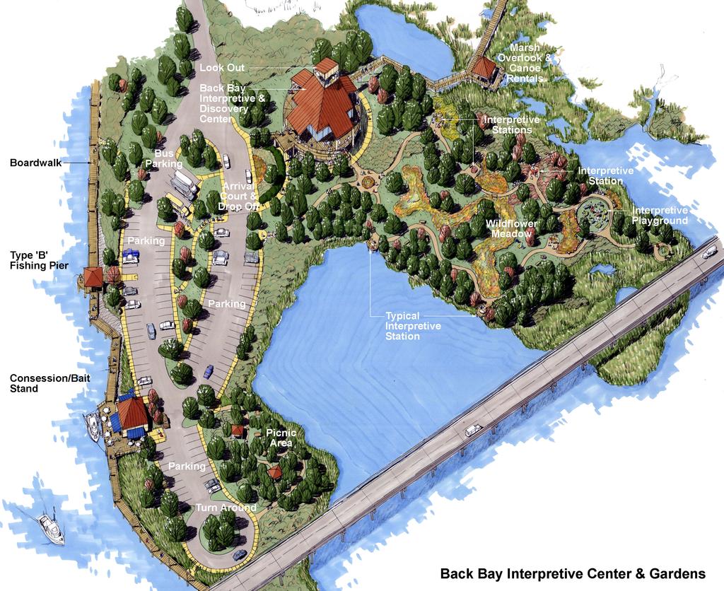
10 around the parking area toward the Back Bay side of the park so they would not be in conflict with the visitor s backing boats into the launch area. The proposed parking spaces are 10 by 45 pull through spaces to ease in maneuvering the turn to retrieve the boats. A new covered fishing pier and parking complex will be constructed in place of the previous dilapidated pier. This will mark the entrance to the second system of marsh boardwalks. The Back Bay Interpretive Center and Gardens makes up the final component of the park. An elliptical parking configuration was designed to complement the existing shape of the road, as well as offer enough spaces to accommodate the Interpretive Center, the proposed fishing piers and boardwalks, and the light commercial structure. The Interpretive Center itself should be approximately 5,000 square feet with the first floor elevation set at 15 feet. The ground level would be an open pavilion area where outdoor exhibits could occur.
11 The gardens associated with the Center would contain educational exhibits focusing on marsh development and the flora and fauna native to the area. Additionally, a Back Bay playground will be located among the exhibits. Typical garden exhibits depicted on the master plan are butterfly, humming bird, dragonfly, wildflower, speckled trout, redfish and other brackish water fish. The gardens encircle a wildflower meadow which ties them all together. The roadway terminates in a cul de sac with a radius large enough to accommodate buses and returns visitors to the picnic area it borders.
12
13 Work Previously Completed Work Item Demolition Clearing Grubbing & Water Edge Treatment (River Side) Boardwalk Development Asphalt Roadway Repair & Topping Parking Roadway Lighting Boat Launch Fishing Piers Marsh Boardwalk & Shelters Signage & Gate Utilities Description of Work Removal of pilings, concrete slabs, broken asphalt, concrete steps, etc. Selected clearing trees & shrubs, removal of dead trees, trash & debris, etc. Break up large concrete & asphalt slabs, top with uniformed limestone rip-rap from bridge to end of old piling south of existing boat launch 8 concrete walk, benches, trash receptacles, lighting, etc. between bridge & boat launch Repair &top existing asphalt roadway with 2 ½ wearing coarse from bridge to boat launch Parking at fishing piers 16 light 60 o.c. form bridge to boat launch Catwalk repair, parking & lighting 1-Type A wood fishing piers (without shelters) between bridge & boat launch 6 wood boardwalk over marsh area with 1 shelters (north end) 2-Directional signs at Causeway Bridge Road Electrical and Water services from bridge to boat launch Updated March 19, 2012 Updated March 26, 2013
14 Preliminary Construction Budget Phase I Work Item Description of Amount Work Demolition Removal of pilings, $50,000 concrete slabs, broken asphalt, concrete steps, etc. Clearing & Selected clearing trees $50,000 Grubbing & shrubs, removal of dead trees, trash & debris, etc. Water Edge Break up large $100,000 Treatment (River Side) concrete & asphalt slabs, top with uniformed limestone rip-rap from bridge to end of old piling south of existing boat launch Asphalt Repair &top existing $60,000 Roadway Repair & Topping asphalt roadway with 2 ½ wearing coarse from boat launch to south end of existing road New Asphalt Parking area at $6,000 Paving proposed North Marsh Boardwalk Parking Parking at fishing $9,000 piers Roadway & parking $40,000 from future Interpretive Center to picnic area, east side of existing roadway (includes turnaround) Concrete 4 concrete walkways $20,000 Walkways & Curbing & curbing at new parking areas Roadway 16 light $20,000 Lighting 60 o.c. from boat launch to turnaround Fishing Piers 2-Type A wood $34,000 Updated March 19, 2012 Updated March 26, 2013
15 Marsh Boardwalk & Shelters Picnic Area Signage & gate Landscaping & Marsh Restoration Utilities fishing piers (without shelters) between bridge & boat launch 1-Type B fishing pier $60,000 (with shelter & restrooms) 2 shelters on 6 wood $40,000 boardwalk over marsh area (north end) Site Preparation, $40,000 shelters, walkways, picnic tables, trash receptacles, etc. 1-Park Entry sign & $6,000 gate at bridge Directional graphics $3,000 General landscaping $40,000 to include trees, shrubs, seeding and marsh restoration planting Electrical and water $40,000 services from boat launch to turnaround and force main services for entire Causeway Subtotal $618,000 15% Contingency $92,700 Testing & Permitting $4,000 Total Estimated Phase I $714,700 Construction Budget Updated March 19, 2012 Updated March 26, 2013
16 Phase II Work Item Water Edge Treatment Boardwalk Development Asphalt Paving Concrete Walkways & Curbing Roadway Lighting Fishing Piers Bridge Cladding Landscape & Irrigation Description of Work Rework existing rip-rap edge, add uniform limestone rip-rap from first phase treatment to Causeway Bridge 8 concrete walk, benches, trash receptacles, lighting, etc. between boat launch & Phase II Type B fishing pier Asphalt roads & parking at Interpretive Center area 4 concrete walkways & curbing at new Interpretive Center parking areas Concrete walkway to peninsula fishing piers 16 light standards at new parking areas Bridge fishing pier and boardwalk (includes lighting, benches, wood curbing railing, etc.) 2-Type A fishing piers (without shelters) one between boat launch and turn around and two along peninsula 1-Type B fishing piers (with shelter & restroom Wood cladding of existing bridge guard rails Trees, shrubs & seeding Amount $60,000 $25,000 $88,000 $16,000 $9,000 $33,000 $50,000 $16,000 $60,000 $5,000 $50,000 Updated March 19, 2012 Updated March 26, 2013
17 Interpretive Center Park Development Improvements include site clearing & grubbing, grading & drainage, fences & gates, walkways, trash receptacles, benches, lighting, landscaping & irrigation, play area, drinking fountains, interpretive stations & graphics, restrooms, utilities, etc. $361,000 Subtotal $773,000 15% Contingency $115,950 Testing & Permitting $4,000 Total Estimated Phase II $892,950 Construction Budget Updated March 19, 2012 Updated March 26, 2013
18 Phase III Work Item Interpretive Center Building Description of Work Improvements include site preparation, arrival plaza, lower deck, second story exhibit area, upper deck, handicap ramp, look out tower, elevator, interior interpretive exhibits, furniture, fixtures & equipment, & south marsh boardwalks & shelters Amount $1,773,000 Subtotal $1,773,000 15% $265,950 Contingency Testing & $20,000 permitting Total Estimated Phase III Construction Budget $2,058,950 Phase IV Work Item Concession & Bait Stand Description of Work Improvements include site preparation, building, decking, F,F&E, utilities, etc. Amount $217,000 Subtotal $217,000 15% $32,550 Contingency Testing & $5,000 permitting Total Estimated Phase IV Construction Budget $254,550
19 Popps Ferry Causeway Cost Estimate updated March 2013 Phase of Work Previously City Funded Previous FEMA Funding Previous Tidelands Funding Proposed BP Funding Total Improvements Engineering/Design/Permitting $220,000 $420,000 $640,000 Removal of debris, obstructions, old pilings & old bulkheads $215,000 $215,000 Construction of the existing Boardwalk on the west side of the $390,000 $390,000 Causeway Re-Construction of the existing boardwalk on the west side of the Causeway due to Hurricane $150,000 $150,000 Katrina Construction of the proposed concrete promenade, fishing piers, and roadway repairs on the east $650,000 $650,000 side of the Causeway Back Bay Environmental Educational Center Phase I* $714,700 $714,700 Back Bay Environmental Educational Center Phase II* $892,950 $892,950 Back Bay Environmental Educational Center Phase III* $2,058,950 $2,058,950 Back Bay Environmental Educational Center Phase IV* $254,550 $254,550 Total $220,000 $150,000 $1,255,000 $4,341,150 $5,966,150 *As shown in the Cashio Cochran Master Plan
Project Location. Jay and Patty Baker Park and Gordon River Greenway Connector Bridge. Naples Beach Golf Club. Gordon River. East. Naples.
 Gordon River Project Location Naples Beach Golf Club East Naples Naples Naples Bay Evergreen Golf and Country Club and Gordon River Greenway Connector Bridge Gordon River Greenway CONNECTOR BRIDGE AND
MIAMI 21 PUBLIC HEARING-FIRST READING 2009
 General Principles Public access waterfront walkways shall: 1. Feel public. No one should feel as if he or she is intruding on private property. The public should feel welcome and at ease to move along
AS ADOPTED - JULY 2012
 TBLE OF CONTENTS General Principles Public access waterfront walkways shall: 5 Bulkheads or Seawalls 5 Natural Shorelines 6 Design Standards for Bulkheads or Seawalls 6 Design Standards for Waterfront
GYPSUM PARKWAY CORRIDOR ENHANCEMENT Gypsum, Colorado. Schematic Design January 2015
 GYPSUM PARKWAY CORRIDOR ENHANCEMENT Gypsum, Colorado Schematic Design January 2015 1 2 3 4 5 6 7 8 9 DESIGN WORKSHOP Landscape Architecture Land Planning Urban Design Tourism Planning Asheville Aspen Austin
STORMWATER MANAGEMENT FACILITIES/STORMWATER PONDS - What Are They?
 STORMWATER MANAGEMENT FACILITIES/STORMWATER PONDS - What Are They? As land is developed, the natural water cycle is disrupted. Rain infiltrates less, resulting in larger amounts of runoff This increased
PHASE 3-4 PARKS SOUTH PARK AND CHANNEL PARK
 PHASE 3-4 PARKS SOUTH PARK AND CHANNEL PARK Sheet List L1.0 L2.0 L3.0 L4.0 L5.0 L6.0 L7.0 L8.0 L9.0 L10.0 L11.0 L12.0 L13.0 L14.0 L15.0 L16.0 L17.0 L18.0 L19.0 L20.0 L21.0 L22.0 Cover Open Space Context
OPPORTUNITIES AND CONSTRAINTS - OXBOW PARK ENTRANCE AND PUT-IN
 OPPORTUNITIES AT OXBOW EXISTING WETLANDS Site is undeveloped and we can design a park that works well from the start. SAND BEACH Potential to eliminate invasive species. DEBRIS (CONCRETE, OLD CARS) VEGETATION
4.0 Concept Plan Implementation
 4.0 Concept Plan Implementation The following section defines the recommended strategy for the implementation of the Terwillegar Park Concept Plan including park management guidelines, capital costs, development
MASTER PLAN IMPLEMENTATION COSTS. Appendix A
 Appendix A MASTER PLAN IMPLEMENTATION COSTS Town of Bradford West Gwillimbury HENDERSON COMMUNITY PARK MASTER PLAN IMPLEMENTATION COSTS Draft Order of Magnitude Costing Revised 5/27/2014 ITEM DESCRIPTION
CITY AND COUNTY OF DENVER DEPARTMENT OF PUBLIC WORKS CONTRACT NO CONFLUENCE BIKE/PED RAMPS-SOUTH PLATTE GREENWAY STATEMENT OF QUANTITIES
 01050-1 Construction Surveying 1 LS 01500-1 Temporary Fences & Barricades 1,500 LF 02600-1 Shoring, Cofferdam, Temp. Sheeting, & Dewatering 1 LS 01565-1 Storm Drainage & Erosion Sediment Control 1 LS 01565-2
Preferred Riverwalk Alternative Components August 17, 2017:
 Preferred Riverwalk Alternative Components August 17, 2017: 1. Entrance and Future Pump Station Location: Entrance location to line up with main parking entrance to Captain Parkers and allows future Pump
1. Parks & Recreation Neighborhood Parks Community Parks Special Use Sites 2. Open Space 3. Trails
 Appendix A: Park Classifications The intent of parks and recreation classifications is to aid in making acquisition and design decisions for park sites, facilities and the organization of recreation space
Blue Springs Park. Park Land Established: Developed Acres: 12 acres Undeveloped Acres: 2 acres
 Blue Springs Park Park Location: 2204 SW South Ave. Park Land Established: 1975 Park Size: 14 acres Developed Acres: 12 acres Undeveloped Acres: 2 acres Park Type: Neighborhood Park Amenities: Softball
BEMIDJI CITY COUNCIL Work Session Agenda Monday July 9, 2012
 BEMIDJI CITY COUNCIL Work Session Agenda Monday July 9, 2012 City Hall Conference Room 5:30 p.m. 1. CALL TO ORDER / ROLL CALL 2. REVIEW PARK PLANS FOR PAUL BUNYAN PARK, LIBRARY PARK AND SOUTH SHORE BAUER
ANCHORAGE PARK REPORT CARD Assessing A Park s Appearance, Function, & Condition
 ANCHORAGE PARK REPORT CARD Assessing A Park s Appearance, Function, & Condition Park Name: Is Your Park an A or an F? Your Name: Contact Information Optional: Date: General Instructions: Phone: Email:
Rotary Park / Railroad Lake
 Rotary Park / Railroad Lake Park Location: 600 NW Vesper St. Park Land Established: 1975 Park Size: 12 acres Developed Acres: 12 acres Undeveloped Acres: 0 acres Park Type: Community Park Amenities: 2
Burrus Old Mill Park
 Burrus Old Mill Park Park Location: 112 NW Woods Chapel Rd. Park Land Established: 1969 Park Size: 14 acres Developed Acres: 14 acres Undeveloped Acres: 0 acres Park Type: Neighborhood Park Amenities:
JACKsON STREET PIER CONCEPTUAL DESIGN PACKAGE SEPTEMBER 21, 2017
 JACKsON STREET PIER CONCEPTUAL DESIGN PACKAGE SEPTEMBER 21, 2017 JACKsON STREET PIER Process outline DESIGN PROCESS OVERVIEW: Sandusky s Jackson Street Pier Conceptual Design process included input from
CECW-AG 11 June 1998 MEMORANDUM FOR MAJOR SUBORDINATE COMMANDS AND DISTRICT COMMANDS
 CECW-AG 11 June 1998 MEMORANDUM FOR MAJOR SUBORDINATE COMMANDS AND DISTRICT COMMANDS SUBJECT: Policy Guidance Letter No. 59, Recreation Development at Ecosystem Restoration Projects 1. References: a. ER
North Shore Trail. Council Meeting June 10, 2002
 North Shore Trail Council Meeting June 10, 2002 Process Guiding Principles Inventory and Analysis Preliminary Concepts (4) Final Concept Phasing Strategy Estimated Costs OVERVIEW Purpose: Prepare an overall
Summary of Changes in the DRAFT Rivers Project Natural Resource Master Plan from the 2001 approved plan to 2014 plan
 Summary of Changes in the DRAFT Rivers Project Natural Resource Master Plan from the 2001 approved plan to 2014 plan The entire Master Plan format and layout has been changed to comply with regulation
BRADENTON RIVERWALK EXPANSION MASTER PLAN
 BRADENTON RIVERWALK EXPANSION MASTER PLAN INTRODUCTION & AGENDA Process Update Community Engagement Summary Center for Active Design (CfAD) Recommendations Context and Existing Conditions Master Plan Alternatives
Main Street Conversion Site
 Main Street Conversion Site Borough of Brooklyn, New York Preliminary Presentation Park Expansion Design & Development Committee 13 September 2012 Michael Van Valkenburgh Associates, Inc. Landscape Architects,
PARTF Scoring System for Grants
 PARTF Scoring System for Grants The members of the N.C. Parks and Recreation Authority use the PARTF scoring system as one of several tools to select grant recipients. Please provide all of the information
Woods Chapel Park. Park Amenities: Playground, basketball court, single table shelter, small pond and multi-use trail.
 Woods Chapel Park Park Location: 3925 NW Dogwood Park Land Established: 1979 Park Size: 10 acres Developed Acres: 6 acres Undeveloped Acres: 4 acres Park Type: Neighborhood Park Amenities: Playground,
KASPER. City of Georgetown, Texas PUD Planned Unit Development. December 30, 2015 Revised January 27, 2016
 KASPER City of Georgetown, Texas PUD Planned Unit Development December 30, 2015 Revised January 27, 2016 Applicant: Sentinel Land Company, LLC 4910 Campus Drive Newport Beach, CA Prepared by: SEC Planning
29 Bella Fontaine Park
 29 Bella Fontaine Park 9565 Bellefontaine Road St. Louis County Parks Master Plan Planning Zone 2 Visit Date: July 2016 Page 1 129 Bella Fontaine Park 9565 Bellefontaine Road St. Louis County Parks Master
Highland Falls Waterfront Redevelopment Feasibility Study Village Board Meeting March 20, 2017
 Village Board Meeting March 20, 2017 Agenda I. Public Meeting #1 Visioning Summary II. Public Meeting #2 Comment Summary III. IV. IV. Case Study: Milton Train Station Schematic Design Concepts Schedule/Next
DATE ISSUED: March 12, 2014 REPORT NO: 101. Old Globe Way Improvements and San Diego Zoo Employee Parking Structure
 DATE ISSUED: REPORT NO: 101 ATTENTION: SUBJECT: Park and Recreation Board Agenda of March 20, 2014 Old Globe Way Improvements and San Diego Zoo Employee Parking Structure SUMMARY Issue Should the Park
Eastcreek Farm. Planned Development Standards September, 2014
 Eastcreek Farm Planned Development Standards September, 2014 ekfarm Contents 01. General Standards 02. Residential Development Standards 03. Architectural Design Standards 04. Landscape Design Standards
Preliminary Sketch Plan for Fort Hunter Park
 Preliminary Sketch Plan for Fort Hunter Park Public Presentation November 19, 2009 Dauphin County Parks and Recreation 100 Fort Hunter Road Harrisburg, PA 17110 (717) 599-5188 www.dauphinc.org THOMAS COMITTA
MetroParks Board Meeting 2018 Capital Improvement Projects
 MetroParks Board Meeting 2018 Capital Improvement Projects Stephen L. Avery Planning & Operations Director Last Edited: 3.12.18 Presentation Outline MetroParks Mission Statement Strategic Master Plan MetroParks
Minto-Brown Island. November 18, City of Salem, Parks & Transportation Services
 Minto-Brown Island Park Master Plan Public Meeting #1 November 18, 2014 City of Salem, Parks & Transportation Services Division, i i Public Works Welcome... and thanks for participating in the master planning
DRAFT SECTION 4(F) EVALUATION STILLWATER MUNICIPAL BARGE FACILITY
 EVALUATION STILLWATER MUNICIPAL BARGE FACILITY") DRAFT SECTION 4(F) EVALUATION I. DESCRIPTION OF SECTION 4(F) RESOURCE The Section 4(f) resource discussed in this evaluation is known as the Stillwater Municipal Barge Facility property, known previously
DRAFT SECTION 4(F) EVALUATION I. DESCRIPTION OF SECTION 4(F) RESOURCE The Section 4(f) resource discussed in this evaluation is known as the Stillwater Municipal Barge Facility property, known previously
ACADEMY AREA CONCEPT PLAN
 ACADEMY AREA Strip ling C hape l Roa d CONCEPT PLAN 7 S2 U Stripling 52 ROADWAYS AND PARKING: ADVENTURE PLAYGROUND AND SPRAYGROUND: Current roadways follow existing drives. It is recommended that the Folds
Bullhead City Rotary Park Plan Update
 Bullhead City Rotary Park Plan Update PLANNERS/LANDSCAPE ARCHITECTS: RBF Consulting 16605 N 28 th Avenue Suite 100 Phoenix, Arizona 85053-7550 (602) 467-2200 CIVIL ENGINEER: RBF Consulting 16605 N. 28
Wilbur Young Park. Park Land Established: Developed Acres: 15 acres Undeveloped Acres: 25 acres
 Wilbur Young Park Park Location: 1100 SE Adams Dairy Parkway Park Land Established: 1987 Park Size: 40 acres Developed Acres: 15 acres Undeveloped Acres: 25 acres Park Type: Community Park Amenities: Shelter
City of Kearney Capital Improvement Update October 1, TH STREET AND 17TH AVENUE IMPROVEMENTS
 56TH STREET AND 17TH AVENUE IMPROVEMENTS FUNDING: Bonded ESTIMATED COST: $3,885,000 COMPLETION DATE: Fall 2018 SCOPE OF PROJECT: Widening of 56th Street from 6th Avenue to 19th Avenue, and widening 17th
Clearwater Marina District Boardwalk Design Guidelines and Specifications
 General Information: The Clearwater Marina District Boardwalk Design Guidelines and Specifications, adopted by Ordinance No. 8438-13, should be considered a supplemental document to the City of Clearwater
ENVIRONMENTAL / OPEN SPACE
 INTRODUCTION OPEN SPACE RESPONSILBILITIES COMPREHENSIVE PARKS & RECREATION MASTER PLAN WATERFRONT PARK RESOURCED-BASED AND NEIGHBORHOODPARKS ACTIVITY-BASEDPARKS LANDSCAPING & VEGETATIONPROTECTION PROTECTING
Ward Park. Park Land Established: Developed Acres: 9 acres Undeveloped Acres: 4 acres
 Ward Park Park Location: 1000 SW 22 nd St Park Land Established: 1979-80 Park Size: 13 acres Developed Acres: 9 acres Undeveloped Acres: 4 acres Park Type: Neighborhood Park Amenities: 2 Shelters, tennis
Project purpose. advise. The purpose of the Beaumaris Lake Open Space Rehabilitation project is to: + Develop a Functional Program Concept
 Project purpose owns Road Beaumaris Road The purpose of the Beaumaris Lake Open Space Rehabilitation project is to: + Develop a Functional Program Concept + Guide Rehabilitation of Landscape and Community
Notice of Preparation (NOP) of an Environmental Impact Report and Public Scoping Meeting for the Alameda Shipways Residential Project
 of an Environmental Impact Report and Public Scoping Meeting for the Alameda Shipways Residential Project") Notice of Preparation (NOP) of an Environmental Impact Report and Public Scoping Meeting for the Notice is hereby given that the City of Alameda, Lead Agency, will prepare an Environmental Impact Report
Notice of Preparation (NOP) of an Environmental Impact Report and Public Scoping Meeting for the Notice is hereby given that the City of Alameda, Lead Agency, will prepare an Environmental Impact Report
VIRGINIA KEY CONSENSUS MASTER PLAN
 VIRGINIA KEY CONSENSUS MASTER PLAN JULY 2010 Existing Conditions JULY 2010 STAKEHOLDER INTERVIEW PROCESS, January 18-22, 2007 PUBLIC MEETING #1: SITE INVENTORY AND ANALYSIS, March 29, 2007 PUBLIC MEETING
January 11, New benches installed. Paving of parking lot adjacent to piers and the canoe put-in. Near complete with clean up remaining.
 Project Updates January 11, 2018 CENTERVILLE CHESAPEAKE ARBORETUM BELLS MILL CITY CREEKWOOD SOUTH DEEP CREEK LOCK WORK TO BE PERFORMED/UPDATES Improvements to the parking lot include installation of a
ATTACHMENT A BUCKLEY COVE BOAT LAUNCH AND PARKING, PARK A. BUCKLEY COVE BOAT LAUNCH AND PARKING B. BUCKLEY COVE PARK
 BUCKLEY COVE BOAT LAUNCH AND PARKING, PARK A. BUCKLEY COVE BOAT LAUNCH AND PARKING B. BUCKLEY COVE PARK BUCKLEY COVE PARK maintenance includes all area of park, including roadways and to the water s edge.
Emerson Park Master Plan Update. Public Meeting III August 27, 2014
 Emerson Park Master Plan Update Public Meeting III August 27, 2014 Meeting Agenda: Project Update Presentation of Master Plan Components Discussion and Feedback The Path Forward: Building on the Concept
russell+mills studios
 S C H E M A T I C D E S I G N B O O K L E T O C T O B E R 2 2, 2 0 0 8 114 east oak st, fort col TABLE OF CONTENTS...ii SITE CONTEXT...1 BACKGROUND...2 PARK PROGRAM...3 SLOPE ANALYSIS...4 SPATIAL ANALYSIS...5
Y Sports Complex PROGRAMMING Capitol Improvement Plan. Anticipated/Suggested Improvements. Sedgwick County Park: Sports Complex:
 PROJECT OVERVIEW Location: East of Ridge Road, between 21 st Street and 13 th Street, not including SCZ In conjunction with The Sedgwick County Park Facilities Observation Report Compilation of improvements
SALEM FOREST RIVER PARK PRELIMINARY POOL AREA ASSESSMENT & MASTER PLAN STUDY. For the City of Salem
 SALEM PRELIMINARY POOL AREA ASSESSMENT & MASTER PLAN STUDY For the City of Salem 6-13-17 This process undertaken by Weston & Sampson is to outline preliminary ideas only of what possibilities exist for
2007 Blaine Wharf District Master Plan ii
 INTRODUCTION... 1 BLAINE SETTING... 1 GENERAL LOCATION... 2 WHARF DISTRICT... 2 SITE HISTORY... 5 PLANNING AND ANALYSIS PROCESS... 5 BLAINE WHARF DISTRICT MASTER PLAN... 7 CITY OF BLAINE VISION STATEMENT
Philip A. Ginsburg, General Manager Toks Ajike, Acting Planning and Capital Program Director
 Date: March 7, 2018 To: Through: From: Subject: Recreation and Park Commission Capital Committee Philip A. Ginsburg, General Manager Toks Ajike, Acting Planning and Capital Program Director Dan Mauer,
City of San Juan Capistrano PROJECT PRESENTATION NORTHWEST OPEN SPACE COMMUNITY PARK (CIP 09209) March 22, 2016 FOR THE PROJECT PRESENTATION
 March 22, 2016 FOR THE PROJECT PRESENTATION") City of San Juan Capistrano PROJECT PRESENTATION PROJECT PRESENTATION FOR THE NORTHWEST OPEN SPACE COMMUNITY PARK (CIP 09209) PLANNING COMMISSION 1 PROCESS & OBJECTIVES A. Develop a new Concept Plan for
City of San Juan Capistrano PROJECT PRESENTATION PROJECT PRESENTATION FOR THE NORTHWEST OPEN SPACE COMMUNITY PARK (CIP 09209) PLANNING COMMISSION 1 PROCESS & OBJECTIVES A. Develop a new Concept Plan for
County of El Dorado Standard Plans
 County of El Dorado Standard Plans Table of Contents Section 1 General Standards GS-01 General Legend and Abbreviations Section 2 Roads and Streets RS-01 RS-02 RS-03 RS-04 RS-05 RS-06 RS-07 RS-08 RS-20
PRELIMINARY DESIGN + DEVELOPMENT PLAN
 WELCOME! To The Public Open House May 30 th, 2017 HARBOUR WEST PARKS Vision Project Overview The City s vision for Port Credit Harbour West Parks is to develop a vibrant waterfront destination that integrates
SOUTH PARK. Construction of a Portion of South Park at Fresh Kills Park, Staten Island
 SOUTH PARK Construction of a Portion of South Park at Fresh Kills Park, Staten Island FRESHKILLS PARK FIRST PHASE OF SOUTH PARK FRESHKILLS PARK CONTEXT SOUTH PARK EXISTING CONDITIONS PROJECT OPPORTUNITIES
Goat Island Masterplan
 Goat Island Masterplan City of Georgetown Georgetown, South Carolina December 4, 2013 City Council: Mr. Jack Scoville, Mayor Ms. Peggy Wayne, Mayor Pro-Tempore Mr. Brendon Barber, Sr. Mr. Clarence Smalls
Ohlone College Measure G Project Scope Revisions
 Scope Revisions Current Title Revised Title Current Scope Revised Scope 6101 Relocated Baseball Field Athletic Fields Create new sustainable baseball field with synthetic turf, bleacher seating and batting
Recreation Facility Evaluation - Conclusions
 2015 Parks Report Upon initial assessment of the Village parks it was evident that the inventory of the Village s park land, athletic fields, recreational facilities, playgrounds, trails, etc., was substantial,
Storm Water Quality and Shoreline Restoration Improvements - Grant Funding Request City of Mound Carlson Park Bolton & Menk Project No.
 September 15, 2016 Brett Eidem Cost Share Grant Administrator Minnehaha Creek Watershed District 15320 Minnetonka Boulevard Minnetonka, MN 55345 RE: Storm Water Quality and Shoreline Restoration Improvements
PROJECT SITE The Proposed Project includes the Allen and Pike Street malls between Delancey and South Streets (see Figure 2C-1).
.") Chapter 2, Section C: A. INTRODUCTION This chapter considers the potential of the proposed Reconstruction of the Allen and Pike Street Malls project to affect the urban design characteristics and visual
Chapter 2, Section C: A. INTRODUCTION This chapter considers the potential of the proposed Reconstruction of the Allen and Pike Street Malls project to affect the urban design characteristics and visual
ADOPTED CAPITAL IMPROVEMENT PROGRAM BUDGET ARROYO PROJECTS
 ADOPTED CAPITAL IMPROVEMENT PROGRAM BUDGET ARROYO PROJECTS HAHAMONGNA FY 212-216 Capital Improvement Program Priority Description Total Estimated Costs Appropriated Through FY 211 Adopted FY 212 FY 213
South East Sports Complex Phase I
 South East Sports Complex Phase I City of Spokane Design Review Board August 29, 2018 (Revised) Objectives 1. Early discussion and collaboration. 2. Provide framework / catalyst for future improvements
Outdoor Recreation Plan
 City of Bayfield Bayfield, Wisconsin 54814 Outdoor Recreation Plan Approved by the City of Bayfield Parks & Recreation Committee - 2015 P.O. Box 1170 Bayfield, WI 54814 715-779-5712 www.cityofbayfield.com
Exhibit A: Project Scope
 Exhibit A: Project Scope The Project Scope includes: A brief description of the work product and estimated cost to complete the work product by location at each of the 12 sites. A brief description of
Chapter 4: Jordan Road Character District
 4: Jordan Road Character District 4.1 Introduction The Jordan Road character district encompasses much of the former Jordan orchard and farmstead, which was a significant part of Sedona s history. The
DISCUSSION TOPIC: ST JOHNS RIVER & ITS TRIBUTARIES (BPII) 2030 COMPREHENSIVE PLAN POLICES AND REGULATORY FRAMEWORK
 2030 COMPREHENSIVE PLAN POLICES AND REGULATORY FRAMEWORK") DISCUSSION TOPIC: ST JOHNS RIVER & ITS TRIBUTARIES (BPII) 2030 COMPREHENSIVE PLAN POLICES AND REGULATORY FRAMEWORK St. John s River & Its Tributaries Issue Summary: The St. Johns River is an important
DISCUSSION TOPIC: ST JOHNS RIVER & ITS TRIBUTARIES (BPII) 2030 COMPREHENSIVE PLAN POLICES AND REGULATORY FRAMEWORK St. John s River & Its Tributaries Issue Summary: The St. Johns River is an important
Reconnecting to a Forgotten River St. Cloud MN. Aaron Hanson Design Design Thesis LA 572, Thesis, Spring 2012
 Reconnecting to a Forgotten River St. Cloud MN Aaron Hanson Design Design Thesis LA 572, Thesis, Spring 2012 site context 2.5 Miles Sartell St. Cloud to Fargo 170 Miles (2 hrs 45 mins) Hwy 10 infrastructure
Northern Branch Corridor SDEIS March 2017
 Northern Branch Corridor SDEIS March 2017 15. 15.1. Chapter Overview 15.1.1. Introduction This chapter discusses changes to the Preferred Alternative resulting in the potential for project improvements
FLORIN ROAD CORRIDOR Site Plan and Design Review Guidelines Checklist
 FLORIN ROAD CORRIDOR Site Plan and Design Review Guidelines Checklist Applicant s Name: Project Address: Phone: Email: Applicant shall fill out the design guidelines checklist for all guidelines applicable
VEHICULAR AND PEDESTRIAN CIRCULATION
 This perspective sketch communicates the intended character and quality of a proposed streetscape design. Locate benches near a major intersection where people tend to gather. Seating and lighting provide
M i s s i o n B a y W a t e r f r o n t
 114 M i s s i o n B a y W a t e r f r o n t Character of the Area: The Mission Bay Waterfront extends from Pier 48 at China Basin Channel to 18th Street in the Central Basin. This area of the waterfront
Long Branch-Wayne Local Park Renovation Project
 Montgomery Parks Long Branch-Wayne Local Park Renovation Project Community Meeting #2 September 20, 2016 Oak View Elementary School 7:00-9:00 PM Welcome / Team Introductions M-NCPPC (Montgomery Parks)
Washington Plaza at the. Lake Anne Village Center
 Lake Anne Village Center Washington Plaza Design Charrette Washington Plaza at the Lake Anne Village Center Process and Recommendations Presentation to the Reston Association Board of Directors January
Las Colonias Park Master Plan
 2013 Las Colonias Park Master Plan City of Grand Junction June 2013 Introduction Las Colonias Park, a 101 acre parcel on the edge of the Colorado River south of downtown, was deeded to the City of Grand
To qualify for federal Transportation Enhancement (TE) funds a project must meet two basic federal requirements:
 funds a project must meet two basic federal requirements:") Eligibility Requirements To qualify for federal Transportation Enhancement (TE) funds a project must meet two basic federal requirements: 1) Relate to surface transportation and 2) Be one of the 12 designated
Eligibility Requirements To qualify for federal Transportation Enhancement (TE) funds a project must meet two basic federal requirements: 1) Relate to surface transportation and 2) Be one of the 12 designated
Building and Site Design Standards
 Commercial Design Standards All Business and Industrial Uses as Described in Section 2234 Requiring Special Permit Review Except Large-Scale Ground Mounted Solar Photovoltaic Installations and Wireless
HURON WATERFRONT DEVELOPMENT AND AMPHITHEATER
 AWARD WINNING PROJECT Location Huron, Ohio Architectural, Engineering, Site, Landscaping, Planning, Survey, Grant Administration, Construction Administration Cost $285,000 Amphitheater $300,000 Marina
North Oakville East Parks Facilities Distribution Plan. November, 2009
 North Oakville East November, 2009 POLICY CONTEXT 1) Purpose a) The purpose of this document is to be a guide for the location, configuration, design and development of the parks system for the North Oakville
1999 Approval to replace World War I monument and relocate plaques Approval to rehabilitate the Chase Mill building and surrounding site
 Memorandum PLANNING DIVISION DEPARTMENT OF COMMUNITY AND NEIGHBORHOODS To: Historic Landmark Commission From: Katia Pace, Principal Planner Date: October 26, 2016 Re: Liberty Park Improvements The purpose
F. Driveways. Driveways which provide access to off-street parking or loading from public streets shall comply with the following:
 Section 20.945.040 General Design Standards for Surface Parking Areas. A. Review Authority. Parking lot design and drainage shall be subject to review and approval of the City Transportation Manager. B.
Buffalo, Iowa. Facilitators: Scott Freres, The Lakota Group Daniel Grove, The Lakota Group
 Buffalo, Iowa Facilitators: Scott Freres, The Lakota Group Daniel Grove, The Lakota Group Student Presenters: Myles Alexander, University of Illinois Jessica Morton, Western Illinois University Buffalo
BURTON STATION STRATEGIC GROWTH AREA PLAN UPDATE PUBLIC MEETING 3/26/18
 BURTON STATION STRATEGIC GROWTH AREA PLAN UPDATE PUBLIC MEETING 3/26/18 1 WHERE WE ARE? 2 PRIMARY OBJECTIVES OF THE PLAN UPDATE 1. Update the land use designation for Burton Station Village to reflect
ROME WATERFRONT VILLAGE PROJECT NARRATIVE January 25, 2018
 January 25, 2018 The Rome Waterfront Village project is intended to foster the revitalization of the area between South James Street and Erie Boulevard north of the Erie Canal as well as improve public
ARROYO PROJECTS ADOPTED CAPITAL IMPROVEMENT PROGRAM BUDGET
 A RROYO P ROJECTS ADOPTED CAPITAL IMPROVEMENT PROGRAM BUDGET FISCAL YEARS 214-218 HAHAMONGNA Priority Description 1 Hahamongna Watershed Park - Implement Master Plan 211,6 211,6 (77565) 2 Hahamongna -
DRAFT. CITY OF ESCONDIDO 11th Avenue Park WORKSHOP SUMMARY December 17, 2008
 DRAFT RJM DESIGN GROUP, INC. CITY OF ESCONDIDO 11th Avenue Park WORKSHOP SUMMARY December 17, 2008 INTRODUCTION This report summarizes the results of the planning process that was conducted as a part of
A 2012 Clean and Safe Neighborhood Parks Bond Project. Katy Tang, District Supervisor. Jasmine Kaw, Landscape Architect Will Kwan, Architect
 West Sunset Park A 2012 Clean and Safe Neighborhood Parks Bond Project Community Meeting #2 November 20, 2013 Katy Tang, District Supervisor Dan Mauer, Project Manager Jasmine Kaw, Landscape Architect
Chapter 6. Overall Vision RECOMMENDATIONS. More Trail and Trail. Connections. Equal Access to Park. Facilities and Programs. Water Access.
 Overall Vision More Trail and Trail Connections Equal Access to Park Facilities and Programs Water Access Environment Variety Chapter 6 RECOMMENDATIONS Chapter 6 The following recommendations for park,
Littleton Fields Master Plan
 Town of Littleton Littleton Fields Master Plan September 25, 2017 Gale Associates, Inc. John M. Perry, P.E. Jeffrey F. Georges, MRLA About Gale Agenda Introduction and Purpose Background Investigation
Open Space and Recreational Facilities
 Chapter 5: Open Space and Recreational Facilities A. INTRODUCTION According to the guidelines of the 2001 New York City Environmental Quality Review (CEQR) Technical Manual, an open space analysis is necessary
The open space system should provide connective elements, relate to natural resources, and enhance the suburban character of the landscape..
 The open space system should provide connective elements, relate to natural resources, and enhance the suburban character of the landscape.. Mixed-use and infill development should maintain or enhance
Hidden Pointe Landscape Master Plan. June, archi terra
 Hidden Pointe Landscape Master Plan June, 2006 t h e archi terra g r o u p 1 Table of Contents Background Purpose and Goals of the Master Plan Master Plan Process Existing Conditions Entrance Hidden Pointe
(Exhibit A) Site Plan Adoption Detail and Support Information
 Site Plan Adoption Detail and Support Information") McCormick Park Master Site Plan (Exhibit A) Site Plan Adoption Detail and Support Information July, 2003 McCormick Park Site Plans.... 2-3 McCormick Park Site Plan Comparison... 4 Basic Assumptions about
McCormick Park Master Site Plan (Exhibit A) Site Plan Adoption Detail and Support Information July, 2003 McCormick Park Site Plans.... 2-3 McCormick Park Site Plan Comparison... 4 Basic Assumptions about
PRE-DESIGN CONCEPT REPORT GRAND CANAL RESTORATION
 PRE-DESIGN CONCEPT REPORT GRAND CANAL RESTORATION Project Background November 19, 2007 Executive Summary The Grand Canal is an important tidal waterway in the Venice community of Los Angeles, California,
B L A C K D I A M O N D D E S I G N G U I D E L I N E S for Multi-family Development
 B L A C K D I A M O N D D E S I G N G U I D E L I N E S for Multi-family Development Adopted June 18, 2009 This section of the Design and focuses on site planning and design guidance for new multi-family
Play areas overlooking climbing hill. School & playgrounds overlooking pond bottom ballfields. Project experience while at Loris and Associates, Inc.
 City of Thornton Parks & Open Space Cherrywood Park Thornton, CO Architect: Design Concepts Construction of this seven-acre City park, located adjacent to Adams Twelve Five Star Prairie Hills Elementary
Summary Report. 15 Dec The Lynch Park Master Plan, Beverly, MA. Tappé Associates, Inc. Geller Associates, Inc.
 The Committee Lynch Park Advisory Committee Master Plan Presentation December 15, 2003 Agenda Introductions The Committee Purpose Process The Plan The Committee History of the Committee Who We Are City
COMMUNITY DESIGN. GOAL: Create livable and attractive communities. Intent
 COMMUNITY DESIGN Intent An attractive, well-designed County will attract quality development, instill civic pride, improve the visual character of the community, and create a strong, positive image for
Port of Camas-Washougal Waterfront Trail Master Plan
 Port of Camas-Washougal Waterfront Trail Master Plan The Port s facilities are the products of its mission: To make strategic investments that enhance the community s quality of life by bringing jobs,
A cknovvledgements. Table of Contents. Project Introduction...1
 Pashek Asscx::iates MARCH2007 A cknovvledgements Pashek Associates would like to thank Jackson Township and the Jackson Township Recreation Board for their valuable contributions, support, and input during