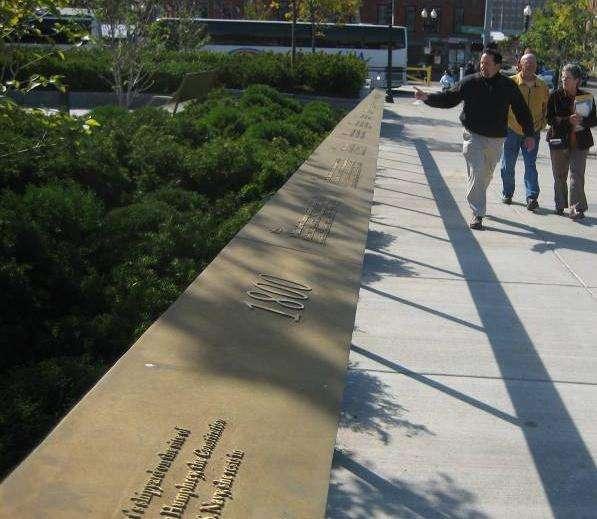
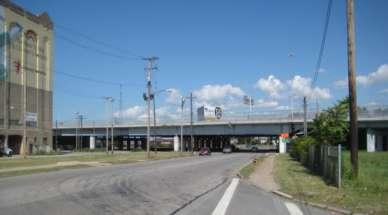
Cleveland Innerbelt Bridge / Central Viaduct City Planning Commission November 6, 2009
|
|
|
- Harry Owens
- 6 years ago
- Views:
Transcription
1 Cleveland Innerbelt Bridge / Central Viaduct City Planning Commission November 6, 2009
2 Process for Aesthetics Subcommittee June 25, 2009 Kick off Meeting June 26, 2009 Gateway and Tremont Focus Groups July 17, 2009 Cleveland City Planning Commission July 23, 2009 Initial Concepts July 24, 2009 Gateway and Tremont Focus Groups August 13, 2009 Refined Concepts August 14, 2009 Gateway and Tremont Focus Groups September 17, 2009 Final Concepts September 18, 2009 Gateway and Tremont Focus Groups October 2, 2009 Cleveland City Planning Commission October 22, 2009 Final Products Nov 5, 2009 Design Review Committee Nov 6, 2009 Cleveland City Planning Commission
3 Project Proposal Update - Schedule Final Design Build Package - December 1, 2009 Request for Qualification - February 2, 2010 Short Listing - March 23, 2010 Technical Proposals Due - August 3, 2010 Contract Award - September 17, 2010 Notice to Proceed - November 1, 2010 Post-Award Public Involvement Winter/Spring 2011
4 Agenda Project Updates Sustainability Initiatives Aesthetic and Enhancement Plans


5 Project Updates Vandal Protection Fence will not be required. TxDOT Barrier 32 concrete parapet with single elliptical pipe rail.

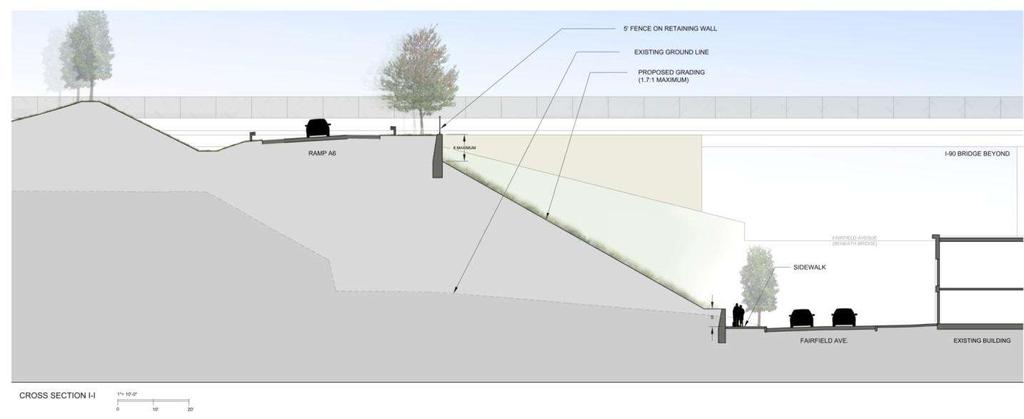
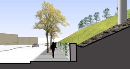
6 Vegetative Screening in Lieu of Noise Barrier Meeting with Tremont West and Community Groups 4pm Nov 20


7 Abbey Avenue Enhancements Abbey Bridge re-configuration will be constructed as an enhancement. Bike Lanes Striped between W. 11th and W. 20th On-street parking added to north side of Abbey (W. 11th to Bridge)


8 Abbey Avenue Enhancements (cont.) Potential Bridge Aesthetic Treatments - Barriers & Fence

9 Parking Along Abbey Ave.
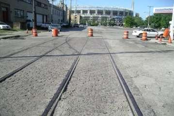
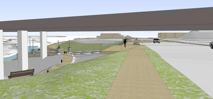
10 Towpath Trail Coordination West slope regrading includes bench for Towpath Trail Additional slope regrading proposed for CCG2 Bridge construction includes completion of the Towpath Trail ODOT will coordinate with Towpath Partnership for CCG2 construction
11 SUSTAINABILITY
12 Sustainability Plan Multi-Modal Accommodate future Towpath Trail in West Slope Multi-use path along proposed East Ninth Street and Ontario Street Addition of bicycle lanes on Abbey Avenue from W. 13 th St. to west end of Abbey Ave. Bridge 3 GCRTA Park and Ride Lot expansions Freeway Management System

13 Sustainability Plan Stormwater Reduced runoff to combined sewer systems. Stormwater management practices in full compliance with ODOT and Ohio EPA. DBT to construct detention-based BMP s Permeable pavement on Fairfield Ave tree lawn.

14 Sustainability Plan Cuyahoga River Incorporation of green bulkheads design (i.e., habitat pockets) along the Cuyahoga River for improved fish habitat Use of "ring chamber" pipes to aerate water headed to the river


15 Sustainability Plan - Materials Reuse of Medina block pavers on Central Viaduct Way Salvage Old Central Viaduct pier masonry for future Towpath Trail enhancements
16 Sustainability Plan Structures Durability Minimize bridge expansion joints Sealing concrete surfaces Emphasis in integrated design of structure drainage for minimal maintenance and long-term durability.

17 Sustainability Plan Energy Conservation Sustainable approach to be taken for bridge lighting, including prominent incorporation of LEDs Elimination of external lighting on overhead highway signs. Use of LED signal heads


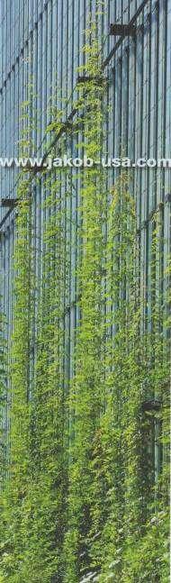
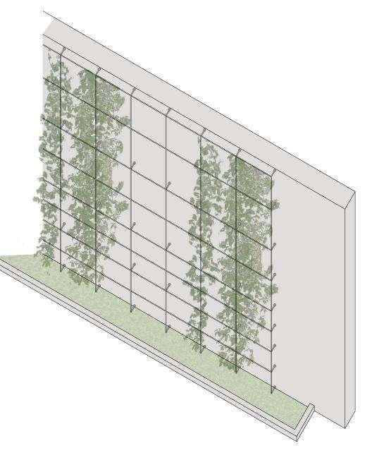
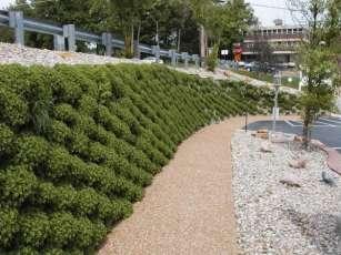
18 Sustainability Plan Urban Landscape Median and tree lawn landscaping Green walls on Fairfield Avenue Green screen on retaining walls by Tri-C, Hilton Meadow grasses in west slope excavation area replace existing impervious surfaces Use of native landscaping materials
19 Sustainability Plan Design Build Team Requirements Demonstrate Responsible Approach to: Minimizing Energy Usage Maximizing Long-Term Durability on Structures Construction Materials and Debris Earthwork Erosion and Sedimentation Control
20 How will the aesthetic recommendations be incorporated into the design / build process?

21 Superstructure Shape and Appearance Proposed Specification: Main Span Portion of the I-90 Viaduct Shall Consist of Haunched Girders Reflects Design Principle: New bridge should be consistent with shape of existing bridges yet not imitative.
22 Form, Rhythm and Continuity Proposed Specifications: Abrupt girder depth changes only at end piers of main viaduct. Consistent material type (steel or concrete) and superstructure shape (I-girder or box) for entire length of bridge. Reflects Design Principle: Design should be consistent and coherent across entire valley, and speak with single design vocabulary
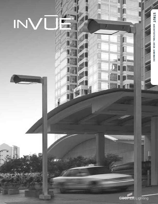
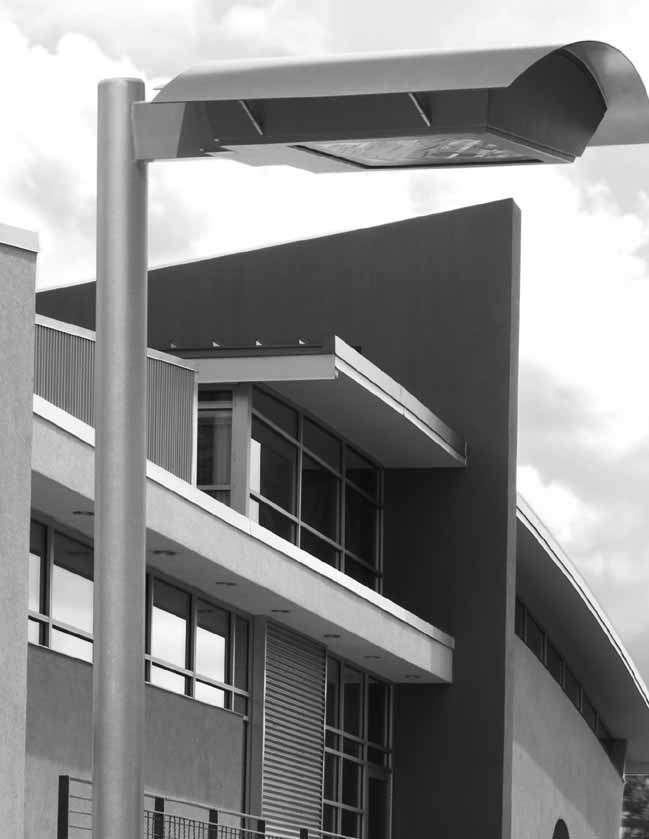
23 Architectural Lighting Proposed Specifications: An architectural lighting scheme will be designed for the new viaduct bridge. Plan shall be comparable to the lighting of the other downtown Cleveland bridges. Sustainable lighting plan requirements include LED fixtures Reflects Design Principle: Design should incorporate opportunities for aesthetic lighting in keeping with the lighting schemes common to existing bridges in the valley
24 Attention to Detailed Aesthetics Proposed Specifications: No stiffeners on the outside of the fascia girders. No horizontal drainage pipes below the bottom plane of the superstructure. Drainage systems required to match color of adjacent concrete/steel bridge elements. Reflects Design Principle: Treat side, under and above deck views with comparable effort to global views
25 Pier Configurations Proposed Specification: Single box superstructures single stem columns Twin box superstructures twin columns in line with box girders Multiple girder superstructures no more than two columns Reflects Design Principles:..placement of bridge supports should be conducive to positive and beneficial future land use adjacent to underside Consideration of people environment adjacent to and under bridge is important
26 Pier Shape Proposed Specification Rectilinear cross-section, reflective of adjacent high level bridges, with vertical articulation. Curved transition between top of pier caps and base of columns Reflects Design Principle: New bridge should be consistent with shape of existing bridges yet not imitative.
27 Streetscapes and Landscapes Proposed Specifications: In this case, the Request for Proposal (instructions to bidders) will include prescriptive drawings requiring design elements being discussed for Gateway and Tremont areas Reflects Design Principle: The design should be sensitive to the scale and appearance of the neighborhoods where it touches down and should respect the special character of Tremont and Gateway
28 Post-Award Public Involvement Design Build Team will prepare concepts for consideration at two stakeholder meetings and one public meeting. Stakeholder Meeting 1 Public Meeting Stakeholder Meeting 2 City Design Review and Planning Commission Final Approval
29 Post-Award Public Involvement (cont.) Viaduct Bridge (Main Spans and Approach Spans) Three (3) fully-integrated concepts illustrating: Color Finished surface treatment (reveals, chamfers, texture etc.) Pier shapes Architectural lighting
30 Post-Award Public Involvement (cont.) Other New Structures (Mainline over Ontario, Fairfield etc.) Three (3) fully-integrated concepts Color, Finished Surfaces, Pier Details where appropriate Grouped by Location Additional specifications require consistency and coordination with prescribed elements in neighborhoods.
 Retaining Walls (for those not already prescribed): Three integrated schemes showing color and surface treatments Broadway Mills Historic Commemorative")
31 Post-Award Public Involvement (cont.) Retaining Walls (for those not already prescribed): Three integrated schemes showing color and surface treatments Broadway Mills Historic Commemorative Display Three options using salvaged materials (medallions, brick work etc). Written history of the building s significance
32
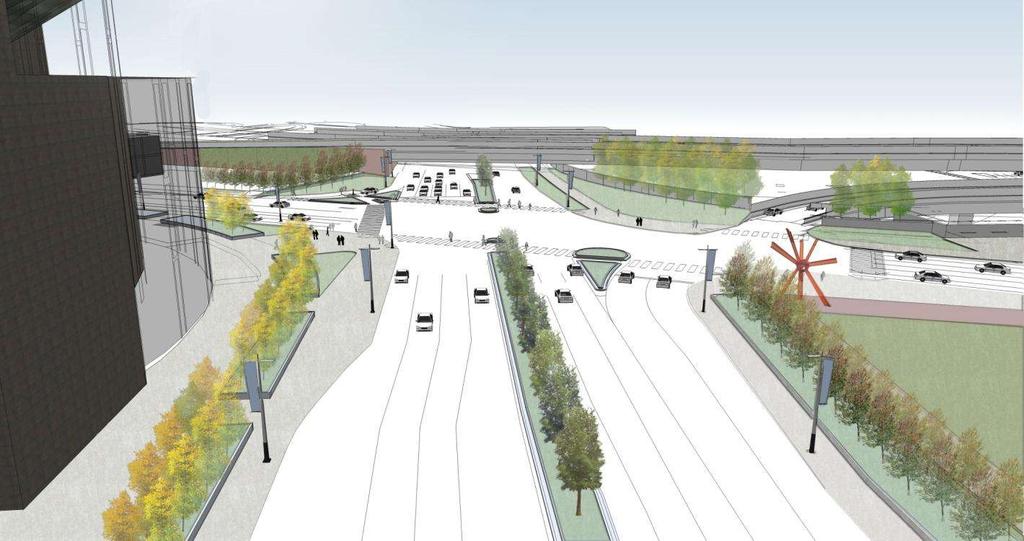
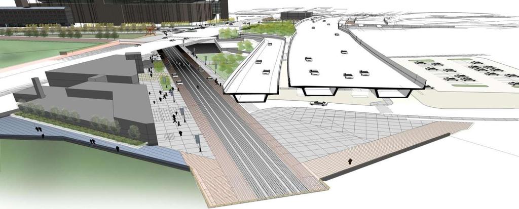
33 Gateway and Tremont Enhancement Areas

34 Gateway Overall Plan

35 Gateway Overall Plan (cont.)
36

37
38
39
40
41
42
43

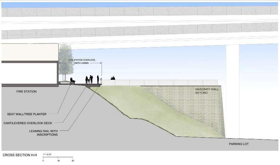
44 E 9 th St. Ramp Wall Elevation E 14 th St. Ramp Wall Elevation
45
46 Tremont Overall Plan
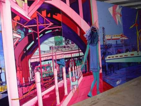
47
48
49 Wayfinding at Abbey Offramp

50 Abbey Ramp Wayfinding Wall

51 Abbey / West 14 th Loop Ramp
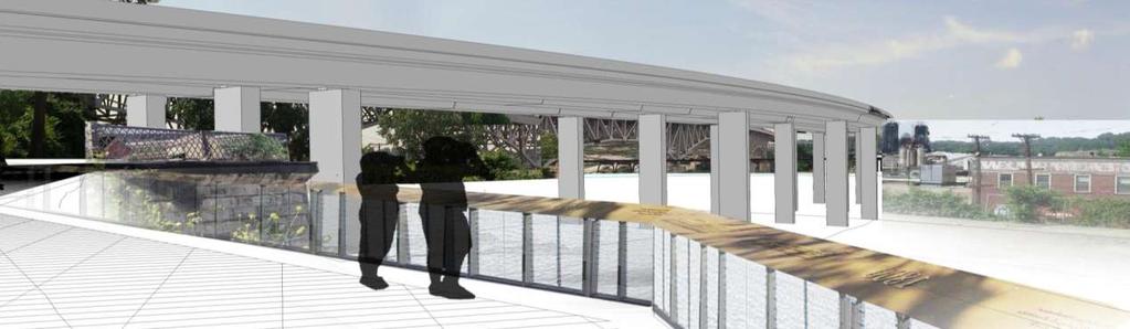
52 Viaduct Bridge Abutment - W 14 th St.
53 Viaduct Bridge Abutment - W 14 th St.
54
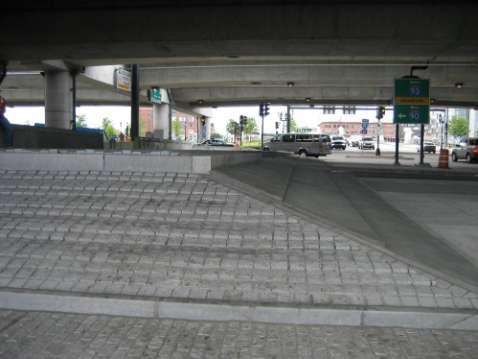
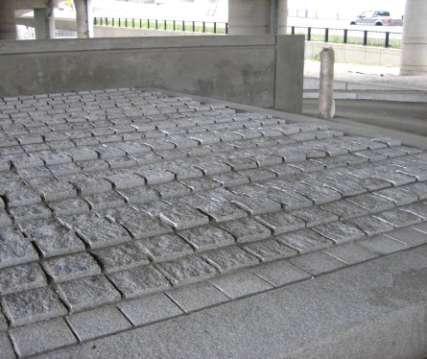
55 Underbridge surface materials W. 14 th St.
56
57 Thank you
Cleveland Innerbelt Bridge / Central Viaduct Cleveland City Planning Commission October 2, 2009
 Cleveland Innerbelt Bridge / Central Viaduct Cleveland City Planning Commission October 2, 2009 New Westbound Bridge Schedule December 1, 2009 Contract Documents/Plan Package March 1, 2010 Request for
INNERBELT BRIDGE PUBLIC MEETING #2
 Welcome to the INNERBELT BRIDGE PUBLIC MEETING #2 Today s Discussion Welcome and Introductions (Bob Brown, City of Cleveland) Innerbelt Project Status (Craig Hebebrand, ODOT) Bridge Type Selection Update
I-70/71 Innerbelt Project
 I-70/71 Innerbelt Project Project Progress Meeting and Design Enhancement Update November 9, 2009 Ohio Department of Transportation MS Consultants MSI Design Overview of Presentation 1. Recap Recent Project
Maplewood Avenue Downtown Complete Street Project
 Maplewood Avenue Downtown Complete Street Project Second Public Meeting January 24, 2018 Welcome and Introduction of Project Team City Planning and Public Works Staff City of Portsmouth Juliet Walker Planning
ROME WATERFRONT VILLAGE PROJECT NARRATIVE January 25, 2018
 January 25, 2018 The Rome Waterfront Village project is intended to foster the revitalization of the area between South James Street and Erie Boulevard north of the Erie Canal as well as improve public
Final Design Meeting. September 25, Creating Bridges As Art. Welcome & Introductions. Terry Ward - Project Manager
 Final Design Meeting September 25, 2014 Creating Bridges As Art 1 Welcome & Introductions Terry Ward - Project Manager 2 VQRC Final Design Meetings Meeting Date Items for Discussion Final Design Meeting
July 12, Columbus City Council City Hall 90 West Broad Street Columbus, OH RE: I-70/71 Columbus Crossroads Project
 OHIO DEPARTMENT OF TRANSPORTATION DISTRICT 6 400 EAST WILLIAM STREET DELAWARE, OHIO 43015 800.372.7714 Columbus City Council City Hall 90 West Broad Street Columbus, OH 43215-9015 RE: I-70/71 Columbus
VEHICULAR AND PEDESTRIAN CIRCULATION
 This perspective sketch communicates the intended character and quality of a proposed streetscape design. Locate benches near a major intersection where people tend to gather. Seating and lighting provide
Victoria Bridge Municipal Class EA Civic Works Committee
 Municipal Class EA John Pucchio, P. Eng., Project Manager June 19 2018 Introduction Existing Conditions Municipal Class EA Proposed Bridge Proposed Road Reconstruction Proposed Improvements Construction
Project Status. Construction is underway for Phase 3. Overall Project Area and Schedule. Schedule of Current Construction Phases.
 I-95 Avenue Interchange Project Status Construction is underway for Phase 3. Overall Project Area and Schedule Phase 0: Completed 2010 Section GR0: Completed in Fallin 2010 Phase 2: Completed Section GR2:
COMPLETE GREEN STREET CHECKLIST
 COMPLETE GREEN STREET CHECKLIST This document was developed to dissect the structure of an urban street and explore opportunities to make our streets more complete while also integrating green street strategies.
CITY AND COUNTY OF DENVER DEPARTMENT OF PUBLIC WORKS CONTRACT NO CONFLUENCE BIKE/PED RAMPS-SOUTH PLATTE GREENWAY STATEMENT OF QUANTITIES
 01050-1 Construction Surveying 1 LS 01500-1 Temporary Fences & Barricades 1,500 LF 02600-1 Shoring, Cofferdam, Temp. Sheeting, & Dewatering 1 LS 01565-1 Storm Drainage & Erosion Sediment Control 1 LS 01565-2
Downtown Cleveland Alliance/Tremont
 Cleveland Innerbelt Urban Design Stakeholder Workshops Downtown Cleveland Alliance/Tremont May 4, 2007 2007 Activities: What We re Going To Be Doing. March 8, 2007 Initiate Urban Design Aesthetic Study
Mississippi Skyway Preliminary Engineering Report
 EXECUTIVE SUMMARY Mississippi Skyway Preliminary Engineering Report CITY OF RAMSEY, MINNESOTA DECEMBER 2014 City of RAMSEY EXECUTIVE SUMMARY Project Need and Intent The Mississippi Skyway pedestrian bridge
The Ambassador Bridge/ Gateway Project
 The Ambassador Bridge/ Gateway Project Connecting Neighbors & Driving the Economy 2008 Ohio Conference on Freight Given by the Toledo Metropolitan Area Council of Governments, National Association of Regional
Open House RIVER DES PERES GREENWAY: LANSDOWNE SHREWSBURY METROLINK TO FRANCIS R. SLAY PARK
 Open House 10.12.16 RIVER DES PERES GREENWAY: LANSDOWNE SHREWSBURY METROLINK TO FRANCIS R. SLAY PARK MEETING AGENDA Great Rivers Greenway and Project Partners River des Peres Greenway Overview Project
AESTHETIC APPEARANCE. Design Guidelines for Grade-Separated Pedestrian, Cyclist and Equestrian Structures
 III. AESTHETIC APPEARANCE The aesthetic qualities of a grade-separated structure are as important as the specific design criteria. For example, a structure may be constructed to the exact criteria set
AGENDA ACTION ITEMS INFORMATION ITEMS
 NOACA Bicycle and Pedestrian Advisory Council Meeting Friday, March 21 st, 2014 10:30 a.m. NOACA Office 1299 Superior Avenue Cleveland, Ohio 44114 Phone: (216) 241-2414; website: www.noaca.org AGENDA ACTION
Potential Green Infrastructure Strategies May 6, 2015 Workshop
 Potential Green Infrastructure Strategies May 6, 2015 Workshop Background The City of Cortland is developing the Tioughnioga Urban Headwaters Green Infrastructure Action Plan with funding from the National
Grand River Ravines Georgetown Township
 Grand River Ravines Georgetown Township Project Description: The Grand River Ravines County Park property is composed of the 68-acre former Fillmore at the Bend Open Space purchased in 1999 and two more
Corridor Enhancements
 Corridor Enhancements Safety is MoDOT s first priority in widening and rebuilding I-70 across the state of Missouri. MoDOT also understands that the interstate - and its interchanges and overpasses - are
Kittson Parkway / Watershed Park Parking Lot
 Kittson Parkway / Watershed Park Parking Lot Date Constructed: Summer 2005 Site Location / Description: Kittson Parkway, North Delta, British Columbia. Permeable parking lot adjacent to Watershed Park;
Welcome to the. Open House
 Welcome to the 5th Street to Kinsman Road Open House November 14 5:30 7:00 p.m. Please sign in Project Overview In December 2016, City Council adopted SW 5th Street as the preferred alignment to connect
North Street Reconstruction & Integrated Stormwater Management System
 OWEA Watershed Workshop-October 30 th, 2014 North Street Reconstruction & Integrated Stormwater Management System Ted Blahnik, PE Principal-Williams Creek Consulting North Street: A Case Study for Integrated
Street Flooding Mitigation Plan KYOVA Interstate Planning Commission. Presented to AMPO National Conference October 18, 2017
 Street Flooding Mitigation Plan KYOVA Interstate Planning Commission Presented to AMPO National Conference October 18, 2017 Saleem Salameh, Ph.D., P.E., M.ASCE Chet Parsons, AICP CTP Agenda: Background
The open space system should provide connective elements, relate to natural resources, and enhance the suburban character of the landscape..
 The open space system should provide connective elements, relate to natural resources, and enhance the suburban character of the landscape.. Mixed-use and infill development should maintain or enhance
Route 29 Project Delivery Advisory Panel September 11, 2014 Meeting Minutes
 Route 29 Project Delivery Advisory Panel Meeting Minutes Meeting 5 of the Route 29 Project Delivery Advisory Panel (PDAP) was held at the Virginia Center for Transportation Innovation and Research in Charlottesville,
Innerbelt Bridge Subcommittee Meeting 3 - Meeting Minutes
 CLEVELAND INNERBELT CONSTRUCTION CONTRACT GROUP 1 CUY-90-14.92, PID No. 77332 3 - Meeting Minutes Project: Central Viaduct Date: Subject: Innerbelt Bridge Subcommittee Time: 9:00am - 11:00am By: AMC/DJB/DAB
The George Washington University Streetscape Concept Plan. May 6 th 2009 Public Presentation for Discussion EHRENKRANTZ ECKSTUT & KUHN ARCHITECTS
 The George Washington University Streetscape Concept Plan May 6 th 2009 Public Presentation for Discussion EHRENKRANTZ ECKSTUT & KUHN ARCHITECTS Agenda 1. Introduction & Overview 2. Background & Context
Fall 2017 Construction Update
 Fall 2017 Construction Update Ward 4 Southeast Engineering Department Riverwalk Red Multi-Use Trail Bridge Rehabilitation The Riverwalk Red Multi Use Trail Bridge was awarded to Cramer and Associates,
Corridor Management Committee. September 29, 2017
 Corridor Management Committee September 29, 2017 1 Today s Topics Chair s Update Proposed Corridor Protection Wall Aesthetic Design Overview Public Outreach Environmental Review Civil Construction Update
City of Dallas Complete Streets Program. SAME Infrastructure Forum February 2, 2018
 City of Dallas Complete Streets Program SAME Infrastructure Forum February 2, 2018 Complete Streets Design Manual Adopted by City Council January 27, 2016 JANUARY 27, 2016 2 What are Complete Streets?
APPENDIX A: Willamette River Bridge Survey
 APPENDIX A: Willamette River Bridge Survey The Oregon Department of Transportation is in the final phase of completing the Environmental Assessment which outlines the potential environmental impacts of
Route 347. New York State Department of Transportation Region 10, Long Island. THE GREENING of ROUTE 347
 The GREENING of Route 347 The Greening of Route 347 The Greening of Route 347: History 3 The Greening of Route 347 4 The Greening of Route 347 5 The Greening of Route 347 Smith Haven Mall 6 The Greening
Gateway Focus Group Meeting. Attendees. Meeting Discussion. June 26, :30am 11:30am
 June 26, 2009 9:30am 11:30am There are three primary items for the focus today: 1. Are there any specific plans for your organization that we need to be aware of? 2. Are there any specific issues or concerns
Johnson Street Bridge Public Realm Update
 Johnson Street Bridge Public Realm Update August 20, 2015 Background Johnson Street Bridge Replacement Project impacts a diverse range of stakeholders In addition to a new bridge, the project also includes
FREEWAY/TOURIST DISTRICT
 FREEWAY/TOURIST DISTRICT DESIGN STANDARDS FOR THE CITY OF MOUNTLAKE TERRACE March, 2014 MOUNTLAKE TERRACE FREEWAY/TOURIST DESIGN STANDARDS March, 2014 1 TABLE OF CONTENTS Introduction...1 Design Site Design
Designing for Sustainability: A Consultant s Perspective
 Session 462 Asphalt Pavement Sustainability Designing for Sustainability: A Consultant s Perspective Timothy A. Bevan, P.E. / CH2M HILL Transportation Research Board 87th Annual Meeting January 13-17,
2017 General Obligation Bond
 2017 General Obligation Bond Presentation of Public and Council Projects to the Transportation & Mobility Stakeholder Committee April 13, 2017 Agenda Deferred Maintenance Project Development Process Projects
Main Street Reconstruction From Ninth Line to Stouffer Street. Town of Whitchurch-Stouffville. Public Information Centre
 Main Street Reconstruction From Ninth Line to Stouffer Street Town of Whitchurch-Stouffville Public Information Centre November 23, 2016 4:30 to 6:00 pm & 7:00 to 8:00 pm 6240 Main Street, Stouffville
DESIGN PARAMETERS DESIGN OBJECTIVES. Design Focus and the Elements of the Corridor. Driver Confidence. Visual Organization.
 Design Focus and the Elements of the Corridor LBJ Corridor DESIGN PARAMETERS For any project to be successful, the project goals must be clear. Therefore, with the assistance of TxDOT, the Urban Design
SECTION 24 DESIGN GUIDELINES FOR LARGE COMMERCIAL AND RETAIL DEVELOPMENTS INTRODUCTION & PROCEDURE 24-2
 1 SECTION 24 DESIGN GUIDELINES FOR LARGE COMMERCIAL AND RETAIL DEVELOPMENTS INTRODUCTION & PROCEDURE 24-2 Page # ARTICLE I. SITE DESIGN AND RELATIONSHIP TO COMMUNITY 1. Site Design 24-3 2. Multiple Stores/Structures
GLX Project Green Line Extension Project GLX WORKING GROUP PRESENTATION OCTOBER 2, 2014
 GLX Project Green Line Extension Project 1 Agenda Welcome GLX Sustainability Project Overview & Updates Upcoming Public Meetings Station Meeting Lechmere Station Meeting Union Sq. & Washington St. Working
City of Guelph - Wilson Street Parkade / Wilson Street Reconstruction Proposed Project Schedule April 21,
 City of Guelph - Wilson Street Parkade / Wilson Street Reconstruction Proposed Project Schedule April 21, 2016 2016 2017 Activity Date March April May June July August September October November December
Ken Kortkamp, PE San Francisco Public Utilities Commission San Francisco, CA
 Ken Kortkamp, PE San Francisco Public Utilities Commission San Francisco, CA Development Process of San Francisco s GI Typical Details SCVURPPP GI Workshop April 19, 2017 Outline How to develop GI details
Parapet/Formliner/Fencing
 Parapet/Formliner/Fencing Cross Parapet/Formliner/Fencing Street Aesthetic Features Context The I-290 Phase I study is evaluating improvements along 13 miles of the Eisenhower Expressway, from west of
Corridor Identity. Section 9. Introduction. Corridor Guiding Principles
 Corridor Identity An attractive and healthy community is a critical element of a quality place, and the design of quality places is a balance between environmental, economic, and social considerations.
Victoria Street Pedestrian Bridge
 Township of Centre Wellington Victoria Street Pedestrian Bridge Class Environmental Assessment County of Wellington & Township of Centre Wellington Badley Bridge Replacement/Rehabilitation (County of Wellington),
Northeast Anthony Henday Drive Manning Freeway to Whitemud Drive Welcome to this Construction Information Session
 Manning Freeway to Whitemud Drive Welcome to this Construction Information Session Purpose To inform interested residents and businesses about the plans accommodation. Background: The Government of Alberta
TRANSPORTATION COMMITTEE
 TRANSPORTATION COMMITTEE CITY OF OTTAWA Ministry of Transportation Detailed Design Assignment G.W.P.# 4058-01-00 Highway 417 (Ottawa Queensway) Widening & Rehabilitation from Maitland Avenue to Island
2017 Canadian Consulting Engineering Awards
 2017 Canadian Consulting Engineering Awards Northeast Anthony Henday Drive DBFO Edmonton, Alberta Four years of detours, traffic snarls, varying speed limits, and stop-and-start driving has come to an
Roanoke Rapids Streetscape Master Plan. City Council Presentation
 SCHEDULE: Stakeholder Meeting/Kick off November,2016 Master Planning Phase (November March 2017) Public Meeting #1 December 13, 2016 Review Meeting with Key Stakeholders Refine Concepts Based on Input
Creating Complete Roadway Corridors:
 Creating Complete Roadway Corridors: The AASHTO Guide to Transportation Landscape Architecture and Environmental Design NCHRP Project 15-33 Status Report AASHTO Standing Committee on Design Technical Committee
Fifth and Detroit Street Design May 2017 Capital Improvements Committee. DOWNTOWN Street Design
 1 Fifth and Detroit Street Design May 2017 Capital Improvements Committee Agenda 2 Review Street Configuration Prior Meeting Review Outreach Synopsis Functional Street Design Refinements Curb Edge, Turning
Design Specifications & Requirements Manual
 11 PARKS & OPEN SPACES 11.1 DEFINITIONS... 1 11.1.1 Neighbourhood Parks... 1 11.1.2 District Parks... 1 11.1.3. Sport Parks... 1 11.1.4 Urban Parks... 1 11.1.5 Civic Spaces... 1 11.1.6 Open Space System...
I-90 Mississippi River Bridge & Interchange Project
 I-90 Mississippi River Bridge & Interchange Project Presentation Outline I. Background: Context & Need for Project II. Preferred Alternative Overview III. Project Development IV. Project Management Tools
Innerbelt Bridge Subcommittee Meeting 5 - Meeting Minutes
 CLEVELAND INNERBELT CONSTRUCTION CONTRACT GROUP 1 CUY-90-14.92, PID No. 77332 5 - Meeting Minutes Project: Central Viaduct Date: Subject: Innerbelt Bridge Subcommittee Time: 9:00am - 12:00pm By: DJB Place:
Design Guidelines and Development Standards for Southwood Ranch. Prepared February, 2016 by
 Design Guidelines and Development Standards for Southwood Ranch D e s i g n D i s t r i c t Prepared February, 2016 by Table of Contents Introduction 2 District Overlay Map. 3 Development Standards. 4
Enhance the High Line Canal Projects
 Enhance the High Line Canal Projects Joint Project Proposal for Arapahoe County Open Spaces Funding Partner Sponsors: South Suburban Park and Recreation District City of Centennial City of Littleton October
STANDARD SPECIFICATIONS Book 2 ENGINEERING DRAWINGS INCLUDES ADDENDUMS
 STANDARD SPECIFICATIONS Book 2 ENGINEERING DRAWINGS INCLUDES ADDENDUMS July 23, 2018 Page 1 of 7 STANDARD LEGEND SYMBOLS (September, 1973)... AS-101A STANDARD LEGEND SYMBOLS (September, 1973)... AS-101B
Design Specifications & Requirements Manual
 11 PARKS & OPEN SPACES 11.1 DEFINITIONS... 1 11.1.1 Neighbourhood Parks... 1 11.1.2 District Parks... 1 11.1.3. Sport Parks... 1 11.1.4 Urban Parks... 1 11.1.5 Civic Spaces... 1 11.1.6 Open Space System...
Urban Design & Global Aesthetics in Bridge Type Selection Workshop & Bridge Tour Meeting Minutes
 CLEVELAND INNERBELT CONSTRUCTION CONTRACT GROUP 1 CUY-90-14.92, PID No. 77332 Meeting Minutes Project: Central Viaduct Date: June 28, 2006 Subject: Innerbelt Bridge Subcommittee Time: 8:00am - 4:00pm By:
Yahoo! Inc. CO-7. Santa Clara Valley Urban Runoff. Site Location: 701 First Avenue Sunnyvale, CA
 Yahoo! Inc. CO-7 Site Location: 701 First Avenue Sunnyvale, CA Rocky swales Multi-story buildings reduce building footprint Access to the Bay Trail open space area including parking available for visitors
I-25 / Rio Bravo Interchange. I-25 / Rio Bravo Interchange. Presenters 11/30/2016 THIRD PUBLIC MEETING DECEMBER 1, 2016 NMDOT CN A300280
 I-25 / Rio Bravo Interchange TONIGHT S MEETING SCHEDULE OPEN HOUSE 6:00 PM TO 6:30 PM PRESENTATION BEGINS AT 6:30 PM Q & A FOLLOWING PRESENTATION CN A300280 / PNA300280 I-25 / Rio Bravo Interchange THIRD
Using Green Infrastructure To Protect Water Quality
 Using Green Infrastructure To Protect Water Quality Green Infrastructure for Revitalization West Union Iowa s Green Street Pilot Project Green Pilot Streetscape Project A Sustainable Vision for West Union
D. Landscape Design. 1. Coverage Intent: To provide adequate landscaping materials that enhance the appearance of development projects.
 D. Landscape Design The standards and guidelines in this section give design guidance for the landscaping components of industrial and office projects. City regulations require that all landscaping be
Lynn Waterfront Master Plan
 Lynn Waterfront Master Plan DECEMBER ALTERNATIVES PRESENTATION City of Lynn / EDIC ZHA / GEI Work Schedule June Kick-Off June September Site Analysis & Property Owner / Stakeholder Meetings September Analysis
Green Infrastructure Overview
 Green Infrastructure Overview Christopher C. Obropta, Ph.D., P.E. obropta@envsci.rutgers.edu Jeremiah Bergstrom, LLA, ASLA jbergstrom@envsci.rutgers.edu February 26, 2016 Water Resources Program NJDEP
Welcome to the Sellwood Bridge Project Pre-Construction Open House
 Welcome to the Sellwood Bridge Project Pre-Construction Open House 5:30 7:30 p.m. Please sign in here Information stations and project staff are located throughout the room. Goals for Tonight s Meeting
GLEN ROAD PEDESTRIAN BRIDGE ENVIRONMENTAL ASSESSMENT STUDY PUBLIC INFORMATION CENTRE #2 OCTOBER 24, 2017
 GLEN ROAD PEDESTRIAN BRIDGE ENVIRONMENTAL ASSESSMENT STUDY PUBLIC INFORMATION CENTRE #2 OCTOBER 24, 2017 Glen Road Pedestrian Bridge Class Environmental Assessment 1 WELCOME! Welcome to the second Public
LANDSCAPING. Design. Development of the site shall not unreasonably impair the ability of adjoining properties to utilize solar energy.
 Landscape design is an integral component of Site Planning and Building. The current pattern of walkways, driveways and landscape elements such as fences, hedges, and retaining walls in the neighborhood
The Benefits and Challenges Associated with Green Infrastructure Practices
 The Benefits and Challenges Associated with Green Infrastructure Practices Thomas M. Evans ASLA, LEED AP Regional Green Infrastructure Design Services Director OWEA Technical Conference, June 20, 2013
FDOT D4 Complete Streets
 FDOT D4 Complete Streets Context Sensitive Solutions Directs that complete street solutions will complement the context of the community. Collaborative approach to decision making, project development,
The Vision. Photo provided by The Minervini Group. 46 Vision, Objectives & Strategies
 Vision, Objectives & Strategies The is the public framework and guide for future development of the Grand Traverse Commons. The establishes public polices for infrastructure, the preservation of natural
Moving The Metro. A special construction update for the metro Omaha area.
 Moving The Metro A special construction update for the metro Omaha area. ebraska Department of Roads Spring/Summer 2017 I-80 / I-480 / US-75 Interchange The improvements on this project consist of bridge
Bow to Bluff Public Realm Plan Design Update
 Bow to Bluff Public Realm Plan Design Update December 017 Great public spaces encourage people to gather, recreate, explore and discover. Introduction The City of Calgary is planning to improve the corridor
6 BRIDGES. 6.1 Design philosophy. Proposed bridges
 SECTION 6 BRIDGES 6 BRIDGES Throughout the Project, bridges are a key visual element and marker for road users, pedestrians and cyclists. The design of bridges, as with other visible structures, has been
Mississippi Drive Corridor Revitalization. A DestinationTransportation Project...
 Mississippi Drive Corridor Revitalization A DestinationTransportation Project... Mississippi Drive Corridor Revitalization Welcome! Tonight s Agenda: Further define the Scope of the Project Discuss the
ROAD CONSTRUCTION. 36 June 2014 ROADS&BRIDGES
 ROAD CONSTRUCTION 36 June 2014 ROADS&BRIDGES Young is full of life Recent expansion completes continuous, multilane arterial By Donald Hammack, P.E. Contributing Author The Florida Department of Transportation
COMMUNICATION URBAN DESIGN REVIEW BOARD CITY OF DES MOINES, IOWA MAY 16, 2017 MEETING
 COMMUNICATION URBAN DESIGN REVIEW BOARD CITY OF DES MOINES, IOWA MAY 16, 2017 MEETING Subject: Recommendation Prepared by: PRELIMINARY DESIGN REVIEW OF LOCUST STREET BRIDGE CONSTRUCTION & COURT AVENUE,
2.5 Roads. Loading and service areas adjacent to Highway 401 should be screened through architectural walls and/or landscape buffer planting.
 N HIGHWAY OFF RAMP 2.5 Roads A legible road network with a clear hierarchy will help create a connected community, both within and surrounding the Milton Heights. The following section outlines the proposed
NEW YORK STATE WATER RESOURCES INSTITUTE Department of Biological and Environmental Engineering
 NEW YORK STATE WATER RESOURCES INSTITUTE Department of Biological and Environmental Engineering 230 Riley-Robb Hall, Cornell University Tel: (607) 254-7163 Ithaca, NY 14853-5701 Fax: (607) 255-4449 http://wri.cals.cornell.edu
First Draft for Village of Antioch Staff Review Only 5/27/2010
 SECTION 4: URBAN DESIGN STANDARDS These general urban design standards are intended for use in all Downtown Antioch Districts and should be applied as appropriate to any individual District s character.
Edenfield Avenue Green Street Demonstration Project Neighborhood Meeting
 Edenfield Avenue Green Street Demonstration Project Neighborhood Meeting Edenfield Avenue Green Street Demonstration Project Neighborhood Meeting Road Reconstruction Elements Grant Background What is a
Figure Example of out door dining in the public right-of-way.
 Section 2 Core Area Goal 2.2.1 To maintain and enhance the character of existing streets in the Downtown Area. Character Figure 2.2.1 Example of out door dining in the public right-of-way. A. Provide street
M-231 and Water Quality. Ottawa County Water Quality Forum November 21, 2016 James Fortney, MDOT
 M-231 and Water Quality Ottawa County Water Quality Forum November 21, 2016 James Fortney, MDOT M-231 Facts: 7-Miles long 2-Lane Limited Access Highway Connects I-96 and M-45 M-231 Facts: Includes Michigan
WELCOME TO THE PUBLIC INFORMATION CENTRE. Please Sign In
 WELCOME TO THE PUBLIC INFORMATION CENTRE Replacement of Oxtongue Lake Narrows Bridge & Oxtongue River Bridge, Highway 60 (G.W.P. 93-89-00 & G.W.P. 5550-04-00) Class Environmental Assessment (Group B) Please
Expo Light Rail Line. Expo Line Community Meeting Phase 2 Design Update November 2011
 Expo Line Community Meeting Phase 2 Design Update November 2011 Meeting Agenda Phase 2 Design Update Meeting Meeting Purpose and Format Project Status Update Overview of Design Progress Next Steps Open
FHWA INVEST. And the Harbor Bridge Project
 FHWA INVEST And the Harbor Bridge Project FHWA s Sustainable Highways Initiative The Sustainable Highways Initiative supports programs and activities conducted across the Federal Highway Administration
Community Sensitive Design: (Context Sensitive Design)
") What is? Community Sensitive Design: (Context Sensitive Design) The process by which urban design, land-use planning and aesthetic enhancements are applied to a project to make it an integral part of the
What is? Community Sensitive Design: (Context Sensitive Design) The process by which urban design, land-use planning and aesthetic enhancements are applied to a project to make it an integral part of the
Welcome. Mill Creek Ravine Pedestrian Bridges Rehabilitation. Public Information Session #1. Thursday, October 27, :00 8:00 p.m.
 Welcome Mill Creek Ravine Pedestrian Bridges Rehabilitation Public Information Session #1 Thursday, October 27, 2016 5:00 8:00 p.m. Tonight you can: Learn about the rehabilitation of 5 pedestrian bridges
Lesson 2: Stormwater Best Management Practices (BMPs)
") Lesson 2: Stormwater Best Management Practices (BMPs) Environmental Stewards Class Christopher C. Obropta, Ph.D., P.E. Extension Specialist in Water Resources 732-932-9800 ext. 6209 obropta@envsci.rutgers.edu
Lesson 2: Stormwater Best Management Practices (BMPs) Environmental Stewards Class Christopher C. Obropta, Ph.D., P.E. Extension Specialist in Water Resources 732-932-9800 ext. 6209 obropta@envsci.rutgers.edu
Lansing s Moores River Drive Regional Network Trail project extended the Lansing River Trail system to Waverly Road, and also included bike lane
 Lansing s Moores River Drive Regional Network Trail project extended the Lansing River Trail system to Waverly Road, and also included bike lane striping on W. Mount Hope Avenue. The boulevard on Moores
Homeowners Guide to Stormwater BMP Maintenance
 Homeowners Guide to Stormwater BMP Maintenance What You Need to Know to Take Care of Your Property Rain Barrel Dry Well Rain Garden Pervious Asphalt Porous Pavers City of El Monte Stormwater BMP Management
MINNESOTA ARCHITECTURE - HISTORY INVENTORY FORM
 Identification Historic Name Dean Parkway Bridge Current Name Bridge 90661 Field # Address Midtown Greenway over Dean Parkway City/Twp Minneapolis County Hennepin Legal Desc. Twp 29N Range 24W Sec 32 QQ
Northwest Rail Corridor and US 36 BRT Development Oriented Transit Analysis 4.4 STATION AREA FINDINGS
 4.4 STATION AREA FINDINGS Each station is different, and each one requires a separate set of recommendations based on the vision for the site. This section outlines an initial TOD strategy and recommendations
City of Kearney Capital Improvement Update October 1, TH STREET AND 17TH AVENUE IMPROVEMENTS
 56TH STREET AND 17TH AVENUE IMPROVEMENTS FUNDING: Bonded ESTIMATED COST: $3,885,000 COMPLETION DATE: Fall 2018 SCOPE OF PROJECT: Widening of 56th Street from 6th Avenue to 19th Avenue, and widening 17th
CONFORMED AGREEMENT INCORPORATED REVISIONS PER AMENDMENT DATED: APRIL 2, 2013 FOR REFERENCE
 CONFORMED AGREEMENT INCORPORATED REVISIONS PER AMENDMENT DATED: APRIL 2, 2013 FOR REFERENCE CITY STREETS AS PART OF STATE HIGHWAYS GUIDELINES REACHED BY THE WASHINGTON STATE DEPARTMENT OF TRANSPORTATION
SDOT DPD. SDOT Director s Rule DPD Director s Rule DCLU DR SED DR of 7 CITY OF SEATTLE
 SDOT SDOT Director s Rule 2-07 DPD Applicant: CITY OF SEATTLE Page 1 of 7 Supersedes: DCLU DR 11-93 SED DR 93-4 Seattle Department of Transportation (SDOT) Department of Planning and Development (DPD)
Use of Best Management Practices
 Use of Best Management Practices Presented at the ANJEC Flood Hazard Workshop Bordentown, NJ March 13, 2008 Stormwater BMPs "a technique, measure or structural control that is used for a given set of conditions